Global Atlas Webinar. Planning the Energy Transition with Global Atlas 2.0 «Your Online Renewa ble Energy Prospector» Lionel Menard: MINES ParisTech
|
|
|
- Angelica Franklin
- 6 years ago
- Views:
Transcription
1 Global Atlas Webinar Planning the Energy Transition with Global Atlas 2.0 «Your Online Renewa ble Energy Prospector» Lionel Menard: MINES ParisTech March. 23 th 2015.
2 Outline - Data Catalog - Cornerstone Component of Global Atlas Data Infrastructure - Integration of HelioClim1 (Surface Solar Irradiation ) as WPS - Time Series of In Situ-Measurements as Sensor Observation Service
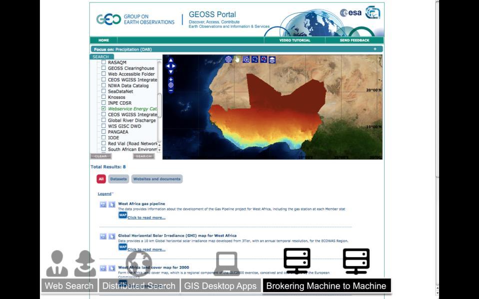
3 Purpose of the Catalog Describes energy resources into an unified, open, standard and interoperable format: ISO 19115/19139 METADATA Access to resources through standard protocol: OGC CSW (Catalog Service for the Web) What for? Enable Search & Discovery Leverage Dissemination & Knowledge How to? Manual editing Machine to machine scheduled harvest Accessible in the Global Atlas! Renewable Energy Resources 3


4 Catalog: The Cornerstone of the data infrastructure Energy Resources from Global Atlas Data Providers


5 BEST PRACTICES SYNERGIES 5
6 HelioClim1 Web Processing Service The HelioClim-1 database of MINES ParisTech offers daily values of Surface Solar Irradiation (SSI) for the period based on images of the Meteosat First Generation. WPS allows to compare up to five locations at a time and get summary time series of irradiations in Wh/m2, W/m2, MJ/m2 as well as Clear sky conditions and at the Top of Atmosphere on a daily, monthly or yearly basis HelioClim-1 Facts and Constrains: 20 years of data (One image per day) Stored into a proprietary format (Around 8 Go of disk space) Servers are inside private network, no direct access to Internet Solution: Creation of an interface component as Web Processing Service (WPS) OGC Standard 6
7 HelioClim1 Web Processing Service Private Servers Public Server Internet HTTP protocol Applications WPS Web Apps Desktop Apps Mobile Apps Legacy Application/Data WPS Platform Interface Apps invokes Web Processing Service Simplified Sequence Diagram 7

8

9

10
11 HelioClim1 Web Processing Service Benefits Convenient mean to share legacy data over the Web Write once invoke through multiple devices Synchronous and Asynchronous processing Mature and robust Open Standard (OGC/WPS V 2.0) Community driven (vs vendor driven) Open Source WPS solution platforms Commonly used in Geospatial Industry 11
12 In-situ Mea surement Sensor Observa tion Service Rationales Keys information in daily activities of many actors in the renewable energy domain. In solar domain: Surface Solar Irradiance (SSI) Associated measurements Temperature, relative humidity, atmospheric pressure,. Enable policy-makers to set up energy policies from local to national levels: The long-term solar resource assessment for a specific site Technical sizing and yield report simulations. The solar resource prospective with solar maps integrated in GIS. The monitoring of existing solar power plant for operation and maintenance. The multi-horizon forecast for energy storage, planning or participation to electricity spot market. 12
13 In-situ Mea surement Sensor Observa tion Service Users: In-situ measurements should be: easy to find, easy to search, easy to access and consequently easy to use Providers: In-situ measurements should be: easy to register, easy to qualify, easy to process. Approach: Deploy an infrastructure in order to: collect, store check and qualify in-situ measurements, provide a mean to access them using international standard such as the OGC (Open Geospatial Consortium) SWE (Sensor Web Enablement) standard framework. 13


14 WebGIS Client Global Atlas Access to In situ Measurements Webservice-Energy Catalog <Metadata ISO 19139> GEOSS Portal <Harvest> <Invoke SOS> <Harvest SOS> SOS Infrastructure SOS Infrastructure SOS Infrastructure Internal Processes Data Quality Checked OGC Sensor Observation Service In situ measurements database Data Gap Filed RAW Data Verified Global Atlas In-situ Measurement integration into a Sensor Web Interoperable Infrastructure
15 Thanks for your Attention! Lionel Menard: 15
GEO VENER: GEO Vision for ENERgy
 GEO VENER: GEO Vision for ENERgy Thierry Ranchin Lionel Ménard Centre Observation, Impacts, Energy MINES ParisTech GEO and GEOSS GEO VENER: GEO Vision for Energy GEO Initiative supporting the Energy and
From Academic to Industry for Solar Resources. MINES ParisTech Lionel Menard
 From Academic to Industry for Solar Resources MINES ParisTech Lionel Menard Solar Resource Assessment with the Global Atlas for Renewable Energy ISES Webinar 16/06/2016 1 MINES ParisTech MINES ParisTech
GEOSPATIAL SDI PRODUCT BROCHURE
 GEOSPATIAL SDI PRODUCT BROCHURE 2 Geospatial SDI GEOSPATIAL SDI Geospatial SDI is an interoperable and scalable component of spatial data infrastructure for cataloging and delivering enterprise geospatial
POWER PORTFOLIO PRODUCT BROCHURE
 POWER PORTFOLIO PRODUCT BROCHURE 2 Power Portfolio Change is constant and its impacts can affect you personally. Whether man-made or naturally occurring, our changing landscape influences your plans and
PRODUCT BROCHURE POWER PORTFOLIO
 PRODUCT BROCHURE POWER PORTFOLIO 2 Power Portfolio Change is constant and its impacts can affect you personally. Whether man-made or naturally occurring, our changing landscape influences your plans and
12th UNGIWG Plenary Meeting ArcGIS for UNGIWG and UNSDI
 12th UNGIWG Plenary Meeting ArcGIS for UNGIWG and UNSDI ssawaya@esri.com / @salim_sawaya Many people want your authoritative knowledge Co-workers Executives & decision makers Customers Citizens Co-workers
Response to Call for Participation (CFP) OGC - GEOSS Pilot Southeastern Universities Research Association (SURA)
 OGC - GEOSS Pilot Southeastern Universities Research Association (SURA)") Response to Call for Participation (CFP) OGC - GEOSS Pilot 2008 Southeastern Universities Research Association (SURA) National Incident Management Systems and Advanced Technologies (NIMSAT) Gulf of Maine
Response to Call for Participation (CFP) OGC - GEOSS Pilot 2008 Southeastern Universities Research Association (SURA) National Incident Management Systems and Advanced Technologies (NIMSAT) Gulf of Maine
Deploying Info Clouds to Rapidly Deliver Actionable Information to Stakeholders. Brad Schmidt Business Development, Intergraph Canada
 Deploying Info Clouds to Rapidly Deliver Actionable Information to Stakeholders Brad Schmidt Business Development, Intergraph Canada Agenda Why do we need Info Clouds What is an Information Cloud What
Environmental impact for offshore wind farms: Geolocalized Life Cycle Assessment (LCA) approach
 approach") Environmental impact for offshore wind farms: Geolocalized Life Cycle Assessment (LCA) approach Catherine Guermont, Lionel Menard, Benoît Gschwind, Isabelle Blanc, Thierry Ranchin To cite this version:
Environmental impact for offshore wind farms: Geolocalized Life Cycle Assessment (LCA) approach Catherine Guermont, Lionel Menard, Benoît Gschwind, Isabelle Blanc, Thierry Ranchin To cite this version:
CIM Forum Charter Dated
 CIM Forum Charter Dated 2018-12-18 The information provided below is subject to change and reflects the current state of the CIM Forum charter within the DMTF. Management Problem(s) and Environment The
Declan Dunne University College Cork
 Declan Dunne University College Cork COMMON SENSE Web Platform COMMON SENSE FINAL EVENT Barcelona, Spain, 27 January 2017 Background Adding value to Environmental Science using ICT and Geomatics COMMON
WP-9 The GMOS Interoperable System
 WP-9 The GMOS Interoperable System Sergio Cinnirella CNR-IIA Outline The state of the art Goals of WP 9 The road to implement the system Who will do what A very brief presentation of EGIDA (S. Nativi)
Bridging the Gap Between Research and IT. 22 June 2010 Conrad Agramont Product Management Andrew Leuthe Product Marketing
 Bridging the Gap Between Research and IT 22 June 2010 Conrad Agramont Product Management Andrew Leuthe Product Marketing Productivity Continuum Self Service Captured Knowledge Reusability Collaboration
OGC Open Geospatial Consortium
 OGC Open Geospatial Consortium Technology Office 4899 North Old State Road 37 Bloomington, IN 47408 Telephone: +1-812-334-0601 Facsimile: +1-812-961-2053 Request for Quotation (RFQ) And Call for Participation
ArcGIS for Water Utilities
 ArcGIS for Water Utilities Mark Robbins Joe Morocco Agenda Introductions ArcGIS for Water Utilities Overview Demonstrations Getting Started with ArcGIS for Water Utilities Common Deployment Scenarios Discussion
Farm-Oriented Open Data in Europe
 Farm-Oriented Open Data in Europe GEOSS Architecture Implementation Pilot 8 Agriculture and Water Pollution Monitoring Tomáš ŘEZNÍK (Masaryk University/WIRELESSINFO) w w w. f o o d ie- p r o j e c t. eu
IT for space Systems. A project oriented view of IT in space projects
 IT for space Systems A project oriented view of IT in space projects Andrea Bennetti Client Relationship Manager Tel +31629350733 andrea.bennetti@sapienzaconsulting.com April 28 th 2010 Content Who is
I. Interoperable Data Discovery, Access, and Archive
 Data Management and Communications Plan for Research and Operational Integrated Ocean Observing Systems I. Interoperable Data Discovery, Access, and Archive Executive Summary May 10, 2004 1 2 Executive
Symphony IoT. Solar Farm Manager. Product Brief
 Symphony IoT Solar Farm Manager Product Brief Satellite technology for reliable, 24X7 monitoring of PV systems, anywhere in the world. By their very nature, photovoltaic installations tend to be in hard-to-reach
Implementing ArcGIS Solutions. Michael Beavers
 Implementing ArcGIS Solutions Michael Beavers mbeavers@esri.com ArcGIS as a Platform Simple, Open, and Configurable Knowledge Workers Executive Access Public Engagement Work Anywhere Enterprise Integration
Implementing Microsoft Azure Infrastructure Solutions
 Course 20533C: Implementing Microsoft Azure Infrastructure Solutions Course Outline Module 1: Introduction to Azure This module introduces cloud solutions in general and then focuses on the services that
This module introduces students to cloud services and the various Azure services. It describes how to
 Course Outline Module 1: Getting Started with Microsoft Azure This module introduces students to cloud services and the various Azure services. It describes how to use the Azure portal to access and manage
GEO-CRADLE project in context of regional needs
 GEO-CRADLE project in context of regional needs Funded under H2020 - Climate action, environment, resource efficiency and raw materials ACTIVITY: Developing Comprehensive and Sustained Global Environmental
Energistics Standards v2.0. Jay Hollingsworth CTO
 Energistics Standards v2.0 Jay Hollingsworth CTO Agenda» Energistics» Transfer standards 2.0» Energistics MLs 2015 Energistics 2 Energistics Energistics is a global, nonprofit, membership consortium that
Enabling GIS in Distribution Utility for Energy Audit and Load flow analysis
 Enabling GIS in Distribution Utility for Energy Audit and Load flow analysis Jayant Sinha Associate Vice President (Power/ IT) Spanco Ltd. Abstract: About the Author: In the nationwide implementation of
GNU FDL Lizenz
 Introduction to Geoportal Management using Mapbender Orchestrating the Geospatial Concert a FOSS and OGC compliant Geoportal Software FOSS4G Workshop Arnulf Christl arnulf@osgeo.org http://www.wheregroup.com
Open Geospatial Consortium
 Open Geospatial Consortium Technology Office 4899 North Old State Road 37 Bloomington, IN 47408 Telephone: +1-812-334-0601 Facsimile: +1-812-961-2053 Request For Quotation And Call For Participation In
can boost global IoT success
 How OpenLabs can boost global IoT success With 22 OpenLabs around the globe, including 8 jointly developed with telcos, Huawei is committed to open partnerships and success for all in the IoT domain. So,
Course 20533C Implementing Microsoft Azure Infrastructure Solutions
 Course Outline Module 1: Introduction to Azure This module introduces cloud solutions in general and then focuses on the services that Azure offers. The module goes on to describe the portals that you
CHAPTER 3 ENTERPRISE SYSTEMS ARCHITECTURE
 CHAPTER 3 ENTERPRISE SYSTEMS ARCHITECTURE 1 Learning Objectives Examine in detail the enterprise systems modules and architecture. Understand the effects of a well-designed architecture on ERP implementation.
GIS as a Foundation for Command & Control. Tom Smedley Milquiades Walther-Rodriguez
 GIS as a Foundation for Command & Control Tom Smedley Milquiades Walther-Rodriguez Agenda Trends in Command and Control & GIS What is Web GIS Use Cases GIS Platform Approach to Command and Control Trends
Government Collaboration and Public Distribution with Spatial Data Infrastructure
 Government Collaboration and Public Distribution with Spatial Infrastructure FIG Working Week 2009 workshop Eilat, Israel, 3-8 May 2009 Stanislav Šumbera, Technical Architect, Intergraph Gideon Altman,
Geo-standarder för system idag och i framtiden
 Geo-standarder för system idag och i framtiden 2009-11-19 Lars Schylberg Saab Agenda Introduction OGC Architecture OGC What is next (OWS-experiments) GIS up until today or yesterday Desktop Applications
GIS as an Integral Part of the BML Concept
 GIS as an Integral Part of the BML Concept ESRI BML conference at GMU Oct 16-17 17 16 Oct 2007 1 Overview Large Trends in Geospatial Community Collaboration SOA Vision and Implementation Reference Implementation
Implementing Microsoft Azure Infrastructure Solutions
 Implementing Microsoft Azure Infrastructure Solutions Duration: 5 Days Course Code: 20533C About this Course: This course is intended for IT professionals who are familiar with managing on-premises IT
Enterprise GIS Projects: Challenges and Solutions
 Enterprise GIS Projects: Challenges and Solutions Anil K. Jayavarapu ABSTRACT. Enterprise GIS projects are complex. These projects involve coordination and communications between multiple parties. These
GeoPlatform Today December 7, 2016
 GeoPlatform Today December 7, 2016 GeoPlatform Today: Topics 1-8 Patrick Neal / Image Matters LLC Topic 1: Marketplace Topic 2: Dataset Search Topic 3: Map Viewer Topic 4: Map Manager Jeff Harrison / Carbon
Implementing ArcGIS Solutions NIKKI GOLDING SCOTT OPPMANN
 Implementing ArcGIS Solutions NIKKI GOLDING SCOTT OPPMANN Agenda (Update) Introduction Implementation Patterns Opioid Epidemic Solution Configuration Approaches Your Feedback ArcGIS as a Platform Simple,
DRAFT ENTERPRISE TECHNICAL REFERENCE FRAMEWORK ETRF WHITE PAPER
 DRAFT ENTERPRISE TECHNICAL REFERENCE FRAMEWORK ETRF WHITE PAPER CONTENTS CONTENTS... 0 INTRODUCTION... 1 VISION AND OBJECTIVES... 1 ARCHITECTURE GUIDING PRINCIPLES... 1 ENTERPRISE TECHNICAL REFERENCE FRAMEWORK
BACSOFT IOT PLATFORM: A COMPLETE SOLUTION FOR ADVANCED IOT AND M2M APPLICATIONS
 BACSOFT IOT PLATFORM: A COMPLETE SOLUTION FOR ADVANCED IOT AND M2M APPLICATIONS What Do You Need to Ensure a Successful Transition to IoT? As the business climate grows ever more competitive, industrial
What Do You Need to Ensure a Successful Transition to IoT?
 What Do You Need to Ensure a Successful Transition to IoT? As the business climate grows ever more competitive, industrial companies are looking to the Internet of Things (IoT) to provide the business
Yphise portfolio of valuable projects
 Yphise portfolio of valuable projects Independent investment recommandations since 1985 Software Project EXECUTIVE WHITE PAPER SUCCEEDING WITH PROACTIVE IT With ASG s metacmdb BSC Business Strategy and
Tascent Enterprise Suite Multimodal Biometric Identity Platform
 TM Tascent Enterprise Suite Multimodal Biometric Identity Platform tascent.com Multimodal Biometric Identity System Secure, scalable, and easy-to-use, the Tascent Enterprise Suite represents a thoroughly
ONVIF Corporate Presentation. October 2018
 ONVIF Corporate Presentation October 2018 Table of Contents About ONVIF About ONVIF, Mission & Vision Evolution of ONVIF, Major Milestones Committee Structure, Members The Profile Concept The Profile Concept
Data Collection for GIS. April 9, 2015 Frontier Precision User Group
 Data Collection for GIS April 9, 2015 Frontier Precision User Group Goal Overview of the InSphere Platform and our goals to make better data management tools for you Deep dive on a couple of software products
Geothermal Prospector: Supporting Geothermal Analysis Through Spatial Data Visualization and Querying Tools
 GRC Transactions, Vol. 39, 2015 Geothermal Prospector: Supporting Geothermal Analysis Through Spatial Data Visualization and Querying Tools Daniel Getman 1, Arlene Anderson 2, and Chad Augustine 1 1 National
Open Standards in Practice: An OGC China Forum Initiative
 IOP Conference Series: Earth and Environmental Science PAPER OPEN ACCESS Open Standards in Practice: An OGC China Forum Initiative To cite this article: Peng Yue et al 2016 IOP Conf. Ser.: Earth Environ.
Government Collaboration and Public Distribution with Spatial Data Infrastructures
 Government Collaboration and Public Distribution with Spatial Data Infrastructures Gideon ALTMAN and Stanislav ŠUMBERA, Israel Key word: e-governance, Geoinformation/GI, GSDI, geoportal, Intergraph SUMMARY
Worldwide Exchange of Water Data
 Worldwide Exchange of Water Data Fernando R. Salas and David R. Maidment Center for Research in Water Resources University of Texas at Austin 2014 AWRA Spring Specialty Conference: GIS and Water Resources
Towards Inter-jurisdictional Interoperability for a Sustainable Management of the St. Lawrence Ecosystem
 Towards Inter-jurisdictional Interoperability for a Sustainable Management of the St. Lawrence Ecosystem Joanne Hamel Scientific Coordinator, St. Lawrence Observatory, DFO St. Lawrence Global Observatory
2017 Exchange Network National Meeting Innovation and Partnership. May 16-18, 2017 Sheraton Philadelphia Society Hill Hotel Philadelphia, Pennsylvania
 INTEROPERABLE WATERSHEDS NETWORK (Continuous Monitoring Pilot) Dwane Young, U.S. EPA Office of Water Mike Kusmiesz, NJ Department of Environmental Protection 2017 Exchange Network National Meeting Innovation
Implementing Microsoft Azure Infrastructure Solutions EXAM
 Implementing Microsoft Azure Infrastructure Solutions EXAM 70-533 Contents Module 1: Introduction to Azure This module introduces cloud solutions in general and then focuses on the services that Azure
A technical discussion of performance and availability December IBM Tivoli Monitoring solutions for performance and availability
 December 2002 IBM Tivoli Monitoring solutions for performance and availability 2 Contents 2 Performance and availability monitoring 3 Tivoli Monitoring software 4 Resource models 6 Built-in intelligence
CODATA Data Archiving Activities
 CODATA Data Archiving Activities Bill Anderson Co-chair CODATA Data Preservation Task Group ERPANET/CODATA International Workshop on the Selection, Appraisal, and Retention of Scientific Data 15-17 December
Water Resources Observation Network
 Water Resources Observation Network Ross Ackland WRON Theme Leader, CSIRO SEEGrid-III December 1 st 2006 Enabling a national perspective on Australia s water resources... 1 Murray Darling system is running
Vision for an Upstream Reference Architecture
 Vision for an Upstream Reference Architecture Business factors in the upstream oil and gas industry are driving the need for an information technology (IT) architecture that provides a common reliable
INTEGRATING PING IDENTITY SOLUTIONS WITH GOOGLE IDENTITY SERVICES
 INTEGRATING PING IDENTITY SOLUTIONS WITH GOOGLE IDENTITY SERVICES How two technologies work together to add more value to your enterprise TABLE OF CONTENTS 03 04 05 06 07 08 08 08 EXECUTIVE SUMMARY INTEGRATION
Developing Standards that enable Interoperable IT Management
 Developing Standards that enable Interoperable IT Management The Growing Importance of Management Standards for IT With the ever-increasing need for flexibility, availability and performance in today s
The Provision Of Data From The COSMOS-UK Soil Moisture Monitoring Network
 City University of New York (CUNY) CUNY Academic Works International Conference on Hydroinformatics 8-1-2014 The Provision Of Data From The COSMOS-UK Soil Moisture Monitoring Network Matthew J. Fry Jonathan
A couple of M2M Research Activities in Telenor - A distributed M2M Service Platform. Stein Svaet, June 4, 2008
 A couple of M2M Research Activities in Telenor - A distributed M2M Service Platform Stein Svaet, June 4, 2008 (stein-wegard.svaet@telenor.com) Outline What are we doing? Reference Architecture CO Top-Level
SOA Research Agenda. Grace A. Lewis
 Workshop SOA Research Agenda Grace A. Lewis Workshop Approach Broadened the scope of the research agenda to show that we are interested in more than just SOA as an architectural style Performed an extensive
Edison SmartConnect. The Role of IT in. John Bubb Southern California Edison Edison SmartConnect TM May 20, 2008
 Edison SmartConnect The Role of IT in Smart Grid Infrastructure John Bubb Southern California Edison Edison SmartConnect TM May 20, 2008 PG&E LADWP SCE SDG&E SCE Overview Serving over 13 million people
Nicx Limited Cloud Computing
 Cloud Computing With the acquisition of SuccessFactors (SDN) it's time to have a look at some of the basic 'Cloud' theory and terminology. System Landscape of the Cloud Cloud computing is the delivery
GEOMEDIA SMART CLIENT DYNAMICALLY JUMPSTART YOUR GIS PRODUCT BROCHURE
 GEOMEDIA SMART CLIENT DYNAMICALLY JUMPSTART YOUR GIS PRODUCT BROCHURE 2 GeoMedia Smart Client Dynamically Jumpstart Your GIS IS YOUR GEOGRAPHIC INFORMATION SYSTEM (GIS) GRIDLOCKED IN A DEPARTMENT? LIMITED
The Power of Spatially Enabling Your Real-time Facilities Data. Copyright 2015 OSIsoft, LLC
 The Power of Spatially Enabling Your Real-time Facilities Data Presented by James Sullivan Recommended Flow of Topics in Agenda Business Challenge About GIS ArcGIS Platform and the PI System Create and
MapInfo Professional. Comprehensive Insight for Location-powered Decision-making and Data Analysis
 MapInfo Professional Comprehensive Insight for Location-powered Decision-making and Data Analysis With MapInfo Professional, you can visualize the relationships between data and geography. So business
The Strategy of LGGI and future directions towards Enterprise Products and
 The Strategy of LGGI and future directions towards Enterprise Products and Overview and Update Solution Geosystems Poland User Group Meeting June 15, 2007 Dr. Thomas Bayer, Director Sales Europe & CIS
April Oracle Spatial User Conference
 Oracle Spatial User Conference Ron Little Oshawa PUCN Geoff Cameron - AGSI An Innovative and Open Approach to Utilities Network Management at Oshawa PUC Agenda OPUCN Geospatial History Approach Process
Guide to Modernize Your Enterprise Data Warehouse How to Migrate to a Hadoop-based Big Data Lake
 White Paper Guide to Modernize Your Enterprise Data Warehouse How to Migrate to a Hadoop-based Big Data Lake Motivation for Modernization It is now a well-documented realization among Fortune 500 companies
cxl ontology system, Cyscom Biznet Services work flow and business applications Get to know the power of cxl
 cxl ontology system, Cyscom Biznet Services work flow and business applications Get to know the power of cxl cxl structures, enriches and semantically maps product data into a repository for work flow
GIS vs CAD. Why GIS is better suited to handle field mapping than CAD
 GIS vs CAD Why GIS is better suited to handle field mapping than CAD 1 Within the O&G industry GIS is used at several stages of the Oil and Gas process. Here is a brief list of applications within the
Evolving your Integration Infrastructure using webmethods Mediator
 Evolving your Integration Infrastructure using webmethods Mediator Subhash Ramachandran, VP Product Management Sachin Gadre, Manager, Product Management Tuesday, June 29, 2010 Agenda Solving the Integration
EUDAT How manage Data into the Collaborative Data Infrastructure: a general overview of EUDAT services
 EUDAT How manage Data into the Collaborative Data Infrastructure: a general overview of EUDAT services Giovanni Morelli www.eudat.eu EUDAT receives funding from the European Union's Horizon 2020 programme
EPA's Interoperable Watersheds Network - A New Approach for Publishing Continuous Monitoring Data. Dwane Young, U.S. EPA Office of Water
 EPA's Interoperable Watersheds Network - A New Approach for Publishing Continuous Monitoring Data Dwane Young, U.S. EPA Office of Water Outline An Introduction to Standards : The World is Built on Standards!
SAS Decision Manager
 SAS Decision Manager A Technical Supplement James Taylor CEO SAS Decision Manager combines business rules management with predictive analytic models and analytic model management. These capabilities are
A Fresh Look at the Mainframe
 A Fresh Look at the Mainframe Unlock the Value of Your Mainframe Assets Using SOA On Demand Insurance Business Problems 1. We want to increase revenues by selling insurance polices through external Brokers
Network Performance and Operational Analytics 24/7
 Network Performance and Operational Analytics 24/7 View The IoT Platform for Water Systems with Built-In Analytics Designed by Water professionals for Utility Engineers Integrated Data Management and Network
Service Virtualization
 Service Virtualization A faster, more efficient and less costly way to develop and test enterprise-class applications As cloud and mobile computing gain rapid acceptance, IT departments are expected to
Smart Factory Web: Goals. Smart Factory Web: a testbed for IIC and Industrie 4.0 8/22/2018
 Smart Factory Web: a testbed for IIC and Industrie 4.0 Presenter: Dr Kym Watson, Fraunhofer IOSB Team: KETI: Byunghun Song, Seungwook Nam Fraunhofer IOSB: Thomas Usländer, Jürgen Jasperneite, Ljiljana
Security & Defense Solutions
 intelligent convergence TM Security & Defense Solutions Intelligent Convergence with Augusta Systems EdgeFrontier White Paper The Need for Intelligent Convergence The distributed and evolving nature of
Sensors, Standards, and Situational Awareness - Advancing GeoInt Capabilities in Asia-Pacific
 Sensors, Standards, and Situational Awareness - Advancing GeoInt Capabilities in Asia-Pacific Trevor Taylor ttaylor@opengeospatial.org Director, Services for Asia and the Americas Why? The place for ad-hoc
GEOSTORM ON EO IPT POLAND: A PRIVATE INITIATIVE TO PROVIDE EO ADDING VALUE DATA IN A GEOSPATIAL PLATFORM
 GEOSTORM ON EO IPT POLAND: A PRIVATE INITIATIVE TO PROVIDE EO ADDING VALUE DATA IN A GEOSPATIAL PLATFORM Mickaël SAVINAUD, mickael.savinaud@c-s.fr 13/06/2018 CONCEPTEUR, OPÉRATEUR & INTÉGRATEUR DE SYSTÈMES
Fostering Business Consumption With Automation & Orchestration Of IT Services. Antoine Acklin Head of Consulting, Australia & New Zealand
 Fostering Business Consumption With Automation & Orchestration Of IT Services Antoine Acklin Head of Consulting, Australia & New Zealand 1 IT AS A SERVICE 62% 70% BUSINESS LEADERS IT LEADERS Business leaders
Harmful Algal Bloom Use Case. Leveraging the ACT Architecture For Coastal Zone Management
 Applied Coherent Technology, Corp. Harmful Algal Bloom Use Case Leveraging the ACT Architecture For Coastal Zone Management (ACT-REACT TM Workstation and WIPE TM Server) www.actgate.com Table of Contents
ArcGIS for Water Utilities: An Introduction
 Esri International User Conference San Diego, California Technical Workshops July 26, 2012 ArcGIS for Water Utilities: An Introduction Howard Crothers Mike Miller Agenda Introduction ArcGIS for Water Utilities
GENeric European Sustainable Information Space for Environment.
 GENeric European Sustainable Information Space for Environment http://www.genesis-fp7.eu/ Outline of the presentation 2 Introduction INSPIRE as a driver GENESIS Project Key use cases from INSPIRE Annex
A spatial data infrastructure for. Portuguese National Health Plan GEOSAÚDE. Eduardo Coelho
 A spatial data infrastructure for Portuguese National Health Plan GEOSAÚDE Eduardo Coelho eduardo.coelho@novageo.pt Introduction to the Project Methodology Hardware & Software Architecture Project Results
SunGard: Cloud Provider Capabilities
 SunGard: Cloud Provider Capabilities Production and Recovery Solutions for Mid-Sized Enterprises www.sungardas.com Agenda Our Mission Use Cases Cloud Strategy Why SunGard 2 Our Mission Enable mid-sized
Enterprise IT Architectures SOA Part 3
 Enterprise IT Architectures SOA Part 3 Hans-Peter Hoidn hans-peter.hoidn@ch.ibm.com November 26, 2007 SOA Because Innovation Requires Change and SOA Makes Change Easier a service? A repeatable business
Process and Workflow Management
 Software IBM Software Group Process and Workflow Management ing Integration e efficient and flexible combination of resource to optimize operations across and beyond the enterprise + + People Processes
Product Model Technology and Solution Requirements from the Finnish Viewpoint. Use of Building Product Models
 Product Technology and Solution Requirements from the Finnish Viewpoint Dr. Arto Kiviniemi, Chief Research Scientist Use of Building Product s Confederation of Finnish Construction Industries RT The Finnish
OpenText RightFax. OpenText RightFax OnDemand. Product Brochure. Benefits
 OpenText RightFax OnDemand Benefits Reduced IT Load Managed by fax experts Disaster recovery service Redundancy options Complete Control Centralized fax management You own your data Bring and keep your
VDI. Citrix Cloud Services Adrian Fish
 VDI Citrix Cloud Services 1 Citrix Cloud Services & How this changes how you deliver IT 2 About Citrix Cloud Citrix Cloud is a delivery and management platform that enables faster set up and time-to-value
THE INTERNET OF THINGS
 THE INTERNET OF THINGS Maker Board Designs To Industrial Grade Systems Building The Real Internet of Things Matt Newton Director of Technical Marketing Opto 22 Overview A Bigger Opportunity Industrial
Analytics in Action transforming the way we use and consume information
 Analytics in Action transforming the way we use and consume information Big Data Ecosystem The Data Traditional Data BIG DATA Repositories MPP Appliances Internet Hadoop Data Streaming Big Data Ecosystem
Configuring the ArcGIS for Local Government Solution CHRIS FOX SCOTT OPPMANN
 Configuring the ArcGIS for Local Government Solution CHRIS FOX SCOTT OPPMANN Agenda Introduction Implementation Patterns Configuration Approaches Your Feedback ArcGIS as a Platform Simple, Open, and Configurable
COURSE OUTLINE: Course 20533C- Implementing Microsoft Azure Infrastructure Solutions
 Course Name Course Duration Course Structure Course Overview 20533C-Implementing Microsoft Azure Infrastructure Solutions 5 Days Instructor-Led This course is intended for IT professionals who are familiar
IT Governance Overview
 IT Governance Overview Contents Executive Summary... 3 What is IT Governance?... 4 Strategic Vision and IT Guiding Principles... 4 Campus-Wide IT Strategic Vision... 4 IT Guiding Principles... 4 The Scope
Copyright 2015 Infor. All rights reserved. This presentation is provided for informational purposes only and does not constitute a commitment in any
 1 Achieve Fast and Easy Upgrades for CloudSuite Industrial (SyteLine) SYTL-1001 Alan Hays Infor Consulting Services 2 Full disclaimer This presentation reflects the direction Infor may take with regard
THE FUTURE INTERNET ENABLEMENT OF THE ENVIRONMENT INFORMATION SPACE
 THE FUTURE INTERNET ENABLEMENT OF THE ENVIRONMENT INFORMATION SPACE ISESS 2013 Neusiedl, 10/10/2013 Thomas Usländer, Fraunhofer IOSB Three phases of the Future Internet Programme (FI-PPP) Phase 2: Apr