Request Modification of Conditions (Modification of conditions of existing Conditional Use Permit approved on March 22, 2011 to expand a borrow pit)
|
|
|
- Norman Mathews
- 6 years ago
- Views:
Transcription


1 Applicant/Property Owner Public Hearing March 9, 2016 City Council Election District Beach Agenda Item 4 Request Modification of Conditions (Modification of conditions of existing Conditional Use Permit approved on March 22, 2011 to expand a borrow pit) Staff Planner Carolyn A.K. Smith Location 2297 Harpers Road GPIN Election District Beach Site Size acres AICUZ Greater than 75 db DNL Existing Land Use Borrow pit, woods Surrounding Land Uses and Zoning Districts North Harpers Road Oceana Naval Air Station Single-family dwellings, VBCPS school bus depot, cultivated fields / B-2 Community Business, I-2 Heavy Industrial, AG-1 Agricultural South Dam Neck Road Cultivated fields, undeveloped property / AG-1 Agricultural East Undeveloped property / AG-1 Agricultural West Harpers Road Oceana Naval Air Station Undeveloped property / AG-1 Agricultural Page 1

2 Background and Summary of Proposal The property was granted a Conditional Use Permit by the Virginia Beach City Council on March 22, 2011 to allow development of the site for a 25-acre borrow pit. The applicant is seeking a Modification to the Conditional Use Permit in order to expand the pond by 40 acres and excavate the remaining sand on the 328-acre property. The 40-acre expansion will connect to the existing 25-acre borrow pit, portions of which are currently being filled. It is anticipated that approximately 1,613,000 cubic yards of material will ultimately be excavated from the expansion area. The excavation of the material is estimated to take eight years; however, the ultimate time frame will depend on the demand. The 2011 request indicated that excavation of the borrow pit would be completed by The operator has mined much quicker than anticipated. The site borders both Harpers and Dam Neck Roads and is zoned agricultural. A Navy Restrictive Easement covers the northern portion of the property. The property is surrounded predominately by cultivated fields and forested land; however, there are several single-family dwellings on property to the north. The edge of the area to be excavated is depicted on the submitted concept plan as 150 feet from the nearest property line, exceeding the minimum standard of 100 feet as required by the Zoning Ordinance. The heavily wooded, 150-foot wide buffer between the pit and these properties will remain. The right-in/right-out ingress/egress point along Dam Neck Road will continue to be used and access to the expansion will be via an extension of the existing private driveway. The existing landscape berm will remain and an overburden storage area is planned to the south east of the proposed borrow pit. 1 Zoning History # Request 1 CUP (Borrow Pit) Approved 03/22/11 CUP Conditional Use Permit REZ Rezoning CRZ Conditional Rezoning Application Types MOD Modification of Conditions or Proffers NON Nonconforming Use STC Street Closure FVR Floodplain Variance ALT Alternative Compliance SVR Subdivision Variance Page 2
3 Comprehensive Plan Recommendations The Comprehensive Plan designates the subject property as being within the Suburban Area Special Economic Growth Area 3 (SEGA 3) South Oceana. South Oceana is a large hourglass shaped tract of land encompassing properties on both sides of Dam Neck Road between Holland Road and Corporate Landing Business Park. The Plan recommends that all land uses in this area align with the City s AICUZ provisions and the Oceana Land Use Conformity program. (p. 3-32) Natural and Cultural Resources Impacts This property is within the Southern Rivers watershed. The large, 328-acre parcel contains cultivated fields, wooded areas as well as a 25-acre borrow pit near the end of its life cycle. The proposed borrow pit expansion will require the removal of much of the woods. A buffer of trees along Dam Neck Road will remain. It does not appear that any cultural resources are present on the site. Traffic Impacts Street Name Present Volume Present Capacity Generated Traffic Dam Neck Road 20,103 ADT 1 32,500 ADT 1 (LOS 4 C ) 37,100 ADT^1 (LOS E ) Existing Land Use ADT Harpers Road 7,917 ADT 1 6,200 ADT 1 (LOS 4 C ) Proposed Land Use ADT 11,100 ADT 1 (LOS 4 E ) 1 Average Daily Trips 2 as defined by 238 acres zoned AG-2 3 as defined by 150 trucks daily plus 3 employees on site (assumed) during operating hours 4 LOS = Level of Service Master Transportation Plan (MTP) and Capital Improvement Program (CIP) The site borders both Harpers Road and Dam Neck Road. The existing access off of Dam Neck Road will continue to be used. Dam Neck Road is a four-lane, divided, major suburban arterial, limited-access roadway with a 165-foot right-ofway width with both a sidewalk and a bike path. The City s MTP depicts Dam Neck Road to ultimately be a six-lane divided parkway in this area, but there are currently no CIP projects scheduled for this segment of the roadway. Harpers Road is a two-lane collector with a 25-foot right-of-way width (and approximately 18 to 25 feet of pavement). Harpers Road is shown on the MTP as an undivided, four-lane, major collector with a 100-foot right-of-way width. There are no current roadway CIP projects scheduled for this segment of Harpers Road. Public Utility /Ground Water Impacts Information on the dewatering operation such as location, volume to be discharged, and the rate of discharge will be required during the site plan review process. As with any dewatering operation, there is always a small potential for surrounding, shallow wells to be impacted; however, it does not appear that there are any shallow withdrawal wells within a 1,000 foot radius of the proposed excavation areas. According to the Health Department, the residential properties adjacent to this site do not have permitted wells; however, it does not appear that these homes are connected to City water service either. The applicant s engineer indicated that should any unpermitted wells exist or new shallow wells be installed along Harpers Road, the relatively shallow depth of dewatering (approximately 20 feet) is not deep enough for the effect to propagate offsite to a level that could impact well yield or water quality. In addition, the applicant s engineer stated that there are no significant groundwater withdrawal activities located within a 5,000- foot radius of the proposed excavation area, so it is likely that no other activities can be adversely impacted. A thorough review of the location of all wells in the vicinity will be performed prior to the issuance of any permits related to the Page 3
4 borrow pit expansion. The City Public Schools facility located at 1677 Harpers Road has a permit for a geothermal well(s). These closed-loop systems are not impacted by changes in the water table. Evaluation and Recommendation The Modification of Conditions request for a borrow pit expansion of 40 +/- acres of sand excavation is generally consistent with the Comprehensive Plan s land use policies for SEGA 3 - South Oceana, particularly with regard to adhering to reinforcing industrial and commercial uses that are compatible with the surrounding area. However, it should be noted that the SEGA 3 is viewed as a special area with significant economic value and growth potential. The property has significant development potential based on its size and location along the four-lane Dam Neck Road. The size and location of the excavation significantly diminishes the future development potential for the parcel. While Staff is aware that the location of a sand mining operation is dependent upon the location of sand below grade, in a perfect world, a coordinated future development plan of the property would depict the reclaimed borrow pit strategically located to serve as a future stormwater management facility, if and when the property is fully developed. As a result of Staff s request for a conceptual master plan of the property, the applicant s representative provided the following: the future use of the property will be within the constraints of the Navy purchased easements and the City of Virginia Beach zoning ordinance. The initial borrow pit will be backfilled with inert soils to the extent shown on the new application. The new borrow pit will ultimately be partially backfilled with inert soils and part may remain a lake to be used in a future unidentified development. A Navy Restrictive Easement was acquired on a portion of the property in The majority of the proposed 40-acre expansion is within this easement area. Navy Staff indicated that the proposed expansion, as well as the current borrow pit, increases the risk associated with aircraft bird strikes. Recommendations to reduce this risk of conflicts between aircraft and birds is reflected in the recommended condition 4 below. Correspondence from the Virginia Department of Mines, Minerals and Energy (DMME) revealed no violations or issues with the operation of the existing 25-acre borrow pit. The applicant has routinely submitted the required information in conformance with the State of Virginia DMME and VPDES permits. These permits, which will be amended to reflect the expansion, remain in effect for the life of the borrow pit. There was significant discussion with the Traffic Engineering Staff in 2011 regarding traffic safety concerns on Dam Neck Road. Specifically, there was fear that slow moving dump trucks entering Dam Neck Road would not be able to accelerate as quickly as passenger vehicles, resulting in either travel delays or crashes. While this condition will still exist, there have been no reported issues at the site s entrance on Dam Neck Road. The right-in/right-out that exists at the ingress/egress point on Dam Neck Road has likely reduced the potential for accidents. Staff believes that the pit has been operating without incidence and in accordance with the Virginia Department of Mines, Minerals and Energy s regulations. It appears that the expansion will have minimal impact on groundwater supply and drainage in the area, will not adversely impact traffic safety, will operate in a dust and nuisance-free manner and will not pose any health or safety hazards. Based on these findings and the discussion above, Staff recommends approval of the Modification to the Conditional Use Permit for the borrow pit expansion, subject to the conditions below. Page 4
5 Recommended Conditions 1. A written description or plan to address the following shall be submitted prior to issuance of an excavation permit for the 40-acre borrow pit expansion: all proposed improvements to mitigate traffic impacts; the effects of the proposal on City streets; and, the reduction in noise, dust, and other potential nuisance upon surrounding properties. 2. Prior to the commencement of land disturbance activities on the property related to the proposed 40-acre borrow pit expansion, the applicant shall obtain an Easement Compliance Review from NAS Oceana with a determination that sand extraction is permitted under the restrictive use easement. Said determination shall be submitted to the Planning Department prior to the issuance of an excavation permit for the expansion. 3. In accordance with the Navy Restrictive Easement, no explosives shall be detonated on the site. 4. The ultimate design of the 40-acre borrow pit expansion shall, at a minimum, follow the guidance provided by the Department of the Naval in FAA Circular 150/ B related to Detention Pond Creation, Vegetation, Banks, Width, Depth, Shape, Stocking, Soils, Water, and Additional Tools, in order to reduce the potential to attract hazardous wildlife on or near airports, and how to manage those situations. 5. The location of any wells within a 5,000 foot radius of the excavation areas shall be depicted on a survey or site plan and submitted to the Planning Department, Development Services Center (DSC). Information regarding the potential for impacts to these wells and remediation actions to be taken in the event of impacts to yield and quality, shall be included in this submission. Acceptance of the information and strategies to address surrounding wells yields and quality as a result of the 40-acre borrow pit expansion shall be approved by the DSC, the Department of Public Utilities and/or the City s groundwater consultant prior to the issuance of any permits related to the borrow pit expansion. 6. The 40-acre borrow pit expansion shall operate in a dust-free manner. 7. In the event that wetlands are impacted, all required permits for applicable agencies shall be obtained. A mitigation plan for any impacts to wetlands shall be included. 8. No encroachments into existing easements shall be allowed. Access to drainage easements must be provided by the applicant over all outfall systems within the area. 9. No encroachment into natural drainage channels shall be permitted unless otherwise authorized by the DSC. 10. An excavation permit is required and shall be obtained prior to any excavation activities associated with the 40- acre borrow pit expansion. 11. The approval of the Environmental Management Plan must be obtained from the DSC and the Department of Public Utilities with the following information prior to issuance of the excavation permit for the 40-acre borrow pit expansion: A water level monitoring program that uses fully penetrating, shallow monitoring wells, with a minimum number of wells determined by the Department of Public Utilities; A record of monthly manual water level measurements collected and cataloged as well as quarterly assessments of field water quality parameters; A Recharge Plan that limits or reduces the quantity of groundwater discharges from the site; and, A water balance to include inflow and discharge calculations. All information shall be submitted to the Virginia Department of Mines, Minerals, and Energy, and the Planning Page 5
6 Department as required. 12. Dewatering of the pit is permitted; however, a settlement basin shall be constructed to capture suspended sediment before any discharge is released. Information related to the dewatering operation such as location, volume to be discharged, and the rate of discharge is required shall be submitted to the DSC prior to the issuance of the excavation permit for the 40-acre borrow pit expansion. 13. The large dump trucks used to transport the mined sand shall be restricted from using portions of the rights-ofway as a haul route to and from the existing borrow pit as well as to the proposed 40-acre borrow pit expansion. The portion of the right-of-way restricted from said activities includes the section of Harpers Road located south of Dam Neck Road to the southern terminus of Harpers Road at London Bridge Road. In accordance with the Zoning Ordinance, a haul route shall be submitted in accordance with this restriction. 14. The hours of operation shall be limited to 7:00 a.m. and 7:00 p.m., Monday through Saturday. The pit shall not be in operation on Sundays. Further conditions may be required during the administration of applicable City Ordinances and Standards. Any site plan submitted with this application may require revision during detailed site plan review to meet all applicable City Codes and Standards. All applicable permits required by the City Code, including those administered by the Department of Planning / Development Services Center and Department of Planning / Permits and Inspections Division, and the issuance of a Certificate of Occupancy, are required before any uses allowed by this Use Permit are valid. The applicant is encouraged to contact and work with the Crime Prevention Office within the Police Department for crime prevention techniques and Crime Prevention Through Environmental Design (CPTED) concepts and strategies as they pertain to this site. Page 6

7 Existing Pit & Proposed Expansion Layout Page 7

8 Existing Borrow Pit Plan Page 8


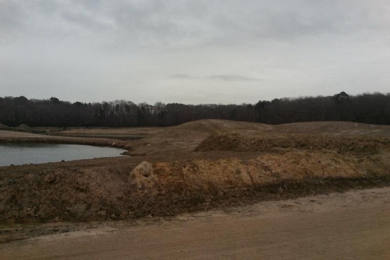
9 Site Photos Page 9

10 Disclosure Statement Page 10
11 Disclosure Statement Page 11
12 Disclosure Statement Page 12
13 Disclosure Statement Page 13

14 Disclosure Statement Page 14
Public Hearing January 13, Request Conditional Use Permit (Auto Repair Garage) Staff Planner Carolyn A.K. Smith
 Staff Planner Carolyn A.K. Smith") Applicant Property Owner Holland Century Associates, LLP Public Hearing January 13, 2016 Request Conditional Use Permit (Auto Repair Garage) Staff Planner Carolyn A.K. Smith Location 3949 Holland Road
Applicant Property Owner Holland Century Associates, LLP Public Hearing January 13, 2016 Request Conditional Use Permit (Auto Repair Garage) Staff Planner Carolyn A.K. Smith Location 3949 Holland Road
Request Conditional Use Permit (Automobile Repair Garage) Staff Planner Jimmy McNamara
 Staff Planner Jimmy McNamara") Applicant Property Owner Sarrow One, LLC Public Hearing December 14, 2016 City Council Election District Princess Anne Agenda Item 13 Request Conditional Use Permit (Automobile Repair Garage) Staff Planner
Applicant Property Owner Sarrow One, LLC Public Hearing December 14, 2016 City Council Election District Princess Anne Agenda Item 13 Request Conditional Use Permit (Automobile Repair Garage) Staff Planner
11 February 13, 2013 Public Hearing APPLICANT& PROPERTY OWNER: EVERGREEN VIRGINIA, LLC
 11 February 13, 2013 Public Hearing APPLICANT& PROPERTY OWNER: EVERGREEN VIRGINIA, LLC STAFF PLANNER: Karen Prochilo REQUEST: Modification of a Conditional Use Permit for motor vehicle sales approved by
5 February 12, 2014 Public Hearing APPLICANT AND PROPERTY OWNER: ERIK HOMES, L.L.C.
 5 February 12, 2014 Public Hearing APPLICANT AND PROPERTY OWNER: ERIK HOMES, L.L.C. STAFF PLANNER: Kristine Gay REQUEST: Special Exception for Alternative Compliance to the Oceanfront Resort District Form-Based
Chapter MINERAL EXTRACTION AND MINING OPERATIONS
 Chapter 17.31 MINERAL EXTRACTION AND MINING OPERATIONS Sections: 17.31.010 Purpose 17.31.020 Procedure for Extraction and Rehabilitation Requests 17.31.030 Operation and Rehabilitation Standards for all
# 5 ) UN THREE CUPS YARD NORTH AMERICA CULTIVATION FACILITY SPECIAL USE PERMIT PUBLIC HEARING
 UN THREE CUPS YARD NORTH AMERICA CULTIVATION FACILITY SPECIAL USE PERMIT PUBLIC HEARING") # 5 ) UN-74-16 THREE CUPS YARD NORTH AMERICA CULTIVATION FACILITY SPECIAL USE PERMIT PUBLIC HEARING STAFF REPORT To: Planning Commission Meeting date: November 9, 2016 Item: UN-74-16 Prepared by: Marc
# 5 ) UN-74-16 THREE CUPS YARD NORTH AMERICA CULTIVATION FACILITY SPECIAL USE PERMIT PUBLIC HEARING STAFF REPORT To: Planning Commission Meeting date: November 9, 2016 Item: UN-74-16 Prepared by: Marc
SP Old Florida Investment Resources, LLC SMR Aggregates SR 64 Borrow Pit (DTS # )
") H.O. 03/24/14 SP-14-01 Old Florida Investment Resources, LLC SMR Aggregates SR 64 Borrow Pit (DTS #201400001) Request: Approval of a Special Permit for major earthmoving in the A (General Agriculture)
H.O. 03/24/14 SP-14-01 Old Florida Investment Resources, LLC SMR Aggregates SR 64 Borrow Pit (DTS #201400001) Request: Approval of a Special Permit for major earthmoving in the A (General Agriculture)
# 17 ) UN DESERT GREEN FARMS SPECIAL USE PERMIT EXTENSION OF TIME PUBLIC HEARING
 UN DESERT GREEN FARMS SPECIAL USE PERMIT EXTENSION OF TIME PUBLIC HEARING") # 17 ) UN-101-14 DESERT GREEN FARMS SPECIAL USE PERMIT EXTENSION OF TIME PUBLIC HEARING STAFF REPORT To: Planning Commission Meeting date: December 9, 2015 Item: UN-101-14 Prepared by: Robert Eastman GENERAL
# 17 ) UN-101-14 DESERT GREEN FARMS SPECIAL USE PERMIT EXTENSION OF TIME PUBLIC HEARING STAFF REPORT To: Planning Commission Meeting date: December 9, 2015 Item: UN-101-14 Prepared by: Robert Eastman GENERAL
11 April 8, 2015 Public Hearing
 11 April 8, 2015 Public Hearing APPLICANT: EAT THE STREETS 757 PROPERTY OWNER: MIKE STANDING REQUESTS: 1. Alternative Compliance to the Oceanfront Resort District Form-Based Code 2. Conditional Use Permit
D1 June 11, 2014 Public Hearing
 D1 June 11, 2014 Public Hearing APPLICANT: VIRGINIA BEACH HORSEBACK PROPERTY OWNER: CHARLIE & ROSEMARY THOMPSON STAFF PLANNER: Kristine Gay REQUEST: Conditional Use Permit (Horses for Hire) ADDRESS / DESCRIPTION:
PLANNED UNIT DEVELOPMENT, PLANNING APPROVAL & SUBDIVISION STAFF REPORT Date: June 4, 2015
 PLANNED UNIT DEVELOPMENT, PLANNING APPROVAL & SUBDIVISION STAFF REPORT Date: June 4, 2015 NAME SUBDIVISION NAME CC Williams Plant Subdivision CC Williams Plant Subdivision LOCATION CITY COUNCIL DISTRICT
Zoning Permits 11-1 ZONING PERMITS
 Zoning Permits 11-1 ZONING PERMITS (a) Building or structures shall be started, repaired, reconstructed, enlarged or altered only after a zoning permit has been obtained from the administrator and a building
Ordinance No Lot Surface Drainage
 Ordinance No. 35-2008 - Lot Surface Drainage The Township has adopted a new Lot Surface Drainage Ordinance which amends Chapter 170, Article IX, Subdivision and Site Plan Review by adding a new Section
SOUTH FLORIDA WATER MANAGEMENT DISTRICT. Question 13: Wetlands
 SOUTH FLORIDA WATER MANAGEMENT DISTRICT Question 13: Wetlands 1. The wetland responses and topographical data provided in the ADA for the 520- acre project site are conceptual in nature. The referenced
WELCOME IL 47. Community Advisory Group Meeting #5 Waubonsee Community College Wednesday, May 31, 2017
 WELCOME IL 47 Community Advisory Group Meeting #5 Waubonsee Community College Wednesday, May 31, 2017 MEETING PURPOSE MEETING AGENDA 1. Welcome/Introduction 2. Review Previous Public Involvement 3. Process/Schedule
Chapter 21 Stormwater Management Bylaw
 Chapter 21 Stormwater Management Bylaw SECTION 1. PURPOSE The purpose of this Bylaw is to: implement the requirements of the National Pollutant Discharge Elimination System (NPDES) General Permit for Storm
APPLICATION FOR PUBLIC INFRASTRUCTURE PERMIT
 APPLICATION FOR PUBLIC INFRASTRUCTURE PERMIT Engineering Division 550 Landa Street New Braunfels, Texas 78130 (830) 221-4020 1. Subdivision Plat Name: Location Description/ Nearest Intersection: Acreage:
TRAFFIC STUDY GUIDELINES
 TRAFFIC STUDY GUIDELINES December 2013 The scope of the traffic impact analysis (TIA) should follow these guidelines and the requirements of VMC 11.80.130 and VMC 11.70, transportation concurrency (attached
APPENDIX B. Public Works and Development Engineering Services Division Guidelines for Traffic Impact Studies
 APPENDIX B Public Works and Development Engineering Services Division Guidelines for Traffic Impact Studies Revised December 7, 2010 via Resolution # 100991 Reformatted March 18, 2011 TABLE OF CONTENTS
Chapter 4. Drainage Report and Construction Drawing Submittal Requirements
 4.0 Introduction The requirements presented in this section shall be used to aid the design engineer or applicant in the preparation of drainage reports, drainage studies, and construction drawings for
LAND USE PBF LDR ZONING PUD PUD. Proposed Maximum Density (DU/Acre) Existing Maximum Intensity (FAR) .30 FAR/ 173 dwelling units.
 Existing Maximum Intensity (FAR) .30 FAR/ 173 dwelling units.") PROPOSED LARGE SCALE FUTURE LAND USE MAP (FLUM) AMENDMENT OVERVIEW ORDINANCE: 2013-658 APPLICATION: 2013G-001-3-5 APPLICANT: PAUL HARDEN PROPERTY LOCATION: On the south side of Sunbeam Road, at the terminus
PROPOSED LARGE SCALE FUTURE LAND USE MAP (FLUM) AMENDMENT OVERVIEW ORDINANCE: 2013-658 APPLICATION: 2013G-001-3-5 APPLICANT: PAUL HARDEN PROPERTY LOCATION: On the south side of Sunbeam Road, at the terminus
# 14 ) ZN AMERICAN DIALYSIS CENTER OF NORTH LAS VEGAS M-2, GENERAL INDUSTRIAL DISTRICT TO M-1, BUSINESS PARK INDUSTRIAL DISTRICT PUBLIC HEARING
 ZN AMERICAN DIALYSIS CENTER OF NORTH LAS VEGAS M-2, GENERAL INDUSTRIAL DISTRICT TO M-1, BUSINESS PARK INDUSTRIAL DISTRICT PUBLIC HEARING") # 14 ) ZN-10-16 AMERICAN DIALYSIS CENTER OF NORTH LAS VEGAS M-2, GENERAL INDUSTRIAL DISTRICT TO M-1, BUSINESS PARK INDUSTRIAL DISTRICT PUBLIC HEARING STAFF REPORT To: Planning Commission Meeting date:
# 14 ) ZN-10-16 AMERICAN DIALYSIS CENTER OF NORTH LAS VEGAS M-2, GENERAL INDUSTRIAL DISTRICT TO M-1, BUSINESS PARK INDUSTRIAL DISTRICT PUBLIC HEARING STAFF REPORT To: Planning Commission Meeting date:
SW-74 SERENOVA PRESERVE SITES 2, 3, 4, 8 MITIGATION PLAN
 SW-74 SERENOVA PRESERVE SITES 2, 3, 4, 8 MITIGATION PLAN BACKGROUND INFORMATION Project SWIM? Aquatic Control? Exotic Control? Mitigation Bank? Type No No No No Mitigation Restoration and enhancement Type
SECTION STORM DRAINAGE DESIGN, GRADING, AND WATER QUALITY TECHNICAL CRITERIA TABLE OF CONTENTS PAGE 402 STORM DRAINAGE DESIGN CRITERIA 400-1
 CITY OF THORNTON Standards and Specifications Revised: October 2012 SECTION 400 - STORM DRAINAGE DESIGN, GRADING, AND WATER QUALITY TECHNICAL CRITERIA TABLE OF CONTENTS PAGE 401 GENERAL PROVISIONS 400-1
iswm TM Criteria Manual City of Azle Section 14 City of Azle Subdivision Ordinance DRAFT-June Chapter 1
 City of Azle Section 14 City of Azle Subdivision Ordinance DRAFT-June 2010... Chapter 1 i CITY OF AZLE iswm CRITERIA MANUAL FOR SITE DEVELOPMENT AND CONSTRUCTION Incorporating the Regional NCTCOG Integrated
NOTICE OF PREPARATION OF AN ENVIRONMENTAL IMPACT REPORT
 Date: September 19, 2017 NOTICE OF PREPARATION OF AN ENVIRONMENTAL IMPACT REPORT To: Agencies and Interested Parties Lead Agency: Sacramento Municipal Utility District 6201 S Street, MS B203 Sacramento,
Section 1 Non-Conforming Structures and Uses Allowed to Continue. 12
 CHAPTER 3 NONCONFORMITIES Section 1 Non-Conforming Structures and Uses Allowed to Continue. 12 Section 2 Discontinuance 12 Section 3 Change of Use... 12 Section 4 Residential Alterations 12 Section 5 Restoration..
Construction Best Management Practices Handbook BEST MANAGEMENT PRACTICES
 Construction Best Management Practices Handbook www.montereysea.org BEST MANAGEMENT PRACTICES 26 www.montereysea.org Construction Best Management Practices Handbook VEHICLE TRACKING AND DUST CONTROL IN
RESOLUTION NUMBER 4162
 RESOLUTION NUMBER 4162 A RESOLUTION OF THE CITY COUNCIL OF THE CITY OF PERRIS, COUNTY OF RIVERSIDE, STATE OF CALIFORNIA, APPROVING MITIGATED NEGATIVE DECLARATION 2274, ALUC OVERRULE AND APPROVAL OF DEVELOPMENT
CHAPTER 6 ADDITIONAL STANDARDS APPLYING TO SHORELAND AREAS AND PUBLIC WATERS
 CHAPTER 6 ADDITIONAL STANDARDS APPLYING TO SHORELAND AREAS AND PUBLIC WATERS Section 1 Intent. 49 Section 2 Floodplain Requirements 49 Section 3 Water-Oriented Accessory Structures 50 Section 4 Stairways,
SECTION 3 DRAINAGE. 3-1 General. 3-2 Drainage Ordinances and Legal Requirements
 SECTION 3 DRAINAGE 3-1 General All Drainage plans for proposed development shall be prepared by a Professional Engineer registered in Virginia, except as noted below. Further, their seal and signature
Florida Department of Environmental Protection. Bureau of Mining and Minerals Regulation. Regulation of Mines. Howard J. Hayes, Program Administrator
 Florida Department of Environmental Protection Bureau of Mining and Minerals Regulation Regulation of Mines Howard J. Hayes, Program Administrator April 2011 What is a mine? Nonphosphate mine: Subsections
DISTRICT OF NORTH VANCOUVER GUIDELINES FOR THE DEVELOPMENT OF CONSTRUCTION TRAFFIC MANAGEMENT PLANS
 DISTRICT OF NORTH VANCOUVER GUIDELINES FOR THE DEVELOPMENT OF CONSTRUCTION TRAFFIC MANAGEMENT PLANS Construction Impact Mitigation Strategy Guidelines for Major Developments The District of North Vancouver
Notwithstanding article VII of this chapter, the following conditional uses may be permitted in the planned mixed use development (PMUD) zone:
 zone:") DIVISION 14. - PLANNED MIXED USE DEVELOPMENT (PMUD) Sec. 78-1021. - Purpose. The town is a community with a rich tradition of mixed use neighborhoods and a paucity of land area dedicated for large commercial,
DIVISION 14. - PLANNED MIXED USE DEVELOPMENT (PMUD) Sec. 78-1021. - Purpose. The town is a community with a rich tradition of mixed use neighborhoods and a paucity of land area dedicated for large commercial,
VDOT Land Use Overview. Brad Shelton, AICP Transportation and Mobility Planning Division June 2015
 VDOT Land Use Overview Brad Shelton, AICP Transportation and Mobility Planning Division June 2015 VDOT Land Development Programs Local/State Plan and Program Consistency Review local comp plan transportation
Review Zone Application for D&R Canal Commission Decision
 Review Zone Application for D&R Canal Commission Decision MEETING DATE: June 15, 2016 DRCC #: 15-4748 Phase I and II Latest Submission Received: May 4, 2016 Applicant: Kevin Hayes Country Club Meadows,
CHAPTER 13 R-5 MANUFACTURED MOBILE HOME PARK RESIDENTIAL DISTRICT
 15.1300 CHAPTER 13 R-5 MANUFACTURED MOBILE HOME PARK RESIDENTIAL DISTRICT 15.1301 SECTION 13.01 STATEMENT OF PURPOSE To provide for manufactured home park development, of long-term duration of stay, in
District of North Vancouver Construction Traffic Management Plan Guidelines
 District of North Vancouver Construction Traffic Management Plan Guidelines The District of North Vancouver is committed to ensuring that the disruptions to the community and traffic associated with construction
PLANNED UNIT DEVELOPMENT & SUBDIVISION STAFF REPORT Date: July 11, 2013
 PLANNED UNIT DEVELOPMENT & SUBDIVISION STAFF REPORT Date: July 11, 2013 SUBDIVISION NAME DEVELOPMENT NAME LOCATION Northside LTD/Joint Venture Subdivision, Resubdivision of and Addition to Lot 3A Northside
COON CREEK WATERSHED DISTRICT PERMIT REVIEW. Spring Lake Park Schools Westwood Middle School st Avenue NE, Spring Lake Park, MN 55432
 PAN 16-112, Westwood Middle School, Page 1 of 6 COON CREEK WATERSHED DISTRICT PERMIT REVIEW MEETING DATE: August 22, 2016 AGENDA NUMBER: 10 FILE NUMBER: 16-112 ITEM: Westwood Middle School RECOMMENDATION:
# 7 ) UN MY PLACE HOTEL SPECIAL USE PERMIT PUBLIC HEARING
 UN MY PLACE HOTEL SPECIAL USE PERMIT PUBLIC HEARING") # 7 ) UN-53-16 MY PLACE HOTEL SPECIAL USE PERMIT PUBLIC HEARING STAFF REPORT To: Planning Commission Meeting date: September 14, 2016 Item: UN-53-16 Prepared by: Marc Jordan GENERAL INFORMATION: Applicant:
# 7 ) UN-53-16 MY PLACE HOTEL SPECIAL USE PERMIT PUBLIC HEARING STAFF REPORT To: Planning Commission Meeting date: September 14, 2016 Item: UN-53-16 Prepared by: Marc Jordan GENERAL INFORMATION: Applicant:
STREAM AND BUFFER AREA PROTECTION/RESTORATION
 STREAM AND BUFFER AREA PROTECTION/RESTORATION AMENDMENT OPTIONS TO STRENGTHEN POLICY IN HEADWATERS AREAS DRAFT SUBSEQUENT TO THE JANUARY 25, 2007 MEETING OF THE PLANNING COMMISSION ENVIRONMENT COMMITTEE
STATE OF MINNESOTA MINNESOTA POLLUTION CONTROL AGENCY
 STATE OF MINNESOTA MINNESOTA POLLUTION CONTROL AGENCY In the Matter of the Decision on the Need for an Environmental Impact Statement for the Proposed Remer Wastewater Treatment Facility Expansion FINDINGS
STORMWATER RUNOFF AND WATER QUALITY IMPACT REVIEW
 SUBCHAPTER 8 STORMWATER RUNOFF AND WATER QUALITY IMPACT REVIEW 7:45-8.1 Purpose and scope of review Except for those projects expressly exempted by this chapter or waived by the Commission, the Commission
MODEL Stormwater Local Design Manual. City of Centerville
 MODEL Stormwater Local Design Manual City of Centerville Adopted December 6, 2005 TABLE OF CONTENTS 1. FORWARD... 1 2. GENERAL LEVEL OF SERVICE STANDARDS... 1 2.1. DETENTION REQUIREMENTS... 1 2.1.1. Discharge
ENVIRONMENT ACT TERMS OF REFERENCE NOVA SCOTIA DEPARTMENT OF TRANSPORTATION AND PUBLIC WORKS. Beaver Bank Bypass
 ENVIRONMENT ACT TERMS OF REFERENCE NOVA SCOTIA DEPARTMENT OF TRANSPORTATION AND PUBLIC WORKS Beaver Bank Bypass Highway 101 to the Beaver Bank Road Halifax County, NS NOVA SCOTIA DEPARTMENT OF THE ENVIRONMENT
Building Permit Applications for new home construction will not be accepted unless the following documentation is included at the time of submission:
 Building Permit Applications for new home construction will not be accepted unless the following documentation is included at the time of submission: Copy of Alberta Government s New Home Registration
UNIVERSITY OF OREGON NORTH CAMPUS CONDITIONAL USE PERMIT PROJECT Draft Conditional Use Permit Stormwater, Sanitary Sewer, and Water Analysis Report
 UNIVERSITY OF OREGON NORTH CAMPUS CONDITIONAL USE PERMIT PROJECT Draft Conditional Use Permit Stormwater, Sanitary Sewer, and Water Analysis Report Prepared for: Cameron McCarthy Landscape Architects LLP
General Permit No.: OHR Page 53 of 146
 Page 53 of 146 Part 8 Sector-Specific Requirements for Industrial Activity Subpart J Sector J Non-Metallic Mineral Mining and Dressing. You shall comply with Part 8 sector-specific requirements associated
Fence and Wall Requirements
 Fence and Wall Requirements Definitions Decorative wall - A wall constructed of stone or other material erected for the sole purpose of providing a decorative and/or landscaped feature, and not to include
City of North Miami Beach, Florida COMMUNITY DEVELOPMENT DEPARTMENT
 City of North Miami Beach, Florida COMMUNITY DEVELOPMENT DEPARTMENT TO: Planning and Zoning Board FROM: Carlos M. Rivero, City Planner DATE: August 10, 2015 RE: Storage Facility P&Z ITEM # 15-010 OWNER
Chapter 7. Street Drainage. 7.0 Introduction. 7.1 Function of Streets in the Drainage System. 7.2 Street Classification
 7. Introduction This chapter summarizes methods to evaluate runoff conveyance in various street cross sections and curb types in the Town of Castle Rock and identifies acceptable upper limits of street
Stormwater Local Design Manual For Houston County, Georgia
 Stormwater Local Design Manual For Houston County, Georgia Adopted November 15, 2005 TABLE OF CONTENTS 1. FORWARD... 1 2. GENERAL LEVEL OF SERVICE STANDARDS... 2 2.1. DETENTION REQUIREMENTS... 2 2.1.1.
3 PROJECT DESCRIPTION
 3.1 PROJECT OVERVIEW 3 PROJECT DESCRIPTION The Rocklin 60 project (proposed project) includes the subdivision of 56.9 acres of land, construction of 179 single-family, detached dwelling units, and installation
Review Zone Application for D&R Canal Commission Decision
 Review Zone Application for D&R Canal Commission Decision MEETING DATE: December 21, 2016 DRCC #: 16-4345 Latest Submission Received: December 7, 2016 Applicant: Robert McCarthy, PE PSE&G 4000 Hadley Road,
PART 3 - STANDARDS FOR SEWERAGE FACILITIES DESIGN OF STORM SEWERS
 PART 3 - STANDARDS FOR SEWERAGE FACILITIES 3.3 - DESIGN OF STORM SEWERS 3.301 Design of Storm Sewers A. General Information B. Investigations and Surveys C. Special Projects 3.302 Design Criteria for Storm
Wetland Permit Application
 DAVID J. KLOTZLE WETLAND INSPECTOR, PHILIPSTOWN, NY 238 Main Street Cold Spring, NY 10516 (914) 736-7132 Wetland Permit Application MEMO TO APPLICANT 1. Use this form to apply for a Wetlands Permit as
GUIDE TO THE DEVELOPMENT OF A MINING AND RECLAMATION PLAN IN NEW BRUNSWICK
 PROVINCE OF NEW BRUNSWICK DEPARTMENT OF ENERGY AND RESOURCE DEVELOPMENT Minerals and Petroleum Development Branch GUIDE TO THE DEVELOPMENT OF A MINING AND RECLAMATION PLAN IN NEW BRUNSWICK Guide to the
RECOMMENDATION: Staff recommends approval and provides the following motion for the commission s consideration:
 PZ Case No. 17-09 Planning & Zoning Commission COMMUNITY DEVELOPMENT DEPARTMENT March 13, 2017 Subject: Consider making a recommendation on PZ Case No. 17-09; the site plans for Amega Garage Doors at 4901
E. STORMWATER MANAGEMENT
 E. STORMWATER MANAGEMENT 1. Existing Conditions The Project Site is located within the Lower Hudson Watershed. According to the New York State Department of Environmental Conservation (NYSDEC), Lower Hudson
LOT GRADING. LOT GRADING REQUIREMENTS The following lot grading requirements came into effect on May 1, 2007:
 LOT GRADING DEFINITION Lot grading is the reshaping or sloping of the land in such a way that surface drainage from rain runoff is directed away from the buildings and is controlled in a manner that eliminates
Project Initiation Form
 Meeting Date: The Project Initiation Form should be completed in conjunction with the Level 2 Screening Form. Process Leads and/or Planners should complete the Project Initiation Form to document coordination
HIGH SCHOOL #2 Severance, CO MANAGEMENT PLAN November,
 HIGH SCHOOL #2 Severance, CO MANAGEMENT PLAN November, 18 2016 1 VICINITY MAP Site Data Land Use Statistics o Proposed Developed Site 55 acres 22.8% o Flood Plain 6 acres 2.4% o Open Space 100.6 acres
Predicting Highway Construction Impacts on a Community
 Predicting Highway Construction Impacts on a Community Making the Best Decisions in the Face of Conflicting Values What does this mean? Roadway elevation Noise Berms or Noise Walls Selective clearing or
PLAN SUBMISSION, BUFFERING AND SETBACK FROM TRANSMISSION PIPELINES
 PLAN SUBMISSION, BUFFERING AND SETBACK FROM TRANSMISSION PIPELINES Note: The sections of this ordinance are intended to be enacted as part of a Township s Subdivision and Land Development Ordinance. AN
6 Preliminary Assessment of Construction Method and Constructability Issues
 6 Preliminary Assessment of Construction Method and Constructability Issues 6.1 Construction Approach Appendix C includes conceptual designs of the alternatives discussed below. Generally, the conceptual
Application for Gas Exploration and Production
 1800 Washington Blvd. Suite 655 Baltimore Maryland 21230 Application for Gas Exploration and Production This application is to be used to obtain a permit to Drill and Operate a well, within the State for
Advisory Planning Commission September 27, 2016 Page 6 of 27
 Page 6 of 27 B. Quarry Road Addition Applicant Name: United Properties Development LLC, Rick McKelvey Location: 1555 Yankee Doodle Road; Application: Rezoning A Rezoning from A, Agriculture to PD, Planned
ADMINISTRATIVE HEARING STAFF REPORT
 ADMINISTRATIVE HEARING STAFF REPORT Salt Lake City Water Treatment Facility 1365 West 2300 North CONDITIONAL USE Case #PLNPCM2013-00762 December 12, 2013 Planning and Zoning Division Department of Community
Project Title: Major Site Review (SR16-06) for Ripon Gardens II Commercial
 for Ripon Gardens II Commercial") Planning Commission Staff Report Planning Commission Hearing November 14, 2016 Project Title: Major Site Review (SR16-06) for Ripon Gardens II Commercial Request: A request to develop a 15,996 square foot
Planning Commission Staff Report Planning Commission Hearing November 14, 2016 Project Title: Major Site Review (SR16-06) for Ripon Gardens II Commercial Request: A request to develop a 15,996 square foot
Fence, Wall & Column Information Packet
 FENCE INFORMATION FROM SECTION 9.13 OF THE PINEHURST DEVELOPMENT ORDINANCE: (1) The purpose of this Subsection is to allow fences within districts which are architecturally compatible with each other,
City of Elgin SUBDIVISION FINAL ENGINEERING Engineering Submittal Checklist
 If this is a re-submittal, please provide a point-by-point response to previous review comments, identifying how each comment has been addressed, location in the plan set of the changes made to address
The rezoning application and proposed transportation facility warrants consideration.
 Date: November 11, 2014 To: Re: Chair and Members Planning & Development Committee PDE File Number: REZ1400020 275 Conception Bay South Bypass Road, Ward 5 Application to Rezone Land to Industrial General
Plan Name Plan No. Submitting Firm Contact Engineer. Review Date ESI Team ENGINEERS AND SURVEYORS INSTITUTE PEER REVIEW CHECKLIST CITY OF ALEXANDRIA
 EROSION AND SEDIMENT CONTROL CHECKLIST (E&S) VIRGINIA EROSION AND SEDIMENT CONTROL HANDBOOK (1 of 2) Item # Description OK NO N/A 1 Limits of clearing and grading match on all appropriate sheets 2 Construction
GRADING & DRAINAGE PERMIT SOIL EROSION AND SEDIMENTATION CONTROL PERMIT PROGRAM OVERVIEW
 GRADING & DRAINAGE PERMIT SOIL EROSION AND SEDIMENTATION CONTROL PERMIT PROGRAM OVERVIEW Chapter 8 Building and Building Regulations, Article XIII Grading and Drainage and Article XV Soil Erosion and Sedimentation
STORMWATER AND EROSION CONTROL PERMIT
 STORMWATER MANAGEMENT AND EROSION CONTROL PERMIT INSTRUCTIONS AND INFORMATION Any project that involves the disturbance of ANY quantity of land requires the applicant to receive approval for the project
Executive Summary June 24, EXECUTIVE SUMMARY. 1.1 Introduction
 1.0 EXECUTIVE SUMMARY 1.1 Introduction This Draft Environmental Impact Statement (DEIS) has been prepared in response to a Positive Declaration issued by the Town of Bedford Planning Board in connection
NEW CASTLE CONSERVATION DISTRICT. through. (Name of Municipality) PLAN REVIEW APPLICATION DRAINAGE, STORMWATER MANAGEMENT, EROSION & SEDIMENT CONTROL
 PLAN REVIEW APPLICATION DRAINAGE, STORMWATER MANAGEMENT, EROSION & SEDIMENT CONTROL") NEW CASTLE CONSERVATION DISTRICT through (Name of Municipality) PLAN REVIEW APPLICATION DRAINAGE, STORMWATER MANAGEMENT, EROSION & SEDIMENT CONTROL Office use only: Received by Municipality: Received by
NEW CASTLE CONSERVATION DISTRICT through (Name of Municipality) PLAN REVIEW APPLICATION DRAINAGE, STORMWATER MANAGEMENT, EROSION & SEDIMENT CONTROL Office use only: Received by Municipality: Received by
Stormwater Management Technical Manual
 Public Works Department Stormwater Management Technical Manual October 2015 HillsboroughCounty.org PREFACE The following text contains current information for designing and submitting construction plans
Chapter 3 Dispersion BMPs
 Chapter 3 Dispersion BMPs 3.1 BMP L611 Concentrated Flow Dispersion 3.1.1 Purpose and Definition Dispersion of concentrated flows from driveways or other pavement through a vegetated pervious area attenuates
PUBLIC HEARING LOOP 9
 PUBLIC HEARING LOOP 9 From Interstate (I)-35E to I-45 Dallas and Ellis Counties, Texas CSJ: Loop 2964-10-005 9: I-35E to I-45 Tuesday, June 20, 20, 2017 2017 Public Hearing Introductions ELECTED & PUBLIC
Stormwater Management Studies PDS Engineering Services Division ES Policy # 3-01
 Stormwater Management Studies PDS Engineering Services Division Revised Date: 2/28/08 INTRODUCTION The City of Overland Park requires submission of a stormwater management study as part of the development
Currituck County Moyock Mega-Site Market Feasibility Study March 28, 2016
 Currituck County Moyock Mega-Site Market Feasibility Study March 28, 2016 Presentation Outline Project Background Demographic and Economic Data Review Competitive Market Analysis Feasibility Assessment
CITY OF TACOMA RIGHT-OF-WAY RESTORATION POLICY. Guidance on restoration of City Rights-of-Way
 CITY OF TACOMA RIGHT-OF-WAY RESTORATION POLICY Guidance on restoration of City Rights-of-Way Public Works Department Directors Office 747 Market Street Suite 408 Tacoma, WA 98402 253-591-5525 Right-of-Way
Draft Environmental Assessment Terminal B/C Redevelopment, Secure National Hall, and Related Improvements
 JUNE 2016 RONALD REAGAN WASHINGTON NATIONAL AIRPORT Draft Environmental Assessment Terminal B/C Redevelopment, Secure National Hall, and Related Improvements PREPARED BY: Ricondo & Associates, Inc. IN
Before we get to the E&SC
 Erosion and Sedimentation Control on Mine Sites Ashley Rodgers, PE Assistant Regional Engineer NC DENR DEMLR RRO Before we get to the E&SC There are major differences in the application and review process
ARTICLE 5 RESIDENTIAL MANUFACTURED HOME DISTRICT. Description and Purpose CHARTER TOWNSHIP OF BRIGHTON ZONING ORDINANCE
 ARTICLE RESIDENTIAL MANUFACTURED HOME DISTRICT This Article was reviewed and approved by the Michigan Department of Consumer and Industry Services, Corporation and Securities Bureau, Manufactured Home
Assessment of Landfill Footprint Alternatives West Carleton Environmental Centre. Option #4 Impact on Agriculture
 Assessment of Landfill Footprint Alternatives Figure 422 99 Option #4 Impact on Agriculture The net effects with respect to continued service to customers, the optimized site life/ capacity is 65 million
Attachment 1 Findings and Conditions
 2451 Ridge Road Use Permit #04-10000066 Attachment 1 Findings and Conditions APRIL 10, 2008 CEQA FINDINGS 1. The project is categorically exempt from the provisions of the California Environmental Quality
SOLID WASTE FACILITY PERMIT
 1. Name and Street Address of Facility: 2. Name and Mailing Address of Operator: 3. Name and Mailing Address of Owner: West County Integrated Resource Recovery Facility Central Processing Facility 101
TABLE OF CONTENTS 4.17 UTILITIES AND SERVICE SYSTEMS...
 TABLE OF CONTENTS 4.17 UTILITIES AND SERVICE SYSTEMS... 4.17-1 4.17.0 Introduction... 4.17-1 4.17.1 Methodology... 4.17-2 4.17.2 Existing Conditions... 4.17-2 4.17.3 Impacts... 4.17-4 4.17.4 Applicant-Proposed
FINDING OF NO SIGNIFICANT IMPACT OWL CREEK GRAVEL PIT EXPANSION U.S. FOREST SERVICE
 FINDING OF NO SIGNIFICANT IMPACT OWL CREEK GRAVEL PIT EXPANSION U.S. FOREST SERVICE OURAY RANGER DISTRICT OURAY COUNTY, COLORADO BACKGROUND The Owl Creek Gravel Pit, also known as the Spruce Ridge Pit,
EXECUTIVE SUMMARY ES.1 BACKGROUND ES.2 PURPOSE AND NEED FOR THE PROPOSED PROJECT
 EXECUTIVE SUMMARY ES.1 BACKGROUND The purpose of this Draft Environmental Report (DEIR) is the implementation of improvement projects at Charles M. Schulz Sonoma County Airport (the Airport). The improvement
Application Number: SP Project Name: Novo Nordisk Bright Sky Major Site Plan (acting as a Master Plan)
") STAFF REPORT Town of Clayton Staff Report Planning Department 111 E. Second Street, Clayton, NC 27520 P.O. Box 879, Clayton, NC 27528 Phone: 919-553-5002 Fax: 919-553-1720 Planning Board February 22, 2016
STAFF REPORT Town of Clayton Staff Report Planning Department 111 E. Second Street, Clayton, NC 27520 P.O. Box 879, Clayton, NC 27528 Phone: 919-553-5002 Fax: 919-553-1720 Planning Board February 22, 2016
Municipal Stormwater Management Planning
 Municipal Stormwater Management Planning Christopher C. Obropta, Ph.D., P.E. Water Resources Extension Specialist with Rutgers Cooperative Extension Assistant Professor with Department of Environmental
Ingham County Drain Commissioner Patrick E. Lindemann 707 BUHL AVENUE P. O. BOX 220 MASON MI PH. (517) FAX (517)
 FAX (517)") Date Issued Ingham County Drain Commissioner Patrick E. Lindemann 707 BUHL AVENUE P. O. BOX 220 MASON MI 48854 PH. (517) 676-8395 FAX (517) 676-8364 APPLICATION FOR SOIL EROSION AND SEDIMENTATION POLLUTION
Date Issued Ingham County Drain Commissioner Patrick E. Lindemann 707 BUHL AVENUE P. O. BOX 220 MASON MI 48854 PH. (517) 676-8395 FAX (517) 676-8364 APPLICATION FOR SOIL EROSION AND SEDIMENTATION POLLUTION
CITY OF VIRGINIA BEACH CITY CODE APPENDIX E TREE PLANTING, PRESERVATION AND REPLACEMENT*
 City of Virginia Beach, VA City Code / Zoning Ordinance Abstracted January 2008 http://www.vbgov.com/file_source/dept/mcg/web%20page/hot%20topics/gree nribboncommittee/documents/naturalresourcemanagementsubcommittee/appen
Environmental Information Worksheet
 Environmental Information Worksheet Water System Owner (Attach additional sheets if necessary) Needs and Alternatives Provide a brief narrative that describes: Current drinking water system needs. Project
Administrative Hearing Staff Report
 Administrative Hearing Staff Report CenturyLink Utility Boxes 175 N A St Conditional Use PLNPCM2013-00320 Public Right-of-Way at approximately 165-175 North A St Hearing date: July 11, 2013 Planning Division
The City of North Las Vegas (CNLV) does not allow valley gutters to be constructed across streets with right-of-way widths of 80 feet or greater.
 does not allow valley gutters to be constructed across streets with right-of-way widths of 80 feet or greater.") Background The City of rth Las Vegas strives to provide the development community with adequate information to ensure the successful completion of any project in the City. To aid in the submittal of a
Background The City of rth Las Vegas strives to provide the development community with adequate information to ensure the successful completion of any project in the City. To aid in the submittal of a