Red Salmon Slough Restoration Project Phase 3 Lessons Learned
|
|
|
- Jody Stevenson
- 6 years ago
- Views:
Transcription
1 Red Salmon Slough Restoration Project Phase 3 Lessons Learned Overall: This project entailed two major elements to continue the work of Red Salmon slough restoration. The surge plain forest restoration revegetated the lands along the inter-tidal river and just above salt marsh elevation, and the design of the last dike removal in the slough. Two biologist with the Nisqually Tribe worked on these elements. Lessons were gained during the process on how to do it best, what to consider and what not to do. Lesson learned during planting projects: Overall this was an easy place to plant, and survival of planted plants is extremely high, well over 90%. The site included fertile soils with sub-irrigation due to the numerous springs and tidal influence. We prepared the site using various techniques, i.e. disking, plowing, and herbicide treatments, which were mostly meant to reduce grass competition in this former pasture. The extensive site prep made for easy and trouble-free planting especially by the numerous volunteers and school children. After the planting was completed, 2 foot tree protection tubes were used, which seemed to have helped with the high survival of the plants. It made for easier post-planting mowing and herbicide treatments since the plants were protected and more visible. It was a learning experience to plant this close to saltwater and with year-round water influence on the site. Micro site conditions varied drastically due to sun, shade, groundwater influence, freshwater and saltwater influence. Planting each species at a time was very successful since we were able to respond by matching each species preferred growing conditions to those micro conditions. Very high winter tides in the area conincided sometimes with the preferred planting times, and made access to the site very difficult at times. Dike removal design: We contracted most of the design work to Wiltermood Associates Inc. and much of the engineering drawings were completed by them and their sub-contractors. A few lessons that were learned was mostly in the form of getting a better understanding of the site conditions, such as soil conditions, it s history: how were those dikes built, for what purpose, and new regulatory hurdles such how to fill wetlands to make them better and how to close of a county road temporarily.
2 Red Salmon Slough Restoration Project Phase 3 Dike Removal design Goal: To activate and improve on-going passive restoration at the Red Salmon Slough area by enhancing hydrologic connections to surrounding water bodies, removing artificial structures that constrict tidal currents and/or impair water quality, and by restoring any impacted areas to known historic conditions. Obj.1 Enhance hydrologic connection to surrounding water bodies by removing 6700 feet of river dike and slough entrance dike and reconnect at least three (3) historic independent Red Salmon sloughs. Obj.2 Remove the Red Salmon Slough creosote bridge, any other creosote pilings and fill at least 1000 feet of accessible remnants ditches. Obj.3 Restore historic vegetation in project disturbance area, i.e. footprint and fill areas in approximately 2.5 acres. Alternatives: Passive Restoration (do nothing) Alternative Advantage: Low cost, natural evolution if historic processes are in place Disadvantage: Very long timeline for recovery ( years), unnatural evolution if historic processes are not place, risk of invasive species, Phase 3 Restoration Advantage: short time for recovery (1-100 years), lower risk for invasive species due to higher intensity of management and habitat form manipulation, assist with restoring more natural/historic processes Disadvantages: Potentially changing evolutionary process due to manipulation, some shortterm impact Full restoration of anthropogenic structures Description: Same as Phase 3 restoration plus restoring all straightened ditches including less accessible and biologically functioning ditches. It would also include complete removal of site access road. Advantage: same as Phase 3 alternative Disadvantages: High impact on site; no private and public access for PR and monitoring efforts.
3 Site-specific limitations/uncertainties Some of the site specific limitation to implementing the project and uncertainties are: 1. Reliance on passive restoration The project restarts the habitat-forming processes and not the habitat forms and it is relying on the passive restoration to do most of the work. Although this is the preferred way to restore habitat, if the process are not restored correctly, evolution might not progress as smoothly and anticipated. Estuaries very dynamic systems and therefore it is hard to predict the exact outcome of any project. In addition, the 700 acre refuge restoration is being implemented at the same time, which dwarfs Red Salmon Slough and will ultimately have an impact on not just the refuge itself but it surrounding area. It is uncertain how this large project will affect this phase of the Red Salmon slough project, although it does have the potential to divert the entire river away from the slough project and therefore make the environment more saline, less river influenced and less dynamic. 2. Challenging site conditions for construction work Navigating heavy machinery in wetlands is very delicate work. Operating heavy machinery in wetlands with tidal fluctuations is a daunting task. While working in such conditions, compromises have to be made to achieve the goals, and complete them safe and with limited impact to the environment. Predictions of tide height, that determines the construction schedule, are not 100% temporally and spatially accurate. Although many areas seem to support construction equipment, in actuality the substrate will not and therefore adjustments need to be made. Also, Phase 3 does not have large interior pasture sites that make access and staging of equipment easy. Instead we are removing dikes with sensitive areas on both sides that restrict movement considerably. 3. Upland/vs. intertidal vegetation restoration Actively restoring upland vegetation to prevent invasive plant establishment on the footprint of the dikes will be a difficult task. Any areas that support salt marsh habitat will be left to passive recolonization, but areas above that will be replanted to provide historic riparian habitat. The salinity sensitivity of native woody estuary vegetation will make the exact extent of the plantings hard to define. In most areas for this phase, the salinity will not be determined by the tide height, but by the dynamics of the Nisqually River freshwater pathways. This could result in changes in suitability of these locations over many months.
4 Rationale for alternative The Phase 3 alternative will provide the goals and objectives with the less impacts than the full restoration, more certainty than the do-nothing alternative, and still will let the restored processes do most of the restoration. Phase 3 alternative is not proposing to fill every straightened and dug channel on the east side of the slough due to existing functioning habitat within and surrounding those channels. The full alternative would fill those naturalized ditches, which would have a higher impact on site with little extra benefit, and uncertainty about navigation of heavy machinery in established salt marsh. The only other human impact / structure that won t be addressed it the access road. We won t restrict our access road since we will need to continue accessing the site for monitoring, adaptive management, and environmental education and public relations purposes. The road might also serve as a public access in the future and will serve the cause much more remaining in place than the minor benefit reaped from removing it. The implementation of the chosen alternative will have to include close supervision to ensure changes to the plan can be made when unexpected situations arise. We are planning on almost 100% construction supervision by a project biologist, with the authority to adjust elements of the project. Extent and nature of treatments of preferred alternative To achieve the goal and the above-mentioned three objectives, this project will include these action items: Obj.1 Enhance hydrologic connection to surrounding water bodies by removing 6700 feet of river dike and slough entrance and reconnect at least three (3) historic independent Red Salmon sloughs. Action #1: Remove the river dikes by excavating to a common elevation for either side and either remove all fill material completely or leave some behind thinly spread or mounded as riparian planting surfaces. Action #2: Reconnect the low point in the Phase 1 restoration site with a channel to the riverine tidal channel guided by historic conditions. Action #3: Remove the Red Salmon Slough entrance dikes common elevation and reconnect obvious tidal channels on either side. Obj.2 Remove the Red Salmon Slough creosote bridge, any other creosote pilings and fill at least 1000 feet of accessible remnants ditches. Action #1: Remove the remnants of the collapsed Red Salmon slough bridge, including all creosote pilings and dispose of the material properly at the Hawks Prairie Landfill. Cap any pilling holes will clean sand.
5 Action #2: Remove the old hay barn / highway sign made of creosote dispose of the material properly at the Hawks Prairie Landfill. Action #3: Fill at least 1000feet of accessible remnant ditches on the east side of the project area. Reconnect obvious tidal channel through this area but do not fill every single ditch due to low benefit/high impact to surrounding salt marsh ratio to fill every ditch in that area. Use dike material, if clean, to fill the ditches. Obj.3 Restore historic vegetation in project disturbance area, i.e. footprint and fill areas in approximately 2.5 acres. Action #1: Replant any area that is projected to be freshwater riparian, guided by reference conditions nearby. Overplant and assume some loss to salt water. Action #2: Let natural re-colonization of native salt marsh species take over areas below presumed freshwater riparian habitat elevation Predictions We predict that achieving Objective 1 will allow for more frequent tidal inundation from the river with freshwater rather than the highly saline water from Red Salmon Slough. This will initiate changes in the composition of salt marsh species and allow for more freshwater tolerant species to colonize the restoration areas. An increase in sedimentation is also to be expected due to the closer connection with the river that supplies the suspended sediment that is needed for marsh surface accretion. In addition, a distributary could potentially form through the Red Salmon Slough, which would be the first true distributary channel from the Nisqually River in the delta. This would most likely happen during a high tide connected with a flood event, and could happen rather quickly and not in a slow progression over months and years. The improved connection to the lower Red Salmon Slough due to removal of the dikes on the east side of the slough could potentially increase tidal penetration into the slough, increase sedimentation and tidal channel network in the marshes downstream of the dike and increase sheet flow and marsh accretion upstream. We predict that the vegetation we plant on the footprint of the dike will take some time to establish until annual tide and river flow cycles will provided the exact conditions for the native species. Some species will not survive and others will thrive, since it will be hard to predict exact inundation level, frequency and salt content. Salt marsh will be recruited within the first 3 years and we predict that most conducive areas will be covered within less than 10 years. Hypotheses
6 Several hypotheses could test the prediction through monitoring. These three we find particular interesting and potentially useful for adaptive management: 1. Will removal of the dike change the salt content of tidal prisms and therefore increase the diversity of salt marsh species in Red Salmon Slough? 2. Will the tidal prism increase in volume in Red Salmon Slough? 3. Will the fish and wildlife species utilization change due to the change in hydrologic conditions in Red Salmon Slough?
7 Red Salmon Slough Restoration Project - Phase 3 Riparian Re-vegetation Design Surge Plain Re-vegetation Conceptual Design Report This portion of the project will restore 50+ acres of rare salt/fresh transitional forest ( Surge Plain ) at the upper edge of tidal inundation along the Nisqually River and Red Salmon Slough. Goal 1. Re-establish a diverse self-sustaining native forest and shrub-scrub plant community on 50+ acres of surge plain riparian habitat at the Nisqually Tribe s property along Red Salmon Slough, Nisqually River, and associated tidal marsh. Objectives 1. Plant 750 native trees and shrubs per acre over 50+ acres 2. Increase diversity of native species in the surge plain habitat 3. Plant appropriate plant species for the various hydrologic regimes at the site (wetlands and uplands both present with brackish influence at the lowest elevations) 4. Maintain the planting site for 3 years 5. Ensure successful establishment of at least 600 trees/shrubs per acre after 3 years, and 400 trees/shrubs per acre after 10 years Alternatives 1. Passive restoration No actions taken a. Advantages Low/no cost b. Disadvantages Passive restoration is unlikely to achieve project goals in a reasonable amount of time. Extreme competition form well established pasture grasses would likely inhibit woody plant establishment for many year to come. This approach would likely also result in a relatively low diversity plant community of only the most vigorous and prolific pioneer species, with other later successional species taking decades to establish. 2. Introduce disturbance then passive restoration A treatment of using a combination of tilling and disking and/or herbicide application to disturb the site and allow colonization of native woody species from adjacent forested areas. a. Advantages Low cost b. Disadvantages This treatment would run a high risk of colonization by invasive undesirable species and a high degree of uncertainty that a diverse community of native species would colonize the site due to the
8 lack of adequate seed sources and/or species specific seed dispersal limitations. 3. Full planting (trees) This approach would involve controlling grass competition as site preparation with plowing and disking and/or herbicide use and planting trees across the entire site. After the trees are established other native understory species would colonize. a. Advantages Moderate cost, reestablish some ecosystem processes, would establish site on a trajectory to full recovery faster than passive restoration b. Disadvantages The main disadvantage would be that many of the appropriate shrub species would be slow to colonize and others are not locally present to colonize the site. There is also a greater risk that invasive species would colonize the understory. 4. Full planting (trees & shrubs)* - Control grass competition through plowing/disking and/or herbicide application. Plant 50+ acres with a diverse assemblage of native trees and shrubs. Provide maintenance for 3-5 years (competition control). There will possibly be some minor herbaceous plantings in discrete areas as determined by site conditions. a. Advantages Reestablish wide range of ecosystem processes and structures. Provides high quality habitat for a diverse array of species. Provides a diverse assemblage of woody species. Restores natural sediment transport processes and nutrient cycling. b. Disadvantages Moderate cost 5. Full planting (trees, shrubs, and herbaceous species) Control grass competition through plowing/disking and/or herbicide application. Plant 50+ acres with a diverse assemblage of native trees, shrubs, and appropriate herbaceous species. Provide maintenance for 3-5 years (competition control). a. Advantages Most complete option as far as restoring native species assemblages, fully restoration of ecosystem processes, b. Disadvantages Very high cost, hard to maintain woody species and control competition with desirable herbaceous species in understory. Preferred alternative* Spatially explicit site specific factors affecting achievement of goals and uncertainties A variety of site specific factors have the potential to influence the achievement of project goal, objectives, and overall success. These include grass competition with woody species, hydrology of the site, flooding from the river, browse and girdling from ungulates/rodents, and the influence of tidal action and potential saline influence. Future sea-level rise is another concern that may affect the project in the longer term.
9 Each of these uncertainties and ways to mitigate them are discussed below. Grass competition Competition for water, light, and nutrients between planted woody species and herbaceous species (especially rhizomatous pasture grasses) can greatly impede the success of plantings. The past land use at the site (livestock pastures) encouraged a pasture-grass dominated vegetation community that has the potential to impact the success of the woody plantings. This uncertainty will be managed by performing adequate site preparation to reduce pasture grasses and manage competing vegetation for three years to ensure the successful establishment of the intended woody plant community. Herbivory Damage to woody plantings due to both browse by ungulates and damage from rodents can impact the success of planting projects. There are ungulates in the area that have the potential to impact woody plantings, but it is not likely to be of an intensity to affect overall project success. Potential impacts from rodent activity are a much larger risk at this site. Beaver are established in adjacent wetlands and active on the edges of the site along I-5. There is also a large population of small rodents that currently inhabit the site largely due to past land use and favorable habitat. They can girdle young woody plants at the base causing high levels of mortality. These risks will be managed by placing plant protection around all woody plantings at the site. These will provide a physical deterrent to both beaver and small rodent activity. Mowing of the site or other methods to reduce cover for small rodents will also discourage their activity. Hydrology The hydrology of the site in general and at specific locations within the site has a large influence on which species of woody plants are appropriate and will establish at a given location. This site has a particularly complex array of hydrologic influences. There is a large spring fed wetland complex on the eastern edge of the site that provides significant fresh water inputs to the site through out the year. The tidally influenced Nisqually River runs along the western edge of the site. Its water level fluctuates depending on combination of tides and river flow and has the potential to flood over the entire site during wet season flood events. The tidal influence extends to the northern edge of the planting area. This adds additional complexity as predicting an exact line of tidal influence and matching appropriate salt tolerant woody species to the various elevations can be tricky. Sea level rise The planting area being entirely on low lying lands skirting the upper level of saline influence will be susceptible to future sea level rise. Over time the plant community will likely evolve to adapt to changes in tidal and sealevel changes. Establishing a diverse resilient native plant community will help the system adjust to future changes in sea level, by providing a buffer of woody vegetation between the marine environment, tidal salt marsh, tidal freshwater marsh, and adjacent infrastructure (I-5).
10 Preferred Alternative Details Site preparation Reduce the influence of existing introduced pasture grasses at the site and prepares the site for planting. This will be accomplished by a combination of tillage and/or herbicide treatment. Any herbicide use will be with aquatic approved herbicide and adjuvant. An aquatic approved formulation of glyphosate and an aquatic approved surfactant will be applied to the site with broadcast spray equipment. All herbicide will be applied by a licensed applicator with aquatic endorsement during the dry season. The site may be plowed and disked after the herbicide treatment to further prepare the site for planting. Planting 50+ acres will be planted with native woody species. The plant materials will be a mixture of trees and shrubs that are appropriate for the various hydrologic regimes and the potential for brackish tidal influence. This work will occur over two planting seasons with roughly half the area planted each year. A minimum of 750 plants per acre will be installed. There are two primary target habitats at the site - uplands that are only inundated when the river floods and wetlands which are a combination of freshwater wetlands fed by springs along the eastern edge of the site and to the east of I-5, and wetlands that are fed by ground water and rainfall along the central and western portions of the site. All along the northern edge of the site interaction with brackish water is another factor in species selection. Species on the wetland plant list were selected for salt tolerance and can stand some level of brackish influence during extreme winter high tides. This are is the trickiest to plan for as recent dike removals have altered hydrology and tidal prism and site conditions continue to evolve and equilibrate. The strategy we have chosen is to plant slightly into the brackish areas and let the plants adjust to their preferred zones. Table 1. Trees (33%) 225/ac Malus fusca (crabapple) Fraxinus latifolia (Oregon ash) Alnus rubra (red alder) Salix lucida (Pacific willow) Picea sitchensis (Sitka spruce) Trees (50%) 387/ac Acer macrophyllum (big-leaf maple) Prunus emarginata (bitter cherry) Populus balsamifera (cottonwood) Alnus rubra (red alder) Thuja plicata (red cedar) Picea sitchensis (Sitka spruce) Frangula purshiana (cascara) Wetlands - Salt-Fresh Transition Forested Wetland (~22.5 acres) Shrubs (66%) 550/ac Salix hookeriana (Hooker's willow) Rosa pisocarpa (Swamp rose) Salix sitchensis (Sitka willow) Myrica gale (sweet gale) Loinicera involucrata (twinberry) Uplands - Surge Plain Forest (~22.5 acres) Shrubs (50%) 388/ac Oemlaria cerasiformis (Indian plum) Physocarpus capitatus (ninebark) Sambucus racemosa (red elderberry) Symphoricarpus albus (snowberry) Rubus spectabalis (salmonberry) Salix scouleriana (Scoulers willow) Acer circinatum (vine maple)
11 Plant materials will be a combination of 1-gallon containers for volunteer plantings (approximately 8000), bare-root plant materials (approximately 18500), and live-stakes (approximately 10000). The volunteers will be recruited from a variety of sources including public week end events, targeted group events (i.e. Intel, Ft Lewis), and school groups (3 rd grade through high school). The bare-root and live-stake plants will be primarily installed by a crew of Nisqually tribal members. Species to be planted are listed in Table 1. Small trial plantings of herbaceous species may be included in this work if site conditions are favorable. This may include sedges and/or rushes that may not have local seed sources to re-establish viable populations and are important cultural plants for Tribal members. The existing forested wetland systems along the river, the Nisqually National Wildlife Refuge across the river, and other local tidal fringe plant communities were used as reference sites to determine appropriate plant species and elevations. Protection In order to protect the plantings from damage by beavers, small rodents, and to some extent ungulates - tree tubes will be installed around all woody plantings. These will consist of 18 recycled plastic tubes secured to the ground with 24 wooden stakes. The tubes will also help to protect the plants from damage that may result from maintenance activities (mowing/vegetation management) and help them to remain visible for monitoring activities. The tubes will be removed and recycled after three to five years when the plants are established. Maintenance Managing competing vegetation is planned to occur for three years after plant installation to ensure that the plants get a good start and are not out competed by weeds and/or pasture grasses. Mechanical control and spot herbicide treatments are both being considered as options to manage competing vegetation and invasive species at the site. Predict how the proposed action will result in changes to structures processes and functions and what factors external to, prior to, or subsequent to the action will affect that prediction Changes to Site Structure, Function, and Processes Structures The 45-acre planting site will change from a pastured agricultural area dominated by introduced pasture grasses with no woody cover to a multi-layer forested community dominated by a diverse array of native woody species including. Small plantings or seeding of native emergent plants may be installed as appropriate. Maintaining the plantings for a period of three years will greatly improve the likelihood of successful establishment.
12 Over time the site will develop into three distinct habitats: upland riparian forest, forested wetlands, and scrub-shrub wetland. Small areas along the fringes may develop into emergent wetland or high salt marsh depending on tidal actions, sea level rise, and hydrologic changes at the site. Since this site is still in active recovery from recent dike removals, has a complex hydrologic regime influenced by beaver activity, is slightly above the current tidal prism, and is in the active river deposition and meander zones - it will continue to evolve over the long term. Re-establishing the historic woody plant community will allow the site to be more resilient while also providing greatly improved habitat for a broad array of fish and wildlife species. Processes Woody Debris Recruitment As the planted riparian vegetation matures wood will become available as debris that can be recruited into the estuary. The current pasture condition does not provide a source of wood for Red Salmon Slough, Nisqually River Estuary, and adjacent nearshore. Adequate maintenance to ensure the survival of the planted tree species will be critical to providing a source of woody debris. Shade The plantings along the river will increase the shading of the channel and help to moderate channel temperatures in the lowest reach of the river. The wetland areas of the site will also benefit from the shade provided by the forest and shrub-shrub plant community as well as any future tidal channels that may form in the transition zone. Erosion/Sediment Transport Restoring the surge plain forest will allow natural erosion and deposition processes to re-establish. These processes will facilitate the rebuilding of tidal marsh elevations in adjacent tidal marsh restoration that has been subject to subsidence, as well as supplying an additional source of sediment to build marsh elevations in the adjacent Nisqually National Wildlife Refuge restoration project. Litterfall/Nutrients Re-establishing forested conditions at the site will restore natural nutrient cycling and litter fall in a habitat is directly adjacent to the estuary. Restoring these processes will help provide food web support and nutrients to the estuary. Carbon Storage Woody vegetation will provide longer term carbon storage than the pastures that currently exist at the site. Restore Habitat Forming Processes Restoring the surge plain habitat to a forested condition will re-establish a wide range of habitat forming processes. These processes will allow the surge plain and delta to be a dynamic system where natural disturbance regimes are allowed to create diverse habitats that will benefit a wide range of species. Functions Providing a functional riparian buffer for the Nisqually River, Red Salmon Slough and tidal marsh is the primary function of this project. Establishing woody vegetation across the site will provide the various functions listed below.
13 Food Chain Support The organic matter and litterfall provided by the target plant community will provide nutrients to support the food web at the site and adjacent estuary. Water Quality The proposed actions will provide improved water quality function that will benefit the adjacent Nisqually River, Red Salmon Slough, and estuary when compared to the prior condition as livestock pasture. Noise Buffer As it matures the woody plant community will provide a buffer from the noise of I-5, which runs directly adjacent to the site. This will allow wildlife to utilize the site without the disturbance of observing vehicles on the highway and lower decibel levels along the river and estuary. These changes should improve the utility of the site for wildlife and allow greater use. Habitat Linkages - Restoring both linkages of the upland/aquatic ecotone and of the saltwater/freshwater ecotone because it is riparian and well as forested transition habitat will increase the value of the site. Identify opportunities to answer questions important for improving capacity of regional restoration planning or design via monitoring. There are a number of interesting questions that can be answered while restoring the native woody plant community at this site. The first being: at what elevations can various species of woody plants survive adjacent to a tidal salt marsh? This question can be answered by planting a range of woody species at the edge of tidal influence and monitoring to see which will survive limited exposure to brackish water. This information will be helpful in determining the appropriate elevations for woody plantings on other surge plain re-vegetation projects. Another question that can be answered is: What management/maintenance actions are most successful at establishing native woody plantings in former agricultural fields?
14 Construction Sequence for project actions 2007 Summer Fence Removal Late Summer Site Preparation Early Fall Layout Fall Volunteer Plantings Fall/Early Winter Live Stake Plantings 2008 Winter Bare-Root Plantings and Protection Installation Early Spring Finish Plant Protection Installation Spring/Early Summer Seedling Release Mowing or Spraying Summer Mowing and Monitoring Late Summer Site Preparation for Second Phase Fall Volunteer Plantings Late Fall/Early Winter Live-Stake Planting 2009 Winter Bare-Root Planting and Protection Installation Early Spring Finish Plant Protection Installation Spring/Early Summer Seedling Release Mowing or Spraying and Herbaceous Plantings (if determined appropriate) Summer Mowing and Monitoring 2010 Summer Mowing and Monitoring 2011 Summer Mowing and Monitoring
15


16 Planting, Maintenance and Monitoring Plan for Nisqually Basin Riparian Re-vegetation Projects Nisqually Indian Tribe Department of Natural Resources Salmon Recovery Program Technical Report No. 3 Florian Leischner Jeanette Dorner June 2004
17 Maintenance and Monitoring Plan for Nisqually Basin Riparian Re-vegetation Projects 1. Introduction Lack of a mature and healthy riparian buffers along streams is a major limiting factor to healthy aquatic ecosystems. Riparian vegetation provides various attributes such as shade, input of organic debris, bank stabilization and others, which influences fish and especially salmon habitat. Re-planting native vegetation in previous cut riparian forests is a major tool to restore depressed salmon runs in the Nisqually River Basin and other Pacific Northwest basins. Although only native and site appropriate vegetation will be replanted, it is important to monitor and maintain the seedlings to ensure successful establishment. This Plan will outline appropriate a monitoring and maintenance (m&m) regime which will ensure high survival for riparian re-vegetation. It will also act as a log book to track any riparian plantings and m&m efforts in the Nisqually River basin. 2. Planting Goals and Methods Goal The goal for riparian planting projects is to restore the natural riparian buffer along stream that has been altered in the past. Alteration can range from complete eradication of any plants to selective or past logging that has diminished the desired riparian species. The most desired species are, in most case, a wide array of shrubby species, and tree species typical for the treatments site. Planting methods Several ready available guides describe and illustrate methods and techniques of setting up and implementing a riparian planting. This chapter will only explain Nisqually basin specific methods and considerations. Plant protection Depending on budget available for the project is desired to include Plant Protection Tubes for most plants. These tubes protect the seedlings from wildlife damage, provides the seedling with a hard shell that protects it from being engulfed by competing plants and at the same time acts as a mini greenhouse. It also protects the plants from being cut by mowers or weeding equipments used in maintenance efforts. Studies have shown that these tubes significantly increase the growth and survival of newly planted seedlings. These tubes, stay on medium to large trees until the tree trunk destroys the by then bridle plastic. The tubes on small trees or shrubs should be removed after 3-5 years when the plant has outgrown competing grasses and the danger of animal browse has significantly decreased. If the budget for a planting project does not allow for 100% of plants to be tubes it is recommended tubes these plant groups in order of importance: 1. Coniferous trees 2. Large decidous trees (rooted) 3. Small deciduous trees and shrubs (rooted) 4. Large deciduous trees (live stakes) 5. Small deciduous trees and shrubs (live stakes) 6. Rhizomatous shrubs (i.e. Nootka Rose; Snowberry, Oregon grape, etc.)
18 Planted ground cover, grasses, rushes or sedges should never be tubed. It is also recommened to use full tubes rather than rolled and stapled tubes due to their lesser need of maintenance and durability. Passive Weed control To keep competitive weeds and grasses away from the planted tree or shrub, various weed control methods can be employed. Before planting, weeds and grasses should be mechanically or chemically treated to give the seedlings a few years of advantage over the competing plants. At planting time, weed mats or mulch should be laid out around the plants to give the plant the competitive advantage. Mulch should not be employed if the area has a high flood risks. If the budget for a planting project does not allow for 100% of plants to be matted, it is recommended that these plant groups should be matted, in order of importance: 1. Coniferous trees 2. Large decidous trees 3. Small deciduous trees and shrubs (rooted) 4. Large deciduous trees (live stakes) 5. Small deciduous trees and shrubs (live stakes) Planted ground cover, grasses, rushes, sedges, and rhizomatous shrubs (i.e. nootka rose; snowberry, etc.) should not be matted since it will impede the proliferation of the plant. Plastic weed mats do not need to be removed after establishment, since they will break down after several years, especially they are not covered with mulch. Prairie ecosystems A large part of the Nisqually basin is part of the South Puget Sound Praire ecosystem that function differently than most western Washington lowland forest ecosystems. The riparian vegetation community is different than along other rivers, and the soils are distinctly different, excessively drained and poor in nutrients. Reed Canary grass is very prevalent along many of these streams due to the prairie stream run-off regime. Due to the disadvantages conditions along these streams, survival and growth will most likely be lower than other streams. Special care should be taken when planting along these streams to insure high success and establishment rates. 3. Maintenance Monitoring To enumerate success of the planting, monitoring should occur once a year during the late spring months (preferable May, when no maintenance is needed and most plants are not dormant anymore). Monitoring is an integral component of adaptive management, which will lead to better decision-making about planting projects in the future. Key components of adaptive management are: 1. Identifying indicators for ecological functions and habitat values 2. Setting measurable objectives for the indicators 3. Planning and implementing actions 4. Monitoring the indicators 5. Evaluating the measurable objectives and reporting results and 6. Revisiting and altering rules and laws of implementations. Our indicator is plant survival, which is the main data point that needs to be collected during monitoring procedures. Our objectives are: 80% first year survival and 70% three year establishment rate of the total number of plants In prairie streams, it is 80% first year and 60% three year establishment of the total number of plants
19 The annual monitoring procedure will include a tally of the alive vs. dead plants by species, number of stressed plants, and if possible, measurement of growth on all or some of the species. Maintenance needs and time commitment needed should be recorded at the same time or at an initial walk-through. Reporting occurs through annual monitoring report sheet (see appendix 1) for each planting site. These reports will be helpful for the maintenance staff as well as the analysis of meeting the objectives. After three years the plant is considered established and needs no more regular maintenance, although periodically the site should still be monitored. This include visual inspection of all plant condition and check for maintenance needs of the planting site. Maintenance methods Maintenance of planting can be accomplished using a variety of methods depending on the needs and condition of a site. The three main elements of that the seedling need to survive to establish them selves is sunlight and water and nutrients. The first will be provided by planting them the appropriate way and protecting them with tree shelters (see above). Competing grasses and weeds that might shade the plant will be passively surpressed by the weed mats, but in many cases also needs to be actively managed and controlled. The surrounding weeds and grasses also compete for nutrients and therefore needs to be controlled in the early years. The need for additional nutrients (i.e. fertilizer) is considered a non-issue since the species selection should be adapted to the natural availability of nutrients. It also might promote the growth of competing vegetation if not applied properly. Irrigation is also needed to be supplemented during the first several establishment years, especially in the summer months. The lack of water is probably the leading cause of non-establishment / early mortality in planted seedlings and should be avoided above all else. Active weed control Competing weeds and grasses can actively be controlled by various methods appropriate for the site. These surpressive methods include: chemical control, physical control through mowing, trimming, cutting or trampling, or biologically through grazing, etc. Each method has its dis- and advantages and is more appropriate at some sites than at another. Chemical control is expensive and requires care not to negatively affect the surrounding environment, i.e. existing beneficial vegetation and water quality. It is highly effective for noxious and nuisance weeds such as reed canary grass, non-native blackberry shrubs, or poison hemlock. If uniform stands of such weeds are encountered, it is recommended to treat those chemically before plantings begin. After riparian plants are planted it is only recommended if treatment will not compromised those plants. The easiest physical control of weeds and grasses is mowing the grass at least once during the growing cycle. During the first summer, and at places where weeds are dominated by fast growing grasses (e.g. reed canary grass) the areas should be mowed at least twice during the growing cycle to keep them from competing with the plants. The mowing can be accomplished using a lawnmower, brush mower, weed eater, or even hedge shears. Care should be taken that only the grass is cut not the planted native trees and shrubs. Trampling can be effective if the grasses are high enough to break once stepped on. It requires a lot of labor and is less effective than mowing. Grazing is an option if livestock is in the area and the plant large or it is protected from trampling or grazing damage. It is and especially easy way of preparing a site for plantings in the fall months before the grasses and weeds have disappeared. Livestock can compact sensitive soils and should only be used before a planting and after several years after the planting and if water quality can be protected at the same time. Irrigation During the first year after planting it is critical that the planted trees and shrubs get watered. Irrigation can occur starting in May and last until October. The objective is to supply the plant with enough water through the normal rainfall or through irrigation that each plant receives 4 inches of water per month. During the middle of the summer, the Nisqually basin receives almost no precipitation and all the water needs need to be addressed through irrigation.
20 The second year, the plant should be more established and more deeper root network to supply its water needs by itself. Irrigation should still be applied to ensure 2 inches of month throughout the May to October growing season. During the final and last year of maintenance, the plants should still be irrigated to ensure 1 inch of rainfall to the plant each month. On average, all months except July and August do provide enough rainfall to reach that goal. 4. Idealized Schedule Monitoring Walk-through Early May ; check for maintenance needs Survival goal 80 % establishment rate 1st Year 2nd year 3rd year 4th+ Year Early May ; check for maintenance needs Min.70% survival rate Early May ; check for maintenance needs Min. 70% survival (60% in prairie) not needed Planting report Maintenance Mowing Very important; at least two times Important; at least once Once before growing cycle Watering 4+ inches 2+ inches 1+ inch Others Ensure tubes Ensure tubes Ensure tubes are still in place are in place are in place Start removing tubes 5. Record keeping In the Appendix of this document a separate section for each planting in the Nisqually River Basin should be provided. Each section includes a RIPARIAN PLANTING DATA SHEET and a seperate RIPARIAN PLANTING MAINTENANCE SHEET for each year. The beginning of the appendix should include a table that chronological lists all plantings in the Nisqually River watershed. The RIPARIAN PLANTING DATA SHEET included information about the planting; i.e. the planting plan. This includes: general information about the site, a sketch of the planting site with sections, dates of when each section was planted, the species and type of protection used in each section. The RIPARIAN PLANTING MAINTENANCE SHEET needs to be filled out each May during the intial walk-through and information will be provided on: maintenance and monitoring needs, special considerations, and work and monitoring performed. After three years the planting chapter should include a one-page end report which will show if and how the goals and objectives were achieved and if additional work is needed after the 3-year period.
21 Appendix A
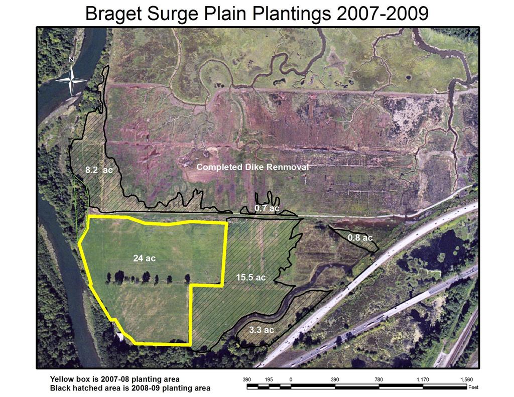
22 Revegetation As-built design Red Salmon Slough Restoration Project Phase 3 Total Braget March Surge Plain Plantings 30 ac 24 ac total = 54 ac Acer circinatum (vine maple) Acer macrophyllum (big-leaf maple) Alnus rubra (red alder) Cornus sericea Corylus cornuta (Crataegus douglasii )black hawthorne 0 60 Fraxinus latifolia (Oregon ash) Loinicera involucrata (twinberry) Malus fusca (crabapple) Oemlaria cerasiformis (Indian plum) Myrica californica (wax myrtle) Physocarpus capitatus (ninebark) Picea sitchensis (Sitka spruce) Pinus contorta (shore pine) Populus blasamifera (cottonwood) Psuedotsuga menzisii (Doug. Fir) Rhamnus purshiana (cascara) Ribes divaricatum (swamp gooseberry) Rosa nutkana (Nootka rose) Rosa pisocarpa (Swamp rose) Rubus spectabalis (salmonberry) Salix hookeriana (Hooker's willow) Salix sp (Pacific/Sitka willow) Salix scouleriana (Scoulers willow) Sambucus racemosa (red elderberry) Spirea douglasii (spirea) Symphoricarpus albus (snowberry) Thuja plicata (red cedar) Tsuga hertophylla (Western hemlock) Vaccinium ovata (evergreen hucklberry) 0 90 Totals


23 Feb 2008 after planting of yellow area:

24 August 2008: Summary: From 2007 to 2009 over 41,000 plants were planted as part of the Red Salmon Slough Restoration Project Phase 3. This planting is restoring over 54 acres of critical surge plain forest habitat in the Nisqually Estuary. With a combination of tribal crews and volunteers, 30 different species of native shrubs and trees were planted using a variety of plant stock type, including live cuttings, bare-root plants and potted plants. Almost all plants are being protected from grass mowing operations and from the large rodent population in the former pasture with the help of temporary plastic tubes. Besides mowing, grass and weed competition is being surpressed using chemical means.


25 Nisqually Indian Tribe crew: February 2009: Volunteer planting event November 2008:
Cromwell Park Wetland Mitigation Year 3 Summer Monitoring
 Cromwell Park Wetland Mitigation Year 3 Summer Monitoring October, 2013 Prepared for: Brian Landau Surface Water and Environmental Services Program Manager City of Shoreline Public Works Department 17500
SR 161: Jovita Boulevard to South 360th St. Stage 2 / WSDOT Stream Buffer Mitigation (Agreement Y-9403) 2012 Final Monitoring Report
 2012 Final Monitoring Report") 2012 SR 161: Jovita Boulevard to South 360th St. Stage 2 / WSDOT Stream Buffer Mitigation (Agreement Y-9403) 2012 Final Monitoring Report SR 161: Jovita Boulevard to South 360th St. Stage 2 (MP 31.95 to
2012 SR 161: Jovita Boulevard to South 360th St. Stage 2 / WSDOT Stream Buffer Mitigation (Agreement Y-9403) 2012 Final Monitoring Report SR 161: Jovita Boulevard to South 360th St. Stage 2 (MP 31.95 to
Heron Glen Wetland Buffer Enhancement Project. Progress Report. November 15, 2005
 Heron Glen Wetland Buffer Enhancement Project Progress Report November 15, 2005 Summary of Activity Since Last Report (August 2004) Weed Control There were few Scots broom (Cytisus scoparius) plants that
PUGET SOUND NEARSHORE ECOSYSTEM RESTORATION
 PUGET SOUND NEARSHORE ECOSYSTEM RESTORATION APPENDIX E MONITORING AND ADAPTIVE MANAGEMENT Integrated Feasibility Report and Environmental Impact Statement This page was intentionally left blank to facilitate
RESTORATION EVALUATION PLAN
 RESTORATION EVALUATION PLAN Project Name: Ramsey Refugia Project Project Proponent: Columbia Slough Watershed Council Project Goal (the overall intent of the habitat restoration effort; in some cases,
Jessica Shaw Agricultural Technician Washington State University Whatcom County Extension Suite 201 Bellingham, WA
 Agricultural Waterway Buffer Study Whatcom County, Washington 202 Authors: Chris Benedict Regional Extension Specialist Washington State University Whatcom County Extension Suite 20 Bellingham, WA 98225
Making Pasture Weed Control Decisions
 Making Pasture Weed Control Decisions Rocky Lemus 1 and Jason Weirich 1 Extension Forage Specialist Visit us at http://msucares.com/crops/forages/index.html As we approach spring growth, weed control becomes
Stewardship Plan instructions REN Capstone 2010
 Stewardship Plan instructions REN Capstone 2010 due May 14 th, 2010 as a Word document to TA & CD to client The stewardship plan (SP) is the project site owner s manual for clients and their designated
2017 Agricultural Water Quality Workshop
 2017 Agricultural Water Quality Workshop Focus Area Lower Lewis and Clark Clatsop SWCD has identified this area as one that needs much improvement This does not mean we can t do projects in other areas
SILVICULTURE SILVICULTURE 10/8/2018. Ecological forestry (Ecosystem management)
") SILVICULTURE SILVICULTURE Dave Peterson University of Washington School of Environmental and Forest Sciences Thanks to Kristi McClelland, Boyd Evison, and Greg Ettl Silviculture The science and art of
SILVICULTURE SILVICULTURE Dave Peterson University of Washington School of Environmental and Forest Sciences Thanks to Kristi McClelland, Boyd Evison, and Greg Ettl Silviculture The science and art of
Logan River at Rendezvous Park, Channel and Floodplain Restoration: Crack Willow (Salix fragilis) Issues and Management Strategies
 Issues and Management Strategies") Logan River at Rendezvous Park, Channel and Floodplain Restoration: Crack Willow (Salix fragilis) Issues and Management Strategies Prepared May 2, 2017 by Darren Olsen, BIO-WEST, Inc. Issues Crack willow
Logan River at Rendezvous Park, Channel and Floodplain Restoration: Crack Willow (Salix fragilis) Issues and Management Strategies Prepared May 2, 2017 by Darren Olsen, BIO-WEST, Inc. Issues Crack willow
Funding Guidelines State Fiscal Year 2016
 State Fiscal Year 2016 Water Quality Financial Assistance Centennial Clean Water Program Clean Water Act Section 319 Program Stormwater Financial Assistance Program Washington State Water Pollution Control
Restoration of Riparian Forests and Riparian Ecosystem Processes and Implications for Salmon Restoration. Katie Ross-Smith Jennifer Hammond
 Restoration of Riparian Forests and Riparian Ecosystem Processes and Implications for Salmon Restoration Katie Ross-Smith Jennifer Hammond Outline > Background California riparian communities Riparian
APPENDIX A. KEY RIPARIAN FUNCTIONS, SUPPORTING VEGETATIVE CONDITIONS, AND RIPARIAN BUFFER DESIGN CONSIDERATIONS
 APPENDIX A. KEY RIPARIAN FUNCTIONS, SUPPORTING VEGETATIVE CONDITIONS, AND RIPARIAN BUFFER DESIGN CONSIDERATIONS Riparian functions Provide shade to keep water cool. Stabilize stream bank to prevent erosion.
Society of Wetland Scientists/ Association of State Wetland Managers Joint Regional Conference, Portland, OR, September 18, 2008
 Reestablishing a Riverine Wetland Using Integrated Pest Management to Control Reed Canarygrass and Reference Wetlands Design Criteria to Restore Structure, Functions, and Habitat-Forming Processes Society
NJDEP Regulations that impact or soon will impact agricultural operations. April 1, 2007 Horses 2007
 NJDEP Regulations that impact or soon will impact agricultural operations. April 1, 2007 Horses 2007 Peter L. Kallin, Ph.D., P.W.S. Phone: 732-499-3600 Ext. 237 E-mail: pkallin@aesop.rutgers.edu www.water.rutgers.edu
Title 92 ROADSIDE VEGETATION MANAGEMENT POLICY
 Title 92 Chapters: ROADSIDE VEGETATION MANAGEMENT POLICY Chapter 92.04 - ROADSIDE VEGETATION MANAGEMENT Chapter 92.04 Sections: ROADSIDE VEGETATION MANAGEMENT 92.04.010 ROADSIDE MAINTENANCE. 92.04.020
GSP Monitoring Team Baseline Data Report
 GSP Monitoring Team The data in this report was gathered by the Green Seattle Partnership Forest Monitoring Team, a citizen-science program that collects information on permanent plots in Seattle s public
CHAPTER 1. Ecological Integrity
 CHAPTER 1 Ecological Integrity RIPARIAN RESTORATION ECOLOGICAL INTEGRITY This chapter suggests a broad interpretation of the riparian ecosystem and its influences. Often riparian ecosystems are described
Forest Stewardship Plan
 Forest Stewardship Plan Effective plan date: June 1, 2002 Forestry is the art and science of managing forest lands and their related resources, including trees and other plants, animals, soil, water, and
Wetland and Stream Sensitive Areas Study for Buffer Reduction Parcels and -0178, Lake Forest Park, WA
 March 10, 2017 Darin Seader 2301 NE Perkins Way Lake Forest Park, WA 98155 AOA-4800 SUBJECT: Wetland and Stream Sensitive Areas Study for Buffer Reduction Parcels 866590-0181 and -0178, Lake Forest Park,
General Riparian Vegetation Concepts. General Riparian Vegetation Concepts WHY?
 General Riparian Vegetation Concepts General Riparian Vegetation Concepts Riparian vegetation is important because: It Stabilizes streambanks with extensive root systems. Shades the water Improves water
Wetland and Stream Sensitive Areas Study Boundary Line Adjustment/Reasonable Use Parcels and -0178, Lake Forest Park, WA
 March 10, 2017 Darin Seader 2301 NE Perkins Way Lake Forest Park, WA 98155 AOA-4800 SUBJECT: Wetland and Stream Sensitive Areas Study Boundary Line Adjustment/Reasonable Use Parcels 866590-0181 and -0178,
streams Taking Care of
 lder Red-osier dogwood Black cottonwood Salmonberry Devils club Sitka spruce Douglas-fir Elderberry Swamp rose Western hemlock Oregon ash Western redcedar Pacific ninebark Willow Recreationist s Guide
Stand Dynamics and Health. Helping Your Woods Grow. For most of us this is our goal. Traditional Land Knowledge. Forest Function and Wildlife Habitat
 Helping Your Woods Grow the art and science of silviculture Stand Dynamics and Health Kristi McClelland, King County DNRP Forester http://cru.cahe.wsu.edu/cepublications/eb2000/eb2000.pdf Photo by John
The Science Behind Forest Riparian Protection in the Pacific Northwest States By George Ice, Summer 2004
 The Science Behind Forest Riparian Protection in the Pacific Northwest States By George Ice, Summer 2004 Riparian buffers, streamside management zones, and similar measures are essential parts of forest
I-405 Congestion Relief and Bus Rapid Transit Projects: Renton Nickel Improvement Project (Renton Stage 1) Mitigation Site USACE NWP
 Mitigation Site USACE NWP") I-405 Congestion Relief and Bus Rapid Transit Projects: Renton Nickel Improvement Project (Renton Stage 1) Mitigation Site USACE NWP 2006-00097 Northwest Region 2016 MONITORING REPORT Wetlands Program
I-405 Congestion Relief and Bus Rapid Transit Projects: Renton Nickel Improvement Project (Renton Stage 1) Mitigation Site USACE NWP 2006-00097 Northwest Region 2016 MONITORING REPORT Wetlands Program
Appendix D Wetland and Stream Photographs
 Appendix D Wetland and Stream Photographs WETLAND PHOTOS Wetland 5-1: north end of wetland in I-5 right-of-way (ROW), looking south. Himalayan blackberry is overgrowing wetland; scattered willows and
Western Oregon Forest Ecology. Michael Ahr, Forest Conservationist
 Western Oregon Forest Ecology Michael Ahr, Forest Conservationist Outline Geology Forest Types Common NW Tree Species Successional Stand Types Brief History of Forest Management Effects on NW Ecosystems
Principles of Forest Ecology and Management. Forensic Forestry Reading the Land. Jonathan Kays University of Maryland Extension
 Principles of Forest Ecology and Management or Forensic Forestry Reading the Land Jonathan Kays University of Maryland Extension jkays@umd.edu Where Do We Start? Think Like A Plant Act Like A Plant Thinking
Middle Wind River Riparian Enhancement Project. Presented by
 Middle Wind River Riparian Enhancement Project Presented by Tova Cochrane & Jamie Gomez Overview (1) Who we are: Underwood Conservation District. (2) Project Description: History, site description, goals
Duwamish Waterway Self Guided Tour: Turning Basin Number Three and Terminal 105 Aquatic Habitat Restoration Sites
 Duwamish Waterway Self Guided Tour: Turning Basin Number Three and Terminal 105 Aquatic Habitat Restoration Sites Text and illustrations in the following pages include: (1) summary information describing
Willamette Special Investment Partnership PRE-APPLICATION Funds Requested $199, Total Project Cost $ $250,000.00
 Willamette Special Investment Partnership I. GENERAL INFORMATION PRE-APPLICATION -2013 Funds Requested $199,590.00 Total Project Cost $ $250,000.00 Round to nearest dollar Round to nearest dollar Name
Habitat Restoration of Garoutte Prairie: 2016 Annual Report
 Habitat Restoration of Garoutte Prairie: 2016 Annual Report 3/31/2017 Report prepared for the Bureau of Land Management, Agreement #L13AC00098 Report prepared by Anna Ramthun and Andy Neill Institute for
ANNUAL REPORT SHILLAPOO WILDLIFE AREA BPA Project #:
 ANNUAL REPORT SHILLAPOO WILDLIFE AREA BPA Project #: 2003-012-00 Prepared for: Joe Deherrera Bonneville Power Administration Prepared by: Brian Calkins Wildlife Area Manager Washington Department of Fish
RIPARIAN FOREST BUFFER
 RIPARIAN FOREST BUFFER (Acres) Code 391 Natural Resources Conservation Service Conservation Practice Standard I. Definition An area predominantly of trees and shrubs that functions as a vegetated ecotone
Maintaining Riparian Areas and Wetlands
 Maintaining Riparian Areas and Wetlands Riparian areas are the lands along the banks of our rivers, lakes, and tidal waters. Many riparian areas not only border surface waters, but they are often adjacent
SW-74 SERENOVA PRESERVE SITES 2, 3, 4, 8 MITIGATION PLAN
 SW-74 SERENOVA PRESERVE SITES 2, 3, 4, 8 MITIGATION PLAN BACKGROUND INFORMATION Project SWIM? Aquatic Control? Exotic Control? Mitigation Bank? Type No No No No Mitigation Restoration and enhancement Type
Mechanical Site Preparation
 Mechanical Site Preparation 1 Mechanical Site Preparation Introduction...3 CONTENTS The Benefits of Guidelines...3 Considerations...5 Design Outcomes To Maintain Soil Productivity...6 Planning...7 Planning
Forensic Forestry Reading the Land
 Principles of Forest Ecology and Management or Forensic Forestry Reading the Land Jonathan Kays University of Maryland Extension Where Do We Start? Think Like A Plant Act Like A Plant Thinking and Acting
Project Started in 1990 on the Ron Risdal Farm. Ron Risdal
 Project Started in 1990 on the Ron Risdal Farm Ron Risdal Before/After on Specific Sites (1990-1994) Before/After on Specific Sites (1990-1994) Buffers On Lon Strum Farm Before Before Riparian Management
Wetland Restoration Using Native Plants. Tara Luna Montana Natural Heritage Program 1515 E.6 th Ave Helena, MT
 Wetland Restoration Using Native Plants Tara Luna Montana Natural Heritage Program 1515 E.6 th Ave Helena, MT http://nhp.nris.mt.gov/ Restoration: Conserving Diversity Species of Concern inhabiting rich
Therriault Riparian Revegetation 2008 Monitoring Report Task Order #0803
 Therriault Riparian Revegetation 2008 Monitoring Report Task Order #0803 Prepared for: Kootenai River Network P.O. Box 491 Libby, MT 59923 Prepared by: Geum Environmental Consulting, Inc. 307 State Street
Conifer restoration on the Duncan-Lardeau Flats Wildlife Properties. January 2006
 Conifer restoration on the Duncan-Lardeau Flats Wildlife Properties January 2006 Prepared for Columbia Basin Fish and Wildlife Compensation Program 333 Victoria Street Nelson, B.C. Prepared by Brenda Herbison,
King County Monitoring Memo, February 2018
 Grass control outperforms watering for increasing the growth and survival in black cottonwood (Populus balsamifera L. spp. trichocarpa) stakes in pasture grasses on the Cedar River, WA (2017 Results) King
INVASIVE SPECIES CONTROL PLAN FOR CONSTRUCTION ACTIVITIES AND POST CONSTRUCTION MONITORING
 INVASIVE SPECIES CONTROL PLAN FOR CONSTRUCTION ACTIVITIES AND POST CONSTRUCTION MONITORING INTRODUCTION Black Oak Wind Farm, LLC is proposing to develop a wind-powered electric generating facility (the
Planning Field Shelterbelts for the Prairies
 Planning Field Shelterbelts for the Prairies Page 1 INTRODUCTION Properly planned field shelterbelts provide many benefits to the agricultural community. The main benefit is wind reduction; shelterbelts
Shannon Claeson USDA Forest Service, PNW Research Station, Olympia, WA Olympic Knotweed Working Group Nov 16, 2011
 Shannon Claeson USDA Forest Service, PNW Research Station, Olympia, WA sclaeson@fs.fed.us Olympic Working Group Nov 16, 2011 Perennial Dense monocultures Moist soil, partial sunlight Disturbed sites (rivers,
Forest Characteristics. Integrating Forest Management and Wildlife. Effects of Silvicultural Practices. Management of Succession
 Forest Characteristics Integrating Forest Management and Wildlife Site descriptors such as aspect, elevation, and soil types Site Index a way of describing the productivity of the site Sam Jackson Nov.
CLIMATE CHANGE AND FOREST BIODIVERSITY: A VULNERABILITY ASSESSMENT AND ACTION PLAN FOR NATIONAL FORESTS IN WASHINGTON
 CLIMATE CHANGE AND FOREST BIODIVERSITY: A VULNERABILITY ASSESSMENT AND ACTION PLAN FOR NATIONAL FORESTS IN WASHINGTON USDA Forest Service, Pacific Northwest Region Carol Aubry, Forest Geneticist, Olympic
North Creek Forest. Shannon Leigh Kehoe BES 398 June 2014
 Monitoring restoration success: Evaluating plant species survival rates at North Creek Forest Shannon Leigh Kehoe BES 398 June 2014 Introduction Ecological restoration is a critical response to environmental
dnr.wa.gov/sflo Planting Forest Seedlings How to select, plant and care for tree seedlings WASHINGTON STATE DEPARTMENT OF Natural Resources
 dnr.wa.gov/sflo Planting Forest Seedlings How to select, plant and care for tree seedlings WASHINGTON STATE DEPARTMENT OF Natural Resources Species and Stock Type It is highly recommended that you get
Scientific Literature Review of Forest Management Effects on Riparian Functions for Anadromous Salmonids
 Scientific Literature Review of Forest Management Effects on Riparian Functions for Anadromous Salmonids Presentation to: The California State Board of Forestry and Fire Protection Prepared by: Mike Liquori
Protection of Rangeland and Pastures from Wildfire
 Protection of Rangeland and Pastures from Wildfire Grazing lands are subject to wildfire because of an abundance of fine fuel (grass), frequent dry conditions, and proximity to an ignition source -usually
Tree Retention Plan LAKE STEVENS, WASHINGTON GROUP FOUR JOB #
 LAKE STEVENS, WASHINGTON GROUP FOUR JOB #05-8027 GROUP FOUR, Inc. 16030 Juanita-Woodinville Way NE Bothell, WA 98011 FAX (206) 362-3819 (425) 775-4581 (206) 362-4244 L116-1 Nourse Lake Stevens, Washington
Proposed Wildlife Habitat Restoration Project At Walking Iron Wildlife Area August 6, 2015
 Proposed Wildlife Habitat Restoration Project At Walking Iron Wildlife Area August 6, 2015 Walking Iron County Wildlife Area is 898 acres situated in the Town of Mazomanie between Walking Iron County Park
Summary of Management Recommendations
 Location and Description This property is owned by Anthony Day, 14426 NW 83 rd Lane, Alachua, FL 32615. The property is located in Section 18, Township 1 North, Range 6 East, in eastern Jefferson County,
I-5/Mellen Street to Blakeslee Junction (Horseshoe Lake) Mitigation Site USACE IP NWS
 Mitigation Site USACE IP NWS") I-5/Mellen Street to Blakeslee Junction (Horseshoe Lake) Mitigation Site USACE IP NWS-2009-1211 Southwest Region 2018 MONITORING REPORT Wetlands Program Issued March 2019 Environmental Services Office
I-5/Mellen Street to Blakeslee Junction (Horseshoe Lake) Mitigation Site USACE IP NWS-2009-1211 Southwest Region 2018 MONITORING REPORT Wetlands Program Issued March 2019 Environmental Services Office
Appendix A (Project Specifications) Patton Mill Fuel Break Project
 Patton Mill Fuel Break Project") Appendix A (Project Specifications) Patton Mill Fuel Break Project I. Proposed Actions: A. Construct a Fuel Break (approximately 5 miles, about 120 acres): The fuel break is located along a segment of
Appendix A (Project Specifications) Patton Mill Fuel Break Project I. Proposed Actions: A. Construct a Fuel Break (approximately 5 miles, about 120 acres): The fuel break is located along a segment of
5.15 Wetlands and Other Waters of the U.S.
 I-70 East Final EIS 5.15 Wetlands and Other Waters of the U.S. 5.15 Wetlands and Other Waters of the U.S. This section discusses wetlands, open waters, and other waters of the U.S. in the study area and
SEPA Environmental Checklist Mercer Island Center for the Arts. Attachment I Tree Assessment
 SEPA Environmental Checklist Mercer Island Center for the Arts Attachment I Tree Assessment January 2017 Bruce Lorig Director Mercer Island Center for the Arts P.O. Box 1702 Mercer Island WA 98040 RE:
R & E Grant Application 13 Biennium
 R & E Grant Application 13 Biennium Project #: 13-111 Project Information R&E Project $4,715.00 Request: Match Funding: $5,400.00 Total Project: $10,115.00 Start Date: 9/15/2015 End Date: 6/30/2015 Project
BLOCKING AND FILLING SURFACE DRAINAGE DITCHES
 MINNESOTA WETLAND RESTORATION GUIDE BLOCKING AND FILLING SURFACE DRAINAGE DITCHES TECHNICAL GUIDANCE DOCUMENT Document No.: WRG 4A-1 Publication Date: 10/14/2015 Table of Contents Introduction Application
Final Operation, Maintenance, Repair, Replace, and Rehabilitate Manual
 Final Operation, Maintenance, Repair, Replace, and Rehabilitate Manual Howard Hanson Dam 1135 Fish & Wildlife Restoration Project Howard Hanson Dam, Washington 1. INTRODUCTION This document outlines the
Implementation of Act 162 of 2014 Riparian Buffer or Riparian Forest Buffer Offsetting
 Implementation of Act 162 of 2014 Riparian Buffer or Riparian Forest Buffer Offsetting March 11, 2015 Dial-in number for Audio: 1-877-668-4493 Access code: 642 373 389 WebEx Technical Support: 866-229-3239
Chapter 10 Natural Environment
 Chapter 10 Natural Environment Existing Conditions The Natural Environment Element addresses the protection, conservation, preservation, and restoration of the natural resources the Bayview Ridge Subarea,
Wetland Ecology Basic Principles. November 14, Kendra Moseley, Regional ESS, Soil Science Division
 Wetland Ecology Basic Principles November 14, 2018 - Kendra Moseley, Regional ESS, Soil Science Division Wetland Ecology Primary & Secondary Succession Disturbance Ecological Thresholds Ecological Dynamics
Riparian Buffer Plantings. Image: Virginia Outdoor Foundation
 Riparian Buffer Plantings Image: Virginia Outdoor Foundation A riparian buffer is land next to a river, stream, or creek that is usually vegetated with trees or shrubs, and acts as a protective filter
Example Forest Health Sections (Resource Category 1)
") Example Forest Health Sections (Resource Category 1) Forest Health Example 1 General Health Insects and diseases: No major forest health problems associated with insects or diseases were observed. Environmental
Example Forest Health Sections (Resource Category 1) Forest Health Example 1 General Health Insects and diseases: No major forest health problems associated with insects or diseases were observed. Environmental
Agency Organization Organization Address Information. Name United States Department of Agriculture
 Logo Department Name United States Department of Agriculture Agency Organization Organization Address Information Forest Service Pacific Northwest Region 1220 SW Third Avenue (97204) P.O. Box 3623 Portland,
City of Eugene IPM and its Implementation on 3 Projects. Eric Wold and Jesse Cary-Hobbs City of Eugene Parks and Open Space Division
 City of Eugene IPM and its Implementation on 3 Projects Eric Wold and Jesse Cary-Hobbs City of Eugene Parks and Open Space Division IPM Policy and Operations Manual 1. Available at www.eugene-or.gov/posipm
Voluntary Water Quality Conservation Plan
 Voluntary Water Quality Conservation Plan Plan Table of Contents A. Mid Coast Agricultural Water Quality Management Area Rules and Plan Overview B. Landowner Resource/Practice Inventory C. Recommended
The Importance of Riparian Forests
 The Importance of Riparian Forests By Jean Llewellyn Monroe County is the second fastest growing county in Pennsylvania. This rapid growth can be problematic because uncontrolled and unregulated growth
Our environment contains a variety of
 The Environmentally Friendly Horse Our environment contains a variety of plants, animals and aquatic life. Each species has a unique role within the environment, and, as a result, each relies on the other
MUKILTEO URBAN FOREST ASSESSMENT EXECUTIVE SUMMARY
 MUKILTEO URBAN FOREST ASSESSMENT EXECUTIVE SUMMARY The trees or more specifically the urban forests of Mukilteo are an integral part of the community. They provide many values to the community, such as
PROSPECTUS. Proposed Beech River Canal Wetland and Stream Mitigation Bank
 PROSPECTUS Proposed Beech River Canal Wetland and Stream Mitigation Bank INTRODUCTION This prospectus provides an overview of Beech River Farms, LLC s (BRF) proposed Beech River Canal Wetland and Stream
MISSOULA CONSERVATION DISTRICT 2018 COST-SHARE APPLICATION
 MISSOULA CONSERVATION DISTRICT 2018 COST-SHARE APPLICATION 3550 Mullan Road, Suite 106 Missoula, MT 59808-5125 Phone: (406) 829-3395 x 101 Email: info@missoulacd.org Website: www.missoulacd.org OFFICE
Background. AEM Tier 2 Worksheet Stream & Floodplain Management. Glossary
 AEM Tier 2 Worksheet Stream & Floodplain Management Glossary Bankfull Stage: The stage at which water starts to flow over the flood plain; the elevation of the water surface at bankfull discharge. (This
R085XY189TX Very Shallow PZ Ecological Site
 R085XY189TX Very Shallow 30-38 PZ Ecological Site Plant Community Photos 1.1 Midgrass Prairie Community Page 1 of 9 1.2 Midgrass/Shortgrass Prairie Community Page 2 of 9 2.1 Pricklypear/Shrubland Community
Appendix E : Guidelines for Riparian Buffer Areas
 Appendix E : Guidelines for Riparian Buffer Areas This document should be read in conjunction with the CRCA Planning Policy. 1.0 PURPOSE The purpose of this document is to summarize the recommendations
Writing Performance Standards for Wetland Mitigation
 Writing Performance Standards for Wetland Mitigation WSDOT Updated 08/23/17 Performance standards are critical components of any wetland mitigation report. These performance criteria describe measurable
The Lower Watershed Ecosystem Services in Coastal Areas with a focus on the Courtenay River Floodplain
 The Lower Watershed Ecosystem Services in Coastal Areas with a focus on the Courtenay River Floodplain Jennifer Sutherst Estuary Coordinator and Staff Biologist Comox Valley Project Watershed Society Lower
Illinois DNR Conservation Ecosystems Program Project Grant Application for FY 2008
 Illinois DNR Conservation 2000 - Ecosystems Program Project Grant Application for FY 2008 Project Classification: Habitat [Deadline: Wednesday, February 28, 2007] Applicant Information Ecosystem Partnership
Wetland Regulatory Aspects of Plant Community Mapping
 Wetland Regulatory Aspects of Plant Community Mapping Major Topics: Delineation and Classification Wetland Implications (in-kind) Monitoring of Wetland Sites Delineating Plant Community Types t new concept
Representative Reference Area Akehurst, Venner meadow, Burnette lake, Fork meadow, paradise meadow, Rimrock swamp, Goose Carex,
 Description This wetland community occurs mainly in pure stands. Awned sedge is able to tolerate anaerobic soil conditions for the entire growing season. Minor amounts of beaked sedge, slough grass, slimstem
Meacham Creek Restoration Project
 Meacham Creek Restoration Project Meacham Creek Restoration Project Umatilla National Forest Walla Walla Ranger District Michael Rassbach, District Ranger Public Scoping Document Proposal Summary The Walla
Proposed Action and Alternatives
 Chapter Proposed Action and Alternatives Chapter 2 Proposed Action and Alternatives Page 15 CHAPTER 2 - PROPOSED ACTION AND ALTERNATIVES INTRODUCTION Chapter 2 describes and compares the Southwest Fence
Phase II: Construction (See Appendix 1 for figures and photos)
") Phase I- Complete: Plan Design, Compliance and Baseline Monitoring Audubon and San Pablo Bay National Wildlife Refuge (Refuge) staff completed approximately 2 years of pre-construction monitoring including
Phase I- Complete: Plan Design, Compliance and Baseline Monitoring Audubon and San Pablo Bay National Wildlife Refuge (Refuge) staff completed approximately 2 years of pre-construction monitoring including
Tampa Port Authority
 McKay Bay Restoration (McKay Bay Mitigation Site and McKay Bay Dredge Hole Restoration) Tampa Port Authority 2014 AAPA Environmental Awards Competition June 2014 Contact: Andy Fobes, Director of Public
Juncrock Timber Sale Draft Environmental Impact Statement. Appendix G Soils
 Juncrock Timber Sale Draft Environmental Impact Statement Appendix G Soils Soil Condition Monitoring on the Barlow Ranger District of the Mt. Hood National Forest 1999 The Barlow Ranger District conducts
BLOOMINGDALE PARK DISTRICT SPRINGFIELD PARK WETLAND REPORT AND STEWARDSHIP PLAN
 BLOOMINGDALE PARK DISTRICT SPRINGFIELD PARK WETLAND 2014-2015 REPORT AND STEWARDSHIP PLAN Pizzo and Associates, LTD Prepared by: Forrest Rackmyer Photos are examples of species observed at Springfield
Applying best stubble heights on rangelands RANGELAND HEALTH BROCHURE 6
 Applying best stubble heights on rangelands RANGELAND HEALTH BROCHURE 6 Contents What is stubble height?...................................... 1 What is a key area?.........................................
SW-71 BOYD HILL NATURE PRESERVE MITIGATION PLAN
 SW-71 BOYD HILL NATURE PRESERVE MITIGATION PLAN BACKGROUND INFORMATION Project SWIM? Aquatic Control? Exotic Control? Mitigation Bank? Type No No Yes No Mitigation Wetland and upland enhancement Type Landowner
Minnetonka Code of Ordinances
 19. Tree Protection. a) Purpose. The goal of this subdivision is to preserve as much as practical Minnetonka's highly valued tree natural resources, ecosystems and viewsheds, while allowing reasonable
Streamflow and Vegetation Response to the Removal of Tamarisk in Riparian Zones; An Example of the Canadian River JASPER BRUSUELAS
 Streamflow and Vegetation Response to the Removal of Tamarisk in Riparian Zones; An Example of the Canadian River JASPER BRUSUELAS Outline Background Problem statement Water yield impacts Current research
Urban Riparian & Stream Restoration Program: Management & Photo Monitoring. Texas Water Resource Institute
 Urban Riparian & Stream Restoration Program: Management & Photo Monitoring Texas Water Resource Institute Hindrances to Healthy / Functional Riparian Areas: Farming too close to the bank Mowing, spraying
SR 520 Medina to SR 202 Eastside Transit and HOV (Yarrow Creek Wetland) Mitigation Site USACE IP NWS
 Mitigation Site USACE IP NWS") SR 520 Medina to SR 202 Eastside Transit and HOV (Yarrow Creek Wetland) Mitigation Site USACE IP NWS-2009-562 Northwest Region 2018 MONITORING REPORT Wetlands Program Issued March 2019 Environmental Services
SR 520 Medina to SR 202 Eastside Transit and HOV (Yarrow Creek Wetland) Mitigation Site USACE IP NWS-2009-562 Northwest Region 2018 MONITORING REPORT Wetlands Program Issued March 2019 Environmental Services
DEPARTMENT OF ENVIRONMENTAL PROTECTION Bureau of Water Quality Protection. Design Criteria - Wetlands Replacement/Monitoring
 DEPARTMENT OF ENVIRONMENTAL PROTECTION Bureau of Water Quality Protection DOCUMENT NUMBER: 363-0300-001 TITLE: Design Criteria - Wetlands Replacement/Monitoring EFFECTIVE DATE: February 11, 1997 AUTHORITY:
Stream Restoration Proposal 2014, Plum Run Tributary West Branch
 West Chester University Digital Commons @ West Chester University Biology Student Work Biology 2014 Stream Restoration Proposal 2014, Plum Run Tributary West Branch Jesse McLaughlin West Chester University
A program of the WSMD within the ANR. Determines the condition of Vermont s wetlands
 A program of the WSMD within the ANR A work in progress Links wetland impact(s) to: current condition and water quality the community structure of the flora water quality sampling Determines the condition