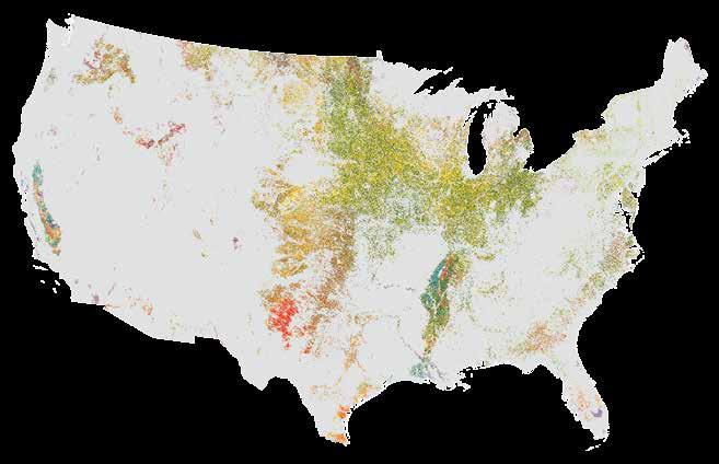
This document is for review purposes only. Do Not Distribute. (c) Esri Press. us department of agriculture
|
|
|
- Caroline Blair
- 6 years ago
- Views:
Transcription

1 us department of agriculture

2 Putting our data on these maps within our existing systems is a really, really big deal for us. Just clicking on a map is a more intuitive way for us to understand and to explore our own data. todd schroeder Director of Business Systems Management of the US Department of Agriculture Animal and Plant Health Inspection Service


3 USDA OFFICE OF HOMELAND SECURITY AND EMERGENCY COORDINATION GIS Support Maps for National Level Exercise and National Radiation Exercise We often think of disasters and their effects on cities, but planners must also consider the effects on the nation s farms. For the National Level Exercise 2011, ArcGIS maps show affected beef cattle farms and poultry and egg production farms that tested state and federal response to a magnitude 7.7 earthquake. These maps prepared with GIS help various agencies plan and prepare for disasters. 7


4 AGRICULTURAL RESEARCH SERVICE, US NATIONAL ARBORETUM US National Arboretum Botanical Explorer PROJECT BENEFITS This application provides the National Arboretum staff with intuitive, one-stop access to data, greatly expediting research. A kiosk in the visitor center helps visitors navigate the grounds, saving hours of staff time answering questions. Scientists, horticulturists, researchers, and the public want interactive maps of the National Arboretum. The Arboretum Botanical Explorer links plant records and images in a user-friendly display. Web-based ArcGIS drives the mapping functions that provide access to plant data, major gardens and collections, and unique features such as sculptures and structures. Researchers use the site to access every plant and associated data, and visitors use it for services and self-guided tours. The flexibility of GIS permits a variety of uses to benefit all users of the National Arboretum. 8

5 Coconino National Forest Initial Attack Map Book PROJECT BENEFITS Fire management on the Coconino National Forest now has a comprehensive, detailed, and easy-tonavigate map set that enables cost-effective fire suppression and resourcemanagement efforts. The Forest Service has to know how to react quickly and plan efficiently when fires break out, so it created this set of maps. Available in print, on mobile devices, and the dispatch website, these easy-to-access maps help staff improve emergency response plans and reduce forest fire damage. 9

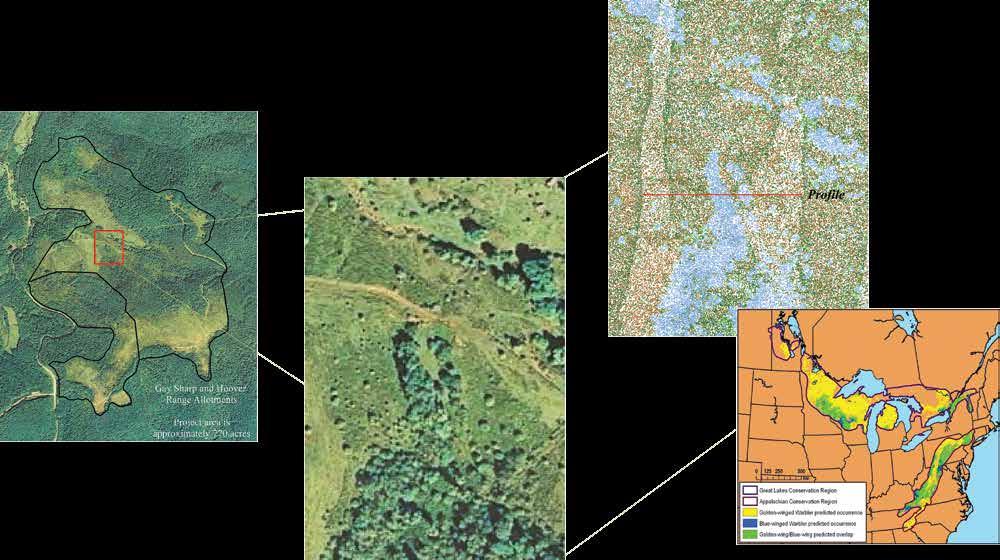
6 Golden-Winged Warbler Habitat Modeling The golden-winged warbler is a critically threatened bird species, and conservation efforts are under way to protect them. Developing a thorough understanding of their habitat structure may be the best way to construct a plan to manage a habitat for the remaining populations. Modeling their habitat using satellite imagery and GIS, as shown here, may be a crucial step toward saving them from becoming endangered. 10


7 11


.")
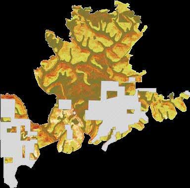
8 Best Management Opportunity Model Restoring Chestnut to the Landscape Chestnut tree blight has been a centurylong problem in the United States. The American Chestnut Foundation and the Forest Service have worked together to create a disease-resistant chestnut tree. The Forest Service s Allegheny National Forest in northwest Pennsylvania is working to restore resistant chestnut trees to the landscape. A GIS model was created to aid in the selection of chestnut restoration sites, and this map shows where the new trees can be successfully grown (lighter colored areas). As a result of this information, more of the disease-resistant trees are likely to survive. chestnut/history.php 12


9 u s d e pa r t m e n t o f ag r i c u lt u r e 13


10 Wallow Fire: Bringing Partners and Data Together The Forest Service needed a way to help agencies work together to manage fire recovery. To facilitate collaboration, the Forest Service used a GIS to build the Wildland Fire Geoportal, a website to share data and information about the 2011 Wallow Fire in northeast Arizona. This collection of online maps allows agencies to view, share, and analyze data from a single web and spatial interface. 14


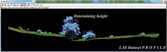
11 u s d e pa r t m e n t o f ag r i c u lt u r e Vegetation Height Santa Fe National Forest A large-scale, long-term project to restore sustainable ecological forest conditions is under way in the Southwest Jemez Mountains. The Forest Service used GIS and lidar to identify areas of dense stands of trees in need of thinning or prescribed fire to reduce fuel loads and help reduce the chance of catastrophic wildfire. The vegetation height data derived from lidar was also used to find areas with taller trees that were likely old growth stands. By identifying ecological components such as old growth and dense stands of trees, project planners are able to more successfully strategize forest restoration efforts. 15

12 Maah Daah Hey National Trail Map The Forest Service promotes sustainable community-based tourism on National Forest lands by providing activities such as bird watching, hiking, and cycling. To attract visitors, the Forest Service created an easyto-use and detailed trail map for the Little Missouri National Grasslands of North Dakota. GIS is used here to develop a product formatted and designed especially for hikers. Targeted guides like this help attract tourism and boost local economies by publicizing appealing activities to visitors of the area. 16

13 17


14 Forest Pest Conditions PROJECT BENEFITS GIS technology allows for the Forest Service to develop and deliver authoritative information gathered nationally in an efficient and cost-effective manner. The Forest Service needed a way to manage and distribute pest information that covers an enormous area and is used by many people. Using a GIS, the Forest Service developed pest damage databases and keeps them up to date. This website shows county-level maps of major forest insect and disease conditions throughout the United States. The ability to compile and publish timely information plays a significant role in managing national resources. 18


15 u s d e pa r t m e n t o f ag r i c u lt u r e Decision Support for Aerial Fire Retardant Avoidance PROJECT BENEFITS Using GIS to standardize data and processes streamlines the production of maps and improves access to resources for the fire community, both internal and external to the Forest Service. The Forest Service needs to provide comprehensive, up-to-date information for aerial fire response teams. To accomplish that goal, GIS was used to automatically generate nearly 11,000 regional maps that cover all national forests. This image shows one of those regional maps, the Foolhen Mountain area within the Beaverhead-Deerlodge National Forest in southwest Montana. 19


16 2010 Monitoring Trends in Burn Severity for Swakane, WA Fire management organizations need tools that help them determine the severity and scope of wildfire damage as quickly as possible. As shown here, GIS can be combined with post-fire satellite imagery to show how badly vegetation was burned and the amount of land affected. Such images contribute significantly to effective disaster management and response. 20


17 Fire Detections and Forest Service Lands: 2001 to 2011 To predict future fire management needs successfully, it is important to understand past patterns. The data depicted here shows ten years of fire history in the western United States based on satellite information that was collected daily and analyzed using GIS systems. The fire locations are combined with National Park Service administrative boundaries of inventoried and wilderness areas. By documenting, analyzing, and understanding fire occurrences and dynamics over long periods of time, the Forest Service can better serve its mission to protect national lands. 21

18 Rapid Assessment of Vegetation Condition after Wildfire PROJECT BENEFITS Investing in remote sensing and GIS technology improves the management of the National Forest System lands with more efficient and fiscally responsible decisions following a wildfire. To facilitate forest vegetation restoration after a wildfire, it is crucial to accurately identify post-fire vegetation severity. By identifying the areas where forest vegetation was affected after the 2012 Barry Point Fire in south central Oregon, this map uses GIS to identify areas of concern using a satellite image-based method of mapping vegetation conditions. This helps ensure cost-effective and timely reforestation and restoration efforts can be implemented within burned areas. 22


19 Lidar Applications in the USDA Forest Service In the past, scientists and technicians spent lots of time and money performing physically demanding and often dangerous field work to gather data about waterways, wildlife habitats, and forest inventory. These images showcase recent examples of how that time-consuming field work has been made more efficient by using GIS and airborne lidar data. 23

20 Potential Areas Suitable for Forest Restoration Projects PROJECT BENEFITS Automated and refined data processing tasks help decision makers evaluate where investments in restoration would yield the greatest benefit. The Geospatial Service and Training Center uses GIS to identify areas suitable for forest restoration in the western United States. This map has the potential to improve ecosystem health and contribute to local economies because more informed decisions about return on investment can be made. 24


21 The US Forest Service Interactive Visitor Map PROJECT BENEFITS It is important that visitors are provided with maps and applications that are accurate, accessible, and easy to navigate. The Forest Service recognizes that comprehensive web-based maps are the most efficient and cost-effective way to provide the public with information needed to experience national forests and grasslands in a safe manner. The Forest Service wants to make sure that visitors have the information they need to easily find the sites they would like to explore. To ensure a positive visitor experience, the Forest Service used GIS to create a simple, intuitive web interface for guest use. The Interactive Visitor Map allows guests to search for and locate their areas of interest. Once a sightseer finds a destination, he or she can view detailed information, create maps, and find the fastest route to get there. 25


22 NATIONAL AGRICULTURAL STATISTICS SERVICE USDA NASS Cropland Data Layer Accurate information on crop-specific land cover is necessary to estimate acreage for agricultural lands. GIS is used to automate the processing that accurately and objectively measures the percentage of crop cultivation in the United States, and the CropScape portal is how the data is accessed and distributed. The automated process made possible with GIS improves access to the information. 26

23 NATIONAL AGRICULTURAL STATISTICS SERVICE 27
October Effective Wildfire Mitigation in the Wildland-Urban Interface: A Research Summary
 October 2015 Effective Wildfire Mitigation in the Wildland-Urban Interface: A Research Summary 4 THE WILDFIRE THREAT 2013 Jaroso Fire via InciWeb (above) Wildfire threatens people and homes across the
Western Governors Association Policy Resolution Wildland Fire Management and Resilient Landscapes A. BACKGROUND
 Western Governors Association Policy Resolution 2016-06 Wildland Fire Management and Resilient Landscapes A. BACKGROUND 1. The health of the nation s federal forests and rangelands has deteriorated due
JUNE 20, Collaborative Initiatives: Restoring watersheds and large landscapes across boundaries through State and Federal partnerships
 TESTIMONY of LESLIE WELDON DEPUTY CHIEF, NATIONAL FOREST SYSTEM UNITED STATES DEPARTMENT OF AGRICULTURE FOREST SERVICE BEFORE THE SENATE COMMITTEE ON ENERGY AND NATURAL RESOURCES SUBCOMMITTEE ON PUBLIC
NDSU - North Dakota Forest Service North Dakota Cooperative Fire Protection Initiative Budget Request
 Agency Information NDSU - North Dakota Forest Service North Dakota Cooperative Fire Protection Initiative 2015-17 Budget Request North Dakota State Board of Higher Education May 29, 2014 NDSU-North Dakota
Fire & Fuels Management
 Overview Fire & Fuels Management Southern California Adaptation Implementation Plan During a two- day workshop in January 2016, southern California resource managers and regional stakeholders discussed
Appendix 5A Priority Landscapes GIS Analysis Methodology
 Appendix 5A Priority Landscapes GIS Analysis Methodology Overview This appendix describes the methodology used for Pennsylvania s Priority Landscapes GIS Analysis. The figure below is a conceptual diagram
Hyde Park Hyde Park Wildland Urban Interface Project. Scoping Information February 2017
 Introduction The Santa Fe National Forest is working as part of the Greater Santa Fe Fireshed Coalition (GSFF) to change conditions across a landscape critical to the vitality of our communities. The GSFF
USDA defers to the Department of the Interior regarding the impact of the legislation on the Department s programs and authorities.
 Statement of Leslie Weldon Deputy Chief, National Forest System Forest Service United States Department of Agriculture Before the United States Senate Committee on Energy and Natural Resources Subcommittee
PRESCRIBED FIRE IN SOUTHWEST IDAHO
 2016 PRESCRIBED FIRE IN SOUTHWEST IDAHO In southwest Idaho, public land managers work to: address public health and safety concerns; treat insect and disease infestations; reduce the risk of severe wildfires
Decision Memo for Pax Ponderosa Pine Planting Project
 Decision Memo for Pax Ponderosa Pine Planting Project USDA Forest Service Pacific Northwest Region Fremont-Winema National Forests Lakeview Ranger District Lake County, Oregon Introduction The Lakeview
FLORIDA S FOREST ACTION PLAN NATIONAL PRIORITIES. 1. Conserve and Manage Working Forest Landscapes for Multiple Values and Uses
 NATIONAL PRIORITIES SECTION Update Report STATE OF FLORIDA 2015 The 2008 Farm Bill, under Title VIII Forestry, amends the Cooperative Forestry Assistance Act of 1978, to include the requirement that each
WESTERN WILDLANDS ENVIRONMENTAL THREATS ASSESSMENT CENTER. Nancy Grulke, WWETAC John B. Kim, Pacific Northwest Research Station & WWETAC
 WESTERN WILDLANDS ENVIRONMENTAL THREATS ASSESSMENT CENTER Nancy Grulke, WWETAC John B. Kim, Pacific Northwest Research Station & WWETAC WWETAC DIRECTOR: FUNDING: Nancy Grulke US Forest Service DURATION:
RIM FIRE Preliminary Fuel Treatment Effectiveness Report
 RIM FIRE Preliminary Fuel Treatment Effectiveness Report USDA Forest Service, Pacific Southwest Region, Stanislaus National Forest DOI National Park Service, Pacific West Region, Yosemite National Park
Collaborative Forest Landscape Restoration Program
 Collaborative Forest Landscape Restoration Program Meg Roessing U.S.D.A. Forest Service Forest Management Staff Washington Office mroessing@fs.fed.us Background: Department and Agency Priority Our shared
Cross Boundary work is Key Collaborative restoration treatments across ownership boundaries are critical in creating fire adapted communities
 Millis Swamp Fire Croatan NF Cross Boundary work is Key Collaborative restoration treatments across ownership boundaries are critical in creating fire adapted communities Introduction While implementing
Sanborn Wildland Fire Risk Assessment System (WFRAS)
") Total Geospatial Solutions 1.866.SANBORN www.sanborn.com 1935 Jamboree Drive, Suite 100 Colorado Springs, CO 80920 January 23, 2009 Sanborn Wildland Fire Risk Assessment System (WFRAS) Using the Latest
Total Geospatial Solutions 1.866.SANBORN www.sanborn.com 1935 Jamboree Drive, Suite 100 Colorado Springs, CO 80920 January 23, 2009 Sanborn Wildland Fire Risk Assessment System (WFRAS) Using the Latest
Who are the Conservation Agencies & How do I contact them?
 Page 1 of 11 Who are the Conservation Agencies & How do I contact them? USDA Natural Resource Conservation (NRCS)...2 USDA Resource Conservation and Development (RC&D)...3 USDA Farm Agency (FSA)...4 USDA
Florida Emergency Hurricane State and Private Forestry Programs
 INTRODUCTION This request provides a summary of Hurricane Michael s impact on Florida s forest resources, an overview of damages and mitigation actions prescribed in response. SUMMARY Hurricane Michael
Ecological Restoration on the Klamath National Forest
 Ecological Restoration on the Klamath National Forest Dan Blessing Natural Resources Staff Officer Uncles Complex Klamath National Forest 08/17/2006 09:00 Objectives Policy overview What does it look like?
Florida Emergency Hurricane State and Private Forestry Programs
 INTRODUCTION This request provides a summary of Hurricane Michael s impact on Florida s forest resources, an overview of damages and mitigation actions prescribed in response. SUMMARY Hurricane Michael
Section 3: Land Management and Conservation
 Section 3: Land Management and Conservation Preview Classroom Catalyst Objectives Land Management Farmlands Rangelands Problems on the Range Maintaining the Range Forest Lands Section 3: Land Management
NEW Vision 2020 CFLRP Work Plan Template 2012
 Responses to the prompts on this work plan should be typed directly into this template 1. Describe the manner in which the proposal will be implemented to achieve ecological and community economic benefit,
STRATEGIC PLAN Introduction II. Mission Statement III. The Challenge Federal Noxious Weed Act of 1974
 VENTURA COUNTY WEED MANAGEMENT AREA (VCWMA) STRATEGIC PLAN 2010 I. Introduction The Ventura County Weed Management Area (VCWMA) is a focused group of individuals, Federal, State and County public agencies,
GPS Use in Wildland Fire Management. Dick Mangan, Program Leader
 Fire Tech Tips United States Department of Agriculture Forest Service Technology & Development Program May 1994 5100 9451-2337 MTDC GPS Use in Wildland Fire Management Dick Mangan, Program Leader By its
US Forest Service Open Space Conservation Strategy
 US Forest Service Open Space Conservation Strategy Transportation Research Board September 3, 2008 Atlanta, Georgia Photo Credit: Regents at the University of Minnesota. All rights reserved. Used with
Bastrop County, Texas Wildfire Mitigation Study
 SREF-CFS-002 Bastrop County, Texas Wildfire Mitigation Study The National Cohesive Wildland Fire Management Strategy is a national collaborative effort to bring a broad cross-section of stakeholders together
Blue Mountains ELK NUTRITION AND HABITAT MODELS
 USFS Pacific Northwest Blue Mountains ELK NUTRITION AND HABITAT MODELS Second generation models for management Managing for elk requires compromises among economic, ecological, and recreational objectives.
The Galton Project Kootenai National Forest. The Galton Project
 Introduction The Galton Project The Fortine Ranger District of the Kootenai National Forest is in the early stages of developing a project entitled Galton, named for the mountain range dominating the eastern
TO THE SUBCOMMITTEE ON FORESTS AND FOREST HEALTH, COMMITTEE ON RESOURCES, U.S. HOUSE OF REPRESENTATIVES
 TESTIMONY TO THE SUBCOMMITTEE ON FORESTS AND FOREST HEALTH, COMMITTEE ON RESOURCES, U.S. HOUSE OF REPRESENTATIVES Penelope Morgan, Professor, College of Natural Resources, University of Idaho, Moscow,
SUSTAINABLE FORESTRY INITIATIVE
 SAVAGE RIVER STATE FOREST ANNUAL WORK PLAN FISCAL YEAR 2018 FSC www.fsc.org FSC e C016194 The mark of responsible forestry SUSTAINABLE FORESTRY INITIATIVE Good for you. Good for our forests? SFI-00050
Restoration Forestry Restoration Forestry
 Restoration Forestry Why We Must Restore Forests Forests are among the most beautiful and renewable natural resources with which we have been entrusted. We have a moral obligation to make wise use of those
Innovative Approaches to Climate Resiliency and Restoration Across Ownerships and Landscapes Laura McCarthy
 Innovative Approaches to Climate Resiliency and Restoration Across Ownerships and Landscapes Laura McCarthy Restoring America s Forests The mission of The Nature Conservancy is to conserve the lands and
State and Private Forestry Fact Sheet. Investment in State's Cooperative Programs:
 State and Private Forestry Fact Sheet 2015 Idaho Investment in State's Cooperative Programs: Program FY 2014 Final Community Forestry and Open Space $0 Cooperative Lands - Forest Health Management $364,500
2009 ATFS National Required Sample Final Report
 February 21, 2010 2009 ATFS National Required Sample Final Report Introduction: The 2009 ATFS National Required Sample was used as part of the ATFS internal monitoring procedures to measure conformance
Focus Area Level Report Including Knowledge and Skills, and Performance Indicators
 Including Knowledge and Skills, and FOR 01.01 Describe the ecological concepts and principles; investigate and explain the relationships between these principles and forest development. FOR 01.01.01 Identify
PLANT AND ANIMAL DIVERSITY
 by the planning rule team as of. These ideas are for discussion purposes and do not What we want to achieve PLANT AND ANIMAL DIVERSITY The Forest Service is committed to protecting species and sustaining
The following recommendations will need to be re-evaluated given the recent fire at the Kennedy Meadows Pack Station.
 Kennedy Meadows Planning Unit The following recommendations will need to be re-evaluated given the recent fire at the Kennedy Meadows Pack Station. Sustainable Forestry Evaluate existing timber inventory
Wildlife Conservation Society Climate Adaptation Fund 2014 Restoring Oak Resilience at the Table Rocks, Rogue River Basin, Oregon FACT SHEET
 Wildlife Conservation Society Climate Adaptation Fund 2014 Restoring Oak Resilience at the Table Rocks, Rogue River Basin, Oregon FACT SHEET Project Overview Oak ecosystems in the Pacific Northwest exist
TITLE: Post-mountain pine beetle lodgepole pine forests: Assessing fire behavior and fire effects in the recently burned Pole Creek Fire area on the
 TITLE: Post-mountain pine beetle lodgepole pine forests: Assessing fire behavior and fire effects in the recently burned Pole Creek Fire area on the Sisters Ranger District, Deschutes National Forest.
Fire Susceptibility in Oregon
 Bomber 1 Fire Susceptibility in Oregon A Fire Risk comparison of Crater Lake National Park and the Umpqua National Forest Created in connection with Geography 368: Oregon Field Seminar Produced By Michael
J. ROADLESS 1. INTRODUCTION 2. REGULATORY FRAMEWORK 3. AREA OF ANALYSIS
 J. ROADLESS 1. INTRODUCTION The northeast portion of Unit 28 of the Mass Geis project falls within the 8,800 acre North Fork Smith Inventoried Roadless Area (IRA). Proposed treatments within the IRA include
Wildlife Conservation Strategy
 Wildlife Conservation Strategy Boise National Forest What is the Wildlife Conservation Strategy? The Boise National Forest is developing a Wildlife Conservation Strategy (WCS) in accordance with its Land
Whitebark Pine Restoration: You have to crack some eggs to make an omelette
 Whitebark Pine Restoration: You have to crack some eggs to make an omelette o Whitebark Pine in Region 1 o Endangered Species Act Status USA o USFS Sensitive Species Status o NEPA Framework for Restoration
Forests in the Farm Bill Coalition. Photo: David Harvey, Dixfield, Maine. Forest Priorities for the 2012 Farm Bill
 Forests in the Farm Bill Coalition Photo: David Harvey, Dixfield, Maine Forest Priorities for the 2012 Farm Bill January 2011 Congress and the Administration must work to ensure that the Farm Bill provides
Walla Walla Ranger District
 United States Department of Agriculture Forest Service Walla Walla Ranger District 1415 West Rose Walla Walla, WA 99362 509-522-6290 File Code: 1950 Date: September 30, 2014 Dear Forest User: The Walla
PARTNER CAUCUS on FIRE SUPPRESSION FUNDING SOLUTIONS
 Dear Members of Congress: For years the USDA Forest Service (USFS) and the Department of the Interior (DOI) have robbed from Peter to pay Paul, by transferring money out of vital agency programs and services
New Mexico. State & Private Forestry Fact Sheet. Investment in State's Cooperative Programs: Key Issues:
 New Mexico Investment in State's Cooperative Programs: Program State & Private Forestry Fact Sheet FY 2006 Final FY 2007 Estimate Cooperative Lands - Forest Health Management 528,850 306,000 Cooperative
File Code: 1900 Date: June 14, Dear Interested Parties,
 Logo Department Name Agency Organization Organization Address Information United States Forest National Forests in North Carolina 632 Manor Road Department of Service Appalachian Ranger District Mars Hill,
Kāhuna Ho oulu Ai - Botany and Agriculture
 Kāhuna Ho oulu Ai was practiced by all people who raised their food or accessed the forest for supplies, food and ceremonial needs. Kāhuna understood the seasons, connections of plants with their counterparts
Management of Florida s State-Owned Lands October 23, 2012
 Management of Florida s State-Owned Lands October 23, 2012 10/22/2012 1 Land Acquisition Update 2 2 Division of State Lands Role Acquire land on behalf of the Board of Trustees Identify appropriate land
Poker Chip Project. Noxious Weed Risk Assessment Almanor Ranger District Lassen National Forest
 Noxious Weed Risk Assessment Almanor Ranger District Lassen National Forest June 3, 2013 Introduction When a ground-disturbing action or activity is proposed, a Noxious Weed Risk Assessment (NWRA) determines
FOREST MANAGEMENT CAREERS
 FOREST MANAGEMENT CAREERS Forester Make woodland examinations and write plans tailored to a landowner s management objectives. Mark timber, conduct prescribed burning, supervise harvesting and planting
Sitgreaves Communities Wildfire Protection Plan
 Sitgreaves Communities Wildfire Protection Plan Update 2009 Prepared for: Navajo County, Coconino County, City of Show Low, Town of Pinetop-Lakeside Sitgreaves Communities Wildfire Protection Plan Update
Forest Stewardship Management Plan
 Forest Stewardship Management Plan James Starr, Forest Management 06/2003 Forest Stewardship Management Plans Plans must identify and describe actions to protect, manage, maintain and enhance relevant
Mission. Selected Accomplishments from Walnut Gulch. Facilities. To develop knowledge and technology to conserve water and soil in semi-arid lands
 USDA-ARS Southwest Watershed Research Center Mission Sound Science for Watershed Decisions To develop knowledge and technology to conserve water and soil in semi-arid lands ARS Watershed Locations Selected
American Tree Farm System Management Plan Template
 American Tree Farm System Management Plan Template State Tree Farm # Tree Farm Property Location Tree Farm Name: Ownership 1 : County: Tax Map ID: Location 2 : State: GPS Coordinates: Tree Farmer Contact
Parks, Trails, & Open Space
 Parks, Trails, & Open Space KEY PERFORMANCE MEASURES Acres of Parks, Trails, and Open Space Community Forest Coverage Forest Health Index Desired Outcome: Aspen s unique blend of natural resources provides
Fire History in the Colorado Rockies
 Fire History in the Colorado Rockies Brief overview of fire regimes in different forest ecosystem types Relationship of wildfire activity to climate variability Effects of fire exclusion and fire suppression
Aggressive Prescribed Fire Program Reduces Wildfire Severity: An Eglin Air Force Base Case Study
 SREF-CFS-060 Aggressive Prescribed Fire Program Reduces Wildfire Severity: An Eglin Air Force Base Case Study The National Cohesive Wildland Fire Management Strategy is a national collaborative effort
Whitebark Pine Restoration:
 Whitebark Pine Restoration: You have to crack some eggs to make an omelette Endangered Species Act Status - USA USFS Sensitive Species Status Framework for Restoration and Management Steve Shelly and R1
THE HONORABLE RON WALTER COMMISSIONER, CHAIR CHELAN COUNTY, WASHINGTON THE NATIONAL ASSOCIATION OF COUNTIES
 STATEMENT OF THE HONORABLE RON WALTER COMMISSIONER, CHAIR CHELAN COUNTY, WASHINGTON ON BEHALF OF THE NATIONAL ASSOCIATION OF COUNTIES BEFORE THE SUBCOMMITTEE ON FEDERAL LANDS UNITED STATES HOUSE OF REPRESENTATIVES
3.15 SNAG AND SNAG ASSOCIATED SPECIES
 3.15 SNAG AND SNAG ASSOCIATED SPECIES 3.15.1 Scope of the Analysis Snags play an important role in creating biodiversity on the landscape. They provide holes that are homes for birds and small mammals,
private lands partnerships
 A guide to private lands partnerships to conserve Florida wildlife Mark A. Trainor, Rogue Eye Photography David Moynahan Landowner Assistance Program Partnerships with private landowners to conserve Florida
Limber Pine and Whitebark Pine Recovery in Alberta
 Limber and Whitebark Pine Recovery in Alberta Partners in recovery Provincial recovery plans for whitebark pine and limber pine cover a large area that crosses jurisdictions. Collaboration and partnerships
CRS Report for Congress
 CRS Report for Congress Received through the CRS Web Order Code RS22024 January 14, 2005 Wildfire Protection in the 108 th Congress Summary Ross W. Gorte Specialist in Natural Resources Policy Resources,
Invasive Species There is an App and a Map for That
 Invasive Species There is an App and a Map for That Who am I? Information Technology Director Public Service Assistant in Entomology B.S. and M.S. in Computer Science President - National Exotic Pest Plant
Western Governors Association Policy Resolution Western Agriculture A. BACKGROUND
 Western Governors Association Policy Resolution 2017-09 Western Agriculture A. BACKGROUND 1. Agriculture and forestry in the western states and territories are significantly different than in other regions
Sitgreaves Communities Wildfire Protection Plan
 Sitgreaves Communities Wildfire Protection Plan Update Prepared for: Navajo County, Coconino County, City of Show Low, Town of Pinetop-Lakeside Sitgreaves Communities Wildfire Protection Plan Update Sitgreaves
Bear River Planning Unit. Fish, Plant, and Wildlife Habitat BEAR RIVER PLANNING UNIT
 BEAR RIVER PLANNING UNIT Yuba-Bear River Watershed Bear River Planning Unit Above all, the Stewardship Council recommends close coordination with the upcoming relicensing effort to ensure consistency with
Trends in Silviculture in B.C. ( )
") Forests Trends in Silviculture in B.C. (1970-2012) Silviculture is the practice of growing and cultivating trees in forests to meet certain objectives, such as timber production, biodiversity, wildlife
Forests Trends in Silviculture in B.C. (1970-2012) Silviculture is the practice of growing and cultivating trees in forests to meet certain objectives, such as timber production, biodiversity, wildlife
Agricultural Weather Assessments World Agricultural Outlook Board. World Agricultural Outlook Board Washington D.C., U.S.A.
 Agricultural Weather Assessments World Agricultural Outlook Board Harlan Shannon Agricultural Meteorologist U.S. Department of Agriculture World Agricultural Outlook Board Washington D.C., U.S.A. Historically,
Re: Initial Comments on the Mount Laguna and Pine Valley Community Defense and Healthy Forest Restoration Project
 Marian Kadota Adaptive Management Services Enterprise Team U.S. Forest Service 1072 Casitas Pass Road #288 Carpinteria, CA 93013 mkadota@fs.fed.us Re: Initial Comments on the Mount Laguna and Pine Valley
Presented by: Captain Frank Bigelow, CAL FIRE January 09, 2016
 Presented by: Captain Frank Bigelow, CAL FIRE January 09, 2016 CAL FIRE Video 2015 Review & History Current Drought Update Beetle Infestation Findings Summary Telegraph Fire Mariposa 2008 34,091 Acres
Post fire management program after the December 2010 fire Mt. Carmel forest, Israel
 April 11, 2011 Post fire management program after the December 2010 fire Mt. Carmel forest, Israel Naama Tessler *1,, Natan Elbaz 2, Didi Kaplan 2, Yehoshua Shkedy 2,Ben Rosenberg 2, Eyal Cohen 2, Lea
Fire Effects: Restoration of Watersheds and Springs Society for Ecological Restoration Southwest Chapter Conference November 20, 2015, Tucson, Arizona
 Fire Effects: Restoration of Watersheds and Springs Society for Ecological Restoration Southwest Chapter Conference November 20, 2015, Tucson, Arizona Fire in the southwest affects ecosystems both at the
A Report on the City of Chesapeake s Existing and Possible Urban Tree Canopy
 A Report on the City of Chesapeake s Existing and Possible Urban Tree Canopy Project Background The analysis of Chesapeake s urban tree canopy (UTC) was carried out at the request of the Virginia Department
Bushfire-Prone Area Assessment Report
 Bushfire-Prone Area Assessment Report Brompton Lodge, Cranbourne 7 May 2013 Bushfire Prone-Area Assessment Report Brompton Lodge, Cranbourne Date of Inspection: 10 th April, 2013 Prepared For: Clients
Executive Summary. San Marcos Pass - Eastern Goleta Valley Mountainous Communities Community Wildfire Protection Plan
 Executive Summary San Marcos Pass - Eastern Goleta Valley Mountainous Communities Community Wildfire Protection Plan The San Marcos Pass and Eastern Goleta Valley (SMP/EGV) Mountainous Communities Community
Ochoco, Umatilla, Wallowa-Whitman National Forests; Oregon and Washington; Blue Mountains
 [3410-11- P] DEPARTMENT OF AGRICULTURE Forest Service Ochoco, Umatilla, Wallowa-Whitman National Forests; Oregon and Washington; Blue Mountains Forest Resiliency Project AGENCY: Forest Service, USDA. ACTION:
Forest Stewardship Program
 Forest Stewardship Program James Starr, Forest Management 06/2003 Purpose of Forest Stewardship Program is to assist private forest landowners in more actively managing their forest and related resources;
Wildlands Recovery Plan for the Flathead National Forest
 Wildlands Recovery Plan for the Flathead National Forest Swan View Coalition and Friends of the Wild Swan March 2014 Wildlands Recovery Plan Overview Wildlands recovery on the Flathead National Forest
United States Department of Agriculture. Forest Service. Beaverhead-Deerlodge National Forest. September 2014
 United States Department of Agriculture Forest Service Beaverhead-Deerlodge National Forest September 2014 Beaverhead-Deerlodge National Forest Land and Resource Management Plan Explanation Supporting
Forested Watershed Health GIS Assessment. By Ryan Bollinger Presented by Valerie Cassity
 Forested Watershed Health GIS Assessment By Ryan Bollinger Presented by Valerie Cassity Introduction Primary Focus Area Summer Intern Results Meadow Monitoring Pacific Fisher Monitoring Forest Health Monitoring
A Report on the City of Lexington s Existing and Possible Urban Tree Canopy
 A Report on the City of Lexington s Existing and Possible Urban Tree Canopy Project Background Key Terms The analysis of Lexington s urban tree canopy (UTC) was carried out at the request of the Virginia
Appendix J. Forest Plan Amendments. Salvage Recovery Project
 Forest Plan Amendments Salvage Recovery Project APPENDIX J Lynx and Old Growth Forest Plan Amendments CHANGES BETWEEN DRAFT EIS AND FINAL EIS Changes in Appendix J between the Draft and Final EIS include:
State and Private Forestry Fact Sheet
 State and Private Forestry Fact Sheet Oregon 2018 Investment in State's Cooperative Programs Program FY 2017 Final Community Forestry and Open Space $0 Cooperative Lands - Forest Health Management $797,131
April 27, Dear Chairwoman Murkowski and Ranking Member Udall:
 April 27, 2018 The Honorable Lisa Murkowski Chair, Appropriations Subcommittee on Interior, Environment and Related Agencies U.S. Senate Washington, D.C. 20510 The Honorable Tom Udall Ranking Member, Appropriations
ADMINISTRATIVE RESOURCE MANAGEMENT, MAINTENANCE, SPECIAL EVENTS, RESOURCE MANAGEMENT, ENVIRONMENTAL EDUCATION, VOLUNTEER COORDINATION
 COUNTY BUREAU LEARNING EXPERIENCE MAJORS ALLEGHENY BUREAU OF TOPOGRAPHIC AND GEOLOGIC SURVEY THIS INTERN POSITION WILL ASSIST WITH SEVERAL FUNCTIONS RELATIVE TO BTGS PROJECT RESPONSIBILITIES UNDER PHASE
Introduction. Methodology for Analysis
 Scenic Report Prepared by: /s/gary Kedish Natural Resources Specialist for: Warner Mountain Ranger District Modoc National Forest January 20, 2016 Introduction This report focuses on the Visual Quality
Environment and Natural Resources Trust Fund 2014 Request for Proposals (RFP)
") Environment and Natural Resources Trust Fund 2014 Request for Proposals (RFP) Project Title: Forest Wildlife and Climate Change Research and Outreach ENRTF ID: 168-F Category: F. Methods to Protect, Restore,
Environment and Natural Resources Trust Fund 2014 Request for Proposals (RFP) Project Title: Forest Wildlife and Climate Change Research and Outreach ENRTF ID: 168-F Category: F. Methods to Protect, Restore,
The Secretaries have taken several administrative actions to accomplish these objectives, which include the following:
 STATEMENT OF MARK REY UNDER SECRETARY, NATURAL RESOURCES AND ENVIRONMENT UNITED STATES DEPARTMENT OF AGRICULTURE REBECCA WATSON ASSISTANT SECRETARY, LAND AND MINERALS MANAGEMENT DEPARTMENT OF THE INTERIOR
Upper Applegate Road Hazardous Fuel Reduction Project
 United States Department of Agriculture Forest Service March 2008 Environmental Assessment Upper Applegate Road Hazardous Fuel Reduction Project Siskiyou Mountains Ranger District Rogue River-Siskiyou
Frequently Asked Questions about the Cohesive Strategy and the. Northeast Regional Action Plan
 Frequently Asked Questions about the Cohesive Strategy and the Northeast Regional Action Plan What is the Cohesive Strategy? The National Cohesive Wildland Fire Management Strategy (Cohesive Strategy)
Pros and Cons of Salvage and Restoration Operations
 Pros and Cons of Salvage and Restoration Operations February 10, 2010 John Sessions College of Forestry Oregon State University Oregon Society of American Foresters Position Statement (2008) The OSAF supports
The Importance of Forest Management
 The Importance of Forest Management Molly Pitts Rocky Mountain States Director Sacramento Mountains Wood Industry Summit 3/30/16 Background Owner of Pitts Resource Consulting, LLC Rocky Mountain States
Medicine Bow Landscape Vegetation Analysis (LaVA) Cooperating Agency Meeting March 6, :30 a.m. 12:30 p.m.
 Cooperating Agency Meeting March 6, :30 a.m. 12:30 p.m.") Medicine Bow Landscape Vegetation Analysis (LaVA) Cooperating Agency Meeting March 6, 2017 9:30 a.m. 12:30 p.m. Condition-based NEPA A Cutting-edge Analysis Approach What it s Not What it Is How it Works
Medicine Bow Landscape Vegetation Analysis (LaVA) Cooperating Agency Meeting March 6, 2017 9:30 a.m. 12:30 p.m. Condition-based NEPA A Cutting-edge Analysis Approach What it s Not What it Is How it Works
Recommendations for Enhancing the Role of Forests In Climate Change Mitigation and Ecosystem Adaption to Climate Change
 NASF-2015-03 September 15, 2015 www.stateforesters.org Recommendations for Enhancing the Role of Forests In Climate Change Mitigation and Ecosystem Adaption to Climate Change A Policy Statement approved
Waste to Wisdom: Using crop and forest residues to create bioenergy and biochar
 Waste to Wisdom: Using crop and forest residues to create bioenergy and biochar Deborah Page-Dumroese USDA Forest Service, Rocky Mountain Research Station Moscow, ID ddumroese@fs.fed.us Overview A few
State and Private Forestry Programs
 Appropriation State and Private Forestry The Fiscal Year (FY) 2009 President s Budget proposes $109,500,000 for programs under the State and Private Forestry appropriation, a decrease in budget authority
2017 National Fire Plan Prescribed Fire Grant Summary
 2017 National Fire Plan Prescribed Fire Grant Summary Table of Contents 2017 National Fire Plan Prescribed Fire Grant Summary Report... 3-6 Treatment Photographs... 7 2 2017 National Fire Plan Prescribed