Ecosystem Profile THE PHILIPPINES HOTSPOT
|
|
|
- Lee Stevens
- 6 years ago
- Views:
Transcription
1 Ecosystem Profile THE PHILIPPINES HOTSPOT final version December 11, 2001
2 CONTENTS INTRODUCTION 3 The Ecosystem Profile 3 The Corridor Approach to Conservation 3 BACKGROUND 4 BIOLOGICAL IMPORTANCE OF THE PHILIPPINES HOTSPOT 5 Prioritization of Corridors Within the Hotspot 6 SYNOPSIS OF THREATS 11 Extractive Industries 11 Increased Population Density and Urban Sprawl 11 Conflicting Policies 12 Threats in Sierra Madre Corridor 12 Threats in Palawan Corridor 15 Threats in Eastern Mindanao Corridor 16 SYNOPSIS OF CURRENT INVESTMENTS 18 Multilateral Donors 18 Bilateral Donors 21 Major Nongovernmental Organizations 24 Government and Other Local Research Institutions 26 CEPF NICHE FOR INVESTMENT IN THE REGION 27 CEPF INVESTMENT STRATEGY AND PROGRAM FOCUS 28 Improve linkage between conservation investments to multiply and scale up benefits on a corridor scale in Sierra Madre, Eastern Mindanao and Palawan 29 Build civil society s awareness of the myriad benefits of conserving corridors of biodiversity 30 Build capacity of civil society to advocate for better corridor and protected area management and against development harmful to conservation 30 Establish an emergency response mechanism to help save Critically Endangered species 31 SUSTAINABILITY 31 CONCLUSION 31 LIST OF ACRONYMS 32 2
3 INTRODUCTION The Critical Ecosystem Partnership Fund (CEPF) is designed to better safeguard the world's threatened biodiversity hotspots in developing countries. It is a joint initiative of Conservation International (CI), the Global Environment Facility (GEF), the Government of Japan, the MacArthur Foundation and the World Bank. CEPF provides financing to projects in biodiversity hotspots, areas with more than 60 percent of the Earth s terrestrial species diversity in just 1.4 percent of its land surface. A fundamental purpose of the Fund is to ensure that civil society is engaged in efforts to conserve biodiversity in the hotspots. An additional purpose is to ensure that those efforts complement existing strategies and frameworks established by local, regional and national governments. CEPF will promote working alliances among community groups, NGOs, government, academic institutions and the private sector, combining unique capacities and eliminating duplication of efforts for a more comprehensive approach to conservation. CEPF is unique among funding mechanisms in that it focuses on biological areas rather than political boundaries, conceiving each area as a corridor and thus aiming to maximize biological survival through the establishment of a portfolio of projects which all contribute to an integrated landscape-scale program of conservation. It will also focus on transboundary cooperation when areas rich in biological value straddle national borders or in areas where a regional approach will be more effective than a national approach. CEPF aims to provide civil society with an agile and flexible funding mechanism complementing funding currently available to government agencies. In summary, CEPF offers an opportunity to promote the conservation of some of the most important ecosystems in the world places of high biodiversity and great beauty. CEPF will promote the engagement of a wide range of public and private institutions to address conservation needs through coordinated regional efforts. The Ecosystem Profile The purpose of the ecosystem profile is to provide an overview of the causes of biodiversity loss in a particular region and to couple this assessment with an inventory of current conservation activities in order to identify the niche where CEPF investment can provide the greatest incremental value. The ecosystem profile is intended to recommend broad strategic funding directions that can be implemented by civil society to contribute to the conservation of biodiversity in the targeted region. Applicants propose specific projects consistent with these broad directions and criteria. The ecosystem profile does not define the specific activities that prospective implementers may propose in the region, but outlines the conservation strategy that will guide those activities. For this reason, it is not possible or appropriate for the ecosystem profile to be more specific about the site or scope of particular projects or to identify appropriate benchmarks for those activities. Applicants will be required to prepare detailed proposals that specify performance indicators. The Corridor Approach to Conservation The corridor approach to biodiversity conservation seeks to provide a practical and effective solution to the universal difficulty of maintaining extensive areas of pristine habitat. It is recognized that large habitat parcels are essential for maintaining biodiversity and large-scale ecological processes, and that every opportunity to protect large bodies of habitat in perpetuity 3
4 should be taken. Nevertheless, few such opportunities exist. Existing protected areas are often too small and isolated to maintain viable ecosystems and evolutionary processes; indeed, in many hotspots, even the remaining unprotected habitat fragments are acutely threatened. In such circumstances, conservation efforts must focus on linking major sites across wide geographic areas in order to sustain these large-scale processes and ensure the maintenance of a high level of biodiversity. Such networks of protected areas and landscape management systems are biodiversity corridors. The main function of the corridors is to connect biodiversity areas through a patchwork of sustainable land uses, increasing mobility and genetic exchange among individuals of fauna and flora even in the absence of large extensions of continuous natural habitat. Such corridors not only promote the immediate goals of regional-scale conservation based on individual protected areas, but also help maintain the ecosystem processes needed in order to sustain biodiversity into the future. In this context, small habitat fragments within corridors perform several related functions connecting or reconnecting larger areas, maintaining heterogeneity in the habitat matrix, and providing refuge for species that require the unique environments present in these fragments. Large-scale intervention through biodiversity corridors, ecoregional planning, and landscape conservation is therefore one of the highest conservation priorities at the regional level in many of the world s hotspots and wilderness areas. From an institutional perspective, CEPF s adoption of the corridor approach aims to stimulate new levels of civil society participation in practical and political processes as a way to support government and corporate responses to conservation. The corridor approach relies on strategic partnerships with key stakeholders to build a support framework and to coordinate activities in the field. The active involvement of local stakeholders and the development of their planning and implementation skills are essential to the sustainability of the biodiversity corridor. BACKGROUND Before CEPF initiative in the Philippines Hotspot, the National Biodiversity Conservation Priority-Setting Program convened a series of regional consultation workshops to identify, assess, and prioritize geographic areas that best represent biodiversity of the different centers of endemism in the country and to formulate the strategy and actions needed to conserve Philippine biodiversity. The Protected Areas and Wildlife Bureau of the Department of Environment and Natural Resources (PAWB-DENR), together with Conservation International Philippines and the Biodiversity Conservation Program of the University of the Philippines Center for Integrative and Development Studies, spearheaded this process. Workshops were held in Luzon, the Visayas, and Mindanao, following 11 months of data collection, compilation, processing, and mapping. The resulting information served as basis for identification of priority conservation sites. The workshops involved site verifications and validation of the maps generated by the working groups, further data collection, identification of criteria for prioritization, and nomination of regional representatives for the national workshop. At least 40 local stakeholders participated in each workshop. The program culminated in the National Biodiversity Conservation Priority-Setting Workshop with participation by more than 200 local and international scientists and more than 70 institutions representing the government, NGO, academic, and donor communities, the private sector, and People s Organizations. 4
5 The workshops identified 19 terrestrial and nine marine regions (corridors) as top priority areas for biodiversity conservation in the country. Initiated by CEPF, additional stakeholder consultation workshops produced the results reflected in this ecosystem profile. The first workshop (August 7, 2001) identified three priority regions for CEPF funding. The workshop also identified the threats to biodiversity in each of these areas, and the root causes of those threats. More than 85 participants representing national government agencies, provincial governments, national and local NGOs, and academic institutions attended this workshop. The prioritization process used the following criteria: species richness, uniqueness, and distinctiveness habitat diversity species and habitat status utility and value in terms of tourism, economic activity, indigenous peoples, and research manageability in terms of size, political situation, local government capacity, number of NGOs present, and level of community awareness conservation efforts extent and quality of efforts already in progress Within the priority biogeographic regions, the participants in the stakeholder workshop recommended that CEPF focus on: Sierra Madre Biodiversity Corridor Eastern Mindanao Corridor Palawan Corridor These landscapes feature the largest tracts of remaining forest in the country and a diverse range of habitat types. Not surprisingly, these three regions hold the country s greatest species richness and diversity, accounting more than 70% of its plant species. Moreover, these corridors present some of the most promising opportunities for reconnecting forest and habitat fragments isolated by land use conversion, forest extraction, and other anthropogenic activities. While the selected regions cover a major portion of the Philippines biodiversity, the stakeholder review decisions will not protect all species with the highest probability of extinction. Therefore, it was recommended that emergency measures be put in place to ensure that some CEPF funding be available for species conservation throughout the Philippines Hotspot, with particular emphasis on West Visayas (particularly Negros, Panay and Cebu), Lake Lanao in central Mindanao, and the remaining lowland forest of Mindoro and the Sulus. BIOLOGICAL IMPORTANCE OF THE PHILIPPINES HOTSPOT The Philippines, a country of more than 7,000 islands with a combined landmass of 300,780 square kilometers, is the second-smallest of the 17 megadiversity countries in the world. It is also one of the most threatened hotspots, due to its population density the highest in Southeast Asia except for Singapore. The islands, most of which are now inhabited by humans, feature diverse topographic landscapes ranging from rugged volcanic mountains, plateaus, and vast fertile plains now cropland for rice, corn, and coconut to long coastlines with some of the 5
6 world s most colorful coral reefs. The varied geological histories of the different parts of the archipelago, with diverse climates and topography, contribute to the exceptionally diverse biota in the country. Each biogeographically distinct set of islands is home to a unique community of species of plants and animals, with larger islands holding more unique species than most countries, and even small islands supporting greater biodiversity than the biologically richest countries in Europe. The diversity of small biogeographic regions in such a compact area makes the Philippines ecologically unique. The Philippines is probably the most biologically diverse country in the world, in terms of unique terrestrial and marine plant and animal species per unit area. Moreover, the country has more endemic species than some larger megadiversity centers. Plant endemism is reported to be between 45-60%. The 2000 IUCN Red List of Threatened Species includes 193 species considered Threatened (Critically Endangered, Endangered and Vulnerable) in the Philippines.Invertebrate diversity is also high in the Philippines, with butterflies alone accounting for 895 species, 39% of which are endemic the second-highest number of endemics in the world after Indonesia. There are five major centers of endemism in the country and at least five minor ones, each supporting its own unique set of mammals, amphibians, plants, birds, reptiles, and butterflies, and each geographically isolated from the others. Prioritization of Corridors Within the Hotspot Sierra Madre Corridor The Sierra Madre Corridor is mostly terrestrial, but includes some of the Batanes-Babuyan islands straddling the South China Sea and the Northern Pacific zones. The terrestrial side is within the Greater Luzon Biogeographic Region and is largely defined by the Sierra Madre mountain range, the backbone of Luzon and the longest mountain range in the country. The corridor has a land area of about 1.8 million hectares in 10 provinces (Batanes, Cagayan, Isabela, Nueva Vizcaya, Quirino, Nueva Ecija, Aurora, Bulacan, Rizal, and Quezon) in Administrative Regions 2, 3 and 4. Sierra Madre contains the greatest number of protected areas 68 national parks, watershed forest reserves, natural monuments, marine reserves, protected landscapes and seascapes in all. Of these, the Northern Sierra Madre Natural Park is the largest and most important because it was the precursor to the biodiversity corridor concept and has served as a model for other regions in the Philippines. The corridor is not only rich in species diversity and endemism, but is home to many indigenous peoples, including the Agtas/Dumagats, Isneg, Ibanags, Ikalahans, Gaddangs, Ifugao, Ilonggots, and the Bugkalots or Negritos. The forest cover in the Sierra Madre Corridor is the most extensive in the Philippines about 1.4 million hectares, accounting for 25% of the country s forest resources, including more than 40% of the remaining old growth forests. Of the 13 forest types in the Philippines recognized by Whitmore (1984a), 11 were reported present in the corridor, including tropical evergreen rainforest, upper and lower montane rainforests, limestone forest, forest on ultramafic substrate, beach forest, and wetlands such as mangrove forest and freshwater swamp. 6


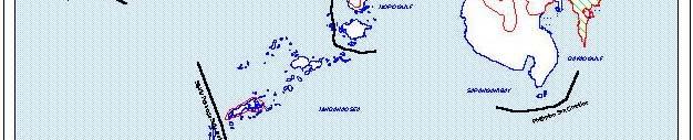
7 Terrestrial and Marine Biodiversity Corridors Identified by the National Biodiversity Conservation Priority-Setting Workshop 7


8 The biological importance of the corridor is not only due to the remaining intact forest in the central part of the mountain range, but also to the high plant biodiversity, with more than 3,500 species recorded in the area. This represents about 45% of species recorded in the country. The highest number of endemic plant species is found in this corridor, with 58% endemism within the corridor and 41% relative to the national figure. Generic endemism is also high, with 68% of endemic genera found in the corridor. The number of threatened plant species in the IUCN Red List is 106 for the corridor or 42% of the total threatened species of Philippine flora. The Sierra Madre corridor has the highest species diversity of birds in Luzon, accounting for at least 80% of all resident breeding birds of Luzon. Fourteen (20%) of the country s 65 threatened bird species have been recorded in Luzon. Diversity of other taxa is only partially documented, but species diversity generally is high, including 38 mammals, 40 reptiles and 17 amphibians. Five mammals and six reptiles are threatened with extinction. A total of 25 threatened higher vertebrates are present in the corridor, 75% of them endemic to the Philippines. Sierra Madre Corridor The corridor has 12 endemic amphibians (71%). Of the endemic bird species recorded in Luzon, 83% are present in the corridor 84 species. At least 55% of the mammal species in the corridor are endemic (21 species, or 24% of all endemic mammals found in Luzon). At least 16 reptile species (40%) are endemic. Palawan Corridor Palawan is geologically part of the Sunda Shelf (which includes Borneo, Sumatra, the Malay Peninsula, and Java), and is a biogeographic region of its own. Palawan is the fifth-largest island in the Philippine archipelago with an area of more than 11,000 square kilometers. It has a long mountainous backbone with three peaks above 1,500 meters. Several land formations in Palawan are of botanical importance: the Balabac islands; the ultrabasic formations in the mountain peaks of Mt. Mantalinghangan, Victoria/Anapahan, and 8
; karst formation of the rugged limestone terrain in the northern and northwest portion of the mainland (including El Nido); and the Calamianes group.")
, El Nido Marine Reserve (89,140 hectares), Malampaya Sound (90,000 hectares), and St.")
9 Mt. Bloomfield; primary forest of Mt. Puyos (Cleopatra s Needle); karst formation of the rugged limestone terrain in the northern and northwest portion of the mainland (including El Nido); and the Calamianes group. The biological importance of Palawan is recognized both nationally and internationally. In 1990, UNESCO declared the entire area as a Biosphere Reserve. The region includes several existing Proclaimed Conservation Areas namely, Coron Islands (7,580 hectares), El Nido Marine Reserve (89,140 hectares), Malampaya Sound (90,000 hectares), and St. Paul s Subterranean River National Park. The entire province has also been declared a mangrove reserve. Palawan encompasses various types of forest formations ranging from mangrove and beach forests to forests on ultramafic and limestone rocks, tropical lowland evergreen, moist deciduous, and upper montane rain forests. The northern part of the island is home to the endemic plant genus Adonidia (Palmae). It has been estimated that the island contains about 1,522 species of flowering plants with 15-20% endemism. Palawan Corridor Palawan supports 11 amphibians (46%) endemic to the Philippines eight of which are found only in Palawan. The island is also home to 25 Philippine endemic birds (15%), including 16 (62%) that occur only in Palawan, 18 endemic mammals (33%), including 15 (83%) that are endemic to Palawan, and 24 endemic reptiles (36%). In terms of conservation status, 23 faunal species are threatened: nine birds, six mammals, five reptiles, and one amphibian. At least 14 of the threatened species (61%) are endemic. Eastern Mindanao Corridor Eastern Mindanao forms part of the Greater Mindanao Biogeographic Region. Its northern boundary is Siargao Island, and it extends south to where Mt. Hamiguitan rises. To the west, portions of the Agusan Marsh delineate the area. Agusan Marsh has been declared a Wildlife Sanctuary and one of the 10 priority protected areas in the Integrated Protected Areas System; meanwhile, Siargao Island, Bucas Grande, 9

10 and other smaller adjacent islands and islets were declared as a unit having a Protected Landscape and Seascape status. Thirty-four sites have been prioritized by the National Conservation Priority-setting Workshop process for conservation within this region. Of these, 15 are classified as extremely high priority critical, 5 extremely high priority urgent, and 11 extremely high priority. One of the largest remaining blocks of dipterocarp forest in the country is found along the eastern portion of Mindanao. In fact, 75% of the country s extracted timber comes from this area. Plant diversity in the corridor comprises more than 2,300 plant species, accounting for some 31% of the Philippines total. Of these, 60% are endemic to the corridor and account for 29% of Philippines endemics. Eight endemic genera, 26% of the country s total, are found in this region. Thirty-one floral species in the corridor are threatened. Eastern Mindanao Corridor Bird diversity comprises about 178 species (67%) of resident breeding birds and mammal species (37) represent 42% of the native mammals in the Mindanao Biogeographic Region. Diversity of other taxonomic groups is only partially documented, but species diversity is high, including 26 amphibians and 62 reptiles. Eastern Mindanao has 16 amphibian species endemic to the Philippines (42%), several of which are confined to Mindanao. The corridor is home to 85 bird species, 81% of all Philippine endemics recorded in the Mindanao Biogeographic Region. It has 25 endemic mammal species (57%), including two species found only on Dinagat Island. Finally, Eastern Mindanao has 36 endemic reptiles (53%), several of which are confined to Mindanao. In terms of conservation status, at least 22 species are threatened, including the Philippine Eagle, Philippine Cockatoo, the Golden-crowned flying fox, and the Philippine crocodile. Siargao Island is home to the second-largest mangrove forest in Mindanao (86 square kilometers) and the largest contiguous stand of mangroves in the country (40 square kilometers). 10
11 SYNOPSIS OF THREATS The primary threat to biological diversity is habitat alteration and loss, especially rapid since 1980, caused by destructive resource use, development-related activities, and human population pressure.these factors are exacerbated by resource extraction (mining and logging) and land conversion for infrastructure, industrial, agricultural, and urban development. Root causes of these threats include: lack of understanding and appreciation for the value of biodiversity; weak resource management and governance mechanisms; insignificant financial commitment to formal mechanisms; lack of political will for conservation of biodiversity; insufficient enforcement of environmental laws; inappropriate and conflicting conservation policies; significant lack of ecological expertise in decision-making institutions and processes. lack of conservation knowledge and expertise among key stakeholders; and lack of sustainable livelihood for local stakeholders. Deeper analyses have shown that these causes are rooted in conflicting government policies and weak institutional mechanisms, reflecting a very low budgetary priority for nature and naturalresource conservation. Moreover, inequitable access to resources, poor governance, lack of public awareness and participation, lack of economic incentives, and poor use and allocation of resources all cause or exacerbate threats to biodiversity. Extractive Industries Destructive resource use emanates from extractive industries such as mining, logging and fishing, on commercial and small scales, and from the road building necessary to accommodate them. Philippine forests are subject to unsustainable mining and logging activities. Mining and logging are factors especially in Sierra Madre and Eastern Mindanao. Although these activities are regulated by the government, implementation of regulatory safeguards is hampered by corrupt practices that tend to disregard sustainability. Areas abandoned by commercial logging and mining concessions attract many small (and illegal) loggers and miners whose activities are generally more destructive. Where there are commercial logging and mining activities, there is migration of people seeking related employment opening up areas for settlements and bringing workers and families to previously uninhabited areas. Hunting, poaching, and flora collection follow human migration into upland areas, aggravating the threat to wildlife. Moreover, logged-over areas are often converted to kaingin (slash-and-burn) farms, clearing them of remaining vegetation. In addition, industrial and domestic pollution inland degrade river systems and coastal waters affecting riparian life and habitats. This is the case particularly in northeastern Mindanao. Increased Population Density and Urban Sprawl Population pressure as a threat to biodiversity stems mainly from the encroachment into and exploitation of biologically important areas by impoverished people whose primary concern is simply survival. Such people often migrate in substantial numbers between areas and islands, having lost their lands through such factors as soil erosion and exhaustion, landslips and volcanic 11
12 eruptions. The destructive slash-and-burn migrant farming of uplands and logged-over areas, illegal logging, and hunting and collection of wildlife and flora are widespread. Further, the mainstreaming of indigenous communities has resulted in the gradual loss of indigenous knowledge and practices, which are conservation-friendly. The lack of economic options forces many people to resort to destructive activities even as they are aware that these are not sustainable. Since these activities are largely fragmented and located in remote places, they are difficult to control without community assistance and support in the area. Expansion of towns and provinces within the corridors, because of increasing population density, is a further threat to biodiversity. The need for more land to be developed for settlements, economic activities, and transportation infrastructure creates tremendous pressure to convert forestlands to such uses. Industrial sites, housing subdivisions, power plants, and infrastructure projects sometimes encroach on buffer zones of protected areas, critical watersheds, and remaining primary and secondary forests. Tourism in coastal areas leads to the destruction of mangrove forests and reef areas along with their associated wildlife. These are evident in many sites within the corridors. Without proper land use control and environmental mitigation, these activities will result in further habitat destruction and biodiversity loss. Conflicting Policies Unclear land use policies at the national level create confusion and conflicts. Overlapping mandates and jurisdictions occur with respect to the use and management of forest lands where logging, mining, plantation, special uses and settlement encroachment are concerned. Similar problems occur at the local level in response to indiscriminate land use conversion and development projects. Weak consideration, if any, is given to environment and biodiversity conservation by local governments in land use decisions. A Comprehensive Land Use Plan (CLUP) for each municipality and province is required by law and is a prerequisite to the formulation of local or provincial development plans. The CLUP exercise in many Local Government Units (LGUs), however, tends to be weak and focused on the urban zones. The lack of process and understanding of the natural and socioeconomic resources of these areas, along with the overlapping institutional jurisdictions, precludes the rational determination of land uses necessary for the establishment of appropriate regulations. In cases where proper land use and zoning controls are in place, the problem lies with the political will to enforce those controls, particularly where there are unresolved conflicting uses and contending institutions or influential parties involved. These threats and their underlying causes are clearly demonstrated in each of the three corridors, which consequently were validated and confirmed by the stakeholder participants during the two consultation workshops. However, it should be noted that the degree of each threats influence differs among the corridors. Threats in Sierra Madre Corridor The Sierra Madre Corridor is mineral-rich and contains the most extensive forest cover in the country. The major threats to biodiversity in the terrestrial corridor are directly related to the extraction of these resources by logging and mining. The presence of these industries exposed biologically sensitive areas to population pressure, with ensuing small-scale logging, hunting, and agricultural activities that exacerbate the degraded state of much of the forest ecosystem. At the same time, logging and mining concessions (including small-scale illegal activities) have 12
13 influenced the development of support industries in the lowlands to process timber and mineral products. These ancillary industries, in turn, reinforce the primary industries and serve to influence political support and tolerance for their abuses. Logging and Related Activities Records of the Department of Environment and Natural Resources (DENR) showed 52 logging concessions granted Timber License Agreements (TLAs) to operate in the Corridor, specifically in Region 2, from 1965 to Of these, 12 were cancelled, 34 expired or were terminated, and six are still in effect three of which operate with an approved Integrated Annual Operation Plan. The three remaining concessions allow extraction of 46,622 cubic meters of timber from 857 hectares every year. Their operations have cut down remaining old growth forests at an average rate of 21,536 hectares per year. In cancelled or terminated TLA areas, on the other hand, indiscriminate timber poaching occurs due to open access. In the corridor, the cancellation or termination of logging operations has resulted in conversion from forest to agriculture or settlement areas and an increase in timber poaching as an alternative source of income for timber workers who are left behind, or for lowland migrants, due to the open access established during commercial logging. A recent study reported a reduction in commercial logging to less than 6,000 hectares in the corridor. Forest destruction, however, always exceeded 100,000 hectares per year, with forest destruction occurring much faster in areas with cancelled TLAs than in areas where concessions still operate. Timber poaching or illegal logging has also resulted in the annual reduction of mossy forest areas by 1,010 hectares, and the reduction of pine groves by 253 hectares. It has further led to the expansion of other brushlands at a rate of 12,654 hectares per year in Cagayan Province. Such activities, which primarily involve carabao logging, have also caused soil erosion resulting in severe or heavy siltation of the Cagayan valley river basin. In Isabela, there is timber poaching in the western side of the Northern Sierra Madre Natural Park (NSMNP) and its buffer zones. There has also been a substantial increase in the illegal felling and collection of narra, a hardwood species often used in furniture, due to the flourishing furniture trade in Isabela. A similar situation occurs in the province of Bulacan, where there is rampant illegal gathering of forest products for furniture. In Aurora province, illegal logging activities are rampant in Casiguran and San Luis, as well as hunting and gathering of fuelwood and minor forest products. This has resulted in landslides and soil erosion in the Pingit Watershed in Baler and sedimentation of the Diteki River. Although an 28,000 hectare area of primary forest in Quezon Province could comfortably support eight pairs of Philippine eagles, the area has been declared alienable and disposable, allowing its owners to obtain a private timber permit. The area is slated for conversion to multi-use development featuring a combination of leisure and recreation areas, housing, and institutional areas. Mining and Quarrying There have been 390 operating nonmetallic mines and quarries in the Sierra Madre corridor since 1999, including basalt, bentonite, diatomaceous earth, feldspar, guano, limestone, marble, red clay, sand and gravel, silica, and white clay. Only one operational and medium-scale gold mine existed in the corridor, operating from under a mineral lease covering about 800 hectares. 13
14 As of May 2001, numerous applications for exploration and mining (gold, copper, silver, manganese, other base metals, and limestone, covering an area of 811,541 hectares) have been filed in the three regions, with some of the applications covering overlapping areas. From these applications, 17 Exploration Permit Applications, four applications for Mineral Production Sharing Agreements, and six Financial or Technical Assistance Agreements refer to the slopes of the Sierra Madre Mountains, and two cover areas within the NSMNP. Combined, these applications cover 496,314 hectares. It should be noted that the largest primary montane forest in the NSMNP extends from Mt. Dos Cuernos in San Pablo south through the mountains of Cabagan and Maconacon to Divilacan and Tumauini around Mt. Cresta. This portion of the Natural Park will be seriously threatened once these mining applications are approved and construction and operations begin. Roads and Industrial Development Road building is arguably the most serious threat to conservation of biodiversity in the Sierra Madre corridor. The Cagayan Valley Strategic Development Plan identified road development as one of the main priorities in achieving a robust and sustainable economy for Region 2, whose Gross Regional Domestic Product (GRDP) has the second-lowest among the 14 regions of the country since The relatively slow development of the region is attributed to several constraints, including the underdeveloped transportation infrastructure. The present road network is unreliable and, in some places, nonexistent, making production areas inaccessible and marketing difficult. East-west road development in Northern Luzon is considered a development priority, and most of the proposed roads will go through the Sierra Madre Mountains. There are already five lateral roads and four coastal roads planned that will traverse the mountain range. Along the coast of the Sierra Madre Corridor, a proposed road from Dingading, San Guillermo to Dinapigue will traverse a protected area. Another proposed national road would cut through 72 kilometers of old growth forest in Gattaran, Baggao and Cagayan, a habitat of many endemic species. In addition, a proposed national road construction of about 67 kilometers will be cross the old growth forest to Barangay Bolos Point in the coastal area of Gattaran. Finally, a proposed provincial road will connect the valley side to the coastal barangays of the NSMNP. The Regional Development Council (RDC) of Region 2 has already approved this road. In the province of Quirino, the 50-kilometer Maddela-Casiguran Road that will connect Aurora to Quirino, the Maddela-Nagtipunan-A Castaneda-North Ecija Road, and the Maddela-San Agustin-Jones Road will also traverse the Sierra Madre Mountains. In addition to these proposed roads, there are two major industrial developments planned in the corridor: the Cagayan Special Economic Zone, which covers portions of the forest areas in Gonzaga and Santa Ana, Cagayan, and the proposed Pacific Coast City in General Nakar and Umiray, Quezon, which will affect 28,000 hectares of primary forest within the corridor. Another major development project that will take place in the corridor is the controversial Trans- Casecnan Hydropower Plant in the province of Quirino. This project will displace a number of indigenous communities from their ancestral lands and encroach on the Casecnan Protected 14
15 Landscape, the second-largest protected area in the Sierra Madre corridor (which has a priority rating of extremely high critical from the results of the priority-setting activity). It is expected that the construction of these roads and the resulting access to the Sierra Madre mountain range, and related development, will place the entire forest and adjacent marine ecosystem of the corridor in great peril. The physical and biological functions of these ecosystems will be under great pressure from inadequately managed development. Population Pressure The prevalence of illegal logging and gathering activities and kaingin farming in all the provinces of the corridor is an indication that there is human encroachment in the upland areas where the remaining forest cover is found. Threats in Palawan Corridor The major threats to biodiversity in Palawan are small-scale illegal logging; unregulated collection of timber and non-timber forest products; commercial and small-scale mining; conversion of mangroves into fishponds and rice fields; and illegal fishing and overfishing. The uncontrolled population migration in the corridor puts pressure on the limited land resources and has led to encroachment into sensitive areas where resources are exploited in unsustainable and destructive ways. Illegal Logging Palawan is the only island province in the country with more than 50% of its forest cover intact because, in 1993, commercial logging was banned in the province. This was the first legislative logging ban of its kind. However, small-scale illegal logging continues in parts of the province, especially in the northern and southern parts of Palawan. In fact, from , there were 364 arrests for illegal logging in the province, representing an estimated $1.1 million or more in poached timber for hardwood lumber and narra tiles. Illegal logging invariably attracts swidden farming or shifting cultivation in the upland areas. This is rampant throughout the province, resulting in deforestation, erosion, floods, and the extensive use of agrochemicals, particularly in the town of Taytay. Migration into Palawan has increased the number of forest occupants practicing shifting cultivation using lowland methods. Mining Most mining activities are small-scale, with only one large nickel mine operating in Rio Tuba in the southern part of the mainland. Chromite, copper, nickel, silica, marble, mercury, manganese, limestone, barite, feldspar, sand, gravel, washed pebbles, and guano are mined in small-scale operations. As of May 31, 2001, there are two applications for MPSAs, with a total area of 3,825 hectares. In the town of Camago, about 25 miles northwest of Malampaya, there is uncontrolled commercial mining activity going on. Development Programs ADB, JBIC, and the World Bank have ongoing projects intended to develop or improve roads, feeder ports, irrigation and airports in different parts of Palawan that may have direct or indirect adverse effects on the environment as well. There are also four pearl farming operations in the 15
16 province and other facilities processing marine products. Such activities can have a serious effect on the marine environment. Planned operations of Malampaya Gas are expected to bring significant revenue to the province from its share in the national wealth and local taxes. There are already some broad discussions of opportunities to use the revenue increase to further the development of Palawan. If such planning is not properly guided by environmental and conservation considerations, it might lead to land uses beyond the limited carrying capacity of Palawan s fragile environment. Population Pressure Palawan s population is growing at a rapid rate of 3.04% annually, mostly due to inbound migration. The high migration rate puts tremendous pressure on the upland forest areas and coastal areas where most of the migrants settle. Much of the destructive kaingin (slash and burn) cultivation and illegal fishing is associated with the relatively new migrant population coming to the province in search of livelihood. Threats in Eastern Mindanao Corridor Eastern Mindanao covers two major identified Area Development Zones: the Davao Gulf ADZ and the Caraga ADZ. The Davao Gulf ADZ, which includes Davao Oriental, is the most advanced area in Mindanao in terms of infrastructure, market links, and financial services; consequently, it is expected to remain the top exporter of key food crops and industrial products (wood, fabricated metal, rubber, and cement and other nonmetallic minerals) as well as a center of shipbuilding. The Caraga ADZ covering Surigao del Norte, Surigao del Sur, Agusan del Norte, and Agusan del Sur is slated for industrial and agricultural development, the growth of which is linked to the regional status of the Cagayan-Iligan and Davao Gulf regions as trade and industrial centers of Mindanao. These development plans provide the context for assessing human pressures on biodiversity and conservation initiatives in the corridor. Mining and Quarrying The most significant threat in Eastern Mindanao is the proliferation of mining operations. Gold, silver, nickel, copper, chromite, limestone, silica, and other precious metals, base metals, and nonmetallic minerals are mined throughout the corridor. At present, there are 10 large mines and quarries operating in Surigao and Agusan del Norte, Agusan del Sur and Compostela. In addition, there are 74 nonmetallic mines and quarries operating in the corridor, plus 16 applications for financial and technical assistance and 48 exploration permit applications. Apart from these, 27 MPSAs (covering 72,464 hectares) and 20 exploration permits (covering 90,259 hectares) had been issued by the MGB in the corridor as of June Some of these cover declared protected areas and watershed forest reserves within the corridor, where most ongoing conservation efforts will be concentrated. In Surigao del Norte, industrial waste and mine tailings are being dumped indiscriminately from open pits and tailing ponds of gold mining operations in Hinituan Passage. An open-pit chromite mine in Claver also caused heavy siltation of rivers. Because of indiscriminate dumping of mine 16
17 wastes, 1,639 damage claims were filed and processed by the DENR from The DENR has issued only a few minor citations against these operations; however, local grassroots action was able to suspend some mining in In Agusan del Norte, gold mining on commercial and small scales is prevalent in Cabadbaran, Santiago, Tubay, and Jabonga. Mine tailings are dumped in rivers such as the Kalinawan, draining into the Mindanao Sea and causing siltation of the coastal areas. Mining operations in San Roque Kitcharao are also polluting the headwaters of the Lambug River. Ongoing mineral extraction activities are mostly small-scale operations, including 15 mining permits as well as illegal miners in the gold rush area in East Morgado, Santiago. Logging and Timber Plantations One of the largest remaining blocks of dipterocarp forest in the country is found along this corridor. However, much of the remaining lowland dipterocarp forest is within logging concessions. In fact, 75% of the country s timber comes from this area. Large-scale logging and wood processing industries thus constitute a serious threat to biodiversity in the corridor. The two biggest logging concessions in the country are in Surigao province, within the EMC. One of these has a concession area of 360,670 hectares with a registered annual production capacity of 3 million cubic meters. There are only two other TLAs outside of the Surigao provinces: one in Agusan del Sur (72,680 hectares) and one in Agusan del Norte (98,312 hectares). The logging practices of these companies and TLA holders are often indiscriminate. One company is reportedly operating outside of its approved operation plan, which led to its suspension last year and exacerbated damage to the forest. Commercial logging is accompanied by the development of industrial tree and forest plantations, such as oil palm and bamboo plantations. As of 1998, there were 38 such plantations in the corridor, occupying more than 300,000 hectares. These plantations grow only one species of plant each e.g., falcata in Agusan del Norte and bamboo or palm trees in Agusan del Sur. To make matters worse, the DENR proposes to establish a timber corridor in this section of Mindanao that will cover at least 100,000 hectares. These operations threaten biodiversity, as they replace and alter natural ecological processes and create monocultures susceptible to pests and disease. Endemic plant species in the corridor are especially at risk. Illegal logging and kaingin activities in the uplands have also led to loss of forest cover and consequent soil erosion and sedimentation of rivers. Local authorities made arrests in for illegal extraction of hardwood lumber, round logs, and narra tiles in the corridor. Industrial Development and Land Conversion Development plans in the Caraga ADZ include economic centers that will catalyze domestic and foreign investment in the region. The 10 economic centers planned in Caraga would be the highest concentration of such facilities in the country. Two agro-industrial estates are already slated for development in the corridor: the Nasipit Industrial Estate and the Tubay Agro- Industrial Estate in Agusan del Norte. There are four large industrial establishments and two medium-scale manufacturing establishments being considered as a foundation for development of heavy industry and 17
18 manufacturing in the region. However, agriculture and forestry remain the biggest factors in the region s economy and job growth. The region has oil palm plantations and processing facilities, accounting for most of the country s production, with the largest plantations in Agusan del Sur (up to 8,000 hectares). Agriculture, especially in the Agusan River Basin, and marine fishing grounds in the west-central Pacific will be developed with the municipalities along the north coast of Mindanao. Moreover, the Nasipit and Surigao ports are expected to absorb the expansion of agricultural processing and light manufacturing from Cebu, Cagayan-Iligan, and Davao. Several industrial establishments in the region are engaged in marine and agricultural processing; most, however, deal with manufacturing of fabricated metal, nonmetallic mineral products, rubber products, industrial chemicals, transportation equipment, and paper products. Most (95%) of these operations are small-scale; heavy industries are limited to plywood and cement manufacturing and shipbuilding. In Siargao, there is extensive mangrove conversion by foreigners buying land to convert into beach resorts, and for firewood one of the main sources of livelihood on the island. Fuelwood is taken as far as Manila to supply bakeries. Artificial fishponds are installed near mangrove areas; reportedly, 576 hectares have been converted in Siargao and Bucas Grande (Management Plan of the Siargao Wildlife Sanctuary). Indiscriminate cutting of mangroves for firewood and clearing for fish ponds and prawn farms is also prevalent in Cabadbaran, Tubay, and Magallanes in Agusan del Norte. Land conversion from forest to farmland and residential and industrial settlements, or from agricultural to residential use, is also widespread throughout the corridor. Population Pressure Groups of people from Luzon (Ilocanos) and Cebu (Cebuanos) are migrating into Surigao del Sur, giving the area the fastest growth rate in the region. The indigenous population, including the Manobos, Higaonons, Mamanwas, Mandayas and Talaandigs of the corridor forests, are being integrated into the mainstream of lowland culture, losing much of their indigenous knowledge and ecologically sound practices. Some of these indigenous peoples are adopting destructive lowland farming techniques in the uplands. Additionally, they are involved in illegal logging. SYNOPSIS OF CURRENT INVESTMENTS There are efforts in progress in the Philippines to address the above threat directly or indirectly. This section outlines the major investments and participants in biodiversity conservation and describes their strategic priorities and accomplishments. Multilateral Donors The Global Environment Facility (World Bank as implementing agency): The World Bank is among the major active donors directly promoting protected area and natural resource management programs in the country for the purpose of biodiversity conservation and sustainable development. Through a $20 million grant fund from the GEF, the World Bank has supported the CPPAP from , the first project in the country that embodied the Integrated Protected Areas System (IPAS) concept. The legal framework used for this effort was the National Integrated Protected 18
19 Area System (NIPAS) Act of 1992, the first law on IPAS. This enabling legislation was designed to remedy the deficiencies of previous proclamations relating to national parks by ensuring that the existing protected areas be evaluated and reclassified, employing new classifications embodying management objectives and in accordance with internationally understood and recognized criteria, inclusion of indigenous and other local communities in management and recognition of the tenure of indigenous groups and long-established settlers. Because of this law, subsequent projects related to protected area management were implemented such as the EUfunded NIPAP project as well as the ADB buffer zone project in the country. CPPAP led implementation of the NIPAS focusing on the first 10 priority IPAS areas, two of which (Batanes Landscape and Seascape and NSMNP) are found in the Sierra Madre Corridor and another two (Agusan Marsh Wildlife Sanctuary and Siargao Islands Protected Seascape and Landscape) in the Eastern Mindanao. Investment to the NIPAP project supports: legitimization of the priority sites as protected areas through a process that eventually leads to a legislative proclamation; organizational development for the establishment of the Protected Area Management Board (PAMB), a multi-stakeholder body mandated to manage the IPAS areas; site and resource management activities including the development of management plans for IPAS areas and improved enforcement of environmental protection laws; recognition of tenure rights of indigenous communities and settled migrants; and socioeconomic development. A consortium of national NGOs, the NGOs for Integrated Protected Area (NIPA), is implementing the project with support from the DENR. This is the first and only major NGOmanaged project outside of the medium-sized and small grants programs of the GEF. Success has been achieved in legitimizing the protected area status of some sites, organizing effective PAMBs and undertaking management and enforcement activities against illegal mining and logging operations, particularly in the NSMNP and around Lakes Kamansihan and Mantuod in the EMC. Implementation, however, is rather slow and marred by squabbles and bureaucracy within the NIPA at the national level and the PAMB at the site level. Technical and procedural problems have hampered the utilization of the livelihood fund and have prevented significant progress in implementing the socioeconomic development component of the program that is critical for sustainability. Other donor support has been generated to complement the CPPAP. This includes Asian Development Bank technical assistance to establish buffer zones, and Technical Assistance for Improving Biodiversity Conservation in Protected Areas, funded by DANIDA and the World Bank, which has developed an innovative Biodiversity Monitoring System now being implemented in many protected areas. Other World Bank resource management projects addressing conservation include: The sectoral adjustment loan for the environment implemented by the DENR in Northern Luzon and Mindanao, covering the northern Sierra Madre Corridor (including all of Region 2) and the Eastern Mindanao (Agusan and Surigao del Norte). The program piloted forest watershed management initiatives involving strong community and LGU support, and 19
A Historic Role for Protected Areas
 I A Historic Role for Protected Areas From ocean depths to sun-washed mountain peaks, protected areas are refuges for life and for our natural heritage. They conserve ecological systems larger than countries,
Land Accounting for SDG Monitoring and Reporting
 Regional Expert Workshop on Land Accounting for SDG Monitoring and Reporting Bangkok - Thailand 25-27 September 2017 Mrs. Niroshinie De Silva Assistant Director Ministry of Mahaweli development & Environment
Ecosystem Profile for the Guinean Forests of West Africa Biodiversity Hotspot
 Ecosystem Profile for the Guinean Forests of West Africa Biodiversity Hotspot Lunchtime Conference External Cooperation Infopoint 19 January 2016 The Guinean Forests Hotspot 2 Past CEPF investment in the
SECTOR ASSESSMENT (SUMMARY): AGRICULTURE AND NATURAL RESOURCES 1
: AGRICULTURE AND NATURAL RESOURCES 1") Country Partnership Strategy: Philippines, 2011 2016 SECTOR ASSESSMENT (SUMMARY): AGRICULTURE AND NATURAL RESOURCES 1 A. Sector Performance, Problems, and Opportunities 1. Sector importance and growth
Country Partnership Strategy: Philippines, 2011 2016 SECTOR ASSESSMENT (SUMMARY): AGRICULTURE AND NATURAL RESOURCES 1 A. Sector Performance, Problems, and Opportunities 1. Sector importance and growth
Chapter 30. Conserving Earth s Biodiversity
 Chapter 30 Conserving Earth s Biodiversity Chapter 30 At a Glance What Is Conservation Biology? Why Is Biodiversity Important? Is Earth s Biodiversity Diminishing? What Are the Major Threats to Biodiversity?
Sustaining Terrestrial Biodiversity: Saving Ecosystems and Ecosystem Services
 LIVING IN THE ENVIRONMENT, 18e G. TYLER MILLER SCOTT E. SPOOLMAN 10 Sustaining Terrestrial Biodiversity: Saving Ecosystems and Ecosystem Services Core Case Study: Costa Rica A Global Conservation Leader
Humans in the biosphere 6.1 A changing landscape
 Humans in the biosphere 6.1 A changing landscape How do our daily activities affect the environment? Humans affect both regional and global environments Have major impacts on the quality of Earth s natural
SUMMARY. Biodiversity trends and threats
 Vietnam is one the most biologically diverse countries in the world and is recognized as a high priority for global conservation. Its natural ecosystems include a rich variety of productive and beautiful
GEF BENEFITS INDEX FOR BIODIVERSITY (GBI BIO ) Background and Context
 Background and Context") Background and Context GEF BENEFITS INDEX FOR BIODIVERSITY (GBI BIO ) 1. The GEF Benefits Index for Biodiversity (GBI BIO ) provides a relative ranking of countries for meeting the biodiversity objectives
Background and Context GEF BENEFITS INDEX FOR BIODIVERSITY (GBI BIO ) 1. The GEF Benefits Index for Biodiversity (GBI BIO ) provides a relative ranking of countries for meeting the biodiversity objectives
Southeast Asia s BIODIVERSITY Challenges
 Southeast Asia s BIODIVERSITY Challenges Roundtable for ASEAN Chief Justices and Senior Judiciary on Environmental Law Clarissa Arida Director Programme Development and Implementation ASEAN Centre for
Conservation International
 Conservation International Summary of the Statement Conservation International continues to support the implementation of the SDS-SEA mainly through its Sulu-Sulawesi Seascape (SSS) Project. CI will continue
13. CRITERIA AND INDICATORS FOR ASSESSING SUSTAINABILITY OF SMALLHOLDER TREE PLANTATIONS IN SELECTED REGIONS IN THE PHILIPPINES
 13. CRITERIA AND FOR ASSESSING SUSTAINABILITY OF SMALLHOLDER TREE PLANTATIONS IN SELECTED REGIONS IN THE PHILIPPINES Priscila C. Dolom, Teodoro R. Villanueva and Ma. Magdalena B. Villanueva A study was
Strategic Plan of Action
 Heart of Borneo Strategic Plan of Action Bridging Conservation and Sustainable Development in Three Countries Strategic Plan of Actions The Heart of Borneo Initiative Introduction The Heart of Borneo
Open Working Group, February 2014: Australia, the Netherlands, United Kingdom Constituency Statement. Oceans and Seas, Forests and Biodiversity
 Open Working Group, February 2014: Australia, the Netherlands, United Kingdom Constituency Statement Oceans and Seas, Forests and Biodiversity Healthy ecosystems, biological diversity (biodiversity) and
SECTOR ASSESSMENT (SUMMARY): AGRICULTURE, NATURAL RESOURCES, AND RURAL DEVELOPMENT 1
: AGRICULTURE, NATURAL RESOURCES, AND RURAL DEVELOPMENT 1") Country Partnership Strategy: People s Republic of China, 2016 2020 SECTOR ASSESSMENT (SUMMARY): AGRICULTURE, NATURAL RESOURCES, AND RURAL DEVELOPMENT 1 Sector Road Map A. Sector Performance, Problems,
Country Partnership Strategy: People s Republic of China, 2016 2020 SECTOR ASSESSMENT (SUMMARY): AGRICULTURE, NATURAL RESOURCES, AND RURAL DEVELOPMENT 1 Sector Road Map A. Sector Performance, Problems,
Overview of the Philippine Biodiversity Strategy and Action Plan (PBSAP) Updating Process
 Updating Process") Overview of the Philippine Biodiversity Strategy and Action Plan (PBSAP) Updating Process Presentation Outline Review of the 1 st and 2 nd Philippine Biodiversity Strategy and Action Plans (PBSAP) 3 rd
Overview of the Philippine Biodiversity Strategy and Action Plan (PBSAP) Updating Process Presentation Outline Review of the 1 st and 2 nd Philippine Biodiversity Strategy and Action Plans (PBSAP) 3 rd
CONSERVATION OF ENVIRONMENT ENACTMENT 1996 CONSERVATION OF ENVIRONMENT (PRESCRIBED ACTIVITIES) ORDER 1999
 ORDER 1999") (No. JPBN. 1509/27 Vol. II CONSERVATION OF ENVIRONMENT ENACTMENT 1996 CONSERVATION OF ENVIRONMENT (PRESCRIBED ACTIVITIES) ORDER 1999 In exercise of the powers conferred by section 5 of the Conservation
(No. JPBN. 1509/27 Vol. II CONSERVATION OF ENVIRONMENT ENACTMENT 1996 CONSERVATION OF ENVIRONMENT (PRESCRIBED ACTIVITIES) ORDER 1999 In exercise of the powers conferred by section 5 of the Conservation
3. Present Situation of Environmental Problems
 3. Present Situation of Environmental Problems 3.1 Natural Environment The goals, issues and programmes regarding the natural environment of the Ten Year Perspective Development Plan 2001-2011 are shown
10 Facts about Forest Protection
 Forests are a precious natural 1 resource Forests are dominated by trees but there are also animals, plants, soils and rocks. Forests and forestland in Laos belongs to the state, and is regulated by Lao
,- to oversee, support, and, whenever appropriate, conduct activities and programmes to study, and monitor the status of, biological diversity;
 National Biodiversity Strategy and Action Plan (NBSAP), St. Lucia - page 20 8. IMPLEMENTATION Institutional arrangements In accordance with the provisions of Article 4, 6 and 18(4) of the CBD, the design
Assessing Five Years of CEPF Investment In The Philippines Biodiversity Hotspot. A Special Report March 2007
 Assessing Five Years of CEPF Investment In The Philippines Biodiversity Hotspot A Special Report March 007 CONTENTS Overview... CEPF 5-Year Logical Framework Reporting... 9 Appendices... 8 OVERVIEW The
GOLDEN APPLE SNAIL DAMAGE AND MANAGEMENT PRACTICES IN RICE FAMERS FIELDS IN THE LAO PDR
 GOLDEN APPLE SNAIL DAMAGE AND MANAGEMENT PRACTICES IN RICE FAMERS FIELDS IN THE LAO PDR Bounneuang Douagbupha and Khamouane Khamphoukeo National Agricultural Research Center National Agricultural and Forestry
Why Countries are Constructing Ecosystem Accounts
 Why Countries are Constructing Ecosystem Accounts Glenn Marie Lange, Program Leader for WAVES Global Partnership, The World Bank Bogota, Colombia September 25, 2013 1. Simple approach to ecosystem accounting
State of Agriculture in the Uplands of Southern Mindanao
 State of Agriculture in the Uplands of Southern Mindanao (focused in UDP covered barangays) Aurea Christie Galvez-Lumaad, Environment Coordinator Resource Management Component Upland Development Programme
EXECUTIVE SUMMARY. Soil erosion caused by wind and / or water
 EXECUTIVE SUMMARY Introduction The objective of this report is to inform the Conference of the Parties on the situation of the country with regard to measures taken to implement the United Nations Convention
Presentation During the Philippine Press Institute s Seminar-Workshop on the Valuation of Natural Capital Almont Hotel, Butuan City March 21, 2017
 Presentation During the Philippine Press Institute s Seminar-Workshop on the Valuation of Natural Capital Almont Hotel, Butuan City March 21, 2017 Flawed Logic in Natural Resource Utilization and Management
POLICY BRIEF. BORDERING ON A WATER CRISIS: The Need for Integrated Resource Management in the Mara River Basin
 POLICY BRIEF BORDERING ON A WATER CRISIS: The Need for Integrated Resource Management in the Mara River Basin Bordering on a Water Crisis: The Need for Integrated Resource Management in the Mara River
Sustainable Biodiversity M anagement in
 Sustainable Biodiversity M anagement in ASEAN: Regional initiatives and the challenges of connecting to development Policy Dialogues on the Economics of Ecosystems and Biodiversity 9 February 2012 Bangkok,
LINKAGES BETWEEN WOMEN, LIVELIHOODS & ENVIRONMENTAL SECURITY
 Nigeria in Focus LINKAGES BETWEEN WOMEN, LIVELIHOODS & ENVIRONMENTAL SECURITY Panel Discussion by George Akor Program Manager, Women Environmental Programme (WEP), Nigeria Key Messages Progress in human
Ecological Gap Assessment: An Overview
 Ecological Gap Assessment: An Overview 1. What is a gap assessment? 2. Why is it important? 3. What are some general principles? 4. What are the major steps? 5. What can we learn from gap analysis? 1.
The International Model Forest Network 2008
 International Model Forest Network The International Model Forest Network 2008 Developing collaborative opportunities for advancing sustainability Fred Pollett, Associate International Model Forest Network
WORLD WILDLIFE FUND. Conservation Strategies Unit 1250 Twenty-Fourth St, NW Washington, DC 20037
 The Conservation Strategies Unit s mission is to anticipate the challenges and opportunities of large-scale conservation, and to identify and promote innovative and targeted responses. Through our commitment
Mainstreaming Climate Change Adaptation Into Development March 2013
 Mainstreaming Climate Change Adaptation Into Development 18-20 March 2013 Challenges to Climate Change Adaptation in Socially Vulnerable and Marginalized group Palawan, Philippine by: Merlinda V. Hilario
ECOLOGICAL ZONING AS A POLICY TOOL FOR SUSTAINABLE DEVELOPMENT AT THE LOCAL LEVEL
 ECOLOGICAL ZONING AS A POLICY TOOL FOR SUSTAINABLE DEVELOPMENT AT THE LOCAL LEVEL Candido A. Cabrido, Jr. School of Urban and Regional Planning, University of the Philippines, Diliman ECOLOGICAL ZONING
Conservation Area Network in the Southern Appalachians
 Hugh Irwin Susan Andrew Conservation Area Network in the Southern Appalachians Introduction The Southern Appalachian Forest Coalition (SAFC) is currently developing a proposal for a regionally integrated
Indonesia. Landscape Factsheet
 Indonesia Landscape Factsheet In Indonesia, through an integrated approach, we drive sustainable commodity production, livelihood improvement and forest conservation in several landscapes. In Aceh, our
Dang Thi Tuoi Biodiversity Conservation Agency (BCA) Ministry of Natural Resources and Environment of Vietnam (MONRE)
 Ministry of Natural Resources and Environment of Vietnam (MONRE)") Dang Thi Tuoi Biodiversity Conservation Agency (BCA) Ministry of Natural Resources and Environment of Vietnam (MONRE) Main Contents: 1. Roles of biodiversity in Vietnam 2. Threats to biodiversity in Vietnam
Dang Thi Tuoi Biodiversity Conservation Agency (BCA) Ministry of Natural Resources and Environment of Vietnam (MONRE) Main Contents: 1. Roles of biodiversity in Vietnam 2. Threats to biodiversity in Vietnam
SUSTAINABLE LAND IN THE PHILIPPINES
 SUSTAINABLE LAND MANAGEMENT IN THE PHILIPPINES RODELIO CARATING AND RODRIGO BADAYOS BUREAU OF SOILS AND WATER MANAGEMENT AND UNIVERSITY OF THE PHILIPPINES LOS BAÑOS OUTLINE OF PRESENTATION INTRODUCTION
Beverly. Produced in This report and associated map provide information about important sites for biodiversity conservation in your area.
 CONSERVING THE BIODIVERSITY OF MASSACHUSETTS IN A CHANGING WORLD Beverly Produced in 2012 This report and associated map provide information about important sites for biodiversity conservation in your
USDA FOREST SERVICE International Programs. Land Use Conversion
 USDA FOREST SERVICE International Programs Addressing the Four Threats in an International Context Land Use Conversion Introduction The loss of open space through conversion of forestlands to developed
Biodiversity: Who cares?
 Biodiversity: Who cares? Which do you like better? A B Which do you like better? A B Which do you like better? A B Which do you like better? A B Which do you like better? A B Which do you like better?
KANNELIYA-DEDIYAGALA-NAKIYADENIYA PROPOSED BIOSPHERE
 J. Natn. Sci. Foundation Sri Lanka 2003 31(1&2): 139-145 COMMUNITY PARTICIPATION IN THE MANAGEMENT OF THE KANNELIYA-DEDIYAGALA-NAKIYADENIYA PROPOSED BIOSPHERE RESERVE H. M. BANDARATILLAKE Director, Forest
OPERATIONAL GUIDLINES OF BOAD
 Coastal and Littoral Management 1. There is no precise definition of coastal areas. All definitions include coastal waters, marine waters and estuaries, and some portions of the land along the coast where
Science Plan. Executive Summary. Introduction
 Science Plan Executive Summary This Science Plan will establish and define the focus of the Peninsular Florida Landscape Conservation Cooperative (PFLCC) science investments. The data and products derived
Philippine experiences in the implementation of initiatives that address Climate Change and Land Degradation. and Land Degradation
 World Meteorological Organization Philippine experiences in the implementation of initiatives that address Climate Change and Land Degradation International Workshop on Climate Change and Land Degradation
St. Petersburg Declaration
 DRAFT 20 October 2005 Elements of St. Petersburg Declaration We, the representatives of the Governments from Europe and North Asia, countries from other continents and the European Commission, participating
Greening Growth Through HRD Interventions
 Greening Growth Through HRD Interventions Sub-Theme: Strategic Human Resource Development in an Era of "Green Growth ROLANDO L. METIN Career Executive Service Board, Philippines Green Growth as National
GOAL NATURE COUNT$ How does UNDP s work support this SDG? Case study: Protected areas management in Myanmar
 NATURE COUNT$ GOAL 15 Protect, restore & promote sustainable use of terrestrial ecosystems, sustainably manage forests, combat desertification, halt and reverse land degradation and halt biodiversity loss
Managing Natural Resources
 Managing Natural Resources The Sierra Leone Conference on Development and Transformation (Rethinking development after 50 years experience) Presented By Andrew K. Bomah (Theme Leader) Sierra Leone is endowed
Forests in Vietnam and the Partnership for Forestry Development. Production forests. Special-use forests. forests
 Forests in Vietnam and the Partnership for Forestry Development Ms Pham Minh Thoa Department of Forestry Ministry of Agriculture and Rural Development B9, 2 Ngoc Ha, Ba Dinh Hanoi, Vietnam Mthoa-dfd@netnam.vn
Developing Country Application of the Analytical Assessment Tools
 Developing Country Application of the Analytical Assessment Tools Ricardo M. Umali 1 The Philippine criteria and indicators and applications This paper provides a model for an analytical assessment tool
VEGETATIVE, WATER, FISH AND WILDLIFE RESOURCES POLICIES
 VEGETATIVE, WATER, FISH AND WILDLIFE RESOURCES POLICIES The County will: GOALS AND OBJECTIVES 1.1 Conserve, Enhance, Protect, Maintain and Manage Vegetative, Water, Fish and Wildlife Resources Promote
EAST AFRICAN COMMUNITY DEVELOPING EAC FORESTRY POLICY AND STRATEGY TERMS OF REFERENCE
 EAST AFRICAN COMMUNITY DEVELOPING EAC FORESTRY POLICY AND STRATEGY TERMS OF REFERENCE EAC SECRETARIAT ARUSHA FEBRUARY, 2018 1 1. INTRODUCTION The East African Community (EAC) is an inter-governmental organization
Understanding tropical deforestation
 Understanding tropical deforestation By NASA, adapted by Newsela staff on 03.13.17 Word Count 1,466 Level 1170L Two logging trucks on the Kalabakan-Sapulot-Road take heavy tropical timber logs to the log
Trinidad and Tobago-Protected Areas and Wildlife Management Project
 Project Name Region Sector Project ID Report No. PID2517 Trinidad and Tobago-Protected Areas and (@) Wildlife Management Project Latin America and the Caribbean Caribbean Country Management Unit Environmentally
International Symposium on Integrated Coastal Management for Marine Biodiversity in Asia, January 14-15, 2010, Kyoto, Japan
 Understanding the role of NGO in biodiversity conservation through WWF efforts on MPA development in Vietnam Tham Thi Ngoc Diep Marine Programme, WWF Greater Mekong - Vietnam Programme diep.thamngoc@wwfgreatermekong.org
Strengthening Local Capacity: Environmental and Disaster Risk Governance in the Philippines. Dr. Francisco A. Magno. De La Salle University-Manila
 Strengthening Local Capacity: Environmental and Disaster Risk Governance in the Philippines Dr. Francisco A. Magno De La Salle University-Manila Disaster Problem The Philippines is beset by a host of natural
MESSAGE OF THE V TH IUCN WORLD PARKS CONGRESS TO THE CONVENTION ON BIOLOGICAL DIVERSITY
 MESSAGE OF THE V TH IUCN WORLD PARKS CONGRESS TO THE CONVENTION ON BIOLOGICAL DIVERSITY The V th IUCN World Parks Congress met on 8-17 September in Durban, South Africa, bringing together some 3000 delegates,
Guinean Forests of West Africa Biodiversity Hotspot Program for Consolidation
 Guinean Forests of West Africa Biodiversity Hotspot Program for Consolidation June 2008 Background Critical Ecosystem Partnership Fund (CEPF) investment in the Upper Guinean Forest Ecosystem concluded
Bushmeat-the Sudan Experience
 Bushmeat-the Sudan Experience Prepared and presented by: Ahmed S. El Wakeel, Ph.D. Professor of Ecology ARC Sudan Ex-National Biodiversity Coordinator - Sudan for the: JOINT MEETING OF THE CBD LIAISON
Ch. 11 Biodiversity. Central Case: Saving the Siberian tiger
 Ch. 11 Biodiversity Central Case: Saving the Siberian tiger The largest cat in the world The Russian Far East mountains house the last remaining tigers Nearly became extinct due to hunting, poaching and
Forest Management for Timber Production in the Tropics: case studies from Costa Rica, Guatemala, Nicaragua
 Forest Management for Timber Production in the Tropics: case studies from Costa Rica, Guatemala, Nicaragua Kathleen McGinley USDA Forest Service International Institute of Tropical Forestry Outline Global
The Social and Economic Importance of Canada s Privately Owned Forest Lands
 The Social and Economic Importance of Canada s Privately Owned Forest Lands Key Points n Private forests make up 6% of Canada s 402 million ha of forested land and 13% of the managed forest. n Private
What is an ecosystem?
 What is an ecosystem? An ecosystem is generally defined as a community of organisms living in a particular environment and the physical elements in that environment with which they interact. (http://www.enviroliteracy.org/category.php/3.html)
Experience of Maldives in NBSAP Target Setting
 CBD -FAO workshop on restoration of forests and other ecosystems 27 june- 1 july Bangkok, Thailand Experience of Maldives in NBSAP 2016-2025 Target Setting Ministry of Environment and Energy Republic of
The Challenge of Climate Change in Guatemala s Coastal Zone
 The Challenge of Climate Change in Guatemala s Coastal Zone Lilian Yon B. The United Nations-Nippon Foundation Fellowship Programme 2011 2012 October 26, 2011 Guatemala is prone to natural disasters The
Chapter 18 Conservation of Biodiversity. Tuesday, April 17, 18
 Chapter 18 Conservation of Biodiversity Module 59 The Sixth Mass Extinction After reading this module you should be able to explain the global decline in the genetic diversity of wild species. discuss
Ms. Lynette T. Laroya. Department of Environment and Natural Resources
 Ms. Lynette T. Laroya Department of Environment and Natural Resources Outline I. Overview II. Biophysical and Socio- Economic Characteristics III. Issues and Threats IV. Governance V. MPAS and Networks
STRATEGIC PLAN
 TROPICAL FOREST CONSERVATION ACTION FOR SUMATERA STRATEGIC PLAN 2010-2015 A. BACKGROUND Sumatra is one of the global biodiversity hot spot, meaning that this area has become one of the conservation priority
CONVENTION ON INTERNATIONAL TRADE IN ENDANGERED SPECIES OF WILD FAUNA AND FLORA
 SC62 Inf. 4 (English only / únicamente en inglés / seulement en anglais) CONVENTION ON INTERNATIONAL TRADE IN ENDANGERED SPECIES OF WILD FAUNA AND FLORA Sixty-second meeting of the Standing Committee Geneva
CLIMATE CHANGE ADAPTATION PRACTICES IN AGRICULTURE, FISHERIES AND NATURAL RESOURCES AMONG THE INDIGENOUS PEOPLES IN REGION 02, NORTHERN PHILIPPINES
 CLIMATE CHANGE ADAPTATION PRACTICES IN AGRICULTURE, FISHERIES AND NATURAL RESOURCES AMONG THE INDIGENOUS PEOPLES IN REGION 02, NORTHERN PHILIPPINES MANUEL S. TAN JR.,Ph.D. Cagayan State University Tuguegarao
Effective REDD+ Safeguards: Lessons from Forest Certification An Asia-Pacific Perspective
 DECODING REDD Effective REDD+ Safeguards: Lessons from Forest Certification An Asia-Pacific Perspective Social and environmental safeguards are essential for the success of REDD+. This was a key message
UNDP-Spain MDG Achievement Fund. Terms of Reference for Thematic Window on Environment and Climate Change
 UNDP-Spain MDG Achievement Fund Terms of Reference for Thematic Window on Environment and Climate Change This document provides policy guidance to UN Country Teams applying for funding under the UNDP-Spain
Country profile of Sri Lanka and present status of NBSAPs
 Regional Capacity- Building workshop For Ecosystem Conservation and Restoration to Support Achievement of the Aichi Biodiversity Targets Country profile of Sri Lanka and present status of NBSAPs Hasula
Chapter 6 Oil-palm estate development in Southeast Asia: consequences for peat swamp forests and livelihoods in Indonesia
 81 Chapter 6 Oil-palm estate development in Southeast Asia: consequences for peat swamp forests and livelihoods in Indonesia In this chapter, the DPSIR analysis is applied to oil-palm development in the
Figure 1: map of East Asia showing land masses and water bodies. Source: PEMSEA
 Annex 1. Technical Background The Seas of East Asia1 The seas of East Asia are defined as the Yellow Sea, the East China Sea, the South China Sea, the Gulf of Thailand, the Sulu-Celebes (Sulawesi) Sea,
The State of the World s Land and Water Resources for Food and Agriculture. FAO Regional Office for Asia and the Pacific
 The State of the World s Land and Water Resources for Food and Agriculture FAO Regional Office for Asia and the Pacific Resources availability land and water availability in high income countries land
BIODIVERSITY AND ECOSYSTEM SERVICES PROGRAM. An Overview
 BIODIVERSITY AND ECOSYSTEM SERVICES PROGRAM An Overview AN UNPRECEDENTED OPPORTUNITY LAC holds 40% of the world s biological diversity The Latin America and Caribbean (LAC) Region is among the richest
Milne Bay Corridor Planning A systematic conservation planning approach to opportunity cost trade-offs
 Milne Bay Corridor Planning A systematic conservation planning approach to opportunity cost trade-offs Presented at Melanesia CBC Management Team Meeting, Jayapura, Indonesia 12 September 2005 Corridor
Helping to Better Manage the World s Oceans
 THE WORLD BANK Helping to Better Manage the World s Oceans The World Bank and the Drive for Blue Growth SYNOPSIS A healthy ocean is a valuable natural asset that, if maintained and nurtured, can provide
THE FIRST IRAQI NATIONAL REPORT TO THE CONVENTION ON BIOLOGICAL DIVERSITY
 THE FIRST IRAQI NATIONAL REPORT TO THE CONVENTION ON BIOLOGICAL DIVERSITY CHAPTER I BIODIVERSITY VALUES MARSH Most Most important fresh fresh and and brackish water water system of of the the region Breeding
OTBA. THEME: Forests - Friends for Life
 OTBA THEME: Forests - Friends for Life The forest is a complex ecosystem consisting mainly of trees that have formed a buffer for the earth to protect life forms. The trees which make up the main area
Background information on Biodiversity, Ecosystem Services and Human Well-being
 Background information on Biodiversity, Ecosystem Services and Human Well-being Glossary: Biodiversity: The variability among living organisms from all sources including, inter alia, terrestrial, marine
Chapter Four: Overview. Introduction to Environmental Geology, 5e. Case History: Endangered Trout. Ecology and Geology Linkage
 Chapter Four: Overview Introduction to Environmental Geology, 5e Chapter 4 Ecology and Geology Jennifer Barson Spokane Falls Community College Linkages between geology with ecology and relationships with
Puerto-Princesa Subterranean River National Park
 Puerto-Princesa Subterranean River National Park 2017 Conservation Outlook Assessment SITE INFORMATION Country: Philippines Inscribed in: 1999 Criteria: (vii) (x) Site description: This park features a
Name of project: Climate Adaptation for Biodiversity, Ecosystem Services and Livelihoods in Rural Madagascar
 Name of project: Climate Adaptation for Biodiversity, Ecosystem Services and Livelihoods in Rural Madagascar Overall objectives: Assist Madagascar to improve its understanding and assessment of the impacts
16 Biological Resources
 16 Biological Resources Overview of Chapter 16 Biological Diversity Extinction and Species Endangerment Endangered and Threatened Species Where and why species are endangered Conservation Biology Conservation
Water and Climate Change. David Coates Secretariat of the Convention on Biological Diversity Montreal Canada
 Water and Climate Change David Coates Secretariat of the Convention on Biological Diversity Montreal Canada Water and climate change How important is water? What do ecosystems have to do with it? How important
Susan P. Abano Engineer IV Policy and Program Division
 National Water Resources Board Integrated Water Resources Management Susan P. Abano Engineer IV Policy and Program Division National Water Resources Board Outline Philippines Water Resources Situationer
MARINE POLLUTION DEGRADATION MITIGATION MANAGEMENT IS ESSENTIAL FOR IMPROVING MARINE ENVIRONMENT
 MARINE POLLUTION DEGRADATION MITIGATION MANAGEMENT IS ESSENTIAL FOR IMPROVING MARINE ENVIRONMENT The health of the world s oceans and marine life is degrading rapidly as a result of excess human activities.
ISSUES PROPOSED INTERVENTIONS. Water Scarcity and Pollution. Inadequate Legislation. Overexploitation. Human Settlements and Migration
 Sindh Strategy 66 CHAPTER 6 Wetlands Wetlands are amongst the most productive ecosystems in the world with extensive and rich food webs and biodiversity. Due to their location on the flyway to Central
COALITION TO SAVE INDONESIA S SMALL ISLANDS
 COALITION TO SAVE INDONESIA S SMALL ISLANDS Briefing Paper The Crisis of Forest Ecosystems in Indonesia s Small Islands Important Task for Indonesian President Joko Widodo A. Introduction Indonesia is
INTERNATIONAL WATERS EXPERIENCE NOTES
 INTERNATIONAL WATERS EXPERIENCE NOTES http://www.iwlearn.net/experience 2015-01 Designing a Payment for Ecosystem Services (PES) Project in Taytay, Palawan: Establishing the Benchmark Lake Manguao. Photo
OVERVIEW OF THE MINING INDUSTRY
 OVERVIEW OF THE MINING INDUSTRY ENGR. LEO L. JASARENO Director Mines and Geosciences Bureau Department of Environment and Natural Resources Republic of the Philippines ROUNDTABLE DISCUSSION ON MITIGATING
Social Studies 10-1 Chapter 13: Impacts on the Environments To what extent does globalization affect the environment?
 Social Studies 10-1 Chapter 13: Impacts on the Environments To what extent does globalization affect the environment? RESOURCE DEVELOPMENT & LAND USE A society is defined not only by what it, but by what
Environmental Checklist: 26. Forestry Projects(1) Confirmation of Environmental and Social Considerations. Environmental Item.
 Confirmation of Environmental and Social Considerations. Environmental Item.") Checklist: 26. Forestry Projects(1) 1. Permits and Approvals, Explanations 2. Antipollution Measures (1) ESIA and Permits (2) Explanations to the Public (1) Air Quality (2) Water Quality (3) Waste (4)
Checklist: 26. Forestry Projects(1) 1. Permits and Approvals, Explanations 2. Antipollution Measures (1) ESIA and Permits (2) Explanations to the Public (1) Air Quality (2) Water Quality (3) Waste (4)
Resolution XI.3. Adjustments to the Strategic Plan for the triennium
 11 th Meeting of the Conference of the Parties to the Convention on Wetlands (Ramsar, Iran, 1971) Wetlands: home and destination Bucharest, Romania, 6-13 July 2012 Resolution XI.3 Adjustments to the Strategic
Integrated landscape approach
 Integrated landscape approach Terry Sunderland Ani Adiwinata Nawir Capacity-building workshop for South East Asia on ecosystem conservation and restoration to support achievement of the Aichi Biodiversity
15 Conservation of an Island Biodiversity Hotspot Th e g o v e r n m e n t o f Kapikua wants to expand biodiversity conservation efforts
 15 Conservation of an Island Biodiversity Hotspot Th e g o v e r n m e n t o f Kapikua wants to expand biodiversity conservation efforts on the island. The government has two goals: 1) to protect the overall
HUTAN HARAPAN. Ecosystem Restoration in Production Forest Areas
 HUTAN HARAPAN Ecosystem Restoration in Production Forest Areas THE ECONOMICS OF RESTORATION: EXPERIENCE FROM REKI-HUTAN HARAPAN BUSINESS IN INDONESIA Natural Forest Concession Ecosystem Restoration Concessiom