EKKER NATURE PRESERVE LAND MANAGEMENT AND LAND USE PLAN
|
|
|
- Gerard Poole
- 6 years ago
- Views:
Transcription


1 Prepared for ENVIRONMENTAL LANDS ACQUISITION AND PROTECTION PROGRAM HILLSBOROUGH COUNTY PARKS RECREATION AND CONSERVATION DEPARTMENT CONSERVATION SERVICES SECTION McMullen Road Riverview, Florida (813) PREPARED BY 3450 Buschwood Park Drive, Suite 345 Tampa, Florida FEBRUARY 2007
2 SECTION TABLE OF CONTENTS Page 1.0 GENERAL INFORMATION Location of Ekker Nature Preserve History and Objectives of Ekker Nature Preserve NATURAL RESOURCES Soils Soils Distribution Soils Description Soils Management Measures Natural and Man-made Communities Mapping Process Vegetation Community Descriptions Water Resources Aquatic Preserves and Outstanding Florida Waters Water Quality Water Resource Management Measures Fish and Wildlife Resources Existing Conditions Management Measures for Fish and Wildlife Special Status Species Descriptions of Special Status Species Management Measures for all Special Status Species CULTURAL RESOURCES Definition of Terminology Cultural Resources Survey Management Measures for Cultural Resources RECREATIONAL RESOURCES Existing Recreational Facilities Greenways and Trails RESOURCE MANAGEMENT Site Security Exotic Species Management Invasive Exotic Plants Invasive Exotic Animals Prescribed Burns The Importance of Fires Management Measures for Fire HABITAT RESTORATION... 21
3 TABLE OF CONTENTS (CONT.) 7.0 COMPLIANCE ELAPP Policies and Ordinances Compliance with Comprehensive Plans Preserve Expansion Opportunities SUMMARY OF MANAGEMENT GOALS AND OBJECTIVES REFERENCES LIST OF FIGURES FIGURE 1 LOCATION MAP... 2 FIGURE 2 SOILS... 4 FIGURE 3 NATURAL COMMUNITIES... 7 FIGURE 4 AQUATIC PRESERVES FIGURE 5 ALAFIA RIVER WATERSHED FIGURE 6 GREENWAYS AND TRAILS LIST OF TABLES TABLE 1 SOILS DISTRIBUTION... 3 TABLE 2 NATURAL COMMUNITIES... 6 TABLE 3 SPECIAL STATUS SPECIES TABLE 4 - PROPOSED MANAGEMENT GOALS APPENDICES APPENDIX A LEGAL DOCUMENTS APPENDIX B SPECIES LIST APPENDIX C RESOURCE MANAGEMENT POLICIES APPENDIX D CULTURAL RESOURCES SURVEY APPENDIX E GREENWAYS AND TRAILS MASTER PLAN ELEMENTS APPENDIX F - SAMPLE BURN PLAN APPENDIX G WETLAND CREATION AREA 90% CONSTRUCTION PLANS APPENDIX H - ENVIRONMENTALLY SENSITIVE LAND ORDINANCES APPENDIX I - HILLS. CO. COMPREHENSIVE PLAN RELEVANT ELEMENTS APPENDIX J - POTENTIAL EXPANSION OPPORTUNITIES APPENDIX K ANNUAL BUDGETS
4 EKKER NATURE PRESERVE 1.0 GENERAL INFORMATION 1.1 Location of the Ekker Nature Preserve The Ekker Nature Preserve is located in central Hillsborough County, in Section 25, Township 19 South, Range 19 East, between Spivey and Ekker Roads with Symmes Road forming the southern boundary. Bullfrog Creek forms the northern boundary for the entire length of the Preserve, approximately one and one half miles upstream from the creek s confluence with Tampa Bay in Gibsonton, Florida. The surrounding land uses are predominantly agricultural, fish farming, and medium density residential areas. The former fish farms to the south of the property have been developed into medium range single family housing. Figure 1 provides a location map of the Ekker Nature Preserve, as well as other public lands in the vicinity. Appendix A provides the legal description, warrantee deeds, boundary survey, easements, and other legal documents for the Preserve. 1.2 History and Objectives of the Preserve The Ekker Nature Preserve consists of two parcels purchased at different times. The larger parcel is approximately 70 acres and includes the eastern portion of the Preserve. This parcel was settled by Alfred and Marie Ekker who built a homestead on the site in After they died in 1997, the property was turned over to the Ekker Family Trust, which consisted of Jeanie Ekker Johnson and her brothers Sammy and Hugo Ekker. The land was purchased in 2001 for $572,000 by the Save Our Rivers program (SOR), a part of the Southwest Florida Water Management District (SWFWMD). The SOR was reimbursed by the Hillsborough County Environmental Lands Acquisition and Protection Program (ELAPP) for fifty percent of the purchase price and an agreement to manage the land through a lease agreement with SWFWMD. Jeanie Ekker Johnson and her husband Pete remain on the property as site security residents and caretakers. Since the purchase of this property the former homestead was remodeled, fencing was improved and some of the exotic vegetation was treated. Other improvements are pending. An adjacent acre parcel was purchased by SWFWMD in 2003 for $158,100 to compliment the Preserve. This parcel is located on the west side of the Ekker property and consisted of an old homestead and predominantly undeveloped lands, with Bullfrog Creek as its northern boundary. Improvements to this property since purchase include the removal of the old house and out buildings, and removal of interior fencing. 1
5 PASCO Gulf of Mexico HILLS BOROUGH POLK PINEL LAS Ekker Nature Preserve RIVERVIEW DR MA NA TE E Alafia River Park Alafia River GIBSONTO N DR Ekker Nature Preserve Hillsborough Bay The Kitchen Preserve Golden Aster Scrub Nature Preserve Fred & Idah Schultz Preserve Legend Preserve Boundary Other Public Land BIG BEND ROAD Aerial Source: SWFWMD 2004, 1 meter Prepared for: { parsons 0 2,000 4, Buschwood Park Drive, Suite 345 Tampa, Florida Feet J:\DATA\ ELAPP-2\Lower Bullfrog Creek Nature Preserve\GIS\LowerBullfrog_Location8x11.mxd Hillsborough County Florida FIGURE 1 Ekker Nature Preserve Location Map
6 2.0 NATURAL RESOURCES 2.1 Soil Resources Soils Distribution According to the United States Department of Agriculture/Natural Resource Conservation Service (formerly Soil Conservation Service) Soil Survey of Hillsborough County (USDA 1989), there are five different classifications of soils found in the Ekker Nature Preserve. Table 1 lists the soils and the surface area they cover within the Preserve. Figure 2 highlights the five soil types and shows their distribution throughout the Preserve. Some discrepancies may occur between the aerial photograph and the soil distribution; for instance the soil map indicates open water where there is obviously tree cover on the creek. This may be attributed to either a change in the channel of the creek over time that is not reflected in the GIS data or the fact that some of the tree canopy hangs over the creek. Table 1 Ekker Nature Preserve Soils Distribution Map Number Soil Type Acreage 3 Archbold fine sand Arents, nearly level Basinger, Holopaw, and Samsula soils Myakka fine sand St. Johns fine sand Water 0.98 Total Acreage Soils Description Archbold fine sand (3). Archbold fine sand is nearly level, moderately well drained and occurs on low ridges in flatwoods. This soil is found in the northeast corner of the Preserve, and makes up 2% of the total surface soils. The natural vegetation on this soil includes canopy species such as sand pines, with an understory of saw palmetto, drought-tolerant grasses, and prickly pear cactus. Arents, nearly level (4). This soil type is found in the southern portion of the Preserve, within the area altered for fish farming. This soil type comprises 28.5% of the total soils and supports a dense growth of exotic grasses and Brazilian pepper. This is a heterogeneous soil created by earth moving equipment. 3
7 SONORA DRIVE RICHMOND STREET Bullfrog Creek LOVEGREN LANE EKKER ROAD Water SPIVEY ROAD HONEYWELL ROAD Legend Preserve Boundary Soil Type SYMMES ROAD 3 - Archbold fine sand 4 - Arents, nearly level 5 - Basinger, Holopaw, and Samsula soils 29 - Myakka fine sand 46 - St. Johns fine sand Data Source: Aerial: SWFWMD 2004, 1 meter Soil: Natural Resources Conservation Service, USDA. Soil Survey Geographic (SSURGO) Database for Hillsborough County, Florida. Nov Water Prepared for: { parsons Feet J:\DATA\ ELAPP-2\Ekker Nature Preserve\GIS\Ekker_Soil8x11.mxd 3450 Buschwood Park Drive, Suite 345 Tampa, Florida Hillsborough County Florida FIGURE 2 Ekker Nature Preserve Soil Map
8 Basinger, Holopaw, Samsula soils (5). This soil type makes up around 0.1% of the Study Center and commonly supports wetland species, specifically cypress swamp. This soil complex is usually found in cypress strands, as in the case of this parcel. This soil type is found in one small area near the southern boundary. Myakka Fine Sand (29). This soil type comprises approximately 62.5% of the surface soils within the Preserve and it covers the entire undisturbed portion except for the northwestern and northeastern corners. This soil type is nearly level and poorly drained. If undisturbed, it supports pine flatwoods with longleaf and slash pine in the canopy and saw palmetto, gallberry, running oak, and wax myrtle in the understory. St. Johns fine sand (46). This soil is nearly level and poorly drained and is found on low-lying plains in the flatwoods. The vegetation usually found on undisturbed sites includes flatwoods species such as longleaf and slash pines, saw palmetto, wax myrtle, gallberry, running oak, and pine land three awn. This soil type comprises 5.8% of the total soil surface and is found in the northwest corner of the Preserve, along the banks of the creek. Water (99). Surface water makes up 1.1% of the total surface area in the Preserve. The water areas include open water areas within the boundary in Bullfrog Creek Soils Management Measures No special management measures are recommended to preserve existing soil conditions. The goals and objectives of the management plan will preserve the integrity of the native soils by preserving the native vegetation communities on the Preserve and by taking action to prevent erosion and subsidence, should these occur. There are no facilities or actions proposed in this ten-year plan that would require impacts to soils with the exception of the creation of fire breaks. Any future management measures not included in this plan and that require earthwork will implement Best Management Practices to preserve the character of the native soils and avoid impacts to wetlands ( 2.2 Natural Communities Mapping Process The discussion of ecological communities describes the distinct vegetation associations on the Ekker Nature Preserve. All of the Preserve has been altered to some degree and little natural habitat remains. Alterations include fire suppression, the introduction of nonnative species, extensive earthwork, and excavation. The vegetation community areas were estimated and then mapped by interpretation of aerial photography (2004 full color photography at a scale of 1 = 150 ) with limited ground truthing, and with input from Conservation Services staff. The natural communities were then digitized and converted to GIS shape files for planning purposes. The system employed in this plan of classifying 5

9 the natural communities was developed by the Florida Natural Inventory (FNAI). The premise of this system is that physical factors such as geology, climate, soils, hydrology, and fire determine the species composition of an area and that areas which are similar with respect to these factors will tend to have natural communities with similar species compositions. Appendix B provides a list of the plant species found to date on the Ekker Nature Preserve. The four vegetation communities identified are listed in Table 2 with the total area that each community occupies within the Preserve. Table 2 Ekker Nature Preserve Natural Vegetation Communities Vegetation Community Acres % Pine plantation Fish farm Upland mixed forest Borrow pit Total acres Vegetation Community Descriptions The following paragraphs describe the four distinct communities and Figure 3 shows their estimated extent and location within the study area. As stated previously, the mapping was completed with limited ground truthing and the locations of the plant communities and descriptions of the vegetative cover are approximations. As part of the 10-year management process, the Conservation Services Section should continue groundtruthing and refining the delineation of plant community types, as well as continue to update the flora and fauna species lists. This photo shows the planted pine on the Ekker Nature Preserve. The trees are genetically improved to grow tall and thin. The SWFWMD is negotiating with the Forestry Department to harvest the trees and restore the habitat. 6


10 SONORA DRIVE RICHMOND STREET Site Security Residence Bullfrog Creek LOVEGREN LANE Gate EKKER ROAD Gate SPIVEY ROAD HONEYWELL ROAD Legend Preserve Boundary Natural Community SYMMES ROAD Borrow Pit Fish Farm Planted Pine Upland Mixed Forest Aerial Source: SWFWMD 2004, 1 meter Prepared for: { Feet J:\DATA\ ELAPP-2\Ekker Nature Preserve\GIS\Ekker_NatComm8x11.mxd parsons 3450 Buschwood Park Drive, Suite 345 Tampa, Florida Hillsborough County Florida FIGURE 3 Ekker Nature Preserve Natural Communities

11 Pine Plantation. The pines were planted in 1993 (Pete Johnson, personal communication, 2006) in the open spaces that were present between the existing oak trees. The pines planted were the genetically improved slash pines that are the progeny of a clonal seed orchard, where the parents were phenotypically selected for volume production, crown and bole characteristics, and disease resistance. The trees are planted very close together in rows to facilitate harvesting. There is little understory and a dense duff layer in this area, and this community would likely burn easily if lit. These areas provide some wildlife habitat, but are considered of much less value than natural pine flatwoods with a diversity of native vegetation. Management Measures for Pine Plantations. Conservation Services staff and the SWFWMD SWIM program are working with the Florida Division of Forestry to negotiate a contract for the harvesting of the pines. When the trees are removed, the area can be burned and the ground cover and understory species should recover. Prescribed fire is an important management tool for pine flatwoods with fires occurring every two to eight years under natural conditions. Without fires most pine flatwoods succeed to mixed hardwood forests or hardwood hammocks. Invasive plants and animals are serious threats to these communities, and there are many exotic plant species that may become established if not controlled. Periodic monitoring and routine maintenance is required to prevent serious problems with exotic plant species. The Conservation Services staff and contracted services treat the exotic vegetation on a prioritized basis as resources are available. This photo shows the oaks within the hardwood/pine community. The understory includes saw palmetto, cat s claw, beauty berry, Virginia creeper, and wire grass. 8

12 Upland Mixed Forest. This community occurs in the eastern, north central and western portions of the Preserve, associated with the Myakka fine sand soils. This is the dominant vegetation community on the Preserve, with over 45% of the total land area. This area supports a canopy evenly mixed of some slash pine, cabbage palm, live, water, and laurel oak, with a ground cover of sparse saw palmetto, grasses, and forbs. Management measures for upland mixed forest. This community type does not burn as readily as the pine flatwoods and has a longer burn cycle. The main threat to this community within the Preserve would be infestations of exotic plant species. The Conservation Services staff regularly treats the exotic plants in this Preserve, although the noxious plants often reseed from the uncontrolled exotics in the neighboring lands. These pits were for the breeding and propagation of tropical fish for the aquarium trade. The metal frames supported shade cloth or screens that kept the pits cool and prevented predation by birds. The ponds were fed by groundwater pumped in and continually circulated. Fish Farm Area. The fish farm is acres and consists of over 160 small, deep pits excavated in rows in the southern portion of the Preserve. This former fish farm is now covered with a dense growth of Brazilian pepper, ragweed and other noxious weeds, and some of the metal frameworks are still in place. The SWFWMD is preparing a restoration plan for the site which will include wetlands and uplands planted with native vegetation. Management measures for the fish farm area. Restoration of the fish farm area will begin in 2007, and will include the creation of a wetland in this area. All of the small pits will graded to create a mosaic of uplands, high marsh, low marsh, forested wetlands, uplands, and ephemeral frog ponds. The restoration effort is discussed in greater detail in Section

13 2.3 Water Resources Aquatic Preserves and Outstanding Florida Waters Bullfrog Creek discharges into Hillsborough Bay approximately one and one half mile west of the Ekker Nature Preserve. The closest Aquatic Preserve is the Cockroach Bay Preserve, approximately five miles southeast of the Preserve. Activities in the Bullfrog Creek will not measurably affect any Aquatic Preserve or Outstanding Florida Waters. Figure 4 below shows the location of the Ekker Nature Preserve with respect to the Aquatic Preserves in the vicinity. EEkkkkeerr NNaat tuurree PPrreesseerrvvee Figure 4 Aquatic Preserves in the Vicinity of Ekker Nature Preserve 10

14 2.3.2 Water Quality Hillsborough County contracted a consulting firm to prepare a watershed management plan for Bullfrog/Wolf Branch Creeks watershed. In 2000, the consultant presented their findings and made 21 unspecific recommendations to improve water quality. None of the recommendations will affect the Preserve and the habitat it provides. This management plan is available at EKKER NATURE PRESERVE Data obtained from Hillsborough County and the University of South Florida. It is intended that the accuracy of the base map comply with US National map accuracy standards. However, such accuracy is not guaranteed by Hillsborough County. This map is for illustrative purposes only. Figure 5 Bullfrog Creek/Wolf Branch Watershed Courtesy of: Florida Center for Community Design + Research School of Architecture & Community Design University of South Florida 3702 Spectrum Blvd., Suite 180 Tampa, FL The Ekker Nature Preserve is located within the Bullfrog Creek Watershed. The creek originates west of Balm Wimauma Road and flows through the county for 22 miles. The watershed drains 69.1 square miles in Hillsborough County and contains 2 named lakes and ponds and 3 named rivers, streams and canals. Water quality is considered generally good (48%) and the trend is fairly stable. Only 17% of the watershed is considered wetlands. Over the last ten years, three years showed more than average rainfall; in 1997, 2002, and Water Resource Management Measures Management measures required with respect to maintaining or improving the water quality in the vicinity of the Preserve would be to: control exotic vegetation with an approved herbicide used according to the label, or use biocontrol agents if available, 11

15 avoid soil disturbances to prevent erosion and subsequent turbidity and sedimentation in surface waters, preserve or restore vegetation in riparian habitat to act as buffers against surface water impacts, always implement best management practices during any construction or other disturbance of the soils or vegetation. The Ekker Nature Preserve was purchased to protect and enhance the water quality in Bullfrog Creek and to provide riparian habitat. The pine plantations and fish ponds on the site are slated for restoration within the next ten years. The restoration is anticipated to improve water quality by increasing the size of the riparian buffer. 2.4 Fish and Wildlife Resources Existing Conditions The Preserve provides high quality riparian habitat along the south bank of Bullfrog Creek. The pine plantation and fish ponds provide some habitat but these areas lack the benefits provided by the native vegetation community and therefore the habitat would be considered degraded. No formal wildlife surveys have been conducted to date to determine what species may be present on the Preserve. A preliminary list of the plant and animal species observed to date on the Preserve is included as Appendix B. The species list will be updated on a regular basis when the surveying and monitoring program is initiated. This young hawk is a common sight on the Preserve. The residents say that the hawk eats predominantly anoles, but occasionally catches a squirrel. Photo by Jeanie Johnson. 12

16 2.4.2 Management Measures for Fish and Wildlife Prior to implementing any specific management measures for fish and wildlife, it would be beneficial to know what species are present. The former owners and current site security residents keep the Conservation Services staff up to date on any wildlife sightings, but these are informal observations. Formal surveys which include trapping and tagging are recommended to identify the wildlife resources on the site. These surveys should be conducted seasonally to include the use of the site by migrant species and those species only active on a seasonal basis to provide a truly comprehensive list of the species present. Surveys should include herpetofaunal drift fencing or pitfall arrays, small mammal trapping, and conducting pedestrian transects throughout the Preserve, sampling all habitat types. The main management measures for the protection and conservation of wildlife on the Ekker Preserve are habitat restoration, the prescribed burn program and the maintenance of nuisance exotic vegetation and animals. These programs will be initiated in the Preserve on an as-needed basis, and as prioritized by the Conservation Services staff. Other measures include maintaining site security to prevent trespassing and poaching, and the control of exotic wildlife, such as feral hogs, cats, and dogs. 2.5 Special Status Species Information regarding the special status species on Ekker Nature Preserve was obtained from the Conservation Services staff, local experts, and relevant literature. State and/or federally listed plant and animal species observed on the Ekker Nature Preserve include those listed in Table 3. Their habitat needs are discussed in the following paragraphs. These species were noted during casual observations and not from formal surveys. Formal surveys have not been initiated yet in this Preserve, but will be in the future. ELAPP policies regarding the management of special status species are provided in Appendix C. This photo shows an apparent territorial dispute between two gopher tortoises. The gopher tortoise is a protected species and is declining due to loss of habitat. Photo by Jeanie Johnson 13
17 Table 3 Special Status Species Observed in the Ekker Nature Preserve Common Name Species Scientific Name FED Ranking STATE Reptiles And Amphibians Gopher Tortoise Gopherus polyphemus SSC Plants Giant wild pine Tillandsia utriculata E Descriptions of Special Status Species Gopher tortoise. The gopher tortoise lives in extensive subterranean burrows in dry upland habitats such as longleaf pine sandhill, xeric oak hammocks, scrub, pine flatwoods, dry prairies, and coastal dunes. Tortoises can also live in man-made environments, such as pastures, old fields, and grassy roadsides. To be suitable for gopher tortoises, the habitat must have well-drained sandy soils for digging burrows, herbaceous food plants, and open sunny areas for nesting and basking. Periodic natural fires play an important role in maintaining tortoise habitat by opening up the canopy and promoting growth of herbaceous food plants. Burrows have been observed in the upland mixed forest area Gopher tortoise burrows remain at a fairly constant temperature and humidity level yearround, thus providing shelter for the tortoise during periods of extreme temperatures, drought, and fire. Tortoise burrows also afford refuge to other animals including listed species such as the eastern indigo snake, Florida pine snake, gopher frog, Florida mouse, and gopher cricket. Management measures for gopher tortoise. Management measures for the gopher tortoise include collecting GPS coordinates for all burrows. Areas where the burrows occur should be restricted against all vehicular traffic to prevent the loss of active burrows. Timbering the pine plantation should be conducted after the location of the burrows so that no burrows are damaged by the equipment. Prescribed burns should continue in these areas to keep the herbaceous layer fresh and low. Egg predation should be reduced as much as possible, and if possible, should include controlling raccoon and fire ant populations on the Preserve. The Conservation Services staff has prepared gopher tortoise relocation policies that use the guidelines established by the Florida Fish and Wildlife Conservation Commission. These policies are provided in Appendix C. 14

18 Giant wild pine. The Giant wild pine is native to the cypress swamps, hammocks, pinelands, tree islands, sloughs, scrub, mangrove swamps, and many other similar natural habitats, both wet and dry, throughout central and southern Florida and the Keys. It is one of the largest species of bromeliads in Florida, sometimes reaching 2 or 3 feet. This species is epiphytic on tree trunks, branches, large twigs that can support the plant's weight. This species is found in many varied natural habitats such as swamps, sloughs and cypress forests to pine flatwoods, sandhill, scrub, and oak hammocks. This species is being threatened by habitat destruction, collecting, and by the Mexican bromeliad weevil (Metamasius callizona). Management measures for giant wild pine. This air plant is a favorite of collectors and is in danger of being over-collected. A more serious threat is the Mexican weevil which has been observed in the vicinity, but has not yet been documented on the Ekker Nature Preserve. The weevil has no known predators and is decimating the populations of this bromeliad throughout south Florida. This bromeliad was once common in central Florida, but due to collectors and land developers, and now a noxious weevil, it is now endangered Management Measures for All Special Status Species Management measures for all protected species in the Preserve include the management of exotic vegetation and animals, the maintenance of natural hydroperiods and drainage patterns, the restriction of vehicular traffic and inappropriate recreational uses, the apprehension and prosecution of poachers and trespassers, and periodic monitoring to assess the status of the various species. The public should be educated so that they know to avoid disturbing these species and that their carelessness with trash, cigarettes, and other debris could contribute to the decline of these protected species. Wildlife surveys on an annual basis are recommended to determine the presence and monitor the status of the protected species on the Preserve. The surveys should be conducted post restoration to determine what management objectives should be 15
19 implemented for this Preserve. GPS tracking of burrows, nests, territories, and the location of listed plant populations is recommended for resident species or important foraging areas. 3.0 CULTURAL RESOURCES 3.1 Definition of Terminology There are five widely accepted categories of cultural resources: 1) archeological resources; 2) historic structures; 3) cultural landscapes; 4) ethnographic resources; and 5) museum collections. In the Ekker Nature Preserve, only archaeological or historic resources are likely to be present. As defined in the National Historic Preservation Act and its implementing regulations in 36 Code of Federal Regulations (CFR) 800, historic properties are those buildings, Area of Potential Effects, sites, districts, artifacts, and remains that are related to culturally important places and events, and that are listed in or eligible for inclusion in the National Register of Historic Places. The significance of historic properties is assessed by the property s ability to meet the following four criteria for inclusion in the National Register of Historic Places (36CFR60.4): Association with events that made a substantial contribution to the patterns of our history; Association with the lives of persons important in our past; Sites that embody characteristics of a type, period, or methods of construction or that represent the work of a master, possess high artistic value, or represent a distinguishable entity; or Have yielded, or may be likely to yield, information important to prehistory or history. Properties may be eligible for the National Register of Historic Places for contribution at the national, state, or local level. In order for a structure to be listed in the National Register of Historic Places, it must possess historic integrity of those features necessary to convey its significance, such as location, designs, setting, workmanship, materials, feeling, and association in accordance with National Register guidelines. 3.2 Cultural Resources Survey The SWFWMD contracted an archeologist in August 2005 to conduct a survey of the southeast corner of the Preserve in preparation for the creation of the wetlands described in Section 6.0. The survey included a record search of most of Section 25, Township 19 South, Range 19 East and shovel tests of specific areas within the proposed construction area. The record search determined that there were no historical structures or sites on the Ekker Nature Preserve. A review of the Florida Mater Site File indicated that onlu one archaeological site had been previously recorded within Section 25. The survey is included as Appendix D. 16
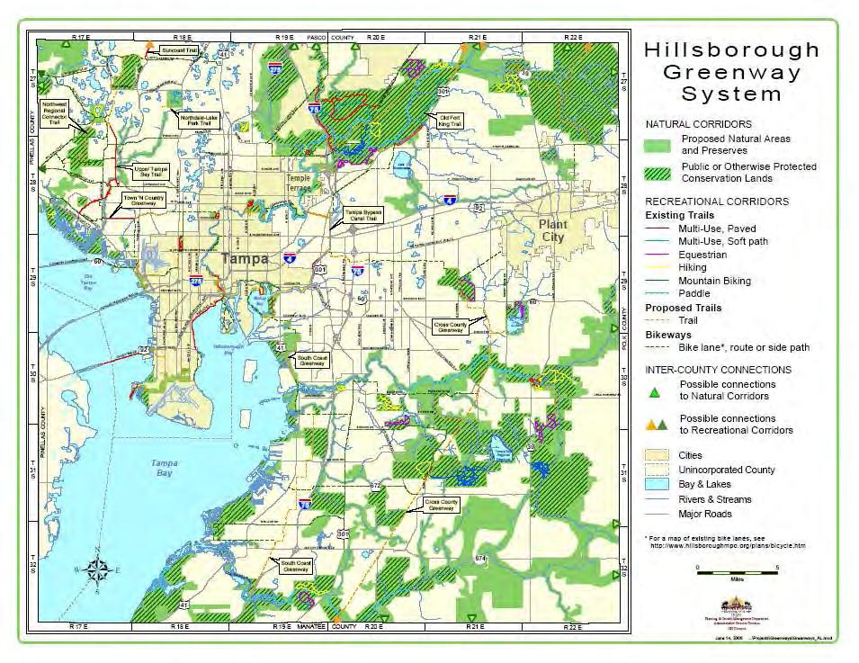
20 The archeologist and the Conservation Services staff recommends that the upland areas and creek shoreline be surveyed in the future. 3.3 Management Measures for Cultural Resources Although all the Preserve has not yet been formally surveyed, and the locations of potential archaeological sites along the creek and the northern portions of the Preserve are not known, the proposed management activities will not likely impact cultural resources. No excavation, grading or other earthwork is proposed in these areas, with the exception of the maintenance of fire breaks. This activity may disturb the upper surface of the soil, but with the exception of the proposed fish pond restoration, no excavation will be undertaken and no impacts to cultural resources are likely. The area where the fish ponds are located has already been completely surveyed, so no impacts to cultural resources will occur as a result of the restoration effort. The creation of the Preserve protects any cultural resources that are present, whether or not their location is known, by prohibiting excavation and mechanical earthwork without first conducting an archaeological survey. 4.0 RECREATIONAL RESOURCES 4.1 Existing Recreational Facilities There are no recreational resources on site currently, and none are proposed at this time. There are extensive restoration plans scheduled to start in the spring of 2007, during which it would be inappropriate and dangerous to allow public access to the site. Upon completion of the restoration activity, and after the plants have matured to a point that the site may attract wildlife, the decision to provide recreational facilities will be addressed. These potential facilities may include creek access, parking, and nature trails. 4.2 Greenways and Trails The South Coast Greenway is the closest trail to the Ekker Nature Preserve. This bike trail is planned to traverse the southern portion of the county, extending from McKay Bay to River Bend Ranch north of the Little Manatee River, using existing roads and proposed bike trails. The trail is planned to come into contact with the southern boundary of the Preserve as it goes down Symmes Road to the TECO powerline right of-way where it continues off road to the southern part of the county. The trail is not planned to utilize the Preserve. Figure 6 shows the Preserve in relation to the proposed trails throughout Hillsborough County, and relevant excerpts of the Hillsborough Greenways Master Plan ( are provided in Appendix E. 17
21 ! 18
22 5.0 RESOURCE MANAGEMENT 5.1 Site Security. The Preserve lies in unincorporated Hillsborough County and is therefore within the jurisdiction of the County Sheriff s Department. The site security residents patrol the Preserve frequently to observe any infractions and then notify the Sheriff if vagrants, poachers, and trespassers are present. Figure 3 shows the access gates from Ekker and Lovegren Roads. These gates remain locked and are posted against trespassing and hunting. 5.2 Exotic Species Management Invasive Exotic Plants The predominant invasive exotic plants known to exist on the Ekker Nature Preserve are Brazilian pepper and air potato. The Brazilian pepper forms a dense growth around the fish farm in the southern part of the site. Air potato occurs along the banks of the creek. These and other exotics will be controlled with herbicide, as are other areas within the county. New species and new infestations can occur frequently and the Conservation Services staff and the site security resident survey the Preserve on a regular basis to prevent new infestations from becoming established. Sites are treated on an as needed basis, prioritized by the staff according to resources available. Exotic plants can be treated by mechanical, physical, chemical or biological methods or combinations of one or more of these methods. Mechanical treatments include the cutting or pulling of the vegetation and often is followed by the use of chemical spraying. Physical treatments include the use of prescribed fire or water impoundment to kill or at least slow the spread of the exotic plants. Chemical treatments are the most widely used and usually most effective methodology. This involves the use of herbicidal sprays applied from back pack sprayers or even from helicopters. Biological controls are the slowest methodology of treatment, but when implemented properly, can be the most effective over the long term. Biological control involves the introduction of a natural predator or pathogen that destroys the exotic species. Biological treatment requires long years of testing to ensure that the introduced control does not create problems in the environment. Treatment methodologies for exotic plant species are continually changing as new herbicides and biological controls are developed. There are numerous references available for types of chemical herbicide application and biological treatment and the science is changing all the time. The Conservation Services Team is committed to using the latest technology and the safest methodology available to reduce existing infestations. Some resources on line include: 19
23 Center for Aquatic and Invasive Plants Web site Florida Exotic Pest Plant Council Web site Identification and Biology of Non-Native Plants in Florida's Natural Areas. K.A. Langeland and K. Craddock Burks. 165 pp IFAS Publication SP 257. Control of Non-Native Plants in Natural Areas of Florida. K.A. Langeland and R.K. Stocker. 34 pp IFAS Publication SP 242. Help Protect Florida's Natural Areas from Non-Native Invasive Plants. K.A. Langeland IFAS Circular The most effective method for the treatment of exotic plant infestations is prevention. This will require periodic monitoring of vulnerable areas in the Preserve and maintenance of all occurrences while they are in the early stage of development Invasive Exotic Animals. A dead green iguana was found on the Preserve, but this is the only exotic animal found to date. There have not been any other exotic animals observed on the Preserve since the land was purchased, but a thorough survey has not been conducted to date. Periodic monitoring to determine the presence of nuisance species is recommended so that removal action may be taken before feral animals become a serious problem. Monitoring can be conducted during routine maintenance events, such as mowing, maintaining firebreaks, and exotic vegetation maintenance and during native wildlife surveys. 5.3 Prescribed Burns The importance of fire Prescribed fire is a land management tool used to restore and maintain fire-dependent ecosystems, enhance forest health, improve wildlife habitat, and prevent dangerous, uncontrolled wildfire by reducing hazardous fuels. Fire promotes healthy ecosystems by clearing out competing vegetation, cycling nutrients into the soil, providing food for wildlife, and stimulating fire-dependent plants to grow and produce seed ( Concerns regarding smoke created by prescribed fire are a priority, even in a sparsely developed area like that around the Preserve. One of the greatest benefits of prescribed fire is that it reduces "fuels" such as the underbrush, branches, pine needles, leaves, and dead plant debris that have built up on the forest floor over time. If fuels are not reduced every few years, wildfires can become intense, hot, and destructive ( 20
24 Because of Florida s long history of lightning fires, many of the state s natural systems are adapted to fire and depend on periodic fire to remain healthy. Prescribed burning is a vital tool for managing pine flatwoods, pine sand hills, and sand pine/oak scrub found in the region. These natural systems shelter many threatened and endangered plant and animal species that rely on fire to survive, such as Florida black bear, Florida scrub-jay, eastern indigo snake, gopher tortoise, and scrub holly. When fire is kept out of these areas, some plant and animal populations decline and eventually disappear (Myers, 1990). Because natural fires can no longer move across the landscape as they did historically, prescribed fire at appropriate intervals is necessary to maintain these unique natural communities. For example, prescribed fire reduces the height of scrub vegetation to a level that is suitable for the Florida scrub jay and opens up sandy areas which allows the jays to store their acorns. Fire also generates fresh seeds, fruits, and native plant growth, providing food for these rare species (Myers, 1990). Many people have expressed concern about the safety of wild animals during prescribed fires. Most wild animals migrate to safety during the relatively slow-moving prescribed fires. Some animals take refuge by moving to unburned or previously burned areas. Small animals seek shelter under logs, in old trees, and in burrows like those of the gopher tortoise. Few animals are killed by fire, especially during the growing season when it s warm and most animals are active. Mammals are rarely killed, and ground nesting birds build new nests and benefit from increased numbers of insects after the fire (Myers, 1990). Prescribed fire is also beneficial to the people of Florida. It prevents wildfires and provides improved wildlife habitat, forest, and grazing land. As Florida s population continues to grow, more and more areas will be developed that will require fire protection services. Prescribed fire is a safe and effective land management tool for preventing wildfires (Myers, 1990) Management Measures for Fire. Prescribed fires are conducted on ELAPP lands as resources become available and when climate conditions are appropriate. Preparation for burns includes the preparation of a burn plan, creation of fire lanes, surveying pre-burn site conditions, and notifying homeowners that may be affected by the burn. Some of these responsibilities will be shared by the Conservation Services team and some occur with the assistance of the state Forestry Department or specialized contractors. No prescribed burns have occurred on this site since its purchase, but burns are currently being planned and will be conducted during the life of this plan. A sample burn plan is included as Appendix F. 21
25 6.0 HABITAT RESTORATION The planted pine and fish farm areas in the Ekker Nature Preserve are scheduled for restoration within the next few years. SWFWMD has prepared a plan and has acquired permits to create a freshwater wetland in the area that the fishponds are now located. The plan will create a mosaic of habitats including 4.74 acres of open water, and 3.1 acres of high marsh vegetated with soft rush, cordgrass, spike rush, flat sedge, buttonbush, and other species tolerant of shallow water inundation. There will be 7.72 acres of low marsh habitat vegetated with pickerel weed, arrowhead, bulrush, and other species tolerant of higher water elevations. The forested wetland areas will total 2.61 acres and will be vegetated with red maple, sweet bay, pop ash, cypress, holly and sweet gum trees, as well as assorted shrubs and ground cover species. There will be 0.64 acres of ephemeral frog ponds vegetated with grasses and rushes located along the eastern boundary, and 0.39 acres of uplands planted with grasses, wax myrtle, and native shrubs. There will be 4.67 acres of four to seven feet high berms located within the uplands that will provide a buffer against the roads on the southern and eastern boundaries. These buffers will also be planted with native grasses, trees, and shrubs such as beauty berry, wax myrtle, saw palmetto, cabbage palm, longleaf pines, red cedars, live and laurel oaks and other species. A copy of the 90% construction plans is included as Appendix G. This project cost approximately $350,000 for design, permitting and construction. The planted pine areas are scheduled for harvesting in the near future, as soon as a restoration plan is complete. The pines will likely be clear cut and the cut areas will be allowed to recruit with native species, while keeping the exotic vegetation under control. The recruited species will likely including longleaf pine and other species that were present prior to the settlement of the site. 7.0 COMPLIANCE 7.1 ELAPP Policies and Ordinances On January 7, 1987, the Board of County Commissioners approved an Environmentally Sensitive Land Ordinance that took effect upon the passage of a referendum on March 3, The voters of Hillsborough County passed the Environmentally Sensitive Lands Referendum by a three to two margin, providing for a one-quarter mil tax over a four-year period to purchase sensitive land in Hillsborough County. The tax was projected to raise approximately twenty-one million dollars in revenues over a four-year period for the purchase or protection of these lands. The Environmental Lands Acquisition and Protection Program (ELAPP) was established for the purpose of acquiring, preserving, and protecting endangered and environmentally sensitive lands, beaches, parks, and recreational lands in Hillsborough County. The purpose of acquiring such lands will be for resource protection; however, all lands shall 22
26 be open for public use and enjoyment to the extent that the County finds such use compatible with the preservation and protection of these lands (ELAPP 2005). The Environmentally Sensitive Land Ordinance is provided as Appendix H. In 1997, the Parks ordinance (78-8) was repealed and replaced with Ordinance to provide additional protection to the park and conservation lands of Hillsborough County. This ordinance provides regulations that conformed to those of the state and federal government with respect to public lands. This ordinance is provided in its entirety in Appendix H. 7.2 Compliance with Comprehensive Plans The Ekker Preserve will assist Hillsborough County in implementing the goals, objectives and policies of the Conservation and Aquifer Recharge Element, Future Land Use Element, and Recreation and Open Space Element of the County s Comprehensive Plan. The preservation of wildlife habitats and the development of public recreation and environmental conservation activities on the Preserve will help to accomplish or further enhance the following goals and objectives. Copies of the relevant elements of the County s Comprehensive Plan are included as Appendix I 7.3 Proposed Expansion Opportunities There are two parcels (Parcels #1 and #2, See Appendix J) along the northeastern boundary of the Preserve that have been approved for purchase by ELAPP. These parcels total approximately 0.85 acres and have been excavated to create a ditch which now supports a dense cover of primrose willow, Carolina willow and other exotic nuisance plants. Other potential purchases are located across the creek from the Ekker Nature Preserve. Parcels #3 and #4 (See Appendix J) are owned by Pat and Judy Milam, owners of a native plant nursery. The two parcels total almost 8 acres and appear to be in relatively good shape from the aerial photography and they would contribute to the riparian corridor. The sites appear to have structures on them which can be easily removed. Parcel #5 (See Appendix J) is another predominantly undeveloped parcel across the creek from the Ekker Nature Preserve that may be available for purchase. It is about 4 acres and is densely forested. The remaining lands around the Preserve are intensive farm lands or residential properties and would not qualify for ELAPP purchase. SWFWMD had identified two parcels of land adjacent to the Ekker Nature Preserve for purchase in the 2005 update of the Florida Forever Work Plan. The parcels were located on the north and west sides of the Preserve and would have enhanced the habitat and recreation value of the Preserve considerably. Unfortunately land values in Hillsborough County have increased to such an extent and land is in such demand that the parcels were sold to developers before SWFWMD could buy them (Brandt Henningsen, personal communication, 2006). 23
27 8.0 SUMMARY OF MANAGEMENT GOALS AND OBJECTIVES Listed below are the goals and objectives proposed for the 10-year period of this management plan. These goals and objectives are not in any prioritized order, but it is likely that the treatment of exotic vegetation will take precedence over the other objectives. TABLE 4 PROPOSED MANAGEMENT GOALS AND OBJECTIVES FOR EKKER PRESERVE OBJECTIVE SCHEDULE ESTIMATED COST Control exotic vegetation (annual $600.00) Ongoing $6, Conduct prescribed burns (3 $2,000) Ongoing $6, Re-fence the east boundary and other areas as needed ($700/yr) Ongoing $7, Maintenance of structures ($2,000/yr) Ongoing $20, Posting costs of signs, man-hours, etc. ($400/yr) Ongoing $4, Law enforcement paid to state and local law officers ($4,200/yr) Ongoing $42, Habitat management (roads, culverts, reforestation) ($1,500/yr) Ongoing $15, Monitoring, inventories ($850.00/yr) Ongoing $8, Restoration (design, permitting, construction) Total $108, The items above include those listed on a budget submitted to the SWFWMD on an annual basis. Examples of those budgets are provided in Appendix K. Hillsborough County receives 50% reimbursement for management costs through an agreement with SWFWMD. The treatment of exotic vegetation should be conducted on an annual basis to control the invasive vegetation and prevent impacts to habitat. If the treatments occur annually and are successful, then less herbicide and fewer treatments will be needed in the future. The costs of wildlife surveys and monitoring should be absorbed into the annual budgets for ELAPP as part of the land management requirements. Additional studies may be funded by grants from environmental agencies and academia. 24
28 9.0 REFERENCES Cox, J. R. Kautz, M. MacLaughlin, and T. Gilbert Closing the Gaps in Florida s Wildlife Habitat Conservations System. Florida Game and Freshwater Fish Commission, Tallahassee, Florida Cox, J. and R. Kautz Habitat Conservation Needs of Rare and Imperiled Wildlife in Florida. Florida Fish and Wildlife Conservation Commission, Tallahassee, Florida. Exotic Pest Plant Council, List of Florida s Most Invasive Species. EPPC Committee on Invasive Species. Florida Fish and Wildlife Conservation Commission, Comprehensive Wildlife Conservation Strategy, Planning for the Future for Florida s Wildlife, Second Draft. Florida Fish and Wildlife Conservation Commission, Division of Wildlife, Bureau of Nongame Wildlife, Official Lists of Florida s Endangered Species, Threatened Species, and Species of Special Concern. Henningsen, Brandt, Senior Environmental Scientist, SWFWMD SWIM Program, Personal communication regarding land acquisition in the Ekker Nature Preserve vicinity. Hillsborough County Parks, Recreation, and Conservation Department, ELAPP Site Assessment Team, Report to the County Commissioners. Recommendations concerning: Environmental Lands Acquisition and Protection Program, (17 TH Year), August Humphrey, Stephen R. Editor, Rare and Endangered Biota of Florida: Volume I. Mammals. University Press of Florida, Gainesville, Florida. Johnson, Pete, Personal communication, resident of Ekker Preserve. Kale, H.W. II, and D.S. Maehr, Florida's Birds - A Handbook and Reference. Pineapple Press, Sarasota, Florida. Langeland, Ken, editor, no date. Exotic Woody Plant Control. Florida Cooperative Extension Service, University of Florida, Institute of Food and Agricultural Sciences, and Exotic Pest Plant Control Council. Moler, Paul E., editor, Rare and Endangered Biota of Florida: Volume III, Amphibians and Reptiles. University Press of Florida, Gainesville, Florida. 25
Hillsborough County s E.L.A.P.P Program
 Hillsborough County s E.L.A.P.P Program What is E.L.A.P.P? Environmental Lands Acquisition and Protection Program History of E.L.A.P.P. - Voter-approved program initiated in 1987; extended in 1990 and
SW-71 BOYD HILL NATURE PRESERVE MITIGATION PLAN
 SW-71 BOYD HILL NATURE PRESERVE MITIGATION PLAN BACKGROUND INFORMATION Project SWIM? Aquatic Control? Exotic Control? Mitigation Bank? Type No No Yes No Mitigation Wetland and upland enhancement Type Landowner
SW-74 SERENOVA PRESERVE SITES 2, 3, 4, 8 MITIGATION PLAN
 SW-74 SERENOVA PRESERVE SITES 2, 3, 4, 8 MITIGATION PLAN BACKGROUND INFORMATION Project SWIM? Aquatic Control? Exotic Control? Mitigation Bank? Type No No No No Mitigation Restoration and enhancement Type
IS YOUR NEIGHBOR. Landscaping to Reduce Wildfire Risk. South Florida Edition
 IS YOUR NEIGHBOR Landscaping to Reduce Wildfire Risk South Florida Edition F Wildland/Urban Interface For additional information: www.firewise.org www.floridaforestservice.com Contents 4 Fire in Florida
WETLANDS AND OPEN WATERS Compensatory Mitigation Definitions of Factors
 Adverse effects as used in this section of the SOP means any adverse ecological effect on wetlands or areas of open water. Those effects, or impacts, include filling, excavating, flooding, draining, clearing,
1. GENERAL DESCRIPTION OF LAND USE / COVER TYPES (SEE GENERAL DESCRIPTIONS ON PAGE 7) A 2. ADJACENT LANDS & EASEMENTS 3. FAMILY AGRICULTURAL LEGACY
 A 2. ADJACENT LANDS & EASEMENTS 3. FAMILY AGRICULTURAL LEGACY") CONSERVATION EASEMENT PROJECT: COUNTY: NAME OF LANDOWNER: CELL/OFFICE PHONE: NAME OF FARM / SITE MANAGER: CELL/OFFICE PHONE: GENERAL DESCRIPTION OF LAND USE / COVER TYPES (SEE GENERAL DESCRIPTIONS ON PAGE
CONSERVATION EASEMENT PROJECT: COUNTY: NAME OF LANDOWNER: CELL/OFFICE PHONE: NAME OF FARM / SITE MANAGER: CELL/OFFICE PHONE: GENERAL DESCRIPTION OF LAND USE / COVER TYPES (SEE GENERAL DESCRIPTIONS ON PAGE
Nez Perce National Forest Moose Creek Ranger District
 United States Department of Agriculture Forest Service Nez Perce National Forest Moose Creek Ranger District 831 Selway Road Kooskia, ID 83539 208 926-4258 TTY 208 926-7725 File Code: 1950 Date: Dec 30,
CONSERVATION 20/20 OVERVIEW. Cathy Olson, Conservation Lands Manager Lee County Department of Parks and Recreation
 CONSERVATION 20/20 OVERVIEW Cathy Olson, Conservation Lands Manager Lee County Department of Parks and Recreation What is Conservation 20/20? Lee County s current environmentally sensitive land acquisition
Chapter 13: Wildlife and Vegetation
 Chapter 13: Wildlife and Vegetation Introduction and Setting Nevada County contains an extremely wide range of plants, animals and habitat types. With topographic elevations ranging from 300 feet in the
Dan Hipes, Chief Scientist
 Gopher Tortoise Survey at selected State Forests in Northeastern Florida: Ralph E. Simmons State Forest, Cary State Forest, Etoniah Creek State Forest, Belmore State Forest, Blue Springs Longleaf tract
3.6 Riparian Ecosystem Wildlife
 3.6 Riparian Ecosystem Wildlife 3.6.1 Introduction and Methodology Riparian areas and associated wetlands are widely recognized for the significant and diverse roles they play in the landscape. They clean
Proposed Wildlife Habitat Restoration Project At Walking Iron Wildlife Area August 6, 2015
 Proposed Wildlife Habitat Restoration Project At Walking Iron Wildlife Area August 6, 2015 Walking Iron County Wildlife Area is 898 acres situated in the Town of Mazomanie between Walking Iron County Park
GENERAL GUIDELINES FOR CONDUCTING THREATENED AND ENDANGERED SPECIES SURVEYS IN THE PINELANDS AREA. March 25, 2006 INTRODUCTION
 GENERAL GUIDELINES FOR CONDUCTING THREATENED AND ENDANGERED SPECIES SURVEYS IN THE PINELANDS AREA March 25, 2006 INTRODUCTION This document is intended to provide general guidance for use in conducting
Chapter 10 Natural Environment
 Chapter 10 Natural Environment Existing Conditions The Natural Environment Element addresses the protection, conservation, preservation, and restoration of the natural resources the Bayview Ridge Subarea,
Science Plan. Executive Summary. Introduction
 Science Plan Executive Summary This Science Plan will establish and define the focus of the Peninsular Florida Landscape Conservation Cooperative (PFLCC) science investments. The data and products derived
Nancy L. Young, Forester USAID/USDA Natural Resources Conservation Service
 Forest Management Nancy L. Young, Forester USAID/USDA Natural Resources Conservation Service Material translated by: Mohammadullah Karimi, Training & Liaison Officer Afghan Conservation Corps Managing
Conservation of Biological Diversity
 Conservation of Biological Diversity Images courtesy of US Fish and Wildlife Service Auburn University School of Forestry and Wildlife Sciences Nature s Limits Ultimate constraints are natural or Ecosystem
Long-term Management Plan For The Mitigation Bank
 Note: The California multi-agency Project Delivery Team developed this general outline to assist in the development of the Long-term Management Plan for mitigation banks. Objectives and tasks are provided
New Jersey Forest Stewardship Program Spatial Analysis Project Map Products And Data Layers Descriptions
 New Jersey Forest Stewardship Program Spatial Analysis Project 2007 Map Products And Data Layers Descriptions 01/07 NJ Forest Stewardship Program (FSP) Spatial Analysis Project (SAP) Methodology Project
Wildlife Management Intensity Standards
 Habitat Control Practices Required Intensity Description Grazing Management The planned manipulation of livestock numbers and grazing intensities to increase food, The planned manipulation of livestock
CITY OF PALM BEACH GARDENS COMPREHENSIVE PLAN CONSERVATION ELEMENT SUPPORT DOCUMENT. Prepared by: The City of Palm Beach Gardens
 CITY OF PALM BEACH GARDENS COMPREHENSIVE PLAN CONSERVATION ELEMENT SUPPORT DOCUMENT Prepared by: The July 2016 I. INTRODUCTION The continues to be committed to protect and preserve the City s natural resources
DECISION MEMO. Non-Commercial Thinning on the Ocala National Forest (PALS project # 39238)
") Decision DECISION MEMO Non-Commercial Thinning on the Ocala National Forest (PALS project # 39238) USDA Forest Service Ocala National Forest Lake, Marion, and Putnam County, Florida Based on the analysis
Decision DECISION MEMO Non-Commercial Thinning on the Ocala National Forest (PALS project # 39238) USDA Forest Service Ocala National Forest Lake, Marion, and Putnam County, Florida Based on the analysis
SKIBO PROJECT SCOPING REPORT Laurentian Ranger District, Superior National Forest
 SKIBO PROJECT SCOPING REPORT Laurentian Ranger District, Superior National Forest I. Introduction The Laurentian Ranger District of the Superior National Forest is proposing management activities within
Appendix J. Forest Plan Amendments. Salvage Recovery Project
 Forest Plan Amendments Salvage Recovery Project APPENDIX J Lynx and Old Growth Forest Plan Amendments CHANGES BETWEEN DRAFT EIS AND FINAL EIS Changes in Appendix J between the Draft and Final EIS include:
WATERSHED. Maitland Valley. Report Card 201
 Maitland Valley WATERSHED Report Card 201 The Maitland Valley Conservation Authority has prepared this report card as a summary on the state of our forests, wetlands, surface water, and ground water resources.
Practice Plan for Sparta Mountain Wildlife Management Area (WMA) Stand 33: Restore Old Growth
 Stand 33: Restore Old Growth") Practice Plan for Sparta Mountain Wildlife Management Area (WMA) Stand 33: Restore Old Growth This practice plan addresses a general activity provided for in year 2017-2018 of the management schedule within
Practice Plan for Sparta Mountain Wildlife Management Area (WMA) Stand 33: Restore Old Growth This practice plan addresses a general activity provided for in year 2017-2018 of the management schedule within
Surface Water and Non-Wetland Surface Waters Delineation and Classification pursuant Chapter F.A.C.
 Surface Water and Non-Wetland Surface Waters Delineation and Classification pursuant Chapter 62-340 F.A.C. What are Waters? 373.019 F.S. Definitions (20) Water or waters in the state means any and all
Land use in Hardee County : prepared by Center for Economic Development Research, College of Business Administration, University of South Florida
 University of South Florida Scholar Commons College of Business Publications College of Business 2-1-2003 Land use in Hardee County : prepared by Center for Economic Development Research, College of Business
Introduction. Property Boundary and Survey Evidence
 Introduction The Peacham Town Forest is approximately 190 acres of land located in the Northwest corner of the town, close to the town line with Cabot. The tract is the former Ike Peck farm and was acquired
Developing forestry practices. Managing for Timber and Wildlife Diversity NATIONAL WILD TURKEY FEDERATION PRE-HARVEST PLANNING:
 Managing for Timber and Wildlife Diversity by Joe McGlincy NWTF WILDLIFE BULLETIN NO.15 RON BRENNEMAN NATIONAL WILD TURKEY FEDERATION Developing forestry practices that could potentially benefit all wildlife
Crow s Foot Conservation Area Feasibility Study
 Crow s Foot Conservation Area Feasibility Study Site Opportunities Presentation Trust For Public Land PRESENTED BY SmithGroup JJR August, 2002 McHenry County Conservation District Boone County Conservation
Managing Forested Wildlife Habitats
 Managing Forested Wildlife Habitats Matt Tarr Wildlife Specialist UNH Cooperative Extension What management activities are right for a given property? There is no one right way to manage any piece of land
University of Florida Conservation Areas Land Management Plan Trillium Slope (Golf Course Woods)
") University of Florida Conservation Areas Land Management Plan Trillium Slope (Golf Course Woods) Introduction Trillium Slope (Golf Course Woods) is a 4.9-acre Conservation Area named after a plant that
University of Florida Conservation Areas Land Management Plan Trillium Slope (Golf Course Woods) Introduction Trillium Slope (Golf Course Woods) is a 4.9-acre Conservation Area named after a plant that
Habitat Conservation Planning for the Threatened Florida Scrub Jay (Aphelocoma. coerulescens) in Charlotte County, Florida
 in Charlotte County, Florida") Habitat Conservation Planning for the Threatened Florida Scrub Jay (Aphelocoma coerulescens) in Charlotte County, Florida Presented by Dr. Reed Bowman (Archbold Biological Station) Andy Stevens (Charlotte
Habitat Conservation Planning for the Threatened Florida Scrub Jay (Aphelocoma coerulescens) in Charlotte County, Florida Presented by Dr. Reed Bowman (Archbold Biological Station) Andy Stevens (Charlotte
MANITOBA ENVIROTHON WATER AND AQUATIC ECOSYSTEMS
 MANITOBA ENVIROTHON WATER AND AQUATIC ECOSYSTEMS Outcome Water and Aquatic Ecosystems as Resources Properties of Water, Water Bodies and Watersheds, and Aquatic Species Identification A1 A2 A3 A4 A5 A6
RIPARIAN FOREST BUFFER
 RIPARIAN FOREST BUFFER (Acres) Code 391 Natural Resources Conservation Service Conservation Practice Standard I. Definition An area predominantly of trees and shrubs that functions as a vegetated ecotone
Hubbard Lake State Game Area Master Plan
 Hubbard Lake State Game Area Master Plan MICHIGAN DEPARTMENT OF NATURAL RESOURCES WILDLIFE DIVISION BRIAN PICCOLO AUGUST 2017 Intended Purpose and General Management Direction Hubbard Lake State Game Area
For the property described as: Property Owner: Name. Phone Number. Mailing Address. City. Report Year:
 Timber Management Plan For the property described as: Property Owner: Name Phone Number Mailing Address City State Zip Report Year: (This template is provided to assist Cherokee County land owners who
Draw disruptive, stabilizing, and directional selection on the board. Explain disruptive selection using an example. What effects speciation most?
 Draw disruptive, stabilizing, and directional selection on the board. disruptive selection using an Disruptive selection is when the average physical characteristic of a population is not beneficial. Example:
Fire Management CONTENTS. The Benefits of Guidelines...3 Considerations...4
 Fire Management CONTENTS Fire Management 1 Introduction...3 The Benefits of Guidelines...3 Considerations...4 Planning...5 Burn Plan Development...5 Operational Activities...8 Pre-Ignition Activities...8
SWFSWG Land Management Field Trip Buckingham Trails and Telegraph Creek preserves, Lee County 10/26/2010
 SWFSWG Land Management Field Trip Buckingham Trails and Telegraph Creek preserves, Lee County 10/26/2010 Participants Last Name First Name Organization/Agency Name Abbreviation Balcer Natalie DEP NB Bradshaw
RULES OF THE ENVIRONMENTAL PROTECTION COMMISSION OF HILLSBOROUGH COUNTY CHAPTER 1-11 WETLANDS
 RULES OF THE ENVIRONMENTAL PROTECTION COMMISSION OF HILLSBOROUGH COUNTY CHAPTER 1-11 WETLANDS PART I 1-11.01 Intent 1-11.02 Definitions 1-11.03 Identification of Wetlands 1-11.04 Wetland and Other Surface
Forestry Establishment and Wildlife Conservation Programs and Assistance
 The Upper Big Blue NRD Forestry Department: Forestry Establishment and Wildlife Conservation Programs and Assistance District Forestry Under the NRD s seedling sales program, tree and shrub stock is provided
Background. AEM Tier 2 Worksheet Stream & Floodplain Management. Glossary
 AEM Tier 2 Worksheet Stream & Floodplain Management Glossary Bankfull Stage: The stage at which water starts to flow over the flood plain; the elevation of the water surface at bankfull discharge. (This
SUBJECT: Charter Amendment vs Tree Ordinance (Chapter 656 Part 12) Guideline for Site Clearing/Tree Removal Permit Application
 Guideline for Site Clearing/Tree Removal Permit Application") December 28, 2015 MEMORANDUM BULLETIN L02-15 TO: FROM: All Interested Parties Thomas H. Goldsbury, P.E., C.B.O. LEED A.P. Chief, Building Inspection Division SUBJECT: Charter Amendment vs Tree Ordinance
December 28, 2015 MEMORANDUM BULLETIN L02-15 TO: FROM: All Interested Parties Thomas H. Goldsbury, P.E., C.B.O. LEED A.P. Chief, Building Inspection Division SUBJECT: Charter Amendment vs Tree Ordinance
BMPs TO CONSERVE WOODED AREAS AT THE SUBDIVISION LEVEL
 BMPs to Conserve Wooded Areas 31 BMPs TO CONSERVE WOODED AREAS AT THE SUBDIVISION LEVEL Audience This section is primarily directed toward: local units of government, landowners and developers, builders
Wetlands Project Guidance
 HABITAT Wetlands Project Guidance Stakeholder Informed Introduction Wetlands are lands saturated with water permanently or seasonally. Wetlands are typically defined by three characteristics: 1) The area
VIDEO: Freshwater Wetlands
 VIDEO: Freshwater Wetlands Adapted from: Freshwater Wetlands-Life at the Waterworks. Educational Media Corporation / North Carolina State Museum of Natural Sciences. Introduction to Wetlands Grade Level:
TORCH LAKE TOWNSHIP WATER QUALITY ACTION PLAN
 TORCH LAKE TOWNSHIP WATER QUALITY ACTION PLAN Elk-River-Chain-of-Lakes Gaps Analysis Project The Watershed Center Grand Traverse Bay Tip of the Mitt Watershed Council Michigan Department of Natural Resources
Intermittent Stream Reclamation
 Reclamation About Mosaic Reclamation > In carrying out its mission to help the world grow the food it needs, Mosaic couples recovery of phosphate resources with respect of the phosphate-rich land that
RIPARIAN CORRIDOR STUDY FINAL CITY CREEK MANAGEMENT PLAN TABLE OF CONTENTS
 TABLE OF CONTENTS 1.0 INTRODUCTION... 1-1 Riparian Corridor Study and Management Plan Goals... 1-1 Study Area... 1-2 Importance and Functions of Riparian Corridors... 1-2 Habitat for Mammals, Birds, and
Linking TEK, Outreach, and Science to Protect Everglades Wetlands. Water Resources Department Marta Reczko, Water Resources Manager
 Linking TEK, Outreach, and Science to Protect Everglades Wetlands Water Resources Department Marta Reczko, Water Resources Manager Everglades Facts The Everglades is a marsh, a region, a watershed, an
The Safe Harbor Program for Red-cockaded Woodpeckers in North Carolina
 U.S. Fish & Wildlife Service The Safe Harbor Program for Red-cockaded Woodpeckers in North Carolina Ralph Costa Provides assistance and benefits to private landowners The red-cockaded woodpecker is an endangered
City of Winter Haven Water Sustainability Program. Mike Britt, P.E., Natural Resources Division
 Florida Stormwater Association EXCELLENCE AWARD for STORMWATER PROGRAMS and PROJECTS NOMINATION FORM I. Nomination Information Nomination Category (please check only one box): Program (Department/Division)
Sustainable Non-Agriculture Land Management
 Forest, Wetlands and Habitat Verification Checklist A boxed risk level indicates the level required for environmental assurance verification. Bold black print indicates a violation of state or federal
NJDEP Regulations that impact or soon will impact agricultural operations. April 1, 2007 Horses 2007
 NJDEP Regulations that impact or soon will impact agricultural operations. April 1, 2007 Horses 2007 Peter L. Kallin, Ph.D., P.W.S. Phone: 732-499-3600 Ext. 237 E-mail: pkallin@aesop.rutgers.edu www.water.rutgers.edu
Field Sparrow. Appendix A: Birds. Spizella pusilla. New Hampshire Wildlife Action Plan Appendix A Birds-308
 Field Sparrow Spizella pusilla Federal Listing State Listing Global Rank State Rank Regional Status N/A N/A G5 S3 Very High Photo by Pamela Hunt Justification (Reason for Concern in NH) Populations of
RIPARIAN PROTECTION Questions & Answers
 RIPARIAN PROTECTION Questions & Answers 1. What is a riparian corridor and why is it important? Answer: A riparian corridor is a space on both sides of a stream or around a lake or wetland. The corridor
CADILLAC FOREST MANAGEMENT UNIT
 Created on 06/22/2005 8:30 AM Comp004.doc Page 1 of 2 CADILLAC FOREST MANAGEMENT UNIT COMPARTMENT REVIEW PRESENTATION COMPARTMENT #4 ENTRY YEAR: 2007 Compartment Acreage (GIS Acres): 1913 County: Lake
SANTA CLARA Protections in place:
 SANTA CLARA s in place: General Plan Language Specific Tree Retention/ Replacement The Tree prohibits cutting 12 dbh trees on hillside zone parcels
CenterPlace. SW Florida International Airport Cemex Mine. Meridian Center IHub. Gulf Coast Town Center. Miromar Lakes. Youngquist Mine FGCU
 SW Florida International Airport Cemex Mine Meridian Center IHub Gulf Coast Town Center CenterPlace Miromar Lakes FGCU Youngquist Mine University Highlands Grandezza Corkscrew Woods Preserve at Corkscrew
Forensic Forestry Reading the Land
 Principles of Forest Ecology and Management or Forensic Forestry Reading the Land Jonathan Kays University of Maryland Extension Where Do We Start? Think Like A Plant Act Like A Plant Thinking and Acting
POLICY FOR NATURAL RESOURCE MANAGEMENT AREAS
 POLICY FOR NATURAL RESOURCE MANAGEMENT AREAS I. POLICY STATEMENT Auburn University's (the University's) "Policy for Natural Resource Management Areas" implements the Campus Master Plan Land Use Element
Flagler County Property Appraiser Agricultural Classification
 Flagler County Property Appraiser Agricultural Classification What is an Agricultural Classification? Agricultural Classification, more commonly known as Greenbelt Classification, is a classification of
Hat Creek Planning Unit. Fish, Plant, and Wildlife Habitat. LCP Volume II Supporting Analysis for Recommendations
 Hat Creek Planning Unit Fish, Plant, and Wildlife Habitat Conduct surveys of the planning unit to identify biological resources and enable their protection. Though a partial survey of botanical resources
Wisconsin s Green Fire: Voices for Conservation
 Analysis of proposal to remove state regulatory oversight of non-federal wetlands in legislation: AB547 / SB600 December 18, 2017 Legislation Description: The following is an excerpt of the analysis of
ALABAMA S BEST MANAGEMENT PRACTICES. Protection of Water Quality During Timber Harvesting
 ALABAMA S BEST MANAGEMENT PRACTICES Protection of Water Quality During Timber Harvesting Water Quality Responsibility Landowners and/or involved professional forestry practitioners such as: Forest resource
Sustaining Terrestrial Biodiversity: Saving Ecosystems and Ecosystem Services
 LIVING IN THE ENVIRONMENT, 18e G. TYLER MILLER SCOTT E. SPOOLMAN 10 Sustaining Terrestrial Biodiversity: Saving Ecosystems and Ecosystem Services Core Case Study: Costa Rica A Global Conservation Leader
Habitat Restoration, Longleaf Pine Forests, and the Flatwoods Salamander. Goals of Today s Talk. Habitat Restoration. Habitat Restoration
 Habitat Restoration, Longleaf Pine Forests, and the Flatwoods Salamander Kenny Wray Goals of Today s Talk Introduce you to the science of Restoration Ecology. Give you examples of the theory and processes
Pea Ridge Battlefield Prescribed Burning. Introduction. Prescribed burns involve the burning of controlled areas as a means of improving ecology and
 Jocee Norton Bethany Hollis Macey Brooks Rebecca Krein Empacts Project Cecil 4/15/14 Pea Ridge Battlefield Prescribed Burning Introduction Prescribed burns involve the burning of controlled areas as a
Natural Resources KEY ISSUES SCENIC AREA ACT PROVISIONS CHAPTER 3. not adversely affect natural resources [Section 6(d)(3)].
![Natural Resources KEY ISSUES SCENIC AREA ACT PROVISIONS CHAPTER 3. not adversely affect natural resources [Section 6(d)(3)].](/thumbs/78/77781439.jpg "Natural Resources KEY ISSUES SCENIC AREA ACT PROVISIONS CHAPTER 3. not adversely affect natural resources [Section 6(d)(3)].") CHAPTER 3 Natural Resources Climate, geology, soils, and other environmental factors combine to make the Gorge rich in natural resources. For this chapter, natural resources mean wetlands, streams, ponds
CHAPTER 3 Natural Resources Climate, geology, soils, and other environmental factors combine to make the Gorge rich in natural resources. For this chapter, natural resources mean wetlands, streams, ponds
LAND AND USE. Figure 2. Land cover in Rhode Island, Forest land. Nonforest land and smaller forest patches predominate in the area surrounding
 Mountain laurel Kalmia latifolia Figure 2. Land cover in Rhode Island, 1992. Forest land Developed land Agricultural land Other land Water Source: U.S. Geologic Survey, National Land Cover Data LAND AND
8/5/2011. Lesson Overview. Disturbance/Fragmentation. Shifting Mosaic. Number one cause of biodiversity loss. Types of disturbance. - Scale, frequency
 Lesson Overview Disturbances Fragmentation Types Measuring Corridors Effects Texas Example 1 Shifting Mosaic Landscape a shifting mosaic. - Made up of patches in different phases of successional development.
Biophysical Indicators of Longleaf Pine Sandhill Change. Ryan R. Jensen Department of Geography, Geology, and Anthropology
 Biophysical Indicators of Longleaf Pine Sandhill Change Ryan R. Jensen Department of Geography, Geology, and Anthropology Sandhills Species Long-leaf pine Turkey oak Wiregrass Extremely rich herbaceous
PHYSICAL ENVIRONMENT FUNCTION Natural Resources Department
 Director s Background James T. Evans III, M.S. PHYSICAL ENVIRONMENT FUNCTION Natural Resources Department Director Evans has been employed with the City of Sanibel for more than 14 years and has over 17
Chapter 30. Conserving Earth s Biodiversity
 Chapter 30 Conserving Earth s Biodiversity Chapter 30 At a Glance What Is Conservation Biology? Why Is Biodiversity Important? Is Earth s Biodiversity Diminishing? What Are the Major Threats to Biodiversity?
DECISION NOTICE AND FINDING OF No SIGNIFICANT IMPACT HOPKINS FIRE SALVAGE
 DECISION NOTICE AND FINDING OF No SIGNIFICANT IMPACT HOPKINS FIRE SALVAGE DECISION U.S. FOREST SERVICE OCALA NATIONAL FOREST SEMINOLE RANGER DISTRICT MARION COUNTY, FLORIDA Based upon my review of the
Lesson 2-2: Riparian Zones
 2-14 Lesson 2-2: Riparian Zones Time of Lesson: 1 hour Rationale: The purpose of this lesson is to define what a riparian zone is and link its importance for fish and other animals, and humans, and the
Florida Fish & Wildlife Conservation Commission
 Florida Fish & Wildlife Conservation Commission Marsha Ward District Biologist Everglades and Francis S. Taylor WMAs Jenny Ketterlin Lead Area Biologist Holey Land and Rotenberger WMAs Dan Castillo Biological
VOLUSIA COUNTY WILDLAND/URBAN INTERFACE WILDFIRE HAZARD ASSESSMENT GUIDE
 VOLUSIA COUNTY WILDLAND/URBAN INTERFACE WILDFIRE HAZARD ASSESSMENT GUIDE The Volusia County Wildland/Urban Interface Wildfire Hazard Assessment Guide is a compilation of work by The Nature Conservancy
Managing Forests For Wildlife 3/13/2017 1
 Managing Forests For Wildlife 3/13/2017 1 Why? Primarily Food. Acorns 142 calories/ounce. 9 grams of fat. 15 grams carbohydrate 2 grams protein Wildlife SuperFood Acorns can compose more than 75 percent
P ARISH OF EAST B ATON ROUGE, L OUISIANA BREC S TRATEGIC P LAN
 CHAPTER 9 CULTURAL, HISTORICAL AND NATURAL RESOURCE MANAGEMENT PLAN INTRODUCTION This chapter is a digest version of a Natural Resource, Cultural and Historical Document authored by BREC Staff over the
Silvicultural practices in the restoration of degraded ecosystems
 Silvicultural practices in the restoration of degraded ecosystems Current conditions reflect site history and physical environment Altered fire regimes, including exclusion Forest management, including
Tim Hayden, Yurok Tribe Natural Resources Division Mat Millenbach, Western Rivers Conservancy Sarah Beesley, Yurok Tribal Fisheries Program
 BLUE CREEK FOREST SANCTUARY: RESTORING OLD GROWTH FOREST ECOSYSTEM FUNCTION, PROTECTING SALMON, WILDLIFE, AND TRADITIONAL- LIFE WAYS AND CULTURE IN THE FACE OF CLIMATE CHANGE Tim Hayden, Yurok Tribe Natural
Huron-Manistee National Forests Mio Ranger District 107 McKinley Road Mio, MI 48647
 United States Department of Agriculture Forest Service Huron-Manistee National Forests Mio Ranger District 107 McKinley Road Mio, MI 48647 989-826-3252 (Voice) 989-826-6073 (Fax) Dial 711 for relay service
Ecology & Management of Cheatgrass
 Ecology & Management of Cheatgrass Dr. Jay Norton, Soils Specialist University of Wyoming Land Reclamation Basics for Energy Development in Northeastern Wyoming February 3, 2009 Overview Exotic Exotic
RIPARIAN CORRIDOR STUDY FINAL PARLEYS CREEK MANAGEMENT PLAN TABLE OF CONTENTS
 TABLE OF CONTENTS 1.0 INTRODUCTION... 1-1 Riparian Corridor Study and Management Plan Goals... 1-1 Study Area... 1-2 Importance and Functions of Riparian Corridors... 1-2 Habitat for Mammals, Birds, and
Wildlife Habitat Management on State Land
 Aspen, Paper Birch Wildlife Habitat Management on State Land Aspen and paper birch are typically managed by using even-aged management (clear cutting) with retention of scattered older trees or patches
EAST TORRANCE SOIL AND WATER CONSERVATION DISTRICT. LONG RANGE PLAN July 1, 2009 June 30, 2019
 EAST TORRANCE SOIL AND WATER CONSERVATION DISTRICT LONG RANGE PLAN July 1, 2009 June 30, 2019 INTRODUCTION The East Torrance Soil and Water Conservation District covers 1,142,028 acres of land in Torrance
Natural Communities of Clay Soils in the Lake Champlain Basin
 Natural Communities of Clay Soils in the Lake Champlain Basin Marc Lapin, Forest Ecologist Middlebury College Program in Environmental Studies & Champlain Valley Clayplain Forest Project What Makes Clayplain
719 Griswold, Suite 820 Detroit, MI DANVERS POND DAM REMOVAL AND STREAM RESTORATION PROJECT
 Great Lakes Restoration Initiative Grant Final Report US EPA Grant GL 00E006 43 October, 2013 Valley Woods Wetland Southfield Lola Valley Grow Zone Wayne County Parks Venoy Park Grow Zone Wayne County
DEPARTMENT OF THE ARMY JACKSONVILLE DISTRICT CORPS OF ENGINEERS PRINCESS PALM AVENUE, SUITE 120 TAMPA, FLORIDA
 DEPARTMENT OF THE ARMY JACKSONVILLE DISTRICT CORPS OF ENGINEERS 10117 PRINCESS PALM AVENUE, SUITE 120 TAMPA, FLORIDA 33610 REPLY TO ATTENTION OF May 8, 2015 Regulatory Division South Permits Branch Tampa
Lake Britton Planning Unit. Fish, Plant, and Wildlife Habitat LAKE BRITTON PLANNING UNIT
 LAKE BRITTON PLANNING UNIT Pit-McCloud River Watershed Lake Britton Planning Unit Fish, Plant, and Wildlife Habitat Conduct surveys of lands outside the FERC boundary to identify biological resources and
Environment & Conservation Introduction
 Environment & Conservation Introduction Anacortes is blessed with an abundance of natural beauty. Residents identify marine shorelines, streams, lakes, forested areas, and other natural features as defining
Ontario Envirothon LEARNING OBJECTIVES. Ontario Envirothon Learning Objectives
 Ontario Envirothon LEARNING OBJECTIVES Updated Fall 2015 5 Contents Contents... 6 Overall Objectives... 7 Aquatic Ecology... 8 Specific Objectives... 8 Overall Objectives... 8 Application/Analysis... 9
ATLANTA FOREST MANAGEMENT UNIT COMPARTMENT REVIEW PRESENTATION COMPARTMENT # 129 ENTRY YEAR: 2008
 ATLANTA FOREST MANAGEMENT UNIT COMPARTMENT REVIEW PRESENTATION COMPARTMENT # 9 ENTRY YEAR: 2008 Compartment Acreage: 1615 County: Presque Isle Revision Date: December 19, 2006 Stand Examiner: Barber Legal
Acres within Planning Area. Total Acres Burned
 Calf-Copeland Project Description Figure 1: Dead sugar pine in the Calf-Copeland planning area. Sugar pine grow best in open conditions. In the absence of fire disturbance, high densities of Douglas-fir
RIVERSIDE OXBOW FORT WORTH, TEXAS CHAPTER 3 IDENTIFICATION OF PROBLEMS AND OPPORTUNITIES
 RIVERSIDE OXBOW FORT WORTH, TEXAS CHAPTER 3 IDENTIFICATION OF PROBLEMS AND OPPORTUNITIES Regular study team meetings were held with the Tarrant Regional Water District, the USFWS, Streams and Valleys,
Prescribed Grazing Plan
 FWC 17/18-77 EXHIBIT III Prescribed Grazing Plan Prepared for Babcock - Cecil Webb WMA Charlotte County, Florida In cooperation with Charlotte Soil & Water Conservation District And United States Department