Florida Fish & Wildlife Conservation Commission
|
|
|
- Ross Bruno Wright
- 6 years ago
- Views:
Transcription

1 Florida Fish & Wildlife Conservation Commission Marsha Ward District Biologist Everglades and Francis S. Taylor WMAs Jenny Ketterlin Lead Area Biologist Holey Land and Rotenberger WMAs Dan Castillo Biological Scientist III Southern Glades WEA and Frog Pond WMA

2 Everglades and Francis S. Taylor WMA 671,831 acres Rotenberger WMA 28,760 acres Holey Land WMA 35,350 acres Southern Glades Wildlife and Environmental Area 30,080 acres Frog Pond WMA 470 acres
3 Invasive Species Programs Exotic Plant Control Description Chemical and mechanical treatment of invasive vegetation utilizing private contractors in Everglades, Holey Land, and Rotenberger WMAs Objective To treat tree islands, spoil mounds, and levees for invasive plants and bring all affected areas into a maintenance phase of the program Partners SFWMD Start/End Dates Contracted work through FWC has been going on in these areas since Prior to this, treatment was carried out in-house. Status Ongoing but nearing the maintenance phase for most natural areas

4 Digital Aerial Sketch Mapping Everglades and Francis S. Taylor WMA Brazilian Pepper Coverage Class Acres High 1269 Medium 3555 Low 724 Total 5548
5 FY 07/08 Treatment Everglades & Francis S. Taylor WMA Total spent = $49, at $ per acre 252 acres on tree islands 70 acres off of the L-4 levee and 27 acres along Miami Canal spoil mounds

6 Coordinated treatment of entirety of Miami Canal Spoil Banks in WCA 3A north of I-75 with SFWMD
7 FY 07/08 Treatment Holey Land WMA Total spent = $58,080 at $165 per acre 200 acres on tree islands 152 acres off of western levee

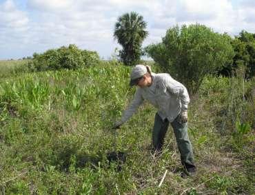
8 Holey Land levee treatment
9 FY 07/08 Treatment Rotenberger WMA Total spent = $30,000 at $104 per acre 172 acres on Powerline levee 117 acres on berms of abandoned farms Additional $8,000 spent on aerial treatment of all perimeter levees of farms for a total of 200 acres through FWC Aquatic Habitat Restoration and Enhancement Subsection (AHRES) Additional 300 acres aerially treated by SFWMD contractor


10 2008 aerial treatment Rotenberger May 5, 2008 vs. June 13, 2008
11 Planned treatment for 08/09 Everglades retreat islands and Miami Canal spoil mounds where necessary and initiate new treatment off of L-4 and L-5 levees = ~$95,000 Holey Land retreat necessary islands and continue treatment off of levees = $90,000 Rotenberger Treat all tree islands and initiate new treatment off of levees = $60,000 Treat remaining exotics in abandoned farm areas and initiate restoration project through AHRES program to push in levees and fill in canals = $500,000
12 Invasive Species Programs Native tree planting and maintenance Description Two separate contracts for planting native trees on islands cleared of Brazilian pepper and maintaining trees planted in previous years Objective Restoring islands degraded by fire, flooding, and invasion of Brazilian pepper with native trees and shrubs Start/End Dates Started by Game and Fish Commission employees as early as the 1970s with a drastic increase in planting started in early 2000s Status Ongoing, with the majority of cleared islands in WCA 3A, north of Alligator Alley and west of the Miami Canal having been planted Annual summary 1,318 trees and shrubs planted on 12 islands for a total cost of $40,000 ($3,000 per 1,000 trees) 16,984 trees and shrubs maintained on 43 islands for a total cost of $79, (includes two islands in Rotenberger) FY 08/09 = Approximately $80,000 in planting in Everglades and $130,000 in maintenance for Everglades and Rotenberger
13 Planted islands


14 Planting 2008
15 Invasive Species Programs Lygodium microphyllum survey and modeling Description Surveying 20 tree islands in WCA 3A south of I-75 in order to test a predictive model based on a number of previous Lygodium and hydrological surveys Performed by Florida Atlantic University Objective Test predictive model to determine its usefulness in predicting likely Lygodium infestations on the numerous tree islands in WCA 3A South When Lygodium is located, the locations are given to SFWMD for treatment Partners SFWMD Start/End Dates First survey performed in 2002, no end in sight Status Current survey is complete but final report is still out initial results show that more data is likely needed Annual Summary Lygodium on one out of twenty islands $158,896 for FY 07/08, approximately $150,000 budgeted for FT 08/09
16 Other Invasive Species Programs Swamp hen eradication 737 removed from WCA 2B to date, more after Thursday Analyses being performed on blood samples and stomach contents Prescribed burning Goal of 34,000 acres of prescribed burning per year in Everglades, Holey Land and Rotenberger Goals include reducing fuel loads in order to avoid catastrophic wildfires that can destroy tree islands and aid in spread of exotics Teaming up with SFWMD more often to achieve common goals and burn in areas that are usually too difficult to burn in
17 Digital Aerial Sketch Mapping Southern Glades WEA Brazilian Pepper Coverage Class Acres High 376 Medium 287 Low Total 664
18 Digital Aerial Sketch Mapping Australian Pine Coverage Class Acres High Medium 71 Low 515 Total 586
19 Digital Aerial Sketch Mapping Burma Reed Coverage Class Acres High Medium 84 Low Total 84


20 Digital Aerial Sketch Mapping Approx 2.5 ac were mechanically mulched and experimental herbicide trials for Ardesia control are underway. Scheduled activities are due to begin to treat the area around the Fish Farm to further compliment the eradication efforts on primarily Ardesia and Brazilian pepper These have been the primary SFWMD treatment activities. Also note that the primary invasive plant issue in Southern Glades seems to be Ardesia much more difficult to control than Brazilian pepper. FWC staff continue to do in-house exotics surveying and treatment in Southern Glades. In addition to Ardesia and Brazilian pepper, guava is also frequently spotted by FWC staff.

21
22 Monitoring Tracking treatment and native tree planting success in Access and ArcMap databases Tracking prescribed burns and wildfires in a ArcMap database Cattail surveys in Holey Land and Rotenberger WMAs Camera trapping on tree islands in various stages of restoration Plan to begin mapping torpedo grass expansion into areas due to ATV damage
23 Cattail monitoring in Holey Land Year Estimated % coverage


24 Questions?
Miami-Dade County s Preserves. Jane Griffin Dozier Miami-Dade County Park & Recreation Department Natural Areas Management Division
 Miami-Dade County s Preserves Jane Griffin Dozier Miami-Dade County Park & Recreation Department Natural Areas Management Division Invasive Species Programs Environmentally Endangered Lands (EEL) Program
Hillsborough County s E.L.A.P.P Program
 Hillsborough County s E.L.A.P.P Program What is E.L.A.P.P? Environmental Lands Acquisition and Protection Program History of E.L.A.P.P. - Voter-approved program initiated in 1987; extended in 1990 and
C-111 Spreader Canal Project: A Unique Example of Public Involvement and Adaptive Management in Everglades Restoration
 C-111 Spreader Canal Project: A Unique Example of Public Involvement and Adaptive Management in Everglades Restoration INTERCOL 9 June 7, 2012 Kenneth G. Ammon, P.E. Senior Vice President Overview South
IS YOUR NEIGHBOR. Landscaping to Reduce Wildfire Risk. South Florida Edition
 IS YOUR NEIGHBOR Landscaping to Reduce Wildfire Risk South Florida Edition F Wildland/Urban Interface For additional information: www.firewise.org www.floridaforestservice.com Contents 4 Fire in Florida
PHYSICAL ENVIRONMENT FUNCTION Natural Resources Department
 Director s Background James T. Evans III, M.S. PHYSICAL ENVIRONMENT FUNCTION Natural Resources Department Director Evans has been employed with the City of Sanibel for more than 14 years and has over 17
SW-71 BOYD HILL NATURE PRESERVE MITIGATION PLAN
 SW-71 BOYD HILL NATURE PRESERVE MITIGATION PLAN BACKGROUND INFORMATION Project SWIM? Aquatic Control? Exotic Control? Mitigation Bank? Type No No Yes No Mitigation Wetland and upland enhancement Type Landowner
SOUTH FLORIDA WATER MANAGEMENT DISTRICT. Question 13: Wetlands
 SOUTH FLORIDA WATER MANAGEMENT DISTRICT Question 13: Wetlands 1. The wetland responses and topographical data provided in the ADA for the 520- acre project site are conceptual in nature. The referenced
Babcock Ranch Community Invasive Species Integrated Management
 Babcock Ranch Community Invasive Species Integrated Management Creating Lower Maintenance, Costeffective Land Management Babcock Ranch Location Charlotte & Lee County 91,361-acres 73,575-acres public ownership
THE ROLE OF LILA IN EVERGLADES RESTORATION:
 THE ROLE OF LILA IN EVERGLADES RESTORATION: HARNESSING THE POWER OF A PHYSICAL MODEL Fred H. Sklar South Florida Water Management District With Eric Cline, Tom Dreschel, Rene Price, Pam Sullivan, Len Scinto,
Climate Sensitivity Runs (DRAFT)
") Climate Sensitivity Runs (DRAFT) South Florida Water Management Model SOUTH FLORIDA WATER MANAGEMENT DISTRICT February 13, 2013 Authored by: Hydrologic & Environmental Systems Modeling (HESM) Contributors:
Climate Sensitivity Runs (DRAFT) South Florida Water Management Model SOUTH FLORIDA WATER MANAGEMENT DISTRICT February 13, 2013 Authored by: Hydrologic & Environmental Systems Modeling (HESM) Contributors:
598 th Range Squadron Avon Park Air Force Range. Invasive Species Program Update
 598 th Range Squadron Avon Park Air Force Range Invasive Species Program Update Overview Military Mission at APAFR Invasive Species Program Overview Plant Animal Endangered Species Monitoring Fire Military
Moving Forward Suggestions for Reducing the Destructive Lake Discharges to the Estuaries
 Moving Forward Suggestions for Reducing the Destructive Lake Discharges to the Estuaries Gary Goforth April 2014 Moving Forward Commend Corps and District for holding Lessons Learned workshops to identify
Proposed Wetland Restoration Case Study Submittal
 Proposed Wetland Restoration Case Study Submittal 1. Project Name and Location: Little Pine Island Coastal Habitat Restoration Lee County, Florida, USA Latitude 26 37'1.39"N Longitude 82 5'23.42"W 2. Wetland
Silvicultural practices in the restoration of degraded ecosystems
 Silvicultural practices in the restoration of degraded ecosystems Current conditions reflect site history and physical environment Altered fire regimes, including exclusion Forest management, including
Linking TEK, Outreach, and Science to Protect Everglades Wetlands. Water Resources Department Marta Reczko, Water Resources Manager
 Linking TEK, Outreach, and Science to Protect Everglades Wetlands Water Resources Department Marta Reczko, Water Resources Manager Everglades Facts The Everglades is a marsh, a region, a watershed, an
Parting the Typha Sea: Using Herbicide and Fire to Restore the River of Grass. LeRoy Rodgers, SFWMD
 Parting the Typha Sea: Using Herbicide and Fire to Restore the River of Grass LeRoy Rodgers, SFWMD The Everglades Phosphorus Problem Increased phosphorus leads to cattail dominance Cattail Encroachment
Ecosystems and Biomes
 Content Vocabulary LESSON 1 Ecosystems and Biomes Directions: Use the clues and the terms listed below to complete the puzzle. NOTE: There is no empty square in the puzzle between the words of two-word
Proposed Wildlife Habitat Restoration Project At Walking Iron Wildlife Area August 6, 2015
 Proposed Wildlife Habitat Restoration Project At Walking Iron Wildlife Area August 6, 2015 Walking Iron County Wildlife Area is 898 acres situated in the Town of Mazomanie between Walking Iron County Park
Options for Reducing Harmful Lake Okeechobee Discharges and Everglades Restoration
 Options for Reducing Harmful Lake Okeechobee Discharges and Everglades Restoration The Florida Senate Appropriations Subcommittee on the Environment and Natural Resources January 11, 2017 Gary Goforth,
INVASIVE SPECIES CONTROL PLAN FOR CONSTRUCTION ACTIVITIES AND POST CONSTRUCTION MONITORING
 INVASIVE SPECIES CONTROL PLAN FOR CONSTRUCTION ACTIVITIES AND POST CONSTRUCTION MONITORING INTRODUCTION Black Oak Wind Farm, LLC is proposing to develop a wind-powered electric generating facility (the
Biscayne Bay Coastal Wetlands Phase I
 Restoration Benefits Observed from the Biscayne Bay Coastal Wetlands Project Biscayne Bay Coastal Wetlands Phase I Bahram Charkhian Lead Environmental Scientist 2017 GEER (Greater Everglades Ecosystem
Ecology & Management of Cheatgrass
 Ecology & Management of Cheatgrass Dr. Jay Norton, Soils Specialist University of Wyoming Land Reclamation Basics for Energy Development in Northeastern Wyoming February 3, 2009 Overview Exotic Exotic
719 Griswold, Suite 820 Detroit, MI DANVERS POND DAM REMOVAL AND STREAM RESTORATION PROJECT
 Great Lakes Restoration Initiative Grant Final Report US EPA Grant GL 00E006 43 October, 2013 Valley Woods Wetland Southfield Lola Valley Grow Zone Wayne County Parks Venoy Park Grow Zone Wayne County
Best Management Practices (BMPs) Regulatory Program. Ximena Pernett, P.E. Bureau of Everglades Regulation September 25, 2014
 Regulatory Program. Ximena Pernett, P.E. Bureau of Everglades Regulation September 25, 2014") Best Management Practices (BMPs) Regulatory Program Ximena Pernett, P.E. Bureau of Everglades Regulation September 25, 2014 Agenda What are best management practices (BMPs)? Why is there BMP regulatory
Best Management Practices (BMPs) Regulatory Program Ximena Pernett, P.E. Bureau of Everglades Regulation September 25, 2014 Agenda What are best management practices (BMPs)? Why is there BMP regulatory
Creating an External Agency Work Order
 WEEDDAR DATABASE Creating an External Agency Work Order When entering a work order for an external agency, select the agency from the dropdown list. Then choose a work order from the dropdown list or create
1. GENERAL DESCRIPTION OF LAND USE / COVER TYPES (SEE GENERAL DESCRIPTIONS ON PAGE 7) A 2. ADJACENT LANDS & EASEMENTS 3. FAMILY AGRICULTURAL LEGACY
 A 2. ADJACENT LANDS & EASEMENTS 3. FAMILY AGRICULTURAL LEGACY") CONSERVATION EASEMENT PROJECT: COUNTY: NAME OF LANDOWNER: CELL/OFFICE PHONE: NAME OF FARM / SITE MANAGER: CELL/OFFICE PHONE: GENERAL DESCRIPTION OF LAND USE / COVER TYPES (SEE GENERAL DESCRIPTIONS ON PAGE
CONSERVATION EASEMENT PROJECT: COUNTY: NAME OF LANDOWNER: CELL/OFFICE PHONE: NAME OF FARM / SITE MANAGER: CELL/OFFICE PHONE: GENERAL DESCRIPTION OF LAND USE / COVER TYPES (SEE GENERAL DESCRIPTIONS ON PAGE
Florida s Aquatic Plant Management Program. Jeff Schardt - Florida FWC
 Florida s Aquatic Plant Management Program Jeff Schardt - Florida FWC Scope - FL Aquatic Plant Management Program 450 public lakes and rivers - 1.25 million acres 24 exotic species - (98%) - 12 invasive
Wildlife Management Intensity Standards
 Habitat Control Practices Required Intensity Description Grazing Management The planned manipulation of livestock numbers and grazing intensities to increase food, The planned manipulation of livestock
This proposal submitted to the FHM program for FY06 would extend that collaboration to accomplish the following objectives:
 TITLE: Locate, Map, and Establish Long-Term Monitoring of Exotic-Invasive Plant Species in Forests of the Southern Appalachian Mountains Year 2 (FY06). APPLICANT: Equinox Environmental Consultation and
INVASIVE SPECIES MADE BY: RIYA, LAVANYA, ADAI, PRACHI, RUDRA
 INVASIVE SPECIES MADE BY: RIYA, LAVANYA, ADAI, PRACHI, RUDRA WHAT ARE INVASIVE SPECIES? Any Kind Of Organism that is not native to an eco system and causes harm to that particular eco system It does not
Sea Level Rise: Impacts, Adaptation and Information Gaps
 University of New Orleans ScholarWorks@UNO Coastal Resilience Workshop Coastal Resilience Workshop 2015 Oct 28th, 10:00 AM - 12:00 PM Sea Level Rise: Impacts, Adaptation and Information Gaps Jeffrey R.
Collaborative Forest Landscape Restoration Program
 Collaborative Forest Landscape Restoration Program Meg Roessing U.S.D.A. Forest Service Forest Management Staff Washington Office mroessing@fs.fed.us Background: Department and Agency Priority Our shared
SW-74 SERENOVA PRESERVE SITES 2, 3, 4, 8 MITIGATION PLAN
 SW-74 SERENOVA PRESERVE SITES 2, 3, 4, 8 MITIGATION PLAN BACKGROUND INFORMATION Project SWIM? Aquatic Control? Exotic Control? Mitigation Bank? Type No No No No Mitigation Restoration and enhancement Type
1:55-2:20 Recovering Lost Treasures: Aquatic Resource Restoration Stephen Montgomery, Allstate Resource Management
 UF/IFAS Aquatic Restoration Mini-Course 1:00-1:05 Welcome/opening remarks Lyn Gettys, University of Florida 1:05-1:30 Nursery production of emergent aquatic plants for restoration projects Gil Sharell,
Miccosukee Tribe of Indians of Florida. Rory Feeney Fish and Wildlife Director
 Miccosukee Tribe of Indians of Florida Rory Feeney Fish and Wildlife Director Brazilian Pepper Project on the Miccosukee Tribe s Cattle Pastures treated approximately 560 acres of Schinus funded through
South Bay Salt Pond Restoration Project Long-Term Restoration Planning
 South Bay Salt Pond Restoration Project Long-Term Restoration Planning State Coastal Conservancy, California Department of Fish and Game, and U.S. Fish and Wildlife Service Response to Summary of Recommendations
The National Fire Plan: Managing the Impacts of Wildfires on Communities and the Environment. An Overview and Look Ahead
 The National Fire Plan: Managing the Impacts of Wildfires on Communities and the Environment An Overview and Look Ahead April 23, 2002 Background: In September 2000, the Departments of Agriculture and
2016 Annual Volunteer Report
 2016 Annual Volunteer Report Volunteer Statistics Summary 21,954 DNR 268,817 Hours Donated 129 FTE s (Full Time Equivalents based on a 40-hour work week or 2,080 hours/year.) Volunteer hours are equivalent
Modeling Restoration Outcomes for the Everglades Ridge-Slough Landscape Jay Choi Jud Harvey Noah Schmadel
 Modeling Restoration Outcomes for the Everglades Ridge-Slough Landscape Jay Choi Jud Harvey Noah Schmadel Factors Affecting Restoration Success Hydrologic Conditions: Maintain water depth and flow for
Forest Groundcover Restoration 1
 WEC269 Forest Groundcover Restoration 1 Holly K. Ober and Jennifer L. Trusty 2 Restoration is the process of assisting the recovery of an area that has been degraded, damaged, or destroyed because of human
The State of Everglades Restoration
 FCE-LTER All Scientist Meeting The State of Everglades Restoration Fred H. Sklar 14 March 2016 Deering Estate Restoration Update Outline 1. Reservoirs, STAs & FEBs 2. Broward WPA s 3. DPM 4. MFL & Seagrass
Kim DeLaney, Ph.D. Strategic Development Coordinator. Overview & Project Approach 1/30/2014. Waterways Forum 3 - Regulation (1/29/2014) 1
 1") Waterways Forum #3: Regulation & Management of the Waterways Kim DeLaney, Ph.D. Strategic Development Coordinator Treasure Coast Regional Planning Council January 29, 2014 120+ Miles of Waterways St. Lucie
Waterways Forum #3: Regulation & Management of the Waterways Kim DeLaney, Ph.D. Strategic Development Coordinator Treasure Coast Regional Planning Council January 29, 2014 120+ Miles of Waterways St. Lucie
Science Plan. Executive Summary. Introduction
 Science Plan Executive Summary This Science Plan will establish and define the focus of the Peninsular Florida Landscape Conservation Cooperative (PFLCC) science investments. The data and products derived
Nez Perce National Forest Moose Creek Ranger District
 United States Department of Agriculture Forest Service Nez Perce National Forest Moose Creek Ranger District 831 Selway Road Kooskia, ID 83539 208 926-4258 TTY 208 926-7725 File Code: 1950 Date: Dec 30,
LIVING LANDS Helping Land Trusts Conserve Biodiversity
 LIVING LANDS Helping Land Trusts Conserve Biodiversity Habitat Restoration: Information for Land Trusts What is Habitat Restoration? Habitat restoration is defined as the process of assisting the recovery
C-111 SPREADER CANAL Western Project and Design Test
 C-111 SPREADER CANAL Western Project and Design Test Integration of Science and Engineering into Innovative Ecosystem Restoration Concepts National Conference on Ecosystem Restoration August 2011 Ray Wimbrough
Estimated Annual Cost of Invasive Plant Work in California. Federal agencies $21M
 Invasive Plants Cost California $82 Million Every Year. At least. Estimates of actual impacts reach into the $ billions. $82 million represents current costs of control, monitoring, and outreach. This
8/5/2011. Lesson Overview. Disturbance/Fragmentation. Shifting Mosaic. Number one cause of biodiversity loss. Types of disturbance. - Scale, frequency
 Lesson Overview Disturbances Fragmentation Types Measuring Corridors Effects Texas Example 1 Shifting Mosaic Landscape a shifting mosaic. - Made up of patches in different phases of successional development.
Land. Management Report SUWANNEE RIVER WATER MANAGEMENT DISTRICT
 SUWANNEE RIVER WATER MANAGEMENT DISTRICT Land 2013 Management Report Executive Summary: This document summarizes implementation of the District Land Management Plan (DLMP) on fee simple lands owned by
The Safe Harbor Program for Red-cockaded Woodpeckers in North Carolina
 U.S. Fish & Wildlife Service The Safe Harbor Program for Red-cockaded Woodpeckers in North Carolina Ralph Costa Provides assistance and benefits to private landowners The red-cockaded woodpecker is an endangered
Habitat Restoration, Longleaf Pine Forests, and the Flatwoods Salamander. Goals of Today s Talk. Habitat Restoration. Habitat Restoration
 Habitat Restoration, Longleaf Pine Forests, and the Flatwoods Salamander Kenny Wray Goals of Today s Talk Introduce you to the science of Restoration Ecology. Give you examples of the theory and processes
12 YEARS OF EVERGLADES RESTORATION
 12 YEARS OF EVERGLADES RESTORATION Idealism, Realism, War, Elections, Recession and Reform Where are We Going Now? Presented by Barbara Cintron Planning Division, Jacksonville District U.S. Army Corps
Using Airborne Imagery, GIS & Remote Sensing for Ecological Monitoring and Mapping
 Using Airborne Imagery, GIS & Remote Sensing for Ecological Monitoring and Mapping Multi-spectral Aerial Photography Geo-referenced Oblique Aerial Photography Tools and Mapping Products AES Imaging Plane
CONSERVATION 20/20 OVERVIEW. Cathy Olson, Conservation Lands Manager Lee County Department of Parks and Recreation
 CONSERVATION 20/20 OVERVIEW Cathy Olson, Conservation Lands Manager Lee County Department of Parks and Recreation What is Conservation 20/20? Lee County s current environmentally sensitive land acquisition
British Columbia. Ecosystem Restoration Program
 British Columbia Ecosystem Restoration Program Al Neal, P.Ag. RFT British Columbia Senior Ecosystem Restoration Specialist Co-Chair, BC Prescribed Fire Council Presentation focus BC Ecosystem Restoration
Floating Weed Control
 Floating Weed Control Brett W. Bultemeier & William T. Haller University of Florida, IFAS Center for Aquatic and Invasive Plants http://plants.ifas.ufl.edu The Enemies Water Hyacinth (Eichhornia crassipes)
Fire Management CONTENTS. The Benefits of Guidelines...3 Considerations...4
 Fire Management CONTENTS Fire Management 1 Introduction...3 The Benefits of Guidelines...3 Considerations...4 Planning...5 Burn Plan Development...5 Operational Activities...8 Pre-Ignition Activities...8
Narragansett Bay and Watershed Restoration Bond Fund
 Narragansett Bay and Watershed Restoration Bond Fund 1) Govt. Entities Nonpoint Source Water Pollution Control Fund 2) Non-Govt. Non-point Source Water Pollution Control Fund 3) Riparian Buffer Restoration
A Relook at CERP Interim Goals and Interim Targets GEER 2017, Coral Springs FL
 A Relook at CERP Interim Goals and Interim Targets GEER 2017, Coral Springs FL Agnes R. McLean, Everglades National Park Rebecca Elliott, Florida Department of Agriculture and Consumer Services Presentation
Biophysical Indicators of Longleaf Pine Sandhill Change. Ryan R. Jensen Department of Geography, Geology, and Anthropology
 Biophysical Indicators of Longleaf Pine Sandhill Change Ryan R. Jensen Department of Geography, Geology, and Anthropology Sandhills Species Long-leaf pine Turkey oak Wiregrass Extremely rich herbaceous
Background. AEM Tier 2 Worksheet Stream & Floodplain Management. Glossary
 AEM Tier 2 Worksheet Stream & Floodplain Management Glossary Bankfull Stage: The stage at which water starts to flow over the flood plain; the elevation of the water surface at bankfull discharge. (This
Water and Watersheds. Data Maps Action
 Water and Watersheds Data Maps Action What is the Wildlife Action Plan? Restore rare wildlife and habitats. Keep common species common. 2015 Revision: Partners in Conservation Science 2015 Revision Data
USING AQUATIC PLANT SURVEYS TO EVALUTE LAKE QUALITY
 USING AQUATIC PLANT SURVEYS TO EVALUTE LAKE QUALITY Reesa Evans, Lake Specialist Certified Lake Manager Adams County Land & Water Conservation Department P.O. Box 287 Friendship, WI 53934 Water is an important
Appendix Section 3: Grasses and Forages for Agroforestry
 Appendix Section 3: Grasses and Forages for Agroforestry In this chapter: Identifying the Proper Grasses and Forages for Agroforestry Design and Management grasses. In fact, the University of Missouri
Prescribed Grazing Plan
 FWC 17/18-77 EXHIBIT III Prescribed Grazing Plan Prepared for Babcock - Cecil Webb WMA Charlotte County, Florida In cooperation with Charlotte Soil & Water Conservation District And United States Department
Huron-Manistee National Forests Mio Ranger District 107 McKinley Road Mio, MI 48647
 United States Department of Agriculture Forest Service Huron-Manistee National Forests Mio Ranger District 107 McKinley Road Mio, MI 48647 989-826-3252 (Voice) 989-826-6073 (Fax) Dial 711 for relay service
Riparian Buffer Restoration Fund. Gregg J. Cassidy RI DEM, Sustainable Watersheds Office
 Riparian Buffer Restoration Fund Gregg J. Cassidy RI DEM, Sustainable Watersheds Office Narragansett Bay and Watershed Restoration Bond Fund 1) Govt. Entities Nonpoint Source Water Pollution Control Fund
Use of Amphibians as Indicators of Ecosystem Restoration Success 1
 CIR 1484 Use of Amphibians as Indicators of Ecosystem Restoration Success 1 Ken G. Rice, Frank J. Mazzotti, and J. Hardin Waddle 2 Introduction There are 18 native amphibians in southern Florida (Figures
Early History of Rice Creek Field Station
 Early History of Rice Creek Field Station Rice Creek Field Station 2009 Semi-aquatic terrarium made from discarded display case 1957-1959. Use for Biology 1 course. Biology 1 field lab at Fair Haven property-
STRATEGIC PLAN Introduction II. Mission Statement III. The Challenge Federal Noxious Weed Act of 1974
 VENTURA COUNTY WEED MANAGEMENT AREA (VCWMA) STRATEGIC PLAN 2010 I. Introduction The Ventura County Weed Management Area (VCWMA) is a focused group of individuals, Federal, State and County public agencies,
Florida Department of Environmental Protection
 Memorandum Florida Department of Environmental Protection To: Highlands Ranch Mitigation Bank permit application File No. 10-308703-001 From: Connie Bersok Re: May 9, 2012 status memo On May 8, Tim Rach
Prevention and Early Detection
 Prevention and Early Detection Prevention, early detection, and eradication of newly introduced invasive weed species is the most economical means of weed management. Prevention is best accomplished by
INFLOW DESIGN FLOOD CONTROL SYSTEM PLAN 40 C.F.R. PART PLANT DANIEL ASH POND B MISSISSIPPI POWER COMPANY
 INFLOW DESIGN FLOOD CONTROL SYSTEM PLAN 40 C.F.R. PART 257.82 PLANT DANIEL ASH POND B MISSISSIPPI POWER COMPANY EPA s Disposal of Coal Combustion Residuals from Electric Utilities Final Rule (40 C.F.R.
Aquatic Nuisance Species
 Aquatic Nuisance Species Exotic Species Nonindigenous species (NIS) Aquatic nuisance species (ANS) ANS Impacts Threaten the diversity or abundance of native species Threaten activities dependent on these
CHAPTER 4: CHARACTERISTICS IN ECOSYSTEMS
 1 CHAPTER 4: CHARACTERISTICS IN ECOSYSTEMS 4.3. FACTORS AFFECTING ECOSYSTEMS Pages 101-107 Nelson 1. ABIOTIC FACTORS IN TERRESTRIAL ECOSYSTEMS 2 abiotic factors are the non-living components of an ecosystem
Angeles National Forest Invasive Plant Project Station Fire Burn Area
 Tiernan Doyle California State Polytechnic Unversity, Pomona January-August 2013 Advisor: Katie VinZant Submitted September 12, 2013 Angeles National Forest Invasive Plant Project Station Fire Burn Area
LAND AND USE. Figure 2. Land cover in Rhode Island, Forest land. Nonforest land and smaller forest patches predominate in the area surrounding
 Mountain laurel Kalmia latifolia Figure 2. Land cover in Rhode Island, 1992. Forest land Developed land Agricultural land Other land Water Source: U.S. Geologic Survey, National Land Cover Data LAND AND
A Landscape Perspective on Pheasant Biology and Habitat Needs
 A Landscape Perspective on Pheasant Biology and Habitat Needs Nicole Davros, Ph.D. Wildlife Research Scientist MN DNR - Farmland Wildlife Populations & Research Group Madelia, MN Natural history Habitat
Land Management of the Santa Lucia Conservancy
 Land Management of the Santa Lucia Conservancy February 14, 2013 January 17, 2014Advisor Christopher HauserSanta Lucia ConservancySubmitted January 20, 2014 Allison Nunes CSU Monterey Bay Table of Contents
Feasibility Report with Integrated Environmental Assessment Rip Rap Landing HREP APPENDIX M MONITORING & ADAPTIVE MANAGEMENT PLAN
 Feasibility Report with Integrated Environmental Assessment APPENDIX M MONITORING & ADAPTIVE MANAGEMENT PLAN Feasibility Report with Integrated Environmental Assessment INTENTIONALLY LEFT BLANK Feasiblity
Prescribed Burning as a Habitat Management Tool
 Prescribed Burning as a Habitat Management Tool John Hughes U.S. Fish and Wildlife Service Canadian, Texas A Tough Sell in Roberts County! The 2006 wildfires created a great deal of hardship. But, range
Technical Memorandum
 An Atkins Company Technical Memorandum To: From: Mac Hatcher, PM Collier County Moris Cabezas, PBS&J Ed Cronyn, PBS&J Date: Re: Watershed Model Update Contract 08-5122, PO 4500106318 Element 4, Task 1,
Assessment of biodiverse grassland: Comments to ISCC Guidance Document Supplementing ISCC EU 202
 slide 1 of 20 Assessment of biodiverse grassland: Comments to ISCC Guidance Document Supplementing ISCC EU 202 Ecologist M. Sc. Elson Fernandes de Lima Casa da Floresta Assessoria Ambiental Ltda. 8th ISCC
Shortleaf Pine-Bluestem Restoration
 The Ouachita National Forest -1.8 million acres -west-central Arkansas -southeast Oklahoma OUACHITA NF CFLRP $350,000 in 2012 $2.4 million/year 2013-2019 Project Area is 350,000 acres Pine-Bluestem and
BLACK OTTER LAKE DISTRICT
 BLACK OTTER LAKE DISTRICT Storm water Action Plan Action Plan submitted for UW-Madison Course 272630 JDD001 #41967 Great Lakes Water Stewardship Institute 2012 Hortonville Area School District Hortonville
PRESCRIBED FIRE IN SOUTHWEST IDAHO
 2016 PRESCRIBED FIRE IN SOUTHWEST IDAHO In southwest Idaho, public land managers work to: address public health and safety concerns; treat insect and disease infestations; reduce the risk of severe wildfires
CITY OF PALM BEACH GARDENS COMPREHENSIVE PLAN CONSERVATION ELEMENT SUPPORT DOCUMENT. Prepared by: The City of Palm Beach Gardens
 CITY OF PALM BEACH GARDENS COMPREHENSIVE PLAN CONSERVATION ELEMENT SUPPORT DOCUMENT Prepared by: The July 2016 I. INTRODUCTION The continues to be committed to protect and preserve the City s natural resources
The Important Role of Landowners in Managing Unique Habitats. Darcy Kind Private Lands Biologist WDNR- Madison
 The Important Role of Landowners in Managing Unique Habitats Darcy Kind Private Lands Biologist WDNR- Madison Darcy.Kind@wisconsin.gov You are here WI Wildlife Action Plan Western Coulees and Ridges WI
WETLANDS AND WILDLIFE PONDS How to address concerns identified in your Environmental Farm Plan Worksheet #22
 INFOSHEET #22 WETLANDS AND WILDLIFE PONDS How to address concerns identified in your Environmental Farm Plan Worksheet #22 Based on Environmental Farm Plan Workbook, 4th ed. 2013 This infosheet outlines
Natural Communities of Clay Soils in the Lake Champlain Basin
 Natural Communities of Clay Soils in the Lake Champlain Basin Marc Lapin, Forest Ecologist Middlebury College Program in Environmental Studies & Champlain Valley Clayplain Forest Project What Makes Clayplain
WETLANDS AND OPEN WATERS Compensatory Mitigation Definitions of Factors
 Adverse effects as used in this section of the SOP means any adverse ecological effect on wetlands or areas of open water. Those effects, or impacts, include filling, excavating, flooding, draining, clearing,
Hydrologic and Ecologic Impacts from the CERP Indian River Lagoon South Project
 Hydrologic and Ecologic Impacts from the CERP Indian River Lagoon South Project Dr. Gretchen Ehlinger Senior Biologist US Army Corps of Engineers Jacksonville District November 15, 2016 AWRA Conference
1 ECOLOGICAL INTEGRITY
 NH METHOD FOR THE EVALUATION OF FRESHWATER WETLANDS (revised December, 2) ECOLOGICAL INTEGRITY. Are there land uses in the wetland s watershed that could degrade water quality in the wetland? a. Less than
CENTRAL AND SOUTHERN FLORIDA PROJECT COMPREHENSIVE EVERGLADES RESTORATION PLAN SITE 1 IMPOUNDMENT PROJECT FINAL SUPPLEMENTAL ENVIRONMENTAL ASSESSMENT
 CENTRAL AND SOUTHERN FLORIDA PROJECT COMPREHENSIVE EVERGLADES RESTORATION PLAN SITE 1 IMPOUNDMENT PROJECT FINAL SUPPLEMENTAL ENVIRONMENTAL ASSESSMENT June 2010 CENTRAL AND SOUTHERN FLORIDA PROJECT SITE
Design of a Spreader Swale System for Restoration of the South Florida Ecosystem
 Design of a Spreader Swale System for Restoration of the South Florida Ecosystem Hsin-Chi J. Lin 1, Stephen M. England, Hwai-Ping Cheng 1, Earl V. Edris 1, Jing-Ru C. Cheng 3, Gour-Tsyh Yeh 4, M. A. Granat
INTERMEDIATE BMI ASSESSMENT TIER 2 FIELD SHEET
 INTERMEDIATE BMI ASSESSMENT TIER 2 FIELD SHEET PHYSICAL PARAMETERS ASSESSMENT FIELD SHEET ALL TIERS NAME: DATE: TIME: STREAM OR RIVER NAME: WATERSHED NAME: TOWN: WEATHER PRESENT PAST 48 HOURS SITE DESCRIPTION
Chairman Betts requested the Coalition consider adoption of the agenda for the meeting of May 30, 2008.
 Minutes of the County Coalition for Responsible Management of Lake Okeechobee St. Lucie and Caloosahatchee Estuaries Lake Worth Lagoon Friday, May 30, 2008 Meeting Time 10:00 AM Okeechobee Civic Center,
Cheatgrass fuels rangeland fires.
 A Burning Issue: Cheatgrass fuels rangeland fires. Control the weeds that fuel wildfires with herbicide www.bettervm.basf.us.com Cheatgrass infestation increases the frequency of major rangeland wildfires
South Florida Water Management District
 Page 1 South Florida Water Management District October 17, 2007 Colonel Paul L. Grosskrugar District Commander Jacksonville District Corps of Engineers United States Army Corps of Engineers Post Office