Overview of the Walkover Assessments conducted on the Pont and Blyth catchments
|
|
|
- Cecilia Lewis
- 6 years ago
- Views:
Transcription


1 Overview of the Walkover Assessments conducted on the Pont and Blyth catchments


 Impassable")

2 Pont upstream of the Matfen Transfer (08/03/12) Pont, as supplied from the Matfen Transfer. Also an impassable barrier to fish Pont downstream of the Matfen Transfer (08/03/12) Impassable barrier at the top of the Pont Significant barrier on upper Pont


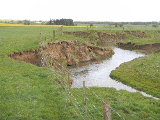
3 Significant sedimentation issues on upper Pont One of several significant barriers through Matfen Golf Course Major realignment and dredging on Blyth Major realignment and dredging on Blyth Significant erosion through livestock access on Blyth Significant erosion through livestock access on Blyth


4 Significant barrier to fish movement on Blyth Significant impoundment to river and barrier to fish movement on Blyth, as suggested by concentrated spawning effort immediately downstream Highly concentrated spawning effort and overcutting of redds on gravels immediately downstream of Hartford Weir
5 1.0 Pont and Blyth Catchment overview The walkovers of the Pont and Blyth system undertaken during this project have highlighted the wide scale impact of dredging and realignment in the catchment, the full extent of which was previously poorly understood. As the walkovers progressed, the impact of severely dredged, degraded channel morphology upon the ecological status of the catchment became increasingly evident; in most cases, degraded sections directly adjoin each other, with few areas of un-impacted, interspersed channel. The consequences of these impacts for rheophilic fish species such as trout, salmon and grayling include: a severe scarcity of spawning habitat through an absence of shallower riffles and associated clean gravel substrate; a lack of shallow margins, greatly reducing habitat value for any juvenile fish that are produced, due to narrow incised channels; an absence of flow diversity within disturbed, riffled water, greatly reducing fish shelter; Whilst major restoration of the river channels was suggested in the earlier project reports, the significant requirement of this to at least punctuate degraded sections was not fully realised until later, when more of the catchment had been observed. With this in mind, it is strongly suggested that for significant improvements to fish populations to be achieved, areas of major restoration are likely to be required. The other significant issues impacting on the system were sedimentation and barriers. It is hoped that the Northumberland Rural Diffuse Pollution Partnership will begin to tackle the sediment issues that compromise the little spawning habitat that is available. Several additional sources are also identified throughout the reports, with potential actions to be taken. Similarly, most of the barriers to fish movement (both resident and migratory) have been highlighted, and removal/improvement of passage over these, will be a further significant factor in the improvement of fish stocks on the catchment, along with the restoration of natural hydromorphological function their removal would facilitate.
6 2.0 Prescription Wherever possible, the optimal remediation for dredged, re-sectioned and realigned channels is to reinstate their natural course. This not only restores the natural channel diversity, and correct gradient for that area of the system, but also directly reconnects the watercourse with its original bed, helping to restore natural fluvial processes. The opportunity for this should be investigated fully before other options are explored, as there appeared to be significant areas of the catchment where this type of work may be feasible, particularly where large riparian buffers were already in place. Full restoration will not be possible in all sections, but reinstating sections of more natural channel planform and gradient, closely mimicking that of more natural sections, could facilitate the required natural processes. In conjunction with the major work, the in-channel habitat improvements also suggested in the reports would greatly improve habitat quality and capitalise on any gains realised through restored sections. The exact design of this prescription should be informed by a qualified geomorphologist, but some of the principles that could be used are highlighted within the reports (particularly Pont Med Burn to Small Burn). Wherever possible weirs on the catchment should also be removed, again with some input form a geomorphologist to anticipate some of the consequences of the removal. Issues highlighted through this process should not prevent the removal, as the adjustments will be part of the transition to more natural processes, but would allow for mitigation measures to be put in place. There is an ever-increasing bank of knowledge and experience within the British river restoration community that can inform the weir removal process. For example, EA N-W has removed nearly twenty structures from the River Irwell alone. Significant improvements to fish stocks on the Pont/Blyth catchment are likely to be achieved through a long-term programme of work, but the techniques highlighted within the reports provide a range of options for both shorter-term habitat enhancements and the longer-term river restoration measures.
Pont and Blyth Investigation. Small Burn - to confluence with River Pont. Dates - 16/01/12
 Pont and Blyth Investigation Small Burn - to confluence with River Pont (Waterbody ID - GB103022077050) Dates - 16/01/12 1.0 Introduction This report is the output of a site visit undertaken by Gareth
CATCHMENT RESTORATION FUND: RIVER REA RESTORATION PROJECT
 CATCHMENT RESTORATION FUND: RIVER REA RESTORATION PROJECT Project Summary The River Rea Restoration Project was a partnership project to improve watercourses in the River Rea Catchment affected by sedimentation,
These potential changes and their implications are outlined in Annex 1.
 Guidance Note Hydropower Guidance Note: This Guidance Note has been prepared by Natural Resources Wales (NRW) to provide applicants for abstraction and impoundment licences for hydropower schemes with
Water Framework Directive Investigation. Barlow Brook. Waterbody - GB
 Water Framework Directive Investigation Barlow Brook Waterbody - GB104027057700 May 2012 1 1.0 Introduction This report is the output of a site visit undertaken by Gareth Pedley of the Wild Trout Trust
CNL(10)51. NASCO Guidelines for the Protection, Restoration and Enhancement of Atlantic salmon Habitat
51. NASCO Guidelines for the Protection, Restoration and Enhancement of Atlantic salmon Habitat") CNL(10)51 NASCO Guidelines for the Protection, Restoration and Enhancement of Atlantic salmon Habitat 1. Introduction Salmon habitat in freshwater has been greatly affected by various activities, both
CNL(10)51 NASCO Guidelines for the Protection, Restoration and Enhancement of Atlantic salmon Habitat 1. Introduction Salmon habitat in freshwater has been greatly affected by various activities, both
Advisory Visit. Skitwath Beck River Eden Catchment. 9 th March 2016
 Advisory Visit Skitwath Beck River Eden Catchment 9 th March 2016 1.0 Introduction This report is the output of a site visit to Skitwath Beck and a short section of a tributary, which are themselves upper
Assessing physical habitat condition using River MImAS
 Assessing physical habitat condition using River MImAS Why? What? How? Chris Bromley Ecology Partnership & Development Unit SEPA Overview Why did we chose the MImAS approach? What is MImAS? How does it
Banking for the future. Planting trees to save rivers
 Banking for the future Planting trees to save rivers Woodland and rivers: the perfect combination Trees are proven to help restore our rivers. Woodland planting guarantees results, creates new opportunities
Delivering River Restoration: Recipes for Success 13 TH ANNUAL NETWORK CONFERENCE
 Delivering River Restoration: Recipes for Success 13 TH ANNUAL NETWORK CONFERENCE RESTORATION IN TIGHT SPACES! LEGACY ENGINEERING AND RIVER NATURALISATION G. L. Heritage, M. Schofield & S. Bentley Acknowledgments
Drought Permit modify existing abstraction
 Drought Permit modify existing abstraction Section 79A Water Resources Act 1991 as amended by the Environment Act 1995 The Environment Agency ( the Agency ) grants this drought permit to: United Utilities
Oxon Ray Catchment Summary of significant issues affecting the water environment
 Oxon Ray Catchment Summary of significant issues affecting the water environment Introduction This information pack has been produced to support the Challenges and Choices consultation document for the
Improving the physical condition of Scotland s water environment. A supplementary plan for the river basin management plans
 Improving the physical condition of Scotland s water environment A supplementary plan for the river basin management plans Contents Executive summary... 2 1. Introduction... 3 2. Vision... 4 3. Taking
Table D1: WC-R1 to WC-R3 (Wilket Creek Park)
") APPENDIX D Table D1: WC-R1 to WC-R3 (Wilket Creek Park) Category of Consideration Criteria Alternative 1 Do Nothing Alternative 2 Local Improvements Alternative 3 Channel Realignment Natural Geomorphic
APPENDIX D Table D1: WC-R1 to WC-R3 (Wilket Creek Park) Category of Consideration Criteria Alternative 1 Do Nothing Alternative 2 Local Improvements Alternative 3 Channel Realignment Natural Geomorphic
Kachess River Action #1: Upper Kachess River Habitat and Passage Projects
 Kachess River Action #1: Upper Kachess River Habitat and Passage Projects Action Type: Research / Recovery Life stage(s) affected: Juvenile rearing, pre/post spawning migrations Threat addressed: Altered
Don Catchment Vision
 Don Catchment Vision Don Catchment Vision A healthy and biodiverse catchment that is valued and enjoyed, contributing to the economic and social well-being of local communities. Aims for the Don To identify
Advisory Visit for the North Yorkshire Moors National Park and Glaisdale Angling Club. River Esk, North Yorkshire
 Advisory Visit for the North Yorkshire Moors National Park and Glaisdale Angling Club River Esk, North Yorkshire 13 th June 2013 1.0 Introduction This report is the output of a site visit undertaken by
Scottish Environment Protection Agency
 Scottish Environment Protection Agency Susan MacPherson Senior Environment Protection Officer Stornoway Office The Water Environment (Controlled Activities) (Scotland) Regs 2011 Certain activities in surface
Rascal Goose. Reach 1. Rascal Goose. Reach 2. å å å. Main Goose Pit. Stream Reach 3. Main Goose Pit. Stream Reach 7
 434000 March 16 2014 434200 434400 ± 434600 434800 435000 Goose Lake 7269800 WRSA B 7269800 7270000 433800 GIS # BAC-06-180a 7270000 PROJECT # 0234411-0005 Rascal Goose Reach 1 Main Goose Pit Stream Reach
Funded by the Irish Government under the National Development Plan Document Number: DC093
 Funded by the Irish Government under the National Development Plan 2000-2006 Shannon Internatiional Riiver Basiin Diistriict Project Freshwater Morphology POMS Study Work Package 2 Programme of Measures
Proposed Norwegian classification limits according to morphological modification of surface water bodies
 Proposed Norwegian classification limits according to morphological modification of surface water bodies Brian Glover MULTICONSULT AS brg@multiconsult.no with Trygve Hesthagen (NINA) and Eva Skarbøvik
AVISORY VISIT TO THE GRANTHAM ANGLING ASSOCIATION FISHERY AT BELTON HOUSE, RIVER WITHAM, LINCOLNSHIRE UNDERTAKEN BY VAUGHAN LEWIS, WINDRUSH AEC.
 . AVISORY VISIT TO THE GRANTHAM ANGLING ASSOCIATION FISHERY AT BELTON HOUSE, RIVER WITHAM, LINCOLNSHIRE UNDERTAKEN BY VAUGHAN LEWIS, WINDRUSH AEC. SEPTEMBER 2005 1.0 Introduction This report forms the
Site Improvement Plan. River Kent SAC. Improvement Programme for England's Natura 2000 Sites (IPENS) Planning for the Future
 Planning for the Future") Improvement Programme for England's Natura 2000 Sites (IPENS) Planning for the Future Site Improvement Plan River Kent Site Improvement Plans (SIPs) have been developed for each Natura 2000 site in England
Improvement Programme for England's Natura 2000 Sites (IPENS) Planning for the Future Site Improvement Plan River Kent Site Improvement Plans (SIPs) have been developed for each Natura 2000 site in England
Working together To improve our water environment Glazert Water
 Working together To improve our water environment Glazert Water Potential options for river restoration and natural flood management in the Glazert catchment Draft summary report 1.0 Introduction 1 Report
Ecology and River Restoration
 Ecology and River Restoration Ecology is the study of the relationships between plants and animals and the environment in which they live. Owen, 1980 Martin Janes Managing Director The River Restoration
Ongoing and Completed Studies
 Attachment 2 Ongoing and Completed Studies 2014 Monitoring and Analysis Plan November 2013 Attachment 2 Ongoing and Completed Studies 1 Introduction In 2013, the small interdisciplinary study groups for
Improving the River Petteril Online Story Map featuring a case study in catchment management
 Improving the River Petteril Online Story Map featuring a case study in catchment management Summary The Improving the River Petteril story map presents a catchment management case study for the River
GB River Esk from source to Baysdale Beck (Esk and Coast) Ecological Status: Moderate. Failing Elements: Fish, ph, Zinc
 Ecological Status: Moderate. Failing Elements: Fish, ph, Zinc") GB104027068090 River Esk from source to Baysdale Beck (Esk and Coast) Ecological Status: Moderate Failing Elements: Fish, ph, Zinc Costings Issues identified Solutions / work required Responsibility/Lead
GB104027068090 River Esk from source to Baysdale Beck (Esk and Coast) Ecological Status: Moderate Failing Elements: Fish, ph, Zinc Costings Issues identified Solutions / work required Responsibility/Lead
Public Information Centre September 19 th, 2017
 Public Information Centre September 19 th, 2017 WELCOME! Public Information Centre for the Maple Hill Creek Rehabilitation Class Environmental Assessment Please take the time to sign our sign in sheet
Dr. Paul Villard Toronto and Region International Erosion Control Association March 27, 2012
 Dr. Paul Villard Toronto and Region International Erosion Control Association March 27, 2012 GEOMORPHOLOGICAL CHARACTERIZATION CREEK AND SHORELINE RESTORATION l FLUVIAL AND COASTAL HAZARD ASSESSMENT HYDRAULIC
River Forth catchment profile
 River Forth catchment profile Introduction The River Forth catchment encompasses a large area approximately 1029 km 2. As can be seen in Figure 1, the catchment not only contains the River Forth itself,
COTTON CREEK CULVERT REPLACMENT
 COTTON CREEK CULVERT REPLACMENT Integrating Mobility with Environmental Innovation Located along a scenic section of Highway 3/95 in British Columbia, Moyie Bluffs, a 6.5 km stretch of inland highway had
Advisory Visit. Bog Burn (Bathgate Water) River Forth Catchment. Stirlingshire
 River Forth Catchment. Stirlingshire") Advisory Visit Bog Burn (Bathgate Water) River Forth Catchment Stirlingshire Undertaken by Gareth Pedley Key findings Major straightening and realignment have greatly reduced the habitat quality of the
Advisory Visit Bog Burn (Bathgate Water) River Forth Catchment Stirlingshire Undertaken by Gareth Pedley Key findings Major straightening and realignment have greatly reduced the habitat quality of the
Ecological effects of re-meandering lowland streams and use of restoration in river basin management plans: Experiences from Danish case studies
 Ecological effects of re-meandering lowland streams and use of restoration in river basin management plans: Experiences from Danish case studies, National Environmental Research Institute (NERI), University
Stevens Creek Steelhead Limiting Factors Analysis. Stillwater Sciences
 Stevens Creek Steelhead Limiting Factors Analysis Stillwater Sciences May 18, 2004 Project Goals! Identify and fill information gaps related to physical and biological factors controlling population dynamics
Natural flood management guidance:
 Practical Guidence Natural flood management guidance: Woody dams, deflectors and diverters July 2016 Natural flood management guidance: Woody dams, deflectors and diverters July 2016 1 Introduction Large
Upper Wharfe Sub-Catchment Evidence Pack for the Water Framework Directive
 Upper Wharfe Sub-Catchment Evidence Pack for the Water Framework Directive Executive summary of suggested EA priorities: Need Characterisation Study of Hebden Beck; this advanced study will identify the
Beds of Water Bodies 14 September 2017
 Beds of Water Bodies 14 September 2017 Contents Beds of Water Bodies... 1 Activities in the Beds of Water Bodies Issues... 1 Objectives... 4 Policies... 4 Methods of Implementation... 7 Rules... 11 Stock
Water of Leith catchment profile
 catchment profile Introduction The catchment covers a total area of 122 km 2 and predominantly drains the north western slopes of the Pentland Hills from its source in the Colzium springs. The natural
WHY ARE STREAM IMPROVEMENTS NEEDED IN TENNESSEE? TENNESSEE STREAMS
 WHY ARE STREAM IMPROVEMENTS NEEDED IN TENNESSEE? TENNESSEE STREAMS Most diverse aquatic fauna in the country Majority of West TN streams are channelized 36,000 miles of degraded stream are in need of restoration
7.0 WATER-BASED CONTROL MEASURES
 7.0 WATER-BASED CONTROL MEASURES 7.1 IDENTIFICATION AND DESCRIPTION OF CONTROL MEASURES Table 7-1 lists the water-based options being considered for implementation in the initial screening stage. Descriptions
Eye Water and Berwick coastal catchment profiles
 Eye Water and Berwick coastal catchment profiles These catchment profiles have been produced together because the Eye Water priority catchment work includes water bodies within both catchments, the land
Appendix 6 Weir Assessments
 Appendix 6 Weir Assessments Second edition, September 2013 1. Introduction This section of work assesses the connectivity of the River Teme with respect to fish passage. A number of barriers have been
Environmental Management Plan for Restoring Fish Passage to the Stream Crossing At 12.8 km on the Chuchinka - Crocker FSR
 Environmental Management Plan for Restoring Fish Passage to the Stream Crossing At 12.8 km on the Chuchinka - Crocker FSR Prepared for: Canadian Forest Products Ltd. Prince George Woodlands Division 5162
River Carron catchment profile
 River Carron catchment profile Introduction From its source in the Campsie Fells, the River Carron drains an area of approximately 192 km 2 before entering the Firth of Forth via the Carron Estuary at
Ten Principles of River Restoration and Four River Project of Korea
 Ten Principles of River Restoration and Four River Project of Korea Randolph T. Hester, G. Mathias Kondolf, Marcia McNally, Department of Landscape Architecture and Environmental Planning University of
Warwickshire Avon Catchment Partnership
 Warwickshire Avon Catchment Partnership Working in Partnership Gina Rowe Living Landscapes Manager Tim Precious Wetland Project Officer Warwickshire Wildlife Trust Creating a Living Landscape www.warwickshirewildlifetrust.org.uk
Enhancing Straightened River Channels
 .6 Creating a sinuous low flow channel in an over-widened river River Dearne Location - Mexborough, West of Doncaster, South Yorkshire SE484012 Date of construction - Summer 1995 Length - 500m Cost - 4,000
Conceptual Design and Feasibility of a Natural Fishway at the Fremont BART Weir, Alameda Creek, California
 Conceptual Design and Feasibility of a Natural Fishway at the Fremont BART Weir, Alameda Creek, California Final Report September 2005 Prepared by Center for Ecosystem Management and Restoration, Oakland,
River restoration in Europe - General principles and approaches, restoration measures, effects on river biota
 Jochem Kail University of Duisburg-Essen River restoration in Europe - General principles and approaches, restoration measures, effects on river biota General principles and approaches Holistic vs. sectoral
Guidance for developers of run-of-river hydropower schemes
 Guidance for developers of run-of-river hydropower schemes Version 2.3 November 2015 INTRODUCTION... 2 BACKGROUND... 3 PART A: SCREENING PROCESS... 4 OVERVIEW OF APPROACH WHERE ANNUAL OUTPUT
Fish Habitat Design, Operation and Reclamation Workbook and Worksheets for Placer Mining in the Yukon Territory
 Fish Habitat Design, Operation and Reclamation Workbook and Worksheets for Placer Mining in the Yukon Territory Version 1.0 April 2008 This document is available from the Yukon Placer Secretariat, Yukon
Fish Passage Culvert Inspection (FPCI)
") Fish Passage Culvert Inspection (FPCI) Creighton Creek (CR) Watershed FIA Project Number SOTSA 9153004 Prepared for: Tolko Industries Ltd., Okanagan Regional Woodlands Prepared by: Michele Trumbley, RPBio
Fish Passage Culvert Inspection (FPCI) Creighton Creek (CR) Watershed FIA Project Number SOTSA 9153004 Prepared for: Tolko Industries Ltd., Okanagan Regional Woodlands Prepared by: Michele Trumbley, RPBio
Case study 6. Chelmer Valley Local Nature Reserve
 Case study 6. Chelmer Valley Local Nature Reserve Author: Trevor Bond Main driver: Habitat improvement Project stage: Completed spring 2016 Photo 1: River Chelmer, Chelmer Valley Local Nature Reserve (source:
Fish Habitat Design, Operation and Reclamation Workbook and Worksheets for Placer Mining in the Yukon Territory
 Fish Habitat Design, Operation and Reclamation Workbook and Worksheets for Placer Mining in the Yukon Territory Version 1.3 November 2010 This document is available from: Yukon Placer Secretariat, 206B
Advisory Visit undertaken by Gareth Pedley on behalf of the Wild Trout Trust for Sowerby Angling Society. Cod Beck
 Advisory Visit undertaken by Gareth Pedley on behalf of the Wild Trout Trust for Sowerby Angling Society Cod Beck April 25 th 2013 1.0 Introduction This report is the output of a site visit undertaken
Carp Creek 2013 Summary Report
 Monitoring Activity in the Carp River Watershed In 2012, Mississippi Valley Conservation Authority (MVCA) worked with Friends of the Carp River (FCR) on a preliminary assessment of the Carp River. This
Temporary Watercourse Crossing: Fords
 Temporary Watercourse Crossing: Fords DRAINAGE CONTROL TECHNIQUE Low Gradient Velocity Control Short Term Steep Gradient Channel Lining Medium-Long Term Outlet Control Soil Treatment Permanent [1] [1]
Public Notice. Public Notice No. Date: April 8, 2016 CENAP-PL-E Comment Period Closes: May 9, 2016
 Public Notice Public Notice No. Date: April 8, 2016 CENAP-PL-E-16-02 Comment Period Closes: May 9, 2016 USACE Philadelphia District: http://www.nap.usace.army.mil COBBS CREEK FISH PASSAGE PROJECT SECTION
The River Brent. An advisory visit carried out by the Wild Trout Trust March The River Brent at Tokyngton Park, Wembley
 The River Brent An advisory visit carried out by the Wild Trout Trust March 2012 The River Brent at Tokyngton Park, Wembley 1 1. Introduction This report is the output of a Wild Trout Trust advisory visit
MUCKLESHOOT INDIAN TRIBE Fisheries Division nd Avenue SE Auburn, Washington
 MUCKLESHOOT INDIAN TRIBE Fisheries Division 39015-172 nd Avenue SE Auburn, Washington 98092-9763 Phone: (253) 939-3311 Fax: (253) 931-0752 Scott Sissons Pierce County Planning and Land Services 2401 South
Background for: Upper Piddle Headwaters
 Background for: Upper Piddle Headwaters Environment Agency Information Waterbody Upper Piddle Waterbody ID GB108044010120 Status Poor Failing elements Fish macrophytes (flows) Phytobenthos (nutrients)
The Streamkeepers Handbook
 The Streamkeepers Handbook A Practical Guide To Stream And Wetland Care Appendix 1 COMMON HABITAT RESTORATION TECHNIQUES Check Table 3 for the references that provide detailed instructions for these projects.
Yakima Tributary Access & Habitat Program Summary of Accomplishments Diversion 14 Fish Passage and Screening, 2003 Ahtanum Creek
 Yakima Tributary Access & Habitat Program Summary of Accomplishments Diversion 14 Fish Passage and Screening, 2003 Ahtanum Creek This early action project involved removing a fish passage barrier, screening
Central Strait Drainages DRAINAGES AST WRIA 19 AST
 Page 41 CENTRAL STRAIT DRAINAGES AST WRIA 19 EAST AST Deep Creek East Twin River E. Fork East Twin & Sadie Creek West Twin River Lake Crescent / Lyre River System Murdock Creek Field, Whiskey & Colville
Assessing the effect of a catchment-scale restoration project in Wallonia (Belgium) Peeters A et al.
 Peeters A et al.") Assessing the effect of a catchment-scale restoration project in Wallonia (Belgium) Peeters A et al. ALEXANDRE PEETERS Hydrology and Fluvial Geomorphology Research Centre, University of Liège, Allée du
Assessing the effect of a catchment-scale restoration project in Wallonia (Belgium) Peeters A et al. ALEXANDRE PEETERS Hydrology and Fluvial Geomorphology Research Centre, University of Liège, Allée du
IMPROVING OUTCOMES FOR STREAM ALTERATION PROJECTS
 IMPROVING OUTCOMES FOR STREAM ALTERATION PROJECTS Bethany Matousek Inland Lakes and Streams Program Coordinator Wetlands, Lakes and Streams Unit DEQ Water Resources Division MatousekB@Michigan.gov 517-243-6421
Road-Stream Crossing Assessments in the Upper White River Watershed
 FINAL PROJECT REPORT Road-Stream Crossing Assessments in the Upper White River Watershed by the White River Watershed Partnership, Grantee Dr. Thomas Tisue, P.I. in collaboration with Muskegon Community
Introduction to stream assessment
 Why do stream assessment? Introduction to stream assessment Given the current condition of rivers and the heightened public interest in them, there is a significant need for the ability to determine the
Case study 11. Low Stanger Floodplain Reconnection Project
 Case study 11. Low Stanger Floodplain Reconnection Project Author: Ian Creighton Main driver: Flood alleviation Project stage: Completed 2015 Photo 1: Downstream breach, Low Stranger Farm (source: West
Assessing Fish Passage at Culverts the method, its metrics and preliminary findings from over 4,000 assessments.
 Assessing Fish Passage at Culverts the method, its metrics and preliminary findings from over 4,000 assessments. Richard Thompson, Ministry of Environment, Richard.Thompson@gov.bc.ca ABSTRACT There has
Site Improvement Plan. River Axe SAC. Improvement Programme for England's Natura 2000 Sites (IPENS) Planning for the Future
 Planning for the Future") Improvement for England's Natura 2000 Sites (IPENS) Planning for the Future Site Improvement Plan River Axe Site Improvement Plans (SIPs) have been developed for each Natura 2000 site in England as part
Improvement for England's Natura 2000 Sites (IPENS) Planning for the Future Site Improvement Plan River Axe Site Improvement Plans (SIPs) have been developed for each Natura 2000 site in England as part
GRAYS HARBOR ESTUARY MANAGEMENT UNIT GRAYS HARBOR ESTUARY
 GRAYS HARBOR ESTUARY MANAGEMENT UNIT GRAYS HARBOR ESTUARY Description: The Grays Harbor Estuary is a bar-built estuary that was formed by the combined processes of sedimentation and erosion caused by both
Fish Habitat Design, Operation and Reclamation Workbook and Worksheets for Placer Mining in the Yukon Territory
 Fish Habitat Design, Operation and Reclamation Workbook and Worksheets for Placer Mining in the Yukon Territory Fish Habitat Design, Operation and Reclamation Workbook and Worksheets for Placer Mining
PROJECT SCREENING MATRIX: A User s Guide
 Version 2.0 Page 1 of 7 November 9, 2010 PROJECT SCREENING MATRIX: A User s Guide BACKGROUND The Project Screening Matrix (Screening Matrix) is one of several tools that comprise the River Restoration
Advisory Visit for the East Yorkshire Chalk Rivers Trust. River Derwent (Yorkshire)
") Advisory Visit for the East Yorkshire Chalk Rivers Trust River Derwent (Yorkshire) Date 13/09/2012 1.0 Introduction This report is the output of a site visit undertaken by Gareth Pedley of the Wild Trout
Advisory Visit for the East Yorkshire Chalk Rivers Trust River Derwent (Yorkshire) Date 13/09/2012 1.0 Introduction This report is the output of a site visit undertaken by Gareth Pedley of the Wild Trout
NCS Design Approach. Biology/Ecology Primer. Presented by: Jack Imhof, National Biologist Trout Unlimited Canada
 NCS Design Approach Biology/Ecology Primer Presented by: Jack Imhof, National Biologist Trout Unlimited Canada Biology/Ecology Key biological principles that are applied Need to speak the same language
Projects must fall under one of the nine categories listed in Table 1.
 UNITED STATES DEPARTMENT OF COMMERCE National Oceanic and Atmospheric Administration NATIONAL MARINE FISHERIES SERVICE West Coast Region Snake Basin Office 800 Park Boulevard, Plaza IV, Suite 220 Boise,
Humber Management Scheme. FAQs Water quality
 Humber Management Scheme FAQs Water quality Key organisations and involvement in EMS management The Water Framework Directive (WFD) sets out how the water environment in England will be managed using a
De-culverting of watercourses
 Policy Position Statement De-culverting of watercourses Purpose This Policy Position Statement sets out the position of the Chartered Institution of Water and Environmental Management (CIWEM) on de-culverting
Improving the condition of Solway Tweed s water environment Tweed area management plan
 Improving the condition of Solway Tweed s water environment Tweed area management plan 2010 2015 Supplementary to the river basin management plan for the Solway Tweed river basin district Page 1 of 20
Habitats Regulation Compensation Package
 Itchen Drought Order Habitats Regulation Compensation Package Draft 20 March 2018 This document has been prepared following consultation with the Environment Agency, Natural England and the Hampshire &
Application for Paragraph 35(2)(b) Fisheries Act Authorization for Workforce Accommodation Centre Revision 1, November 2015
(b) Fisheries Act Authorization for Workforce Accommodation Centre Revision 1, November 2015") Application for Paragraph 35(2)(b) Fisheries Act Authorization for Workforce Accommodation Centre The copyright of this document is vested in LNG Canada Development Inc. All rights reserved. 8. FISH HABITAT
Application for Paragraph 35(2)(b) Fisheries Act Authorization for Workforce Accommodation Centre The copyright of this document is vested in LNG Canada Development Inc. All rights reserved. 8. FISH HABITAT
Afon Machno: WFD waterbody GB Machno
 Afon Machno: WFD waterbody GB110066054810Machno Existing/historical information Previous reports of thriving trout populations indicate that the potential should exist for good contemporary populations.
Case Studies III: Skokomish River Ecosystem Restoration Washington State
 University of Massachusetts - Amherst ScholarWorks@UMass Amherst International Conference on Engineering and Ecohydrology for Fish Passage International Conference on Engineering and Ecohydrology for Fish
Use of WARSSS in Stream Restoration and Watershed Planning. Michigan Aquatic Restoration Conference 2015
 Use of WARSSS in Stream Restoration and Watershed Planning Michigan Aquatic Restoration Conference 2015 October 22, 2015 Use of WARSSS in Stream Restoration and Watershed Planning 1. Watershed Management
Impact of the Controlled Activities Regulations on Dam Construction, Maintenance and Operation in Scotland
 Impact of the Controlled Activities Regulations on Dam Construction, Maintenance and Operation in Scotland C. W. BERRY, GHD Pty, Australia (formerly of W A Fairhurst and Partners) K. M. H. BARR, W. A.
Construction of Artificial Riffles and Pools For Freshwater Habitat Restoration
 Construction of Artificial Riffles and Pools For Freshwater Habitat Restoration Kate Howe Preserving biodiversity is one of the central goals of ecologists and conservation biologists today. As human population
CLOCA Rural & Agricultural Guide to Permits
 CLOCA Rural & Agricultural Guide to Permits Regulation of Development, Interference with Wetlands and Alterations to Shoreline and Watercourses, Ontario Regulation 42/06 April 2014 Table of contents Introduction...
Treatment Strategies based on Stream Stratification Methodology by W. Barry Southerland Fluvial Geomorphologist, WNTSC, USDA, NRCS
 Treatment Strategies based on Stream Stratification Methodology by W. Barry Southerland Fluvial Geomorphologist, WNTSC, USDA, NRCS Cedar Creek, WA - 2005 Cedar Creek, WA - 2005 Asotin Creek, WA 2005: photo
River restoration and flood management fact or fiction: a British perspective
 River restoration and flood management fact or fiction: a British perspective Dr Jenny Mant Head of Water Management Jenny.Mant@ricardo.com jenny.mant@ricardo.com 6/2/2017 A Retrospective Look 2007 UK
Riparian Buffers and Stream Restoration
 Riparian Buffers and Stream Restoration Why focus on riparian areas? Link land and water on any given site and link landscapes together in a watershed Riparian corridors protect the circulatory system
Fish passage at water intake infrastructure
 Fish passage at water intake infrastructure Fish Passage Restoration Symposium, 27 th November 2013 Sjaan Bowie Freshwater Team, Science & Capability, DOC sjaanbowie@doc.govt.nz What is a water intake?
River Restoration in Denmark
 River Restoration in Denmark 30 years of experience and what have we achieved? Morten Lauge Pedersen, Aalborg University Nikolai Friberg, NERI, Aarhus University Outline Background River restoration in
Tidal Thames Catchment-based Pilot Project
 Tidal Catchment-based Pilot Project Context The catchment of the Tidal flows from Teddington, in the west, to the estuary near Southend-on-Sea, in the east. The water surface area for this length of the
Water Framework Directive and EIA: our experience. Jo Murphy, MIEMA CEnv MCIM National Environmental Assessment Service (NEAS) 31 May 2012
 31 May 2012") Water Framework Directive and EIA: our experience Jo Murphy, MIEMA CEnv MCIM National Environmental Assessment Service (NEAS) 31 May 2012 The plan Me: Aims & objectives of the Water Framework Directive
Water Framework Directive and EIA: our experience Jo Murphy, MIEMA CEnv MCIM National Environmental Assessment Service (NEAS) 31 May 2012 The plan Me: Aims & objectives of the Water Framework Directive
BMA Broadmeadow Mine - EHP EA amendment application (Pre-lodgement meeting) Wednesday 22 April, 2015
 Wednesday 22 April, 2015") BMA Broadmeadow Mine - EHP EA amendment application (Pre-lodgement meeting) Wednesday 22 April, 2015 Broadmeadow Mine 2 BRM Subsidence Management Plan SMP Purpose SMP is the document that outlines the
BMA Broadmeadow Mine - EHP EA amendment application (Pre-lodgement meeting) Wednesday 22 April, 2015 Broadmeadow Mine 2 BRM Subsidence Management Plan SMP Purpose SMP is the document that outlines the
May 15, Lower Squaw Creek Restoration Public Workshop. for The Friends of Squaw Creek Truckee River Watershed Council Sierra Nevada Conservancy
 Lower Squaw Creek Restoration Public Workshop for The Friends of Squaw Creek Truckee River Watershed Council Sierra Nevada Conservancy Prepared by: Mike Liquori May 15, 2008 Funding for this project has
8. A. AQUATIC HABITATS
 ENCLOSURE C S.R. 1006 SECTION 80S DELAWARE CANAL BRIDGE REHABILITATION PROJECT, TINICUM TOWNSHIP, BUCKS COUNTY, PENNSYLVANIA DESCRIPTION OF AQUATIC HABITAT 8. A. AQUATIC HABITATS (1) Food Chain Production-
Prepared by Christchurch City Council, P.O. Box 73013, Christchurch. Submission by Avon-Ōtākaro Network, 9 Stable Way, Christchurch 8051
 Christchurch City Council Christchurch October 2013 Submission to the Draft South New Brighton Reserves Management Plan, 2013 Draft South New Brighton Reserves Development Plan, 2013 For Bligh s Garden,
Fish Passage Planning and Design
 Fish Passage Planning and Design Culvert Fishway Planning and Design Guidelines Part A About These Guidelines Ross Kapitzke James Cook University School of Engineering and Physical Sciences April 2010