Operational Range Assessment Program (ORAP) Phase II Overview. Andrea Graham USACE, Baltimore District
|
|
|
- Albert Holt
- 6 years ago
- Views:
Transcription
1 Operational Range Assessment Program (ORAP) Phase II Overview Andrea Graham USACE, Baltimore District
2 Operational Range Assessment Program Background Mission Establish information excellence to support the Army s Range Sustainment Program. Intent Keep ranges open and available for testing and training. Ensure people on and off Army installations are not drinking water contaminated by explosives. Address regulatory and public concerns.

3 ORAP Assessments use a phased approach and are based on Source Receptor Interactions
4 Phase II Quantitative Assessment U.S. Army Public Health Command (Provisional) Phase II Approach Develop installation-specific HSP and APPs Develop DQOs Develop QAPPs using UFP-QAPP Identify and address applicable SW and GW pathways only Develop detailed Viable Pathway CSMs (discussion and illustration) - Incorporate non-range influences and degradation - Select effective sample locations GW sampling at/near sources (not on impact areas) or exposure points SW sampling - Account for temporal variability (wet/dry seasons, high/low flow events) - Use SW decision flow chart
5 Phase II Quantitative Assessment USAPHC (Provisional) Phase II Approach (continued) Ecological Risk Assessments aquatic receptors only - Background and 95% UCL of mean results vs. screening levels comparison - Benthic macroinvertebrate surveys false Positive / Negative Human Health Risk Evaluations - Initial data screening direct comparison to screening levels - Quantitative data screening determine need for HHRA Referred categorization must be based on Risk Assessment results not just on Phase II data
6 Phase II ORAP ACSIM has overall Army responsibility for Operational Range Assessment Program including funding and guidance. G3 provides HQDA level operator input. AEC and NGB are the Program Managers for Phase II Assessments. USAPHC (Provisional) will provide technical oversight and QA. Contract mechanism for Phase II Assessments will consist of AE IDQ, Multiple Award Military Munitions, and Multiple Award Environmental Service contracts. Total number of Active and Reserve installations requiring a Phase II is 45 including the seven (7) pilot studies. Phase II completion date is 2014.

7 ORAP Phase II Pilot USAG Fort Jackson / McCrady Training Center Rhonda Stone Malcolm Pirnie, Inc. rstone@pirnie.com 2010 Malcolm Pirnie, Inc. All Rights Reserved
 Used")


8 Installation Overview / Fast Facts Fort Jackson - Army owned/operated 36,971 acres (+15,267 acres operated by SCARNG) Used 1917 to present for Basic & Advanced Infantry Training 29,475 operational acres / 16,471 categorized as Inconclusive* 104 operational ranges / 51 categorized as Inconclusive McCrady Training Center - Army owned/ngb operated 15,267 acres in total Used by SCARNG since ,895 operational acres / 12,243 categorized as Inconclusive* 62 operational ranges / 48 categorized as Inconclusive* * Inconclusive Existing information is either insufficient to make a source-receptor interaction determination or indicates a potential for such interaction to be occurring.


9 Surface Water System Study Overview Watersheds Gills Creek Colonels Creek Cedar Creek Mill Creek * Sampling Events Wet Season A + B April Storm - May Dry Season A + B - July Surface Water Analysis Explosives by EPA 8095M Dissolved Metals by EPA 1638M Perchlorate by EPA 6850 Sediment Analysis Explosives by EPA 8330A Metals by 6020A Benthic Macroinvertebrates Explosives by EPA 8330A Metals by 6020A
10 Surface Water System Study Results Colonels Creek Surface Water MCOC Antimony, lead, and zinc exceeded reference None exceeded PAL at 95% UCL of mean Sediment MCOC Copper, lead, and zinc exceeded reference None exceeded PAL at 95% UCL of mean Benthic Macroinvertebrates No indications of impairments Surface Water and Sediment MCOC MCOC Exceeding Reference MCOC Exceeding Project Action Levels at 95% UCL of the mean Antimony Surface Water Surface Water Copper Antimony None Lead Lead Tungsten Zinc Sediment Zinc None 1,3,5-Trinitrobenzene 1,3-Dinitrobenzene 2,4,6-Trinitrotoluene 2,4-Dinitrotoluene 2,6-Dinitrotoluene 2-Amino-4,6-Dinitrotoluene 3,4-Dinitrotoluene (SW Only) 4-Amino-2,6-Dinitrotoluene 4-Nitroaniline (SD Only) HMX m-nitrotoluene Nitrobenzene Nitroglycerine o-nitrotoluene Perchlorate (SW Only) p-nitrotoluene RDX Tetryl Sediment Copper Lead Zinc

11 Surface Water System Study Findings Colonels Creek Conceptual Site Model
")


12 Groundwater System Study Overview Worst-Case Groundwater Investigation Area (Blue Outline) Worst-Case based on munitions type and loading, & proximity to receptors 2 Stages Stage I (30 March 20 May 2009): - 7 Piezometers - 5 staff gauge / piezometer pairs - Groundwater elevation measurement Piezometer Locations

 plus sodium by EPA E200.7 - Anions (sulfate, chloride, and nitrate) by EPA 300.")
13 Groundwater System Study Overview Stage II (27 May 10 June 2009) 5 Soil Borings and 1 Deep Monitoring Well 26 depth-discrete groundwater samples 20-foot intervals to approximately 150 feet AMSL One existing supply well sampled Analyses MCOC - Explosives by EPA 8095M - Perchlorate by EPA Total and dissolved metals (antimony, copper, lead, zinc, and tungsten) by EPA Water Quality - Hardness metals (calcium and magnesium) plus sodium by EPA E Anions (sulfate, chloride, and nitrate) by EPA Alkalinity by EPA 310.1/SM2320B - Total dissolved solids (TDS) by SM2450C Soil Boring Locations

14 Geology Groundwater System Results Predominantly sand (fine- to medium-grained, sub-angular quartz, micaceaous zones) Frequent clay units, laterally discontinuous upper, potentially continuous lower clay unit present in all 5 soil borings Shallow Groundwater Flow Topography controlled flow Radial flow west, south, and east from investigation area Discharge of shallow groundwater to low order streams (Cedar Creek, Colonels Creek, Jumping Run Creek)

15 Groundwater System Results Areal Extent of Perchlorate and RDX Detections Groundwater Investigation Area ClO 4 A ClO 4 Cross-Section Locations B RDX Down-Gradient Receptors ClO 4 ClO 4 A B 1600 feet
 Perchlorate: 29 Samples Collected 7 Detections in 3 soil borings (SB-2, SB-4, and SB-5), and Weston Lake Well 0.11 µg/l to 0.")
16 Groundwater System Results RDX: 29 Samples Collected 3 Detections in soil boring SB µg/l to 0.17 µg/l All < PAL (6.1 µg/l) but 2 above LRU (0.1 µg/l) Perchlorate: 29 Samples Collected 7 Detections in 3 soil borings (SB-2, SB-4, and SB-5), and Weston Lake Well 0.11 µg/l to 0.21 µg/l All < PAL (15 µg/l) and <LRU (9 µg/l)

17 Overall Phase II Recommendations Fort Jackson/McCrady Training Center Phase II Recommendations
18 ORAP Phase II Pilot Fort A.P. Hill Dave Mercadante EA Engineering, Science, and Technology

 100")
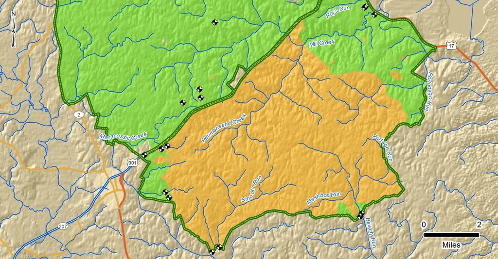
19 Installation Overview / Fast Facts Fort A.P. Hill, Virginia U.S. Army owned/operated Active since operational ranges 74,262 acres Phase I Conclusions Unlikely 128 operational ranges, 47,641 acres Inconclusive - (insufficient info regarding off range source-receptor interaction) 100 operational ranges, 26,621 acres
20 Piloting the Protocol The identified sources, pathways, and receptors at installation allow full implementation of Technical Protocol Training history means typical programmatic constituents potentially present on site Main programmatic transport pathways identified from multiple source types - Well defined surface water flow and discharge points for multi-seasonal sampling - Groundwater sampling at both source discharge and potential exposure points - Habitat conditions present for testing application of benthic macroinvertebrate dip net sampling Site location allows comparisons of protocol application between Fort A.P. Hill and USAPHC pilot site in Virginia Site is easily accessible for evaluation by USAEC, USAPHC, and USACE program managers and technical oversight


21 Surface Water System Approach Worst Case Approach - Heaviest Usage Multi-Seasonal Sampling Events BMI Composite Samples Five Representative Watersheds Weight of Evidence Evaluation Composite Surface Water Samples Composite Sediment Samples


22 Surface Water System Approach


23 Surface Water System Results Surface Water - 95 UCLM for all analytes below background and/or human and ecological screening criteria at range/installation boundary Sediment - All analytes below background and/or ecological screening criteria at range/installation boundary. Benthic -Diverse, optimal habitats identified - no statistical difference versus background critters are just fine Recent training below sampling locations adds new source component Currently revising technical approach to evaluate new source


24 Groundwater Approach Surficial aquifer wells at installation boundary designed to mimic potential receptor wells 2 Wells per watershed Surficial Aquifer Wells Existing deeper production wells sampled to evaluate potential surfical to deep migration 4 Wells Refined Shallow Aquifer CSM


25 Groundwater Approach

26 Groundwater Results All transportable analytes below background and/or human screening criteria at range/installation boundary in surficial aquifer and within the deeper production wells Lithology indicated low hydraulic conductivity in surficial aquifer even near surface water bodies Data evaluation complete report development underway
27 Lessons Learned in Proving the Concept Application of Worst Case Scenario application Similarities in models of source, pathway, and receptor between watersheds allowed for a focused approach Establishing a baseline for storm event sampling Installation of rain gauges, transducers and barometers in multiple watersheds identified parameters necessary for true storm transport Comparison of multi-seasonal benthic sampling results Multi-seasonal approach added value very dry dry season BMI habitat and SEM-AVS sediment analysis provided additional weight of evidence to support analytical data Benefits of USEPA Method only method to achieve QL 3x below screening criteria at site specific hardness
Operational Range Assessment Program (ORAP) Phase II Overview. Andrea Graham USACE, Baltimore District
 Phase II Overview. Andrea Graham USACE, Baltimore District") Operational Range Assessment Program (ORAP) Phase II Overview Andrea Graham USACE, Baltimore District andrea.a.graham@usace.army.mil Report Documentation Page Form Approved OMB No. 0704-0188 Public reporting
Operational Range Assessment Program (ORAP) Phase II Overview Andrea Graham USACE, Baltimore District andrea.a.graham@usace.army.mil Report Documentation Page Form Approved OMB No. 0704-0188 Public reporting
Operational Range Assessment Program (ORAP) Phase II Overview
 Phase II Overview") Operational Range Assessment Program (ORAP) Phase II Overview Andrea Graham USACE, Baltimore District andrea.a.graham@usace.army.mil 2009 Malcolm Pirnie, Inc. All Rights Reserved Army Environmental Military
Operational Range Assessment Program (ORAP) Phase II Overview Andrea Graham USACE, Baltimore District andrea.a.graham@usace.army.mil 2009 Malcolm Pirnie, Inc. All Rights Reserved Army Environmental Military
Operational Range Assessment Program (ORAP) Phase II Overview For Active Installations
 Phase II Overview For Active Installations") Operational Range Assessment Program (ORAP) Phase II Overview For Active Installations Andrea Graham USACE, Baltimore District andrea.a.graham@usace.army.mil Operational Range Assessment Program Background
Operational Range Assessment Program (ORAP) Phase II Overview For Active Installations Andrea Graham USACE, Baltimore District andrea.a.graham@usace.army.mil Operational Range Assessment Program Background
FINAL OPERATIONAL RANGE ASSESSMENT PROGRAM REPORT UNITED STATES ARMY GARRISON FORT BENNING, GEORGIA
 ARCADIS/Malcolm Pirnie 00 East Lombard Street Suite 1510 Baltimore, MD 21202 T: 410-20-068 F: 401-20-0491 www.arcadis-us.com FINAL OPERATIONAL RANGE ASSESSMENT PROGRAM REPORT UNITED STATES ARMY GARRISON
Prepared for: U.S. Army Environmental Command and U.S. Army Corps of Engineers Baltimore District. Printed on recycled paper
 FINAL Operational Range Assessment Program Phase I Qualitative Assessment Report U.S. Army Operational Range Assessment Program Qualitative Operational Range Assessments Prepared for: U.S. Army Environmental
FINAL OPERATIONAL RANGE ASSESSMENT PROGRAM PHASE I QUALITATIVE ASSESSMENT REPORT GERSTLE RIVER ARCTIC TEST SITE DELTA JUNCTION, ALASKA
 FINAL OPERATIONAL RANGE ASSESSMENT PROGRAM PHASE I QUALITATIVE ASSESSMENT REPORT GERSTLE RIVER ARCTIC TEST SITE DELTA JUNCTION, ALASKA AUGUST 2008 Prepared for: UNITED STATES ARMY CORPS OF ENGINEERS, BALTIMORE
Characterizing Munitions Constituents from Artillery and Small Arms Ranges
 Characterizing Munitions Constituents from Artillery and Small Arms Ranges Institute of Public Health Surface Water and Wastewater Program E2S2 Conference 9-12 May 2011 Approved for Public Release Report
FINAL OPERATIONAL RANGE ASSESSMENT PROGRAM PHASE I QUALITATIVE ASSESSMENT REPORT RAVENNA TRAINING AND LOGISTICS SITE NEWTON FALLS, OHIO
 FINAL OPERATIONAL RANGE ASSESSMENT PROGRAM PHASE I QUALITATIVE ASSESSMENT REPORT RAVENNA TRAINING AND LOGISTICS SITE NEWTON FALLS, OHIO FEBRUARY 2009 Prepared for: UNITED STATES ARMY CORPS OF ENGINEERS,
Operational Range Assessment Phase II Report Fort Indiantown Gap, Pennsylvania
 Operational Range Assessment Phase II Report Fort Indiantown Gap, Pennsylvania AUGUST 2013 Prepared for: US ARMY CORPS OF ENGINEERS - BALTIMORE DISTRICT 10 South Howard Street, Baltimore, MD 21201 Under
TREECS Overview, Validation, Example Applications M2S2 MC Seminar April 24, 2014
 TREECS Overview, Validation, Example Applications M2S2 MC Seminar April 24, 2014 Billy Johnson, ERDC Mark Dortch, LATA subcontractor Problem and Need! Military firing/training ranges contain munitions
Closed Castner Firing Range Remedial Investigation. Technical Project Planning (TPP) Meeting #4 07 November :00 AM 11:00 AM
 Meeting #4 07 November :00 AM 11:00 AM") Closed Castner Firing Range Remedial Investigation Technical Project Planning (TPP) Meeting #4 0 9:00 AM 11:00 AM Imagine result 2017 7 the November 1 Meeting Agenda Remedial Investigation (RI) Project
Closed Castner Firing Range Remedial Investigation Technical Project Planning (TPP) Meeting #4 0 9:00 AM 11:00 AM Imagine result 2017 7 the November 1 Meeting Agenda Remedial Investigation (RI) Project
Technical Memorandum Groundwater Quality Sampling, First 2010 Semiannual Event
 Kennedy/Jenks Consultants Technical Memorandum Groundwater Quality Sampling, First 2010 Semiannual Event Date: 30 July 2010 To: From: Subject: Amy Blain City of Longview Steve Misner Kennedy/Jenks Consultants
Range Environmental Vulnerability Assessment
 Code LFL Navy Annex Washington, D.C. 20380-1775 FINAL Range Environmental Vulnerability Assessment September 2009 6285024 Report Prepared By: Malcolm Pirnie, Inc. 8001 Irvine Center Drive Suite 1100 Irvine,
Paul Kirby, P.G. Daniel B. Stephens & Associates, Inc. with. Fayette County GCD Pecan Valley GCD. August 29, 2018
 Paul Kirby, P.G. Daniel B. Stephens & Associates, Inc. with Fayette County GCD Pecan Valley GCD August 29, 2018 Typical GCD Mission To provide for the conservation, preservation, protection, recharging,
Shallow Land Disposal Area (SLDA)
") Shallow Land Disposal Area (SLDA) Parks Township, PA Groundwater Monitoring Review and 2013 Sampling Results Pittsburgh and Buffalo Districts Building Strong US Army Corps of Engineers Building Strong
Shallow Land Disposal Area (SLDA) Parks Township, PA Groundwater Monitoring Review and 2013 Sampling Results Pittsburgh and Buffalo Districts Building Strong US Army Corps of Engineers Building Strong
Technical Memorandum Groundwater Quality Sampling, November 2010 Event
 Kennedy/Jenks Consultants Technical Memorandum Groundwater Quality Sampling, November 2010 Event Date: 10 March 2011 To: From: Subject: Amy Blain City of Longview Steve Misner Kennedy/Jenks Consultants
Qualitative Identification of Explosives. Avoid False Positive Results 24 April 2014
 Avoid False Positive Results 24 April 2014 Problem Statement Data users assume compounds are qualitatively identified Decisions based on reliable data using the following assumptions: DoD ELAP accreditation
Wellsite Salt Remediation: Subsoil Salinity Tool vs. Site- Specific Salt Risk Assessment? Erik J. Martin, Ph.D., DABT
 Wellsite Salt Remediation: Subsoil Salinity Tool vs. Site- Specific Salt Risk Assessment? Erik J. Martin, Ph.D., DABT October 2011 Co-Authors David Alberti, M.Sc., P.Geol. Stantec David.Alberti@stantec.com
LONGHORN ARMY AMMUNITION PLANT TEXAS EPA ID# TX
 LONGHORN ARMY AMMUNITION PLANT TEXAS EPA ID# TX6213820529 EPA REGION 6 CONGRESSIONAL DISTRICT 01 Harrison County Karnack Updated: July 2004 Site Description Location: Population: Setting: Hydrology:! The
Range Sustainment: Assessing Marine Corps Operational Small Arms Ranges (SARs)
") Range Sustainment: Assessing Marine Corps Operational Small Arms Ranges (SARs) May 6, 2009 Alicia Fogg Malcolm Pirnie, Inc. 2009 Malcolm Pirnie, Inc. All Rights Reserved Presentation Outline Introduction
Range Sustainment: Assessing Marine Corps Operational Small Arms Ranges (SARs) May 6, 2009 Alicia Fogg Malcolm Pirnie, Inc. 2009 Malcolm Pirnie, Inc. All Rights Reserved Presentation Outline Introduction
DEPARTMENT OF THE ARMY INSTALLATION MANAGEMENT COMMAND HEADQUARTERS, UNITED STATES ARMY GARRISON, PICATINNY
 t REPLY TO ATTENTION OF Environmental Affairs Division DEPARTMENT OF THE ARMY INSTALLATION MANAGEMENT COMMAND HEADQUARTERS, UNITED STATES ARMY GARRISON, PICATINNY PICATINNY ARSENAL, NEW JERSEY 07806-5000
Groundwater and Surface Water Overview of the Lochend Area, Alberta
 Groundwater and Surface Water Overview of the Lochend Area, Alberta The Lochend Industry Producers Group (LIPG) conducted a hydrogeological / hydrological study in the Lochend operating field. The objectives
Pebble Project Environmental Baseline Studies Technical Summary. APPENDIX A. Analytical Quality Assurance/Quality Control Review
 Pebble Project Environmental Baseline Studies 2004-2008 Technical Summary APPENDIX A. Analytical Quality Assurance/Quality Control Review TABLE OF CONTENTS TABLE OF CONTENTS... A-i ACRONYMS AND ABBREVIATIONS...A-ii
Pebble Project Surface Water Quality Program Streams, Seeps, and Ponds
 Day1_1445_Surface Water Quality_PLP_McCay.mp3 Pebble Project Surface Water Quality Program Streams, Seeps, and Ponds Mark Stelljes SLR International February 1, 2012 Outline Stream Program Overview Results
An Approach to Using Geochemical Analysis to Evaluate the Potential Presence of Coal Ash Constituents in Drinking Water
 2017 World of Coal Ash (WOCA) Conference in Lexington, KY - May 9-11, 2017 http://www.flyash.info/ An Approach to Using Geochemical Analysis to Evaluate the Potential Presence of Coal Ash Constituents
Overall Objective: Assess the quantity, quality, and distribution of surface and groundwater resources of NBAFS.
 Project: Watershed Assessment of New Boston Air Force Station to be completed by Emily DiFranco of the University of New Hampshire under the direction of Dr. William H. McDowell Problem Statement: New
Water Quality Protection Issues for New Water Supply Wells
 Water Quality Protection Issues for New Water Supply Wells Water Quality Protection Issues for New Water Supply Wells Project siting Facility water balance Supply well water quality analysis Supply well
Chapter 7 Shallow Ground Water Study Team
 Chapter 7 Shallow Ground Water Study Team Objective What are the shallow ground water issues of concern and what needs to be done? Introduction The Shallow Ground Water Study Team (Team) was formed to
Determination of Local Background Concentrations in Groundwater at an Industrial Site. Dissolved Arsenic, Iron and Manganese
 Determination of Local Background Concentrations in Groundwater at an Industrial Site Dissolved Arsenic, Iron and Manganese October 15, 2016 About the Presenter Tyler Joyce, C.Tech Project Manager Stantec
Fort Detrick Area B - Groundwater Remedial Investigation Work Plan
 Fort Detrick Area B - Groundwater Remedial Investigation Work Plan Fort Detrick Restoration Advisory Board Meeting September 22, 2010 Fort Detrick, Maryland History/Status Numerous groundwater investigations
Groundwater Monitoring Requirements of the CCR Rule What s Next?
 2017 World of Coal Ash (WOCA) Conference in Lexington, KY - May 9-11, 2017 http://www.flyash.info/ Groundwater Monitoring Requirements of the CCR Rule What s Next? Thomas A. Mann, PE SynTerra Corporation,
Proposed Plan Closed Sanitary Landfill
 Fort George G. Meade Proposed Plan Closed Sanitary Landfill Public Meeting May 18, 2016 1 18MAY2017 Public Meeting Purpose U.S. Army is inviting the public to comment on the proposed environmental actions
Wickes Manufacturing TCE Plume Site Mancelona, Michigan
 Wickes Manufacturing TCE Plume Site Mancelona, Michigan December 2017 What is TCE? Trichloroethylene (TCE) Common Industrial Solvent Known Human Carcinogen Federal and State Safe Drinking Water of 5 µg/l
Hilmar Cheese Company, Hilmar, Merced County, California. On behalf of Hilmar Cheese Company (HCC), Jacobson James & Associates, Inc.
, Jacobson James & Associates, Inc.") May 13, 2009 Mr. Jan Alfson California Regional Water Quality Control Board Fresno Branch Office 1685 E Street Fresno, CA 93706 Subject: Data Gap Work Plan Addendum Hilmar Cheese Company, Hilmar, Merced
May 13, 2009 Mr. Jan Alfson California Regional Water Quality Control Board Fresno Branch Office 1685 E Street Fresno, CA 93706 Subject: Data Gap Work Plan Addendum Hilmar Cheese Company, Hilmar, Merced
Clyde Mine Discharge/Tenmile Creek Water Quality Final Report
 Clyde Mine Discharge/Tenmile Creek Water Quality Final Report November 01, 2016 Background In follow-up to the Pennsylvania Department of Environmental Protection s (DEP) December 15, 2015, Tenmile Creek
Guidance for Remediation Program Landfills and Open Dumps. MSECA s Quarterly Meeting February 19, 2019
 Guidance for Remediation Program Landfills and Open Dumps MSECA s Quarterly Meeting February 19, 2019 Remediation Program Landfills and Open Dumps Guidance Resource www.idem.in.gov/cleanups/ files/tech_guidance_landfill
State Baseline Water Quality Programs for Oil & Gas Operations
 State Baseline Water Quality Programs for Oil & Gas Operations Dr. Robert Puls Director, Oklahoma Water Survey GWPC Annual Forum, Seattle, WA, Oct 6, 2014 10/30/2014 1 What is a Baseline Water Quality
Assessing Technical Impracticability in a Karst Setting at Anniston Army Depot
 Assessing Technical Impracticability in a Karst Setting at Anniston Army Depot Robert O Laskey, Elisabeth Hawley, Rula Deeb, Michael Kavanaugh (Malcolm Pirnie, Inc.) Bridget Lyons (US Army Environmental
Environmental Remediation Services Draft Focused FS FGGM 83/OU-1 Former Skeet Range
 Environmental Remediation Services Draft Focused FS FGGM 83/OU-1 Former Skeet Range 1 Presentation Agenda OU-1/FGGM-83, Former Trap & Skeet Range Focused Feasibility Study (FFS) OU-3/FGGM-87, Former Nike
Considerations for hydraulic fracturing and groundwater and surface water protection: lessons learned in the U.S.
 Considerations for hydraulic fracturing and groundwater and surface water protection: lessons learned in the U.S. Robert W. Puls, Ph.D. Director, Oklahoma Water Survey University of Oklahoma Hydraulic
Irrigation. Branch. Groundwater Quality in the Battersea Drainage Basin
 AGRICULTURE, FOOD AND RURAL DEVELOPMENT Irrigation Branch Groundwater Quality in the Battersea Drainage Basin Groundwater quality in the Battersea drainage basin was monitored between 1995 and 21 to characterize
Range Sustainment: Assessing Marine Corps Operational Small Arms Ranges (SARs)
") Range Sustainment: Assessing Marine Corps Operational Small Arms Ranges (SARs) May 6, 2009 Alicia Fogg Malcolm Pirnie, Inc. 2009 Malcolm Pirnie, Inc. All Rights Reserved Report Documentation Page Form
Range Sustainment: Assessing Marine Corps Operational Small Arms Ranges (SARs) May 6, 2009 Alicia Fogg Malcolm Pirnie, Inc. 2009 Malcolm Pirnie, Inc. All Rights Reserved Report Documentation Page Form
December 6, 2018 FID:
 State of Wisconsin DEPARTMENT OF NATURAL RESOURCES 101 S Webster St PO Box 7921 Madison, WI 53707-7921 Scott Walker, Governor Daniel L. Meyer, Secretary Telephone 608-266-2621 Fax 608-267-3579 TTY Access
Recomputation of Ambient Water Quality in the Santa Ana River Watershed
 Recomputation of Ambient Water Quality in the Santa Ana River Watershed 1993-2012 July 9, 2013 Prepared for: Basin Monitoring Program Task Force Basin Monitoring Program Task Force Project Director Mark
PIT LAKES LIABILITY OR LEGACY? David Allen (MBS Environmental) Karen Ganza (MBS Environmental) Rob Garnham (Groundwater Resource Management)
 Karen Ganza (MBS Environmental) Rob Garnham (Groundwater Resource Management)") PIT LAKES LIABILITY OR LEGACY? David Allen (MBS Environmental) Karen Ganza (MBS Environmental) Rob Garnham (Groundwater Resource Management) PRESENTATION OUTLINE Introduction Examples of Pit Lakes Important
PIT LAKES LIABILITY OR LEGACY? David Allen (MBS Environmental) Karen Ganza (MBS Environmental) Rob Garnham (Groundwater Resource Management) PRESENTATION OUTLINE Introduction Examples of Pit Lakes Important
Groundwater in the Santa Rosa Plain
 . Groundwater in the Santa Rosa Plain Marcus Trotta, PG, CHg Principal Hydrogeologist Sonoma County Water Agency Santa Rosa Plain Groundwater Sustainability Agency October 12, 2017 www.sonomacountywater.org
DATA QUALITY OBJECTIVES QUALITY ASSURANCE PROJECT PLAN. Christopher Garduño1
 11 QUALITY ASSURANCE CHAPTER 11: QUALITY ASSURANCE 1 Christopher Garduño1 1 Quality Assurance Specialist, U.S. Bureau of Reclamation, Mid Pacific Region, Sacramento, California 95825. Email: cgarduno@usbr.gov
Fort George G. Meade. Military Munitions Response Program Mortar Range Munitions Response Area. Public Meeting July 19, 2012
 Fort George G. Meade Military Munitions Response Program Mortar Range Munitions Response Area Public Meeting July 19, 2012 1 Public Meeting Purpose U.S. Army is inviting the public to comment on the proposed
RACER LANSING 1Q 2017 QUARTERLY PROGRESS REPORT
 RACER LANSING 1Q 2017 QUARTERLY PROGRESS REPORT Lansing Plants 2, 3 and 6 Lansing MI April 14, 2017 The information in this presentation is a combination of information shared with the MDEQ during the
DISTRIBUTION AND FATE OF ENERGETICS AT THE MMR KD ROCKET RANGE. Jay Clausen Senior Hydrogeologist/ Geochemist
 DISTRIBUTION AND FATE OF ENERGETICS AT THE MMR KD ROCKET RANGE Jay Clausen Senior Hydrogeologist/ Geochemist Presented to Distribution and Fate of Energetics on DoD Test and Training Ranges SERDP Research
Elisha Persaud Dr. Jana Levison School of Engineering, University of Guelph Scott MacRitchie Ministry of the Environment and Climate Change
 Elisha Persaud Dr. Jana Levison School of Engineering, University of Guelph Scott MacRitchie Ministry of the Environment and Climate Change Outline Background Case Study of Integrated Monitoring What Stands
Technical Memorandum
 Tucson Office 3031 West Ina Road Tucson, AZ 85741 Tel 520.297.7723 Fax 520.297.7724 www.tetratech.com Technical Memorandum To: Kathy Arnold From: Keith Thompson Company: Rosemont Copper Company Date: August
2015 Annual Monitoring Report Group 1 Sites (PICA-079) Picatinny Arsenal, New Jersey. Prepared for. Prepared by
 Picatinny Arsenal, New Jersey. Prepared for. Prepared by") 2015 Annual Monitoring Report, New Jersey Prepared for Prepared by EA Engineering, Science, and Technology, Inc., PBC Contract No. W91ZLK-13-D-0004-0009 March 2016 This page intentionally left blank 2015
2015 Annual Monitoring Report, New Jersey Prepared for Prepared by EA Engineering, Science, and Technology, Inc., PBC Contract No. W91ZLK-13-D-0004-0009 March 2016 This page intentionally left blank 2015
DIFFERENTIATION OF WATER SOURCES USING ANALYTICAL WATER CHEMISTRY DATA
 DIFFERENTIATION OF WATER SOURCES USING ANALYTICAL WATER CHEMISTRY DATA PRESENTED TO FOUNDATION PERFORMANCE ASSOCIATION JUNE 8, 2011 BY John Bryant, PH.D., P.G., CPG, P.E. All slides and this presentation
U.S. Department of the Interior U.S. Geological Survey
 Evaluation of stream quality and relations between stream biological conditions and environmental variables in urbanizing watersheds of northeastern Kansas Teresa Rasmussen, U.S. Geological Survey, Lawrence,
Investigating CCR Impacts: An Overview of the EIP Process in Tennessee Air & Waste Management Association Southern Section 2018 Annual Meeting and
 Investigating CCR Impacts: An Overview of the EIP Process in Tennessee Air & Waste Management Association Southern Section 2018 Annual Meeting and Conference Robert Wilkinson P.G.,CHMM September 27, 2018
Bridge-Seton Water Use Plan. Monitoring Program Terms of Reference. BRGMON-12 Bridge-Seton Metals and Contaminant Monitoring Program
 Monitoring Program Terms of Reference BRGMON-12 Bridge-Seton Metals and Contaminant Monitoring Program March 29, 2012 Bridge-Seton Water Use Plan Monitoring Program No. BRGMON-12 Bridge-Seton Metals and
DEVELOPMENT OF AQUIFER TESTING PLANS. Brent Bauman, P.G. / Erin Lynam, Aquatic Biologist
 DEVELOPMENT OF AQUIFER TESTING PLANS Brent Bauman, P.G. / Erin Lynam, Aquatic Biologist DEVELOPMENT OF AQUIFER TESTING PLANS Goals of Aquifer Testing What questions are we trying to answer Staff review
Environmental Data Management and Modeling, Niagara Falls Storage Site Lewiston, New York
 Environmental Data Management and Modeling, Niagara Falls Storage Site Lewiston, New York Eric Evans and Don DeMarco HydroGeoLogic, Inc. May 7, 2008 Mr. Eric Evans, M.Sc., P.G. is a Senior Hydrogeologist
Determining Infiltration Rates: Approaches, Challenges & Lessons Learned
 Determining Infiltration Rates: Approaches, Challenges & Lessons Learned May 16, 2017 Presented by Andrew Austreng, LHG Presentation Outline Overview of Site Characterization & Testing Pilot Infiltration
Range 17 - Trap and Skeet Range Soil Remediation
 Range 17 - Trap and Skeet Range Soil Remediation Presented by EA Engineering, Science, and Technology, Inc., PBC Michael Hertz 15 January 2014 1 Project Team and Stakeholders U.S. Army (Army) Office of
Application Note. Environmental. Agilent 1290 Infinity Binary LC. with ISET and fine-tuning. Agilent 1290 Infinity Binary LC.
 Seamless instrument-to-instrument method transfer of the EPA method 833A/B for nitroaromatics from an Agilent 12 Series LC to the Agilent 129 Infinity Binary LC using ISET Application Note Environmental
Drilling for Natural Gas in the Marcellus and Utica Shales: Environmental Regulatory Basics
 January 2014 Introduction This fact sheet provides a basic overview of natural gas drilling in the Marcellus and Utica Shale regions of Ohio and the potential environmental issues associated with these
Example Application of Long Term Stewardship for the Chlorinated Vapor Intrusion Pathway (and VOC sources)
") Example Application of Long Term Stewardship for the Chlorinated Vapor Intrusion Pathway (and VOC sources) Megan Hamilton Director of Vapor Intrusion and Risk Assessment EnviroForensics March 24, 2015
Example Application of Long Term Stewardship for the Chlorinated Vapor Intrusion Pathway (and VOC sources) Megan Hamilton Director of Vapor Intrusion and Risk Assessment EnviroForensics March 24, 2015
West Placer Groundwater Sustainability Agency Public Meeting February 8, 2018
 West Placer Groundwater Sustainability Agency Public Meeting February 8, 2018 1 Agenda 1. Public comment period 2. Public Information: Grant opportunities 3. GSA Discussion Items 4. GSP Discussion Items
W12A Landfill Groundwater, Leachate, Water Well, Landfill Gas and Surface Water Quality Monitoring Program
 W12A Landfill Groundwater, Leachate, Water Well, Landfill Gas and Surface Water Quality Monitoring Program The groundwater, leachate, water well, landfill gas and surface water monitoring programs are
Continuous Instream Monitoring Report (CIMR) Most recent revision: 9/18/2014
 Most recent revision: 9/18/2014") Continuous Instream Monitoring Report (CIMR) Most recent revision: 9/18/2014 Revised by: Jeffery Butt STATION DESCRIPTION: STREAM CODE: 24704 STREAM NAME: Deep Hollow Run SITE CODE: 66909423 SITE NAME:
Continuous Instream Monitoring Report (CIMR) Most recent revision: 9/18/2014 Revised by: Jeffery Butt STATION DESCRIPTION: STREAM CODE: 24704 STREAM NAME: Deep Hollow Run SITE CODE: 66909423 SITE NAME:
Statistical Method Selection Certification
 Statistical Method Selection Certification R.M. Heskett Station Prepared for Montana-Dakota Utilities Co. October 2017 Statistical Method Selection Certification R.M. Heskett Station Prepared for Montana-Dakota
Globeville Landing Outfall Surface Water. December 12, 2017 Andrew Ross, Jon Novick Denver Department of Public Health & Environment
 Globeville Landing Outfall Surface Water December 12, 2017 Andrew Ross, Jon Novick Denver Department of Public Health & Environment Introductions Andrew Ross Environmental Program Manager, DDPHE Jon Novick
Isotope Hydrology Investigation of the Pawcatuck Watershed. Principle Investigators. Anne I. Veeger
 Isotope Hydrology Investigation of the Pawcatuck Watershed Principle Investigators Anne I. Veeger Introduction There are three new research projects for the FY1999 annual research program for the Water
Developing a Site Characterization Plan
 Developing a Site Characterization Plan NEWMOA Back to Basics Part 1: Developing the CSM and Site Characterization Plan Ryan A. Wymore, PE CDM Smith Denver, CO March 27-29, 2018 Introduction Initial CSM
Pilot Study Report. Z-92 Uranium Treatment Process
 Pilot Study Report for Z-92 Uranium Treatment Process conducted at the Mountain Water & Sanitation District, Conifer, Colorado Revised November 11, 4 Page 2 Executive Summary Mountain Water & Sanitation
Draft. Scope of Work. Task 1 RCRA Facility Investigation and Corrective Measures Study
 Draft Scope of Work Task 1 RCRA Facility Investigation and Corrective Measures Study DRAFT Table of Contents Task 1 RCRA Facility Investigation and Corrective Measures Study... 2 Scope of Work:... 2 Technical
Innovative Options for Ex-Situ Removal of Perchlorate and Explosives in Groundwater
 22/03/2004 1 Innovative Options for Ex-Situ Removal of Perchlorate and Explosives in Groundwater National Defense Industry Association 30 th Environmental and Energy Symposium and Exhibition April 7, 2004
Conceptual Site Models for Environmental Investigations and Remediation
 Remediation Technology Symposium (RemTech) 2012 Conceptual Site Models for Environmental Investigations and Remediation October 18, 2012 Tai T. Wong, P.Eng. Authors and Presenter Authors: James Carss,
Application of Rapid Bioassessments in Phase I MS4 Permit Monitoring
 Application of Rapid Bioassessments in Phase I MS4 Permit Monitoring Presented by Cathy Matthews and Cody Whittenburg Code Compliance/Environmental October 2016 Presentation Objectives Review monitoring
Stormwater Infiltration using Dry Wells as a Low Impact Development (LID) Tool
 Tool") Stormwater Infiltration using Dry Wells as a Low Impact Development (LID) Tool Presented by: Connie Nelson, CFM City of Elk Grove/Willdan Engineering Today s Discussion Background California s water situation
Stormwater Infiltration using Dry Wells as a Low Impact Development (LID) Tool Presented by: Connie Nelson, CFM City of Elk Grove/Willdan Engineering Today s Discussion Background California s water situation
APPENDIX I PRELIMINARY RISK ASSESSMENT KN2/4040/P Q/SI-TXT/(4/1/02/9 :50 AM)
") APPENDIX I PRELIMINARY RISK ASSESSMENT KN2/4040/P237-238Q/SI-TXT/(4/1/02/9 :50 AM) Technical Memorandum From: Debbi Freer Reviewed by : Paul F. Goetchius, DVM To : Possible Range, Parcel 237Q-X and Impact
APPENDIX I PRELIMINARY RISK ASSESSMENT KN2/4040/P237-238Q/SI-TXT/(4/1/02/9 :50 AM) Technical Memorandum From: Debbi Freer Reviewed by : Paul F. Goetchius, DVM To : Possible Range, Parcel 237Q-X and Impact
2018 Monitoring Strategy for the Des Plaines River Watershed. Purpose
 2018 Monitoring Strategy for the Des Plaines River Watershed Purpose This Monitoring Strategy for the Des Plaines River Watershed in Lake County Illinois was developed by the Monitoring Committee of the
Lessons Learned from the Installation and Monitoring of a Permeable Reactive Barrier at the Lake City Army Ammunition Plant, Independence, MO
 Lessons Learned from the Installation and Monitoring of a Permeable Reactive Barrier at the Lake City Army Ammunition Plant, Independence, MO Presented by Kevin Keller, PG, CGWP - Shaw E&I, Inc. Thomas
The Continued Maturation of Environmental Assessments Over the Last Two Decades: End-of-Pipe to Watershed Strategies
 The Continued Maturation of Environmental Assessments Over the Last Two Decades: End-of-Pipe to Watershed Strategies William L. Goodfellow, Jr. Brief History of Biomonitoring Ellis (1937) Detection and
Draft Fact Sheet Butte County Stable Isotope Recharge Study
 Agenda Item #4 Draft Fact Sheet Butte County Stable Isotope Recharge Study Purpose of the Study: To develop a better understanding of how various water sources contribute to recharge of Butte County groundwater.
Assessing Water Use and Availability Trends in New Hampshire
 Assessing Water Use and Availability Trends in New Hampshire Brandon Kernen, PG NH Department of Environmental Services (603) 271-0660/Brandon.Kernen@des.nh.gov Existing Groundwater Use and Availability
Exploring Dynamic Interactions Between Surface Water and Groundwater at a Point Bar System in the Muskegon River Watershed
 Exploring Dynamic Interactions Between Surface Water and Groundwater at a Point Bar System in the Muskegon River Watershed Introduction The quality of critical surface water resources is linked to the
GW/SW Interactions: Developing Conceptual Site Models of Organism Exposures. Robert Ford
 GW/SW Interactions: Developing Conceptual Site Models of Organism Exposures Robert Ford Office of Research and Development National Risk Management Research Laboratory, Cincinnati, OH USEPA Region 10 GW-SW
Evolution of Dissolved Arsenic in Groundwater Downgradient of a Coal Ash Impoundment
 2007 World of Coal Ash (WOCA), May 7-10, 2007, Northern Kentucky, USA http://www.flyash.info Evolution of Dissolved Arsenic in Groundwater Downgradient of a Coal Ash Impoundment Bruce R. Hensel 1 and Eric
Aquifer Storage and Recovery Regional Study
 Aquifer Storage and Recovery Regional Study ASR Regional Study Ecological Risk Assessment Mark Shafer, P.E., USACE US Army Corps of Engineers 2 Presentation Outline Critical Issues (identified in 1999-2002)
GROUNDWATER ASSESSMENT MONITORING REPORT APRIL 2014
 Tennessee Valley Authority John Sevier Fossil Plant GROUNDWATER ASSESSMENT MONITORING REPORT APRIL 2014 Prepared by Amos L. Smith, PG Chattanooga, Tennessee June 4, 2014 DOCUMENT CERTIFICATION I certify
The Impact of Nonpoint Source Contamination on the Surficial Aquifer of the Delmarva Peninsula
 The Impact of Nonpoint Source Contamination on the Surficial Aquifer of the Delmarva Peninsula Judith M. Denver National Water-Quality Assessment Program (NAWQA) September 28,2010 U.S. Department of the
SPECIFICATION NO.1197S Addendum No.4 Attachment D. Appendix L- Ground Water Quality Data and Revised Construction Groundwater Discharge Plan
 SPECIFICATION NO.1197S Addendum No.4 Attachment D Appendix L- Ground Water Quality Data and Revised Construction Groundwater Discharge Plan Page 1 of 2 Specification No. 1197S Addendum No. 4 ATTACHMENT
REPORT ADDENDUM ENVIRONMENTAL INVESTIGATION, RISK ASSESSMENT AND ALTERNATIVES ANALYSIS FORT DES MOINES DES MOINES, IOWA
 CONTRACT NO. DAAA15-90-D-0014 DELIVERY ORDER NO. 0003 REPORT ADDENDUM ENVIRONMENTAL INVESTIGATION, RISK ASSESSMENT AND ALTERNATIVES ANALYSIS FORT DES MOINES DES MOINES, IOWA SUBMITTED TO: U.S. ARMY ENVIRONMENTAL
ANNUAL GROUNDWATER MONITORING AND CORRECTIVE ACTION REPORT FOR 2018 JAMES RIVER POWER STATION (JRPS) Prepared for:
 Prepared for:") ANNUAL GROUNDWATER MONITORING AND CORRECTIVE ACTION REPORT FOR 2018 JAMES RIVER POWER STATION (JRPS) Prepared for: City Utilities of Springfield 301 E. Central Street Springfield, Missouri Prepared by:
ANNUAL GROUNDWATER MONITORING AND CORRECTIVE ACTION REPORT FOR 2018 JAMES RIVER POWER STATION (JRPS) Prepared for: City Utilities of Springfield 301 E. Central Street Springfield, Missouri Prepared by:
Numerical Groundwater Flow Model Report. Caloosa Materials, LLC 3323 Gulf City Road Ruskin, Florida 33570
 Numerical Groundwater Flow Model Report Caloosa Materials, LLC 3323 Gulf City Road Ruskin, Florida 33570 GHD 2675 Winkler Ave Suite 180 Fort Myers, FL 33901 11138224 Report July 27, 2017 Table of Contents
Pennsylvania Pequea and Mill Creek Watershed Section 319 National Monitoring Program Project
 Pennsylvania Pequea and Mill Creek Watershed Section 319 National Monitoring Program Project Figure 36: Pequea and Mill Creek (Pennsylvania) Watershed Project Location 231 T-1 C-1 T1-3 T-4 C1-2 T2-3 T-2
In Situ Thermal NAPL Remediation at the Northeast Site Pinellas Environmental Restoration Project
 ABSTRACT In Situ Thermal NAPL Remediation at the Northeast Site Pinellas Environmental Restoration Project R. Juhlin, M. Butherus S.M. Stoller Corporation 2597 B ¾ Road, Grand Junction, C0 81506 USA The
Balancing the Costs of Short-Term Cleanup and Long-Term Stewardship During Remedial Planning
 Balancing the Costs of Short-Term Cleanup and Long-Term Stewardship During Remedial Planning Jeff Carnahan Vice President Chief Technical Officer EnviroForensics, Inc. Example Clean-Up v. LTS Operated
Steven T. Downey, PE, PMP; Xihong Zhai, PhD, PE; The Shaw Group Richard Meadows, USACE, Huntington, WV
 Field-Scale Treatability Study for Enhanced In Situ Bioremediation of Explosives in Groundwater: BioBarrier Installation and Hot Spot Treatment Using DPT Injection Steven T. Downey, PE, PMP; Xihong Zhai,