Rough Proportionality It s State Law!
|
|
|
- Coleen Kathryn Craig
- 6 years ago
- Views:
Transcription

1 Rough Proportionality It s State Law! Presentation by: Dan Sefko, FAICP, Freese and Nichols, Inc. Edmund Haas, AICP, Freese and Nichols, Inc. Alan D. Greer, P.E., Freese and Nichols, Inc. Texas APA Conference February 6, 2009
2 Discussion Agenda: 1. Introduction 2. Why are we here? 3. Legal Considerations 4. Roadway proportionality 5. Water and Wastewater proportionality 6. Drainage proportionality 7. Closing Comments
 far, far way We ended up with")
3 Why Are We Here? A long time ago, in a galaxy (State) far, far way We ended up with Chapter of the Texas Local Government Code.
4
5 Although enacted in 2005, cities are just now beginning to experience the impact of this law (similar to many of our state laws affecting cities). We have addressed proportionality changes in several DFW cities. So what are the issues facing cities?
6 How do you measure proportionality? Who prepares the analysis or study? Is it a study or an approval? How long can the city take to prepare or decide on the analysis? Are parks and trails subject to this chapter? Does a TIA establish proportionality? Who pays for the analysis, study or determination?
7 What if you already have impact fees under Chapter 395? What if you do not? If your subdivision regulations require it (i.e., it is on-site) are you still subject to proportionality? Where should your proportionality processes be located? How do pre-existing drainage laws affect proportionality requirements?
8 Legal Aspects of Legal Issue of Rough Proportionality Rough Proportionality That Should be Discussed with Your Attorney Proportionality is a legal concept that must be translated into a concrete set of rules and procedures Every development exaction is subject to test
9 Development Exactions Preview Nexus test: Nollan Rough proportionality: Dolan Adjudicative decisions Proportional to nature and extent of development Individualized (advance) determination Flower Mound Case (2005) Off-site perimeter road exaction Disproportionate under Dolan Damages awarded
10 Proportionality Statute TLGC sec Law implementing Flower Mound Applies to exactions of land, facilities or fees No limitation to off-site improvements Applies to all types of facilities City engineer initially must make proportionality determination
11 Proportionality Statute cont d Automatic right of appeal to City Council Council must make decision 30 days after hearing Appeal to District or County Court City can t require waiver as condition Doesn t affect authority or procedures under ch. 395
12 Municipal Responses Business as usual: apply exaction standards as written in subdivision ordinance Develop proportionality measure and incorporate procedures Develop impact fees for one or more facilities and integrate with subdivision exactions
13 Roadway Proportionality Presented by: Eddie Haas, AICP Freese and Nichols, Inc. Sefko Planning Group
14 Rough Proportionality Determination Two Approaches Traffic impact assessments (TIA) - Caution! Valuable technical tool Limited to extent of prescribed area Full system impacts not considered System analysis Examines off-site impacts Approach akin to impact fee methodology Development of system CIP and its cost to provide Based on growth, determination of unit cost impact Enables structured approaches to all assessments
15 System-wide Traffic Implication of New Development Traffic from new development impacts the roadway system Traffic impact not contained to adjacent roadway MPO Workplace Surveys and MTP travel statistics document lengths for various land uses and trip types
16 System Approach Elements for Proportionality Analyses Service Units - Vehicle-Mile Establish system capacity Ability to relate roadway projects to demand Link development to improvements (trip length) PM Peak Hour Establish LOS adequacy
17 System Approach Elements for Proportionality Analyses Service Units (vehicle-miles) Measure of roadway capacity by facility type Roadway Facility Vehicle-Mile Lane Capacities Hourly Vehicle-mile Capacity Roadway Facility per Lane Mile of Roadway Facility Divided Principal Arterial 675 Divided Minor Arterial 625 Divided Collector 550 One-Way Roadway 675 Undivided Principal Arterial 625 Undivided Minor Arterial 600 Undivided Collector 500 Source: NCTCOG. Level of Service D. For Example: 625 vehicles per hour per lane x 4 lanes x 2 miles = 5,000 vehicle-miles
18 System Approach Elements for Proportionality Analyses Service Units (vehicle-miles) Measure of roadway capacity by facility type Land Use Equivalency Table Trip Rate (vehicles) ITE Trip Generation Trip Length (miles) Workplace survey or travel statistics Categorized by land use types Adjusted for primary trip purpose
19 Land Use/Vehicle-Mile Equivalency Table DEVELOPMENT TRIP LOCAL TRIP TOTAL SERVICE UNITS CATEGORY LAND USE UNITS (X) RATE LENGTH (mi.) (VEH-MI / DEV UNIT) RESIDENTIAL OFFICE LOCALIZED SINGLE-FAMILY DETACHED D.U APARTMENT/TOWNHOUSE D.U RETIREMENT COMMUNITY D.U INDEPENDENT SR. LIVING FACILITY D.U GENERAL OFFICE BLDG 1000 GFA CORPORATE HEADQUARTERS BLDG 1000 GFA MEDICAL-DENTAL OFFICE BLDG 1000 GFA U.S. POST OFFICE 1000 GFA BUSINESS PARK 1000 GFA RESEARCH AND DEVELOPMENT CENTER 1000 GFA COMMERCIAL 66% RETAIL/SHOPPING CENTER 1000 GLA % QUALITY RESTAURANT 1000 GFA % FAST FOOD RESTAURANT WITH DRIVE-THROUGH 1000 GFA % HIGH TURNOVER RESTAURANT 1000 GFA % GAS STATION w/convenience MARKET 1000 GFA % CONVENIENCE MARKET WITH GASOLINE PUMPS 1000 GFA GROCERY/SUPERMARKET 1000 GFA DISCOUNT CLUB 1000 GFA AUTO SALES 1000 GFA VIDEO RENTAL STORE 1000 GFA % BANK 1000 GFA % PHARMACY/DRUGSTORE WITH DRIVE-THROUGH 1000 GFA APPAREL STORE 1000 GFA MOVIE THEATER SCREENS % FURNITURE STORE 1000 GFA % HOME IMPROVEMENT SUPERSTORE 1000 GFA HARDWARE/PAINT STORE 1000 GFA BUILDING MATERIALS/LUMBER STORE 1000 GFA NURSERY (GARDEN CENTER) 1000 GFA NURSERY (WHOLESALE) 1000 GFA HOTEL ROOMS MOTEL ROOMS ALL SUITES HOTEL ROOMS AUTO CARE CENTER 1000 GFA QUICK LUBE SHOP 1000 GFA AUTO PARTS SALES 1000 GFA % TIRE SUPERSTORE 1000 GFA WHOLESALE TIRE STORE 1000 GFA MINI-WAREHOUSE/SELF STORAGE 1000 GFA INDUSTRIAL GENERAL LIGHT INDUSTRIAL 1000 GFA MANUFACTURING 1000 GFA INDUSTRIAL PARK 1000 GFA WAREHOUSING 1000 GFA INSTITUTIONAL PRIVATE SCHOOL (K-12) STUDENTS JUNIOR/COMMUNITY COLLEGE STUDENTS UNIVERSITY/COLLEGE STUDENTS DAY CARE CENTER STUDENTS HOSPITAL BEDS NURSING HOME BEDS ASSISTED LIVING CENTER BEDS PLACE OF WORSHIP 1000 GFA
20 System Approach Elements for Proportionality Analyses Service Units (vehicle-miles) Measure of roadway capacity by facility type Land Use Equivalency Table DEVELOPMENT TRIP LOCAL TRIP TOTAL SERVICE UNITS CATEGORY LAND USE UNITS (X) RATE LENGTH (mi.) (VEH-MI / DEV UNIT) LOCALIZED RESIDENTIAL SINGLE-FAMILY DETACHED D.U Example: The service unit generation of 10 Single-Family Residential Units 10 du x 1.01 trips/du x 3.15 miles = vehicle-miles
21 Proportionality Applications Roadway Dedication (VMT supply vs. VMT demand assessment) Cost Approach Cost of improvements vs. system impact Land dedication: cost of dedication vs. cost of service
22 Roadway Dedication Methodology Step 1: Calculate vehicle-miles of capacity provided by proposed development. Determine roadway class as per the Thoroughfare Plan, length of improvements (in miles) and number of lanes. Length of Improvement x No. of Lanes x Hourly Capacity = Development (in miles) per lane Vehicle-miles Supplied Step 2: Calculate vehicle-miles of demand generated by proposed development using the equivalency table. Determine land uses, size of development, and appropriate service unit equivalent (SUE). No. of Development x Vehicle-miles per = Development Units development unit Vehicle-miles Demand Step 3: Compare vehicle-miles supply with demand: If VM Demand > VM Supply ; then exaction is proportional and justified. If VM Supply > VM Demand ; then City participation to be considered.
23 Cost Approach Cities with Impact Fee System $/VM x Size of Development x SUE = $ of system impact Compare $ of dedication vs. $ of system impact Cities without an Impact Fee System Identify cost of necessary improvement vs. cost of dedication Or more comprehensively: System of improvements (build out less existing system) Determine cost of improvements and capacity provided Determine $/VM Determine $ of system impact ($/VM x Size of dev. X SUE) Compare $ of dedication vs. $ of system impact
24 Case Study 1: Mapleshade Tract Proposed Development 165, square feet of retail uses 15.2 ac.

25 Case Study 1: Mapleshade Tract Proposed Improvements Type D 4-lane divided arterial 15.2 ac.
 x 4 lanes x 625 veh/lane = 591.85 Less (623.29 /5,280 /mi) x 2 lanes x 625 veh/lane =-147.56 Total vehicle-miles supplied 444.")
26 Case Study 1: Mapleshade Tract Proportionality Calculation Step 1: Vehicle-Miles of Capacity Supplied Mapleshade Lane; 4-lane divided roadway, 1, ac. (1,250 /5,280 /mi) x 4 lanes x 625 veh/lane = Less ( /5,280 /mi) x 2 lanes x 625 veh/lane = Total vehicle-miles supplied vms Step 2: Vehicle-Miles of Demand Generated by the Site 165, SF x 2.25 trips/1,000 SF of dev. x 1.28 miles = Total vehicle-miles of demand vmd Step 3: Supply/Demand Comparison vmd > vms The projected demand of the site is greater than supply provided; therefore the exaction by the City is proportional and justified.

27 Case Study 2: Liberty Cypress Business Park Proposed Development 190,871 square feet of office park 22.2 ac.
28 Case Study 2: Liberty Cypress Business Park Proposed Improvements Liberty Grove Rd. - Type A 6-lane divided arterial (110 ROW); 25 ROW dedication. SH HWY multimodal corridor; 350 ROW dedication.
29 Case Study 2: Liberty Cypress Business Park Proportionality Calculation Step 1: Value of ROW dedication Liberty Grove: 25 ROW x 1403 SH 190: 350 ROW x 1403 Total ROW Dedication = 35,077sf = 495,148sf 530,225sf Appraised Value of property: $0.22/sf Value of ROW Dedication: 530,225 x $0.22/sf = $116,649 Step 2a: Vehicle-Miles of Demand Generated by the Site 190,871 SF x 1.5 trips/1,000 SF of dev. x 4.00 miles = 1, Total vehicle-miles of demand 1, vmd Step 2a: Cost of Impact Generated by the Site 1, VM x $1,289.18/VM = $1,476,402 Step 3: Cost of Dedication/Impact Comparison $1,476,402 > $116,649 The projected cost of the site impact is greater than the dedication; therefore the exaction by the City is proportional and justified.


30 Case Study 3: Town Center Rough Proportionality System 15.2 ac.

31 Case Study 3: Town Center Proposed Development 235,610 square feet of mixed-uses Proposed Improvements CR91; Major Collector; 4-lane divided roadway CR89; Minor Collector 2-lane undivided roadway
32 Case Study 3: Town Center Proportionality Calculation Step 1: Vehicle-Miles of Capacity Supplied CR91; 4-lane divided roadway, 1, linear feet (1,488 /5,280 /mi) x 4 lanes x 550 veh/lane = Less Portion of Brookshire s ( /5,280 /mi) x 2 lanes x 550 veh/lane = CR89; 2-lane undivided roadway, linear feet ( /5,280 /mi) x 2 lanes x 500 veh/lane = Total Vehicle-miles Supplied vms Step 2: Vehicle-Miles of Demand Generated by the Site 46,910sf /1,000sf dev. unit x 3.06 veh-miles/dev. unit = ,000sf /1,000sf dev. unit x 3.06 veh-miles/dev. unit = ,700sf /1,000sf dev. unit x 5.08 veh-miles/dev. unit = ,000sf /1,000sf dev. unit x veh-miles/dev. unit = ,000sf /1,000sf dev. unit x veh-miles/dev. unit = ,000sf /1,000sf dev. unit x 3.06 veh-miles/dev. unit = ,000sf /1,000sf dev. unit x 4.94 veh-miles/dev. unit = Vehicle-miles of Demand vmd Step 3: Supply/Demand Comparison vm d > vm s Exaction is proportional and justified.
33 Case Study 3: Town Center System Cost of Proposed Development Step 1: Vehicle-Miles of Demand Generated by the Site 46,910sf /1,000sf dev. unit x 3.06 veh-miles/dev. unit = ,000sf /1,000sf dev. unit x 3.06 veh-miles/dev. unit = ,700sf /1,000sf dev. unit x 5.08 veh-miles/dev. unit = ,000sf /1,000sf dev. unit x veh-miles/dev. unit = ,000sf /1,000sf dev. unit x veh-miles/dev. unit = ,000sf /1,000sf dev. unit x 3.06 veh-miles/dev. unit = ,000sf /1,000sf dev. unit x 4.94 veh-miles/dev. unit = Vehicle-miles of Demand vmd Step 2: System Impact Costs of Proposed Development VMd x $1,385.00/service unit = $1,275, CR 91: 90 x 1, = 133,925.40sf x $0.34/sf = -$45, Less CR91: 45 x = 32,323.50sf x $0.34/sf = -$10, CR 89: 60 x = 41,546.40sf x $0.34/sf = -$14, Credit from ROW Dedication Cost Contribution from Development: $1,226, $48,670.42
34 Municipal Preparedness For Cities with impact fee systems: Basics in place Establish methodology/approach of proportionality test, system approach of analyses, information required as part of application, and role of city in proportionality determinations. For Cities without impact fees Consider preparation of a proportionality study Establish methodology/approach of proportionality test, system approach of analyses, information required as part of application, and role of city in proportionality determinations. You re ready for challenges!
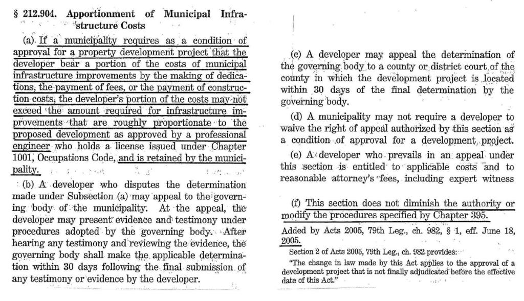
35 Water & Sewer Utility Proportionality Presented by: Alan Greer, P.E. Freese and Nichols, Inc.
36 New Development System Impact Infrastructure adequate to support development Application of minimum standards Sizing to meet flow requirements of development Oversizing for future development Development agreement City participation Pro Rata agreement Reimbursement on developer s impact fee Reimbursement on future impact fees
37 Determining New Development s Fair Share Develop clear and flexible Participation Policy Define developer s responsibility Address City participation Reimbursement instrument options Development agreements
38 Determining New Development s Fair Share Projects without impact fee Determine developer s loading Standard per capita if lots known Land use estimations I/I allowances for sewer Peaking factors Fire flow
39 Determining New Development s Fair Share Comparison to capacity or buildout flow Sewer: Manning s flow Modeled dynamic flow Buildout loading based on projected development Water: Estimated capacity based upon max friction loss Capacity based upon modeled system Buildout loading based on projected development
40 Determining New Development s Fair Share Comparison to minimum standard Policy to determine responsibility for this Reimbursement for oversizing Reimbursement for cost over minimum standard Reimbursement by Pro Rata agreement Devel. % = Loading/Capacity or Loading/B.O. Flow
41 Determining New Development s Fair Share Projects with impact fees Accounting for impact fees separate from reimbursement Collect all impact fees Developer still responsible for fair share Determine number of service units of loading Based upon number of meters and meter size Equivalency table (see next slide for example)
42 Determining New Development s Fair Share Example Equivalency Table Meter Size 3/4 x 5/8 Water Service Unit Equivalents / /
43 Determining New Development s Fair Share Comparison to minimum standard Comparison to capacity or buildout loading Same as without impact fees, except translate to service units Reimbursement for oversizing Governed by LGC Chapter 395 Reimbursement on developer s impact fee Reimbursement from future impact fees Reimbursement for size over minimum standard Reimbursement as % of IF CIP project Based upon IF collection rate

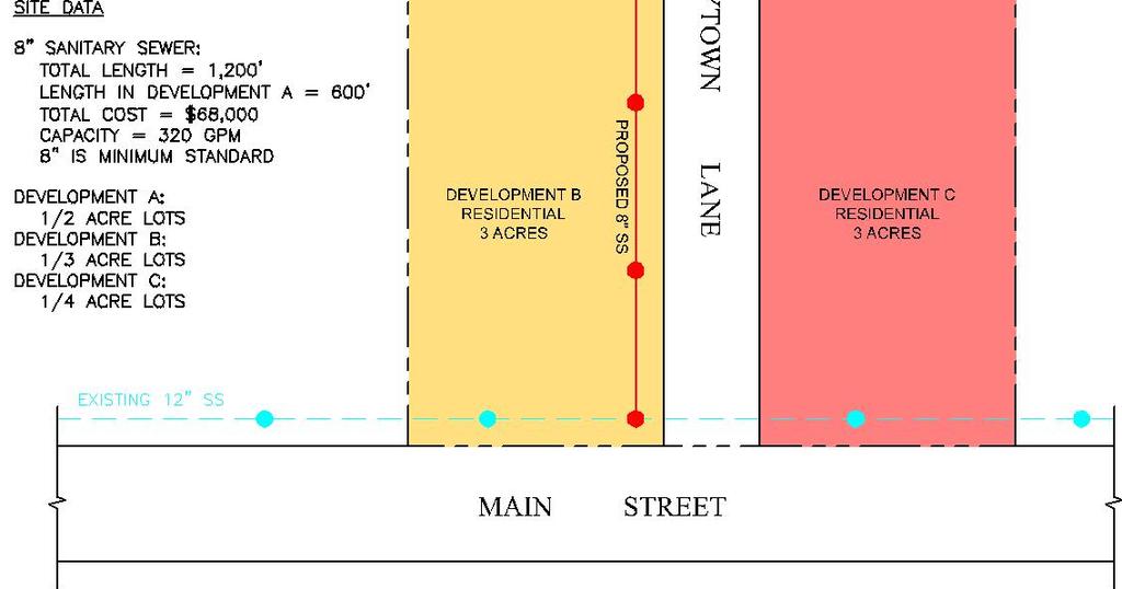
44 Sample Case #1
45 Determine Developer s Loading Sample Case #1 Development A # Lots = 9x2 = 18 Assumed per capita = 80 gpcd Assumed occupancy = 3 persons per household Loading = 18x80x3 = 4,320 gpd = 3 gpm
46 Sample Case #1 Comparison to buildout flow Total Lots = 9x2 + 3x3 + 3x4 = 39 Lots Assumed per capita = 80 gpcd Assumed occupancy = 3 persons per household Loading = 39x80x3 = 9,360 gpd = 6.5 gpm
47 Developer A s fair share Sample Case #1 Responsible for line through Development A = $34,000 Responsible for proportionate share of segment through Developments B & C Proportionate percent = 3 gpm/6.5 gpm = 46% Proportionate share = 46% x $34,000 = $15,640 Developer A s total fair share = $49,640 Reimbursement for remaining cost by: City participation Pro Rata agreement

48 Sample Case #2
49 Determine service units of loading Sample Case #2 No. ¾ x 5/8 meters = No. Lots = 18 service units Comparison to buildout services units No. ¾ x 5/8 meters = No. Lots = 39 service units
50 Reimbursement analysis Available impact fees Sample Case #2 Developer A = 18 - ¾ x 5/8 meters = 18 x $1,000 = $18,000 (Developer A pays impact fee) Developer B = 9 ¾ x 5/8 meters = 9 x $1,000 = $9,000 Developer C = 12 ¾ x 5/8 meters = 12 x $1,000 = $12,000 Total potential impact fee collections = $39,000
51 Impact fee reimbursable cost Sample Case #2 Total reimbursable cost = IF CIP cost x % collection = $50,000 x 60% = $30,000 Reimbursement from Developer A s impact fees = Developer A loading/total Loading x $30,000 = 18 service units/39 service units x $30,000 = $13,846 Reimbursement from future impact fees = Developers B & C loading/total Loading x $30,000 = 21 service units/39 service units x $30,000 = $16,154 Total reimbursement to Developer A = $30,000
52 Drainage Proportionality
53 Drainage Issues Current Drainage Ordinances and Criteria Legal Issues Downstream and Upstream Impacts from increased runoff Upsizing for fully-developed conditions Methods to determine and size proportional share of capacity Analyzing and accommodating for fully developed conditions but constructing facilities for individual site runoff City-wide/Regional Master Plans
54 Existing Ordinances in North Texas Most ordinances require sizing for fully developed watershed conditions. Most ordinances do not allow increase in runoff downstream above existing conditions. Typically, development pays for its own drainage with on-site detention or individual site improvements. Some developments are looking at potential downstream impacts and are building facilities to accommodate fully developed watershed conditions Some Cities are doing watershed studies to develop regional stormwater plans So, what is being done for proportional share??
55 Downstream & Upstream Assessments Evaluate impacts of increased runoff from site to determine if any DS or US impacts occur due to new development and size on-site facilities accordingly Legally, a site still has to accept stormwater that flows onto the site, as long as it is coming onto the site in the same manner as pre-developed conditions (concentration, velocity, etc.) Legally, a site should not cause flooding damage downstream due to proposed development So, what is being done for proportional share??
56 Options that are being done for Proportional Share Make it a site specific issue Analyze for fully developed, but build for existing plus increase from project Accommodate fully developed conditions by allowing for easements and future expansion of facilities Joint participation with Cities for regional solutions Developing funding alternatives: Drainage Utility Fees Impact Fees Developer Agreements
57 Ordinance Example Downstream Impact Assessment The downstream impacts of proposed development must be carefully evaluated to show that design criteria established in this Ordinance and the Stormwater Design Manual are met. The purpose of the downstream assessment is to protect downstream properties from increased flooding, to protect downstream channels from increased erosion potential due to upstream development, and to protect public health and safety. The assessment shall extend from each outfall of a proposed development to a major stream (FEMA-defined floodplain), to a storm water facility identified by the City as having fully-developed flow capacity or to a point designated by the City Engineer, whichever is the nearest point downstream. Runoff computations shall be based upon fully developed watershed conditions in accordance with the City s latest land use projections. Portions of the watershed which lie within the city limits and ETJ of City shall be analyzed and accommodated as if fully developed. Portions of the watershed which lie outside the City s limits and ETJ shall be analyzed for existing conditions.
58 Limitation of Runoff Calculations using the following runoff limitation options shall be performed for the proposed development to demonstrate downstream adequacy in accordance with the design criteria in this Ordinance and the Stormwater Design Manual: If the necessary future capacities of the affected drainage systems within the downstream impact area are shown to adequately convey the fully developed 2-year and 100-year design flows from the watershed that meet the design criteria specified in the Stormwater Design Manual no limitation of development runoff is required. If the downstream analysis demonstrates conditions that exceed the design criteria established in this Ordinance and the Stormwater Design Manual within the downstream impact area, the developer shall conduct one or more of the following: a. Identify the required upsizing of any affected downstream structures and any needed drainage easement within the downstream impact area to handle the fully developed watershed conditions within the requirements of the Stormwater Design Manual. Determine the capacity of those downstream facilities to convey: i. existing watershed conditions ii. existing watershed conditions with the proposed development; and iii. fully developed watershed conditions. The City may, at its discretion, participate in construction of facilities that correct existing drainage inadequacies and/or convey the fully developed watershed conditions, other than for the proposed development, if adequate funds or other funding agreements are available. Funding options are identified in Section of the Ordinance. b. Limit discharge to existing, predevelopment conditions or less; c. Acquire suitable drainage easement on the City s behalf to contain the increased runoff to meet the design criteria in this Ordinance and the Stormwater Design Manual; or d. Participate in a regional facility that accommodates fully developed watershed conditions as mutually agreed upon with the City.
59 Drainage Improvements Required for Development Developments for which this Ordinance applies shall provide for any new drainage facilities, the improvement of any existing drainage facilities, channel improvements or grading, driveway adjustments, culvert improvements or any other improvement, drainage facility, or work which is necessary to provide for the stormwater drainage requirements specified in the Stormwater Design Manual. The developer is required to dedicate drainage easements across the site that will accommodate fully developed watershed conditions. The developer is only required to construct that portion of the drainage system across the site that will convey existing offsite flows and the flows from the proposed site development. Upsizing or phasing the construction of the drainage systems to accommodate fully developed watershed conditions shall be coordinated with the City. Funding for the increased sizing of these facilities shall be in accordance with Section (Funding) of this Ordinance.
60 Funding Examples Establish Drainage Utility and use drainage utility fee for O & M and include some portion for capital and/or regional projects Implement a Drainage Impact Fee by watershed. Must have watershed study, 10-yr CIP, and watershed specific rates. Also, potentially requires City to up-front cost or first phase. Not very successful to-date in North Texas City participate in the up-sizing of facilities to accommodate fully developed watershed conditions Public/Private partnerships and/or agreements between City and Developer to fund up-sizing or regional facilities
61 Closing Comments How do you measure proportionality? Who prepares the analysis or study? Is it a study or an approval? How long can the city take to prepare or decide on the analysis? Are parks and trails subject to this chapter? Does a TIA establish proportionality? Who pays for the analysis, study or determination?
62 What if you already have impact fees under Chapter 395? What if you do not? If your subdivision regulations require it (i.e., it is on-site) are you still subject to proportionality? Where should your proportionality processes be located? How do pre-existing drainage laws affect proportionality requirements?
63 Rough Proportionality It s State Law! Dan Sefko, FAICP (ds@freese.com) Edmund Haas, AICP (eh@freese.com) Alan D. Greer, P.E. (adg@freese.com) 1717 North Market Street, Ste. 500 Dallas, Texas (214)
Rough Proportionality Methods for Cost Recovery for Public Improvements
 Rough Proportionality Methods for Cost Recovery for Public Improvements Texas Public Works Association 2008 Annual Conference and Equipment Show June 12, 2008 Edmund Haas, AICP Kevin R. Johnson, P.E. Today
MISCELLANEOUS DISCUSSION Staff Announcements Adjourn
 NOTICE OF A MEETING OF THE CAPITAL IMPROVEMENT ADVISORY COMMITTEE OF THE CITY OF MIDLOTHIAN, TEXAS TUESDAY, JULY 19, 2016 Pursuant to the provisions of Chapter 551 VTCA Government Code, notice is hereby
Water and Wastewater Impact Fee Analysis 3 9
 3.4 WATE AND WASTEWATE IMPACT FEES The impact fee analysis involves determining the utilization of existing and proposed projects required as defined by the capital improvement plan to serve new development
Springville City Updated Transportation Impact Fees Analysis
 City Updated Transportation Impact Fees Analysis December 2017 Transportation Impact Fee Analysis Summary This Impact Fee Analysis (IFA) is based on the information provided in the City s Roadway Impact
Mobility Management STAFF SUMMARY REPORT
 Mobility Management STAFF SUMMARY REPORT COMPREHENSIVE PLAN AMENDMENTS Transportation Element Capital Improvement Element LAND DEVLOPMENT REGULATIONS Mobility Update Treasure Island PAGE INTENTIONALLY
TABLE OF CONTENTS PART III - MINIMUM DESIGN STANDARDS Section 105 DRAINAGE SYSTEM DESIGN SPECIFICATIONS AND SCOPE 105.1
 TABLE OF CONTENTS PART III - MINIMUM DESIGN STANDARDS Section 105 DRAINAGE SYSTEM DESIGN SECTION TITLE PAGE 105.1. SPECIFICATIONS AND SCOPE 105.1 105.2. METHODS OF ANALYSIS 105.1 105.2.1. Rational Method
Walker County Manufactured Home Rental Community Regulations Infrastructure Development Plan
 A. In accordance with Local Government Code Section 232.007, an Infrastructure Development Plan (IDP) is required for all manufactured home rental communities, as defined in Section A 1.0 E of these regulations,
SECTION 3 DRAINAGE. 3-1 General. 3-2 Drainage Ordinances and Legal Requirements
 SECTION 3 DRAINAGE 3-1 General All Drainage plans for proposed development shall be prepared by a Professional Engineer registered in Virginia, except as noted below. Further, their seal and signature
PERMITTED USES: Within the B-4 Planned Arterial Business District the following uses are permitted:
 6.17 - B-4 PLANNED ARTERIAL BUSINESS DISTRICT 6.17.1 INTENT: The B-4, Planned Arterial Business District is designed to encourage a unified development approach along the major highway corridors. The principal
Community Development Department
 City of Safety Harbor Community Development Department TO: CHAIRMAN AND MEMBERS, PLANNING AND ZONING BOARD FROM: MATT McLACHLAN, AICP, COMMUNITY DEVELOPMENT DIRECTOR DATE: MARCH 3, 2011 RE: ANNUAL UPDATE
Capital Facilities Element
 Capital Facilities Element Purpose The Growth Management Act requires cities to prepare a capital facilities element consisting of: 1. An inventory of current capital facilities owned by public entities,
Chapter 7. Street Drainage. 7.0 Introduction. 7.1 Function of Streets in the Drainage System. 7.2 Street Classification
 7. Introduction This chapter summarizes methods to evaluate runoff conveyance in various street cross sections and curb types in the Town of Castle Rock and identifies acceptable upper limits of street
STORM DRAINS AND IRRIGATION
 TABLE OF CONTENTS PART III - MINIMUM DESIGN STANDARDS Section 105 STORM DRAINS AND IRRIGATION 105.1. STORM DRAINS... 105.1 105.2. METHODS OF ANALYSIS... 105.1 105.2.1. Rational Method... 105.1 105.2.2.
VILLAGE OF DEERFIELD Site Grading and Drainage Ordinance User Guide
 June 15, 2009 PURPOSE This has been prepared to assist in the uniform interpretation of the subject ordinance. These requirements and procedures establish a basis for the Village to utilize in the administration
1 April 8, 2015 Public Hearing
 1 April 8, 2015 Public Hearing APPLICANT: PROPERTY OWNER: CONTE ACQUISITIONS, LLC STAFF PLANNER: Kevin Kemp REQUEST: Conditional Use Permit (Craft Brewery) ADDRESS / DESCRIPTION: 1805 Laskin Road, Suite
CITY OF HAPEVILLE STORMWATER UTILITY IMPLEMENTATION. Presented by: Michael J. Moffitt, P.E. (Keck & Wood, Inc.) City Engineer.
 City Engineer.") CITY OF HAPEVILLE STORMWATER UTILITY IMPLEMENTATION Presented by: Michael J Moffitt, PE (Keck & Wood, Inc) City Engineer May, 2016 What is Stormwater? Stormwater is rain or snowmelt that falls on streets,
CITY OF HAPEVILLE STORMWATER UTILITY IMPLEMENTATION Presented by: Michael J Moffitt, PE (Keck & Wood, Inc) City Engineer May, 2016 What is Stormwater? Stormwater is rain or snowmelt that falls on streets,
Local Stormwater Design Manual. City of Fairburn
 APPENDIX D LOCAL STORMWATER DESIGN MANUAL Local Stormwater Design Manual City of Fairburn May 2008 TABLE OF CONTENTS 1. FORWARD... 1 2. GENERAL LEVEL OF SERVICE STANDARDS... 2 2.1. DETENTION REQUIREMENTS...
BONDING REQUIREMENTS AND PROCEDURES
 Town of Apex Development Services 73 Hunter Street, 3 rd Floor Apex, NC 27502 (919) 249-3394 BONDING REQUIREMENTS AND PROCEDURES ORDINANCE RATIFYING THE REQUIREMENT FOR BONDING: (From the Unified Development
ORDER ADOPTING MINIMUM INFRASTRUCTURE STANDARDS FOR MANUFACTURED HOME RENTAL COMMUNITIES IN GRAYSON COUNTY, TEXAS PREAMBLE
 ORDER ADOPTING MINIMUM INFRASTRUCTURE STANDARDS FOR MANUFACTURED HOME RENTAL COMMUNITIES IN GRAYSON COUNTY, TEXAS PREAMBLE WHEREAS, the Legislature has enacted legislation, codified as Local Government
Headwaters Underground Water Conservation. District Hill Country Priority Groundwater Management Area
 GW Special Designations Comparison of Water Availability Rules, Hill Country Counties Southeast Trinity Groundwater Conservation Hill Country Priority Groundwater Management Area Hill Country Underground
SCOPE. UNIFIED STORMWATER ORDINANCE Flood Damage Prevention Stormwater Pollution Control Unified Development Code Others DESIGN CRITERIA MANUAL
 UNIFIED STORMWATER ORDINANCE Flood Damage Prevention Stormwater Pollution Control Unified Development Code Others DESIGN CRITERIA MANUAL Water Utilities Transportation Stormwater Parks Fire SCOPE Subdivision
DEVELOPMENT REPORT UNION PACIFIC PROPERTY SAN ANTONO INTERMODAL YARD AREA
 DEVELOPMENT REPORT UNION PACIFIC PROPERTY SAN ANTONO INTERMODAL YARD AREA This report was prepared to present development information (Utility availability, Development Regulations, Flood Plain information,
COON CREEK WATERSHED DISTRICT PERMIT REVIEW. Spring Lake Park Schools Westwood Middle School st Avenue NE, Spring Lake Park, MN 55432
 PAN 16-112, Westwood Middle School, Page 1 of 6 COON CREEK WATERSHED DISTRICT PERMIT REVIEW MEETING DATE: August 22, 2016 AGENDA NUMBER: 10 FILE NUMBER: 16-112 ITEM: Westwood Middle School RECOMMENDATION:
A.M. Peak Hour P.M. Peak Hour Land Use Intensity Daily Total In Out Total In Out. Shopping Center 236,160 SF
 April 23, 218 Mr. Michael Berenbom LANE4 Property Group, Inc. 475 Central Street Kansas City, MO 64112 RE: Dear Mr. Berenbom, French Market Trip Generation Overland Park, Kansas As requested, Priority
PART 2 BASE ZONING DISTRICTS
 PART 2 BASE ZONING DISTRICTS Article 20 Residential Districts...2-2 20.1 Districts Established 20.2 Purpose Statements 20.3 Permitted and Specially Permitted Uses 20.4 Lot, Area, and Yard Requirements
GUIDELINES FOR TRAFFIC IMPACT ANALYSIS (ZONING PETITIONS)
") GUIDELINES FOR TRAFFIC IMPACT ANALYSIS (ZONING PETITIONS) (A) INTENT This Section is intended to help ensure that new development does not adversely affect the capacity of streets and intersections to
GUIDELINES FOR TRAFFIC IMPACT ANALYSIS (ZONING PETITIONS) (A) INTENT This Section is intended to help ensure that new development does not adversely affect the capacity of streets and intersections to
SURFACE WATER UTILITY FEE
 The Surface Water Utility Fee section of the FY2014 Budget Message provides background, impacts and actions associated with the County s prior and new surface water level of service in the unincorporated
Community Meeting Lisgar District Flooding Issues
 Community Meeting Lisgar District Flooding Issues December 14, 2011 Lisgar Middle School 6:30 pm to 8:30 pm Agenda No. Item Speaker 1 Opening Remarks Councillor McFadden Mayor McCallion Presentation: 2
DIVISION I TRAFFIC IMPACT STUDY GUIDELINES ENGINEERING STANDARDS
 CITY OF ALBANY DEPARTMENT OF PUBLIC WORKS DIVISION I TRAFFIC IMPACT STUDY GUIDELINES ENGINEERING STANDARDS Prepared By PUBLIC WORKS DEPARTMENT ALBANY, OREGON 97321 Telephone: (541) 917-7676 TABLE OF CONTENTS
APPENDIX B: TRIP GENERATION METHODOLOGY
 APPENDIX B: TRIP GENERATION METHODOLOGY B.1 WEST BERKELEY SPECIFIC TRIP GENERATION The trip generation step of the future conditions modeling process was defined to estimate the number of new vehicle trips
TOWN OF MANCHESTER PLANNING AND ZONING COMMISSION. GENERAL APPLICATION FORM (Please TYPE or PRINT CLEARLY all information)
") TOWN OF MANCHESTER PLANNING AND ZONING COMMISSION AND INLAND WETLANDS AGENCY GENERAL APPLICATION FORM (Please TYPE or PRINT CLEARLY all information) 1. OWNER/APPLICANT INFORMATION Applicant: Last Name
TOWN OF MANCHESTER PLANNING AND ZONING COMMISSION AND INLAND WETLANDS AGENCY GENERAL APPLICATION FORM (Please TYPE or PRINT CLEARLY all information) 1. OWNER/APPLICANT INFORMATION Applicant: Last Name
COMPREHENSIVE PLAN Executive Summary C ITY OF ENNIS, TEXAS
 COMPREHENSIVE PLAN 2000-2020 Executive Summary CITY OF ENNIS, TEXAS COMPREHENSIVE PLAN 2000 2020 EXECUTIVE SUMMARY! The Future Land Use Plan! Public Facilities Plan (Map) Table of Contents! Parks, Recreation
COON CREEK WATERSHED DISTRICT PERMIT REVIEW Mississippi Dr Coon Rapids, MN SQ FT Residence on 0.64 Acre Lot
 17-082 Van Sloun Residence, Page 1 of 5 COON CREEK WATERSHED DISTRICT PERMIT REVIEW MEETING DATE: May 8, 2017 AGENDA NUMBER: 17 FILE NUMBER: 17-082 ITEM: Van Sloun Residence RECOMMENDATION: Approve with
3.3 Acceptable Downstream Conditions
 iswm TM Criteria Manual - = Not typically used or able to meet design criterion. 1 = The application and performance of proprietary commercial devices and systems must be provided by the manufacturer and
New Castle County, DE. Floodplain Regulations
 New Castle County, DE Floodplain Regulations John J. Gysling, PE CFM Department of Land Use New Castle County, DE February 26, 2009 Today s Presentation Floodplain Protection and Uses Terms and Definitions
LAKE COUNTY HYDROLOGY DESIGN STANDARDS
 LAKE COUNTY HYDROLOGY DESIGN STANDARDS Lake County Department of Public Works Water Resources Division 255 N. Forbes Street Lakeport, CA 95453 (707)263-2341 Adopted June 22, 1999 These Standards provide
VDOT Land Use Overview. Brad Shelton, AICP Transportation and Mobility Planning Division June 2015
 VDOT Land Use Overview Brad Shelton, AICP Transportation and Mobility Planning Division June 2015 VDOT Land Development Programs Local/State Plan and Program Consistency Review local comp plan transportation
TRAFFIC STUDY GUIDELINES
 TRAFFIC STUDY GUIDELINES December 2013 The scope of the traffic impact analysis (TIA) should follow these guidelines and the requirements of VMC 11.80.130 and VMC 11.70, transportation concurrency (attached
INFRASTRUCTURE ELEMENT
 Goals, Objectives and Policies INFRASTRUCTURE ELEMENT SANITARY SEWER GOAL 4.A.1.: PROVIDE ADEQUATE CENTRAL SANITARY SEWAGE FACILITIES FOR RESIDENTIAL AND NON-RESIDENTIAL DEVELOPMENT AND REDEVELOPMENT IN
ELEMENT M GROWTH MANAGEMENT
 Growth Management ELEMENT M GROWTH MANAGEMENT GOAL: To ensure that growth and development are integrally planned with, and phased concurrently with, the City of Irvine s ability to provide an adequate
APPLICATION FOR PUBLIC INFRASTRUCTURE PERMIT
 APPLICATION FOR PUBLIC INFRASTRUCTURE PERMIT Engineering Division 550 Landa Street New Braunfels, Texas 78130 (830) 221-4020 1. Subdivision Plat Name: Location Description/ Nearest Intersection: Acreage:
Traffic Impact Analysis (TIA) POLICY
 POLICY") Ascension Parish Planning Commission Traffic Impact Analysis (TIA) POLICY This policy establishes requirements for studies that provide information on traffic projected to be generated by all proposed
Ascension Parish Planning Commission Traffic Impact Analysis (TIA) POLICY This policy establishes requirements for studies that provide information on traffic projected to be generated by all proposed
Public Facilities Element (WAT) (SEW) (SOL) (STM)
 (SEW) (SOL) (STM)") Public Facilities Element (WAT) (SEW) (SOL) (STM) Potable Water Sub-Element (WAT) Goal Provide public potable water supply facilities in a manner, which ensures the health, welfare and safety of the residents
Public Facilities Element (WAT) (SEW) (SOL) (STM) Potable Water Sub-Element (WAT) Goal Provide public potable water supply facilities in a manner, which ensures the health, welfare and safety of the residents
CHAPTER 8 TRANSPORTATION ELEMENT
 CHAPTER 8 TRANSPORTATION ELEMENT Section 8.01 Purpose: The purpose of this Chapter (element) is to establish the desired and projected transportation system within Niceville and to plan for future motorized
Land Use Assumptions for
 2015 Land Use Assumptions for Impact Fee Update Town of Flower Mound, Texas Town of Flower Mound, Texas 2015 Land Use Assumptions for Impact Fee Update July 2015 Prepared for: Town of Flower Mound Prepared
Article 16 Traffic Impact Analysis
 Article 16 Traffic Impact Analysis Table of Contents... 16-1 Chapter 16.1 Purpose and Intent... 16-2 Chapter 16.2 Applicability... 16-2 Chapter 16.3 Exemptions... 16-2 Chapter 16.4 Trip Generation Data...
[THIS PAGE INTENTIONALLY LEFT BLANK]
![[THIS PAGE INTENTIONALLY LEFT BLANK]](/thumbs/92/110270832.jpg "[THIS PAGE INTENTIONALLY LEFT BLANK]") I-1 IMPLEMENTATION [THIS PAGE INTENTIONALLY LEFT BLANK] In accordance with Chapter 163.3194 of the Florida Statutes, and following adoption of this update of the City of Oviedo Comprehensive Plan, all
I-1 IMPLEMENTATION [THIS PAGE INTENTIONALLY LEFT BLANK] In accordance with Chapter 163.3194 of the Florida Statutes, and following adoption of this update of the City of Oviedo Comprehensive Plan, all
TxDOT Houston District Permit Requirements (Information contained herein is subject to change)
") Houston District Permit Requirements (Information contained herein is subject to change) Access Driveway for Commercial / Industrial Developments; or Street Tie-In / Drainage-Only 1) Complete the three
Houston District Permit Requirements (Information contained herein is subject to change) Access Driveway for Commercial / Industrial Developments; or Street Tie-In / Drainage-Only 1) Complete the three
Water and Wastewater Facilities Land Use Assumptions Plan, Capital Improvements Plan, and Maximum Impact Fees Study. San Antonio Water System
 Carollo Engineers, Inc. 114785 Preston Rd., Ste. 950 Dallas, TX 75254 carollo.com Water and Wastewater Facilities Land Use Assumptions Plan, Capital Improvements Plan, and Maximum Impact Fees Study DRAFT
2. DEFINITIONS. American Association of State Highway and Transportation Officials.
 2. DEFINITIONS 2.010 Definitions [See Amendment 2] In addition to words and terms that may be defined elsewhere in this manual, the following words and terms shall have the meanings defined below: AASHTO:
SECTION STORM DRAINAGE DESIGN, GRADING, AND WATER QUALITY TECHNICAL CRITERIA TABLE OF CONTENTS PAGE 402 STORM DRAINAGE DESIGN CRITERIA 400-1
 CITY OF THORNTON Standards and Specifications Revised: October 2012 SECTION 400 - STORM DRAINAGE DESIGN, GRADING, AND WATER QUALITY TECHNICAL CRITERIA TABLE OF CONTENTS PAGE 401 GENERAL PROVISIONS 400-1
Project: Developer/Designer: Reviewer:
 City of Charlottesville, Virginia Engineering Plan Review Checklist (Site Plans, Site Plan Amendments, and Major Subdivisions) 610 East Market Street, Charlottesville, VA 22902 Telephone 434-970-3182;
5 April 11, 2012 Public Hearing APPLICANT: NCC DEVELOPMENT, LLC PROPERTY OWNER: FULTON BANK
 5 April 11, 2012 Public Hearing APPLICANT: NCC DEVELOPMENT, LLC PROPERTY OWNER: FULTON BANK STAFF PLANNER: Karen Prochilo REQUEST: Conditional Use Permit Car Wash/Auto Repair ADDRESS / DESCRIPTION: 1525
CITY OF PALM COAST STORMWATER UTILITY REVISIONS FINAL REPORT. Prepared for:
 S FINAL REPORT Prepared for: 160 Cypress Point Parkway Suite B-106 Palm Coast, Florida 32164 Prepared by: JONES EDMUNDS & ASSOCIATES, INC. 730 NE Waldo Road Gainesville, Florida 32641 Certificate of Authorization
Storm Water System Improvements
 IV Storm Water System Improvements A. General The purpose of this Section is to establish standard principles and practices for the design and construction of storm drainage facilities within the City
CONSTRUCTION PLAN CHECKLIST
 CONSTRUCTION PLAN CHECKLIST The design engineer is responsible for ensuring that plans submitted for city review are in accordance with this checklist. It is requested that the executed checklist be submitted
Chapter 9 Sanitary Sewers
 Chapter 9 Sanitary Sewers I:\AD\030\U30\U30009.docx 4-8-16 Section 9.1 Topic General Requirements Chapter 9 Sanitary Sewers Page 9-1 9.2 Plan Submittals 9-1 9.3 Determination of Flow 9-1 9.4 Facility Design
INSTRUCTIONS FOR FILLING OUT APPLICATION FOR CONCURRENCY ANALYSIS, POTABLE WATER, RECLAIMED WATER AND / OR WASTEWATER SERVICE
 INSTRUCTIONS FOR FILLING OUT APPLICATION FOR CONCURRENCY ANALYSIS, POTABLE WATER, RECLAIMED WATER AND / OR WASTEWATER SERVICE APPLICATION MUST BE TYPED OR HAND LETTERED IN INK AND SUBMITTED WITH A REVIEW
Santa Margarita Region of Riverside County
 Santa Margarita Region of Riverside County Water Quality Management Plan (WQMP), Hydromodification Management Plan (HMP) Program Training Presented by: Daniel Apt, CPSWQ, CPESC Vice President Kevin Villarama
DRAINAGE STUDY PHASE 2 REPORT HORRY COUNTY STORMWATER DEPARTMENT HIGHWAY 9 & 57 HORRY COUNTY, SC PREPARED FOR: APRIL 07, 2016 J
 DRAINAGE STUDY PHASE 2 REPORT FOR: HIGHWAY 9 & 57 HORRY COUNTY, SC PREPARED FOR: HORRY COUNTY STORMWATER DEPARTMENT APRIL 07, 2016 Prepared by: Savannah, GA Charleston, SC Myrtle Beach, SC Brunswick, GA
Total Treatment $220,494,563 $114,256,412 $43,859,831
 Metropolitan Wastewater Management Commission Proposed Wastewater SDC Analysis 12/9/2016 Proposed 2017 Project List Present Value Percent Allocated Project Total Bond Funded Interest 2017 2018 2019 2020
DICKINSON BAYOU WATERSHED STEERING COMMITTEE FINAL MEMBER CRITERIA COMPARISON
 DICKINSON BAYOU WATERSHED STEERING COMMITTEE FINAL MEMBER CRITERIA COMPARISON May 25, 2006 INTRODUCTION The Dickinson Bayou Watershed covers approximately 95.5 square miles and stretches from western Brazoria
PARISH OF ASCENSION OFFICE OF PLANNING AND DEVELOPMENT BUILDING DEPARTMENT
 REQUIREMENTS FOR COMMERCIAL PERMITS 1. Submit a digital Drainage Impact Study per the current Drainage Impact Study Policy as referenced in the Ascension Parish Drainage Ordinance to Jamaica Banker JBanker@apgov.us
RESOLUTION NO
 RESOLUTION NO. 2017- A RESOLUTION OF THE BOARD OF COUNTY COMMISSIONERS OF SARASOTA COUNTY, FLORIDA PROVIDING FINDINGS OF FACT; ESTABLISHING A UNIFORM METHODOLOGY FOR MULTIMODAL MOBILITY ANALYSES ; AND
Woodbury - Aurora Metro Station
 Woodbury - Aurora Metro Station Master Utility Report Aurora, Colorado E. Centrepoint Dr. and E. Alameda Dr. Prepared By: Galloway 6162 S. Willow Drive, Suite 32 Greenwood Village, CO 8111 33.77.8884 POC:
Capital Improvements
 Capital Improvements CITY OF WINTER PARK CHAPTER 7: CAPTIAL IMPROVEMENTS ELEMENT CAPITAL IMPROVEMENTS ELEMENT DATA, INVENTORY & ANALYSIS Introduction The Capital Improvements Element (CIE) is required
CITY OF AVON Chester Road Avon, Ohio Stormwater Utility Frequently Asked Questions
 CITY OF AVON 36080 Chester Road Avon, Ohio 44011 Stormwater Utility Frequently Asked Questions January, 2018 General Stormwater Information/Education... 3 1. What is stormwater runoff?... 3 2. What is
Travel Demand Modeling At NCTCOG
 Travel Demand Modeling At NCTCOG Arash Mirzaei North Central Texas Council Of Governments For University of Texas at Arlington ITE Student Chapter March 9, 2005 Agenda Background DFW Regional Model Structure
Transportation Impact Fees (TIF)
") 2017 Frequently Asked Questions About. Transportation Impact Fees (TIF) Answers to commonly asked questions about TIF charges and who to contact for further information. Question: What are Transportation
2017 Frequently Asked Questions About. Transportation Impact Fees (TIF) Answers to commonly asked questions about TIF charges and who to contact for further information. Question: What are Transportation
City of Maize Industrial Park Phase III Report Infrastructure Assessment December 16, Maize Land Use Study
 City of Maize Industrial Park Phase III Report Infrastructure Assessment December 16, 2013 Maize Land Use Study 1 MAIZE INDUSTRIAL PARK INFRASTRUCTURE ASSESSMENT Based on the assumptions presented within
Land Use Assumptions Technical Memorandum
 San Antonio Water System Water and Wastewater Facilities Land Use Assumptions Plan, Capital Improvements Plan, and Maximum Impact Fees Study Land Use Assumptions Technical Memorandum November 2018 Contents
CEDAR RUN WATERSHED ACT 167 STORMWATER MANAGEMENT PLAN FINAL REPORT
 CEDAR RUN WATERSHED ACT 167 STORMWATER MANAGEMENT PLAN FINAL REPORT I. PURPOSE OF THE REPORT The purpose of this report is to summarize the findings and recommendations of the Cedar Run Watershed Act 167
iswm TM Criteria Manual City of Azle Section 14 City of Azle Subdivision Ordinance DRAFT-June Chapter 1
 City of Azle Section 14 City of Azle Subdivision Ordinance DRAFT-June 2010... Chapter 1 i CITY OF AZLE iswm CRITERIA MANUAL FOR SITE DEVELOPMENT AND CONSTRUCTION Incorporating the Regional NCTCOG Integrated
DRAFT FINAL REPORT. City of Kalispell. Stormwater Impact Fee Study
 DRAFT FINAL REPORT City of Kalispell Stormwater Impact Fee Study April 2017 April 13, 2017 Ms. Susie Turner, P.E. Public Works Director City of Kalispell 201 First Avenue East Kalispell, MT 59901 Subject:
Request Conditional Use Permit (Automobile Repair Garage) Staff Planner Jimmy McNamara
 Staff Planner Jimmy McNamara") Applicant Property Owner Sarrow One, LLC Public Hearing December 14, 2016 City Council Election District Princess Anne Agenda Item 13 Request Conditional Use Permit (Automobile Repair Garage) Staff Planner
Applicant Property Owner Sarrow One, LLC Public Hearing December 14, 2016 City Council Election District Princess Anne Agenda Item 13 Request Conditional Use Permit (Automobile Repair Garage) Staff Planner
APPENDIX N Guidance for Preparing/Reviewing CEQA Initial Studies and Environmental Impact Reports
 APPENDIX N N.1 Guidance for Preparing and Reviewing CEQA Initial Studies Step 1: Consider the Project Characteristics as Provided by the Project Applicant Review the project application and draft plan
Stormwater Utility. Frequently Asked Questions. January 2019 CITY OF NORTH RIDGEVILLE Avon Belden Road North Ridgeville, Ohio 44039
 Stormwater Utility Frequently Asked Questions January 2019 CITY OF NORTH RIDGEVILLE 7307 Avon Belden Road North Ridgeville, Ohio 44039 General Stormwater Information/Education 1. What is stormwater runoff?
PERMITTED USES: Within the MX Mixed Use District the following uses are permitted:
 6.24 - MX - MIXED USE DISTRICT 6.24.1 INTENT: The purpose of the MX Mixed Use District is to accommodate the development of a wide-range of residential and compatible non-residential uses (including major
Village of Cross Plains
 Memorandum To: Capital Area Regional Planning Commission (CARPC) From: Matthew G. Schuenke, Village Administrator/Clerk-Treasurer CC: Department of Natural Resources (DNR) Date: February 1, 2016 Re: Cross
Chapter 6. Hydrology. 6.0 Introduction. 6.1 Design Rainfall
 6.0 Introduction This chapter summarizes methodology for determining rainfall and runoff information for the design of stormwater management facilities in the City. The methodology is based on the procedures
SECTION VII TRAFFIC IMPACT ANALYSIS GUIDELINES
 SECTION VII TRAFFIC IMPACT ANALYSIS GUIDELINES A. GENERAL Traffic Impact Analyses (TIAs) are tools that have historically been utilized to evaluate the interaction between existing transportation infrastructures
DESIGN GRADING AND EROSION CONTROL A. Slope Criteria
 Section 5. DESIGN GRADING AND EROSION CONTROL A. Slope Criteria Earthen slopes shall conform to the following: Maximum slope should not be steeper than 6:1 (horizontal to vertical) unless protected from
7 April 11, 2012 Public Hearing APPLICANT:
 7 April 11, 2012 Public Hearing APPLICANT: PROPERTY OWNER: DIAMOND SPRINGS SHOPPES ASSOCIATES LLD STAFF PLANNER: Leslie Bonilla/Faith Christie REQUEST: Conditional Use Permit for Truck and Trailer Rental
Transportation System Development Charges
 Methodology Report Transportation System Development Charges Prepared For Clackamas County September 7, 2017 Effective January 1, 2018 In Association with DKS Associates and Randy Young Executive Summary
Preliminary Drainage Study: Town of Hillsboro Pedestrian & Traffic Safety Project Traffic Calming Project UPC# 70587
 Preliminary Drainage Study: Town of Hillsboro Pedestrian & Traffic Safety Project Traffic Calming Project UPC# 70587 Introduction: The intent of this study was to perform a preliminary drainage study of
3 February 12, 2014 Public Hearing
 3 February 12, 2014 Public Hearing APPLICANT AND OWNER: STAFF PLANNER: Kristine Gay REQUEST: Conditional Use Permit (Home Occupation) ADDRESS / DESCRIPTION: 2173 Old Pungo Ferry Road GPIN: 23094353090000
CITY OF HILSHIRE VILLAGE SWIMMING POOL PLAN SUBMITTAL CHECK LIST ADDRESS: DATE:
 CITY OF HILSHIRE VILLAGE SWIMMING POOL PLAN SUBMITTAL CHECK LIST "THE FOLLOWING CHECKLIST IS ONLY A SUMMARY THAT IS PROVIDED FOR THE APPLICANT'S BENEFIT; HOWEVER, FULFILLING THE REQUIREMENTS OF THIS SUMMARY
WESTERN ENGINEERING CONSULTANTS, Inc LLC
 WESTERN ENGINEERING CONSULTANTS, Inc LLC 127 S. Denver Avenue, Ft. Lupton CO 80621 2501 Mill St. Brush, CO 80723 Ph. 303-913-7341, Fax 720-294-1330 Email: firstname.lastname@westerneci.com August 24, 2017
FLORIDA STATE UNIVERSITY MASTER PLAN 9 General Infrastructure
 GENERAL INFRASTRUCTURE ELEMENT NOTE: Unless otherwise noted, the goals, objectives and policies contained in this element shall guide development of the Main Campus and Southwest Campus in Tallahassee
HYDROLOGY CHECKLIST FOR LAND DISTURBANCE PERMITS
 HYDROLOGY CHECKLIST FOR LAND DISTURBANCE PERMITS Project Name: Project Number: Reviewed By: Date: Telephone: Email: Address all items marked with an X Minimum Submittal Requirements 1. Conceptual Review
STORMWATER AND EROSION CONTROL PERMIT
 STORMWATER MANAGEMENT AND EROSION CONTROL PERMIT INSTRUCTIONS AND INFORMATION Any project that involves the disturbance of ANY quantity of land requires the applicant to receive approval for the project
STORMWATER AND EROSION CONTROL PERMIT
 STORMWATER MANAGEMENT AND EROSION CONTROL PERMIT INSTRUCTIONS AND INFORMATION Any project that involves the disturbance of ANY quantity of land requires the applicant to receive approval for the project
PLANNED UNIT DEVELOPMENT, PLANNING APPROVAL & SUBDIVISION STAFF REPORT Date: June 4, 2015
 PLANNED UNIT DEVELOPMENT, PLANNING APPROVAL & SUBDIVISION STAFF REPORT Date: June 4, 2015 NAME SUBDIVISION NAME CC Williams Plant Subdivision CC Williams Plant Subdivision LOCATION CITY COUNCIL DISTRICT
on Access Management Howard Preston CH2M HILL 7 th Annual Conference
 I-394 Business 7 th Annual Conference on Access Management Howard Preston CH2M HILL hpreston@ch2m.com 651-688 688-87728772 ext. 14 Park City, Utah August, 2006 David Plazak Iowa State University CTRE dplazak@iastate.edu
Project Plan and Financing Plan for Reinvestment Zone Number Two,
 Project Plan and Financing Plan for Reinvestment Zone Number Two, City of Richardson, Texas (Program for Tax Increment Financing) Revised November 2012 Stein Planning, LLC by for the City of Richardson
BUILDING BLOCKS DRAFT
 BUILDING BLOCKS DRAFT EFFECTIVE DATE: SUBJECT: TBD To establish compliance with the construction of buildings and structures governed by the Florida Building Code (FBC) 5 th Edition Building and ASCE 24-14
DRAFT ENVIRONMENTAL IMPACT STATEMENT
 DRAFT ENVIRONMENTAL IMPACT STATEMENT FOR VILLAGE VIEW ESTATES VILLAGE OF WARWICK, ORANGE COUNTY, NEW YORK Garling Associates November 21, 2006 Date of Complete Filing: December 4, 2006 Village View, LLC
CRS Activity 450: Stormwater Management
 CRS Activity 450: Stormwater Management Activity 450 within the Community Rating System (CRS) is focused on preventing increases in flood frequencies, durations, peak flows, sediment and negative impacts
Final Air Quality Report
 Florida Department of Transportation - District VII County Line Road (C.R. 578) Project Development and Environment Study From U.S. 19 (S.R. 55) to U.S. 41 (S.R. 45) Work Program Item Segment Number: 257298
Chapter 2 Transportation Element Goals, Objectives and Policies
 Chapter 2 Transportation Element Goals, Objectives and Policies City of Belleview Comprehensive Plan Adopted by Ord 2016-10 on July 5, 2016 GOALS, OBJECTIVES AND POLICIES Goal 2 Transportation...1 Objective