INITIAL STUDY. 945 W. 8 th Street Project Case Number: ENV EIR
|
|
|
- Brice Neal
- 6 years ago
- Views:
Transcription
; 951 W.")
, Los Angeles, CA, 90015 Council District: 14 Project Description: The (e.g., the proposed Project or Project) proposes to develop a mixed-use residential and commercial development on an approximately 1.")
1 Department of City Planning Environmental Analysis Section City Hall 200 N. Spring Street, Room 750 Los Angeles, CA INITIAL STUDY CENTRAL CITY COMMUNITY PLAN AREA Case Number: ENV EIR Project Location: 945 W. 8 th Street (Project Site); 951 W. 8 th Street; 1013 W. 8 th Street; 959 W. 7 th Street; 725 S. Figueroa Street; and 777 S. Figueroa Street (Unified Development Site), Los Angeles, CA, Council District: 14 Project Description: The (e.g., the proposed Project or Project) proposes to develop a mixed-use residential and commercial development on an approximately 1.29-acre (56,220-squarefoot) vacant rectangular site (Project Site) within the larger approximately 7.7-acre Unified Development Site. The Unified Development Site includes the entire block bounded by the Harbor Freeway (SR-110) to the west, S. Figueroa Street to the east, W. 7 th Street to the north, and W. 8 th Street to the south. No new development is proposed outside of the Project Site, and existing uses within the Unified Development Site would continue to operate as under existing conditions. The mixed-use Project would include up to 791,843 square feet of floor area in a single tower atop an 11-level podium (Podium) with two entirely subterranean levels (below grade relative to W. 8 th Street), three partially subterranean levels (above grade as viewed from W. 8 th Street and below grade relative to W. 7 th Street), and six above-grade levels. The total maximum building height would be 64 stories or approximately 695 feet above grade as viewed from W. 8 th Street, with residential uses provided on 56 above-grade floors. The Project would include a total of up to 781 residential units and up to approximately 6,700 square feet of commercial retail and/or restaurant uses. Commercial uses would be located at ground level at the Level B1 Plaza level (Level B1 Plaza) adjacent to the existing outdoor plaza immediately to the east. Parking would be provided on-site within the Podium with vehicular access provided from both W. 8 th Street and from W. 7 th Street. APPLICANT: Maguire Properties 755 S. Figueroa, LLC PREPARED BY: ON BEHALF OF: The Department of City Planning Environmental Analysis Section SEPTEMBER 2017
2
3 Table of Contents Page Initial Study Checklist... IS 1 Attachment A: Project Description... A 1 A. Introduction... A 1 B. Project Location and Surrounding Uses... A 2 C. Site Background and Existing Site Conditions... A 6 D. Existing Planning and Zoning... A 7 E. Project Description... A 8 F. Anticipated Project Approvals... A 23 Attachment B: Explanation of Checklist Determinations... B 1 I. Aesthetics... B 1 II. Agriculture and Forestry Resources... B 3 III. Air Quality... B 5 IV. Biological Resources... B 7 V. Cultural Resources... B 10 VI. Geology and Soils... B 12 VII. Greenhouse Gas Emissions... B 17 VIII. Hazards and Hazardous Materials... B 18 IX. Hydrology and Water Quality... B 22 X. Land Use and Planning... B 27 XI. Mineral Resources... B 28 XII. Noise... B 29 XIII. Population and Housing... B 30 XIV. Public Services... B 31 XV. Recreation... B 33 XVI. Transportation/Traffic... B 33 XVII. Tribal Cultural Resources... B 36 XVIII. Utilities and Service Systems... B 36 XIX. Mandatory Findings of Significance... B 42 Appendices Appendix A : Phase I Environmental Site Assessment Report Appendix B: Tree Report Appendix C: Geotechnical Evaluation i
4 Table of Contents September 2017 List of Figures Page A 1 Regional and Site Location Map... A 3 A 2 Aerial Photograph... A 4 A 3 Unified Development Site... A 5 A 4 Overall Site Plan... A 10 A 5 Level B3 (8th Street)... A 11 A 6 Level 1 (7th Street Lobby Level)... A 12 A 7 Level B1 (Plaza)... A 13 A 8 Level 7 (Residential Amenity Level)... A 14 A 9 Building Cross Sections... A 17 A 10 Conceptual Rendering #1... A 18 A 11 Conceptual Rendering #2... A 19 List of Tables Page A 1 Proposed Development Program... A 9 A 2 Open Space Summary... A 20 B 1 Hazardous Materials Database Listings Summary... B 20 B 2 Project Construction Debris... B 40 B 3 Estimated Operational Solid Waste Generation... B 41 PCR Services Corporation S. Figueroa Street Project ii
5 September 2017 CITY OF LOS ANGELES OFFICE OF THE CITY CLERK ROOM 360, CITY HALL LOS ANGELES, CALIFORNIA CALIFORNIA ENVIRONMENTAL QUALITY ACT INITIAL STUDY AND CHECKLIST (Article IV B City CEQA Guidelines) LEAD CITY AGENCY Department of City Planning RESPONSIBLE AGENCIES Department of City Planning PROJECT TITLE/NO. COUNCIL DISTRICT 14 CASE NO. ENV EIR DATE 09/28/17 PREVIOUS ACTIONS CASE NO. N/A DOES have significant changes from previous actions. DOES NOT have significant changes from previous actions. The (e.g., the proposed Project or Project) proposes to develop a mixed use residential and commercial development on an approximately 1.29 acre (56,220 square foot) vacant rectangular site (Project Site) within the larger approximately 7.7 acre Unified Development Site. The Unified Development Site includes the entire block bounded by the Harbor Freeway (SR 110) to the west, S. Figueroa Street to the east, W. 7 th Street to the north, and W. 8 th Street to the south. No new development is proposed outside of the Project Site, and existing uses within the Unified Development Site would continue to operate as under existing conditions. The mixed use Project would include up to 791,843 square feet of floor area in a single tower atop an 11 level podium (Podium) with two entirely subterranean levels (below grade relative to W. 8 th Street), three partially subterranean levels (above grade as viewed from W. 8 th Street and below grade relative to W. 7 th Street), and six above grade levels. The total maximum building height would be approximately 695 feet above grade as viewed from W. 8 th Street. The Project would include a total of up to 781 residential units and up to approximately 6,700 square feet of commercial retail and/or restaurant uses. Commercial uses would be located at ground level at the Level B1 Plaza level (Level B1 Plaza) adjacent to the existing outdoor plaza immediately to the east. Parking would be provided on site within the Podium with vehicular access provided from both W. 8 th Street and from W. 7 th Street. ENVIRONMENTAL SETTING: The Project Site is currently undeveloped, with the exception of a paved walkway (and associated shade structure) that traverses the property. Other existing on site improvements includes a retaining wall, ornamental landscaping, and limited stormwater drainage facilities The on site pedestrian walkway provides a pedestrian connection between the existing commercial parking structure immediately to the west and the existing FIGat7th shopping center immediately to the east. Other immediately adjacent off site uses include two office towers, two low rise retail buildings, and existing outdoor plaza,. IS-1
6 September 2017 PROJECT LOCATION: The Project Site is located at 945 W. 8 th Street, while the larger Unified Development Site also includes the remainder of the block bounded by SR 110, W. 7 th Street, S. Figueroa Street, and W. 8th Street, all of which is located within the Financial District and near the Los Angeles Sports and Entertainment District (LASED) and Convention Center within the Central City Community Plan Area in Downtown Los Angeles. As shown in Figure A 1, Regional and Site Location Map, the Unified Development Site is served by a network of regional transportation facilities that provide access to the greater metropolitan area. Regional access to the Unified Development Site is provided by the Pasadena/Harbor Freeway (SR 110), located approximately 200 feet to the west; the Santa Monica Freeway (I 10) located approximately 1.0 mile to the south southwest; and the Hollywood Freeway (US 101), located approximately 1.1 miles to the north northeast. These three freeways also provide access to the Golden State/Santa Ana Freeway (I 5), the San Bernardino Freeway (I 10), and the Pomona Freeway (SR 60) to the east of the Downtown area. The Unified Development Site is located across the street and southwest of the 7 th Street/Metro Center Station operated by the Los Angeles County Metropolitan Transportation Authority (Metro) which serves the Red Line and Purple Line subway lines, as well as the Blue Line and Expo Line light rail lines. For further discussion, see Attachment A. PLANNING DISTRICT Central City Community Plan EXISTING ZONING C2 4D PLANNED LAND USE & ZONE C2 4D SURROUNDING LAND USES See above Setting Discussion. Also Attachment A, Project Description, for further discussion. MAX. DENSITY ZONING FAR of 6:1 (FAR of 9.5:1 permitted per CRA Variation) MAX. DENSITY PLAN same PROJECT DENSITY 8.87:1 FAR (Unified Development Site) 14.06:1 FAR (Project Site) STATUS: PRELIMINARY PROPOSED ADOPTED DOES CONFORM TO PLAN DOES NOT CONFORM TO PLAN NO DISTRICT PLAN IS-2
7 September 2017 DETERMINATION (To be completed by Lead Agency) On the basis of this initial evaluation: I find that the proposed project COULD NOT have a significant effect on the environment, and a NEGATIVE DECLARATION will be prepared. I find that although the proposed project could have a significant effect on the environment, there will not be a significant effect in this case because revisions on the project have been made by or agreed to by the project proponent. A MITIGATED NEGATIVE DECLARATION will be prepared. I find the proposed project MAY have a significant effect on the environment, and an ENVIRONMENTAL IMPACT REPORT is required. I find the proposed project MAY have a "potentially significant impact" or "potentially significant unless mitigated" impact on the environment, but at least one effect 1) has been adequately analyzed in an earlier document pursuant to applicable legal standards, and 2) has been addressed by mitigation measures based on earlier analysis as described on attached sheets. An ENVIRONMENTAL IMPACT REPORT is required, but it must analyze only the effects that remain to be addressed. I find that although the proposed project could have a significant effect on the environment, because all potentially significant effects (a) have been analyzed adequately in an earlier EIR or NEGATIVE DECLARATION pursuant to applicable standards, and (b) have been avoided or mitigated pursuant to that earlier EIR or NEGATIVE DECLARATION, including revisions or mitigation measures that are imposed upon the proposed project, nothing further is required. SIGNATURE City Planner TITLE IS-3
8 September 2017 EVALUATION OF ENVIRONMENTAL IMPACTS: 1) A brief explanation is required for all answers except "No Impact" answers that are adequately supported by the information sources a lead agency cites in the parentheses following each question. A "No Impact" answer is adequately supported if the referenced information sources show that the impact simply does not apply to projects like the one involved (e.g., the project falls outside a fault rupture zone). A "No Impact" answer should be explained where it is based on project specific factors as well as general standards (e.g., the project will not expose sensitive receptors to pollutants, based on a project specific screening analysis). 2) All answers must take account of the whole action involved, including off site as well as on site, cumulative as well as project level, indirect as well as direct, and construction as well as operational impacts. 3) Once the lead agency has determined that a particular physical impact may occur, then the checklist answers must indicate whether the impact is potentially significant, less than significant with mitigation, or less than significant. "Potentially Significant Impact" is appropriate if there is substantial evidence that an effect may be significant. If there are one or more "Potentially Significant Impact" entries when the determination is made, an EIR is required. 4) "Negative Declaration: Less Than Significant With Mitigation Incorporated" applies where the incorporation of a mitigation measure has reduced an effect from "Potentially Significant Impact" to "Less Than Significant Impact." The lead agency must describe the mitigation measures, and briefly explain how they reduce the effect to a less than significant level (mitigation measures from "Earlier Analysis," as described in (5) below, may be cross referenced). 5) Earlier analysis must be used where, pursuant to the tiering, program EIR, or other CEQA process, an effect has been adequately analyzed in an earlier EIR, or negative declaration. Section (c)(3)(d). In this case, a brief discussion should identify the following: a) Earlier Analysis Used. Identify and state where they are available for review. b) Impacts Adequately Addressed. Identify which effects from the above checklist were within the scope of and adequately analyzed in an earlier document pursuant to applicable legal standards, and state whether such effects were addressed by mitigation measures based on the earlier analysis. c) Mitigation Measures. For effects that are "Less Than Significant With Mitigation Measures Incorporated," describe the mitigation measures which were incorporated or refined from the earlier document and the extent to which they address site specific conditions for the project. 6) Lead agencies are encouraged to incorporate into the checklist references to information sources for potential impacts (e.g., general plans, zoning ordinances). Reference to a previously prepared or outside document should, where appropriate, include a reference to the page or pages where the statement is substantiated 7) Supporting Information Sources: A sources list should be attached, and other sources used or individuals contacted should be cited in the discussion. 8) This is only a suggested form, and lead agencies are free to use different formats; however, lead agencies should normally address the questions from this checklist that are relevant to a project s environmental effects in whichever format is selected. 9) The explanation of each issue should identify: a) The significance criteria or threshold, if any, used to evaluate each question; and b) The mitigation measure identified, if any, to reduce the impact to less than significance. IS-4
9 September 2017 ENVIRONMENTAL FACTORS POTENTIALLY AFFECTED: The environmental factors checked below would be potentially affected by this project, involving at least one impact that is a "Potentially Significant Impact" as indicated by the checklist on the following pages. Aesthetics Hazards & Hazardous Materials Public Services Agriculture and Forestry Resources Hydrology/Water Quality Recreation Air Quality Land Use/Planning Transportation/Traffic Biological Resources Mineral Resources Tribal Cultural Resources Cultural Resources Noise Utilities/Service Systems/Energy Geology/Soils Population/Housing Mandatory Findings of Significance Greenhouse Gas Emissions INITIAL STUDY CHECKLIST (To be completed by the Lead City Agency) BACKGROUND PROPONENT NAME Maguire Properties 755 S. Figueroa, LLC PHONE NUMBER (213) PROPONENT ADDRESS 601 S. Figueroa Street, Suite 2200, Los Angeles, CA AGENCY REQUIRING CHECKLIST City Planning Department PROPOSAL NAME (If Applicable) DATE SUBMITTED September 28, 2017 IS-5
10 September 2017 ENVIRONMENTAL IMPACTS I. AESTHETICS. Would the project: a. Have a substantial adverse effect on a scenic vista? b. Substantially damage scenic resources, including, but not limited to, trees, rock outcroppings, and historic buildings within a state scenic highway? c. Substantially degrade the existing visual character or quality of the site and its surroundings? d. Create a new source of substantial light or glare which would adversely affect day or nighttime views in the area? (Explanations of all potentially and less than significant impacts are required to be attached on separate sheets) Potentially Significant Impact Less Than Significant with Mitigation Incorporated Less Than Significant Impact No Impact II. AGRICULTURE AND FORESTRY RESOURCES. In determining whether impacts to agricultural resources are significant environmental effects, lead agencies may refer to the California Agricultural Land Evaluation and Site Assessment Model (1997) prepared by the California Dept. of Conservation as an optional model to use in assessing impacts on agriculture and farmland. In determining whether impacts to forest resources, including timberland, are significant environmental effects, lead agencies may refer to information compiled by the California Department of Forestry and Fire Protection regarding the state s inventory of forest land, including the Forest and Range Assessment Project and the Forest Legacy Assessment project; and forest carbon measurement methodology provided in Forest Protocols adopted by the California Air Resources Board. Would the project: a. Convert Prime Farmland, Unique Farmland, or Farmland of Statewide Importance (Farmland), as shown on the maps prepared pursuant to the Farmland Mapping and Monitoring Program of the California Resources Agency, to non agricultural use? b. Conflict with existing zoning for agricultural use, or a Williamson Act Contract? c. Conflict with existing zoning for, or cause rezoning of, forest land (as defined in Public Resources Code section 12220(g)), timberland (as defined by Public Resources Code section 4526), or timberland zoned Timberland Production (as defined by Government Code section 51104(g))? d. Result in the loss of forest land or conversion of forest land to non forest use? IS-6
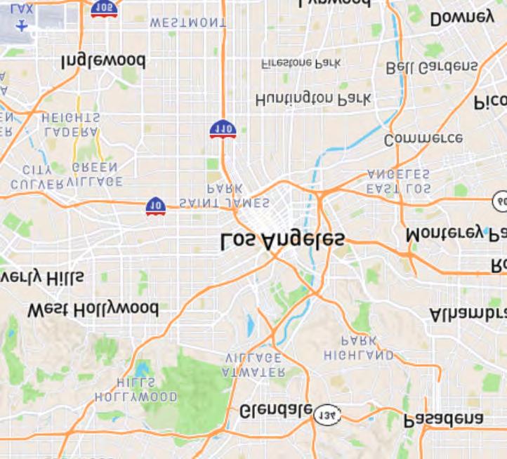
11 September 2017 Potentially Significant Impact Less Than Significant with Mitigation Incorporated Less Than Significant Impact No Impact e. Involve other changes in the existing environment which, due to their location or nature, could result in conversion of Farmland, to non agricultural use or conversion of forest land to non forest use? III. AIR QUALITY. Where available, the significance criteria established by the applicable air quality management or air pollution control district may be relied upon to make the following determinations. Would the project: a. Conflict with or obstruct implementation of the applicable air quality plan? b. Violate any air quality standard or contribute substantially to an existing or projected air quality violation? c. Result in a cumulatively considerable net increase of any criteria pollutant for which the project region is non attainment under an applicable federal or state ambient air quality standard (including releasing emissions which exceed quantitative thresholds for ozone precursors)? d. Expose sensitive receptors to substantial pollutant concentrations? e. Create objectionable odors affecting a substantial number of people? IV. BIOLOGICAL RESOURCES. Would the project: a. Have a substantial adverse effect, either directly or through habitat modifications, on any species identified as a candidate, sensitive, or special status species in local or regional plans, policies, or regulations, or by the California Department of Fish and Game or U.S. Fish and Wildlife Service? b. Have a substantial adverse effect on any riparian habitat or other sensitive natural community identified in local or regional plans, policies, regulations or by the California of Fish and Game or U.S. Fish and Wildlife Service? c. Have a substantial adverse effect on federally protected wetlands as defined by Section 404 of the Clean Water Act (including, but not limited to, marsh vernal pool, coastal, etc.) through direct removal, filling, hydrological interruption, or other means? d. Interfere substantially with the movement of any native resident or migratory fish or wildlife species or with established native resident or migratory wildlife corridors, or impede the use of native wildlife nursery sites? IS-7
12 September 2017 Potentially Significant Impact Less Than Significant with Mitigation Incorporated Less Than Significant Impact No Impact e. Conflict with any local policies or ordinances protecting biological resources, such as tree preservation policy or ordinance? f. Conflict with the provisions of an adopted Habitat Conservation Plan, Natural Community Conservation Plan, or other approved local, regional, or state habitat conservation plan? V. CULTURAL RESOURCES: Would the project: a. Cause a substantial adverse change in the significance of a historical resource as defined in ? b. Cause a substantial adverse change in the significance of an archaeological resource pursuant to ? c. Directly or indirectly destroy a unique paleontological resource or site or unique geologic feature? d. Disturb any human remains, including those interred outside of formal cemeteries? VI. GEOLOGY AND SOILS. Would the project: a. Expose people or structures to potential substantial adverse effects, including the risk of loss, injury, or death involving: i. Rupture of a known earthquake fault, as delineated on the most recent Alquist Priolo Earthquake Fault Zoning Map issued by the State Geologist for the area or based on other substantial evidence of a known fault? Refer to Division of Mines and Geology Special Publication 42. ii. Strong seismic ground shaking? iii. Seismic related ground failure, including liquefaction? iv. Landslides? b. Result in substantial soil erosion or the loss of topsoil? c. Be located on a geologic unit or soil that is unstable, or that would become unstable as a result of the project, and potential result in on or off site landslide, lateral spreading, subsidence, liquefaction or collapse? d. Be located on expansive soil, as defined in Table 18 1 B of the Uniform Building Code (1994), creating substantial risks to life or property? e. Have soils incapable of adequately supporting the use of septic tanks or alternative waste water disposal systems where sewers are not available for the disposal of waste water? IS-8
13 September 2017 Potentially Significant Impact Less Than Significant with Mitigation Incorporated Less Than Significant Impact No Impact VII. GREENHOUSE GAS EMISSIONS. Would the project: a. Generate greenhouse gas emissions, either directly or indirectly, that may have a significant impact on the environment? b. Conflict with an applicable plan, policy or regulation adopted for the purpose of reducing the emissions of greenhouse gases? VIII. HAZARDS AND HAZARDOUS MATERIALS. Would the project: a. Create a significant hazard to the public or the environment through the routine transport, use, or disposal of hazardous materials? b. Create a significant hazard to the public or the environment through reasonably foreseeable upset and accident conditions involving the release of hazardous materials into the environment? c. Emit hazardous emissions or handle hazardous or acutely hazardous materials, substances, or waste within one quarter mile of an existing or proposed school? d. Be located on a site which is included on a list of hazardous materials sites compiled pursuant to Government Code Section and, as a result, would it create a significant hazard to the public or the environment? e. For a project located within an airport land use plan or, where such a plan has not been adopted, within two miles of a public airport or public use airport, would the project result in a safety hazard for people residing or working in the project area? f. For a project within the vicinity of a private airstrip, would the project result in a safety hazard for people residing or working in the project area? g. Impair implementation of or physically interfere with an adopted emergency response plan or emergency evacuation plan? h. Expose people or structures to a significant risk of loss, injury or death involving wildland fires, including where wildlands are adjacent to urbanized areas or where residences are intermixed with wildlands? IX. HYDROLOGY AND WATER QUALITY. Would the project: IS-9
14 September 2017 Potentially Significant Impact Less Than Significant with Mitigation Incorporated Less Than Significant Impact No Impact a. Violate any water quality standards or waste discharge requirements? b. Substantially deplete groundwater supplies or interfere substantially with groundwater recharge such that there would be a net deficit in aquifer volume or a lowering of the local groundwater table level (e.g., the production rate of preexisting nearby wells would drop to a level which would not support existing land uses or planned land uses for which permits have been granted)? c. Substantially alter the existing drainage pattern of the site or area, including through the alteration of the course of a stream or river, in a manner which would result in substantial erosion or siltation on or off site? d. Substantially alter the existing drainage pattern of the site or area, including through the alteration of the course of a stream or river, or substantially increase the rate or amount of surface runoff in an manner which would result in flooding on or off site? e. Create or contribute runoff water which would exceed the capacity of existing or planned stormwater drainage systems or provide substantial additional sources of polluted runoff? f. Otherwise substantially degrade water quality? g. Place housing within a 100 year flood hazard area as mapped on federal Flood Hazard Boundary or Flood Insurance Rate Map or other flood hazard delineation map? h. Place within a 100 year flood hazard area structures which would impede or redirect flood flows? i. Expose people or structures to a significant risk of loss, injury or death involving flooding, including flooding as a result of the failure of a levee or dam? j. Inundation by seiche, tsunami, or mudflow? X. LAND USE AND PLANNING. Would the project: a. Physically divide an established community? b. Conflict with any applicable land use plan, policy, or regulation of an agency with jurisdiction over the project (including, but not limited to the general plan, specific plan, local coastal program, or zoning ordinance) adopted for the purpose of avoiding or mitigating an environmental effect? c. Conflict with any applicable habitat conservation plan or natural community conservation plan? IS-10
15 September 2017 Potentially Significant Impact Less Than Significant with Mitigation Incorporated Less Than Significant Impact No Impact XI. MINERAL RESOURCES. Would the project: a. Result in the loss of availability of a known mineral resource that would be of value to the region and the residents of the state? b. Result in the loss of availability of a locally important mineral resource recovery site delineated on a local general plan, specific plan or other land use plan? XII. NOISE. Would the project result in: a. Exposure of persons to or generation of noise levels in excess of standards established in the local general plan or noise ordinance, or applicable standards of other agencies? b. Exposure of persons to or generation of excessive groundborne vibration or groundborne noise levels? c. A substantial permanent increase in ambient noise levels in the project vicinity above levels existing without the project? d. A substantial temporary or periodic increase in ambient noise levels in the project vicinity above levels existing without the project? e. For a project located within an airport land use plan or, where such a plan has not been adopted, within two miles of a public airport or public use airport, would the project expose people residing or working in the project area to excessive noise levels? f. For a project within the vicinity of a private airstrip, would the project expose people residing or working in the project area to excessive noise levels? XIII. POPULATION AND HOUSING. Would the project: a. Induce substantial population growth in an area either directly (for example, by proposing new homes and businesses) or indirectly (for example, through extension of roads or other infrastructure)? b. Displace substantial numbers of existing housing, necessitating the construction of replacement housing elsewhere? c. Displace substantial numbers of people, necessitating the construction of replacement housing elsewhere? IS-11
16 September 2017 Potentially Significant Impact Less Than Significant with Mitigation Incorporated Less Than Significant Impact No Impact XIV. PUBLIC SERVICES. Would the project result in substantial adverse physical impacts associated with the provision of new or physically altered governmental facilities, need for new or physically altered governmental facilities, the construction of which could cause significant environmental impacts, in order to maintain acceptable service ratios, response times or other performance objectives for any of the public services: a. Fire protection? b. Police protection? c. Schools? d. Parks? e. Other public facilities? XV. RECREATION. a. Would the project increase the use of existing neighborhood and regional parks or other recreational facilities such that substantial physical deterioration of the facility would occur or be accelerated? b. Does the project include recreational facilities or require the construction or expansion of recreational facilities which might have an adverse physical effect on the environment? XVI. TRANSPORTATION/TRAFFIC. Would the project: a. Conflict with an applicable plan, ordinance or policy establishing measures of effectiveness for the performance of the circulation system, taking into account all modes of transportation including mass transit and non motorized travel and relevant components of the circulation system, including but not limited to intersections, streets, highways and freeways, pedestrian and bicycle paths, and mass transit? b. Conflict with an applicable congestion management program, including, but not limited to level of service standards and travel demand measures, or other standards established by the county congestion management agency for designated roads or highways? c. Result in a change in air traffic patterns, including either an increase in traffic levels or a change in location that results in substantial safety risks? d. Substantially increase hazards to a design feature (e.g., sharp curves or dangerous intersections) or incompatible uses (e.g., farm equipment)? IS-12
17 September 2017 Potentially Significant Impact Less Than Significant with Mitigation Incorporated Less Than Significant Impact No Impact e. Result in inadequate emergency access? f. Conflict with adopted policies, plans, or programs regarding public transit, bicycle, or pedestrian facilities, or otherwise decrease the performance or safety of such facilities? XVII. TRIBAL CULTURAL RESOURCES. Would the project cause a substantial adverse change in the significance of a tribal cultural resource, defined in Public Resources Code section as either a site, feature, place, cultural landscape that is geographically defined in terms of the size and scope of the landscape, sacred place, or object with cultural value to a California Native American tribe, and that is: a. Listed or eligible for listing in the California Register of Historical Resources, or in a local register of historical resources as defined in Public Resources Code section (k), or b. A resource determined by the lead agency, in its discretion and supported by substantial evidence, to be significant pursuant to criteria set forth in subdivision (c) of Public Resources Code Section In applying the criteria set forth in subdivision (c) of Public Resource Code Section , the lead agency shall consider the significance of the resource to a California Native American tribe. XVIII. UTILITIES AND SERVICE SYSTEMS. Would the project: a. Exceed wastewater treatment requirements of the applicable Regional Water Quality Control Board? b. Require or result in the construction of new water or wastewater treatment facilities or expansion of existing facilities, the construction of which could cause significant environmental effects? c. Require or result in the construction of new storm water drainage facilities or expansion of existing facilities, the construction of which could cause significant environmental effects? d. Have sufficient water supplies available to serve the project from existing entitlements and resources, or are new or expanded entitlements needed? e. Result in a determination by the wastewater treatment provider which serves or may serve the project that it has adequate capacity to serve the project s projected demand in addition to the provider s existing commitments? IS-13
18 September 2017 Potentially Significant Impact Less Than Significant with Mitigation Incorporated Less Than Significant Impact No Impact f. Be served by a landfill with sufficient permitted capacity to accommodate the project s solid waste disposal needs? g. Comply with federal, state, and local statutes and regulations related to solid waste? XIX. MANDATORY FINDINGS OF SIGNIFICANCE. a. Does the project have the potential to degrade the quality of the environment, substantially reduce the habitat of fish or wildlife species, cause a fish or wildlife population to drop below self sustaining levels, threaten to eliminate a plant or animal community, reduce the number or restrict the range of a rare or endangered plant or animal or eliminate important examples of the major periods of California history or prehistory? b. Does the project have impacts that are individually limited, but cumulatively considerable? ("Cumulatively considerable" means that the incremental effects of an individual project are considerable when viewed in connection with the effects of past projects, the effects of other current projects, and the effects of probable future projects). c. Does the project have environmental effects which will cause substantial adverse effects on human beings, either directly or indirectly? IS-14
19 ATTACHMENT A: PROJECT DESCRIPTION A. INTRODUCTION The (the Project) proposes to develop a mixed use residential and commercial project on an approximately 1.29 acre (56,220 square foot) vacant rectangular site (Project Site) within a larger approximately 7.7 acre property (Unified Development Site). 1 The Unified Development Site includes the entire block bounded by the Harbor Freeway (SR 110) to the west, S. Figueroa Street to the east, W. 7 th Street to the north, and W. 8 th Street to the south. The Unified Development Site contains the Project Site and an existing 13 story parking structure (commercial parking structure) 2 located immediately west of the Project Site, as well as a number of office, retail, and restaurant uses immediately east of the Project Site, including the FIGat7th retail shopping center (FIGat7th shopping center). The Unified Development Site is located in the west central portion of the Downtown community of the (City), which falls within the Financial District of the Central City Community Plan Area. The Unified Development Site is in a highly urbanized and active area in proximity to LA Live, Staples Center, and the Los Angeles Convention Center. The Project Site is currently undeveloped with the exception of an existing covered pedestrian walkway connecting the existing commercial parking structure and commercial retail and office uses to the east and associated ornamental landscaping. The proposed Project would include up to 791,843 square feet of floor area in a single tower atop an 11 level below, at, and above grade podium (Podium), with a maximum building height of 64 stories (approximately 695 feet) above grade as viewed from W. 8 th Street. 3 The Project would include a total of up to 781 residential units and up to approximately 6,700 square feet of commercial retail and/or restaurant uses. Commercial uses would be located at ground level at the Level B1 Plaza level (Level B1 Plaza) adjacent to and connecting with the existing outdoor plaza immediately to the east within the FIGat7th shopping center. Parking would be provided on site within the Podium with vehicular access provided from both W. 8 th Street and from W. 7 th Street. 1 Unified Development is a term used in the Conditional Use Permit entitlement that allows the averaging or the transfer of excess floor area from one or more lots to another lot that meets the definition of a Unified Development. Pursuant to the Los Angeles Municipal Code (LAMC) W.19, Floor Area Ratio Averaging and Residential Density Transfer in Unified Developments (Amended by Ord. No. 182,451, Eff. 4/4/13), a Unified Development is a development comprised of a combination of functional linkages, such as pedestrian or vehicular connections; which is in conjunction with common architectural and landscape features, which constitute distinctive design elements of the development; which is composed of two or more contiguous parcels, or lots of record separated only by a street or alley; and when the development is viewed from adjoining streets appears to be a consolidated whole. 2 The existing commercial parking structure includes one at grade level, nine above grade levels, and three subterranean levels fronting along W. 8 th Street. 3 Unless otherwise indicated, Project floor area numbers used throughout this chapter are calculated in accordance with Los Angeles Municipal Code Section A 1
20 Attachment A: Project Description September 2017 B. PROJECT LOCATION AND SURROUNDING USES The Project Site is located at 945 W. 8 th Street, while the larger Unified Development Site also includes the remainder of the block bounded by SR 110, W. 7 th Street, S. Figueroa Street, and W. 8 th Street. 4 The Project Site is located within the Financial District and near the Los Angeles Sports and Entertainment District (LASED) and Convention Center within the Central City Community Plan Area in Downtown Los Angeles. As shown in Figure A 1, Regional and Site Location Map, the Unified Development Site is served by a network of regional transportation facilities that provide access to the greater metropolitan area. Regional access to the Unified Development Site is provided by the Pasadena/Harbor Freeway (SR 110), located approximately 200 feet to the west; the Santa Monica Freeway (I 10) located approximately 1.0 mile to the south southwest; and the Hollywood Freeway (US 101), located approximately 1.1 miles to the north northeast. These three freeways also provide access to the Golden State/Santa Ana Freeway (I 5), the San Bernardino Freeway (I 10), and the Pomona Freeway (SR 60) to the east of the Downtown area. The Unified Development Site is located across the street and southwest of the 7 th Street/Metro Center Station operated by the Los Angeles County Metropolitan Transportation Authority (Metro)which serves the Red Line and Purple Line subway lines, as well as the Blue Line and Expo Line light rail lines. The Unified Development Site is also served by multiple bus and shuttle lines, including multiple Metro bus lines and the DASH Downtown Shuttle Route. The Unified Development Site is located in a regional center which serves as a commercial center for Los Angeles and the surrounding communities, and as an entertainment center of regional importance that is a popular destination for visitors, local workers and area residents. The Project Site vicinity is characterized by a mix of commercial, restaurant, bar, office, entertainment, and residential uses, as indicated in Figure A 2, Aerial Photograph, below. In addition, Figure A 3, Unified Development Site, also below, illustrates the Project Site s location within the overall Unified Development Site, as well as those land uses immediately surrounding the Unified Development Site. As shown in Figures A 2 and A 3, on site uses surrounding the Project Site include: the adjacent FIGat7th shopping center, Ernst & Young Tower, 777 Tower, and two low rise retail buildings immediately to the east, the adjacent 13 level commercial parking structure with one at grade level, 9 above grade levels and 3 subterranean levels immediately to the west, W. 8 th Street immediately to the south, and W. 7 th Street immediately to the north. Off site land uses farther to the east across S. Figueroa Street include commercial retail, restaurant, office, and residential uses as well as surface and structured parking, while uses to the west beyond the Harbor Freeway include mid rise multi family residential uses and mid to high rise commercial and office uses. 4 The Unified Development Site includes the following addresses: 945 W. 8th St.; 925 & 1013 W. 8th St.; 701, 705, 707, 709, 711, 725, 735, 775, & 777 S. Figueroa St.; and 906, 914 & 920 W. 7th Street. A 2


21 Project Site Path: U:\GIS\GIS\Projects\17xxxx\D170007_755_Figueroa\03_MXDs_Projects\ Project Description\Fig A-1 - Regional Location and Vicinity Map - 8x mxd, dkaneshiro 8/3/2017 N Feet Project Site Unified Development Site SOURCE: Open Street Map, W. 8th Street Project Figure A-1 Regional Location and Vicinity Map


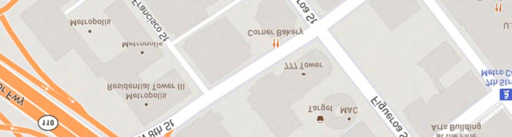
22 Wilshire Grand Center Wedbush Center Path: U:\GIS\GIS\Projects\17xxxx\D170007_755_Figueroa\03_MXDs_Projects\ Project Description\Fig A-2 - Aerial Photograph and Surrounding Land Uses - 8x mxd, dkaneshiro 8/3/2017 Mixed-Use Multi-family Residential and Commercial Metropolis (Under Construction) N SR-110 Freeway FIG at 7th Parking Structure Commercial Parking Feet 801 S. Figueroa Office Tower 777 Tower FIG at 7th Shopping Center Public Parking Ernst & Young Tower Project Site Unified Development Site SOURCE: Google Earth, (Aerial). 945 W. 8th Street Project Figure A-2 Aerial Photograph and Surrounding Land Uses
23 D N Feet SOURCE:, W. 8th Street Project Figure A-3 Unified Development Site
24 Attachment A: Project Description September 2017 To the north across W. 7 th Street are commercial office uses in the mid rise Wedbush Center building as well as commercial retail, office, and luxury hotel uses within the new 1,100 foot tall Wilshire Grand Center building. Land uses to the south across W. 8 th Street include commercial office, retail, and restaurant uses within the high rise tower at 801 S. Figueroa Street a multi level parking structure at the southeast corner of W. 8 th Street and Francisco Street, and residential, retail, restaurant, and hotel uses within several high rise structures as part of the new Metropolis development at the southwest corner of W. 8 th Street and Francisco Street. The Project Site bisects Francisco Street, which forms a T intersection at both W. 7 th Street and W. 8 th Street on the north and south ends, respectively, of the Project Site. 5 C. SITE BACKGROUND AND EXISTING SITE CONDITIONS 1. Project Background and Site History a. CRA Owner Participation Agreement, September 30, 1981 The Unified Development Site is designated as Phase III of an Owner Participation Agreement (OPA) between the previous Community Redevelopment Agency (CRA) of the and Oxford Properties Inc., dated September 30, 1981 for Citicorp Plaza. This is a three phased development bounded by S. Figueroa Street on the east, W. 7 th Street on the north, W. 8 th Street on the south and the I 110 Freeway on the west. The first phase was completed in 1985 consisting of an approximately 900,000 square foot office tower (Ernst & Young Tower), a 350,000 square foot three level FIGat7th shopping center including two department stores and a 1,500 space parking garage (commercial parking structure). The second phase, completed in 1992, consisted of an approximately 1,000,000 square foot office building (777 Tower) and an additional 1,000 parking spaces added to the commercial parking structure. The final phase was intended to consist of a third office building, additional retail space, and parking. Citicorp Plaza received a floor area Variation from the CRA in 1981 (Resolution 1958, dated September 24, 1981) to permit an increase in allowable floor area from 6:1 to 9.5:1 over the entire site and in exchange for the floor area Variation approval, an open space fee of $5,000,000 was paid to the CRA. The funds were used for the acquisition and development/improvement of Grand Hope Park. Subsequent Implementation Agreements and amendments to the OPA indicate that the remaining floor area available for Phase III construction on the Unified Development Site (Lots 3, 9 and 10, see Figure A 3 above) is 791,843 square feet. Both the Third Implementation Agreement, Phase III Uses (Page 4, XI. S 110) and the Fourth Implementation Agreement, Phase III Uses (Page 4, VII. S 106) indicate that the CRA/LA recognizes that market conditions continue to dictate that alternative uses to the previously entitled office use, such as residential, be analyzed and considered on a periodic basis. As such, the Third and Fourth Implementation Agreements allow residential uses to be developed on the Unified Development Site (in addition to residential uses also being allowable under the underlying C2 4D zoning designation). The Project Site is ground Lot 3 with 56,220 square feet of lot area. Lot 10 is an airspace lot located on the top of an existing vacant retail space fronting W. 8 th Street and adjacent to the east of the Project Site with 17,693 5 The Project Site does not actually abut W. 7 th Street; the existing 13 level commercial parking structure s W. 7 th Street access driveway currently separates the Project Site and W. 7 th Street. A 6
25 September 2017 Attachment A: Project Description square feet of site area, while Lot 9 is an airspace lot located on the top of the adjacent 13 level commercial parking structure to the west of the Project Site with 70,162 square feet of site area. b. Department of City Planning Zone Variance Approval, May 29, 1984 A variance from the provisions of the zoning regulations regarding Floor Area Ratio for the entire Citicorp Plaza retail commercial/office complex was granted by the Department of City Planning on May 29, This zone variance approval allowed for the entire Citicorp Plaza site not to exceed a 9.5:1 floor area ratio and the Phase II and Phase III developments to observe respective floor area ratios of 35:1 and 20:1, in lieu of the 13:1 permitted. On March 24, 2010, the Department of City Planning issued a determination confirming that the 945 W. 8 th Street property owner is entitled to the Transfer of Floor Area previously approved by the CRA/LA (i.e., up to 791,843 square feet), in accordance with Resolution 1958 dated September 24, 1981 (Variation from floor area limits) Existing Site Conditions The Project Site is currently undeveloped, with the exception of a paved walkway (and associated shade structure) that traverses the property and provides a pedestrian connection between the existing commercial parking structure immediately to the west with the existing FIGat7th shopping center immediately to the east. A retaining wall, ornamental landscaping, and limited stormwater drainage facilities also occur on the Project Site. Existing landscaping within the Project Site is limited to ornamental landscaping including shrubs and other ground cover within slope areas on site, sixteen (16) Indian Laurel Fig trees (Ficus microcarpa nitida) along the Project Site s W. 8 th Street frontage, four (4) Silver Dollar Eucalyptus trees (Eucalyptus polyanthemos), as well as a row of Italian cypress trees along the on site pedestrian walkway and several other smaller ornamental trees located within the Project Site. 7 D. EXISTING PLANNING AND ZONING The Unified Development Site is zoned C2 4D with a land use designation of Regional Center Commercial in the Central City Community Plan. The C2 zone is a general commercial zone, which is consistent with its Regional Center Commercial land use designation. Typical uses in the C2 zone include retail and commercial uses such as office buildings, retail stores, hotels, restaurants and associated parking. The C2 zone also allows for mixed use buildings, such as buildings with residential units over retail and parking. The Unified 6 Community Redevelopment Agency of the. Citicorp Plaza Fourth Implementation Agreement (Phase III). August 19, Exhibit A: Letter Dated March 24, Lisa Smith, The Tree Resource. Tree Report Prepared for Brookfield Property Partners 601 S. Figueroa Suite 2200 Los Angeles, California Property: 755 S. Figueroa St. (945 W. 8th Street) Los Angeles, CA June 6, This document is included as Appendix A of this Initial Study. A 7
26 Attachment A: Project Description September 2017 Development Site is surrounded by C2 4D zoned properties, which are developed with commercial, residential, and mixed use buildings, as well as parking structures. The Unified Development Site is located in Height District 4, which permits a floor area ratio (FAR) of up to 13:1, or thirteen times the buildable area of the site; however, the D Limitation, enacted by Ordinance 164,307 (Subarea 1930), effective January 30, 1989, limits new development on the site to a total floor area ratio (FAR) of 6:1 (with certain exceptions). The Unified Development Site is not subject to this 6:1 FAR limitation because the Citicorp Plaza development received a floor area Variation from the CRA in 1981 to permit an increase in allowable floor area from 6:1 to 9.5:1, as described above. It should be noted that the City is currently updating the Central City Community Plan. The Unified Development Site is designated as a Transit Core area in the draft land use designation maps. 8 The maximum FAR in the Transit Core is 13:1. Transit core areas are considered dense centers of activity built around regional transit hubs that provide easy access for pedestrians, transit users, and cyclists to a variety of experiences and activities. The general uses emphasized for the Transit Core are mixed use, multi family, residential, entertainment, and office. E. PROJECT DESCRIPTION 1. Development Summary The Project would construct a new mixed use residential and commercial development. Overall proposed uses are summarized in Table A 1, Proposed Development Program. As indicated in Table A 1the Project would include up to 791,843 square feet of floor area (approximately 13:1 FAR) in a single Residential Tower (Residential Tower) that includes the 11 level Podium structure. The Podium would include two completely subterranean levels, three partially subterranean levels (above grade as viewed from W. 8 th Street and below grade relative to W. 7 th Street), and six above grade levels. The Podium would also include commercial uses, active uses, residential uses additional to the parking. The Residential Tower would be located atop the Podium within the northern portion of the Project Site fronting on W. 7 th Street. The tower would be 61 stories (approximately 655 feet) above grade as viewed from W. 7 th Street including the Podium height, or 64 stories (approximately 695 feet) above grade as viewed from W. 8 th Street. The Project would include a total of up to 781 residential units and up to approximately 6,700 square feet of commercial retail and/or restaurant uses. 9 Commercial uses would be located at ground level relative to the Level B1 Plaza level adjacent to the existing outdoor plaza immediately to the east, which would be incorporated into the Project as common open space. Residential units would be provided within the 51 levels above the Podium, as well as on the outer edge of the Podium along the Project s W. 7 th Street frontage. 8. DTLA 2040 Plan Concept Map. Located at: concept map.html. Accessed June 27, Unless otherwise indicated, Project floor area numbers used throughout this chapter are calculated in accordance with Los Angeles Municipal Code Section Commercial floor area includes 5,500 square feet of interior space and 1,200 square feet of outdoor dining space. A 8
27 September 2017 Attachment A: Project Description The majority of the residential amenities would be provided atop of the Podium (i.e., on Level 7), as well as an approximately 1,000 square foot upper level community room. Open space within the Unified Development Site s existing outdoor plaza would be available as an amenity for the residential users. Bicycle parking/storage areas would be provided at street level along the Project s W. 8 th Street (on Level B3) and on Level B1 fronting the on site outdoor plaza, with pedestrian connections to the Project s W. 7 th Street frontage. Each of the Project s components is described in greater detail below, and are also illustrated below in Figure A 4, Overall Site Plan, Figure A 5, Level B3 (8 th Street), Figure A 6, Level 1 (7 th Street Lobby Level), Figure A 7, Level B1 (Plaza), and Figure A 8, Level 7 (Residential Amenity Level). Table A 1 Proposed Development Program Land Use Residential Studio Units 1 Bedroom Units 2 Bedroom Units 3 Bedroom Units Total Residential Units Residential Unit Floor Area Residential Amenities Total Residential Amenities Total Residential Floor Area Commercial Retail/Restaurant Total Commercial Floor Area Total Building Floor Area Open Space Common Open Space Residential Recreation Space Residential Private Open Space Total Open Space Area Space 208 units 371 units 171 units 31 units 781 units 774,843 sf 10,300 sf 785,143 sf 6,700 sf 6,700 sf 791,843 sf 66,800 sf 10,300 sf 7,600 sf 84,700 sf Notes: sf = square feet Source: PCR and Marmol Radziner, 2017 A 9

28 D N Feet SOURCE: Marmol Radziner, W. 8th Street Project Figure A-4 Overall Site Plan
29 D N 0 64 Feet SOURCE: Marmol Radziner, W. 8th Street Project Figure A-5 Level B3 (8th Street)
30 D N 0 64 Feet SOURCE: Marmol Radziner, W. 8th Street Project Figure A-6 Level 1 (7th Street Lobby Level)

31 D N 0 64 Feet SOURCE: Marmol Radziner, W. 8th Street Project Figure A-7 Level B1 (Plaza)

32 D N 0 64 Feet SOURCE: Marmol Radziner, W. 8th Street Project Figure A-8 Level 7 (Residential Amenity Level)
33 September 2017 Attachment A: Project Description a. Residential Uses and Amenities The Residential Tower would include up to 781 residential units consisting of studios, one bedroom units, two bedroom units, and three bedroom units. Amenities associated with the residential uses include: ground level open space along the Project s W. 7 th Street and W. 8 th Street frontages; the existing outdoor plaza above the FIGat7th shopping center; the Residential Amenity Level on Level 7 (including a pool deck, fitness center, and indoor and outdoor recreational space and common area facilities); as well as a community room for residents on an upper level of the Residential Tower (Upper Amenity Level). b. Podium The proposed Podium would support development of the Residential Tower and associated commercial uses and parking. The Podium would include up to 6,700 square feet of commercial uses located on Level B1 fronting the existing outdoor plaza to the east, and would also include vehicle and bicycle parking. Vehicular parking would be provided within two entirely subterranean levels relative to W. 8 th Street, three partially subterranean levels (above grade as viewed from W. 8 th Street and below grade relative to W. 7 th Street), and six above grade partial parking levels. 10 Bicycle parking for both commercial and residential uses would be provided at street level along the Project s W. 8 th Street (on Level B3) and on Level B1 fronting the on site outdoor plaza, with pedestrian connections to the Project s W. 7 th Street frontage. As discussed above, the Residential Amenity Level top would be located on the Podium Level 7. The above grade Podium levels would be screened using architectural screening, vegetation, or other design features along W. 8 th Street and would be wrapped with residential units along the Project s W. 7 th Street frontage. 2. Project Design and Architecture The Project would incorporate contemporary architecture compatible with the surrounding downtown urban environment. The Project s site plan is focused on integration with the adjacent streetscape and existing public plaza, with an emphasis on its connection to the neighborhood and pedestrians. The Project s Residential Tower is positioned to activate the existing outdoor plaza to the east of the Unified Development Site and incorporate it into the Project as public open space with direct at grade connections and commercial frontage along the Project s Level B1 Plaza level. The commercial component would be located at the base of the Residential Tower lining the western end of the outdoor plaza and the Residential Tower rising to provide a visual edge to the plaza. The Residential Tower would be positioned to optimize the space between the adjacent towers as well as solar access to both the Residential Tower and the plaza. The Residential Amenity Level including a swimming pool and landscaped and hardscaped areas at the top of the Podium would be oriented to capture sunlight and would overlook the outdoor plaza. To facilitate pedestrian access and connectivity through the block and around the neighborhood, a new pedestrian connection is proposed. This would include a small pedestrian plaza on W. 8 th Street as well as a pedestrian stairway connection from W. 8 th Street up to the existing outdoor plaza. The pedestrian walkways would provide direct access to both W. 7 th Street and S. Figueroa Street, continuing northward through the Project Site to W. 7 th Street. This approach is consistent with the Avenue of the Angels concept of connecting 10 Per Los Angeles Municipal Code (LAMC) Section A.4.(i).(3), no vehicular parking is required for commercial spaces of 7,500 square feet or less. However, bicycle parking for commercial uses is still required per LAMC Section 12.21A.16 and Ordinance No. 182,386 even if less than 7,500 square feet in floor area. A 15
34 Attachment A: Project Description September 2017 LA Live to the Financial District through a walkable pedestrian route. This new connection would enable pedestrian circulation from W. 8 th Street up to the plaza level, thereby providing connectivity to transit, retail, and community destinations to the north and east including the Metro station located at W. 7 th Street and S. Figueroa Street, the FIGat7th shopping center, and the new Wilshire Grand tower. The Residential Tower would incorporate balconies and operable windows to create a visual texture within the building façade. The tower would be designed with colors and materials that are compatible with surrounding urban development and would include a mix of low reflectivity glass and solid materials. Building cross sections and elevations of the Project are provided in Figure A 9, Building Cross Sections, while conceptual renderings of the Project are shown in Figure A 10, Conceptual Rendering #1, and Figure A 11, Conceptual Rendering #2, below. 3. Open Space and Landscaping a. Open Space The Project includes 84,700 square feet of open space, which consists of outdoor plaza areas, terraces, a pool deck, gym, community rooms and private residential balcony areas. The proposed open space for the Project is shown in Table A 2, Open Space Summary. The Project would provide public and private open space in accordance with open space requirements. A portion of the common open space would be provided by the existing outdoor plaza, which is a shared space with the on site FIGat7th shopping center, on site office towers, and the general public. This plaza is directly adjacent to the proposed pedestrian walkway along the easterly property line of the proposed Project, as well as the commercial space that is intended as a restaurant/retail use with potential for outdoor dining that may flow out to the Level B1 plaza area to activate the public outdoor space. A 16

35 D Feet SOURCE: Marmol Radziner, W. 8th Street Project Figure A-9 Building Cross Sections

36 D SOURCE: Marmol Radziner, W. 8th Street Project Figure A-10 Conceptual Rendering #1

37 D SOURCE: Marmol Radziner, W. 8th Street Project Figure A-11 Conceptual Rendering #2
APPENDIX M CEQA Initial Study Checklist
 APPENDIX M CEQA Initial Study Checklist Appendix G ENVIRONMENTAL CHECKLIST FORM (To be Completed by Applicant) 1. Project title: 2. Lead agency name and address: 3. Contact person and phone number: 4.
City of Bishop. Environmental Checklist Form
 City of Bishop Environmental Checklist Form 1. Project title: Environmental Review / 2007 California Building Codes 2. Lead agency name and address: City of Bishop 377 W. Line Street Bishop, Ca 93514 3.
Kern County Environmental Checklist Form Environmental Factors Potentially Affected
 Kern County Environmental Checklist Form Environmental Factors Affected The environmental factors checked below would be potentially affected by this project, involving at least one impact that is a potentially
Draft Negative Declaration of Environmental Impact. Project Title: Environmental Review / Tentative Parcel Map No.388
 Draft Negative Declaration of Environmental Date: August 7, 2008 Subject: Condominium Conversion / 287 East Line Street Project Title: Environmental Review / Tentative Parcel Map.388 Project Proponent:
SECTION 9.0 Effects Found Not To Be Significant
 SECTION 9.0 Effects Found Not To Be Significant 9.0 EFFECTS FOUND NOT TO BE SIGNIFICANT The City of Santa Clarita conducted an Initial Study in April 2006 to determine significant effects of the proposed
PROPOSED CALIFORNIA ENVIRONMENTAL QUALITY ACT (CEQA) THRESHOLDS OF SIGNIFICANCE
 THRESHOLDS OF SIGNIFICANCE") CITY OF LOS ANGELES DEPARTMENT OF CITY PLANNING PROPOSED CALIFORNIA ENVIRONMENTAL QUALITY ACT (CEQA) THRESHOLDS OF SIGNIFICANCE The City of Los Angeles Department of City Planning proposes adopting these
CITY OF LOS ANGELES DEPARTMENT OF CITY PLANNING PROPOSED CALIFORNIA ENVIRONMENTAL QUALITY ACT (CEQA) THRESHOLDS OF SIGNIFICANCE The City of Los Angeles Department of City Planning proposes adopting these
CEQA Impact Key Alta East Wind Energy Project DEIR/DEIS
 CEQA Key Project NI = No ; LTS = Less than Sig; SU = Significant and Unavoidable 4.2 Air AR-1 Conflict with or obstruct implementation of the applicable air quality plan 4.3 Climate Change & Greenhouse
RESOLUTION NO. Resolution No. August 19, 2014 Page 1 of 4
 RESOLUTION NO. A RESOLUTION OF THE CITY COUNCIL OF THE CITY OF SIGNAL HILL, CALIFORNIA, APPROVING NEGATIVE DECLARATION 06/20/14(1), RELATIVE TO ZONING ORDINANCE AMENDMENT 14-02, AMENDMENTS TO TITLE 20
CITY OF BISHOP DRAFT 2015 ECONOMIC DEVELOPMENT ELEMENT UPDATE
 A DRAFT NEGATIVE DECLARATION CITY OF BISHOP DRAFT 2015 ECONOMIC DEVELOPMENT ELEMENT UPDATE LEAD AGENCY: City of Bishop 377 West Line Street Bishop, CA 93514 Contact: Gary Schley (760) 873-8458 In accordance
Draft Mitigated Negative Declaration of Environmental Impact. Subject: Proposed Draft Mitigated Negative Declaration of Environmental Impact
 Draft Mitigated Negative Declaration of Environmental Date: June 17, 2007 Subject: Proposed Draft Mitigated Negative Declaration of Environmental Project Title: Environmental Review / Vons Fuel Center
Environmental Checklist Form
 CITY OF ESCONDIDO Planning Division 201 North Broadway Escondido, CA 92025-2798 (760) 839-4671 Environmental Checklist Form 1. Project title: Downtown Marriott Hotel Project 2. Lead agency name and address:
Rocking Horse Ridge II Transfer of Territory
 ENVIRONMENTAL REVIEW FOR: Rocking Horse Ridge II Transfer of Territory Prepared by: ORANGE COUNTY COMMITTEE ON SCHOOL DISTRICT ORGANIZATION Contact: Wendy Benkert, Ed.D Secretary to the County Committee
INSTRUCTIONS ON EVALUATION OF ENVIRONMENTAL IMPACTS
 INSTRUCTIONS ON EVALUATION OF ENVIRONMENTAL IMPACTS 1. A brief explanation is required for all answers except answers that are adequately supported by the information sources a lead agency cites in the
City of Eastvale Zoning Code
 INITIAL STUDY FOR A NEGATIVE DECLARATION FOR THE City of Eastvale Zoning Code Lead Agency: CITY OF EASTVALE 12363 Limonite Avenue, Suite 901 Eastvale, CA 91752 December 9, 2011 NOTICE OF PUBLIC HEARING
CITY OF SAN MATEO Initial Study
 CITY OF SAN MATEO Initial Study 1. Project Title and Number: Suhl Site Development Permit - PA10-015 2. Lead Agency Name and Address: City of San Mateo, Planning Division 330 W. 20th Avenue, San Mateo,
ATTACHMENT A DISCUSSION OF ENVIRONMENTAL FACTORS ARROYO SECO BIKEWAY. a) Have a substantial adverse effect on a scenic vista?
 Have a substantial adverse effect on a scenic vista?") ATTACHMENT A DISCUSSION OF ENVIRONMENTAL FACTORS ARROYO SECO BIKEWAY I. AESTHETICS - Would the proposal: a) Have a substantial adverse effect on a scenic vista? No impact. The proposed project is not within
ATTACHMENT A DISCUSSION OF ENVIRONMENTAL FACTORS ARROYO SECO BIKEWAY I. AESTHETICS - Would the proposal: a) Have a substantial adverse effect on a scenic vista? No impact. The proposed project is not within
Campus Photovoltaic Energy Project at California State University Channel Islands
 Negative Declaration and Initial Study Campus Photovoltaic Energy Project at California State University Channel Islands The Trustees of the California State University Project Proponent: California State
Ruby Maldonado Project Manager, Planning, OC Development Services
 DATE: January 7, 2016 TO: FROM: Ruby Maldonado Project Manager, Planning, OC Development Services Chris Uzo-Diribe, Planning, OC Development Services SUBJECT: IP15-386 - Addendum IP 15-386 to Negative
INITIAL STUDY & ENVIRONMENTAL CHECKLIST
 INITIAL STUDY & ENVIRONMENTAL CHECKLIST Project Title Project Location Project Description Lead Agency Contact Biological Resource Policy Update and Oak Resources Management Plan Project El Dorado County
TABLE OF CONTENTS. Mitigated Negative Declaration Form/CEQA Initial Study Checklist (front insert) I. INTRODUCTION... I-1 PROJECT DESCRIPTION...
 I. INTRODUCTION... I-1 PROJECT DESCRIPTION...") TABLE OF CONTENTS Mitigated Negative Declaration Form/CEQA Initial Study Checklist (front insert) I. INTRODUCTION... I-1 II. PROJECT DESCRIPTION... II-1 A. PROJECT LOCATION... II-1 B. PROJECT CHARACTERISTICS...
TABLE OF CONTENTS Mitigated Negative Declaration Form/CEQA Initial Study Checklist (front insert) I. INTRODUCTION... I-1 II. PROJECT DESCRIPTION... II-1 A. PROJECT LOCATION... II-1 B. PROJECT CHARACTERISTICS...
CITY OF LOS ANGELES OFFICE OF THE CITY CLERK ROOM 615, CITY HALL LOS ANGELES, CALIFORNIA 90012
 CITY OF LOS ANGELES OFFICE OF THE CITY CLERK ROOM 615, CITY HALL LOS ANGELES, CALIFORNIA 90012 CALIFORNIA ENVIRONMENTAL QUALITY ACT INITIAL STUDY AND CHECKLIST (Article IV B City CEQA Guidelines) LEAD
DRAFT INITIAL STUDY/NEGATIVE DECLARATION LEAD AGENCY: CITY OF EL SEGUNDO Planning and Building Safety Department
 DRAFT INITIAL STUDY/NEGATIVE DECLARATION GENERAL PLAN AND ZONE TET AMENDMENT, USES IN THE CORPORATE OFFICE ZONE (EA 1218, GPA 18-01, AND ZTA 18-01) LEAD AGENCY: CITY OF EL SEGUNDO Planning and Building
PROJECT SITE. Figure 1 Regional and Vicinity Map. Regional Location Map. Scale (Feet)
") PROJECT SITE 118 Northridge 5 210 Regional Location Map 101 North 170 Hollywood Burbank Glendale Pasadena Woodland Hills Toluca Lake PROJECT SITE 134 5 2 2 110 210 405 101 Los Angeles 10 10 60 Santa Monica
PROJECT SITE 118 Northridge 5 210 Regional Location Map 101 North 170 Hollywood Burbank Glendale Pasadena Woodland Hills Toluca Lake PROJECT SITE 134 5 2 2 110 210 405 101 Los Angeles 10 10 60 Santa Monica
Proposed Initial Study/Negative Declaration
 Wireless Telecommunication Facilities Ordinance Proposed Initial Study/Negative Declaration Prepared by: City of Calabasas Planning and Community Development Department 100 Civic Center Way Calabasas,
Environmental Checklist Form
 Environmental Checklist Form 1. Project Title: Change of Zone No. 05-07 (Pre-Zone) and Lotus Ranch Vesting Tentative Subdivision Map 2. Lead Agency Name and Address: City of El Centro 1275 Main Street
RELATED CASES: VTT-63479
 LEAD CITY AGENCY: LOS ANGELES DEPARTMENT OF CITY PLANNING RESPONSIBLE AGENCIES: ENVIRONMENTAL CASE: ENV-2005-7196-MND(REC2) PREVIOUS ACTIONS CASE NO.: PROJECT DESCRIPTION: 81-UNIT RESIDENTIAL CONDOMINIUM
CITY OF LOS ANGELES OFFICE OF THE CITY CLERK ROOM 395, CITY HALL LOS ANGELES, CALIFORNIA 90012
 LEAD CITY AGENCY Department of City Planning RESPONSIBLE AGENCIES CITY OF LOS ANGELES OFFICE OF THE CITY CLERK ROOM 395, CITY HALL LOS ANGELES, CALIFORNIA 90012 CALIFORNIA ENVIRONMENTAL QUALITY ACT INITIAL
CITY OF BANNING Initial Study/Negative Declaration
 CITY OF BANNING Initial Study/Negative Declaration General Plan Amendment and Rezoning Related to Regional Housing Needs Assessment City of Banning Community Development Department 99 E. Ramsey Street
INITIAL STUDY AND PROPOSED NEGATIVE DECLARATION FOR THE INYO COUNTY 2015 ACTIVE TRANSPORTATION PLAN
 INITIAL STUDY AND PROPOSED NEGATIVE DECLARATION FOR THE INYO COUNTY 2015 ACTIVE TRANSPORTATION PLAN Prepared for Inyo County Transportation Commission 168 N. Edwards Street Independence, CA 93526 Prepared
CITY OF BISHOP PROPOSED 2012 MOBILITY ELEMENT UPDATE
 DRAFT NEGATIVE DECLARATION CITY OF BISHO ROOSED 2012 MOBILITY ELEMENT UDATE LEAD AGENCY: City of Bishop 377 West Line Street Bishop, CA 93514 Contact: Gary Schley (760) 873-8458 Background, Authority and
COUNTY OF LOS ANGELES
 COUNTY OF LOS ANGELES DEPARTMENT OF PUBLIC WORKS 900 SOUTH FREMONT AVENUE ALHAMBRA, CALIFORNIA 91803-1331 Telephone: (626) 458-5100 JAMES A. NOYES, Director www.ladpw.org ADDRESS ALL CORRESPONDENCE TO:
ENVIRONMENTAL REVIEW PROCESS AND ADOPTION OF MITIGATED NEGATIVE DECLARATION
 CALIFORNIA ENVIRONMENTAL QUALITY ACT FINDINGS IN CONNECTION WITH THE APPROVAL OF LANDELS HILL-BIG CREEK NATURAL RESERVE AT THE UNIVERSITY OF CALIFORNIA, LANDELS HILL-BIG CREEK NATURAL RESERVE I. ENVIRONMENTAL
INITIAL STUDY AND ENVIRONMENTAL REVIEW. Daniel D. Chance, Associate Planner (707) x19
 x19") CITY OF LAKEPORT COMMUNITY DEVELOPMENT DEPARTMENT INITIAL STUDY / ENVIRONMENTAL REVIEW (GPA 16-01,ZC 16-01 and ER 16-01) INITIAL STUDY AND ENVIRONMENTAL REVIEW The application for Amendment of the City
CITY OF LAKEPORT COMMUNITY DEVELOPMENT DEPARTMENT INITIAL STUDY / ENVIRONMENTAL REVIEW (GPA 16-01,ZC 16-01 and ER 16-01) INITIAL STUDY AND ENVIRONMENTAL REVIEW The application for Amendment of the City
ADDENDUM. to the FINAL ENVIRONMENTAL IMPACT REPORT. [State Clearinghouse No ]
![ADDENDUM. to the FINAL ENVIRONMENTAL IMPACT REPORT. [State Clearinghouse No ]](/thumbs/95/123669169.jpg "ADDENDUM. to the FINAL ENVIRONMENTAL IMPACT REPORT. [State Clearinghouse No ]") ADDENDUM to the FINAL ENVIRONMENTAL IMPACT REPORT [State Clearinghouse No. 2012061046] for the AMENDED AND RESTATED ALBERHILL VILLAGES SPECIFIC PLAN and DEVELOPMENT AGREEMENT BETWEEN THE CITY OF LAKE ELSINORE
ADDENDUM to the FINAL ENVIRONMENTAL IMPACT REPORT [State Clearinghouse No. 2012061046] for the AMENDED AND RESTATED ALBERHILL VILLAGES SPECIFIC PLAN and DEVELOPMENT AGREEMENT BETWEEN THE CITY OF LAKE ELSINORE
INITIAL STUDY CHECKLIST AND PROPOSED MITIGATED NEGATIVE DECLARATION
 Attachment A INITIAL STUDY CHECKLIST AND PROPOSED MITIGATED NEGATIVE DECLARATION Downtown Riverfront Streetcar Project July 2015 Sacramento Area Council of Governments 11415 L Street, Suite 300 Sacramento,
INITIAL STUDY/ NEGATIVE DECLARATION
 INITIAL STUDY/ NEGATIVE DECLARATION INITIAL STUDY/ NEGATIVE DECLARATION Project Title: Lead Agency Name and Address: Project Location: Project Sponsor s Name and Address: General Plan Designation(s): Zoning:
The following findings are hereby adopted by The Regents in conjunction with the approval of the Project which is set forth in Section III, below.
 CALIFORNIA ENVIRONMENTAL QUALITY ACT FINDINGS IN CONNECTION WITH THE APPROVAL OF THE EAST CAMPUS STUDENT HOUSING PHASE III DEVELOPMENT PROJECT UNIVERSITY OF CALIFORNIA, IRVINE I. ADOPTION OF THE MITIGATED
APPENDIX A NOP AND COMMENT LETTERS
 APPENDIX A NOP AND COMMENT LETTERS N O T I C E O F P R E P A R A T I O N DATE: December 19, 2005 TO: LEAD AGENCY: SUBJECT: State Clearinghouse, Responsible Agencies, Trustee Agencies, Organizations and
Initial Study Olympic (Olympia) Project. Case Number: ENV EIR
 Project. Case Number: ENV EIR") Initial Study 1001 Olympic (Olympia) Project Case Number: ENV-2016-4889-EIR Project Location: 911-955 South Georgia Street; 1000-1016 West James M. Wood Boulevard; 936-950 South Bixel Street; 1013-1025
Initial Study 1001 Olympic (Olympia) Project Case Number: ENV-2016-4889-EIR Project Location: 911-955 South Georgia Street; 1000-1016 West James M. Wood Boulevard; 936-950 South Bixel Street; 1013-1025
The Village at Corte Madera Expansion Project
 The Village at Corte Madera Expansion Environmental Report Addendum State Clearinghouse Number: 2016102061 Town of Corte Madera 300 Tamalpais Drive Corte Madera, CA 94925 April 2018 The Village at Corte
2018 Kings County Association of Governments RTP/SCS
 2018 Kings County Association of Governments RTP/SCS Initial Study prepared by Kings County Association of Governments 339 West D Street, Suite B Lemoore, California 93245 Contact: Terri King, Executive
City of Temecula Community Development
 December 15, 2011 City of Temecula Community Development Planning Division tice of Preparation And Public Scoping Meeting tice To: Subject: Agencies and Interested Parties tice of Preparation of a Draft
TABLE OF CONTENTS. Mitigated Negative Declaration Form/CEQA Initial Study Checklist (front insert) I. INTRODUCTION... I-1 PROJECT DESCRIPTION...
 I. INTRODUCTION... I-1 PROJECT DESCRIPTION...") TABLE OF CONTENTS Mitigated Negative Declaration Form/CEQA Initial Study Checklist (front insert) I. INTRODUCTION... I-1 II. PROJECT DESCRIPTION... II-1 A. PROJECT LOCATION... II-1 B. PROJECT CHARACTERISTICS...
TABLE OF CONTENTS Mitigated Negative Declaration Form/CEQA Initial Study Checklist (front insert) I. INTRODUCTION... I-1 II. PROJECT DESCRIPTION... II-1 A. PROJECT LOCATION... II-1 B. PROJECT CHARACTERISTICS...
INITIAL STUDY/NOTICE OF PREPARATION ENVIRONMENTAL IMPACT REPORT ORANGE COUNTY WATER DISTRICT PRADO BASIN SEDIMENT MANAGEMENT DEMONSTRATION PROJECT
 INITIAL STUDY/NOTICE OF PREPARATION ENVIRONMENTAL IMPACT REPORT ORANGE COUNTY WATER DISTRICT PRADO BASIN SEDIMENT MANAGEMENT DEMONSTRATION PROJECT Orange County Water District 18700 Ward Street Fountain
CITY OF EL CENTRO PUBLIC REVIEW NOTICE OF INTENT TO ADOPT NEGATIVE DECLARATION NO
 CITY OF EL CENTRO PUBLIC REVIEW NOTICE OF INTENT TO ADOPT NEGATIVE DECLARATION NO. 14-01 tice is hereby given that a Negative Declaration has been prepared for Change of Zone 14-01 & General Plan Amendment
5.0 LONG-TERM CEQA CONSIDERATIONS
 5.0 LONG-TERM CEQA CONSIDERATIONS Section 15126 of the CEQA Guidelines requires that all phases of a project must be considered when evaluating its impact on the environment, including planning, acquisition,
INITIAL STUDY ENVIRONMENTAL CHECKLIST FORM
 DEPARTMENT OF PUBLIC WORKS AND PLANNING STEVEN E. WHITE, DIRECTOR INITIAL STUDY ENVIRONMENTAL CHECKLIST FORM 1. Project title: Initial Study No. 7420 and Unclassified Conditional Use Permit No. 3599 2.
APPENDIX A INITIAL STUDY
 City of Los Angeles May 2009 APPENDIX A INITIAL STUDY Draft Environmental Impact Report Technical Appendices Environmental Review Section City Hall 200 N. Spring Street, Room 750 Los Angeles, CA 90012
CITY OF SAN GABRIEL ENVIRONMENTAL CHECKLIST FORM
 CITY OF SAN GABRIEL ENVIRONMENTAL CHECKLIST FORM 1. Project title: Greening the Code (Planning Case. PL-13-034) 2. Lead agency name and address: City of San Gabriel, 425 S. Mission Drive, San Gabriel,
Addendum No. 7 to the EIR
 Addendum No. 7 to the EIR San Bernardino County Transportation Authority Redlands Passenger Rail Project SCH No. 2012041012 January 30, 2019 This page is intentionally blank. Contents 1 Purpose and Background...
WHITTIER NARROWS WATER RECLAMATION PLANT DIVERSION
 Draft WHITTIER NARROWS WATER RECLAMATION PLANT DIVERSION Initial Study Prepared for July 2018 Sanitation Districts of Los Angeles County Draft WHITTIER NARROWS WATER RECLAMATION PLANT DIVERSION Initial
CEDARS-SINAI MEDICAL CENTER WEST TOWER PROJECT ENV EIR APPENDIX A NOTICE OF PREPARATION INITIAL STUDY PUBLIC SCOPING COMMENTS
 CEDARS-SINAI MEDICAL CENTER WEST TOWER PROJECT ENV 2008-0620-EIR APPENDIX A NOTICE OF PREPARATION INITIAL STUDY PUBLIC SCOPING COMMENTS CEDARS-SINAI MEDICAL CENTER WEST TOWER PROJECT ENV 2008-0620-EIR
ENV MND Page 1 of 22
 LEAD CITY AGENCY City of Los Angeles PROJECT TITLE ENV-2012-1361-MND PROJECT LOCATION 20600 W ROSCOE BLVD CITY OF LOS ANGELES OFFICE OF THE CITY CLERK ROOM 395, CITY HALL LOS ANGELES, CALIFORNIA 90012
NEGATIVE DECLARATION. Document Released
 NEGATIVE DECLARATION Pursuant to Division 6, Title 14, Chapter 3, Article 6, Sections 15070 and 15071 of the California Administrative Code and pursuant to the Procedures for Preparation and Processing
MARCH 29, 2016 GGRO007
 INITIAL STUDY AND MITIGATED NEGATIVE DECLARATION CONDITIONAL USE PERMIT (CUP) NO. 073-2016 HEAVEN S GATE FUNERAL HOME 13272 GARDEN GROVE BOULEVARD GARDEN GROVE, CALIFORNIA LEAD AGENCY: CITY OF GARDEN GROVE
County o Fresno is Times New DRADRAFT NOTICE OF DETERMINATION
 County o Fresno is Times New DRADRAFT NOTICE OF DETERMINATION DEPARTMENT OF PUBLIC WORKS AND PLANNING STEVEN E. WHITE, DIRECTOR To: Office of Planning and Research County Clerk, County of Fresno 1400 Tenth
City of Santa Monica Santa Monica Single-use Carryout Bag Ordinance. Initial Study
 Santa Monica Single-use Carryout Bag Ordinance March 2010 Santa Monica Single-use Carryout Bag Ordinance Prepared by: Office of Sustainability and the Environment 200 Santa Monica Pier, Suite D Santa Monica,
Environmental Initial Study Parks Master Plan City of La Mesa, County of San Diego, CA
 Environmental Initial Study Parks Master Plan City of La Mesa, County of San Diego, CA Lead Agency: City of La Mesa 4975 Memorial Drive La Mesa, CA 91942 619-667-1308 Contact: Mike Pacheco, Project Manager
IV. ENVIRONMENTAL IMPACT ANALYSIS G. HYDROLOGY/WATER QUALITY
 IV. ENVIRONMENTAL IMPACT ANALYSIS G. HYDROLOGY/WATER QUALITY ENVIRONMENTAL SETTING The project site is located in the Wilshire community of the City of Los Angeles and is bound by S. Wetherly Drive to
North Reseda Boulevard Project CPC ZC-CU-ZAD-SPR ENV MND VTT-73641
 City of Los Angeles Department of City Planning Environmental Review Section City Hall 200 N. Spring Street, Room 763 Los Angeles, CA 90012 INITIAL STUDY MITIGATED NEGATIVE DECLARATION Northridge Community
Appendix A. Initial Study/NOP/NOP Comment Letters
 Appendix A Initial Study/NOP/NOP Comment Letters VERMONT AVE Source: Matrix Environmental, 2009; Rand McNally-Thomas Guide Digital California Edition. HOOVER ST N USC Specific Plan / NOP USC Project
EL DORADO COUNTY PLANNING SERVICES 2850 FAIRLANE COURT PLACERVILLE, CA ENVIRONMENTAL CHECKLIST FORM AND DISCUSSION OF IMPACTS
 Project Title: COC05-0164 EL DORADO COUNTY PLANNING SERVICES 2850 FAIRLANE COURT PLACERVILLE, CA 95667 ENVIRONMENTAL CHECKLIST FORM AND DISCUSSION OF IMPACTS Lead Agency Name and Address: El Dorado County,
City of Los Angeles Reseda Boulevard Mixed-Use Project. Initial Study
 City of Los Angeles Reseda Boulevard Mixed-Use Project Initial Study November 2016 Reseda Boulevard Mixed-Use Project Initial Study Prepared for: City of Los Angeles 200 North Spring Street, Suite 750
Mitigated Negative Declaration and Initial Study Student Residence Hall
 Mitigated Negative Declaration and Initial Study Student Residence Hall California State University, Sacramento July 2014 Mitigated Negative Declaration Student Residence Hall California State University,
Kress Project Environmental Initial Study and Mitigated Negative Declaration. For: Design Review, Conditional Use Permit, and Lot Line Adjustment
 Kress Project Environmental Initial Study and Mitigated Negative Declaration For: Design Review, Conditional Use Permit, and Lot Line Adjustment Owner: David and Collette Kress Saratoga, CA 95070 Public
Mitigated Negative Declaration. MacArthur Pump Station Rehabilitation Project. Newport Beach, California. Orange County Sanitation District
 Mitigated Negative Declaration MacArthur Pump Station Rehabilitation Project Newport Beach, California Prepared for Orange County Sanitation District Prepared by January 2015 Initial Study MacArthur
November 2006 NOP and IS
 November 2006 NOP and IS NOTICE OF PREPARATION TO: Distribution List (Attached) Lead Agency: Consulting Firm: Agency Name: City of Santa Clarita Name: Sciences Street 23920 Valencia Boulevard, Street Address:
Carpinteria Valley Water District Carpinteria Advanced Purification Project
 NOTICE OF PREPARATION AND SCOPING MEETING Carpinteria Valley Water District Carpinteria Advanced Purification Project TO: Agencies, Organizations, and Interested Parties DATE: January 7, 2019 SUBJECT:
FINAL MITIGATED NEGATIVE DECLARATION
 (310) 253-5710 FAX (310) 253-5721 9770 CULVER BOULEVARD, CULVER CITY, CALIFORNIA 90232-0507 FINAL MITIGATED NEGATIVE DECLARATION Project Title and Culver City File No.: Ivy Station Transit Oriented Mixed
General Plan Housing Element 5 th Cycle Update
 General Plan Housing Element 5 th Cycle Update Initial Study Negative Declaration December 2014 INITIAL STUDY GENERAL PLAN HOUSING ELEMENT 5 TH CYCLE UPDATE Prepared for 100 Civic Center Plaza Lompoc,
YOLO COUNTY COMMUNITY SERVICES DEPARTMENT INITIAL STUDY/NEGATIVE DECLARATION
 YOLO COUNTY COMMUNITY SERVICES DEPARTMENT INITIAL STUDY/NEGATIVE DECLARATION RAVINE SPORTS BAR & GRILL USE PERMIT ZONE FILE # 2017-0074 vember 2017 Initial Environmental Study 1. Project Title: Zone File
Academy Square Project Case No. ENV EIR. Council District No. 13
 Major Projects & EIR Section City Hall 200 N. Spring Street, Room 750 Los Angeles, CA 90012 INITIAL STUDY HOLLYWOOD COMMUNITY PLAN AREA Case No. ENV- 2014-2735- EIR Council District No. 13 THIS DOCUMENT
BRISTOL STREET CORRIDOR SPECIFIC PLAN & GENERAL PLAN AMENDMENT
 BRISTOL STREET CORRIDOR SPECIFIC PLAN & GENERAL PLAN AMENDMENT ADDENDUM TO THE FINAL BRISTOL STREET CORRIDOR SPECIFIC PLAN EIR State Clearinghouse No. 87101404 Prepared for: City of Santa Ana 20 Civic
Initial Study and Proposed Negative Declaration for the Alpine County 2010 Regional Transportation Plan
 Initial Study and Proposed Negative Declaration for the Alpine County 2010 Regional Transportation Plan Prepared for the Alpine County Local Transportation Commission Prepared by TRANSPORTATION CONSULTANTS,
Proposed Mitigated Negative Declaration. Yorba Linda Pump Station Abandonment Project. Fullerton, California. Orange County Sanitation District
 Proposed Mitigated Negative Declaration Yorba Linda Pump Station Abandonment Project Fullerton, California Prepared for Orange County Sanitation District Prepared by December 2014 Initial Study Yorba
INITIAL STUDY ANDADDENDUM TO THE 2006 TRANSBAY CABLE PROJECT EIR
 INITIAL STUDY ANDADDENDUM TO THE 2006 TRANSBAY CABLE PROJECT EIR MAY 2013 PREPARED FOR: CITY OF PITTSBURG 65 CIVIC AVENUE PITTSBURG, CA 94565 PREPARED BY: JOAN LAMPHIER CONSULTING PLANNER JML PLANNING
MAMMOTH COMMUNITY WATER DISTRICT Initial Study/Mitigated Negative Declaration
 MAMMOTH COMMUNITY WATER DISTRICT Initial Study/Mitigated Negative Declaration Pursuant to the California Environmental Quality Act and CEQA Guidelines, the Mammoth Community Water District proposes to
APPENDIX A. Notice of Preparation (NOP) and Initial Study
 and Initial Study") APPENDIX A Notice of Preparation (NOP) and Initial Study SANTA MONICA COLLEGE CALIFORNIA ENVIRONMENTAL QUALITY ACT (CEQA) INITIAL STUDY CHECKLIST PROJECT TITLE DATE: September 22, 2009 LEAD AGENCY:
APPENDIX A Notice of Preparation (NOP) and Initial Study SANTA MONICA COLLEGE CALIFORNIA ENVIRONMENTAL QUALITY ACT (CEQA) INITIAL STUDY CHECKLIST PROJECT TITLE DATE: September 22, 2009 LEAD AGENCY:
1.0 INTRODUCTION A. PURPOSE OF THE DRAFT EIR 1-1
 1.0 INTRODUCTION This Draft Environmental Impact Report (Draft EIR or EIR) has been prepared for the 1020 S. Figueroa Street Project (the Project). Jia Yuan USA Co., Inc., the Applicant, proposes to develop
RIVERSIDE COUNTY ENVIRONMENTAL ASSESSMENT FORM: INITIAL STUDY
 RIVERSIDE COUNTY ENVIRONMENTAL ASSESSMENT FORM: INITIAL STUDY Environmental Assessment (E.A.) Number: EA38725 Project Case Type (s) and Number(s): CZ6699, PM30525, CUP3378 Lead Agency Name: County of Riverside
The following presents a brief summary of Proposed Project effects found not to be significant, including reasons why they would not be significant.
 VII. EFFECTS FOUND NOT TO BE SIGNIFICANT 1. INTRODUCTION This section of the EIR provides information regarding impacts of the Proposed Project that were determined to be less than significant by the City
Prado Basin Feasibility Study Initial Study/Notice of Preparation Environmental Impact Report/Environmental Impact Statement
 Prado Basin Feasibility Study Initial Study/Notice of Preparation Environmental Impact Report/Environmental Impact Statement Orange County Water District 18700 Ward Street Fountain Valley, CA 92708 Contact:
INITIAL STUDY/MITIGATED NEGATIVE DECLARATION FOR LA SIERRA METROLINK PARKING LOT EXPANSION PROJECT
 INITIAL STUDY/MITIGATED NEGATIVE DECLARATION FOR LA SIERRA METROLINK PARKING LOT EPANSION PROJECT Prepared By: Riverside County Transportation Commission 4080 Lemon Street Riverside, California 92501 March
5. OTHER CEQA CONSIDERATIONS
 5. OTHER CEQA CONSIDERATIONS Cumulative Impacts CEQA requires the analysis of impacts due to cumulative development that would occur independent of, but during the same timeframe as, the project under
CITY OF MALIBU NOTICE OF INTENT TO ADOPT A NEGATIVE DECLARATION
 CITY OF MALIBU NOTICE OF INTENT TO ADOPT A NEGATIVE DECLARATION Notice is hereby given that the City of Malibu has completed an Initial Study for the following project in accordance with the California
2 Executive Summary 2.1 Project Location
 2 Executive Summary 2.1 Project Location Draft Supplemental Environmental Impact Report page 11 2. Executive Summary 2.1 Project Location The proposed Project, known as the Outlets at San Clemente Sign
CITY OF BEVERLY HILLS SOUTH CARSON ROAD REZONE PROJECT INITIAL STUDY
 CITY OF BEVERLY HILLS 128-130 SOUTH CARSON ROAD REZONE PROJECT INITIAL STUDY Table of Contents Initial Study 1. Project title:... 3 2. Lead agency name and address:... 3 3. Contact person and phone number:...
ORDINANCE NO
 ORDINANCE NO. 15-937 AN ORDINANCE OF THE CITY COUNCIL OF THE CITY OF LA PUENTE AMENDING TABLE 2-5 (CM ZONE-ALLOWED USES AND PERMIT REQUIREMENTS) OF SECTION 10.14.020 (LAND USE REGULATIONS) OF CHAPTER 10.14
As noted, the Marblehead EIR included an environmental analysis of a fully operational, approximately 750,000-square-foot regional commercial center,
 Initial Study 1. Project Title: Freeway-Oriented Signage for The Outlets at San Clemente 2. Lead Agency Name and Address: City of San Clemente 100 Avenida Presidio San Clemente, CA 92673 3. Contact Person
Initial Study Gold s Gym Building !! " % & City of Commerce COMM 056 July Page 1
 !! " #$ % & COMM 056 July 2006 Page 1 Section '()*+*,'),' Page,...3 -....13 1.1 Purpose of...14 1.2 Format of...14. /0!...15 2.1 Project Location...16 2.2 Environmental Setting...16 2.3 Physical and Operational
Initial Study/ Negative Declaration for Olympic Boulevard and Mateo Street Improvements (W.O. E )
") MATEO MATEO ST ST MATEO MATEO ST ST MATEO MATEO ST ST MATEO MATEO MATEO ST ST ST SANTA SANTA FE FE AVE AVE SANTA SANTA SANTA FE FE FE AVE AVE AVE MATEO MATEO MATEO ST ST ST MATEO ST ALLEY ALLEY SANTA SANTA
MATEO MATEO ST ST MATEO MATEO ST ST MATEO MATEO ST ST MATEO MATEO MATEO ST ST ST SANTA SANTA FE FE AVE AVE SANTA SANTA SANTA FE FE FE AVE AVE AVE MATEO MATEO MATEO ST ST ST MATEO ST ALLEY ALLEY SANTA SANTA
CEQA Environmental Checklist
 CEQA Environmental Checklist PROJECT DESCRIPTION AND BACKGROUND Project Title: January 2017 Service Changes Lead agency name and address: Sacramento Regional Transit District, P.O. Box 2110, 1400 29 th
CITY OF LOS ANGELES CALIFORNIA ENVIRONMENTAL QUALITY ACT INITIAL STUDY (Article I - City CEQA Guidelines)
") CITY OF LOS ANGELES CALIFORNIA ENVIRONMENTAL QUALITY ACT INITIAL STUDY (Article I - City CEQA Guidelines) Council District: 1,2,3,4,5,6,9,12,13,14 Date: 3/27/2008 Lead City Agency: Project Title: Department
CITY OF LOS ANGELES CALIFORNIA ENVIRONMENTAL QUALITY ACT INITIAL STUDY (Article I - City CEQA Guidelines) Council District: 1,2,3,4,5,6,9,12,13,14 Date: 3/27/2008 Lead City Agency: Project Title: Department
MWS WIRE INDUSTRIES NEW MANUFACTURING WAREHOUSE
 Planning Division 214 South C Street Oxnard, CA 93030 (805) 385-7858 INITIAL STUDY NEGATIVE DECLARATION NO. 18-01 March 21, 2018 MWS WIRE INDUSTRIES NEW MANUFACTURING WAREHOUSE Planning and Zoning Permit
On the basis of this initial evaluation, the Environmental Coordinator finds that:
 COUNTY OF SAN LUIS OBISPO INITIAL STUDY SUMMARY - ENVIRONMENTAL CHECKLIST (ver 2.1) Project Title & No. ALUP Amendment for Paso Robles Airport ED06-299 ENVIRONMENTAL FACTORS POTENTIALLY AFFECTED: The proposed
AGENDA REPORT. LED Streetlight Upgrade Program Initial Study/ Mitigated Negative Declaration
 CITY OF PACIFIC GROVE 300 Forest Avenue, Pacific Grove, California 93950 AGENDA REPORT Agenda. 12A Page 1 of 3 TO: FROM: MEETING DATE: April 18, 2018 SUBJECT: CEQA: Honorable Mayor and Members of City
DRAFT NEGATIVE DECLARATION OF ENVIRONMENTAL IMPACT AND INITIAL STUDY
 Planning Department 168 North Edwards Street Post Office Drawer L Independence, California 93526 Phone: (760) 878-0263 FAX: (760) 878-0382 E-Mail: inyoplanning@ Inyocounty.us DRAFT NEGATIVE DECLARATION
INITIAL STUDY AND ENVIRONMENTAL REVIEW CHECKLIST California Environmental Quality Act (CEQA)
") INITIAL STUDY AND ENVIRONMENTAL REVIEW CHECKLIST California Environmental Quality Act (CEQA) 1. Project Title: Pedestrian Master Plan for Unincorporated Areas 2. Lead Agency Name and Address: County of
INITIAL STUDY AND ENVIRONMENTAL REVIEW CHECKLIST California Environmental Quality Act (CEQA) 1. Project Title: Pedestrian Master Plan for Unincorporated Areas 2. Lead Agency Name and Address: County of
City of Los Angeles. Kaiser Permanente Outpatient Medical Facility - Baldwin Hills MOB Case Number: ENV MND
 City of Los Angeles Department of City Planning Environmental Analysis Section City Hall 200 N. Spring Street, Room 750 Los Angeles, CA 90012 INITIAL STUDY/ MITIGATED NEGATIVE DECLARATION West Adams -
City of Los Angeles INITIAL STUDY. 670 Mesquit Project
 City of Los Angeles Department of City Planning Major Projects & Environmental Analysis Section City Hall 200 N. Spring Street, Room 750 Los Angeles, CA 90012 INITIAL STUDY CENTRAL CITY NORTH COMMUNITY