SUNSET FALLS 12KV RELOCATION SNOHOMISH COUNTY, WA
|
|
|
- Derick Watkins
- 6 years ago
- Views:
Transcription
1 HABITAT ASSESSMENT FOR SUNSET FALLS 12KV RELOCATION SNOHOMISH COUNTY, WA Project File Numbers: Wetland Resources, Inc. Project #16255 Prepared By Wetland Resources, Inc th Avenue SE, Suite 106 Everett, WA (425) Prepared For PUD No. 1 of Snohomish County Attn: Boone Freeman PO Box 1107 Everett, WA January 18, 2017
2 THIS PAGE INTENTIONALLY LEFT BLANK ii
3 TABLE OF CONTENTS EXECUTIVE SUMMARY INTRODUCTION REPORT AND STUDY PURPOSE REGULATORY SETTING REPORT PURPOSE REPORT OBJECTIVES STUDY PURPOSE PROJECT DETAILS FLOODPLAIN AVOIDANCE PROJECT DEVELOPMENT DETAILS PROJECT SETTING AND ACTION AREA PROJECT LOCATION SETTING DESCRIPTION ACTION AREA FEDERALLY PROTECTED SPECIES LISTED SPECIES PRESENT WITHIN THE ACTION AREA LISTED SPECIES NOT PRESENT IN THE ACTION AREA AQUATIC ECOSYSTEM BASELINE SOUTH FORK SKYKOMISH RIVER BASELINE CONDITION TERRESTRIAL ECOSYSTEM BASELINE STATUS OF PROTECTED SPECIES PUGET SOUND STEELHEAD PUGET SOUND CHINOOK PUGET SOUND BULL TROUT POTENTIAL EFFECTS OF THE ACTION DIRECT EFFECTS INDIRECT EFFECTS CUMULATIVE EFFECTS BENEFICIAL EFFECTS RECOMMENDED CONSERVATION MEASURES DETERMINATIONS OF EFFECT FEDERALLY PROTECTED AREA OF THE FLOODPLAIN FLOODPLAIN OUTSIDE OF THE FEDERALLY PROTECTED AREA NFIP PROTECTED SPECIES POPULATIONS CRITICAL HABITAT OF NFIP PROTECTED SPECIES ESSENTIAL FISH HABITAT ASSESSMENT CONCLUSION USE OF THIS REPORT...43 REFERENCES...44 iii
4 LIST OF APPENDICES APPENDIX A: LISTED SPECIES AND EFH INFORMATION APPENDIX B: LIFE HISTORY OF PROTECTED SPECIES APPENDIX C: HABITAT ASSESSMENT MAP LIST OF TABLES TABLE 1. NFIP FEDERALLY PROTECTED SPECIES IN THE PUGET SOUND REGION...6 TABLE 2. NFIP FEDERALLY PROTECTED SPECIES PRESENT IN THE PROJECT ACTION AREA...17 TABLE 3. FEDERALLY PROTECTED SPECIES ABSENT FROM THE PROJECT ACTION AREA...18 TABLE 4. SUMMARY OF PATHWAYS AND INDICATORS...19 TABLE 5. FLOODPLAIN PARAMETERS POTENTIALLY AFFECTED BY PROJECT EFFECTS...30 TABLE 6. FLOODPLAIN ELEMENTS POTENTIALLY AFFECTED BY PROJECT EFFECTS...32 TABLE 7. PROJECT DISTURBANCES THAT MAY AFFECT NFIP SPECIES IN THE ACTION AREA...35 TABLE 8. STEELHEAD AND CHINOOK CRITICAL HABITAT PCES POTENTIALLY EFFECTED...38 TABLE 9. BULL TROUT CRITICAL HABITAT PCES POTENTIALLY EFFECTED...41 LIST OF FIGURES FIGURE 1: FELLING OF TREES ON THE NORTHWEST BANK OF THE SOUTH FORK SKYKOMISH....3 FIGURE 2: FELLING OF A TREE ON THE SOUTHEAST BANK OF THE SOUTH FORK SKYKOMISH....4 FIGURE 3: VICINITY MAP OF PROJECT AREA (IMAGE SOURCE: GOOGLE)...10 FIGURE 4: AERIAL IMAGE OF SUBJECT PROPERTY...12 FIGURE 5: TOTAL ACTION AREA OF PROPOSED PROJECT...16 FIGURE 6: WSDOE WATER QUALITY ASSESSMENT FOR WASHINGTON ONLINE MAP...20 iv
5 EXECUTIVE SUMMARY Project Name: PUD No.1 of Snohomish County - Sunset Falls 12kV Relocation State: Washington County: Snohomish Local Jurisdiction Snohomish County Location: Snohomish County Parcel #s: , , , , , Section 29, Township 27N, Range 10E, W.M. Latitude: N Longitude: W (approximate) Project Proponent: PUD No. 1 of Snohomish County PO Box 1107 Everett, WA Proponent Contact: Attn: Boone Freeman Phone Preparer: Wetland Resources, Inc th Ave. SE, Suite 106 Everett, WA Preparer Contact: Scott Walters Associate Ecologist Critical Areas Determination: The 100-year floodplain of South Fork Skykomish River extends onto slopes along the northwest and southeast banks of the river in the vicinity of the project. The federally protected area (defined by the riparian buffer zone and channel migration zone) extends to the edge of the floodplain. Type S waters within Snohomish County have an associated Shoreline Setback area. This area extends 200 feet landward from the OHWM of the river, and is regulated to protect shoreline functions. When meeting applicable criteria of Snohomish County Code (SCC) 30.67, public utility projects are allowed within this setback area. See the Shoreline Narrative letter associated with this project (Wetland Resources 2016b). No direct impacts to wetlands or streams occur from this project. However, the project takes place in the vicinity and buffer areas of the South Fork Skykomish River and five of its tributaries, as well as one wetland. For further information on these critical areas, please refer to the Critical Areas Study and Mitigation Plan, prepared by WRI (2016a). Proposed Project: Emergency relocation of a 12kV distribution line occurred due to recent landmass destabilization. The Public Utility District (PUD) No. 1 of Snohomish County, hereafter referred to as the applicant, felled native trees through a corridor running roughly perpendicular to the South Fork Skykomish River to accommodate the new distribution line. Clearing on steep slope areas on either side of the river extended into the 100-year floodplain. Wetland Resources, Inc. 1 Habitat Assessment
6 The vegetation clearing was associated with the new electrical distribution line construction project, and was necessary to create a corridor free of obstruction for the overhead wire. The only activities that occurred within the floodplain, which collectively define the project for the purposes of this habitat assessment, were as follows: Felling and trimming of high-growing vegetation, and Delivery of cables to the opposing side of the river via handheld air cannon. All other distribution line construction activities, including pole installation, occurred outside of the floodplain as separate project activities, and thus are not within the scope of construction activities analyzed in this Habitat Assessment. Trees were cut at the base, leaving the stumps in place. This tree removal encroached into the floodplain as minimally as possible, and the fallen trees were left on the forest floor to provide complexity to the understory and retention of ecosystem biomass. All work was done outside of water, and the stipulations of all permits will be followed. Floodplain Impacts: The environmental factors of the floodplain of the South Fork Skykomish River will not be adversely affected by the proposed action. Any effect is insignificant or discountable. Wetland Impacts: The nearby wetland was not directly impacted by the project. Stream Impacts: The five nearby streams were not directly impacted by the project. Effect Determinations for NFIP protected constituents NFIP Constituent Federally protected area of the floodplain Floodplain outside of the federally protected area NFIP federally protected species and critical habitats Essential Fish Habitat Overall Determination of Effect Determination of Effect May Affect, Not Likely to Adversely Affect No Effect May Affect, Not Likely to Adversely Affect May Affect, Not Likely to Adversely Affect May Affect, Not Likely to Adversely Affect Conclusion: Although the proposed development activities occurred within the floodplain, the project was intentionally designed to avoid adverse impacts. Through a careful analysis of the project-related disturbances and potential effects, it is determined that this project was not likely to adversely affect NFIP federally protected species, their habitats, or environmental factors of the floodplain. Wetland Resources, Inc. 2 Habitat Assessment

7 1.0 INTRODUCTION In the winter of 2013/2014, an existing 12kV electrical distribution line was damaged in landslides, which has been a recurring problem at the site since that time. In order to remedy this perennial issue, a replacement distribution line has been constructed in a new location upstream. The applicant felled native trees through a corridor running roughly perpendicular to the South Fork Skykomish River. Clearing on sloped areas on either side of the river extended into the 100- year floodplain. The vegetation removal was associated with the new power distribution line construction project, and was required to create an area free of obstructions in which the power conductors are suspended in the air. The suspended distribution cables cross over the river and altered vegetation areas, but are physically connected only to power poles outside of the floodplain. The only activities that occurred within the floodplain, which collectively define the project for the purposes of this habitat assessment, were felling and trimming of high-growing vegetation (trees) and delivery of cables to the opposing side of the river via handheld air cannon. Development activities taken within a 100-year floodplain require a Flood Hazard Permit, which is administered by the local jurisdiction (Snohomish County). As part of the Flood Hazard Permit requirements, a Floodplain Habitat Assessment must be prepared to determine whether there will be project-related adverse effects to protected habitats or species. Habitat assessments are not required if a Biological Evaluation (BE) has previously been prepared and approved by the National Marine Fisheries Service (NMFS) and/or the United States Fish and Wildlife Service (USFWS). These agencies are collectively termed the services. No BE has been approved for this project. This report has been prepared in accordance with the 2013 FEMA Floodplain Habitat Assessment and Mitigation Regional Guidance for the Puget Sound Basin. Figure 1: Felling of trees on the northwest bank of the South Fork Skykomish. Wetland Resources, Inc. 3 Habitat Assessment

8 Figure 2: Felling of a tree on the southeast bank of the South Fork Skykomish. 2.0 REPORT AND STUDY PURPOSE 2.1 REGULATORY SETTING Flood Hazard Area regulations exist to promote public health, safety, and general welfare, and to minimize public and private losses due to flood conditions on properties located within the regulatory floodplain. Following a Biological Opinion prepared by National Marine Fisheries Service (NMFS) in 2008, the Federal Emergency Management Agency (FEMA) enforces Endangered Species Act of 1973 (ESA; 1996) regulations through protection of special flood hazard areas within the Puget Sound region (Region 10). Accordingly, FEMA requires that any jurisdiction enrolled in the National Flood Insurance Program (NFIP) follow certain minimum criteria to prevent any net adverse effects to ESA-protected species (salmon, trout, southern resident killer whales, or their habitats) within 100-year floodplains. Two distinct regulated areas are present within a 100-year floodplain in the Puget Sound region: areas within and outside of the federally protected area. The federally protected area consists of those lands within the combined outermost boundary of the floodway, the channel migration zone (CMZ), and the riparian buffer zone (RBZ). Neither the floodway nor the CMZ are identified for the reach of the South Fork Skykomish River in the vicinity of the subject site. As no CMZ is mapped for the area, the entire floodplain is assumed to be within the CMZ. Additionally, the RBZ of a Type S stream (such as the South Fork Skykomish River) is 250 feet from the OHWM, which is beyond the bounds of the floodplain in the project area. Given the extents of the CMZ and RBZ where the proposed project is located, the entire floodplain is within the federally protected area. FEMA does not extend the federally protected zone past the 100-year floodplain. Wetland Resources, Inc. 4 Habitat Assessment
9 The NMFS 2008 Biological Opinion states that certain land uses, including new development, are not allowed within federally protected areas unless it can be demonstrated that the project will not adversely affect any of the following environmental factors: Floodplain Parameters 1. Water quality 2. Water quantity 3. Flood volumes 4. Flood velocities 5. Spawning substrate for listed salmon 6. Floodplain refugia for listed salmon Additionally, proposed new development within the federally protected area may not adversely affect ESA protected salmon, bull trout, southern resident killer whales, nor critical habitat associated with any of these species. Physical and biological features essential to the conservation of a specific federally protected species are provided in the designation of critical habitat for that species. These physical and biological features may not be adversely affected for any federally protected species potentially present within the action area of a project. Please note that this report refers to these physical and biological features as primary constituent elements (PCEs). While this term has been removed (Fed. Reg. USFWS 2016b) from ESA regulations, the current FEMA guidance (FEMA 2013) still uses this phrase to describe these habitat features. A partial list of PCEs is included for reference: roost sites, nesting grounds, spawning sites, feeding sites, seasonal wetland or upland, water quality or quantity, host species or plant pollinator, geological formation, vegetation type, tide, and specific soil types. According to FEMA guidance (2013), in those cases where listed Critical Habitat is not present near the project action area, describing available habitat in terms of the PCE variables is still recommended in order to concisely depict key habitat features. Removal of native vegetation within the floodplain constitutes new development as defined by Appendix 4 of the NMFS 2008 Biological Opinion, therefore requiring avoidance of any adverse effects within the federally protected area. Within the portion of the 100-year floodplain that is outside of the federally protected area, proposed actions that create any adverse effect to floodwater storage or fish habitat function must be fully mitigated. Stormwater and fish habitat functions that may not be adversely affected without full mitigation include the following environmental factors: Floodplain Elements 1. Stormwater 2. Riparian vegetation 3. Bank stability 4. Channel migration 5. Hyporheic zones Wetland Resources, Inc. 5 Habitat Assessment
10 6. Wetlands 7. Large woody debris (LWD) The project location is entirely within the federally protected area (the RBZ associated with the South Fork Skykomish River). Therefore, no adverse effects are allowed for any portion of the proposed action. 2.2 REPORT PURPOSE The purpose of this report is to analyze the potential effects of the 12kV distribution replacement, and to discuss the results to determine whether the above environmental factors and/or PCEs are adversely affected. 2.3 REPORT OBJECTIVES To determine an action area based on project-related disturbances that could result in possible impacts and effects. To provide an analysis of the habitat present within the action area of the proposed project. To review available information on ESA listed salmon, bull trout, and southern resident killer whales within the action area that may be affected by the project. To discuss the possible impacts and effects related to this project on the following (within the action area): Ø Environmental factors within and outside the protected area of the floodplain. Ø Protected species Ø Species-specific PCEs To provide recommendations regarding effect determinations. 2.4 STUDY PURPOSE Wetland Resources, Inc. has prepared this Habitat Assessment on behalf of the applicant to facilitate jurisdictional review of the taken action. As required by the ESA and NFIP, this analysis is provided to examine potential effects of the project action on federally listed salmon, trout, southern resident killer whales, and their habitats. This analysis conforms to FEMA s Regional Guidance for Floodplain Habitat Assessment and Mitigation (FEMA 2013), thereby facilitating jurisdictional review of a Flood Hazard Permit application. Table 1. NFIP Federally Protected Species in the Puget Sound Region Common Name Scientific Name Federal Status Killer whale, southern resident Orcinus orca Endangered Salmon, Chinook (Puget Sound ESU) Oncorhynchus tshawytscha Threatened Salmon, Chum (Hood Canal Summer-run ESU) Oncorhynchus keta Threatened Salmon, Sockeye (Ozette Lake ESU) Oncorhynchus nerka Threatened Trout, Bull (Coastal-Puget Sound DPS) Salvelinus confluentus Threatened Trout, Steelhead (Puget Sound DPS) Oncorhynchus mykiss Threatened Wetland Resources, Inc. 6 Habitat Assessment
11 This study determines the physical extent of potential project effects, subcategorized by environmental type (e.g. aquatic, terrestrial), which is referred to as the action area. The report also discusses possible effects to the aforementioned NFIP protected species and habitats believed to present within the action area (see section 4.3 Action Area below). Species lists acquired from USFWS and NMFS are used to establish which NFIP protected species (or their critical habitat) could be present within this area. To narrow the focus of the study, a literature review is performed to determine which species are likely to be present in the action area. Species presence/absence is discussed within section 5.1: Listed Species Present Within the Action Area. Habitat within the action area is analyzed to determine environmental baselines. Similarly, baselines are also established for species believed to be present within the project action area. Details of the proposed project are reviewed, and effect determinations are made for the federally protected species and habitats analyzed. Finally, this study identifies conservation measures recommended to decrease the possibility of adverse effects to species or habitat. As the entirety of the proposed project is within the federally protected area, any adverse effects must be avoided, not compensated for. Therefore, this study does not determine possible mitigation actions. 3.0 PROJECT DETAILS Emergency relocation of a 12kV distribution line occurred due to recent landmass destabilization. A portion of this system relocation occurred within the Special Flood Hazard Area of the South Fork Skykomish River, as allowed by Snohomish County Code (SCC) Trees were cleared along a corridor associated with the new power distribution line that crosses the South Fork Skykomish River. All other distribution line construction activities, including pole installation, occurred outside the floodplain as separate project activities, and thus are not within the scope of construction activities analyzed in this Habitat Assessment. In order to create an area clear of obstructions for the new power lines, trees within the floodplain had to be cleared. Trees were cut at the base, leaving the stumps in place. This tree removal encroached into the floodplain as minimally as possible, and the fallen trees were left on the forest floor to provide complexity to the understory and retention of ecosystem biomass. All work was done outside of water, and the stipulations of all permits will be followed. 3.1 FLOODPLAIN AVOIDANCE The preferred method of ensuring no adverse effect to ESA species or environmental factors within the floodplain is avoidance of any development activities in the Special Flood Hazard Area. However, vegetation clearing had to extend into the regulatory floodplain in order to Wetland Resources, Inc. 7 Habitat Assessment
12 successfully provide a corridor for the required distribution line. Therefore, avoidance of the floodplain was not possible in this situation. Although development activities occurred within the floodplain, the project was designed to avoid adverse impacts. 3.2 PROJECT DEVELOPMENT DETAILS Road Improvements No road improvements were required as a part of this project Stormwater No new impervious surfaces were created as a result of this project. The stumps of cut trees were left in place, avoiding any soil disturbance. Additionally, cut trees were left within the clearing corridor. Therefore, surface water flow attenuation provided by pre-existing floodplain vegetation will be functionally maintained. Given these considerations, stormwater dynamics are maintained, and no stormwater control facilities are necessary for this project Clearing and Grading No grading is required within the floodplain area. However, in order to create an area clear of obstructions for the power lines (both crossing over the river and land areas), high-growing vegetation (trees) within the floodplain had to be cleared Utility Coordination This is a public utility project Wetland and Stream Impacts No direct impacts to wetlands or streams occur from this project. However, the project takes place in the vicinity of the South Fork Skykomish River and five of its tributaries, as well as one wetland. For further information on these critical areas, please refer to the Critical Areas Study and Mitigation Plan, prepared by WRI (2016) Floodplain High-growing vegetation (i.e. trees) was cleared within the floodplain to create a corridor for power lines to cross over the river. However, tree stumps and cut logs were left in the cleared area. The construction project met Snohomish County flood hazard standards outlined within SCC Chapter 30.65, and will therefore not affect the Base Flood Elevation (BFE) Construction Timing, Machinery and Staging A. Construction sequencing and timing of each stage: Installation of new distribution wires through floodplain area: Clearing of high-growing vegetation (1 day) Stringing new overhead distribution wires (1 day) Wetland Resources, Inc. 8 Habitat Assessment
13 B. Site preparation: No site preparation was needed for tree removal other than implementation of standard construction BMPs. C. Equipment used: Personnel Lift/Bucket Truck - Tree trimming Pickup Truck - Transportation for crews and equipment Chain saw- tree clearing Air cannon- Stringing distribution wires across River D. Construction materials to be used: Aluminum conductor wire (#2 ACSR; hung above floodplain surface) E. Work Corridor: The north side of the project will be accessed from 217th Place SE. The south side will be accessed from Mt Index River Rd. The work corridor extends over the South Fork Skykomish River, but no in-water work was performed. F. Staging area and equipment washouts: Only a day of work occurred during construction, so only short-term staging on the existing gravel roadway, outside the floodplain, was necessary. All equipment traveled back to the PUD Monroe office after construction. G. Stockpiling areas: No stockpiling was required. H. Running of equipment during construction: Construction equipment was run between 8am - 5pm during the construction day. I. Soil stabilization needs / techniques: Standard construction BMPs were employed during construction, including straw wattle and straw mulch placement. J. Clean-up and re-vegetation: After trees were cut in the floodplain, they were left in place. No vegetation hauling/clean-up occurred. Replacement of the removed trees is not practical as this utility corridor needs to accommodate the aerial power lines. K. Source location of any fill used: No fill will be introduced into the regulatory floodplain. L. Location of any spoil disposal: No spoils were created by this project. Wetland Resources, Inc. 9 Habitat Assessment

14 4.0 PROJECT SETTING AND ACTION AREA 4.1 PROJECT LOCATION The project was located on either bank of the South Fork Skykomish River in Snohomish County, Washington. The project was further located within the following Public Land Survey System locator and lat./long. coordinates: Township 27N, Range 10E, Section 29 Latitude: N Longitude: W (Approximate) The project site is adjacent to 217 th Place SE, crossing the Skykomish River to the southeast, adjacent to Mt Index River Road. The site is a combination of PUD owned land and utility easements on private parcels ( , , , , , ). Access to the site is from 217 th Place SE from the northwest, and from the southeast via Mt Index River Road. Figure 3: Vicinity map of project area (image source: Google) Wetland Resources, Inc. 10 Habitat Assessment
15 4.2 SETTING DESCRIPTION Basin: Puget Sound Sub-Basin: Water Resource Inventory Areas (WRIA) 7 - Snohomish Watershed: Skykomish River Sub-Watershed: South Fork Skykomish River The subject site is linear, traversing land on both sides of the South Fork Skykomish River, as well as spanning the river itself. Neither the distribution system, nor the construction activities were located within the Skykomish River. Rather, the distribution line is suspended above the river channel. The surrounding area is rural, and is situated in the forested foothills of the western Cascade Range. The project area was vegetated as native forestland, but outside of any wetland or stream. Although power pole installation occurred outside of the floodplain, vegetation clearing on the hillslope adjacent to the river extended into it. The project areas nearest the river edge were unvegetated bank. The northwest riverbank is exposed bedrock, and the southeast bank is comprised of sandy cobble substrate. The 100-year floodplain of South Fork Skykomish River extends onto the declivities along both banks of the river. In the location of the proposed project, the federally protected area (defined by the riparian buffer zone and channel migration zone) extends to the edge of the floodplain. Streams where flow rates exceed 20 cubic feet per second (Type S waters) are regulated by the Snohomish County Shoreline Management Program. Areas within 200 feet of Type S waters are subject to more restrictive regulations to protect shoreline functions. When meeting applicable criteria of Snohomish County Code (SCC) 30.67, public utilities are allowed within this setback area. See the Shoreline Narrative letter associated with this project (Wetland Resources 2016b). One wetland, the South Fork Skykomish, and four tributary streams have been identified adjacent to the project activities during field investigations conducted by Wetland Resources, Inc. No direct impacts to these critical areas resulted from the proposed project. See the Wetland Resources, Inc. report, Critical Areas Report and Mitigation Plan for PUD No. 1 of Snohomish County Sunset Falls 12kV Relocation (2016a), for more information related to these critical areas. Wetland Resources, Inc. 11 Habitat Assessment
 requires that all potential effects on listed and proposed threatened and endangered species be evaluated in all areas that may be")
16 Figure 4: Aerial image of subject property 4.3 ACTION AREA The Endangered Species Act of 1973 (CFR 2016) requires that all potential effects on listed and proposed threatened and endangered species be evaluated in all areas that may be potentially affected directly or indirectly by the proposed action, and not merely the immediate area involved in the action (the action area; 50 C.F.R , 2016). The action area will experience measurable or detectable changes in land, air, and water, or other measurable factors that result from the full scope of the proposed action and all interrelated or interdependent actions (NMFS 2014). The aquatic portion of the action area includes aquatic habitats, including the floodplain when submerged, that may have experienced effects from the proposed action. The terrestrial portion of the action area includes above-water environments that may have experienced effects from the proposed action. These above-water environments potentially provide functional contributions to aquatic habitat (ex. LWD recruitment). Wetland Resources, Inc. 12 Habitat Assessment
17 The aquatic portion of the proposed project s action area is derived from a conservative estimate of the following project-related disturbances: Structural alterations to floodplain habitat that is submerged during floods Altered recruitment regime of LWD into the aquatic environment Increased population size of macroinvertebrate species in the aquatic environment The terrestrial portion of the proposed project s action area is derived from a conservative estimate of the following project-related disturbances: Overland noise pollution generated by trimming and clearing of high-growing vegetation Structural changes to the above-water floodplain environment Altered recruitment regime of LWD into the terrestrial environment Increased population size of macroinvertebrate species in the terrestrial environment Discussion of disturbances used to determine the project action area is provided in section 4.3.1: Project Actions with Potential Effect Areas. The following potential effects of the proposed action were excluded from the determination of the project action area: Turbidity created by clearing of vegetation Sedimentation created by clearing of vegetation In-water noise pollution generated by vegetation clearing Increased surface stormwater runoff due to vegetation clearing Increased human foot traffic within and adjacent to the subject parcel Trophic riparian corridor by vegetation alteration Discussion of disturbances excluded from determination of the project action area is provided in section 4.3.2: Project Actions without Significant Potential Effect Project Actions with Potential Effect Areas Potential Effect Areas in the Aquatic Environment Structural alterations to floodplain habitat that is submerged during floods occurred as a result of vegetation clearing and trimming. Vegetated areas along the banks of the South Fork Skykomish River provide habitat cover and food resources for migrating salmonids during periods of flooding. No structural changes were made to the ground, only high-growing vegetation. The area of this potential effect was limited to the footprint of the vegetation clearing activity below the floodplain elevation on the subject project site. Altered recruitment regime of LWD into the aquatic environment is a potential consequence of trimming and clearing high-growing vegetation on the sloped areas adjacent to the river. Over the course of time important ecological elements, such as log jams, are formed within a river channel from LWD components that are transported downstream from wooded areas. Wetland Resources, Inc. 13 Habitat Assessment
18 Removing significant forested areas through logging or other practices prevents these habitat structures from being created due to a lack of the requisite components. However, the applicant did not remove significant large wood biomass, but rather allowed the cut trees to remain on the forest floor. Although the project activities did not deprive the South Fork Skykomish River of significant LWD, the temporal regime by which these environmental components are incorporated in to the river channel have been altered to some extent. Given the relatively small area of vegetation disturbance within the floodplain, the altered LWD recruitment regime is not expected to be far-reaching. For the purpose of determining the distance of potential effect related to the action, any changes to LWD structure formation past the confluence with the North Fork Skykomish River are considered insignificant or discountable. Therefore, within aquatic habitat, the potential effect area resulting from this action extends downstream from the subject site, to that confluence. Increased population size of macroinvertebrate species in the aquatic environment is likely to occur in aquatic habitat as an ecological response to increased biomass availability in the form of downed trees and other trimmed vegetation along the sloped banks of the South Fork Skykomish River. Correspondingly, prey availability for fish will likely be significantly bolstered within the water column of the river both at and below the 100-year flood stage. However, given the high velocity of the subject environment, significant changes to the macroinvertebrate population are not expected past Sunset Falls, downstream of the project site. Similarly, macroinvertebrates are unlikely to migrate upstream any great distance either. Therefore, within aquatic habitat, the potential effect area resulting from this action extends downstream from the subject site to the upper portion of the falls (approximately 950 feet), and only 1,500 feet upstream as a conservative estimate. Potential Effects to the Terrestrial Environment Overland noise pollution generated by trimming and clearing of high-growing vegetation was calculated using WSDOT Biological Assessment Guidance (WSDOT 2015). Construction noise was projected to be a maximum of 88 dba at 50 feet, with the loudest activity being pneumatic tools. The ambient noise level adjacent to the project site was determined to be 60 dba based on a study of the Mt. Baker-Snoqualmie National Forest (USFS 1996). The noise created by the South Fork Skykomish River is significant. However, no data was found on the noise level produced by this reach of the river. Given the rural location, traffic noise was considered trivial. The estimated construction point source noise and ambient noise data were used in the WSDOT equation for terrestrial noise calculations. The results showed that noise from this project s construction attenuated to the ambient noise level at a distance of approximately 659 feet over soft site conditions (i.e. unpacked earth, areas with less than 90-percent concrete or asphalt) and 1,256 feet over hard site conditions. The subject site is surrounded primarily by soft site conditions, with the exception of the river s surface and the bedrock bank. The South Fork Skykomish River is considered a hard surface for noise attenuation. Structural alterations to the above-water floodplain environment occurred as a result of vegetation clearing and trimming. Vegetated areas above the floodplain elevation have inherent Wetland Resources, Inc. 14 Habitat Assessment
19 functional connections to the habitat extending into areas submerged during flooding. No structural changes were made to the ground, only high-growing vegetation. The area of this potential effect was limited to the footprint of the project that is not submerged by the South Fork Skykomish River. Altered recruitment regime of LWD into the terrestrial environment is a potential consequence of trimming and clearing high-growing vegetation on the sloped areas adjacent to the river. As discussed above, important in-stream habitat elements rely on LWD recruitment in order to form. The sourcing of this material includes forested areas below as well as above the floodplain elevation. As logs were left along the slopes where they are felled, the proposed project activities will not deprive the South Fork Skykomish River of significant LWD. However, the temporal regime by which these environmental components are incorporated in to the river channel will be altered to some extent. The altered LWD recruitment regime as it applies to the terrestrial environment is located above the water level of the South Fork Skykomish River, including the floodplain when not submerged by flooding. Therefore, within the terrestrial environment, the potential effect area resulting from this action is limited to the footprint of the vegetation clearing activity down to the OHWM of the river. Increased population size of macroinvertebrate species in the terrestrial environment is likely to occur as an ecological response to increased biomass availability in the form of downed trees and other trimmed vegetation along the sloped banks of the South Fork Skykomish River. In addition to the aquatic invertebrates discussed above, the woody material present above the water level of the river will significantly increase the populations of terrestrial macroinvertebrate taxa. However, given the relatively small area of vegetation clearing, the overall area that will experience this population surge will be correspondingly small. Therefore, within the terrestrial environment, the potential effect area resulting from this action will include the footprint of the project that is not submerged by the South Fork Skykomish River, as well as a 75-foot buffer area to account for some invertebrate migration. Action Area Determination There are three potential effect areas in the aquatic environment; floodplain structural changes, altered LWD recruitment, and increases to macroinvertebrate populations. The extent of the aquatic portion of the project action area is determined by combining the footprints of these potential effect areas. There are four potential effect areas in the terrestrial environment; overland construction noise, structural changes to the above-water floodplain environment, altered LWD recruitment, and increases to terrestrial macroinvertebrate populations. The overland construction noise extends over an area that includes the effect areas of all the other potential disturbances. Therefore, the effect area associated with overland construction noise was used to determine the extent of the terrestrial portion of the project action area. An effect distance of 659 feet was projected in all directions from the subject site, and was further extended to the increased distance of 1,256 feet over the hard surface of the South Fork Skykomish River and it s bank. Wetland Resources, Inc. 15 Habitat Assessment

20 Figure 5: Total action area of proposed project Project Actions without Significant Potential Effect Turbidity created by clearing of vegetation No vegetation was removed from the forest floor. All clearing was limited to felling trees and other tall vegetation. No soil movement activities were generated by these tasks. Therefore, the probability of increased turbidity from mobilization of particulates during project actions is considered insignificant or discountable. Sedimentation created by clearing of vegetation No vegetation was removed from the forest floor. All clearing was limited to felling trees and other tall vegetation. No soil movement activities were generated by these tasks. Therefore, the probability of sedimentation resulting from mobilization of particulates during the project activity is considered insignificant or discountable. In-water noise pollution generated by vegetation clearing Vegetation clearing occurred outside of the water column. At the current time, there is no reliable way of determining in-water noise pollution originating from overland noise pollution. Following guidance from communications with WSDOT, this type of potential disturbance is considered insignificant or discountable. Increased surface stormwater runoff due to vegetation clearing No clearing of understory vegetation occurred, and tree stumps remain in the ground. The downed logs and any other vegetative debris have been left in place on the subject site. This Wetland Resources, Inc. 16 Habitat Assessment
21 material maintains the forest floor s ability to attenuate stormwater flow by interceding surface water flows. This potential disturbance is, therefore, considered insignificant or discountable. Increased human foot traffic within and adjacent to the subject parcel The subject site remains vegetated, and the downed trees and other vegetative debris decrease accessibility through the site. Human foot traffic is expected to remain at insignificantly low levels of occurrence. 5.0 FEDERALLY PROTECTED SPECIES 5.1 LISTED SPECIES PRESENT WITHIN THE ACTION AREA Information provided by the National Oceanic and Atmospheric Administration National Marine Fisheries Division (NOAA 2016b) and United States Fish and Wildlife Service (USFWS 2016a) identify potential ranges of federally protected species that overlay the project action area. Of these species, NFIP protected species determined to be present or have critical habitat within the action area are listed in Table 2 below. Protected species that may be present within the greater vicinity of the project site, but that are not expected to be present or have critical habitat within the project action area, are discussed in the section below, titled 5.2 Listed Species Not Present in the Action Area. Table 2. NFIP Federally Protected Species Present in the Project Action Area Common Federal Regulatory Scientific Name Federal Register Name Status Agency Puget Sound Steelhead Salmon, Chinook (Puget Sound ESU) Trout, Bull (Coastal-Puget Sound DPS) Oncorhynchus mykiss Oncorhynchus tshawytscha Salvelinus confluentus Threatened Threatened Threatened Listed: 72 FR 26722; May 11, 2007 Critical Habitat (final rule): 81 FR 9251; Feb 24, 2016 Listed: 70 FR 37160; Jun 28, 2005 Critical Habitat (final rule): 70 FR 52630; Sep 2, 2005 Listed: 64 FR 58910; Nov 1, 1999 Critical Habitat (final rule): 75 FR 63898; Oct 18, 2010 NMFS NMFS USFWS 5.2 LISTED SPECIES NOT PRESENT IN THE ACTION AREA Several NFIP protected species that may occur within the greater vicinity of the project site are not included in the above table of NFIP Federally Protected Species due to their lack of presence in the action area. Justification of this conclusion for these species is based on sitespecific conditions that would preclude the use of the site by some species. Protected species and Wetland Resources, Inc. 17 Habitat Assessment
22 critical habitat absent from the action area cannot be impacted by this project. The table below represents NFIP protected species identified by NOAA (2016b) and USFWS (2016a) as potentially having ranges overlaying the vicinity of the project, but that are expected to be absent from the action area. Table 3. Federally Protected Species Absent from the Project Action Area Common Name Scientific Name Federal Status None Federal Register Regulatory Agency Population information provided by Washington Department of Fish and Wildlife (WDFW) on the SalmonScape online mapper (WDFW 2016b) confirms that all three species identified in the species lists provided by USFWS and NMFS are present in the South Fork Skykomish River. 6.0 AQUATIC ECOSYSTEM BASELINE The project occurred near the banks of the South Fork Skykomish River. The environmental status of this stream was analyzed for the purpose of floodplain and aquatic habitat assessment. To determine the effects of an action, it is necessary to characterize environmental baseline conditions and predict the effect that the proposed action(s) may have on them. The Matrix of Pathways and Indicators provides a consistent, accurate method for evaluating the effects of actions on streams. This matrix is from the document Making Endangered Species Act Determinations of Effect for Individual or Grouped Actions at the Watershed Scale (NMFS 1996) as it applies to NMFS managed fish species (Chinook salmon and steelhead trout). USFWS produced a similar document titled A Framework to Assist in Making Endangered Species Act Determinations of Effect for Individual or Grouped Actions at the Bull Trout Subpopulation Watershed Scale (1998) with functional thresholds designated for bull trout. A discussion of properly functioning condition (PFC) indicators for the South Fork Skykomish River is provided below, using this matrix. Wetland Resources, Inc. 18 Habitat Assessment
23 6.1 SOUTH FORK SKYKOMISH RIVER BASELINE CONDITION Table 4. Summary of Pathways and Indicators Pathways: Water Quality Indicators SALM BT SALM BT SALM BT Temperature X X X Sediment/Turbidity X X X Chemical Contamination/ Nutrients X X X Habitat Access and Habitat Elements Physical Barriers X X X Substrate X X X Large Woody Debris (LWD) X X X Pool Frequency X X X Pool Quality X X X Refugia X X X Off-channel Habitat X X X Channel Conditions and Dynamics Width/Depth Ratio X X X Streambank Condition X X X Floodplain Connectivity X X X Flow and Hydrology Change in Peak/ Base Flows X X X Drainage Network X X X Watershed Conditions Properly Functioning Environmental Baseline At Risk Not Properly Functioning Restore Effects of the Action Maintain Road Density X X X Disturbance History X X X Riparian Reserves X X X Note: SALM = Salmonid, BT = Bull Trout Degrade Water Quality Environmental baseline habitat features for water quality include temperature, sediment/turbidity, and chemical contamination/nutrients. Temperature Temperature data was unavailable. Washington Department of Ecology s (WSDOE) Water Quality Assessment for Washington online mapping application shows no issues on the 303d list for the South Fork Skykomish (WSDOE 2016b). However, given the existence of streamside vegetation throughout much of the channel, presence of large woody debris, adjacent steep slopes, and known use by salmonids, it is assumed that temperatures are normally within properly functioning ranges. Based on these conditions, the South Fork Skykomish River is properly functioning for this element. Wetland Resources, Inc. 19 Habitat Assessment

24 As the action had no effect on water temperature, the baseline condition of this element was maintained for both salmonids and bull trout. Figure 6: WSDOE Water Quality Assessment for Washington online map Sediment/Turbidity Forty-six percent of the overall South Fork Skykomish sub-watershed is in the high hazard category for human-induced mass wasting potential (USFS 1997). While an older study estimates sediment levels in the South Fork Skykomish River at approximately 200,000 tons/year (Dunne 1979), there is a known data gap for sediment conditions (Snohomish Basin Salmonid Recovery Technical Committee [SBSRTC] 2002). However, logging practices occurring within National Forest lands, and more recently on steep slopes within the sub-basin, likely have increased sediment loads. Practices implemented in logging (especially on steep slopes), as well as logged areas and the forest roads created to access them, increase fine grain material influxes into riverine basins (Croke and Hairsine 2006, Chapman 1988). Given the state of logging activities within the South Fork Skykomish sub-basin in conjunction with the known potential for mass wasting, the river is at risk for this element. The project had no effect on sediment loads and/or turbidity. No soil impacts occurred at treecutting sites, as all stumps were left in place. Therefore, the baseline condition was maintained for both taxa. Chemical Contamination/Nutrients Despite a lack of 303d listings within the sub-watershed of the South Fork Skykomish River, water quality has been deemed moderately degraded by multiple sources. Elevated fecal coliform counts have been reported downstream of the City of Skykomish (USFS 1997). Additional sources of pollution include surface water near the BNSF Railroad oil storage facilities, and persistent toxins present in the soil and groundwater upgradient of the river (SBSRTC 2002). Given the moderately degraded condition of the water column, the South Fork Skykomish River is at risk for this element. Wetland Resources, Inc. 20 Habitat Assessment
25 The project did not introduce additional chemical contaminants or nutrients to the riverine system. Therefore this project has no measurable effect on chemical contamination/nutrients. As a result, the baseline condition of this element was maintained for both salmon and bull trout Habitat Access and Habitat Elements The Matrix of Pathway and Indicators for habitat access includes any physical in-water barriers that may impede fish migration. Habitat elements include substrate, large woody debris, pool frequency, pool quality, off-channel habitat, and refugia. Physical Barriers Historically, no anadromous fish were present above Sunset Falls, which is downstream of the subject site. However, in 1958, WDFW implemented a trap and haul program that introduces anadromy into the upper South Fork Skykomish River (Haring 2002). No barriers are present within the mainstem of the River, although multiple human-made barriers deny fish access to several tributaries (SBSRTC 2002). Given these barriers to potential fish habitat within the tributaries, the upper South Fork Skykomish River is considered at risk for this element. This project did not include any in-water work, and did not install or modify any fish access barriers. Therefore, the project action maintained the baseline condition of this element for both salmonids and bull trout. Substrate Lacustrine clay and bedrock comprises the substrate in this segment of the South Fork Skykomish River present within the action area (Herrera 2012). While this condition is limiting to the spawning behavior of salmonid species, this is the natural condition of the riparian system. However, as an assessment of stream functionality related to salmonid life history requirements, this condition is at risk. As stated previously, inputs of sediment were avoided. The river substrate was not affected by this project. The project action maintained the baseline condition of this element for both taxa. Large Woody Debris (LWD) Due to extensive logging practices, as well as limited channel migration, LWD is significantly limited in most locations of the South Fork Skykomish River (Herrera 2013). This in turn exacerbates the lack of channel migration, and limits areas of refuge for fish created by large log jams. Given these conditions, this habitat element is at risk. This project involves a direct increase in large wood biomass within the project area by allowing cut trees to remain on-site. However, the amount of large wood biomass left on-site is relatively insignificant compared to the size of the action area. Although the proposed project activities do not deprive the action area of significant LWD, the temporal regime by which these environmental components are incorporated into the river channel will be altered to some small extent. Given the relatively small area of vegetation disturbance planned within the floodplain, the altered LWD recruitment regime is not expected to be far-reaching. As a result, the project maintained the parameter for LWD for both taxa. Wetland Resources, Inc. 21 Habitat Assessment
26 Pool Frequency and Quality The loss and removal of key LWD in conjunction with increased water velocities results in the loss of pool frequency and pool quality (Haring 2002). However, although pool density is significantly diminished, existing pool quality is still relatively high (Herrera 2013). In the action area, the bank of South Fork Skykomish River has been extensively altered through development of riverside residential structures. As a result of these alterations, stream channel complexity has been significantly reduced. Pool location and frequency is typically the result of man-made structures or bedrock outcroppings (Herrera 2013). Due to significant alteration of the surrounding ecosystem, these habitat indicators are considered at risk. The action caused no change in the pool frequency or quality of the South Fork Skykomish River. The project action maintained the baseline condition of this element for both salmonids and bull trout. Refugia Due to various historical development actions undertaken along the banks of the South Fork Skykomish River, there are many areas where riparian vegetation should be restored (Herrera 2013). Based on this published need for riparian vegetation, and the known lack of LWD, available refugia is assumed to be limited. Therefore, this habitat element is considered at risk. The direct addition of decaying woody biomass within the project area may increase the presence of macro-invertebrates and other detritivores, which may in turn increase food sources for other wildlife, an important component of refugia. However, the amount of large wood biomass left on-site is relatively insignificant compared to the size of the action area. Given the relatively small amount of new woody debris, the altered refugia state within this sub-watershed is not expected to be far-reaching. As a result, the project maintained the parameter for LWD for both taxa. Off Channel Habitat Roads and railways affect 46.5-percent of the available river shoreline in this sub-watershed (Haring 2002). The South Fork Skykomish River banks in the area have been armored and disturbed by BNSF railroad, and other private and county roads. Additionally, the banks in the project area may be too steep to provide opportunity for off-channel habitat. Given these impediments to off-channel habitat, this parameter is considered not properly functioning. This project had no change on the opportunity or occurrence of off-channel habitat in the action area. Therefore, the project action maintained the baseline condition of this element for both salmonids and bull trout Channel Conditions and Dynamics The Matrix of Pathway and Indicators for channel conditions and dynamics includes width to depth ratio, bank condition, and floodplain connectivity. Wetland Resources, Inc. 22 Habitat Assessment
27 Width to Depth Ratio Above the confluence of the north and south forks of the Skykomish River, width to depth ratios in the Skykomish Watershed range between 11 to 20. This ratio is higher than is appropriate for the designated Rosgen channel type (Haring 2002). This condition results in this habitat parameter being considered at risk. The project action does not affect the width or depth of the river. Thus, the project maintained the current width to depth ratio within the action area. Bank Condition Roads and railways affect 46.5-percent of the available river shoreline in this sub-watershed (Haring 2002). The South Fork Skykomish River banks in the area have been armored and disturbed by BNSF railroad, and other private and county roads. Therefore this parameter is considered to be not properly functioning. No significant changes to the bank (relative to the action area) occurred from this project. The project action maintained the baseline condition of this element for both salmonids and bull trout. Floodplain Connectivity Due to the degraded streambank condition described above. The South Fork Skykomish River is disconnected from its floodplain within the vicinity of the proposed project. Therefore, this element is not properly functioning. This project did not change the existing floodplain connectivity and, as a result, maintained the baseline condition for this parameter for salmonids and bull trout Flow and Hydrology The Matrix of Pathway and Indicators for flow and hydrology includes change in peak and base flows, as well as drainage network condition. Peak/Base Flows The peak flows within the upland sub-basins of the Snohomish Basin (which includes the lower South Fork Skykomish River) are more impacted by recent forestry practices than lowland subbasins. However, the amount of hydrologically immature vegetation and road density present within the lower South Fork Skykomish River meets criteria for intact peak flows (SBSRTC 2004). This parameter is considered properly functioning. As no significant changes to the floodplain (relative to the action area) resulted from this project. The project action maintained the baseline condition of this element for both salmonids and bull trout. Wetland Resources, Inc. 23 Habitat Assessment
28 Drainage Network Due to increases in roads, railways, and other impervious surfaces (Haring 2002), in conjunction with deforested lands within the South Fork Skykomish sub-watershed (Herrera 2012), the subject river has experienced an increase in the drainage network. The baseline indicator is considered at risk at the watershed level. This project did not involve the addition of impervious surfaces, nor any soil-disturbing activity. The existing drainage network was not expanded beyond its previous condition. This project maintained the baseline condition for this parameter for both salmonids and bull trout Watershed Conditions Parameters to assess watershed conditions include road density and location, disturbance history of the area, and riparian reserves. Road Density & Location The Snohomish Basin Salmonid Recovery Committee indicates that road density within the action area is within acceptable levels (2004). Roads within the upper Snohomish Basin are primarily associated with forestry activities. Despite the relatively low density of roadways within the action area, their location impairs the functioning of the river due to potential mass wasting and significant sediment inputs (USFS 1997, Dunne 1979). Additionally, road location has limited habitat access for fish (Haring 2002). The baseline condition for this function is at risk for the action area. This project did not involve new road creation, and did not alter existing roads. Therefore, the project action maintained the baseline conditions for this parameter for both salmonids and bull trout. Disturbance History Both the action area and the South Fork Skykomish River sub-watershed have experienced significant historical disturbance from forestry, railroad activity, and bankside residential development (Haring 2002). Streambank armoring has occurred in conjunction with these activities, limiting habitat availability and increasing stream velocities (SBSRTC 2002, Haring 2002). Baseline conditions for this element are considered at risk for both the action area and Watershed. The project impact is relatively insignificant compared to the entire action area, and does not alter disturbance levels. This project maintained the baseline conditions for this parameter for both salmonids and bull trout. Riparian Reserves Within the action area, residential fragmentation, forestry practices, and streambank armoring have heavily degraded the riparian buffer of the South Fork Skykomish River (SBSRTC 2002). These disturbances have substantially reduced the ability of the surrounding riparian ecosystem to recruit LWD (Herrera 2013), provide protection to important habitat areas, or offer refugia for Wetland Resources, Inc. 24 Habitat Assessment
29 fish species (Haring 2002). Given the level of dissimilarity from the potential natural community, the riparian reserves for the portion of the South Fork Skykomish River are considered at risk. Although this project involved clearing of vegetation in the riparian area, no soil disturbances occurred and fallen trees where left in place to maintain habitat components. Furthermore, the area of impact is insignificant relative to the action area. As a result, this project maintained the baseline condition for this parameter for both taxa. 7.0 TERRESTRIAL ECOSYSTEM BASELINE The project activities were relatively minor, resulting in no significant changes to the terrestrial environment in the action area. Therefore, analysis of the terrestrial ecosystem consists of a general overview of baseline conditions. The terrestrial environment of the project action area is a mix of immature and mature forest, developed rural lots, and roadways. The majority of the surrounding upland area remains in an undeveloped state. Residential properties in the action area create a partially fragmented landscape and access roads create an edge effect that decreases mobility of terrestrial species. Avian species are mostly unaffected by the roadways and a variety of perches and other niche habitats are present throughout the terrestrial ecosystem of the action area. This project impacted a relatively small footprint, with no impact to on-site soil. Tree stumps and fallen vegetation were left in place, which may offer some additional and more diverse habitat components. That said, the project area is insignificant when compared to the entire terrestrial action area. The environmental condition of the surrounding terrestrial ecosystem was maintained by the project. 8.0 STATUS OF PROTECTED SPECIES 8.1 PUGET SOUND STEELHEAD The life history of Steelhead trout is summarized in Appendix B Critical Habitat Steelhead has documented presence in the South Fork Skykomish River, which is designated critical habitat for this species (Fed. Reg. NMFS 2016). This stream flows an approximate 2.15 river miles before emptying into the Skykomish River Species Baseline Species baseline information was obtained using WDFW s Salmon Conservation Reporting Engine (SCoRE; WDFW 2016c). A winter run with documented escapement data is present within the project action area. This run, the Snohomish/Skykomish Winter Steelhead Wetland Resources, Inc. 25 Habitat Assessment
30 population, is within the North Cascades Steelhead Major Population Group (MPG), and has documented presence within the Snohomish, South Fork Skykomish, Wallace, and Sultan Rivers, as well as many smaller tributaries. The number of natural spawners recorded between 1981 and 2016 has been somewhat varied, with population numbers returning to previous levels after several temporary increases. From 1981 to 1988, the population grew steadily and significantly from 1,297 to 4,710 individuals. Between 1989 and 1991, the population dropped as low as 2,896, and then increased again to the record high of 4,760 in Population numbers have been cyclical in nature, dropping and rising through time. The population in 2016 was 1,312, which is similar to the population in 1,297. Although this pattern appears cyclical, the overall population has been decreasing overall since 1992, which may indicate a potential risk. Years 1993, 1996, 1997, and 2007 thru 2009 have no recorded counts, and are ignored for this analysis. The total escapement estimates above are based on redd counts in the aforementioned stream sections. According to information provided on the SCoRE website, most spawning takes place in he mainstem Snohomish, Skykomish, Sultan, and Wallace rivers and their tributaries. In the area near the project site, presence, but no spawning, is recorded for this run. Spawning does occur within the downstream portion of the project action area, nearer to the confluence with the Skykomish River mainstem. The summer run that specifically utilizes the aquatic habitat within the project action area is the North Fork Skykomish Summer Steelhead population, also within the North Cascades Steelhead Major Population Group (MPG), and has documented presence adjacent to the project area, and down to the confluence with the Skykomish mainstem. Most spawning takes place in the North Fork Skykomish River, upstream of Bear Creek Falls. Very little data is available for this population, with the spawning basin having the capability to support approximately 2,452 fish. 8.2 PUGET SOUND CHINOOK The life history of Chinook salmon is summarized in Appendix B Critical Habitat Chinook has documented presence in the South Fork Skykomish River, which is designated critical habitat for this species (Fed. Reg. NMFS 2005a). This stream flows an approximate 2.15 river miles before emptying into the Skykomish River Species Baseline Species baseline information was obtained using WDFW s Salmon Conservation Reporting Engine (SCoRE; WDFW 2016c). A fall run with documented escapement data is present within the project action area. This run, the Skykomish Chinook population, is within the Snohomish Basin Chinook Major Population Group (MPG), and has documented presence within the Snohomish, Skykomish mainstem, North Fork Skykomish, and South Fork Skykomish Rivers, as well as many smaller rivers and creeks. Wetland Resources, Inc. 26 Habitat Assessment
31 The number of natural spawners recorded between 1965 and 2015 has been somewhat varied, with a slight overall decrease in the population over time. From 1965 to 1996, the population remained relatively steady, and ranged between 2,726 and 6,756 individuals. Observed population data from 1997 to 2001, as well as from 2006 until the most recent counts in 2015, are specific to either natural- versus hatchery-origin spawners. Natural spawners were initially lower in number than those spawned in hatcheries. However, by 2001 natural spawning numbers became greater, and reached as high as 4,780 in In recent years, the population of natural-origin spawners has decreased to the same approximate size as hatchery-origin fish, which has remained relatively steady; 1,585 and 1,449 respectively. This run has recorded spawning activity occurring within the segments of the river flowing throughout the project action area. According to information provided on the SCoRE website, most spawning takes place in he mainstem Snohomish, Skykomish, Sultan, and Wallace rivers and their tributaries. No other run of Chinook salmon is believed to use areas within the project action area (WDFW 2016b). 8.3 PUGET SOUND BULL TROUT The life history of bull trout is summarized in Appendix B Critical Habitat Bull trout has documented presence in the South Fork Skykomish River, which is designated critical habitat for this species (Fed. Reg. USFWS 2010). This stream flows an approximate 2.15 river miles before emptying into the Skykomish River Species Baseline Species baseline information was obtained using WDFW s Salmon Conservation Reporting Engine (SCoRE; WDFW 2016c). A run with documented escapement data is present within the project action area. This run, the Skykomish Bull Trout population, has documented presence throughout the upper Skykomish River basin. Fluvial, resident, and anadromous life forms are all present within the basin, and are maintained through wild production. Bull trout have been introduced to the Upper South Fork Skykomish River via a trap-and-haul fishway constructed at Sunset Falls in the mid-1950s. Population data for bull trout utilizing the South Fork Skykomish are based on trap counts at Sunset Falls, and are only available beginning in Only 18 fish were counted in the first year, and has grown to 67 individuals in experienced the highest count at 128. Although there has been a decrease in the population since 2004, no risk perceived given that the South Fork Skykomish is only recently utilized by this run. Wetland Resources, Inc. 27 Habitat Assessment
32 9.0 POTENTIAL EFFECTS OF THE ACTION As previously discussed in section 4.3.1: Project Actions with Potential Effect Areas, project-related activities are expected to create measurable or detectable changes in land, air, and water, or other measurable factors that result from the full scope of the actions and all interrelated or interdependent actions. These environmental disturbances are categorized below into types of effects to federally protected species and habitat. Note that these effects have not been determined to be adverse, but are merely identified as measurable or detectable. 9.1 DIRECT EFFECTS Direct effects are defined as those effects of an action on a species or its habitat that occur at or very close to the time of the action itself. Direct effects may include those resulting from interrelated or interdependent actions. In addition, these effects may also be cumulative and/or beneficial. Structural alterations to floodplain habitat that is submerged during floods Overland noise pollution generated by trimming and clearing of high-growing vegetation Structural changes to the above-water floodplain environment 9.2 INDIRECT EFFECTS Indirect effects are those effects of an action on a species or their habitats that are likely to occur later in time than direct effects. Indirect effects may include those resulting from interrelated or interdependent actions. As with direct effects, indirect effects may also be cumulative and/or beneficial. Altered recruitment regime of LWD into the aquatic environment Increased population size of macroinvertebrate species in the aquatic environment Altered recruitment regime of LWD into the terrestrial environment Increased population size of macroinvertebrate species in the terrestrial environment 9.3 CUMULATIVE EFFECTS Cumulative effects are those effects that overlap with the effects of other reasonably foreseeable projects in the project action area. Relatively few construction projects are likely to occur on the South Fork Skykomish River in the near future. Therefore, cumulative effects related to the project activities are unlikely given the range of the project action area. However, in the event that a significant level of construction activity was to be implemented in the vicinity, the following effects would most likely be cumulative: Wetland Resources, Inc. 28 Habitat Assessment
33 Altered recruitment regime of LWD into the aquatic environment Altered recruitment regime of LWD into the terrestrial environment 9.4 BENEFICIAL EFFECTS Beneficial effects are those effects that may positively affect listed species or habitat. Increased population size of macroinvertebrate species in the aquatic environment Increased population size of macroinvertebrate species in the terrestrial environment 10.0 RECOMMENDED CONSERVATION MEASURES Conservation measures for the project actions are listed below. These measures were followed during implementation of this action. In areas where high-growing vegetation (trees) was felled, the understory was allowed to remain. Felled trees were left in the forested area to provide important habitat structure that provides protective, hydrologic, and long-term large woody debris functions. A large tree was left within the northwest bank OHWM of the South Fork Skykomish River, which will most likely be recruited as LWD during the upcoming winter flows 11.0 DETERMINATIONS OF EFFECT Effect determinations are based on the analysis of the potential for disturbances created by the proposed project to cause significant changes in land, air, water, or other measurable factors. Decisional parameters for effect determinations are discussed, and specific project-related disturbances (potential direct, indirect, and beneficial effects) are evaluated where warranted. This project is expected to have the following effects within the regulatory floodplain: 11.1 FEDERALLY PROTECTED AREA OF THE FLOODPLAIN Depending on the characteristics of a disturbance type, specific environmental factors may be affected. For example, projects with disturbances that introduce moderate sediment loads into the water column may potentially affect water quality, but would not affect flood velocities. In an effort to streamline analysis and transmission of results, a preliminary assessment was done to Wetland Resources, Inc. 29 Habitat Assessment
34 determine specific environmental factors that could be potentially affected by the project disturbances. Results of this preliminary analysis are provided in Tables 5 and Floodplain Parameters Environmental factors that may not be adversely affected within the federally protected area include water quality and quantity, flood volumes and velocities, spawning substrate, and floodplain refugia. Table 5. Floodplain parameters potentially affected by project effects Floodplain Refugia Spawning Substrate FLOODPLAIN PARAMETERS: Water Quality Water Quantity Flood Volumes Flood Velocities PROJECT-RELATED EFFECT A B C D E F Structural alterations to floodplain habitat that is submerged during floods Altered recruitment regime of LWD into the aquatic environment Increased population size of macro invertebrate species in the aquatic environment Overland noise pollution generated by trimming and clearing of high-growing vegetation Structural changes to the abovewater floodplain environment Increased population size of macro invertebrate species in the terrestrial environment Altered recruitment regime of LWD into the terrestrial environment E1 F1 F2 F3 F4 Given the nature of the assessed project-related effects, multiple floodplain parameters have the potential to be affected. Therefore, an in-depth analysis of these effects on those site-specific floodplain characteristics was necessary. These analyses are presented below with the matrix identifier (ex. E1). Spawning Substrate (E1)Structural alterations to floodplain habitat that is submerged during floods included the felling of trees and other high-growing vegetation. The resulting floodplain area retains the forested understory and no groundwork occurred. The soil constituents remain unaltered, leaving spawning substrate during flood events unchanged. Additionally, substrate material was not mobilized within the floodplain, and thus was not introduced into the stream channel. Given Wetland Resources, Inc. 30 Habitat Assessment
35 these considerations, this project-related disturbance will have no likely adverse effect on spawning substrate. Floodplain Refugia (F1)Structural alterations to floodplain habitat that is submerged during floods occurred due to the felling of high-growing vegetation, but was not substantially changed. Although certain vegetation was trimmed and cut, cover that is submerged during floods has been maintained by preserving understory vegetation. The total vegetative material, which may contribute to future refugia, has been retained by leaving felled trees in the project footprint. Given these considerations, this project-related disturbance will have no likely adverse effect on floodplain refugia. (F2)Altered recruitment regime of LWD into the aquatic environment may cause a slight increase in the recruitment rate from the project area. In-water structures (i.e. log jams) that are created through accumulation and transport of LWD may form more quickly due to increased availability of LWD on the forest floor. This effect will be temporary, reestablishing an equilibrium as tree material is slowly removed over time during future storm events. These important habitat structures provide cover from predation, and areas of reduced current where fish can rest. Given that this effect is most likely beneficial, this project-related disturbance will have no likely adverse effect on floodplain refugia. (F3)Structural changes to the above-water floodplain environment occurred due to the felling of high-growing vegetation, but was not substantially changed. Although certain vegetation was trimmed and cut, the overall cover created by overhanging vegetation has been maintained by preserving understory vegetation. The total vegetative material, which may contribute to future refugia, has been retained by leaving felled trees in the project footprint. Given these considerations, this project-related disturbance will have no likely adverse effect on floodplain refugia. (F4)Altered recruitment regime of LWD into the terrestrial environment may cause a slight increase in the recruitment rate from the project area. Large wood habitat structures that provide cover from above the water column may develop more quickly due to increased availability of LWD on the forest floor. These structures may consist of woodpiles that tower over the water surface, or LWD components that overhang the channel of the South Fork Skykomish River. Given that this effect is most likely beneficial, this project-related disturbance will have no likely adverse effect on floodplain refugia Floodplain Elements The NMFS 2008 Biological Opinion lists the following additional environmental factors for assessing potential adverse effects to the 100-year floodplain: stormwater, riparian vegetation, bank stability, channel migration, hyporheic zone, wetlands, and large woody debris. Although these floodplain elements are discussed in the biological opinion as indicators for determining the level/type of mitigation required to compensate for adverse effects in the portion of the floodplain outside of the federally protected area, this habitat assessment used them to analyze Wetland Resources, Inc. 31 Habitat Assessment
36 the project actions for any potential effects to the federally protected portion of the floodplain as well. Table 6. Floodplain elements potentially affected by project effects Riparian Vegetation Hyporheic Zones Channel Migration Large Woody Debris FLOODPLAIN ELEMENTS: Stormwater Bank Stability Wetlands PROJECT-RELATED EFFECT G H I J K L M Structural alterations to floodplain habitat that is submerged during floods Altered recruitment regime of LWD into the aquatic environment Increased population size of macro invertebrate species in the aquatic environment Overland noise pollution generated by trimming and clearing of high-growing vegetation H1 Structural changes to the abovewater floodplain environment G1 H2 Increased population size of macro invertebrate species in the terrestrial environment Altered recruitment regime of LWD into the terrestrial environment M1 M2 Given the nature of the assessed project-related effects, multiple floodplain elements have the potential to be affected. Therefore, an in-depth analysis of these effects on those site-specific floodplain characteristics was necessary. These analyses are presented below with the matrix identifier (ex. G1). Stormwater (G1)Structural changes to the above-water floodplain environment due to felling trees and topping other high-growing vegetation within the project area has not substantively affect the stormwater surface flows within the floodplain. Understory vegetation is responsible for a significant level of surface stormwater flow reduction, and has been retained in the project area. The presence of additional large vegetation matter, such as the felled logs, will likely intercept surface water, attenuating flows. Given these considerations, it is expected that this projectrelated disturbance will have no likely adverse effect on stormwater function. Riparian Vegetation (H1)Structural alterations to floodplain habitat that is submerged during floods occurred due to the felling of high-growing vegetation, but was not substantially changed. Although certain vegetation was trimmed and cut, cover that is submerged during floods has been maintained by Wetland Resources, Inc. 32 Habitat Assessment
37 preserving understory vegetation. The total vegetative material remains, and change to associated functions within the submerged environment of the floodplain are insignificant or discountable. Given these considerations, this project-related disturbance will have no likely adverse effect on riparian vegetation. (H2)Structural changes to the above-water floodplain environment occurred due to the felling of high-growing vegetation, but was not substantially changed. Although certain vegetation was trimmed and cut, above-water cover has been maintained by preserving understory vegetation. Environmental stochasticity disrupts and alters the vegetative environmental components as part of normal ecosystem functioning. The modifications made to the vegetation in the project area are small in scale compared to most such stochastic events. The total vegetative material remains, and change to associated functions within the above-water environment of the floodplain are insignificant or discountable. Given these considerations, it is expected that this project-related disturbance will have no likely adverse effect on stormwater function. Large Woody Debris (M1)Altered recruitment regime of LWD into the aquatic environment will inherently effect large woody debris components within the floodplain. Temporary increases in available LWD on the forest floor will allow the development of a greater number of large wood structures within the floodplain and stream channel over time. This project-related disturbance will have no likely adverse effect on large woody debris. (M2)Altered recruitment regime of LWD into the terrestrial environment will inherently effect large woody debris components within the floodplain. As with recruitment into the aquatic environment, temporary increases in available LWD on the forest floor will facilitate additional development of important large wood structures. This project-related disturbance will have no likely adverse effect on large woody debris Federally Protected Area Effect Determination The project action May Affect, but is Not Likely to Adversely Affect the federally protected area of the floodplain. A May Affect determination is warranted based on the following rationale: The project is located within the federally protected area defined by the RBZ and CMZ associated with the South Fork Skykomish River. A Not Likely to Adversely Affect determination is warranted based on the following rationale: None of the floodplain environmental factors (e.g. spawning substrate, floodplain refugia) are expected to be adversely affected by disturbances created by the project actions. Wetland Resources, Inc. 33 Habitat Assessment
38 11.2 FLOODPLAIN OUTSIDE OF THE FEDERALLY PROTECTED AREA The federally protected area includes the entirety of the 100-year floodplain in the project action area. Therefore, further analysis of potential adverse effects to environmental factors in the floodplain outside of the federally protected area is not germane to this project NFIP PROTECTED SPECIES POPULATIONS All three NFIP federally protected species potentially affected by the project Puget Sound Steelhead DPS (distinct population segment), Puget Sound Chinook ESU, and Puget Sound Bull Trout DPS are all present throughout the aquatic portion of that action area, with their territories overlapping. Depending on the characteristics of a disturbance type, individuals of these species may be affected. For example, fish may be affected by chemical contamination of the aquatic environment, but could not be affected by overland noise that does not enter the water column. As with the analysis of floodplain environmental factors above, a preliminary assessment was done in order to streamline analysis and transmission of results. Specific project disturbances that could potentially affect steelhead individuals were identified. Results of this preliminary analysis are provided in Table 7. The project-related effects identified in section Project Actions with Potential Effect Areas will affect these species similarly. Given the overlap in territory and the similarity of potential effects to the populations, all three species are analyzed in tandem for this project. Wetland Resources, Inc. 34 Habitat Assessment
39 Table 7. Project disturbances that may affect NFIP species in the action area NFIP PROTECTED SPECIES POPULATIONS: PROJECT-RELATED EFFECT Structural alterations to floodplain habitat that is submerged during floods Altered recruitment regime of LWD into the aquatic environment Increased population size of macro invertebrate species in the aquatic environment Overland noise pollution generated by trimming and clearing of high-growing vegetation Structural changes to the abovewater floodplain environment Increased population size of macro invertebrate species in the terrestrial environment Altered recruitment regime of LWD into the terrestrial environment MAY POTENTIALLY AFFECT INDIVIDUALS PRESENT IN THE PROJECT ACTION AREA SP SP1 SP2 SP3 SP4 There is a potential for the NFIP federally protected species present in the project action area to be affected by multiple project-related effects. Therefore, an in-depth analysis of those specific project-related effects was necessary. These analyses are presented below with the matrix identifier (ex. SP1). (SP1)Structural alterations to floodplain habitat that is submerged during floods occurred due to the felling of high-growing vegetation. Although certain vegetation was trimmed and cut, cover that is submerged during floods has been maintained by preserving understory vegetation. Felled logs and brush from topped high-growing vegetation comprise additional material within the submerged environments during floods. This large wood, twig, and branch debris provides important cover in the submerged floodplain environment. Given the above considerations, this project activity will have no likely adverse effect on individuals of NFIP protected species. (SP2)Altered recruitment regime of LWD into the aquatic environment may potentially affect individuals of NFIP protected species by temporarily increasing large wood habitat features available within the stream channel and submerged floodplain. Additional felled LWD within the floodplain may increase the amount of in-water structures like log jams, which provide important habitat to fish; like cover and rest areas. Given that this effect is not detrimental, this project activity will have no likely adverse effect on individuals of NFIP protected species. Wetland Resources, Inc. 35 Habitat Assessment
40 (SP3)Increased population size of macroinvertebrate species in the aquatic environment will occur over time as a result of increased biomass on the forest floor. The decaying vegetation will make significant levels of organic material available to decomposers within the project area. The increased bioavailability of plant-based nutrient will radiate through trophic interactions, which will significantly bolster the macroinvertebrate prey available to fish within the submerged areas of the floodplain. Though the increase in macro invertebrates will stem from the footprint of the project action, prey availability is expected to extend further into the floodplain. Given that this effect is likely beneficial to food resource availability, this project activity will have no likely adverse effect on individuals of NFIP protected species. (SP4)Altered recruitment regime of LWD into the terrestrial environment will increase the amount of large wood habitat structures that provide cover from above the water column. These structures may consist of woodpiles that tower over the water surface, or LWD components that overhang the channel of the South Fork Skykomish River. These features may provide shade, cover, and food sources, benefiting fish at multiple life-stages. Given that this effect is not detrimental, this project activity will have no likely adverse effect on individuals of NFIP protected species NFIP Protected Species Populations Effect Determination The project action May Affect, but is Not Likely to Adversely Affect the Puget Sound Steelhead Population. A May Affect determination is warranted based on the following rationale: The project and project-related effects are located within and adjacent to habitat areas with known presence of NFIP federally protected species. A Not Likely to Adversely Affect determination is warranted based on the following rationale: None of the project-related effects that have the potential to affect individuals of NFIP federally protected species are likely to be adverse. Analysis has determined that any possible adverse effects are insignificant or discountable CRITICAL HABITAT OF NFIP PROTECTED SPECIES Critical habitat for Puget Sound Steelhead, Puget Sound Chinook, and Puget Sound Bull Trout has been designated within the project action area. Depending on the characteristics of a disturbance type, specific PCEs may be affected. For example, project disturbances that introduce moderate sediment loads into a freshwater area may affect water quality of spawning sites in that area, but would not affect habitat components in nearshore marine areas. As with the analyses of floodplain environmental factors and the NFIP protected species populations above, a preliminary assessment was done in order to streamline analysis and transmission of results. Wetland Resources, Inc. 36 Habitat Assessment
41 Specific critical habitat PCEs that could be potentially affected by the project-related disturbances were determined. Critical habitat PCEs are based on a combination of different habitat factors and life history requirements. These factors and requirements were analyzed individually, above, for effect determinations of the floodplain and the NFIP protected species populations (Tables 5, 6, and 7). Results of the preliminary analysis are provided in Tables 8 and 9, and earlier in-depth analyses relevant to potential effects on a given PCE are identified within the matrix Primary Constituent Elements for Steelhead and Chinook Critical habitat PCEs are identical for Puget Sound Steelhead DPS and Puget Sound Chinook ESU, and are essential to the conservation of these species. Given that they are identical, and that the designated critical habitat for both species overlaps completely within the project action area, PCEs for steelhead and Chinook were assessed in tandem for potential adverse effects. These PCEs were obtained from the current critical habitat documents, prepared by NMFS (Fed. Reg. NMFS 2005 and 2016). Those that may be potentially affected by the project-related disturbances are identified below, in Table 8. Steelhead and Chinook PCE 1 Freshwater spawning sites with water quantity and quality conditions and substrate supporting spawning, incubation and larval development. Steelhead and Chinook PCE 2 Freshwater rearing sites with water quantity and floodplain connectivity to form and maintain physical habitat conditions and support juvenile growth and mobility; water quality and forage supporting juvenile development; and natural cover such as shade, submerged and overhanging large wood, log jams and beaver dams, aquatic vegetation, large rocks and boulders, side channels, and undercut banks. Steelhead and Chinook PCE 3 Freshwater migration corridors free of obstruction with water quantity and quality conditions and natural cover such as submerged and overhanging large wood, aquatic vegetation, large rocks and boulders, side channels, and undercut banks supporting juvenile and adult mobility and survival. Steelhead and Chinook PCE 4 Estuarine areas free of obstruction with water quality, water quantity, and salinity conditions supporting juvenile and adult physiological transitions between fresh- and saltwater; natural cover such as submerged and overhanging large wood, aquatic vegetation, large rocks and boulders, and side channels; and juvenile and adult forage, including aquatic invertebrates and fishes, supporting growth and maturation. Wetland Resources, Inc. 37 Habitat Assessment
42 Steelhead and Chinook PCE 5 Nearshore marine areas free of obstruction with water quality and quantity conditions and forage, including aquatic invertebrates and fishes, supporting growth and maturation; and natural cover such as submerged and overhanging large wood, aquatic vegetation, large rocks and boulders, and side channels. Steelhead and Chinook PCE 6 Offshore marine areas with water quality conditions and forage, including aquatic invertebrates and fishes, supporting growth and maturation. Table 8. Steelhead and Chinook critical habitat PCEs potentially effected STEELHEAD AND CHINOOK CRITICAL HABITAT PRIMARY CONSTITUENT ELEMENTS: PCE 1 PCE 2 PCE 3 PCE 4 PCE 5 PCE 6 PROJECT-RELATED EFFECT Structural alterations to floodplain habitat that is submerged during floods E1 F1, H1 F1, H1 Altered recruitment regime of LWD into the aquatic environment F2, M1 F2, M1 Increased population size of macro invertebrate species in the aquatic environment SP3 Overland noise pollution generated by trimming and clearing of high-growing vegetation NA NA NA Structural changes to the abovewater floodplain environment F3, H2 F3, H2 Increased population size of macro invertebrate species in the terrestrial environment Altered recruitment regime of LWD into the terrestrial environment F4, M2 F4, M2 NA: Ecosystem type is absent from the project action area. Given the nature of the assessed project-related effects, multiple steelhead and Chinook critical habitat PCEs have the potential to be affected. Analyses, completed earlier in this report, of project-related effects that could potentially affect the individual factors comprising a given PCE are identified within the matrix. In this way, any potential effects to steelhead or Chinook PCEs are described. The above analyses determined that any possible adverse effects are insignificant or discountable. Wetland Resources, Inc. 38 Habitat Assessment
43 Steelhead and Chinook Critical Habitat Effect Determination The project action May Affect, but is Not Likely to Adversely Affect Puget Sound Steelhead DPS nor Puget Sound Chinook ESU critical habitat. A May Affect determination is warranted based on the following rationale: The project and project-related effects are located within and adjacent to areas designated as Puget Sound Steelhead DPS and Puget Sound Chinook ESU critical habitat. A Not Likely to Adversely Affect determination is warranted based on the following rationale: None of project-related effects that have the potential to affect the primary constituent elements associated with Puget Sound Steelhead DPS or Puget Sound Chinook ESU critical habitat are likely to be adverse. Analysis has determined that any possible adverse effects are insignificant or discountable Primary Constituent Elements for Bull Trout The following PCEs that are essential to the conservation of Coastal-Puget Sound DPS bull trout were obtained from the current critical habitat document, prepared by USFWS (Fed. Reg. USFWS 2010). PCEs that may be potentially affected by the project-related disturbances are identified below, in Table 9. Bull trout PCE 1 Springs, seeps, groundwater sources, and subsurface water connectivity (hyporheic flows) to contribute to water quality and quantity and provide thermal refugia. Bull trout PCE 2 Migration habitats with minimal physical, biological, or water quality impediments between spawning, rearing, overwintering, and freshwater and marine foraging habitats, including but not limited to permanent, partial, intermittent, or seasonal barriers. Bull trout PCE 3 An abundant food base, including terrestrial organisms of riparian origin, aquatic macroinvertebrates, and forage fish. Bull trout PCE 4 Complex river, stream, lake, reservoir, and marine shoreline aquatic environments, and processes that establish and maintain these aquatic environments, with features such as large wood, side channels, pools, undercut banks and unembedded substrates, to provide a variety of depths, gradients, velocities, and structure. Wetland Resources, Inc. 39 Habitat Assessment
44 Bull trout PCE 5 Water temperatures ranging from 2 to 15 C (36 to 59 F), with adequate thermal refugia available for temperatures that exceed the upper end of this range. Specific temperatures within this range will depend on bull trout life-history stage and form; geography; elevation; diurnal and seasonal variation; shading, such as that provided by riparian habitat; streamflow; and local groundwater influence. Bull trout PCE 6 In spawning and rearing areas, substrate of sufficient amount, size, and composition to ensure success of egg and embryo overwinter survival, fry emergence, and young-of-the-year and juvenile survival. A minimal amount of fine sediment, generally ranging in size from silt to coarse sand, embedded in larger substrates, is characteristic of these conditions. The size and amounts of fine sediment suitable to bull trout will likely vary from system to system. Bull trout PCE 7 A natural hydrograph, including peak, high, low, and base flows within historic and seasonal ranges or, if flows are controlled, minimal flow departure from a natural hydrograph. Bull trout PCE 8 Sufficient water quality and quantity such that normal reproduction, growth, and survival are not inhibited. Bull trout PCE 9 Sufficiently low levels of occurrence of nonnative predatory (e.g., lake trout, walleye, northern pike, smallmouth bass); interbreeding (e.g., brook trout); or competing (e.g., brown trout) species that, if present, are adequately temporally and spatially isolated from bull trout. Wetland Resources, Inc. 40 Habitat Assessment
45 Table 9. Bull Trout critical habitat PCEs potentially effected STEELHEAD AND CHINOOK CRITICAL HABITAT PRIMARY CONSTITUENT ELEMENTS: PCE 1 PCE 2 PCE 3 PCE 4 PCE 5 PCE 6 PCE 7 PCE 8 PCE 9 PROJECT-RELATED EFFECT Structural alterations to floodplain habitat that is submerged during floods Altered recruitment regime of LWD into the aquatic environment Increased population size of macro invertebrate species in the aquatic environment Overland noise pollution generated by trimming and clearing of high-growing vegetation Structural changes to the abovewater floodplain environment Increased population size of macro invertebrate species in the terrestrial environment Altered recruitment regime of LWD into the terrestrial environment F1 E1 F1, H1 E1 F2 M1 F2 SP3 F3 F3, H2 F4 M2 F4 Given the nature of the assessed project-related effects, multiple bull trout critical habitat PCEs have the potential to be affected. Analyses, completed earlier in this report, of project-related effects that could potentially affect the individual factors comprising a given PCE are identified within the matrix. In this way, any potential effects to bull trout PCEs are described. The above analyses determined that any possible adverse effects are insignificant or discountable Bull Trout Critical Habitat Effect Determination The project action May Affect, but is Not Likely to Adversely Affect the Puget Sound Bull Trout DPS critical habitat. A May Affect determination is warranted based on the following rationale: The project and project-related effects are located within and adjacent to areas designated as Puget Sound Bull Trout DPS critical habitat. A Not Likely to Adversely Affect determination is warranted based on the following rationale: None of project-related effects that have the potential to affect the primary constituent elements associated with Puget Sound Bull Trout DPS critical habitat Wetland Resources, Inc. 41 Habitat Assessment
46 are likely to be adverse. Analysis has determined that any possible adverse effects are insignificant or discountable ESSENTIAL FISH HABITAT ASSESSMENT The Magnuson-Stevens Fishery Conservation and Management Act of 1976 (2016) requires that essential fish habitat (EFH) must be identified by NMFS for federally managed marine fish. In addition, federal agencies must consult with NMFS on all proposed actions undertaken or funded by the agency that may affect EFH. The Pacific Fisheries Management Council (PFMC) has designated EFH for the Pacific salmon fishery, for federally managed groundfish, and for coastal pelagic fisheries. For this project, only species of the Pacific salmon fishery were in proximity of the project activities, as only freshwater systems are located near the action area. The EFH designation for the Pacific salmon fishery includes all streams, lakes, ponds, wetlands, and other water bodies currently or historically accessible to salmon in Washington, Oregon, Idaho, and California, except above the impassable barriers identified by PFMC. The Pacific salmon management unit includes Chinook, Coho, and pink salmon. Chinook is present throughout the entirety of the aquatic portion of the action area. The projectrelated effects identified in section Project Actions with Potential Effect Areas will have affected Coho and pink salmon similarly to Chinook. The project action May Affect, but is Not Likely to Adversely Affect the essential fish habitat of Chinook, Coho, or pink salmon A May Affect determination is warranted based on the following rationale: The project and project-related effects are located within and adjacent to habitat areas with known presence of Chinook, Coho, or pink salmon. A Not Likely to Adversely Affect determination is warranted based on the following rationale: None of the project-related effects that have the potential to affect individuals of the Puget Sound DPS are likely to be adverse. Analysis has determined that any possible adverse effects are insignificant or discountable. Wetland Resources, Inc. 42 Habitat Assessment
47 12.0 CONCLUSION Although the proposed development activities occur within the floodplain, the project is designed to inherently avoid adverse impacts. Through a careful analysis of the project-related disturbances and potential effects, it is determined that this project is not likely to adversely affect NFIP federally protected species, their habitats, or environmental factors of the floodplain USE OF THIS REPORT This Habitat Assessment was prepared for PUD No. 1 of Snohomish County as a means of determining potential project effects on threatened and endangered species, as well as on the regulated 100-year floodplain, as required by Snohomish County and the U.S. Federal Emergency Management Agency during the permitting process. The laws applicable to listed species biology/management are subject to varying interpretations and may be changed at any time by the courts or legislative bodies. This report is intended to provide information deemed relevant in the applicant's attempt to comply with the laws now in effect. The work for this report has conformed to the standard of care employed by environmental consultants. No other representation or warranty is made concerning the work of this report, and any implied representation or warranty is disclaimed. Wetland Resources, Inc. Scott Walters Associate Ecologist Wetland Resources, Inc. 43 Habitat Assessment
48 REFERENCES Chapman, D.W Critical review of variables used to define effects of fines in redds of large salmonids. Transactions of the American Fisheries Society 117:1-21. Croke, J.C. and P.B. Hairsine Sediment delivery in managed forests: a review. Environmental Reviews 14: Dunne, T Sediment Transport and Gravel Resources in the Snohomish River Basin. Endangered Species Act of 1973, 16 U.S.C Endangered Species Act of 1973, 50 C.F.R FEMA Regional Guidance for Floodplain Habitat Assessment and Mitigation in the Puget Sound Basin. Region 10. August 10. Bothell, WA. Haring, D Salmonid habitat limiting factors analysis. Snohomish River Watershed Water Resource Inventory Area 7: Final Report. Washington State Conservation Commission. December Herrera Environmental Consultants, Inc Restoration Opportunity Report: South Fork Skykomish River Basin Restoration Feasibility Project. April Seattle, WA. Herrera Environmental Consultants, Inc Geomorphic Assessment: South Fork Skykomish River. In: Appendix C, Restoration Opportunity Report. South Fork Skykomish River Basin Restoration Feasibility Project. December Seattle, WA. Magnuson-Stevens Fishery Conservation and Management Act of 1976, 16 U.S.C d NMFS Endangered and Threatened Species; Designation of Critical Habitat for Lower Columbia River Coho Salmon and Puget Sound Steelhead. 81 Fed. Reg. 9,252 (final rule Feb. 24, 2016) (to be codified at 50 C.F.R. pt. 17). NMFS Endangered Species Act Section 7 Effects Determination Guidance. Southeast Regional Office. Protected Resources Division. March 2014 NMFS Endangered Species Act Section 7 Consultation Final Biological Opinion and Magnuson-Stevens Fishery Conservation and Management Act Essential Fish Habitat Consultation. Implementation of the National Flood Insurance Program in the State of Washington. Phase One Document Puget Sound Region. Tracking No Northwest Region. September Seattle, WA. NMFS Endangered and Threatened Species: Final Listing Determination for Puget Sound Steelhead. 72 Fed. Reg. 26,722 (final rule May 11, 2007) (to be codified at 50 C.F.R. pt. 17). Wetland Resources, Inc. 44 Habitat Assessment
49 NMFS. 2005a. Endangered and Threatened Species; Designation of Critical Habitat for 12 Evolutionary Significant Units of West Coast Salmon and Steelhead in Washington Oregon and Idaho. 70 Fed. Reg. 52,630 (final rule Sep. 2, 2005) (to be codified at 50 C.F.R. pt. 17). NMFS. 2005b. Endangered and Threatened Species: Final Listing Determinations for 16 ESUs of West Coast Salmon, and Final 4(d) Protective Regulations for Threatened Salmonid ESUs. 70 Fed. Reg. 37,160 (final rule Jun. 28, 2005) (to be codified at 50 C.F.R. pt. 17). NMFS Essential Fish Habitat Consultation Guidance. Office of Habitat Conservation, Portland, Oregon. NMFS Making Endangered Species Act Determinations of Effect for Individual or Grouped Actions at the Watershed Scale. Environmental and Technical Services Division, Habitat Conservation Branch. August NOAA. 2016a. Critical Habitat. West Coast Region. Accessed April NOAA. 2016b. Species Maps & Data. West Coast Region. Accessed October Snohomish Basin Salmonid Recovery Technical Committee (SBSRTC) Snohomish River Basin Ecological Analysis for Salmonid Conservation. In cooperation with NOAA Fisheries. May Snohomish Basin Salmonid Recovery Technical Committee (SBSRTC) Snohomish River Basin Salmonid Habitat Conditions Review. September Snohomish, County of Snohomish County Code. Title 30, Development Code. Chapter 65, Special Flood Hazard Areas. Snohomish, County of Snohomish County Code. Title 30, Development Code. Chapter 67, Shoreline Management Program. StreamNet StreamNet Mapper. Accessed April U.S. Forest Service, Mount Baker-Snoqualmie National Forest (USFS) Watershed Analysis Skykomish Forks. Skykomish Ranger District. U.S. Forest Service, Mount Baker-Snoqualmie National Forest (USFS) Explosives, Chainsaw, and Rock Drill Demonstration. U.S. Forest Service, Mt. Baker/Snoqualmie National Forest, North Bend, Washington. Unpublished Report by Charles Vandemoer. USFWS. 2016a. IPaC: Information for Planning and Conservation project planning tool. Accessed August Wetland Resources, Inc. 45 Habitat Assessment
50 USFWS. 2016b. Listing Endangered and Threatened Species and designating Critical Habitat; Implementing Changes to the Regulations for Designating Critical Habitat. 81 Fed. Reg. 7,414 (final rule Feb. 11, 2016) (to be codified at 50 C.F.R. pt. 424). USFWS Endangered and Threatened Wildlife and Plants; Revised Designation of Critical Habitat for the Bull Trout in the Coterminous United States; Final Rule. 75 Fed. Reg. 63,898 (final rule Oct. 18, 2010) (to be codified at 50 C.F.R. pt. 17). USFWS Endangered and Threatened Wildlife and Plants: Determination of Threatened Status for Bull Trout in the Coterminous United States. 64 Fed. Reg. 58,910 (final rule Nov. 1, 1999) (to be codified at 50 C.F.R. pt. 17). USFWS A Framework to Assist in Making Endangered Species Act Determinations of Effect for Individual or Grouped Actions at the Bull Trout Subpopulation Watershed Scale. Adapted from the National Marine Fisheries Service. February WDFW. 2016a. Priority Habitat and Species (PHS) Interactive Map. Accessed April WDFW. 2016b. SalmonScape Online Mapping Application. Accessed April WDFW. 2016c. Salmon Conservation Reporting Engine (SCoRE). Accessed April Wetland Resources, Inc. 2016a. Critical Areas Report and Mitigation Plan for PUD No. 1 of Snohomish County Sunset Falls 12kV Relocation. January Everett, WA. Wetland Resources, Inc. 2016b. Shoreline Narrative for PUD No. 1 of Snohomish County Sunset Falls 12kV Relocation. January Everett, WA. WSDOE. 2016a. Shoreline Management Act Jurisdiction: Channel Migration Zones (CMZs). Accessed August WSDOE. 2016b. Water Quality Assessment for Washington online Mapping Application. Accessed April WSDOT Biological Assessment Preparation. Advanced training manual version. Accessed August Wetland Resources, Inc. 46 Habitat Assessment
51 APPENDIX A ESA SPECIES INFORMATION
52 THIS PAGE IS INTENTIONALLY LEFT BLANK
53 United States Department of the Interior FISH AND WILDLIFE SERVICE Washington Fish and Wildlife Office 510 DESMOND DRIVE SE, SUITE 102 LACEY, WA PHONE: (360) FAX: (360) URL: Consultation Code: 01EWFW SLI-0193 November 28, 2016 Event Code: 01EWFW E Project Name: SnoCo PUD Sunset Falls Distribution Line Replacement Subject: List of threatened and endangered species that may occur in your proposed project location, and/or may be affected by your proposed project To Whom It May Concern: The enclosed species list identifies threatened, endangered, and proposed species, designated and proposed critical habitat, and candidate species that may occur within the boundary of your proposed project and/or may be affected by your proposed project. The species list fulfills the requirements of the U.S. Fish and Wildlife Service (Service) under section 7(c) of the Endangered Species Act (Act) of 1973, as amended (16 U.S.C et seq.). New information based on updated surveys, changes in the abundance and distribution of species, changed habitat conditions, or other factors could change this list. The species list is currently compiled at the county level. Additional information is available from the Washington Department of Fish and Wildlife, Priority Habitats and Species website: or at our office website: Please note that under 50 CFR (e) of the regulations implementing section 7 of the Act, the accuracy of this species list should be verified after 90 days. This verification can be completed formally or informally as desired. The Service recommends that verification be completed by visiting the ECOS-IPaC website at regular intervals during project planning and implementation for updates to species lists and information. An updated list may be requested through the ECOS-IPaC system by completing the same process used to receive the enclosed list. The purpose of the Act is to provide a means whereby threatened and endangered species and the ecosystems upon which they depend may be conserved. Under sections 7(a)(1) and 7(a)(2) of the Act and its implementing regulations (50 CFR 402 et seq.), Federal agencies are required to utilize their authorities to carry out programs for the conservation of threatened and endangered species and to determine whether projects may affect threatened and endangered species and/or designated critical habitat.
54 A Biological Assessment is required for construction projects (or other undertakings having similar physical impacts) that are major Federal actions significantly affecting the quality of the human environment as defined in the National Environmental Policy Act (42 U.S.C. 4332(2) (c)). For projects other than major construction activities, the Service suggests that a biological evaluation similar to a Biological Assessment be prepared to determine whether or not the project may affect listed or proposed species and/or designated or proposed critical habitat. Recommended contents of a Biological Assessment are described at 50 CFR If a Federal agency determines, based on the Biological Assessment or biological evaluation, that listed species and/or designated critical habitat may be affected by the proposed project, the agency is required to consult with the Service pursuant to 50 CFR 402. In addition, the Service recommends that candidate species, proposed species, and proposed critical habitat be addressed within the consultation. More information on the regulations and procedures for section 7 consultation, including the role of permit or license applicants, can be found in the "Endangered Species Consultation Handbook" at: Please be aware that bald and golden eagles are protected under the Bald and Golden Eagle Protection Act (16 U.S.C. 668 et seq.). You may visit our website at information on disturbance or take of the species and information on how to get a permit and what current guidelines and regulations are. Some projects affecting these species may require development of an eagle conservation plan: ( Additionally, wind energy projects should follow the wind energy guidelines ( ) for minimizing impacts to migratory birds and bats. Also be aware that all marine mammals are protected under the Marine Mammal Protection Act (MMPA). The MMPA prohibits, with certain exceptions, the "take" of marine mammals in U.S. waters and by U.S. citizens on the high seas. The importation of marine mammals and marine mammal products into the U.S. is also prohibited. More information can be found on the MMPA website: We appreciate your concern for threatened and endangered species. The Service encourages Federal agencies to include conservation of threatened and endangered species into their project planning to further the purposes of the Act. Please include the Consultation Tracking Number in the header of this letter with any request for consultation or correspondence about your project that you submit to our office. Related website: National Marine Fisheries Service: Attachment 2
55 United States Department of Interior Fish and Wildlife Service Project name: SnoCo PUD Sunset Falls Distribution Line Replacement Provided by: Washington Fish and Wildlife Office 510 DESMOND DRIVE SE, SUITE 102 LACEY, WA (360) Official Species List Consultation Code: 01EWFW SLI-0193 Event Code: 01EWFW E Project Type: TRANSMISSION LINE Project Name: SnoCo PUD Sunset Falls Distribution Line Replacement Project Description: The proposed construction activity will occur within the Special Flood Hazard Area of the South Fork Skykomish River, as defined by Snohomish County Code (SCC) The applicant proposes to clear trees along a corridor associated with the construction of a new power distribution line that will cross the South Fork Skykomish River. This new distribution line will replace an older system crossing a hazard area downstream. Please Note: The FWS office may have modified the Project Name and/or Project Description, so it may be different from what was submitted in your previous request. If the Consultation Code matches, the FWS considers this to be the same project. Contact the office in the 'Provided by' section of your previous Official Species list if you have any questions or concerns. 11/28/ :34 PM 1

56 United States Department of Interior Fish and Wildlife Service Project name: SnoCo PUD Sunset Falls Distribution Line Replacement Project Location Map: Project Coordinates: The coordinates are too numerous to display here. Project Counties: Snohomish, WA 11/28/ :34 PM 2
57 United States Department of Interior Fish and Wildlife Service Project name: SnoCo PUD Sunset Falls Distribution Line Replacement Endangered Species Act Species List There are a total of 7 threatened or endangered species on your species list. Species on this list should be considered in an effects analysis for your project and could include species that exist in another geographic area. For example, certain fish may appear on the species list because a project could affect downstream species. Critical habitats listed under the Has Critical Habitat column may or may not lie within your project area. See the Critical habitats within your project area section further below for critical habitat that lies within your project. Please contact the designated FWS office if you have questions. Birds Status Has Critical Habitat Condition(s) Marbled murrelet (Brachyramphus marmoratus) Population: U.S.A. (CA, OR, WA) Northern Spotted owl (Strix occidentalis caurina) Population: Wherever found Yellow-Billed Cuckoo (Coccyzus americanus) Population: Western U.S. DPS Fishes Bull Trout (Salvelinus confluentus) Population: U.S.A., conterminous, lower 48 states Threatened Threatened Threatened Threatened Final designated Final designated Proposed Final designated Mammals Gray wolf (Canis lupus) Population: U.S.A.: All of AL, AR, CA, CO, CT, DE, FL, GA, IA, IN, IL, KS, KY, LA, MA, MD, ME, MI, MO, MS, NC, ND, NE, NH, NJ, NV, NY, OH, OK, PA, RI, SC, SD, TN, TX, Endangered 11/28/ :34 PM 3
58 United States Department of Interior Fish and Wildlife Service Project name: SnoCo PUD Sunset Falls Distribution Line Replacement VA, VT, WI, and WV; and portions of AZ, NM, OR, UT, and WA. Mexico. Grizzly bear (Ursus arctos horribilis) Population: U.S.A., conterminous (lower 48) Threatened States, except where listed as an experimental population North American wolverine (Gulo gulo luscus) Population: Wherever found Proposed Threatened 11/28/ :34 PM 4
59 United States Department of Interior Fish and Wildlife Service Project name: SnoCo PUD Sunset Falls Distribution Line Replacement Critical habitats that lie within your project area The following critical habitats lie fully or partially within your project area. Fishes Bull Trout (Salvelinus confluentus) Population: U.S.A., conterminous, lower 48 states Critical Habitat Type Final designated 11/28/ :34 PM 5
60 : : : : : : : : Southern Resident Killer Whale Sighting Nanaimo Vancouver )UDVHU5 Nanaimo Vancouver )UDVHU5 Nanaimo Vancouver )UDVHU5 9DQFRXYHU,VODQG Bellingham Anacortes Victoria 9DQFRXYHU,VODQG Bellingham Anacortes Victoria 9DQFRXYHU,VODQG Bellingham Anacortes Victoria Port Angeles 2O\PSLF0RXQWDLQV Everett Port Angeles 2O\PSLF0RXQWDLQV Everett Port Angeles 2O\PSLF0RXQWDLQV Everett Seattle Seattle Seattle Tacoma Tacoma Tacoma January February March Nanaimo 9DQFRXYHU,VODQG Vancouver )UDVHU5 Bellingham Anacortes Victoria Port Angeles Everett 2O\PSLF0RXQWDLQV Nanaimo 9DQFRXYHU,VODQG 2O\PSLF0RXQWDLQV Vancouver )UDVHU5 Bellingham Anacortes Victoria Port Angeles Everett Nanaimo 9DQFRXYHU,VODQG Port Angeles 2O\PSLF0RXQWDLQV Vancouver )UDVHU5 Bellingham Anacortes Victoria Everett Seattle Seattle Seattle Tacoma Tacoma Tacoma April May June Vancouver Nanaimo )UDVHU5 Bellingham Anacortes Victoria 9DQFRXYHU,VODQG Port Angeles Everett 2O\PSLF0RXQWDLQV Nanaimo 9DQFRXYHU,VODQG Vancouver )UDVHU5 Bellingham Anacortes Victoria Port Angeles Everett 2O\PSLF0RXQWDLQV Vancouver Nanaimo )UDVHU5 9DQFRXYHU,VODQG Bellingham Anacortes Victoria Port Angeles 2O\PSLF0RXQWDLQV Everett Seattle Seattle Seattle Tacoma Tacoma Tacoma July August September Vancouver Nanaimo )UDVHU5 'D\VSHU<HDURI65.:6LJKWLQJVE\4XDGUDQW 2UFD0DVWHU'DWD%DVH 9DQFRXYHU,VODQG Bellingham Anacortes Victoria Port Angeles Sightings Per 2O\PSLF0RXQWDLQV Location October Everett Seattle Tacoma 5HIHUHQFH2OVRQ-6RXWKHUQ5HVLGHQW.LOOHU:KDOH6LJKWLQJ&RPSLODWLRQ November Nanaimo 9DQFRXYHU,VODQG Port Angeles 2O\PSLF0RXQWDLQV Vancouver Victoria )UDVHU5 Anacortes Bellingham Seattle Tacoma Everett 0LOHV Vancouver Nanaimo )UDVHU5 Bellingham Anacortes Victoria Port Angeles Everett 9DQFRXYHU,VODQG 2O\PSLF0RXQWDLQV 7KH GDWD VRXUFH IRU WKLV PDS LV 7KH:KDOH0XVHXP V2UFD0DVWHU 'DWDVHW$OO UHSRUWHG VLJKWLQJV DUH DVVLJQHG WR RI TXDGUDQWV anp [ NP 1XPEHUV LQGLFDWHWKHWRWDOQXPEHURIXQLTXH VLJKWLQJ GD\V IRU 6RXWKHUQ 5HVLGHQW.LOOHU :KDOHV LQ HDFK TXDGUDQW.QRZQ VLJKWLQJV RI WUDQVLHQWV RIIVKRUHV RU 1RUWKHUQ 5HVLGHQW RUFDV DUH H[FOXGHG IURP December WKLVGDWDVHW Seattle Tacoma 3URGXFHGE\-RKQ$VFKRII-HQQLIHU2OVRQ(ULF(LVHQKDUGW7KH:KDOH0XVHXP
61 Puget Sound Chinook Salmon Evolutionarily Significant Unit Current as of January 2015 BC WA OR ID No oksack River! Bellingham North Fork Nooksack River CA MEX Skagit River North Fork Stillaguamish River # Port Angeles! Glines Canyon Dam Elwha River Du ngeness River! Snohomish R. Everett South Fork Stillaguamish River Sultan River Skykomish River North Fork Skykomish River Dosewa llips River! Seattle SF Sko komis Cushman Dam h R. #! North Bend Gree! Tacoma n River # Howard Hanson Dam! Olympia Puyallup R iver Nisqua lly Ri ver # La Grande Dam County Boundary Class ESU Boundary Historical Watershed: Anthropogenically Blocked Kilometers 22.5 Miles Map is for general reference only UNITED STATES DEPARTMENT OF COMMERCE National Oceanic and Atmoshperic Administration NATIONAL MARINE FISHERIES SERVICE PROTECTED RESOURCES DIVISION 1201 NE Lloyd Boulevard, Suite 1100 PORTLAND, OREGON 97232
62 Hood Canal Summer-run Chum Salmon Evolutionarily Significant Unit Current as of January 2013 BC WA OR ID Strait of Juan de Fuca # Sequim! DiscoveryBay! Port Townsend CA MEX Salmon Cre ek Puget Sound iver Dungeness R Little Quilcene River Dose w a llips River North For Hamma Hamma River Big Beef Cre e k k Sko komish Ri ver South Fork Skokomish R iver # Cushman Dam! Hoodsport Dewatto River T ahu ya River iver! Union R Belfair Hood Canal Summer-run Chum Salmon ESU Boundary Historical Watershed: Anthropogenically Blocked County Boundary Kilometers 10 Miles Map is for general reference only UNITED STATES DEPARTMENT OF COMMERCE National Oceanic and Atmoshperic Administration NATIONAL MARINE FISHERIES SERVICE PROTECTED RESOURCES DIVISION 1201 NE Lloyd Boulevard, Suite 1100 PORTLAND, OREGON 97232
63 Ozette Lake Sockeye Salmon Evolutionarily Significant Unit Current as of January 2013 Ozette River Coal Creek Umbrella Creek Trout Creek Big River! Ozette Crooke d Creek Ozette Lake lough S iwash Creek Allens S BC WA South C reek Ozette Lake Sockeye Salmon ESU Boundary OR ID County Boundary CA MEX Kilometers 2.5 Miles Map is for general reference only UNITED STATES DEPARTMENT OF COMMERCE National Oceanic and Atmoshperic Administration NATIONAL MARINE FISHERIES SERVICE PROTECTED RESOURCES DIVISION 1201 NE Lloyd Boulevard, Suite 1100 PORTLAND, OREGON 97232
64 Puget Sound Steelhead Distinct Population Segment Current as of January 2013 Canada Strait of Georgia Nooksack River! Bellingham Diablo Dam # United States Skagit R iver Strait of Juan de Fuca Glines Canyon Dam # Port Angeles Elwha River! Dungen ess River Dosewalli! Everett Skykom Stillaguamish Ri ver i sh R iver Sko komish R. Cushman Dam # ps R.! Seattle Gr een R iver! North Bend! Tacoma # Howard Hanson Dam BC! Olympia Nisqu a ly Riv er Puyallup R iver WA La Grande Dam # OR ID Puget Sound Steelhead DPS Boundary Historical Watershed: Anthropogenically Blocked CA MEX Kilometers 25 Miles County Boundary Map is for general reference only UNITED STATES DEPARTMENT OF COMMERCE National Oceanic and Atmoshperic Administration NATIONAL MARINE FISHERIES SERVICE PROTECTED RESOURCES DIVISION 1201 NE Lloyd Boulevard, Suite 1100 PORTLAND, OREGON 97232
65 9314 Federal Register / Vol. 81, No. 36 / Wednesday, February 24, 2016 / Rules and Regulations Final Critical Habitat for the Puget Sound Steelhead DPS Skykomish Subbasin ~'0"W 121"30"1l"W N i 47"JOVN WASHINGTON,..., c ' -,, _,,, ' \. \.. '-, ' -, ', ' ' I W> ~ _..o ' I 01 --~,., \....., \.. ' \. ',....,.~..., '...- \,. I c I..., 122 o uw 121-JO'O"W 121"0' Cities Area of Detail mstockstill on DSK4VPTVN1PROD with RULES2 CJ State Boundaries..rv-- Critical Habitat 'Mltershed Boundary ''-'t, Subbasin Boundary... The watershed code is lhe subbasin number with lhe two digit watershed code appended lo the end (i.e., Subbasin= , watershed= ) ===::::~---- Kilometers ===::::J Miles This map does not show U.S. Department of Defense s~es determined to be ineligible for designation nor excluded arees associated with Indian lands and Habitat Conservation Plans; see the regulatory taxt for a description of thesa excluded areas. VerDate Sep<11> :19 Feb 23, 2016 Jkt PO Frm Fmt 4701 Sfmt 4725 E:\FR\FM\24FER2.SGM 24FER2 ER24FE16.018</GPH>
66 Federal Register / Vol. 70, No. 170 / Friday, September 2, 2005 / Rules and Regulations VerDate Aug<18> :43 Sep 01, 2005 Jkt PO Frm Fmt 4701 Sfmt 4725 E:\FR\FM\02SER3.SGM 02SER3 ER02SE05.075</GPH>
67 63986 Federal Register / Vol. 75, No. 200 / Monday, October 18, 2010 / Rules and Regulations jlentini on DSKJ8SOYB1PROD with RULES2 BILLING CODE C (10) Unit 3: Lower Columbia River Basins (i) This unit consists of km (74.2 mi) of streams. The unit is located in southwestern Washington. VerDate Mar<15> :44 Oct 15, 2010 Jkt PO Frm Fmt 4701 Sfmt 4700 E:\FR\FM\18OCR2.SGM 18OCR2 (ii) Individual waterbodies in the unit are bounded by the following coordinates: ER18OC10.003</GPH>
68 THIS PAGE IS INTENTIONALLY LEFT BLANK
69 APPENDIX B LIFE HISTORIES OF LISTED SPECIES
70
71 LIFE HISTORY OF LISTED SPECIES PUGET SOUND STEELHEAD Steelhead (Oncorhynchus mykiss) occurs on the Pacific Coast from southern California to Alaska (NOAA Species of Concern). The life history of the Steelhead is more complex than any other species of anadromous fish (Barnhart 1986). These fish can be anadromous or fresh water resident. Resident fish are called rainbow trout while the anadromous strain are known as Steelhead (NOAA-NWFSC tech memo-27, NOAA Species of Concern). Steelhead generally spend from one to four years in fresh water prior to smoltification, and up to three years in salt water prior to first spawning. The average spawning age of these fish is four years (NOAA Species of Concern). In addition, Steelhead have the ability to spawn more than once (iteroparity). With the exception of O. clarki, all other species of Oncorhynchus spawn once and then die (semelparity) (Barnhart 1986, NOAA-NWFSC tech memo-27, NOAA Species of Concern). Steelhead may be divided in to two categories, either winter run or summer run fish (Barnhart 1986, California Department of Fish and Game 1954, NOAA-NWFSC tech memo-27, NOAA Species of Concern). Of the two categories, winter Steelhead are the most common and occur in all coastal rivers of Washington, Oregon, and California (NOAA-NWFSC tech memo-27). Winter Steelhead enter freshwater in a sexually mature state between November and April, and spawn soon thereafter in April and May (Barnhart 1986, NOAA Species of Concern). Summer Steelhead are less abundant than winter Steelhead. These fish enter freshwater as immature fish between May and October and do not mature and spawn for several months, generally until January and February (Barnhart 1986, NOAA Species of Concern). Steelhead from both winter and summer runs may enter freshwater in the spring or fall and are then called spring or fall-run Steelhead. In some large rivers, Steelhead may enter freshwater throughout the year (Barnhart 1986, California Department of Fish and Game 1954). After emergence from their eggs, Steelhead fry spend from one to four years in freshwater before becoming smolts and migrating to saltwater (Barnhart 1986). PUGET SOUND CHINOOK SALMON The life history of Chinook salmon is described in detail in Pacific Salmon Life Histories (Groot and Margolis, 1991) and is included herein by reference. A summary to assist in the discussion of effects of the proposed action is included below. Chinook salmon occur on the Pacific Coast from central California to Alaska. In Puget Sound, Chinook generally return to their natal rivers in July or August. Chinook are one of the earliest fish to spawn, with spawning occurring from September through mid December (Salmon Watcher). After incubation, fry emerge and begin to travel downstream. Some travel directly to estuaries and the ocean while others may reside in the natal stream up to a year or more. The primary diet of Chinook in fresh water appears to be larval and adult insects. Many of the fry that migrate downstream rear to smolt size in river estuaries. Once leaving rivers and estuaries, Chinook enter the Pacific ocean where they range widely for a period of on average four to five years before returning to spawn and die. Page 1 of 2
72 COASTAL PUGET SOUND BULL TROUT Adult Bull Trout Bull trout range from northern California to southeast Alaska. In the Puget Sound region, bull trout have a wide distribution with 35 subpopulations in the Coastal/Puget Sound area. Nineteen of these are found in the Puget Sound Basin (King County Ecology of the Bull Trout). Bull trout reach spawning maturity at 4 to 7 years and can live up to 12 years (Fish Passage Center). Bull trout typically spawn in the fall (Groot and Margolis, 1991), and prefer streams that have a cold groundwater upwelling component (Pratt, 1992) and water temperatures below 15 C (Rieman and McIntyre, 1993). Because bull trout can spawn multiple times, anadromous kelts migrate downstream after spawning. Sedimentation, elevated water temperatures, loss of LWD recruitment, restricted flows, and loss of pool habitat, all pose threats to bull trout. Juvenile Bull Trout Winter rearing areas for juvenile rearing should provide a stable and non-turbid stream flow during storm events. Bull trout prefer holding velocities of around 5 inches per second for fish greater than 4 inches, and 4 inches per second for fish less than 4 inches (Spence et al., 1996). Anadromous bull trout usually remain in freshwater for two to three years before emigrating to salt water (Wydoski and Whitney, 1979). Juveniles primarily rear in estuaries in the spring and summer. In early life stages, bull trout prey consists mainly of invertebrates. As fish grow they rely less heavily on invertebrates and may feed exclusively on fish (Bjornn, 1991). After entering marine waters, anadromous bull trout in Puget Sound feed mainly on fish including surf smelt (Hypomesus pretiosis), herring (Clupea pallasi), and juvenile salmonids (Brown, 1994). Page 2 of 2
73 APPENDIX C HABITAT ASSESSMENT MAP
74
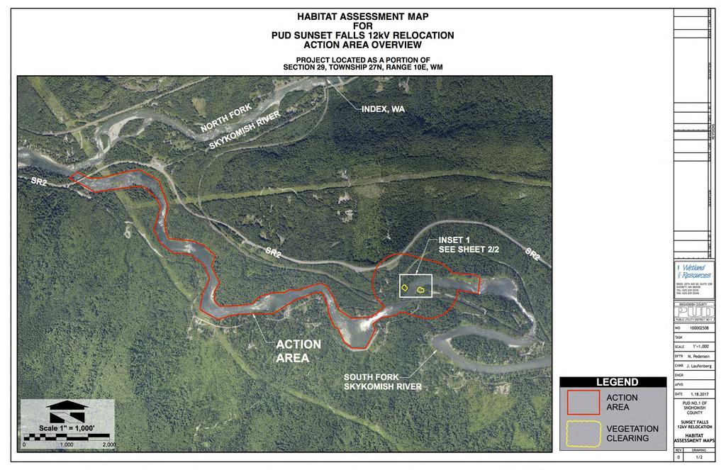
75
 DESCRIPTION HABITAT ASSESSMENT MAP FOR PUD SUNSET FALLS 12kV RELOCATION INSET 1 DESCRIPTION ENGR OHWM")
76 APVD CHKR ENGR VICINITY MAP SR2 217 TH P PROJECT LOCATED AS A PORTION OF SECTION 29, TOWNSHIP 27N, RANGE 10E, WM L SE INSET INSET 1 SKYKOM ISH R. MT. IN DE XR IVE RR D CHKR 21 APVD 7T No REVISIONS H DATE PL BY SE FEMA FLOODPLAIN (FLOODWAY FRINGE) DESCRIPTION HABITAT ASSESSMENT MAP FOR PUD SUNSET FALLS 12kV RELOCATION INSET 1 DESCRIPTION ENGR OHWM S. FORK SKYKOMISH R. 1 2 WIRE NEW 12kV DISTRIBUTION LINE 3 CLEAR EXISTING NATIVE VEGETATION FOR WIRE CORRIDOR (3,169 SF) 2 DATE CLEAR EXISTING NATIVE VEGETATION FOR WIRE CORRIDOR (4,128 SF) No 3,169 SF CLEARING AREA FOR NEW DISTRIBUTION LINE ~4,128 SF CLEARING AREA FOR NEW DISTRIBUTION LINE 1 BY WORK AREA NOTES TH AVE SE, SUITE 106 EVERETT, WA TEL: FAX: SNOHOMISH COUNTY 3 PUBLIC UTILITY DISTRICT NO 1 HA MAP LEGEND 60 SCALE SHEET 2/2WO LEGEND NEW 12kV DISTRIBUTION LINE SOUTH FORK SKYKOMISH RIVER Scale 1" = 60' FEMA FLOODPLAIN EX AD D O IN R. T R M IVE R FEMA FLOODPLAIN (FLOODWAY FRINGE) VEGETATION CLEARING TASK SCALE 1"=60' DFTR N. Pedersen CHKR J. Laufenberg ENGR APVD SKYKOMISH RIVER OHWM NEW 12kV DIST. POLE OHWM S. FORK SKYKOMISH R. DATE PUD NO.1 OF SNOHOMISH COUNTY SUNSET FALLS 12kV RELOCATION HABITAT ASSESSMENT MAPS HA MAP LEGEND 60 SCALE SHEET 1/2 REV DRAWING 0 2/2
MUCKLESHOOT INDIAN TRIBE Fisheries Division nd Avenue SE Auburn, Washington
 MUCKLESHOOT INDIAN TRIBE Fisheries Division 39015-172 nd Avenue SE Auburn, Washington 98092-9763 Phone: (253) 939-3311 Fax: (253) 931-0752 Scott Sissons Pierce County Planning and Land Services 2401 South
Funding Guidelines State Fiscal Year 2016
 State Fiscal Year 2016 Water Quality Financial Assistance Centennial Clean Water Program Clean Water Act Section 319 Program Stormwater Financial Assistance Program Washington State Water Pollution Control
Appendix I: ESA Section 7 Letters of Concurrence
 Appendix I: ESA Section 7 Letters of Concurrence I1: NMFS/USFWS Letter of Concurrence dated June 25, 2008 I2: USFWS Letter of Concurrence dated May 18, 2010 I3: NMFS Letter of Concurrence dated March 28,
Endangered Species Act: Federal Nexus and Consultations on Floodplain Mapping. Skagit River flood1995, Allen Kam, NOAA
 Endangered Species Act: Federal Nexus and Consultations on Floodplain Mapping Skagit River flood1995, Allen Kam, NOAA Presentation Overview Endangered Species Act; Purpose and Requirements for Consultation
SHORELINE INVENTORY AND RESTORATION PLANNING
 CHAPTER 3 SHORELINE INVENTORY AND RESTORATION PLANNING A. PURPOSE OF THE SHORELINE INVENTORY AND CHARACTERIZATION A first step in the comprehensive Master Program update process is development of a shoreline
The Science Behind Forest Riparian Protection in the Pacific Northwest States By George Ice, Summer 2004
 The Science Behind Forest Riparian Protection in the Pacific Northwest States By George Ice, Summer 2004 Riparian buffers, streamside management zones, and similar measures are essential parts of forest
PRE-PROPOSAL FORM Lewis River Aquatic Fund 2011
 PRE-PROPOSAL FORM Lewis River Aquatic Fund 2011 Form Intent: To provide a venue for an applicant to clearly indicate the technical basis and support for proposed project. Specifically the project s consistency
BMP 5.4.2: Protect /Conserve/Enhance Riparian Areas
 BMP 5.4.2: Protect /Conserve/Enhance Riparian Areas The Executive Council of the Chesapeake Bay Program defines a Riparian Forest Buffer as "an area of trees, usually accompanied by shrubs and other vegetation,
Appendix E : Guidelines for Riparian Buffer Areas
 Appendix E : Guidelines for Riparian Buffer Areas This document should be read in conjunction with the CRCA Planning Policy. 1.0 PURPOSE The purpose of this document is to summarize the recommendations
Warren Wagon Road Improvement Project McCall Ranger District, Payette National Forest Project Description
 Warren Wagon Road Improvement Project McCall Ranger District, Payette National Forest Project Description Introduction The analysis of the Warren Wagon Road Improvement Project is tiered to the 2003 Environmental
3.14 EAST STRAIT INDEPENDENT DRAINAGES RECOMMENDATIONS
 Chapter 3.14 East Strait Independent Drainages Page 3.14-1 3.14 EAST STRAIT INDEPENDENT DRAINAGES RECOMMENDATIONS Section 3.4 contains recommendations for instream flows and Section 3.3 contains other
ELK RAPIDS TOWNSHIP WATER QUALITY ACTION PLAN
 ELK RAPIDS TOWNSHIP WATER QUALITY ACTION PLAN Elk-River-Chain-of-Lakes Gaps Analysis Project The Watershed Center Grand Traverse Bay Tip of the Mitt Watershed Council Michigan Department of Natural Resources
Western Strait Drainages. Watershed Summaries DRAINAGES EST WRIA 19 EST
 Page 31 WESTERN STRAIT DRAINAGES EST WRIA 19 WEST EST Snow, Bullman, Jansen & Olsen Creeks Sekiu River Hoko & Little Hoko Rivers Clallam River & Estuary Pysht River & Estuary Green Creek Jim & Joe Creeks
TIERING DOCUMENTATION FORM FOR PRE-COMMERCIAL THIN AND RELEASE/FUELS HAZARD REDUCTION ON THE KLAMATH NATIONAL FOREST
 TIERING DOCUMENTATION FORM FOR PRE-COMMERCIAL THIN AND RELEASE/FUELS HAZARD REDUCTION ON THE KLAMATH NATIONAL FOREST Ranger District: Salmon Ranger District Date Prepared: 7/11/2011 Project Name: Knownothing
Chehalis Basin Strategy Programmatic SEPA Draft EIS
 Chehalis Basin Strategy Programmatic SEPA Draft EIS History of Flooding I-5 closed in 1990, 1996, 2007, 2009 Five largest flood events occurred since 1986 2 History of Habitat Degradation Harvest has been
Meacham Creek Restoration Project
 Meacham Creek Restoration Project Meacham Creek Restoration Project Umatilla National Forest Walla Walla Ranger District Michael Rassbach, District Ranger Public Scoping Document Proposal Summary The Walla
Environmental Assessment Form Part 1 Resource Identification Enclosure C Description of Aquatic Habitat
 Environmental Assessment Form Part 1 Resource Identification Enclosure C Description of Aquatic Habitat 8. Provide a written narrative, identified and labeled as Enclosure C Description of Aquatic Habitat,
Logo Department Name Agency Organization Organization Address Information Petersburg Ranger District P.O. Box 1328 Agriculture
 Logo Department Name Agency Organization Organization Address Information United States Forest Tongass National Forest Petersburg Ranger District Department of Service Alaska Region P.O. Box 1328 Agriculture
S.R. 4007, Section 14B PADEP Environmental Assessment Form. Enclosure C Description of Aquatic Habitat
 S.R. 4007, Section 14B PADEP Environmental Assessment Form Description of Aquatic Habitat Cresheim Creek is the only water resource that exists within the project area. No jurisdictional wetlands were
TORCH LAKE TOWNSHIP WATER QUALITY ACTION PLAN
 TORCH LAKE TOWNSHIP WATER QUALITY ACTION PLAN Elk-River-Chain-of-Lakes Gaps Analysis Project The Watershed Center Grand Traverse Bay Tip of the Mitt Watershed Council Michigan Department of Natural Resources
Projects must fall under one of the nine categories listed in Table 1.
 UNITED STATES DEPARTMENT OF COMMERCE National Oceanic and Atmospheric Administration NATIONAL MARINE FISHERIES SERVICE West Coast Region Snake Basin Office 800 Park Boulevard, Plaza IV, Suite 220 Boise,
Agency Organization Organization Address Information. Name United States Department of Agriculture
 Logo Department Name United States Department of Agriculture Agency Organization Organization Address Information Forest Service Pacific Northwest Region 1220 SW Third Avenue (97204) P.O. Box 3623 Portland,
Public Notice: Application for Permit
 US Army Corps Of Engineers Walla Walla District 201 North Third Avenue Walla Walla, WA 99362-1876 Public Notice: Application for Permit APPLICATION NO.: NWW-2012-127-I02 WATERWAY: Big Wood River APPLICANT:
Case Studies III: Skokomish River Ecosystem Restoration Washington State
 University of Massachusetts - Amherst ScholarWorks@UMass Amherst International Conference on Engineering and Ecohydrology for Fish Passage International Conference on Engineering and Ecohydrology for Fish
3. Identification of problem or opportunity to be addressed
 1. Project Title Clearwater Creek Instream Habitat Restoration 2. Project Manager Adam Haspiel Mt. St. Helens National Volcanic Monument 42218 NE Yale Bridge Road Amboy, WA 98604 360-449-7833 360-449-7801
Chapter 10 Natural Environment
 Chapter 10 Natural Environment Existing Conditions The Natural Environment Element addresses the protection, conservation, preservation, and restoration of the natural resources the Bayview Ridge Subarea,
APPENDIX B EFFECTS TO PHYSICAL AND BIOLOGICAL ENVIRONMENT
 APPENDIX B EFFECTS TO PHYSICAL AND BIOLOGICAL ENVIRONMENT Botany No known proposed, endangered, threatened, and sensitive vascular plant, bryophyte, lichen and fungi (PETS) species are present within the
SKAGIT COUNTY PLANNING AND DEVELOPMENT SERVICES FINDINGS OF FACT. APPLICATION NUMBER: Shoreline Substantial Development Application PL
 SKAGIT COUNTY PLANNING AND DEVELOPMENT SERVICES FINDINGS OF FACT HEARING AUTHORITY: Skagit County Hearing Examiner HEARING DATE: April 24, 2013 APPLICATION NUMBER: Shoreline Substantial Development Application
DECISION MEMO. West Fork Blacktail Deer Creek Hardened Crossing
 Page 1 of 6 Background DECISION MEMO USDA Forest Service Madison Ranger District Madison County T12S, R4W, Section 30 The project is in the Gravelly Landscape, Snowcrest Recommended Wilderness Management
Request for Proposal Scope Development Guide. Asotin County Geomorphic Assessment. and. Conceptual Restoration Plan
 Request for Proposal Scope Development Guide Asotin County Geomorphic Assessment and Conceptual Restoration Plan Asotin County Conservation District December 3, 2015 1 1.0 INTRODUCTION The Asotin County
Chapter FISH AND WILDLIFE HABITAT CONSERVATION AREAS
 Chapter 18.24 FISH AND WILDLIFE HABITAT CONSERVATION AREAS Sections: 18.24.010 Designation of fish and wildlife habitat conservation areas. 18.24.020 Report Additional requirements for habitat conservation
Clallam County Shoreline Master Program Update
 Clallam County Shoreline Master Program Update Board of Commissioners Work Session November 13, 2017 Topics Buffers Channel Migrations Zones (CMZs) Mitigation and No Net Loss Importance of Buffers Provide
Recommendations on Making Small Shoreline Buffers Work with Buffer Science
 Recommendations on Making Small Shoreline Buffers Work with Buffer Science Note: this document will be updated with additional science citations in the future, please check our website for the current
MILTON TOWNSHIP WATER QUALITY ACTION PLAN
 MILTON TOWNSHIP WATER QUALITY ACTION PLAN Elk-River-Chain-of-Lakes Gaps Analysis Project The Watershed Center Grand Traverse Bay Tip of the Mitt Watershed Council Michigan Department of Natural Resources
VEGETATIVE, WATER, FISH AND WILDLIFE RESOURCES POLICIES
 VEGETATIVE, WATER, FISH AND WILDLIFE RESOURCES POLICIES The County will: GOALS AND OBJECTIVES 1.1 Conserve, Enhance, Protect, Maintain and Manage Vegetative, Water, Fish and Wildlife Resources Promote
CLEARWATER TOWNSHIP WATER QUALITY ACTION PLAN
 CLEARWATER TOWNSHIP WATER QUALITY ACTION PLAN Elk-River-Chain-of-Lakes Gaps Analysis Project The Watershed Center Grand Traverse Bay Michigan Department of Environmental Quality July 2011 Purpose The Grand
STATE ENVIRONMENTAL POLICY ACT MITIGATED DETERMINATION OF NONSIGNIFICANCE
 n+ Skamania County Community Development Department Building/Fire Marshal Environmental Health Planning Skamania County Courthouse Annex Post Office Box 1009 Stevenson, Washington 98648 Phone: 509-427-3900
Central Strait Drainages DRAINAGES AST WRIA 19 AST
 Page 41 CENTRAL STRAIT DRAINAGES AST WRIA 19 EAST AST Deep Creek East Twin River E. Fork East Twin & Sadie Creek West Twin River Lake Crescent / Lyre River System Murdock Creek Field, Whiskey & Colville
Public Notice: Application for Permit
 U.S. ARMY CORPS Of Engineers Walla Walla District 201 North Third Avenue Walla Walla, WA 99362-1876 Public Notice: Application for Permit APPLICATION NO.: NWW-2014-00446 WATERWAY: Snake River APPLICANT:
DECISION MEMO. Crow Creek Hardened Crossing
 Page 1 of 5 DECISION MEMO USDA Forest Service Madison Ranger District Madison County T12S, R4W in Section 35 Background A perennial cattle crossing on Crow Creek in in the Gravelly Landscape in the Centennial
Department of the Army Permit Application
 Department of the Army Permit Application DA File Number U.S. Army Corps of Engineers Honolulu District Date Received by CEPOH-RO Send Completed Application to: Honolulu District, U.S. Army Corps of Engineers
POLICY FOR NATURAL RESOURCE MANAGEMENT AREAS
 POLICY FOR NATURAL RESOURCE MANAGEMENT AREAS I. POLICY STATEMENT Auburn University's (the University's) "Policy for Natural Resource Management Areas" implements the Campus Master Plan Land Use Element
SKOKOMISH RIVER BASIN MASON COUNTY, WASHINGTON ECOSYSTEM RESTORATION
 SKOKOMISH RIVER BASIN MASON COUNTY, WASHINGTON ECOSYSTEM RESTORATION APPENDIX G ECONOMICS Integrated Feasibility Report and Environmental Impact Statement This page was intentionally left blank to facilitate
CHAPTER 7. San Dieguito River Flooding Adaptation
 CHAPTER 7 San Dieguito River Flooding Adaptation This chapter includes a range of adaptation measures to address vulnerabilities from flooding along the San Dieguito River, including the river valley,
Public Notice: Application for Permit
 US Army Corps Of Engineers 201 North Third Avenue Walla Walla, WA 99362-1876 Public Notice: Application for Permit APPLICATION NO.: WATERWAY: Big Wood River APPLICANT: James E. Daverman, Dwayne Clark,
DRAFT FINDING OF NO SIGNIFICANT IMPACT. for. Tioga Sports Park
 DRAFT FINDING OF NO SIGNIFICANT IMPACT for Tioga Sports Park The U.S. Fish and Wildlife Service (USFWS) prepared an Environmental Assessment (EA) to analyze the potential effects of the proposal by the
Exhibit B Shoreline Checklist & Statement of Exemption Form for Ensuring Consistency with SMP Policies and Regulations and No Net Loss Policy
 CLALLAM COUNTY Department of Community Development 223 East 4th Street, Suite 5 Port Angeles Washington 98362 360-417-2420 Exhibit B Shoreline Checklist & Statement of Exemption Form for Ensuring Consistency
Public Notice. Public Notice No. Date: April 8, 2016 CENAP-PL-E Comment Period Closes: May 9, 2016
 Public Notice Public Notice No. Date: April 8, 2016 CENAP-PL-E-16-02 Comment Period Closes: May 9, 2016 USACE Philadelphia District: http://www.nap.usace.army.mil COBBS CREEK FISH PASSAGE PROJECT SECTION
S.R. 2027, Section 02B PADEP Environmental Assessment Form. Enclosure C Description of Aquatic Habitat
 S.R. 2027, Section 02B PADEP Environmental Assessment Form Description of Aquatic Habitat Water resources that exist within the project area include Hosensack Creek and two palustrine emergent (PEM) wetlands.
Table 1. Relationship between critical areas and key functions. Shaded areas represent functions associated with each critical area. Storage.
 Flow Storage Nutrients Temperature Bacteria Contaminants Cowlitz County Voluntary Stewardship Program 4 Goals, Benchmarks, Strategies and Indicators 4.1 Approach Goals and Benchmarks Critical Areas Functions
Biological Opinion. Morse Brothers Habitat Restoration Project. Endangered Species Act - Section 7 Consultation
 Endangered Species Act - Section 7 Consultation Biological Opinion Morse Brothers Habitat Restoration Project Agency: Army Corps of Engineers, Portland District Consultation Conducted By: National Marine
3.4 AQUATIC ECOSYSTEMS AND FISH SPECIES
 3.4 AQUATIC ECOSYSTEMS AND FISH SPECIES The following section supplements the analysis found in Chapter Three, Section 3.4 - Aquatic Ecosystems and Fish Species of the Draft EIS on page 3.59, Impacts Related
VILLAGE OF BELLAIRE WATER QUALITY ACTION PLAN
 VILLAGE OF BELLAIRE WATER QUALITY ACTION PLAN Elk-River-Chain-of-Lakes Gaps Analysis Project The Watershed Center Grand Traverse Bay Tip of the Mitt Watershed Council Michigan Department of Natural Resources
CHAPTER 7. San Dieguito River Flooding Adaptation
 CHAPTER 7 San Dieguito River Flooding Adaptation This chapter includes a range of adaptation measures to address vulnerabilities from flooding along the San Dieguito River, including the river valley,
BANKS TOWNSHIP WATER QUALITY ACTION PLAN
 BANKS TOWNSHIP WATER QUALITY ACTION PLAN Elk-River-Chain-of-Lakes Gaps Analysis Project The Watershed Center Grand Traverse Bay Tip of the Mitt Watershed Council Michigan Department of Natural Resources
18 Little White Salmon Subbasin
 18 Little White Salmon Subbasin Figure 18-1. Location of the Little White Salmon River Subbasin within the Lower Columbia River Basin. 18.1 Basin Overview The Little White Salmon Subbasin encompasses approximately
5.4 Alternative 2: Structural Flood Protection Without Flood Retention Facility
 5.4 Alternative 2: Structural Flood Protection Without Flood Retention Facility Structural Flood Protection Without Flood Retention Facility (Alternative 2) would reduce flood damage during a major flood
5. Other Environmental Consequences
 5. Other Environmental Consequences 5.1 Unavoidable Adverse Impacts Impacts to the following environmental resources were evaluated for Alternative D, the preferred alternative, to determine if they would
Juncrock Timber Sale Draft Environmental Impact Statement. Appendix G Soils
 Juncrock Timber Sale Draft Environmental Impact Statement Appendix G Soils Soil Condition Monitoring on the Barlow Ranger District of the Mt. Hood National Forest 1999 The Barlow Ranger District conducts
Attachment D CITY OF SNOHOMISH SHORELINE MASTER PROGRAM. Shoreline Inventory and Characterization
 Attachment D CITY OF SNOHOMISH SHORELINE MASTER PROGRAM Shoreline Inventory and Characterization Prepared for June 2010, updated May 2017 Shoreline Master Program Shoreline Inventory and Characterization
3 Baseline and Existing Conditions
 1 2 3 4 5 6 7 8 9 10 11 12 13 14 3 Baseline and Existing Conditions The effective date of the VSP legislation is July 22, 2011. This is also the date chosen by the legislature as the applicable baseline
Model Riparian Buffer Ordinance.
 Model Riparian Buffer Ordinance. This is a sample riparian buffer ordinance written as an amendment to an existing zoning ordinance. This ordinance complies with the state minimum standards for river corridor
RIPARIAN AREAS REGULATION
 Definitions and interpretation RIPARIAN AREAS REGULATION 1 (1) In this regulation: Act means the Fish Protection Act; active floodplain means an area of land that supports floodplain plant species and
5.2 BIOLOGICAL RESOURCES AND WETLANDS
 5.2 BIOLOGICAL RESOURCES AND WETLANDS 5.2.1 INTRODUCTION This section discusses potential adverse effects to vegetation communities and special status species. Effects would be considered adverse if the
404(b)(1) EVALUATION
(1) EVALUATION") 404(b)(1) EVALUATION SECTION 404(b)(1) EVALUATION DETAILED PROJECT REPORT AND ENVIRONMENTAL ASSESSMENT POMEROY SECTION 14 EMERGENCY STREAMBANK PROTECTION PROJECT POMEROY, OH I. INTRODUCTION As required
404(b)(1) EVALUATION SECTION 404(b)(1) EVALUATION DETAILED PROJECT REPORT AND ENVIRONMENTAL ASSESSMENT POMEROY SECTION 14 EMERGENCY STREAMBANK PROTECTION PROJECT POMEROY, OH I. INTRODUCTION As required
Will County Site Development Permit Submittal Checklist TAB 1 PROJECT OVERVIEW
 Applicant: Reviewer: Permit No.: The following tables contain a checklist of the requirements before a review for a Site Development Permit submittal will be accepted. Not all requirements pertain to every
DECISION MEMO Robinhood Creek Helicopter Log Deck June, 2008
 DECISION MEMO Robinhood Creek Helicopter Log Deck June, 2008 USDA Forest Service, Mt. Hood National Forest Hood River Ranger District Hood River County, Oregon Flooding in the fall of 2006 caused significant
APPENDIX E SECTION 404 (B) (1) EVALUATION OF DREDGE AND FILL MATERIAL
 (1) EVALUATION OF DREDGE AND FILL MATERIAL") APPENDIX E SECTION 404 (B) (1) EVALUATION OF DREDGE AND FILL MATERIAL SECTION 404 (B) (1) EVALUATION FOR AUGUSTA ROCKY CREEK SECTION 205 FEASIBILITY STUDY, RICHMOND COUNTY, GEORGIA FEBRUARY 2016 TABLE
APPENDIX E SECTION 404 (B) (1) EVALUATION OF DREDGE AND FILL MATERIAL SECTION 404 (B) (1) EVALUATION FOR AUGUSTA ROCKY CREEK SECTION 205 FEASIBILITY STUDY, RICHMOND COUNTY, GEORGIA FEBRUARY 2016 TABLE
GRAYS HARBOR ESTUARY MANAGEMENT UNIT GRAYS HARBOR ESTUARY
 GRAYS HARBOR ESTUARY MANAGEMENT UNIT GRAYS HARBOR ESTUARY Description: The Grays Harbor Estuary is a bar-built estuary that was formed by the combined processes of sedimentation and erosion caused by both
Stormwater Erosion Control & Post-Construction Plans (Stormwater Quality Plans)
") Stormwater Erosion Control & Post-Construction Plans (Stormwater Quality Plans) Allen County Stormwater Plan Submittal Checklist The following items must be provided when applying for an Allen County Stormwater
Stormwater Erosion Control & Post-Construction Plans (Stormwater Quality Plans) Allen County Stormwater Plan Submittal Checklist The following items must be provided when applying for an Allen County Stormwater
8. A. AQUATIC HABITATS
 ENCLOSURE C S.R. 1006 SECTION 80S DELAWARE CANAL BRIDGE REHABILITATION PROJECT, TINICUM TOWNSHIP, BUCKS COUNTY, PENNSYLVANIA DESCRIPTION OF AQUATIC HABITAT 8. A. AQUATIC HABITATS (1) Food Chain Production-
Inventory of Management Programs
 Appendix C Salmon Recovery Plan Inventory of s Table 1 Inventory of management programs, sponsors or agencies, area affected by the programs, goal of the programs, and a determination whether the program
SR 202 Stream and Wetland Mitigation:
 SR 202 Stream and Wetland Mitigation: by Jon Gage, RLA, David Evans and Associates, Inc. Introduction WETLAND mitigation for the State Route 202 highway widening project by the Washington State Department
STATE ENVIRONMENTAL POLICY ACT MITIGATED DETERMINATION OF NONSIGNIFICANCE
 n+ Skamania County Community Development Department Building/Fire Marshal Environmental Health Planning Skamania County Courthouse Annex Post Office Box 1009 Stevenson, Washington 98648 Phone: 509-427-3900
Environmental Check List Georgia Environmental Policy Act
 Environmental Check List Georgia Environmental Policy Act Project No. : Project Name: GEORGIA IS AREA AFFECTED? IF AFFECTED, HOW SEVERELY? AREA/CATEGORY NO YES UNKNOWN MINOR MEDIAN MAJOR UNKNOWN 1. Wetlands
Assessing Habitat in Watersheds. Sabrina Drill UC Cooperative Extension Los Angeles and Ventura
 Assessing Habitat in Watersheds Sabrina Drill UC Cooperative Extension Los Angeles and Ventura sldrill@ucdavis.edu 323-260 260-3404 What is Habitat? The environment in which a plant and animal lives, and
Ongoing and Completed Studies
 Attachment 2 Ongoing and Completed Studies 2014 Monitoring and Analysis Plan November 2013 Attachment 2 Ongoing and Completed Studies 1 Introduction In 2013, the small interdisciplinary study groups for
DECISION MEMO FOR CATEGORICAL EXCLUSION HOLY JIM CREEK CROSSING REPLACEMENT
 DECISION MEMO FOR CATEGORICAL EXCLUSION HOLY JIM CREEK CROSSING REPLACEMENT U.S.D.A. Forest Service Cleveland National Forest Trabuco Ranger District Orange County, California Background The current configuration
ENVIRONMENTAL RESOURCE PERMIT APPLICATION
 ENVIRONMENTAL RESOURCE PERMIT APPLICATION SOUTHWEST FLORIDA WATER MANAGEMENT DISTRICT 2379 BROAD STREET, BROOKSVILLE, FL 34604-6899 (352) 796-7211 OR FLORIDA WATS 1 (800) 423-1476 SECTION E INFORMATION
16.1 Significant and Unavoidable Impacts
 Chapter 16 NEPA requires an EIS and CEQA requires an EIR to evaluate a number of other types of environmental impacts in addition to those already addressed in the resource chapters. The analysis required
CITY OF NEW WESTMINSTER. Bylaw No. 7033, 2005 RIPARIAN AREAS PROTECTION BYLAW
 CITY OF NEW WESTMINSTER Bylaw No. 7033, 2005 RIPARIAN AREAS PROTECTION BYLAW WHEREAS the City may preserve, protect, restore and enhance the natural environment near streams that support fish habitat from
Scientific Literature Review of Forest Management Effects on Riparian Functions for Anadromous Salmonids
 Scientific Literature Review of Forest Management Effects on Riparian Functions for Anadromous Salmonids Presentation to: The California State Board of Forestry and Fire Protection Prepared by: Mike Liquori
Appendix 3-B: Limiting Factors Analysis
 Appendix 3-B: Limiting Factors Analysis WRIA 18 Watershed Plan Limiting Factors Analysis for WRIA 18, Recommendations Page 1 Salmon and Steelhead abitat Limiting Factors WRIA 18 Lead Agency: Washington
Appendix B Stormwater Site Plan Submittal Requirements Checklist
 Stormwater Site Plan Submittal Requirements Checklist The Submittal Requirements Checklist is intended to aid the design engineer in preparing a Stormwater Site Plan. All items included in the following
The Shiraz model A tool for incorporating anthropogenic effects and fish habitat relationships in conservation planning
 The Shiraz model A tool for incorporating anthropogenic effects and fish habitat relationships in conservation planning Mark D. Scheuerell National Marine Fisheries Service Seattle, WA Acknowledgments
APPENDIX P EL DORADO COUNTY GENERAL PLAN: APPLICABLE SECTIONS FROM CONSERVATION AND OPEN SPACE ELEMENT
 APPENDIX P EL DORADO COUNTY GENERAL PLAN: APPLICABLE SECTIONS FROM CONSERVATION AND OPEN SPACE ELEMENT SOIL CONSERVATION OBJECTIVE 7.1.2: EROSION/SEDIMENTATION Minimize soil erosion and sedimentation.
STAFF REPORT CHELAN COUNTY PUD DAROGA DOMESTIC WATER SYSTEM
 STAFF REPORT CHELAN COUNTY PUD DAROGA DOMESTIC WATER SYSTEM TO: Douglas County Hearing Examiner FROM: Douglas County Land Services Staff RE: Chelan County PUD, SCUP-12-01 DATE: July 5, 2012 I. GENERAL
CATEGORY a protection of the natural environment, its ecosystems and biodiversity.
 29. ENVIRONMENTAL DEVELOPMENT PERMIT AREA CATEGORY a protection of the natural environment, its ecosystems and biodiversity. The requirement to obtain an environmental development permit is cited in Section
Hood River Watershed Group to sustain and improve the Hood River watershed through education, cooperation, and stewardship
 You are living in a watershed A watershed is the land area that drains to a particular lake, stream, or river. The Hood River watershed covers 339 square miles between Mt. Hood and the Columbia River.
Public Notice of Application for Permit
 US Army Corps of Engineers Alaska District Juneau Field Office Regulatory Division (1145) CEPOA-RD 8800 Glacier Highway, Suite 106 Juneau, Alaska 99801-8079 Public Notice of Application for Permit PUBLIC
Moonlight Aquatic Organism Passage Project
 Notice of Proposed Action Moonlight Aquatic Organism Passage Project Mt. Hough Ranger District Plumas National Forest Plumas County, California Figure 1. Hungry 1 aquatic organism passage outlet showing
PROJECT SCREENING MATRIX: A User s Guide
 Version 2.0 Page 1 of 7 November 9, 2010 PROJECT SCREENING MATRIX: A User s Guide BACKGROUND The Project Screening Matrix (Screening Matrix) is one of several tools that comprise the River Restoration
CATEGORICAL EXCLUSION REVIEW - NEPA COMPLIANCE RECORD
 U.S. DEPARTMENT OF THE INTERIOR BUREAU OF LAND MANAGEMENT SALEM DISTRICT OFFICE Marys Peak Resource Area Lincoln County, Oregon CATEGORICAL EXCLUSION REVIEW - NEPA COMPLIANCE RECORD Project: Miami Corporation
~ate: d~o/~o/h. h ~~~ Date:,;z//o/a?0/6. Managing Water in the West. Upper Sacramento River Anadromous Fish Habitat Restoration Project
 M Managing Water in the West Finding of No Significant Impact Upper Sacramento River Anadromous Fish Habitat Restoration Project Recommended by: ~~ Ben Nelson Natural Resources Specialist Bay-Delta Office
Project sponsors provided a brief presentation on their project(s), followed by comments from the Committee.
, followed by comments from the Committee.") WRIA 14 Salmon Habitat Recovery Committee Meeting April 17, 2014 Summary notes Project sponsors provided a brief presentation on their project(s), followed by comments from the Committee. Allyn Shoreline
WRIA 14 Salmon Habitat Recovery Committee Meeting April 17, 2014 Summary notes Project sponsors provided a brief presentation on their project(s), followed by comments from the Committee. Allyn Shoreline
STREAM INVENTORY REPORT PUDDING CREEK
 STREAM INVENTORY REPORT PUDDING CREEK WATERSHED OVERVIEW Pudding Creek is a tributary to the Pacific Ocean (Figure 1). Elevations range from sea level at the mouth of the creek to 1,600 feet in the headwater
Decision Notice/Finding of No Significant Impact 1
 DECISION NOTICE FINDING OF NO SIGNIFICANT IMPACT BULL RUN CULVERT REPLACEMENTS U.S. FOREST SERVICE WHITMAN RANGER DISTRICT, WALLOWA-WHITMAN NATIONAL FOREST GRANT COUNTY, OREGON TOWNSHIP 9 SOUTH, RANGE
Grading & Excavation Information Application & Checklist
 Grading & Excavation Information Application & Checklist Yakima County Public Services ~ Building & Fire Safety Division 128 North 2 nd Street, Yakima, WA 98901 ~ Office (509) 574-2300 Building & Fire
Steward and Associates 120 Avenue A, Suite D Snohomish, Washington Tel (360) / Fax (360)
 / Fax (360)") 1 INTRODUCTION This document provides an analysis of the Draft Washington State Forest Practices Habitat Conservation Plan (FPHCP) (Washington State Department of Natural Resources [WDNR] 2004) with the
1 INTRODUCTION This document provides an analysis of the Draft Washington State Forest Practices Habitat Conservation Plan (FPHCP) (Washington State Department of Natural Resources [WDNR] 2004) with the
THURSTON COUNTY SHORELINE MASTER PROGRAM UPDATE DRAFT SHORELINE ENVIRONMENT DESIGNATIONS
 THURSTON COUNTY SHORELINE MASTER PROGRAM UPDATE DRAFT SHORELINE ENVIRONMENT DESIGNATIONS PREPARED BY THURSTON COUNTY PLANNING DEPARTMENT BUILDING # 1, 2ND FLOOR 2000 LAKERIDGE DRIVE SW OLYMPIA, WA 98502-6045