Annual Report 2012 Hydrogeological Assessment McDonald s Corners Waste Disposal Site. Township of Lanark Highlands
|
|
|
- Michael Sims
- 6 years ago
- Views:
Transcription

1 Annual Report 2012 Hydrogeological Assessment McDonald s Corners Waste Disposal Site Township of Lanark Highlands Prepared for: Township of Lanark Highlands Box 340, 75 George Street Lanark, ON K0G 1K0 Prepared by: Stantec Consulting Ltd Lancaster Rd., Suite 200 Ottawa, ON K1B 1A7 March 27, 2013 Project No.:
2 ANNUAL REPORT 2012 HYDROGEOLOGICAL ASSESSMENT MCDONALD S CORNERS WASTE DISPOSAL SITE TABLE OF CONTENTS 1 INTRODUCTION General Site Description Geology Hydrogeology Regulatory Framework Background Ministry of the Environment Correspondence SCOPE OF WORK METHODOLOGY Sampling Quality Assurance and Quality Control Groundwater and Surface Water Quality Data RESULTS Groundwater Surface Water Quality Assurance/Quality Control Results INTERPRETATION Groundwater Impact and Plume Delineation Surface Water Impact CONCLUSIONS RECOMMENDATIONS CLOSURE Project No.: i
3 ANNUAL REPORT 2012 HYDROGEOLOGICAL ASSESSMENT MCDONALD S CORNERS WASTE DISPOSAL SITE LIST OF TABLES Table 4.1: Summary of Overburden Groundwater Elevations May 16 and October 23, Table 4.2: Summary of Bedrock Groundwater May 16 and October 23, Table 4.3: Summary of Groundwater Compliant Station Parameters Table 4.4: Summary of RUC Exceedances Table 4.5: Summary of Median Background Exceedances Table 4.6: Computed Background Values for Surface Water Stations Table 4.7: Summary of PWQO Exceedances LIST OF FIGURES Figure 1: Chloride Concentration Over Time (Overburden Aquifer)... Appendix B Figure 2: Sodium Concentration Over Time (Overburden Aquifer)... Appendix B Figure 3: Boron Concentration Over Time (Overburden Aquifer)... Appendix B Figure 4: Barium Concentration Over Time (Overburden Aquifer)... Appendix B Figure 5: TDS Concentration Over Time (Overburden Aquifer)... Appendix B Figure 6: Chloride Concentration Over Time (Bedrock Aquifer)... Appendix B Figure 7: Sodium Concentration Over Time (Bedrock Aquifer)... Appendix B Figure 8: Boron Concentration Over Time (Bedrock Aquifer)... Appendix B Figure 9: Barium Concentration Over Time (Bedrock Aquifer)... Appendix B Figure 10: TDS Concentration Over Time (Bedrock Aquifer)... Appendix B Figure 11: Chloride Concentration Over Time (Surface Water)... Appendix B Figure 12: Boron Concentration Over Time (Surface Water)... Appendix B Figure 13: Alkalinity Concentration Over Time (Surface Water)... Appendix B LIST OF DRAWINGS Drawing 1: Key Plan... Appendix A Drawing 2: Site Plan... Appendix A Drawing 3: Potentiometric Elevations, Overburden Aquifer-May... Appendix A Drawing 4: Potentiometric Elevations, Overburden Aquifer-October... Appendix A Drawing 5: Oxidation-Reduction Contour Map... Appendix A Project No.: ii
4 ANNUAL REPORT 2012 HYDROGEOLOGICAL ASSESSMENT MCDONALD S CORNERS WASTE DISPOSAL SITE LIST OF APPENDICES APPENDIX A APPENDIX B APPENDIX C APPENDIX D APPENDIX E APPENDIX F APPENDIX G APPENDIX H APPENDIX I APPENDIX J Drawings Figures Summary Analytical Tables and Laboratory Certificates of Analysis Borehole and Monitoring Well Instrumentation Logs (on CD) Provisional Certificate of Approval No Selected Correspondence between the Ministry of the Environment, Totten Sims Hubicki Associates and the Township of Lanark Highlands (on CD) 2012 Surface Water and Monitoring Well Photo Log Contingency Plan and Trigger Mechanism Historical Water Level Data (on CD) Certificate of Approval Compliance Project No.: iii
5 ANNUAL REPORT 2012 HYDROGEOLOGICAL ASSESSMENT MCDONALD S CORNERS WASTE DISPOSAL SITE 1 INTRODUCTION 1.1 General Stantec Consulting Limited (Stantec) was retained by the Township of Lanark Highlands to complete a hydrogeological assessment of the McDonald s Corners Waste Disposal Site (McDonald s Corners or site) for the 2012 operational year. The site is located in the Township of Lanark Highlands and currently operates as an active landfill under the Ontario Ministry of the Environment (MOE) Provisional Certificate of Approval (C of A) No. A451403, issued on May 25, 2000 (Appendix E) amended in October 2000 and September The purpose of the hydrogeological assessment was to determine the impacts which may be occurring within the local groundwater and surface water environments as a result of past and current waste disposal site operations. The assessment was completed for the Township of Lanark Highlands to ensure compliance with the aforementioned C of A. 1.2 Site Description The site is located on Lot 8, Concession 9 within the municipal limits of the former Township of Lavant, Dalhousie, and North Sherbrooke, in the County of Lanark. The site consists of an approved landfilling area of 2.8 hectares, within a total area of 40 hectares. The site is bounded by County Road 12 to the north, undeveloped land to the west, south and east. The site is accessible via County Road 12. A key plan and site plan are provided in Drawings 1 and 2, Appendix A. An aerial photograph of the Site is presented in Photograph 1. The UTM coordinates of the Site were obtained using the software tool Google EarthPro as the handheld GPS unit was not functioning properly during the fall site visit. The UTM coordinates are 18T metres (m) East and m North (North American Datum 1983). Project No.:

6 ANNUAL REPORT 2012 HYDROGEOLOGICAL ASSESSMENT MCDONALD S CORNERS WASTE DISPOSAL SITE Photograph 1: Aerial Photograph of McDonalds Corners waste disposal site (Google Earth Image) Geology Physiographic regions in the vicinity of the McDonald s Corners Landfill site are comprised of shallow till and rock ridges. Overburden within the immediate area of the site is comprised of clayey silt, silty clay, sand and gravel, increasing in thickness from 0 m around bedrock outcroppings to approximately 1 to 2 m in lower lying areas. Historical test pits and boreholes have indicated overburden thicknesses of up to 12 m in some locations, primarily within bedrock surface depressions. Bedrock ridges have been observed trending southwest to northeast, and ground surface elevations vary from approximately 158 m above sea level (m asl) at Dalhousie Lake (north of the site) to approximately 220 m asl south of McDonald s Corners. Bedrock geology in the vicinity of the site consists of mid to late Precambrian bedrock, and has been mapped (Freeman 1979) as carbonate meta-sediments. South of the site, meta-volcanic and felsic intrusive rocks have been mapped, and the upper portions of the underlying bedrock aquifer reportedly have iron rich pyrite zones in some locations. Historic borehole log data (Appendix D) generated during well installation activities undertaken in July 2001 and October 2003 confirmed the stratigraphic model for the site, with the observed Project No.:
7 ANNUAL REPORT 2012 HYDROGEOLOGICAL ASSESSMENT MCDONALD S CORNERS WASTE DISPOSAL SITE units being comprised of overburden peat and topsoil, grey silty clay, sand and gravel units, underlain by multicolored meta-sedimentary carbonate bedrock. The bedrock topography shows two bedrock surface troughs, one to the east and one to the south, separated by a bedrock ridge located to the immediate south of the waste disposal area Hydrogeology Based on current and historical data, the anticipated direction of groundwater flow at the subject site is to the south. Historical hydraulic testing indicated that hydraulic conductivities within the bedrock aquifer were in the range of 10-5 cm/sec. Associated pore water velocities (from 2001) were estimated to be between 10 and 100 cm/year in the overburden aquifer, and 10 and 1000 cm/year in the bedrock aquifer. Historically, horizontal and vertical gradients have been observed to range from m/m to m/m and indicate a general upward flow of groundwater, within the overburden unit. 1.3 Regulatory Framework Applicable regulations and guidelines for the site are the Reasonable Use Guidelines, the Ontario Drinking Water Quality Standards (ODWQS) and the Provincial Water Quality Objectives (PWQO). The Reasonable Use Guidelines are documented in the Water Resources Act, 1994, Guideline B-7, formerly and are designed to protect the groundwater quality in consideration of current and potential land use in the area. The Reasonable Use Criteria (RUC) are site specific and calculated using the median of the historical concentrations recorded at the background stations BH-1 (bedrock) and (overburden). The ODWQS are documented in the Safe Drinking Water Act, O. Reg 169/03, amended to O. Reg.248/06. Their purpose is to provide a province-wide drinking water quality standard for the water derived from the end of distribution system. The ODWQS may be applied to a groundwater source depending on the nature of water use. The Provincial Water Quality Objectives are documented in the Water Management Policies, Guidelines, Provincial Water Quality Objectives of the Ministry of Environment and Energy, (Ontario MOEE, July 1994 and reprinted 1999). The PWQOs require a minimum acceptable level of surface water quality as a simple, surrogate measure of ecosystem health. 1.4 Background Based on a review of the annual monitoring reports prepared by others for the 1997 to 2005 operational years, and by Stantec (formerly Jacques Whitford) for the 2006 to 2010 operational years, three separate groundwater plumes have been identified: an overburden aquifer leachate plume to the east, a bedrock aquifer leachate plume to the east, and a bedrock aquifer leachate Project No.:
8 ANNUAL REPORT 2012 HYDROGEOLOGICAL ASSESSMENT MCDONALD S CORNERS WASTE DISPOSAL SITE plume to the south of the active landfill area. Previous RUC and ODWQS exceedances have been noted at proximal and distal stations within the property boundaries. Noted key landfill leachate parameters include boron, sodium, chloride, barium, and total dissolved solids for the site. Samples tested from surface water monitoring stations southwest and east of the active site have regularly exceeded the PWQO for ammonia, total phosphorus, boron, iron, and phenols during both the spring and fall monitoring events. Surface water flow at the site trends to the east and to the southwest, draining to the east and west of the landfill respectively. Historically, the site has been in compliance with its C of A. 1.5 Ministry of the Environment Correspondence Selected correspondence between the MOE, and the Township of Lanark Highlands is contained in Appendix F. As indicated, a number of issues were raised with respect to groundwater monitoring at the site by the MOE hydrogeologist. The memorandum dated February 3, 2009 included a request for additional clarification of the exact location of surface water monitoring location SW-5. The memorandum dated December 18, 2007 included requests for: additional descriptions of all surface water monitoring locations; additional information with respect to the nature and extent of the surface water features at the site and how they may be interacting with groundwater; a request to expand the listing of groundwater sampling indicator parameters; and further clarification to the contingency plan for the site including determinations on when confirmatory samples are to be collected, if required. The TSH (now AECOM) letter dated January 2, 2008 was drafted in response to the two memorandums. At the present time no further changes will be made with respect to the groundwater monitoring program at the site, as the current program has already been approved by the Director. Further clarifications with respect to the timing of confirmatory sampling, if required, were provided in the TSH (now AECOM) letter. Recording of detailed descriptions and photos of each surface water monitoring location, was undertaken as part of the 2008 to 2012 work programs and will be done for all monitoring programs from now on, as outlined in Appendix E. The 2012 surface water station photolog is found in Appendix H. In addition to the memorandum received from the MOE hydrogeologist in December of 2007, an inspection report for the site was received from the MOE Senior Environmental Officer on September 18, Issues of concern relating to the hydrogeological assessment undertaken in 2006 included questions with respect to the groundwater monitoring frequency, which is stipulated as biannually in the C of A. However, a letter received from the MOE on April 8, 2005 concurred with a reduced groundwater monitoring program proposed in the 2003 annual Project No.:
9 ANNUAL REPORT 2012 HYDROGEOLOGICAL ASSESSMENT MCDONALD S CORNERS WASTE DISPOSAL SITE monitoring report, including a reduction in the groundwater monitoring program frequency to annually. The MOE has confirmed concurrence with the present groundwater monitoring program, as indicated in the follow-up letter dated October 19, 2007 and contained in Appendix G for reference. Project No.:
10 ANNUAL REPORT 2012 HYDROGEOLOGICAL ASSESSMENT MCDONALD S CORNERS WASTE DISPOSAL SITE 2 SCOPE OF WORK The proposed scope of work for the 2012 hydrogeological assessment was summarized in the 2011 Annual Monitoring Report (including the proposed 2012 work plan) that was submitted to the Township of Lanark Highlands in February Unless otherwise indicated, the scope of work for the 2012 operational year was based on the recommendations provided in the 2011 Annual Monitoring report and included: Conducting a focused groundwater sampling program. The program consisted of fall sampling of the compliant monitoring stations (03-02S&D and 03-01S&D), proximal stations (01-07S&D, 01-06S&D, 01-03S&D, 01-04S&D), and stations 00-01, 00-02, 00-03, 01-01, 01-02, BH-1, BH-2 and BH-3 for analysis of leachate indicators boron, chloride, sodium, barium and total dissolved solids (TDS);A spring sampling of the groundwater wells to the southwest (00-02, BH-3, 01-04S&D, 03-02S&D, 01-03S&D) of the Site was conducted for the analysis of TDS; All proximal and downgradient surface water stations (SW-1 to SW-6) were sampled in the early spring and fall, when possible. The surface water samples were analysed for leachate indicators total dissolved solids (TDS), biological oxygen demand (BOD), chemical oxygen demand (COD), alkalinity, hardness, chloride, total dissolved solids (TSS), ammonia, un-ionized ammonia, total nitrates, nitrite, total phosphorus, phenols, sulphate, and metals: aluminum, boron, copper, cobalt, iron, manganese and zinc. Field measurements included conductivity, ph, temperature, dissolved oxygen and stream flow. The landfill site compliance with respect to applicable RUC guidelines, the ODWQS for groundwater, and the PWQO was evaluated; and A hydrogeological assessment report documenting the activities of the 2012 operational year (this report) was prepared. Project No.:
11 ANNUAL REPORT 2012 HYDROGEOLOGICAL ASSESSMENT MCDONALD S CORNERS WASTE DISPOSAL SITE 3 METHODOLOGY 3.1 Sampling Stantec collected surface water samples from the six surface water stations (SW-1, SW-2, SW- 3, SW-4, SW-5, and SW-6) on May 16, Surface water samples were collected from four stations (SW-1, SW-2, SW-5 and SW-6) on October 23, No samples were collected from SW-3 and SW-4 during the October sampling event, as the stations were found to be dry. Groundwater samples were collected on May 16, 2012 and October 23, The groundwater samples collected during the May 16, 2012 event from monitoring wells located to the southwest of the site,were submitted for laboratory analysis of TDS only. The groundwater samples collected during the October 23, 2012 event were submitted for laboratory analysis of TDS, chloride, barium, boron and sodium. The groundwater and surface water sampling was conducted in accordance with Stantec s Ottawa office s Quality Management System (ISO 9001:2000), registered by BSI Management Systems. The groundwater and surface water samples were sent to Paracel Laboratories Ltd. (Paracel) under chain-of-custody protocol for analysis of the following parameters: Surface water: TDS, BOD, COD, alkalinity, hardness, chloride, TSS, ammonia, un-ionized ammonia, total nitrates, nitrite, total phosphorus, phenols, sulphate, and metals: aluminum, boron, copper, cobalt, iron, manganese and zinc. Groundwater: boron, sodium, chloride, barium, and TDS. Paracel is accredited by the Standards Council of Canada according to protocols provided by the Canadian Association of Environmental Analytical Laboratories (CAEAL) and employs inhouse quality assurance and quality control programs to govern sample analysis including the analysis of method blanks, spiked blanks, and the analysis of duplicates (10%) for each sample batch. 3.2 Quality Assurance and Quality Control Data quality objectives (DQO) establish the overall quality of data that will be appropriate to meet the monitoring requirement. The overall DQO for the purpose of this report, including groundwater and surface water analytical data, was to produce data that were reproducible, representative, comparable and complete. In addition, the following DQO was established for this groundwater and surface water monitoring program: Project No.:
12 ANNUAL REPORT 2012 HYDROGEOLOGICAL ASSESSMENT MCDONALD S CORNERS WASTE DISPOSAL SITE Analytical data are to be of an acceptable quality to allow for comparison with the RUC limits, ODWQS and PWQO, where applicable. To meet the DQO for the groundwater and surface water analytical data, QA/QC procedures included both laboratory and field protocols and are discussed below Groundwater and Surface Water Quality Data Efforts were made during sampling to reduce the potential for cross contamination to obtain representative samples of groundwater and surface water. Accordingly, a new pair of disposable nitrile gloves was used to collect each groundwater and surface water sample. Groundwater samples were also collected using sampling equipment dedicated to each well. Pre-cleaned sample jars provided by the laboratory with appropriate preservatives were used in the sampling. For groundwater and surface water samples, QA/QC procedures consisted of the following: Submission of one uniquely identified blind field groundwater duplicate sample and one uniquely identified blind field surface water duplicate sample for laboratory analysis of all parameters during each sampling event; Laboratory surrogate standards and recoveries. To evaluate the sampling and analytical precision, the samples and their field duplicates were used to calculate the relative percent difference (RPD). The RPD was calculated using the following formula: C1 C2 RPD 100% ( C C2 )/ 2 1 where: C1 is the concentration in the original sample; and C2 is the concentration in the duplicate sample. If the results for one of or both the original and the duplicate were below the method detection limits, the RPD was not calculated. In this case, the analytical results were assumed to have a high degree of similarity. RPDs of 30% or less were considered acceptable for groundwater and surface water analyses (Zeiner, 1994). Therefore, for the purposes of this assessment, a screening criterion of 30% was used for the assessment of QA/QC. The results of QA/QC analyses and RPD calculations are discussed in Section 4.3. Project No.:
13 ANNUAL REPORT 2012 HYDROGEOLOGICAL ASSESSMENT MCDONALD S CORNERS WASTE DISPOSAL SITE 4 RESULTS 4.1 Groundwater Groundwater elevations of the overburden and bedrock monitoring stations, listed in Table 4.1 and Table 4.2, were recorded on May 16, 2012 and October 23, The inferred potentiometric elevations within the overburden and bedrock aquifer are contained in Drawings 3 and 4, Appendix A, respectively. As indicated, flow within the overburden and bedrock units generally trends to the south across the site. Exceptionally, the May bedrock information suggests an easterly component to the groundwater flow. Recorded horizontal gradients (Tables 2 and 3, Appendix C) were estimated to be between m/m to m/m within the overburden aquifer and between m/m to m/m within the bedrock aquifer. Vertical gradients estimated in 2012 ranged between m/m (downward) at S&D to 0.01 m/m (upward) at S&D. Results indicate a downward vertical component with the exception of areas in the vicinity of S&D and S&D. Table 4.1: Summary of Overburden Groundwater Elevations May 16 and October 23, 2012 Location Total Depth of Well (m) Top of Casing Elevation(m) May 16, 2012 Ground Water Level (m btoc) 01-03S S S October 23, S S S D S S S Notes: m btoc metres below Top Of Casing. Elevations provided by TSH (now AECOM) 01-04S, 03-01S, and 03-02S elevations are from the updated 2004 survey. Ground Water Elevation (m) Project No.:
14 ANNUAL REPORT 2012 HYDROGEOLOGICAL ASSESSMENT MCDONALD S CORNERS WASTE DISPOSAL SITE Table 4.2: Summary of Bedrock Groundwater May 16 and October 23, 2012 Location Total Depth of Well (m) Top of Casing Elevation (m) May 16, 2012 Ground Water Level (m btoc) BH Overflowing > > Overflowing > D D D October 23, 2012 BH BH BH > D D D D D Notes: m btoc metres below Top Of Casing. NM Station not monitored in 2009 due to unsafe conditions Elevations provided by TSH (now AECOM) D, 03-01D, and 03-02D elevations are from the updated 2004 survey. Groundwater analytical results are presented in Tables 4 to 8 in Appendix C. Ground Water Elevation (m) A total of eight groundwater samples plus one field duplicate were submitted for laboratory analysis of TDS during the May 16, 2012 sampling event. Twenty groundwater samples were submitted for laboratory analysis of boron, sodium, chloride, barium, and total dissolved solids during the October 23, 2012 sampling event. A summary of compliant stations, compliant parameters and the 2012 concentration of these parameters are presented in Table 4.3. Project No.:
15 ANNUAL REPORT 2012 HYDROGEOLOGICAL ASSESSMENT MCDONALD S CORNERS WASTE DISPOSAL SITE Table 4.3: Summary of Groundwater Compliant Station Parameters Compliant Station Compliant Parameters May Concentration (mg/l) October Groundwater S 03-01D Barium Boron Chloride No sample collected <1 Sodium 6.82 TDS 278 Barium Boron Chloride No sample collected 1 Sodium 2.8 TDS 272 Barium Boron S Chloride - 8 Sodium TDS Barium Boron Notes: 03-02D - denotes parameter not analyzed Chloride - 11 Sodium TDS These trigger parameters were selected in the past because they are the most mobile and persistent parameters for the site. Results from the 2012 groundwater monitoring activities were also compared to the RUC values calculated for each applicable parameter using the median of the available concentrations obtained from respective overburden background well in 2001 to 2012, and bedrock background wells BH-1 and BH-2 in 1997 to Overburden and bedrock background wells were not sampled in Project No.:
16 ANNUAL REPORT 2012 HYDROGEOLOGICAL ASSESSMENT MCDONALD S CORNERS WASTE DISPOSAL SITE The RUC exceedances observed in 2012 are summarized in Table 4.4 and concentrations observed greater than the median background value for overburden and bedrock samples are summarized in Table 4.5. Table 4.4: Summary of RUC Exceedances Station Parameter RUC 2012 May 2012 October 2012 Overburden Stations Concentration mg/l 01-06D Barium S* Barium S Barium S Barium S Barium Barium TDS Duplicate Barium Duplicate TDS Barium Bedrock Stations Barium TDS D Barium D Barium D TDS BH3 Barium Notes: - denotes no exceedance * - Compliant station Project No.:
17 ANNUAL REPORT 2012 HYDROGEOLOGICAL ASSESSMENT MCDONALD S CORNERS WASTE DISPOSAL SITE Table 4.5: Summary of Median Background Exceedances Parameter Median Background Value (mg/l) Exceeding Overburden Monitoring Wells May October Overburden Stations Barium 0.15 Boron 0.03 Chloride , Duplicate of 01-01, 01-02, 01-03S, 01-04S, 01-06S&D, 01-07S, 03-01S*, 03-02S* 01-01, Duplicate of 01-01, 01-02, 01-04S, 01-06S&D, 03-01S*, 03-02S*, 01-07S 01-01, Duplicate of 01-01, 01-02, 01-07S Sodium , Duplicate of TDS 443 Barium Boron Bedrock Stations , Duplicate of 01-01, 01-02, 01-06S BH2, BH3, 03-01D*, 01-03D, 01-04D, 01-07D, 00-02, BH2, BH3, 03-01D*, 03-02D*, 01-03D, 01-04D, 01-07D, 00-02, Chloride BH2, 01-07D Sodium 6 - BH1, BH2, BH3, 01-03D, 01-07D, 00-02, TDS Notes: - denotes not sampled or no exceedance * - Compliant station 01-03D, 01-04D, BH2, 01-03D, 01-07D, Copies of the Laboratory Certificates of Analysis are provided in Appendix C. 4.2 Surface Water The surface water analytical results are presented in Table 8 in Appendix C, and historical analytical results are presented in Table 4 in Appendix J. Project No.:
18 ANNUAL REPORT 2012 HYDROGEOLOGICAL ASSESSMENT MCDONALD S CORNERS WASTE DISPOSAL SITE A total of six surface water samples (SW-1, SW-2, SW-3, SW-4, SW-5, and SW-6) and one field duplicates were submitted, on May 16, 2012, for laboratory analysis of: TDS, BOD, COD, alkalinity, hardness, chloride, TSS, ammonia, un-ionized ammonia, total nitrates, nitrite, total phosphorus, phenols, sulphate, and metals: aluminum, boron, copper, cobalt, iron, manganese and zinc.. Four surface water samples (SW-1, SW-2, SW-5 and SW-6) and one field duplicate were submitted for laboratory analysis on October 23, Due to the absence of a true background station, computed background values were provided in Table 4.6. Table 4.6: Computed Background Values for Surface Water Stations Parameter Median SW-5 (mg/l) Median SW-6 (mg/l) Computed Background Value (mg/l) PWQO (mg/l) Aluminum Boron Cobalt Copper Iron Alkalinity Un-ionized ammonia < Phenols Total Phosphorus Chloride Notes: - no value in PWQO Two most downgradient stations are taken as background Stations SW5 and SW6 values were assessed by the median of all available values ( for SW5; for SW6) Computed background value is the average of the two median values. As presented in Table 8, Appendix C, PWQO exceedances were detected for boron, cobalt, copper, iron, zinc, total phosphorus and phenols. PWQO exceedances are summarized in Table 4.7. Total phosphorus exceeded the PWQO at all stations, suggesting naturally elevated phosphorus at this site. The most impacted stations are SW-3, SW-4 and SW-6. Copies of the Laboratory Certificates of Analysis are provided in Appendix C. Project No.:
19 ANNUAL REPORT 2012 HYDROGEOLOGICAL ASSESSMENT MCDONALD S CORNERS WASTE DISPOSAL SITE Table 4.7: Summary of PWQO Exceedances Station Parameter PWQO May 2012 October 2012 Concentration mg/l Phenols SW-1 Total Phosphorus Copper SW-2 Phenols Total Phosphorus Boron Cobalt SW-3 Iron Zinc Phenols Total Phosphorus Boron SW-4 Phenols Total Phosphorus SW-5 Total Phosphorus Cobalt Copper SW-6 Iron Zinc Phenols Total Phosphorus Duplicate of SW-6 Iron Total Phosphorus Notes: - denotes no exceedance 4.3 Quality Assurance/Quality Control Results Relative percent difference (RPD) is a commonly used QA/QC tool and is defined as the absolute value of the variation between a sample and its duplicate, when compared to the concentration of the original. It is used to assess the validity of the field and laboratory analytical procedures. In total, two groundwater duplicate samples were collected in 2012, from 01-03S and during the October 2012 sampling event. Two surface water duplicate Project No.:
20 ANNUAL REPORT 2012 HYDROGEOLOGICAL ASSESSMENT MCDONALD S CORNERS WASTE DISPOSAL SITE samples were collected in 2012: from surface water station SW-5 during the May 2012 sampling event and one from SW-6 during the October 2012 sampling event. The RPD between analytical results for the groundwater samples recovered from 01-03S and and their field duplicates recovered simultaneously from the same location ranged from 0% to 15.7%. The RPD between analytical results for the surface water sample recovered from SW-5 and its field duplicate ranged from 0% to 18.2% during the May sampling event. The RPD between analytical results for the surface water sample recovered from SW-6 and its field duplicate ranged from 0% to 150% during the October sampling event. The calculated RPD values of 118% for copper, 150 % for zinc, 40% for BOD and 33.3% for COD were likely attributable to the sample and/or duplicate concentrations being close (within an order of magnitude) to the laboratory detection limit for these parameters, thus, the RPD values are not considered significant. The 100% and 109% RPD values calculated for manganese and phenols, respectively, are not considered significant as the sample and duplicate were not filtered when sampled and they could be related to the presence of sediment in the samples. The calculated RPD value of 36% for phosphorus marginally exceeds the benchmark of 30%. This value may be attributable to the presence of sediment in the samples. A QA/QC comparison analysis could not be completed for various parameters since no detectable concentrations were measured for at least one parameter in each sample. These RPD values suggest that the field sampling and laboratory analytical procedures were valid. The high RPD values measured in the surface water concentrations could be due to sediment in the samples, as surface water samples could not be field filtered. Project No.:
21 ANNUAL REPORT 2012 HYDROGEOLOGICAL ASSESSMENT MCDONALD S CORNERS WASTE DISPOSAL SITE 5 INTERPRETATION 5.1 Groundwater Impact and Plume Delineation Results from the 2012 monitoring program continue to indicate a groundwater impact south and northeast of the waste disposal site for the selected leachate indicator parameters. During the 2012 sampling event, Oxidation and Reduction Potential (ORP) was measured on the field as a persistent indicator for leachate impacts. In effect, the anticipated ORP values for surface water and shallow groundwater would be in the order of 100 mv to 200 mv. The presence of leachate would translate into lower and negative ORP values associated with the depletion of oxygen during the oxidation of organic matter and compounds present in the leachate. Drawing No. 5 in Appendix A illustrates the distribution of ORP values on the property. In accordance with the groundwater impacts described above, the areas downgradient of the site feature low and negative ORP values indicating the presence of leachate while monitoring wells located hydraulically upgradient of the landfill feature slightly higher positive values. No transient changes in leachate concentration have been noted; see Figures 1 10, Appendix B. Concentrations are varying but show steadiness with time. A slight increasing trend of chloride, boron and/or sodium was noted in stations 01-07D and01-07s (chloride only). Elevated TDS concentrations were detected at 01-03D, 01-4D and 0-06S in The results of the 2012 monitoring program indicate that compliant stations S&D and S&D were compliant with respect to concentration of indicator parameters during the May and October 2012 sampling events with the exception of barium and boron, which had concentrations greater than the RUC criteria. The barium and boron concentrations in the southwest portion of the site should be reviewed in Surface Water Impact On-site surface water stations SW-1, SW-2, SW-3, SW-4, SW-5, and SW-6 were sampled in May Since SW-3 and SW-4 were found to be dry during the October 2012 sampling event, only surface water stations SW-1, SW-2, SW-5 and SW-6 were sampled in the fall of Background concentrations were calculated for this site using SW-5 and SW-6. PWQO exceedances were detected for boron (SW-3), cobalt (SW-6), copper (SW-2, SW-6), total phosphorus (all locations and field duplicate), iron (SW-3, SW-6 and its field duplicate), zinc (SW-3 and SW-6), and phenols (SW-1, SW-2, SW-3, SW-4 and SW-6). Project No.:
22 ANNUAL REPORT 2012 HYDROGEOLOGICAL ASSESSMENT MCDONALD S CORNERS WASTE DISPOSAL SITE Concentrations observed at stations SW-3, SW-4 and were generally the most impacted. Total phosphorus appears to be naturally elevated at the site. Iron and phenols show variability at all stations including the background stations. Due to the exceedances of the PWQO, the site would appear not in compliance with respect to surface water. Project No.:
23 ANNUAL REPORT 2012 HYDROGEOLOGICAL ASSESSMENT MCDONALD S CORNERS WASTE DISPOSAL SITE 6 CONCLUSIONS Elevated landfill leachate indicator parameters have been documented in proximity to the waste mound outlining two plumes to the east and to the south west. A spatial survey of ORP confirmed that in 2012 the McDonald s Corners site was non-compliant with the RUC criteria, which was confirmed by exceedances of the RUC criteria for barium and TDS. The results of the 2012 monitoring program indicate that compliant stations S&D and S&D were compliant with respect to concentration of indicator parameters during the May and October 2012 sampling events with the exception of barium and boron, which had concentrations greater than the RUC criteria. The barium and boron concentrations in the southwest portion of the site should be reviewed in Surface water stations SW-1, SW-2, SW-3, SW-4, SW-5, and SW-6 were sampled in May Since SW-3 and SW-4 were found to be dry during the October 2012 sampling event, only surface water stations SW-1, SW-2, SW-5 and SW-6 were sampled in the fall of PWQO exceedances were detected for boron (SW-3), cobalt (SW-6), copper (SW-2, SW-6), total phosphorus (all locations and field duplicate), iron (SW-3, SW-6 and its field duplicate), zinc (SW-3 and SW-6), and phenols (SW-1, SW-2, SW-3, SW-4 and SW-6). Total phosphorus appears to be naturally elevated in all monitoring stations, including background stations and concentrations of phenols appear to be variable. Computed background concentrations were evaluated for the site. Downgradient surface water stations SW-5 (to the east) and SW-6 (to the west) have concentrations of cobalt, copper, iron, zinc and phenols exceeding the PWQO standards. Due to those exceedances of the PWQO, the site would appear not in compliance with respect to surface water. Project No.:
24 ANNUAL REPORT 2012 HYDROGEOLOGICAL ASSESSMENT MCDONALD S CORNERS WASTE DISPOSAL SITE 7 RECOMMENDATIONS Based on the findings of the 2012 monitoring program and correspondence between the MOE and the Township, Stantec makes the following recommendations: Identify surface water sampling locations with stakes and identify monitoring wells for the purposes of survey to be conducted by AECOM in 2013; Each surface water location should be photographed prior to sampling, in order to provide a photolog of sampling locations. Surface water station, SW-6, should continue to be monitored and sampled in 2013; Conduct an additional round of groundwater sampling in the spring of All wells located to the southwest plus background wells, should be analyzed for TDS. Conduct an extensive groundwater sampling program in The program should consist of annual fall sampling of monitoring wells 01-07S&D, 01-06S&D, 03-01S&D, 03-02S&D, 01-03S&D, 01-04S&D, 00-03, 01-02, 01-01, 00-01, BH-3, BH-4, and and background wells BH1, BH2,, and All stations should be analyzed for trigger parameters: chloride, sodium, boron, barium, and total dissolved solids. Field measurements should include depth to water level, conductivity, ph, temperature, and oxido-reduction potential. Assess results for station 03-02D immediately upon receipt to determine whether any RUC exceedances (particularly TDS) are present and whether confirmatory sampling should be undertaken. As a contingency plan, consider the installation of a new compliance monitoring station along the property line to the southwest of station 03-02D, or assess hydrogeochemically the constitutive parameters to confirm that TDS is not a good indicator and should be removed from the trigger list. Sample all available surface water stations (SW-1 to SW-6) twice per year. The sampling should be completed in early spring and fall to ensure that there is a sufficient amount of water to collect each sample. The collected samples should be analysed for leachate indicators TDS, BOD, COD, alkalinity, hardness, chloride, TSS, ammonia, un-ionized ammonia, total nitrates, nitrite, total phosphorus, phenols, sulphate, and metals: aluminum, boron, copper, cobalt, iron, manganese and zinc; Evaluate site compliance with respect to applicable RUC guidelines for groundwater and the PWQO for surface water. Since there is no background station for surface water, it is suggested to use the two boundary surface water stations, SW-5 and SW- 6 be identified as the compliant stations and comparing the results of the most common landfill leachate parameters, barium with trend analysis; and Prepare a 2013 hydrogeological assessment report documenting the activities of the 2013 operational year. Project No.:
25 ANNUAL REPORT 2012 HYDROGEOLOGICAL ASSESSMENT MCDONALD S CORNERS WASTE DISPOSAL SITE 8 CLOSURE This report has been prepared for the sole benefit of the Township of Lanark Highlands c/o AECOM. The report may not be used by any other person or entity without the express written consent of Stantec Consulting Ltd (Stantec), the Township of Lanark Highlands and AECOM. This report documents work that was performed in accordance with generally accepted professional standards at the time and location in which the services were provided. No other representations, warranties or guarantees are made concerning the accuracy or completeness of the data or conclusions contained within this report, including no assurance that this work has uncovered all potential liabilities associated with the identified property. This report provides an evaluation of selected environmental conditions associated with the identified portion of the property that was assessed at the time the work was conducted and is based on information obtained by and/or provided to Stantec at that time. There are no assurances regarding the accuracy and completeness of this information. All information received from the client or third parties in the preparation of this report has been assumed by Stantec to be correct. Stantec assumes no responsibility for any deficiency or inaccuracy in information received from others. The opinions in this report can only be relied upon as they relate to the condition of the portion of the identified property that was assessed at the time the work was conducted. Activities at the property subsequent to Stantec s assessment may have significantly altered the property s condition. Stantec cannot comment on other areas of the property that were not assessed. Conclusions made within this report consist of Stantec s professional opinion as of the time of the writing of this report, and are based solely on the scope of work described in the report, the limited data available and the results of the work. They are not a certification of the property s environmental condition. This report should not be construed as legal advice. This report has been prepared for the exclusive use of the client identified herein and any use by any third party is prohibited. Stantec assumes no responsibility for losses, damages, liabilities or claims, howsoever arising, from third party use of this report. The locations of any utilities, buildings and structures, and property boundaries illustrated in or described within this report, if any, including pole lines, conduits, water mains, sewers and other surface or sub-surface utilities and structures are not guaranteed. Before starting work, the exact location of all such utilities and structures should be confirmed and Stantec assumes no liability for damage to them. Project No.:


26
27 ANNUAL REPORT 2012 HYDROGEOLOGICAL ASSESSMENT MCDONALD S CORNERS WASTE DISPOSAL SITE APPENDIX A Drawings Project No.:
28
29 T:\Autocad\Drawings\Project Drawings\2013\ \ McDonalds Corners\ dwg PRINTED: Mar 25, 2013 NOTE: THIS DRAWING ILLUSTRATES SUPPORTING INFORMATION SPECIFIC TO A STANTEC CONSULTING LTD. REPORT AND MUST NOT BE USED FOR OTHER PURPOSES. RECEIVED: FEB : /03/22 GBB LANARK HIGHLANDS, ONTARIO LOT 8, CONC. 9, 75 GEORGE STREET LANARK HIGHLANDS, ONTARIO 2012 ANNUAL REPORT MCDONALD'S CORNERS WASTE DISPOSAL SITE SITE PLAN GRAPHIC SCALE m 1 :
30 (91.98) (91.78) (91.87) (91.95) (91.87) (91.85) T:\Autocad\Drawings\Project Drawings\2013\ \ McDonalds Corners\ dwg PRINTED: Mar 25, 2013 (90.64) (90.52) NOTE: THIS DRAWING ILLUSTRATES SUPPORTING INFORMATION SPECIFIC TO A STANTEC CONSULTING LTD. REPORT AND MUST NOT BE USED FOR OTHER PURPOSES. RECEIVED: FEB : /03/22 GBB (91.39) (91.41) LANARK HIGHLANDS, ONTARIO LOT 8, CONC. 9, 75 GEORGE STREET LANARK HIGHLANDS, ONTARIO 2012 ANNUAL REPORT MCDONALD'S CORNERS WASTE DISPOSAL SITE POTENTIOMETRIC ELEVATION CONTOURS (m) BEDROCK AQUIFER, OCTOBER 2012 GRAPHIC SCALE m 1 :
31 (91.88) (92.10) (92.10) (92.14) (92.08) (91.99) T:\Autocad\Drawings\Project Drawings\2013\ \ McDonalds Corners\ dwg PRINTED: Mar 25, 2013 (90.61) (90.13) (90.77) NOTE: THIS DRAWING ILLUSTRATES SUPPORTING INFORMATION SPECIFIC TO A STANTEC CONSULTING LTD. REPORT AND MUST NOT BE USED FOR OTHER PURPOSES. RECEIVED: FEB : /03/22 GBB LANARK HIGHLANDS, ONTARIO LOT 8, CONC. 9, 75 GEORGE STREET LANARK HIGHLANDS, ONTARIO 2012 ANNUAL REPORT MCDONALD'S CORNERS WASTE DISPOSAL SITE POTENTIOMETRIC ELEVATION CONTOURS (m) OVERBURDEN AQUIFER, OCTOBER 2012 GRAPHIC SCALE m 1 :
32 (-88) (NM) (-106) (16.3) (-51.2) (28.5) (88.7) (N/M) (-214) (-42) (-90.1) (-71.2) (16.3) (-70) (-172) T:\Autocad\Drawings\Project Drawings\2013\ \ McDonalds Corners\ dwg PRINTED: Mar 25, 2013 (44.1) (-41.7) (-32.4) (112) (34.7) (54) (-80) NOTE: THIS DRAWING ILLUSTRATES SUPPORTING INFORMATION SPECIFIC TO A STANTEC CONSULTING LTD. REPORT AND MUST NOT BE USED FOR OTHER PURPOSES. RECEIVED: FEB : /03/22 GBB (-119) LANARK HIGHLANDS, ONTARIO LOT 8, CONC. 9, 75 GEORGE STREET LANARK HIGHLANDS, ONTARIO 2012 ANNUAL REPORT MCDONALD'S CORNERS WASTE DISPOSAL SITE FIELD ORP CONCENTRATIONS IN GROUNDWATER (mv) OCTOBER 2012 GRAPHIC SCALE m 1 :
33 ANNUAL REPORT 2012 HYDROGEOLOGICAL ASSESSMENT MCDONALD S CORNERS WASTE DISPOSAL SITE APPENDIX B Figures Project No.:
34 40 Figure 1 Chloride Concentration Over Time (Overburden Aquifer) 35 Chloride Concentration (mg/l) S 01 04S 01 06S 01 06D 01 07S 0 Date
35 Figure 2 Sodium Concentration Over Time (Overburden Aquifer) 30 Sodium Concentration (mg/l) S 01 04S 01 06S 01 06D 01 07S 0 Date
36 0.50 Figure 3 Boron Concentration Over Time (Overburden Aquifer) 0.45 Boron Concentration (mg/l) S 01 04S 01 06S 01 06D 01 07S Date
37 Figure 4 Barium Concentration Over Time (Overburden Aquifer) 2.50 Barium Concentration (mg/l) S 01 04S 01 06S 01 06D 01 07S 0.00 Date
38 Figure 5 TDS Concentration Over Time (Overburden Aquifer) TDS Concentration (mg/l) S 01 04S 01 06S 01 06D 01 07S 03 02S Date
39 70 Figure 6 Chloride Concentration Over Time (Bedrock Aquifer) 60 Chloride Concentration (mg/l) D 01 04D 01 07D 0 Date
40 50 Figure 7 Sodium Concentration Over Time (Bedrock Aquifer) Sodium Concentration (mg/l) D 01 04D 01 07D Date
41 0.50 Figure 8 Boron Concentration Over Time (Bedrock Aquifer) Boron Concentration (mg/l) D 01 04D 01 07D Date
42 5.00 Figure 9 Barium Concentration Over Time (Bedrock Aquifer) Barium Concentration (mg/l) D 01 04D 01 07D Date
43 900 Figure 10 TDS Concentration Over Time (Bedrock Aquifer) 800 TDS Concentration (mg/l) D 01 04D 01 07D Date
44 Figure 11 Chloride Concentration Over Time (Surface Water) 120 Chloride Concentration (mg/l) SW1 SW2 SW3 SW4 SW5 SW6 0 Date
45 Figure 12 Boron Concentration Over Time (Surface Water) Boron Concentration (mg/l) SW1 SW2 SW3 SW4 SW5 SW6 Date
46 Figure 13 Alkalinity Concentration Over Time (Surface Water) 600 Alkalinity Concentration (mg/l) SW1 SW2 SW3 SW4 SW5 SW6 100 Date
47 ANNUAL REPORT 2012 HYDROGEOLOGICAL ASSESSMENT MCDONALD S CORNERS WASTE DISPOSAL SITE APPENDIX C Summary Analytical Tables and Laboratory Certificates of Analysis Project No.:
48 Table 1: Potentiometric Elevations McDonald's Corners Waste Disposal Site Project No Station Monitor Type Top of Casing Potentiometric Elevations (m) Elevation (m) May-12 Oct-12 TP1 Overburden TP2 Overburden TP3 Overburden TP4 Overburden BH1 Bedrock BH2 Bedrock BH3 Bedrock overflowing BH4 Bedrock Overburden Overburden Bedrock Bedrock overflowing Bedrock S Overburden S b Overburden Overburden S Overburden S Overburden D Bedrock D b Bedrock D Overburden D Bedrock Overburden S b Overburden D b Bedrock S b Overburden D b Bedrock NOTES: - Not measured a Static Water Levels below tocl, measured by field staff. b Station 01-04S & D, 03-01S & D, 03-02S & D were resurveyed in 2004, using station as reference point. It is noted that top of PVC pipe elevations were used for potentiometric elevation completion for these stations. V:\01225\active\ XX\ _Township of Lanark Highlands_2012_2013 AP&MP\ _McDonald_Corners\2012 Annual Report\Appendix C Data Tables and Lab Certificates\mcdonald_corners_tables_2012_JPG.xls Page 1 of 9 Stantec Consulting Ltd. 2013
49 Table 2: Calculated Gradients Between Overburden Boreholes (Fall 2012) McDonald's Corners Waste Disposal Site Project No Borehole Type Distance Gradient Station Pairs of between i (m/m) Notes / Comments Gradient points (m) 01-03S & 01-04S Horizontal * Flow is from 01-04S to 01-03S 01-06S & 01-07S Horizontal * Flow is from 01-07S to 01-06S 01-03S & 01-03D Vertical ** Flow is from 01-03D to 01-03S Upward 01-04S & 01-04D Vertical ** Flow is from 01-04S to 01-04D Downward 01-06S & 01-06D Vertical ** Flow is from 01-06S to 01-06D Downward 01-07S & 01-07D Vertical ** Flow is from 01-07S to 01-07D Downward 03-01S & 03-01D Vertical ** No vertical flow component 03-02S & 03-02D Vertical ** Flow is from 03-02D to 03-02SD Upward NOTES: * Horizontal distances approximate only ** Vertical distance approximated by difference between bottom of monitoring well installation elevations. V:\01225\active\ XX\ _Township of Lanark Highlands_2012_2013 AP&MP\ _McDonald_Corners\2012 Annual Report\Appendix C Data Tables and Lab Page 2 of 9 Certificates\mcdonald_corners_tables_2012_JPG.xls Stantec Consulting Ltd. 2013
50 Table 3: Calculated Gradients Between Bedrock Boreholes (Fall 2012) McDonald's Corners Waste Disposal Site Project No Borehole Station Pairs 01-03D & 03-2D 01-07D & 03-01D Type Distance Gradient of between i (m/m) Gradient points (m) Horizontal * Horizontal * Notes / Comments Flow is from 03-2D to 01-03D Flow is from 03-01D to 01-07D Notes: * Horizontal distances approximate only V:\01225\active\ XX\ _Township of Lanark Highlands_2012_2013 AP&MP\ _McDonald_Corners\2012 Annual Report\Appendix C Data Tables and Lab Page 3 of 9 Certificates\mcdonald_corners_tables_2012_JPG.xls Stantec Consulting Ltd. 2013
51 Table 4: 2012 Concentrations of Selected Leachate Parameters Overburden Groundwater McDonald's Corners Waste Disposal Site Project No Parameter Units ODWQS 2 RUC 3 Median of 01-04S D 03-01S 03-02S 01-03S 01-04S 01-06S 01-07S (Bkgd) May-12 Oct-12 May-12 Oct-12 May-12 Oct-12 May-12 Oct-12 May-12 Oct-12 May-12 Duplicate Oct-12 May-12 Oct-12 May-12 Oct-12 May-12 Oct-12 May-12 Oct-12 Duplicate May-12 Oct-12 Total Ammonia mg/l Chloride 7 mg/l < Sodium 7, 9 mg/l Barium 7 mg/l Boron mg/l Calcium mg/l 84 Cadmium mg/l Iron 7 mg/l Magnesium mg/l Manganese 7 mg/l Potassium mg/l Lead mg/l Aluminum 8 mg/l Nitrate mg/l 10 ** Sulphate 7 mg/l Alkalinity 8 mg/l Hardness 8 mg/l 100 Total Kjeldahl Nitrogen mg/l Dissolved Organic Carbon mg/l ph mg/l Conductivity us/cm 681 COD 4 mg/l 8 Station Not Sampled Station Not Sampled Station Not Sampled TDS 5, 7 mg/l Conductivity *** us/cm DO 6 *** mg/l f(temp) Temperature*** 0 C ORP*** mv ph*** ph Units Notes: Bold = Value Exceeds Background Median ( ) Grey = Value Exceeds RUC Dark Grey = Value Exceeds ODWQS Blank = Not measured/not available 2 Ontario Drinking-Water Quality Standards - Safe Drinking Water Act, O. Reg 169/03, amended to O.Reg.248/06. 3 Reasonable Use Criteria 2001 and 2005 values calculated using the average of background concentrations at from 1998 to and values calculated using median of background concentration at from and Chemical Oxygen Demand 5 Total Dissolved Solids 6 Dissolved Oxygen 7 ODWQS aesthetic objective 8 ODWQS operational guideline 9 The local Medical Officer of Health should be notified when the sodium concentration exceeds 20 mg/l. (*) Concentration under detection limit value (i.e : Background station Boron concentration for October <0.01) were not considered for the background arithmetic (***) Field Measurement Station was Not Sampled Station Not Sampled Station Not Sampled Station Not Sampled Station Not Sampled V:\01225\active\ XX\ _Township of Lanark Highlands_2012_2013 AP&MP\ _McDonald_Corners\2012 Annual Report\Appendix C Data Tables and Lab Certificates\mcdonald_corners_tables_2012_JPG.xl Page 4 of 9 Stantec Consulting Ltd. 2013
52 Table 5: Concentrations of Volatile Organic Compounds and Chlorofluorocarbon Overburden Groundwater McDonald's Corners Waste Disposal Site Project No Parameter Units ODWQS Nov-06 Nov-06 Oct-11 Acetone g/l <5.0 Benzene g/l 5 <0.5 2 <0.5 Bromodichloromethane g/l - <0.4 <0.4 <0.5 Bromoform g/l - <0.8 <0.8 <0.5 Bromomethane g/l - <0.7 <0.7 <0.5 Carbon Tetrachloride g/l 5 <0.5 <0.5 <0.2 Chlorobenzene g/l - <0.4 <0.4 <0.5 Chloroethane g/l - <1 3 <1.0 Chloroform g/l - <0.6 <0.6 <0.5 Chloromethane g/l - <3 <3 <3.0 Dibromochloromethane g/l - <0.5 <0.5 <0.5 Dichlorodifluoromethane g/l <1.0 1,2-Dibromoethane g/l <1 <1 <0.2 m-dichlorobenzene g/l - <0.4 <0.4 <0.5 o-dichlorobenzene g/l 200 < <0.5 p-dichlorobenzene g/l 5 < <0.5 1,1-Dichloroethane g/l - <0.5 <0.5 <0.5 1,2-Dichloroethane g/l 5 <0.5 <0.5 <0.5 1,1-Dichloroethylene g/l 14 <0.6 <0.6 <0.5 c-1,2-dichloroethylene g/l - <0.4 <0.4 <0.5 t-1,2-dichloroethylene g/l - <1 <1 <0.5 1,2-Dichloropropane g/l - <0.7 <0.7 <0.5 1,2-Dichloropropane g/l <0.5 c-1,3-dichloropropene g/l - <0.4 <0.4 <0.5 t-1,3-dichloropropene g/l - <0.5 <0.5 <0.5 Ethylbenzene g/l - <0.5 <0.5 <0.5 Hexane g/l <1.0 Methyl Ethyl Ketone g/l <5.0 Methyl Butyl Ketone g/l <10.0 Methyl Isobutyl Ketone g/l <5.0 Methyl tert-butyl ether g/l <2.0 Methylene Chloride g/l - <4 <4 <5.0 Styrene g/l - <0.4 <0.4 <0.5 1,1,1,2-Tetrachloroethane g/l - <0.5 <0.5 <0.5 1,1,2,2-Tetrachloroethane g/l - <0.6 <0.6 <0.5 Tetrachloroethylene g/l 30 <0.5 <0.5 <0.5 Toluene g/l - <0.5 <0.5 <0.5 1,2,4-Trichlorobenzene g/l <0.5 1,1,1-Trichloroethane g/l - <0.4 <0.4 <0.5 1,1,2-Trichloroethane g/l - <0.6 <0.6 <0.5 Trichloroethylene g/l 5 <0.4 <0.4 <0.5 Trichlorofluoromethane g/l - <1 <1 <1.0 1,3,5-Trimethylbenzene g/l - <0.5 <0.5 <0.5 Vinyl Chloride g/l 2 <0.5 <0.5 <0.5 Xylenes g/l - <1 <1 <0.5 Notes: Dark Grey = Blank = Value Exceeds ODWQS Not measured/not available 1 Method Detection Limit (2007) 2 Ontario Drinking-Water Quality Standards - Safe Drinking Water Act, O. Reg 169/03, amended to V:\01225\active\ XX\ _Township of Lanark Highlands_2012_2013 AP&MP\ _McDonald_Corners\2012 Annual Report\Appendix C Data Tables and Lab Certificates\mcdonald_corners_tables_2012_JPG.xls Page 5 of 9 Stantec Consulting Ltd. 2013
53 Table 6: 2012 Concentrations of Selected Leachate Parameters Bedrock Groundwater McDonald's Corners Waste Disposal Site Project No Parameter Units ODWQS 2 RUC 3 Median BH1 BH2 BH D 03-02D 01-03D 01-04D 01-07D Background May-12 Oct-12 May-12 Oct-12 May-12 Oct-12 May-12 Oct-12 May-12 Oct-12 May-12 Oct-12 May-12 Oct-12 May-12 Oct-12 May-12 Oct-12 May-12 Oct-12 May-12 Oct-12 Chloride 7 mg/l <1 5 3 Sodium 7, 9 mg/l Barium 7 mg/l Boron mg/l Bromide mg/l n/c n/c 0.05 Calcium mg/l n/c n/c 80 Cadmium mg/l Iron 7 mg/l Magnesium mg/l n/c n/c - Manganese 7 mg/l Potassium mg/l n/c n/c - Lead mg/l Aluminum 8 mg/l Nitrate mg/l Sulphate 7 mg/l Station Not Sampled Station Not Sampled Alkalinity 8 mg/l Conductivity us/cm n/c n/c 600 COD 4 mg/l n/c n/c 8 TDS 5, 7 mg/l Total Ammonia mg/l n/c n/c 0.2 Total Kjeldahl Nitrogen mg/l n/c n/c 4 Dissolved Organic Carbon mg/l n/c n/c 2 ph mg/l n/c n/c 8 Conductivity*** us/cm n/c n/c DO 6 *** mg/l f(temp) n/c Temperature *** 0 C 15 n/c ORP*** mv - n/c ph*** ph Units n/c Notes: Bold = Value Exceeds Background Median (2012) Grey = Value Exceeds RUC Dark Grey = Value Exceeds ODWQS Blank = Not Measured / Not Available. 2 Ontario Drinking-Water Quality Standards - Safe Drinking Water Act, O. Reg 169/03, amended to O.Reg.248/06. 3 Reasonable Use Criteria 2001 and 2005 values calculated using the average of background concentrations at BH-1 from 1997 to value calculated using median of background concentration at BH-1 from 1998 to 2001, values calculated using median of background concentration at BH-1 and BH-2 from 1998 to 2001, 2006 and values calculated using median of background concentration at BH-1 and BH-2 from 1998 to 2001, 2006, 2011 and Dissolved Oxygen 7 ODWQS aesthetic objective 8 ODWQS operational guideline 9 The local Medical Officer of Health should be notified when the sodium concentration exceeds 20 mg/l. (*) Concentration under detection limit value (i.e : Background station Boron concentration for October <0.01) were not considered for the background arithmetic average (***) Field Measurement Station Not Sampled Station Not Sampled Station Not Sampled Station Not Sampled V:\01225\active\ XX\ _Township of Lanark Highlands_2012_2013 AP&MP\ _McDonald_Corners\2012 Annual Report\Appendix C Data Tables and Lab Certificates\mcdonald_corners_tables_2012_JPG.xls Page 6 of 9 Stantec Consulting Ltd. 2013
54 Table 7: Concentrations of Volatile Organic Compounds and Chlorofluorocarbon Bedrock Aquifer McDonald's Corners Waste Disposal Site Project No Parameter Units ODWQS D Trip Blank Spike Blank Nov-06 Nov-06 Oct-07 Oct-08 Oct-10 Oct-11 Oct-11 Oct-11 Acetone (2-Propanone) g/l - <10 <5.0 < Benzene g/l < <0.5 <0.5 < Bromodichloromethane g/l - <0.4 <0.4 <0.4 <0.4 <0.4 <0.5 < Bromoform g/l 100 <0.8 <0.8 <0.8 <0.5 <0.5 <0.5 < Bromomethane g/l - <0.7 <0.7 <1.0 <0.7 <0.7 <0.5 < Carbon Tetrachloride g/l 5 <0.5 <0.5 <0.5 <0.5 <0.5 <0.2 < Chlorobenzene g/l - <0.4 <0.4 < <0.4 <0.5 < Chloroethane g/l <1 <1 <1.0 < Chloroform g/l 100 <0.6 <0.6 <0.5 <0.5 <0.5 <0.5 < Chloromethane g/l - <3 <3 <3.0 <3 <3 <3.0 < Dibromochloromethane g/l - <0.5 <0.5 <0.5 <0.5 <0.5 <0.5 < Dichlorodifluoromethane g/l <1.0 < ,2-Dibromoethane g/l - <1 <1 <1.0 <1 <1 <0.2 < o-dichlorobenzene g/l <0.4 <0.4 <0.4 <0.4 <0.5 < m-dichlorobenzene g/l - <0.4 <0.4 <0.4 <0.4 <0.4 <0.5 < p-dichlorobenzene g/l <0.4 <0.4 <0.4 <0.4 <0.5 < ,1-Dichloroethane g/l - < <0.5 <0.5 <0.5 < ,2-Dichloroethane g/l 5 <0.5 <0.5 < <0.5 <0.5 < ,1-Dichloroethylene g/l 14 <0.6 <0.6 <0.6 <0.5 <0.5 <0.5 < c-1,2-dichloroethylene g/l - <0.4 <0.4 < <0.4 <0.5 < t-1,2-dichloroethylene g/l - <1 <1 <1.0 <1 <1 <0.5 < ,2-Dichloropropane g/l - <0.7 <0.7 <0.7 <0.5 <0.5 <0.5 < c-1,3-dichloropropene g/l - <0.4 <0.4 <0.4 <0.4 <0.4 <0.5 < t-1,3-dichloropropene g/l - <0.5 <0.5 <0.5 <0.5 <0.5 <0.5 < Ethylbenzene g/l 2.4 <0.5 <0.5 <0.5 <0.5 <0.5 <0.5 < Hexane g/l - <1.0 < Methyl Ethyl Ketone (2-Butanone) g/l - <5 <5.0 < Methyl Butyl Ketone g/l - <10 < Methyl Isobutyl Ketone g/l - <5 <5.0 < Methyl t-butyl ether (MTBE) g/l <2.0 < Methylene Chloride g/l - <4 <4 <4.0 <4 <4 <5.0 < Styrene g/l - <0.4 <0.4 <0.4 <0.4 <0.4 <0.5 < ,1,1,2-Tetrachloroethane g/l - <0.5 <0.5 <0.5 <0.5 <0.5 <0.5 < ,1,2,2-Tetrachloroethane g/l - <0.6 <0.6 <0.6 <0.6 <0.6 <0.5 < Tetrachloroethylene g/l 30 <0.5 <0.5 <0.5 <0.5 <0.5 <0.5 < Toluene g/l 24 <0.5 <0.5 <0.5 <0.5 <0.5 <0.5 < ,2,4-Trichlorobenzene g/l - <0.5 < ,1,1-Trichloroethane g/l - <0.4 <0.4 <0.4 <0.4 <0.4 <0.5 < ,1,2-Trichloroethane g/l - <0.6 <0.6 <0.6 <0.6 <0.6 <0.5 < Trichloroethylene g/l 5 <0.4 <0.4 <0.4 <0.4 <0.4 <0.5 < Trichlorofluoromethane g/l - <1 <1 <1.0 <1 <1 <1.0 < ,3,5-Trimethylbenzene g/l - <0.5 <0.5 <0.5 <0.5 <0.5 <0.5 < Vinyl Chloride g/l 2 < <0.4 <0.5 < Xylenes g/l 300 <1 <1 <0.5 <1 <1 <0.5 < Notes: Dark Grey = Value Exceeds ODWQS Blank = Not measured/not available ND Not detected 1 Ontario Drinking-Water Quality Standards - Safe Drinking Water Act, O. Reg 169/03, amended to O.Reg.248/06. 2 VOC Trip Spike prepared at 40 µg/l for all parameters, except for m/p-xylene at 80 µg/l and ketones at 100 µg/l. V:\01225\active\ XX\ _Township of Lanark Highlands_2012_2013 AP&MP\ _McDonald_Corners\2012 Annual Report\Appendix C Data Tables and Lab Certificates\mcdonald_corners_tables_2012_JPG.xls Page 7 of 9 Stantec Consulting Ltd. 2013
55 Table 8: Concentrations of Selected Leachate Parameters Surface Water Stations (2012) McDonald's Corners Waste Disposal Site Project No Parameters Units MDL 1 PWQO 2 SW-1 SW-2 SW-3 (mg / L) May-12 Oct-12 May-12 Oct-12 May-12 Oct-12 Aluminum mg/l <0.001 <0.001 <0.001 < Boron mg/l Cobalt mg/l < < < < Copper mg/l < < Iron mg/l <0.100 <0.100 <0.100 < Manganese mg/l < Zinc mg/l < TDS 3 mg/l 10 Ammonia, total as N mg/l 0.02 Sulphate mg/l 1 Alkalinity mg/l Un-ionized ammonia mg/l <0.01 <0.01 <0.01 <0.01 <0.01 BOD 5 mg/l COD 4 mg/l Station Dry Hardness mg/l at Time of Phenols mg/l < < Sampling Total Phosphorus mg/l * TSS 7 mg/l Chloride mg/l 1 <1 < Nitrate as N mg/l 0.1 <0.1 <0.1 <0.1 <0.1 <0.1 Nitrite as N mg/l 0.05 Conductivity us/cm 5 ph ph units Turbidity NTU 1 2 Temperature** 0 C ph** ph units Conductance** us/cm DO** mg/l f(temp) Stream Flow m 3 /s Ponded Water Ponded Water Ponded Water Ponded Water Ponded Water Notes: Bold = Exceeds PWQO 1 Method Detection Limit, most recent limits noted 2 Provincial Water Quality Objectives, Ontario Ministry of Environment and Energy, February Total dissolved solids 4 Chemical Oxygen Demand 5 Biological Oxygen Demand - 6 No PWQO for alkalinity in this case, as background concentration has not been identified. 7 Total suspended solids * Interim limit **Field Measurement V:\01225\active\ XX\ _Township of Lanark Highlands_2012_2013 AP&MP\ _McDonald_Corners\2012 Annual Report\Appendix C Data Tables and Lab Certificates\mcdonald_corners_tables_2012_JPG.xls Page 8 of 9 Stantec Consulting Ltd. 2013
56 Table 8: Concentrations of Selected Leachate Parameters Surface Water Stations (2012) McDonald's Corners Waste Disposal Site Project No Parameters Units MDL 1 PWQO 2 SW-4 SW-5 SW-6 (mg / L) May-12 Oct-12 May-12 Duplicate Oct-12 May-12 Oct-12 Duplicate Aluminum mg/l <0.001 < <0.001 <0.001 <0.001 <0.001 Boron mg/l Cobalt mg/l < < < < < Copper mg/l < Iron mg/l <0.100 <0.100 <0.100 < <0.100 <0.100 Manganese mg/l Zinc mg/l <0.005 <0.005 < TDS 3 mg/l 10 Ammonia, total as N mg/l 0.02 Sulphate mg/l 1 Alkalinity mg/l Un-ionized ammonia mg/l <0.01 <0.01 <0.01 <0.01 <0.01 <0.01 <0.01 BOD 5 mg/l 2 9 <2 < COD 4 mg/l Station Dry Hardness mg/l at Time of Phenols mg/l Sampling <0.001 < < Total Phosphorus mg/l * 0.12 <0.01 < TSS 7 mg/l 2 33 <2 < Chloride mg/l Nitrate as N mg/l 0.1 <0.1 <0.1 <0.1 <0.1 <0.1 <0.1 <0.1 Nitrite as N mg/l 0.05 Conductivity us/cm 5 ph ph units Turbidity NTU 1 2 Temperature** 0 C ph** ph units Conductance** us/cm DO** mg/l f(temp) Stream Flow m 3 /s Ponded Water No flow No Flow No Flow No Flow Notes: Bold = Exceeds PWQO 1 Method Detection Limit, most recent limits noted 2 Provincial Water Quality Objectives, Ontario Ministry of Environment and Energy, February Total dissolved solids 4 Chemical Oxygen Demand 5 Biological Oxygen Demand - 6 No PWQO for alkalinity in this case, as background concentration has not been identified. 7 Total suspended solids * Interim limit **Field Measurement V:\01225\active\ XX\ _Township of Lanark Highlands_2012_2013 AP&MP\ _McDonald_Corners\2012 Annual Report\Appendix C Data Tables and Lab Certificates\mcdonald_corners_tables_2012_JPG.xls Page 9 of 9 Stantec Consulting Ltd. 2013
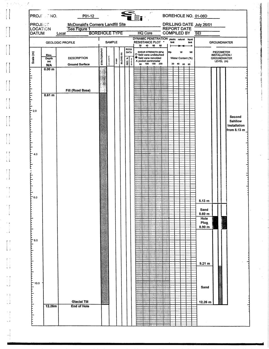
57 ANNUAL REPORT 2012 HYDROGEOLOGICAL ASSESSMENT MCDONALD S CORNERS WASTE DISPOSAL SITE APPENDIX D Borehole and Monitoring Well Instrumentation Logs (on CD) Project No.:
58
59
60
61
62
63
64
65
66
67
68
69

70

71

72

73

74

75
76

77

78
79
80
81

82
83
84
85
86
87
88
89 ANNUAL REPORT 2012 HYDROGEOLOGICAL ASSESSMENT MCDONALD S CORNERS WASTE DISPOSAL SITE APPENDIX E Provisional Certificate of Approval No Project No.:


90


91
92


93


94

95

96


97


98

99


100
101

102

103

104
105 ANNUAL REPORT 2012 HYDROGEOLOGICAL ASSESSMENT MCDONALD S CORNERS WASTE DISPOSAL SITE APPENDIX F Selected Correspondence between the Ministry of the Environment, Totten Sims Hubicki Associates and the Township of Lanark Highlands (on CD) Project No.:
106
107
108
109
110
111 Totten Sims Hubicki Associates 654 Norris Court Kingston, Ontario, Canada K7P 2R9 (613) Fax: (613) September 27, 2007 Mr. Greg Davis Senior Environmental Officer Ministry of the Environment Ottawa District Office 2430 Don Reid Dr Ottawa, ON, K1H 1E1 Dear Mr. Davis: Re: MacDonalds Corners Waste Disposal Site Certificate of Approval No. A Township of Lanark Highlands TSH Project No The following is in response to your site inspection report dated September 17, 2007 and cover letter of September 18, Groundwater monitoring at MacDonalds Corners Waste Disposal Site has been once annually since 2005 as approved by the Ministry of the Environment. Ministry approval was confirmed in you letter of April 8, 2005 to Mr. Tim Simpson at the Township (copy attached). Please advise if we are to disregard your earlier approval. Operational issues, such as the untagged refrigeration equipment, have been dealt with by Township staff. Yours very truly, Guy Laporte, P.Eng. Manager, Kingston Office GL/ss E:\PROJECTS\ Lanark Highlands WDS 2007\ McDonalds Corners WDS 2007\02- Correspondence\27Sep07 davis ltr.doc pc: Tim Simpson, Township of Lanark Highlands Jacques Sauriol, Jacques Whitford
112 Greg Davis, MOE Ottawa District 2 September 21, 2007
113
114
115
116
117
118
119 Totten Sims Hubicki Associates 654 Norris Court Kingston, Ontario, Canada K7P 2R9 (613) Fax: (613) January 2, 2008 Mr. Tim Simpson, CAO Township of Lanark Highlands 75 George Street, PO Box 340 Lanark, ON K0G 1K0 - by - Dear Mr. Simpson: Re: McDonalds Corners Waste Disposal Site Certificate of Approval No. A Township of Lanark Highlands TSH Project No I have discussed Bob Holland s review of Jacques Whitford s 2006 Annual Monitoring Report with Jacques Sauriol (Holland to Davis, December 18, 2007). We offer the following in response: 1. The current groundwater monitoring program at McDonalds Corners Waste Disposal Site has been approved by the Director. We do not propose any changes. 2. Sampling is once per year in the fall. If fall samples indicate trigger parameters have been exceeded then confirmatory samples would be collected the following spring. 3. Additional surveying and mapping will be undertaken in 2008 to better define on site surface water features. Further detail regarding the above will be in the 2007 Annual Report. A through review of surface water features will be included in the 2008 Annual Report. You should forward a copy of this letter to Greg Davis if you are in agreement with the proposed action. Yours very truly, Guy Laporte, P. Eng. Kingston Branch Manager GL/CW E:\PROJECTS\ Lanark Highlands WDS 2007\ Robertson Lake WDS 2007\02- Correspondence\14sept07 simpson eltr.doc pc: Jacques Sauriol, Jacques Whitford Inc.
120 Tim Simpson, Township of Lanark Highlands 2 September 14, 2007
121
122
123
124
125
126
127
128
129
130
131
132 Ministry of the Environment Ministère de l'environnement P.O. Box C.P Kingston, Ontario Kingston (Ontario) K7M 8S5 K7M 8S5 613/ or 1-800/ / ou 1-800/ Fax: 613/ Fax: 613/ M E M O R A N D U M December 18, 2008 TO: FROM: RE: Greg Davis Sr. Environmental Officer Ottawa District Office Eastern Region Bob Holland Hydrogeologist Water Resources Unit Technical Support Section Eastern Region MacDonald=s Corners Landfill 2007 Annual Monitoring Report Municipality of Lanark Highlands Certificate of Approval # A Hydrogeological Assessment Purpose I have completed my review of the AFinal Report 2007 Annual Report Hydrogeological Assessment McDonald s Corners Waste Disposal Site, Township of Lanark Highlands prepared by Jacques Whitford (JW) in March 2008". The JW report forms Appendix AB@ of the 2006 Annual Report prepared by Tottem Sims Hubicki Associates prepared March The purpose of my hydrogeological review is to determine compliance with Ministry Guideline B-7. Since this is a large landfill (i.e. total waste volume >40,000 m 3 ) I also make reference to Ont. Reg and Landfill Standards a Guideline on the Regulatory and Approval Requirements for New or Expanding Landfilling Sites May Summary $ The Mcdonald=s Corner Landfill complies with Guideline B-7. $ The vertical and horizontal extent of the landfill leachate plume has been adequately explored in the overburden and shallow bedrock aquifers. $ The primary pathway of leachate is eastward in the overburden aquifer and downward into two bedrock plumes which extend to the south and east of the waste fill area in the bedrock aquifer. Landfill leachate impacts are greater on the bedrock aquifer.
133 - 2 - $ The potential for direct discharge of leachate impacted groundwater to surface water exists. Future JW reports must better define the nature of surface water bodies at the site and how it relates to leachate impacted groundwater. Landfill leachate impacted groundwater is conveyed southward in the overburden aquifer and southeastward in a more radial pattern in the bedrock aquifer. Ministry Guideline B-1-2 Water Management Policies, Guidelines Provincial Water Quality Objectives, July 1994 otherwise known as the Blue Book states that: Provincial Water Quality Objectives (PWQO) are numerical and narrative criteria which serve as chemical and physical indicators representing a satisfactory level for surface waters (i.e. lakes and rivers) and, where it discharges to the surface, the groundwater of the Province. The PWQO are set at a level of water quality which is protective of all forms of aquatic life and all aspects of the aquatic life cycles during indefinite exposure to the water. The Objectives for protection of recreational water uses are based on public health and aesthetic considerations. Monitoring wells that intersect leachate impacted groundwater that ultimately discharges to surface water should be analyzed for the same suite of parameters as a surface water station and be assessed against PWQOs. Where groundwater is discharging to surface water and is found not to meet PWQOs, an assessment of potential surface water impact should be completed to determine if mitigation measures are required. $ In 2008 JW will sample for parameters listed Column 2 of the Landfill Standards a Guideline on the Regulatory and Approvals Requirements for New and Expanded Landfilling Sites May 1998 including potassium, manganese and TKN will be sampled as per my previous request. I agree with the consultant that VOC should be resampled at to further assess the 2007 results which indicated vinyl chloride levels slightly above the ODWQS. $ The proposed groundwater trigger is acceptable. The Contingency Plan for site is acceptable. $ Measure should be taken by the owner to ensure that explosive gas levels at the property boundary stay below 2.5 % methane gas in the subsurface at the property boundary in keeping with the general intent of Section 4.10 of the Ministry s Landfill Standards a Guideline on the Regulatory and Approvals Requirements for New and Expanded Landfilling Sites May I also recommend immediate notification of the Ministry and local fire officials if any of these limits are exceeded. Certificate of Approval The existing site has a total site area of 40 ha of which 1.5 ha is approved to accept 22,000 cubic metres of domestic waste. The original September, 1982 application mentions a 2.7 ha total site area which was subsequently amended to 40 ha. The proposed site expansion involves
134 - 3 - establishing a 2.8 ha waste footprint within a 40 ha site. Total waste to be landfilled is 62,000 cubic metres (82,000cubic metres including final cover). The site expansion involves an increase of 40,000 cubic metres of municipal solid waste. Geology The site is characterized by glacial till up to 3 m, but typically less than < 1 m, overlying metasedimentary and metavolcanic bedrock. Marble bedrock exists beneath the proposed expanded 2.8 ha waste footprint. Hydrogeological Conditions The physical hydrogeology of both the overburden and bedrock aquifers have now been generally defined horizontally and vertically to the extent that predictions and assessments of future off-site impacts can be made to determine compliance with Guideline B-7. Hydraulic Conductivity Past reports note hydraulic conductivities in the range of 10-5 cm/sec in bedrock with estimated pore water velocities ranging from 10 and 1000 cm/yr. Pore water velocities were estimated to range from 10 to 100 cm/yr in the overburden. Horizontal Hydraulic Gradient Some of the horizontal gradients measured in 2007 and ranged between m/m and m/m in the overburden aquifer and between m/m and m/m in the bedrock aquifer. Vertical Gradient Vertical gradients in 2007 were downward around the fill area and north of it. Upward gradients were measured south of the fill area at distal stations. Groundwater Flow Direction Groundwater flow in the overburden aquifer is southward. Groundwater flow in the shallow bedrock aquifer is to the south and east (i.e. radial flow). Hydrostratigraphic Units An overburden and shallow bedrock aquifer exist at this site. Conceptual Model Landfill leachate impact exists in both the overburden and bedrock aquifers. The JW report maps landfill leachate plume using isochem contours. This mapping indicates an overburden
135 - 4 - landfill leachate plume to the east of the site. Two landfill leachate plume have been mapped in the bedrock aquifer. These two plumes extend to the south and east of the waste fill area. Landfill leachate impacts are greater on the bedrock aquifer. Background Water Quality Groundwater quality samples collected at Monitoring Well and BH 2 are used to establish background water quality of the overburden and bedrock aquifer, respectively. This large landfill is subject to Ont. Regulation. Page 38 of the Landfill Standards a Guideline on the Regulatory and Approval Requirements for New or Expanding Landfilling Sites states that the background concentration of a contaminant in the groundwater of the receptor aquifer is the median value for that contaminant based on all groundwater samples taken from the receptor aquifer.... A minimum of five samples should be used to calculate a median value. This approach is now being used to calculate background water quality. Leachate Water Quality Leachate Indicator Parameters Monitoring Well is located in the overburden within the waste mound. There is no bedrock monitoring well within the waste mound, however, Monitoring Well is located directly down gradient and close to the waste mound. The water quality in these two monitoring wells is representative of leachate. Boron, chloride, sodium, barium, and TDS have been selected by JW as leachate indicator parameters. Down Gradient Water Quality Leachate impacts are evident in the following monitoring wells: overburden wells 01-01, 01-02, 01-07, and 01-06; and bedrock wells 00-03, 00-01, Groundwater/Surface Water Interactions The potential for direct discharge of leachate impacted groundwater to surface water exists. In 2008 the consultant will better define the nature and extent of the surface water features on site how these features relate to the site and its environs. Guideline B-7 The site currently complies with Guideline B-7.
136 - 5 - Groundwater Monitoring and Groundwater Trigger An adequate array of overburden and bedrock wells exists at present to determine background groundwater quality, leachate characterization, and down gradient leachate impacts. Two compliance monitoring wells, both dual level, have been constructed although they are both some distance from site boundaries. The groundwater trigger wells are 03-01SD and south 03-02SD which if triggered will cause the construction of additional wells further down gradient to track potential leachate progression towards the property boundaries. A three tier Contingency Plan has been proposed based on specific trigger parameters, namely CL, Na, B, Ba, TDS, and confirmatory sampling. In 2008 samples will be collected for all of the Column 2 Schedule 5 Landfill Standards a Guideline on the Regulatory and Approvals Requirements for New and Expanded Landfilling Sites May 1998 as well as potassium, manganese, and TKN. The consultant has recognized the need for further VOCs follow up sampling at in I agree. Landfill Gas Section 4.10 of the Landfill Standards a Guideline on the Regulatory and Approvals Requirements for New and Expanded Landfilling Sites May 1998 sets out concentration limits for methane gas in the subsurface at the property boundary, onsite buildings/foundations, and off-site buildings/foundations. There is no assessment of landfill gas at this site. Original signed by Robert Holland, P.Geo. RWH/gl c: Paul Kehoe Bruce Metcalfe Frank Crossley GW 03 03, LNHI, MacDonald s Corners Landfill (A451403) Bob Holland
137 Ministry of the Environment Ministère de l'environnement P.O. Box C.P Kingston, Ontario Kingston (Ontario) K7M 8S5 K7M 8S5 613/ or 1-800/ / ou 1-800/ Fax: 613/ Fax: 613/ M E M O R A N D U M 03 February 2009 TO: FROM: RE: G. Davis Senior Environmental Officer Ottawa District Office Eastern Region B. W. Metcalfe Senior Environmental Officer (Surface Water) Technical Support Section Eastern Region 2007 Annual Report McDonald s Corners Waste Disposal Site Lot 8, Concession 9 (geographic Township of Dalhousie) Township of Lanark Highlands Certificate of Approval No. A I have reviewed the noted report dated March 2008 prepared by Totten Sims Hubicki Associates (TSH) for the Township of Lanark Highlands. Jacques Whitford Limited (JWL) provided the 2007 Annual Report, Hydrogeological Assessment, McDonald s Corners Waste Disposal Site (March 2007) which was presented in Appendix B of the TSH report. The following comments are offered relative to surface water impact concerns. Background Information The site is located on Lot 8, Concession 9 within the geographic Township of Dalhousie, Township of Lanark Highlands. The site consists of an approved landfill area of 2.8 ha within a total area of 40 ha. The site is bounded by County Road 12 to the north, and undeveloped land to the west, south and east. The current landfill site replaced an existing dump in 1983, which is located on adjacent lands to the west. The site operates under Certificate of Approval No. A and is licensed to receive solid non-hazardous municipal, industrial, commercial and institutional waste. Waste is disposed of at the landfill site employing area fill method and the site operates as a natural attenuating landfill. TSH reported there were no operational issues encountered for the landfill site in 2007.
138 - 2 - Surface Water Regime The area surface water hydrology has been described to flow easterly and south-westerly, east and west of the site respectively. The downgradient surface water regime includes a marsh originating east of the landfill site and Jackman s Creek (Mississippi River Basin) drains from the marsh. The area surface water courses ultimately flow into Dalhousie Lake (Mississippi River Basin) located approximately 1.5 km north of the landfill site. The site area is understood to be relatively well drained with the exception of the seasonally wet low lying area located south and east of the active landfill. The 2002 and 2003 hydrogeological assessment analytical data indicated three plumes leaving the waste pile, with two groundwater impacted plumes within the bedrock aquifer to the south and east of the fill area, and one plume within the overburden east of the landfill. JWL has further determined that horizontal gradients within the overburden in for the fall are indicative of southerly flow south of the landfill. JWL has identified boron, sodium, chloride, barium, and total dissolved solids to be key leachate indicators for the McDonald s Corners WDS Surface Water Sampling Program Surface water samples were collected by JWL on one occasion during June Surface water sample locations monitored during June 2007 included stations SW-1 to SW-5 and it was noted that sample station SW-2 was reported Dry. A second attempt was made by JWL to collect samples in October 2007 but all surface water sample stations were reported Dry. It is the reviewer s understanding that site area surface water regime conditions are such that there is no upstream background surface water station for the purposes of water quality impact assessment. There are inconsistencies in the consultant s identified location of sample station SW-5 being reported be both upstream and downstream of the site. It is the reviewer s understanding that sample station SW-5 is downstream of the landfill site. Surface water samples were analyzed for BOD, COD, alkalinity, Hardness, chloride, total suspended solids, total ammonia, un-ionized ammonia, total nitrates, total phosphorus, phenols, and metals: aluminum, boron, copper, cobalt, iron, manganese and zinc Surface Water Sampling Results A review of the surface water quality data summary for the June 2007 sampling event showed the following general chemistry water quality characterization: SW1 (south of Site) BOD5 (19 mg/l), COD (175 mg/l), Conductivity (1055µS/cm), Chloride (61mg/L), TSS (156 mg/l), ph (7.04), Alkalinity (507 mg/l), Hardness (526 mg/l), Total Ammonia (2.57 mg/l), Un-ionized Ammonia (<0.01 mg/l), and Total Phosphorus (0.57mg/L).
139 - 3 - PWQO exceedance occurred for boron (0.34 mg/l, exceeded mg/l), cobalt ( mg/l, exceeded mg/l), total phosphorus (0.57 mg/l, exceeded mg/l), phenols (0.014 mg/l, exceeded mg/l), and dissolved oxygen (3.8 mg/l, less than 4.0 mg/l). The reviewer would note that the concentrations for BOD5, Conductivity, Hardness, Total Phosphorus, and Total Suspended Solids were significantly high for natural water unimpacted surface water quality. SW2 (south of Site) Sample station Dry for the 2007 June & October monitoring events. SW3 (east of Site) BOD5 (19 mg/l), COD (152 mg/l), Conductivity (1010 µs/cm), Chloride (37mg/L), TSS (50 mg/l), ph (7.61), Alkalinity (596 mg/l), Hardness (599 mg/l), Total Ammonia (2.1mg/L), Un-ionized Ammonia (<0.1 mg/l), and Total Phosphorus (0.33mg/L). PWQO exceedance occurred for boron (0.612 mg/l, exceeded 0.20 mg/l), cobalt ( mg/l, exceeded mg/l), iron (2.58 mg/l, exceeded 0.30 mg/l), zinc (12 mg/l, significantly exceeded mg/l), phenols (0.037 mg/l, exceeded mg/l), and dissolved oxygen (3.3 mg/l, less than 4.0 mg/l). The reviewer would note that the concentrations for BOD5, Conductivity, Hardness, Total Phosphorus, and Total Suspended Solids were significantly high for natural water unimpacted surface water quality. The reviewer would note that the reported zinc concentration of 12 mg/l would appear to be abnormally high and may in fact be an erroneous value and this should be confirmed by the landfill site Owner. The reviewer would note that the un-ionized ammonia concentration (a calculated value employing the total ammonia concentration, ambient surface water temperature and ph data) was reported as <0.1 mg/l, the reviewer would note that un-ionized ammonia concentrations are to be compared relative to the PWQO of 0.02 mg/l. SW4 (north of Site) ) BOD5 (21 mg/l), COD (303 mg/l), Conductivity (403 µs/cm), Chloride (2 mg/l), TSS (338 mg/l), ph (7.75), Alkalinity (219 mg/l), Hardness (264 mg/l), Total Ammonia (0.07 mg/l), Un-ionized Ammonia (<0.1 mg/l), and Total Phosphorus (0.33mg/L). PWQO exceedance occurred for iron (0.373 mg/l, slightly exceeded 0.30 mg/l), Zinc (0.218 mg/l, exceeded mg/l), Total Phosphorus (0.33 mg/l, exceeded mg/l), and phenols (0.009 mg/l, exceeded mg/l). The reviewer would note that the BOD5 concentration was significantly high for natural unimpacted surface water quality. Overall the majority of parameters exhibited lower concentrations than at surface water sampling locations SW1, SW2, and SW3 for the June 2007 sampling event.
140 - 4 - SW5 (Jackman s Creek, north of Site) - BOD5 (< 2 mg/l), COD (41 mg/l), Conductivity (738 µs/cm), Chloride (63 mg/l), TSS (< 2 mg/l), ph (7.81), Alkalinity (336 mg/l), Hardness (376 mg/l), Total Ammonia (0.03 mg/l), Un-ionized Ammonia (<0.1 mg/l), and Total Phosphorus (0.02 mg/l). PWQO exceedance occurred for only iron (0.33 mg/l, slightly exceeded 0.30 mg/l) Surface Water Impact Assessment JWL identified that overall the PWQO exceedance were limited to Boron (SW-1 & SW-3), Total Phosphorus (SW-1, SW-3, and SW-4) and Phenols (SW-1, SW-3, and SW-4). JWL reported there was no PWQO exceedance reported at the Jackman s Creek downstream sample station SW-5. JWL identified that historically samples tested from surface water monitoring stations southwest and east of the active site have regularly exceeded the PWQO for un-ionized ammonia, total phosphorus, boron, and phenols during both the spring and fall monitoring events. JWL further reported that surface water samples obtained from Jackman s Creek downstream of the landfill site off-site have historically been in compliance with PWQO. The reviewer would note that for the 2007 sampling events JWL did not identify PWQO exceedance for cobalt (SW1 & SW3), iron (SW3, SW4, and SW5), zinc (SW3 & SW4), and dissolved oxygen (SW1 & SW3). It is the reviewer s considered assessment that the concentrations for BOD5, Conductivity, Hardness, Total Phosphorus, and Total Suspended Solids were notably significantly high at SW1, SW3 for natural water un-impacted surface water quality, and that BOD5 concentration at sample station SW4 was also significantly high. It is the reviewer s assessment that the surface water quality at downgradient sample locations SW1 and SW3 appear to be impacted by landfill site leachate sources. Recommendations 1. Reference is made in Section 1.5 Ministry of the Environment Correspondence of the TSH Report to selected correspondence between the MOE, TSH and the Township of Lanark Highlands and which was presented in Appendix G of the report. The reviewer would note that comments pertinent to surface water impact concerns were provided relative to the 2006 Annual Report for the McDonald s Corners WDS (TSH, March 2007) in the reviewer s memorandum dated November 9, 2007 from B. Metcalfe, Senior Environmental Officer, Technical Support Section, Eastern Region to G. Davis, Senior Environmental Officer, Ottawa District Office, Eastern Region. The reviewer s comments and recommendations as provided in the November 9, 2007 memorandum remain relevant for the McDonald s Corners WDS. It would be anticipated that the surface water reviewer s concerns and
141 - 5 - recommendations will have been appropriately addressed by the landfill site Owner during the 2008 sampling year and will be presented in the associated Annual Report for the McDonald s Corners WDS. 2. JWL noted that additional surveying and mapping of on-site surface water features, as well as detailed descriptions and photos of each surface water monitoring location will be undertaken as part of the 2008 work program. 3. JWL identified PWQO exceedance at both SW-1 and SW-3 for boron, total phosphorus and phenols. The consultant recommended that the apparent surface water quality impact close to the landfill site s western property boundary should be confirmed in the 2008 surface water sampling program for the landfill site. 4. The reviewer would note that for the 2007 sampling events JWL did not identify PWQO exceedance for cobalt (SW1 & SW3), iron (SW3, SW4, and SW5), zinc (SW3 & SW4), and dissolved oxygen (SW1 & SW3). The reviewer would note that the reported zinc concentration of 12 mg/l at SW3 would appear to be abnormally high and may in fact be an erroneous value and this should be confirmed by the landfill site Owner. 5. With regard to un-ionized ammonia concentration determination, the reviewer would note that the un-ionized ammonia concentration was reported as <0.1 mg/l. It is the reviewer s assumption that the calculated un-ionized ammonia fraction was determined by the consultant employing ambient field surface water temperature and ph data. Un-ionized ammonia concentrations should be appropriately compared to the PWQO of 0.02 mg/l. e.g., the landfill site Owner provide confirmation that un-ionized ammonia concentrations are less than the PWQO of 0.02 mg/l. 6. JWL recommended that a new surface water sampling station be established further downstream of SW-1 in order to assess compliance along the south-western property boundary. The reviewer has no objection to the addition of another surface water sample station downstream of sample station SW-1. The reviewer would emphasize that application of surface water PWQO is not contingent to the site property boundaries, dependant on the location of the potentially affected surface water feature and the requirement to protect downstream water quality it is appropriate to apply PWQOs both on-site as well as off-site the waste disposal site property. 7. There are inconsistencies in the 2007 Annual Report regarding the consultant s identified strategic location of surface water sample station SW-5 being reported to be both upstream and downstream of the site. The reviewer requests that the location of surface water sample station SW-5 be confirmed by the landfill site Owner. Bruce Metcalfe BWM/gl
142 - 6 - c: R. Holland P. Kehoe B. Metcalfe (Aba2009\aba0909.mem) J4NBA File SW 05-04, McDonald s Corners WDS, Township of Lanark Highlands File SW , Dalhousie Lake, Mississippi River Basin ec: P. Taylor
143
144
145
146
147
148


149


150

151

152

153

154

155 Ministry of the Environment Ministère de l'environnement P.O. Box C.P Kingston, Ontario Kingston (Ontario) K7M 8S5 K7M 8S5 613/ or 1-800/ / ou 1-800/ Fax: 613/ Fax: 613/ M E M O R A N D U M December 18, 2008 TO: FROM: RE: Greg Davis Sr. Environmental Officer Ottawa District Office Eastern Region Bob Holland Hydrogeologist Water Resources Unit Technical Support Section Eastern Region MacDonald=s Corners Landfill 2007 Annual Monitoring Report Municipality of Lanark Highlands Certificate of Approval # A Hydrogeological Assessment Purpose I have completed my review of the AFinal Report 2007 Annual Report Hydrogeological Assessment McDonald s Corners Waste Disposal Site, Township of Lanark Highlands prepared by Jacques Whitford (JW) in March 2008". The JW report forms Appendix AB@ of the 2006 Annual Report prepared by Tottem Sims Hubicki Associates prepared March The purpose of my hydrogeological review is to determine compliance with Ministry Guideline B-7. Since this is a large landfill (i.e. total waste volume >40,000 m 3 ) I also make reference to Ont. Reg and Landfill Standards a Guideline on the Regulatory and Approval Requirements for New or Expanding Landfilling Sites May Summary $ The Mcdonald=s Corner Landfill complies with Guideline B-7. $ The vertical and horizontal extent of the landfill leachate plume has been adequately explored in the overburden and shallow bedrock aquifers. $ The primary pathway of leachate is eastward in the overburden aquifer and downward into two bedrock plumes which extend to the south and east of the waste fill area in the bedrock aquifer. Landfill leachate impacts are greater on the bedrock aquifer.
156 - 2 - $ The potential for direct discharge of leachate impacted groundwater to surface water exists. Future JW reports must better define the nature of surface water bodies at the site and how it relates to leachate impacted groundwater. Landfill leachate impacted groundwater is conveyed southward in the overburden aquifer and southeastward in a more radial pattern in the bedrock aquifer. Ministry Guideline B-1-2 Water Management Policies, Guidelines Provincial Water Quality Objectives, July 1994 otherwise known as the Blue Book states that: Provincial Water Quality Objectives (PWQO) are numerical and narrative criteria which serve as chemical and physical indicators representing a satisfactory level for surface waters (i.e. lakes and rivers) and, where it discharges to the surface, the groundwater of the Province. The PWQO are set at a level of water quality which is protective of all forms of aquatic life and all aspects of the aquatic life cycles during indefinite exposure to the water. The Objectives for protection of recreational water uses are based on public health and aesthetic considerations. Monitoring wells that intersect leachate impacted groundwater that ultimately discharges to surface water should be analyzed for the same suite of parameters as a surface water station and be assessed against PWQOs. Where groundwater is discharging to surface water and is found not to meet PWQOs, an assessment of potential surface water impact should be completed to determine if mitigation measures are required. $ In 2008 JW will sample for parameters listed Column 2 of the Landfill Standards a Guideline on the Regulatory and Approvals Requirements for New and Expanded Landfilling Sites May 1998 including potassium, manganese and TKN will be sampled as per my previous request. I agree with the consultant that VOC should be resampled at to further assess the 2007 results which indicated vinyl chloride levels slightly above the ODWQS. $ The proposed groundwater trigger is acceptable. The Contingency Plan for site is acceptable. $ Measure should be taken by the owner to ensure that explosive gas levels at the property boundary stay below 2.5 % methane gas in the subsurface at the property boundary in keeping with the general intent of Section 4.10 of the Ministry s Landfill Standards a Guideline on the Regulatory and Approvals Requirements for New and Expanded Landfilling Sites May I also recommend immediate notification of the Ministry and local fire officials if any of these limits are exceeded. Certificate of Approval The existing site has a total site area of 40 ha of which 1.5 ha is approved to accept 22,000 cubic metres of domestic waste. The original September, 1982 application mentions a 2.7 ha total site area which was subsequently amended to 40 ha. The proposed site expansion involves
157 - 3 - establishing a 2.8 ha waste footprint within a 40 ha site. Total waste to be landfilled is 62,000 cubic metres (82,000cubic metres including final cover). The site expansion involves an increase of 40,000 cubic metres of municipal solid waste. Geology The site is characterized by glacial till up to 3 m, but typically less than < 1 m, overlying metasedimentary and metavolcanic bedrock. Marble bedrock exists beneath the proposed expanded 2.8 ha waste footprint. Hydrogeological Conditions The physical hydrogeology of both the overburden and bedrock aquifers have now been generally defined horizontally and vertically to the extent that predictions and assessments of future off-site impacts can be made to determine compliance with Guideline B-7. Hydraulic Conductivity Past reports note hydraulic conductivities in the range of 10-5 cm/sec in bedrock with estimated pore water velocities ranging from 10 and 1000 cm/yr. Pore water velocities were estimated to range from 10 to 100 cm/yr in the overburden. Horizontal Hydraulic Gradient Some of the horizontal gradients measured in 2007 and ranged between m/m and m/m in the overburden aquifer and between m/m and m/m in the bedrock aquifer. Vertical Gradient Vertical gradients in 2007 were downward around the fill area and north of it. Upward gradients were measured south of the fill area at distal stations. Groundwater Flow Direction Groundwater flow in the overburden aquifer is southward. Groundwater flow in the shallow bedrock aquifer is to the south and east (i.e. radial flow). Hydrostratigraphic Units An overburden and shallow bedrock aquifer exist at this site. Conceptual Model Landfill leachate impact exists in both the overburden and bedrock aquifers. The JW report maps landfill leachate plume using isochem contours. This mapping indicates an overburden
158 - 4 - landfill leachate plume to the east of the site. Two landfill leachate plume have been mapped in the bedrock aquifer. These two plumes extend to the south and east of the waste fill area. Landfill leachate impacts are greater on the bedrock aquifer. Background Water Quality Groundwater quality samples collected at Monitoring Well and BH 2 are used to establish background water quality of the overburden and bedrock aquifer, respectively. This large landfill is subject to Ont. Regulation. Page 38 of the Landfill Standards a Guideline on the Regulatory and Approval Requirements for New or Expanding Landfilling Sites states that the background concentration of a contaminant in the groundwater of the receptor aquifer is the median value for that contaminant based on all groundwater samples taken from the receptor aquifer.... A minimum of five samples should be used to calculate a median value. This approach is now being used to calculate background water quality. Leachate Water Quality Leachate Indicator Parameters Monitoring Well is located in the overburden within the waste mound. There is no bedrock monitoring well within the waste mound, however, Monitoring Well is located directly down gradient and close to the waste mound. The water quality in these two monitoring wells is representative of leachate. Boron, chloride, sodium, barium, and TDS have been selected by JW as leachate indicator parameters. Down Gradient Water Quality Leachate impacts are evident in the following monitoring wells: overburden wells 01-01, 01-02, 01-07, and 01-06; and bedrock wells 00-03, 00-01, Groundwater/Surface Water Interactions The potential for direct discharge of leachate impacted groundwater to surface water exists. In 2008 the consultant will better define the nature and extent of the surface water features on site how these features relate to the site and its environs. Guideline B-7 The site currently complies with Guideline B-7.
159 - 5 - Groundwater Monitoring and Groundwater Trigger An adequate array of overburden and bedrock wells exists at present to determine background groundwater quality, leachate characterization, and down gradient leachate impacts. Two compliance monitoring wells, both dual level, have been constructed although they are both some distance from site boundaries. The groundwater trigger wells are 03-01SD and south 03-02SD which if triggered will cause the construction of additional wells further down gradient to track potential leachate progression towards the property boundaries. A three tier Contingency Plan has been proposed based on specific trigger parameters, namely CL, Na, B, Ba, TDS, and confirmatory sampling. In 2008 samples will be collected for all of the Column 2 Schedule 5 Landfill Standards a Guideline on the Regulatory and Approvals Requirements for New and Expanded Landfilling Sites May 1998 as well as potassium, manganese, and TKN. The consultant has recognized the need for further VOCs follow up sampling at in I agree. Landfill Gas Section 4.10 of the Landfill Standards a Guideline on the Regulatory and Approvals Requirements for New and Expanded Landfilling Sites May 1998 sets out concentration limits for methane gas in the subsurface at the property boundary, onsite buildings/foundations, and off-site buildings/foundations. There is no assessment of landfill gas at this site. Original signed by Robert Holland, P.Geo. RWH/gl c: Paul Kehoe Bruce Metcalfe Frank Crossley GW 03 03, LNHI, MacDonald s Corners Landfill (A451403) Bob Holland
160 Totten Sims Hubicki Associates 654 Norris Court Kingston, Ontario, Canada K7P 2R9 (613) Fax: (613) January 2, 2008 Mr. Tim Simpson, CAO Township of Lanark Highlands 75 George Street, PO Box 340 Lanark, ON K0G 1K0 - by - Dear Mr. Simpson: Re: McDonalds Corners Waste Disposal Site Certificate of Approval No. A Township of Lanark Highlands TSH Project No I have discussed Bob Holland s review of Jacques Whitford s 2006 Annual Monitoring Report with Jacques Sauriol (Holland to Davis, December 18, 2007). We offer the following in response: 1. The current groundwater monitoring program at McDonalds Corners Waste Disposal Site has been approved by the Director. We do not propose any changes. 2. Sampling is once per year in the fall. If fall samples indicate trigger parameters have been exceeded then confirmatory samples would be collected the following spring. 3. Additional surveying and mapping will be undertaken in 2008 to better define on site surface water features. Further detail regarding the above will be in the 2007 Annual Report. A through review of surface water features will be included in the 2008 Annual Report. You should forward a copy of this letter to Greg Davis if you are in agreement with the proposed action. Yours very truly, Guy Laporte, P. Eng. Kingston Branch Manager GL/CW E:\PROJECTS\ Lanark Highlands WDS 2007\ Robertson Lake WDS 2007\02- Correspondence\14sept07 simpson eltr.doc pc: Jacques Sauriol, Jacques Whitford Inc.
161 Tim Simpson, Township of Lanark Highlands 2 September 14, 2007

162 Totten Sims Hubicki Associates 654 Norris Court Kingston, Ontario, Canada K7P 2R9 (613) Fax: (613) September 27, 2007 Mr. Greg Davis Senior Environmental Officer Ministry of the Environment Ottawa District Office 2430 Don Reid Dr Ottawa, ON, K1H 1E1 Dear Mr. Davis: Re: MacDonalds Corners Waste Disposal Site Certificate of Approval No. A Township of Lanark Highlands TSH Project No The following is in response to your site inspection report dated September 17, 2007 and cover letter of September 18, Groundwater monitoring at MacDonalds Corners Waste Disposal Site has been once annually since 2005 as approved by the Ministry of the Environment. Ministry approval was confirmed in you letter of April 8, 2005 to Mr. Tim Simpson at the Township (copy attached). Please advise if we are to disregard your earlier approval. Operational issues, such as the untagged refrigeration equipment, have been dealt with by Township staff. Yours very truly, Guy Laporte, P.Eng. Manager, Kingston Office GL/ss E:\PROJECTS\ Lanark Highlands WDS 2007\ McDonalds Corners WDS 2007\02- Correspondence\27Sep07 davis ltr.doc pc: Tim Simpson, Township of Lanark Highlands Jacques Sauriol, Jacques Whitford
163 Greg Davis, MOE Ottawa District 2 September 21, 2007
164
165
166
167
168


169
170
171
172
173
174
175
176
177
178
179
180 ANNUAL REPORT 2012 HYDROGEOLOGICAL ASSESSMENT MCDONALD S CORNERS WASTE DISPOSAL SITE APPENDIX G 2012 Surface Water and Monitoring Well Photo Log Project No.:


181 Photo G1: Surface Water Station SW-1, May Photo G2: Surface Water Station SW-2, May Project No:


182 Photo G3: Surface Water Station SW-3, May Photo G4: Surface Water Station SW-4, May Project No:


183 Photo G5: Surface Water Station SW-5, May Photo G6: Surface Water Station SW-6, May Project No:
TOWNSHIP OF NORTH GLENGARRY MAXVILLE COMMUNAL SEWAGE LAGOONS 2011 GROUNDWATER AND SURFACE WATER MONITORING PROGRAM REF.: FINAL REPORT
 2011 Groundwater and Surface Water Monitoring Program FINAL REPORT TOWNSHIP OF NORTH GLENGARRY MAXVILLE COMMUNAL SEWAGE LAGOONS 2011 GROUNDWATER AND SURFACE WATER MONITORING PROGRAM REF.: 09-511 Submitted:
APPENDIX I MONITORING AND SCREENING CHECKLIST
 APPENDIX I MONITORING AND SCREENING CHECKLIST Appendix D-Monitoring and Screening Checklist General Information and Instructions General Information: The checklist is to be completed, and submitted with
DROGHEDA LANDFILL SITE COLLON ROAD, MELL, DROGHEDA
 GROUNDWATER MONITORING INFORMATION QUARTERLY REPORT FOR PERIOD APRIL TO JUNE 216 BY LOUTH COUNTY COUNCIL TO ENVIRONMENTAL PROTECTION AGENCY FOR WASTE LICENCE REFERENCE: W33-1 DROGHEDA LANDFILL SITE COLLON
W12A Landfill Groundwater, Leachate, Water Well, Landfill Gas and Surface Water Quality Monitoring Program
 W12A Landfill Groundwater, Leachate, Water Well, Landfill Gas and Surface Water Quality Monitoring Program The groundwater, leachate, water well, landfill gas and surface water monitoring programs are
GROUNDWATER ASSESSMENT MONITORING REPORT APRIL 2014
 Tennessee Valley Authority John Sevier Fossil Plant GROUNDWATER ASSESSMENT MONITORING REPORT APRIL 2014 Prepared by Amos L. Smith, PG Chattanooga, Tennessee June 4, 2014 DOCUMENT CERTIFICATION I certify
Submitted to: Regional District of Central Okanagan 1450 KLO Road Kelowna, BC V1W 3Z4
 April 22, 2013 WESTSIDE LANDFILL, WEST KELOWNA, BC 2012 Annual Operations and Monitoring Report Submitted to: Regional District of Central Okanagan 1450 KLO Road Kelowna, BC V1W 3Z4 Attention: Chris Radford
FINAL 2018 Annual Monitoring Report Bark Lake Waste Disposal Site Township of Madawaska Valley, County of Renfrew, Ontario
 FINAL 2018 Annual Monitoring Report Bark Lake Waste Disposal Site Township of Madawaska Valley, County of Renfrew, Ontario Prepared for: Township of Madawaska Valley 85 Bay Street P.O Box 1000 Barry s
M E M O R A N D U M 10 June Senior Environmental Officer Ottawa District Office Eastern Region
 Ministry of the Environment Ministère de l'environnement P.O. Box 22032 C.P. 22032 Kingston, Ontario Kingston (Ontario) K7M 8S5 K7M 8S5 613/549-4000 or 1-800/267-0974 613/549-4000 ou 1-800/267-0974 Fax:
Livingston County Department of Public Health Environmental Health Division. Hydrogeologic Investigation Requirements for Land Division Developments
 Livingston County Department of Public Health Environmental Health Division Hydrogeologic Investigation Requirements for Land Division Developments Reviewed March 1, 2013 Table of Contents Scope/Authority..1
Submitted to: Ontario Clean Water Agency Attention: Mr. R. Eagle Georgian Bay Hub, Eastern Ontario Region 30 Woodland Drive Wasaga Beach, ON L9V 2V4
 March 2015 ENVIRONMENTAL MONITORING REPORT Snow Valley Landings Waste Water Treatment Plant Submitted to: Ontario Clean Water Agency Attention: Mr. R. Eagle Georgian Bay Hub, Eastern Ontario Region 30
ANNUAL GROUNDWATER MONITORING AND CORRECTIVE ACTION REPORT FOR 2018 JAMES RIVER POWER STATION (JRPS) Prepared for:
 Prepared for:") ANNUAL GROUNDWATER MONITORING AND CORRECTIVE ACTION REPORT FOR 2018 JAMES RIVER POWER STATION (JRPS) Prepared for: City Utilities of Springfield 301 E. Central Street Springfield, Missouri Prepared by:
ANNUAL GROUNDWATER MONITORING AND CORRECTIVE ACTION REPORT FOR 2018 JAMES RIVER POWER STATION (JRPS) Prepared for: City Utilities of Springfield 301 E. Central Street Springfield, Missouri Prepared by:
Phase II Environmental Site Assessment (ESA) Update. Bernard Benoit Project Management (BBPM) 2212 Gladwin Crescent, Unit B4 Ottawa, Ontario K1B 5N1
 Update. Bernard Benoit Project Management (BBPM) 2212 Gladwin Crescent, Unit B4 Ottawa, Ontario K1B 5N1") Phase II Environmental Site Assessment (ESA) Update 2720 Richmond Road Bernard Benoit Project Management (BBPM) 2212 Gladwin Crescent, Unit B4 K1B 5N1 Centre Multiservices Francophone de l Ouest d Ottawa
Phase II Environmental Site Assessment (ESA) Update 2720 Richmond Road Bernard Benoit Project Management (BBPM) 2212 Gladwin Crescent, Unit B4 K1B 5N1 Centre Multiservices Francophone de l Ouest d Ottawa
Fly Ash Testing Results PEI Energy Systems Waste Combustion Ash
 Fly Ash Testing Results PEI Energy Systems Waste Combustion Ash Job No. 121811835 Prepared for: PEI Energy Systems (Veresen Inc.) PO Box 271 Charlottetown PE C1A 9M2 Prepared by: Stantec Consulting Ltd.
MOE 2001 Terms of Reference
 February 17, 2015 Project No. 1405934-201 Mary McCuaig, CAO/Clerk Corporation of the Nation Municipality 958 Road 500 West, R.R. 3 Casselman, Ontario K0A 1M0 GUDI ASSESSMENT OF LIMOGES WELLS #3 AND #4,
Strength. Performance. Passion. Paris Pit CAP. April 30, Permit To Take Water Application Holcim (Canada) Inc.
 Inc.") Strength. Performance. Passion. Paris Pit CAP April 30, 2013 Permit To Take Water Application 2012 Holcim (Canada) Inc. Agenda Welcome Minutes from Last Meeting Dufferin Paris Pit - General Update Review
Strength. Performance. Passion. Paris Pit CAP April 30, 2013 Permit To Take Water Application 2012 Holcim (Canada) Inc. Agenda Welcome Minutes from Last Meeting Dufferin Paris Pit - General Update Review
FIRST ANNUAL COAL COMBUSTION RESIDUALS (CCR) GROUNDWATER MONITORING AND CORRECTIVE ACTION REPORT LANDFILL AND SURFACE IMPOUNDMENTS
 GROUNDWATER MONITORING AND CORRECTIVE ACTION REPORT LANDFILL AND SURFACE IMPOUNDMENTS") FIRST ANNUAL COAL COMBUSTION RESIDUALS (CCR) GROUNDWATER MONITORING AND CORRECTIVE ACTION REPORT LANDFILL AND SURFACE IMPOUNDMENTS R.D. MORROW, SR. GENERATING STATION 304 OLD OKAHOLA SCHOOL ROAD PURVIS,
FIRST ANNUAL COAL COMBUSTION RESIDUALS (CCR) GROUNDWATER MONITORING AND CORRECTIVE ACTION REPORT LANDFILL AND SURFACE IMPOUNDMENTS R.D. MORROW, SR. GENERATING STATION 304 OLD OKAHOLA SCHOOL ROAD PURVIS,
CONSTRUCTION AND DEMOLITION DEBRIS DISPOSAL SITE GUIDELINES
 Nova Scotia Environment and Labour CONSTRUCTION AND DEMOLITION DEBRIS DISPOSAL SITE GUIDELINES Approval Date: October 24, 1997 Effective Date: October 24, 1997 Approved By: Peter Underwood Version Control:
REGION OF PEEL PUBLIC WORKS DESIGN, SPECIFICATIONS & PROCEDURES MANUAL LINEAR INFRASTRUCTURE
 REGION OF PEEL PUBLIC WORKS DESIGN, SPECIFICATIONS & PROCEDURES MANUAL LINEAR INFRASTRUCTURE GUIDELINES FOR HYDROGEOLOGIC ASSESSMENT AND REPORTING REQUIREMENTS NEW DEVELOPMENTS ON MUNICIPAL SERVICES REVISED
RISK MANAGEMENT OF A FORMER SALT STORAGE YARD
 RISK MANAGEMENT OF A FORMER SALT STORAGE YARD Robert S. Nichols, B.Sc., P.Eng. and Trent Parks, Ph.D., P.Chem. Abstract A risk management plan was developed by Matrix Solutions Inc. (Matrix) and implemented
Technical Memorandum Groundwater Quality Sampling, First 2010 Semiannual Event
 Kennedy/Jenks Consultants Technical Memorandum Groundwater Quality Sampling, First 2010 Semiannual Event Date: 30 July 2010 To: From: Subject: Amy Blain City of Longview Steve Misner Kennedy/Jenks Consultants
INITIAL ANNUAL GROUNDWATER MONITORING AND CORRECTIVE ACTION REPORT
 Prepared For: Fort Armistead Road Lot 15 Landfill, LLC 1005 Brandon Shores Road, Suite 100 Baltimore, Maryland 21226 INITIAL ANNUAL GROUNDWATER MONITORING AND CORRECTIVE ACTION REPORT FEDERAL CCR RULE
McCann Solar Project Baseline Well Water Monitoring Program and Construction Response Plan July 8, 2011
 July 8, 2011 Northland Power Inc. on behalf of Northland Power Solar McCann L.P. Toronto, Ontario Baseline Well Water Monitoring Program and Construction Response Plan H334844-0000-07-124-0352 Rev. 1 July
Pebble Project Environmental Baseline Studies Technical Summary. APPENDIX A. Analytical Quality Assurance/Quality Control Review
 Pebble Project Environmental Baseline Studies 2004-2008 Technical Summary APPENDIX A. Analytical Quality Assurance/Quality Control Review TABLE OF CONTENTS TABLE OF CONTENTS... A-i ACRONYMS AND ABBREVIATIONS...A-ii
Holcim (Australia) Pty Limited. Lynwood Quarry Groundwater Monitoring Program Revision 2
 Pty Limited. Lynwood Quarry Groundwater Monitoring Program Revision 2") Holcim (Australia) Pty Limited Lynwood Quarry Groundwater Monitoring Program Revision 2 June 2011 Lynwood Quarry Groundwater Monitoring Program Revision 2 Prepared by on behalf of Holcim (Australia) Pty
Holcim (Australia) Pty Limited Lynwood Quarry Groundwater Monitoring Program Revision 2 June 2011 Lynwood Quarry Groundwater Monitoring Program Revision 2 Prepared by on behalf of Holcim (Australia) Pty
Groundwater Monitoring Requirements of the CCR Rule What s Next?
 2017 World of Coal Ash (WOCA) Conference in Lexington, KY - May 9-11, 2017 http://www.flyash.info/ Groundwater Monitoring Requirements of the CCR Rule What s Next? Thomas A. Mann, PE SynTerra Corporation,
May 2009 Semiannual Report
 Environment Submitted to: Submitted by: CNA Holdings, Inc. AECOM Dallas, Texas Atlanta, Georgia 60135443 November 2009 May 2009 Semiannual Report Needmore Road Landfill Facility Salisbury, North Carolina
GROUNDWATER MONITORING QUALITY ASSURANCE/QUALITY CONTROL PLAN LOWER YAKIMA VALLEY GWMA INITIAL CHARACTERIZATION
 GROUNDWATER MONITORING QUALITY ASSURANCE/QUALITY CONTROL PLAN LOWER YAKIMA VALLEY GWMA INITIAL CHARACTERIZATION September 16, 2013 GROUNDWATER MONITORING QUALITY ASSURANCE/QUALITY CONTROL PLAN LOWER YAKIMA
February 24, 2015 Reference: 298
 1297 Old Bridle Path Oakville, Ontario L6M 1A6 Tel: 905-825-8007 Fax: 905-825-9006 E-mail: geokamp@geokamp.com GEO KAMP LIMITED February 24, 2015 Reference: 298 MR. JOHN SPINA CALEDON VILLAS 55 BLUE WILLOW
QUARTER GROUNDWATER SAMPLING RESULTS FOR THE CENTRAL WASTE MANAGEMENT FACILITY (CWMF), BALLYDUFFBEG, INAGH, CO. CLARE.
, BALLYDUFFBEG, INAGH, CO. CLARE.") QUARTER 4 2015 GROUNDWATER SAMPLING RESULTS FOR THE CENTRAL WASTE MANAGEMENT FACILITY (CWMF), BALLYDUFFBEG, INAGH, CO. CLARE. Prepared for: CLARE COUNTY COUNCIL ARAS AN CHONTAE NEW ROAD ENNIS 3156 January
QUARTER 4 2015 GROUNDWATER SAMPLING RESULTS FOR THE CENTRAL WASTE MANAGEMENT FACILITY (CWMF), BALLYDUFFBEG, INAGH, CO. CLARE. Prepared for: CLARE COUNTY COUNCIL ARAS AN CHONTAE NEW ROAD ENNIS 3156 January
Report. Letter. t Monitoring FDEP. Semiannual. monitoring. data from. This letter Monitoring. previously. event has. monitoring
 September 1, 2014 Alex Webster, P.G Cleanup Section Supervisor Northwest District Florida Department of Environmental Protection 160 W. Government Street, Suite 308 Pensacola, Florida 32502-5740 Re: Wright
Technical Memorandum Groundwater Quality Sampling, November 2010 Event
 Kennedy/Jenks Consultants Technical Memorandum Groundwater Quality Sampling, November 2010 Event Date: 10 March 2011 To: From: Subject: Amy Blain City of Longview Steve Misner Kennedy/Jenks Consultants
Scope of Work. DATE August 28, 2015 PROJECT No /6000/6001
 DATE August 28, 2015 PROJECT No. 1529718/6000/6001 FROM TO Mr. Nando Tinti Colacem Canada Inc. CC Marc Bataille; Maxime Leduc; Francois Gervais Kris A. Marentette, M.Sc. P.Geo. Senior Hydrogeologist/Principal
patersongroup Potable Water Supply Assessment Commercial Site Development 4139 Moodie Drive Ottawa, Ontario Prepared For
 Geotechnical Engineering patersongroup Environmental Engineering Hydrogeology Geological Engineering Materials Testing Building Science Potable Water Supply Assessment Commercial Site Development 4139
Appendix C: Water Quality Data
 Appendix C: Water Quality Data Your Project #: 111257005 Site: TIM HORTONS SYLVIA LAKE NSD # 16300R Attention: DAVID WHETTER STANTEC CONSULTING LTD 603-386 BROADWAY AVENUE WINNIPEG, MB CANADA R3C
Re: OTT D0 Buffer Zone Study Update Ashcroft s Eastboro Phase 2A and 2B Lands Navan Road and Renaud Road Area, Ottawa, Ontario
 November 5, 2013 Ms. May Pham, M.U.P. 18 Antares Drive Ottawa, Ontario K2E 1A9 Email: mpham@ashcroft-homes.com Dear Ms. Pham: Re: Buffer Zone Study Update Ashcroft s Eastboro Phase 2A and 2B Lands Navan
ALLISTON SAND AND GRAVEL PIT
 ALLISTON SAND AND GRAVEL PIT Township of Adjala - Tosorontio, Simcoe County Monitoring Protocol, Investigative Triggers and Mitigation Measures Summary prepared by: C.C. Tatham & Associates Ltd. 115 Sandford
CERTIFICATE OF ANALYSIS
 Your Project #: 001\DRINKABLE WATER Your C.O.C. #: na Attention: Michael Bourgon 7111 Syntex Dr Suite 354 Mississauga, ON CANADA L5B 4P5 CERTIFICATE OF ANALYSIS MAXXAM JOB #: B2H1428 Received: 2012/11/01,
Submitted to: Ontario Clean Water Agency Attention: Mr. R. Eagle Georgian Bay Hub, Eastern Ontario Region 30 Woodland Drive Wasaga Beach, ON L9V 2V4
 ENVIRONMENTAL MONITORING REPORT Snow Valley Landings Waste Water Treatment Plant Submitted to: Ontario Clean Water Agency Attention: Mr. R. Eagle Georgian Bay Hub, Eastern Ontario Region 30 Woodland Drive
2010 POST-CLOSURE LANDFILL MONITORING TOWN OF BRIGHTON
 2010 POST-CLOSURE LANDFILL MONITORING TOWN OF BRIGHTON Submitted To: New York State Department of Environmental Conservation Region 5 Office Submitted By: Town of Brighton Prepared By: F. X. Browne, Inc.
An Approach to Using Geochemical Analysis to Evaluate the Potential Presence of Coal Ash Constituents in Drinking Water
 2017 World of Coal Ash (WOCA) Conference in Lexington, KY - May 9-11, 2017 http://www.flyash.info/ An Approach to Using Geochemical Analysis to Evaluate the Potential Presence of Coal Ash Constituents
Groundwater Quality Results: Is it natural or not? Frans Hettinga and Brian Tsang
 Groundwater Quality Results: Is it natural or not? Frans Hettinga and Brian Tsang Contents Groundwater monitoring requirements Regulatory framework (focus on Alberta) Case studies Conclusions Groundwater
British Columbia s New Guidance for Groundwater Site Characterization
 Guy C. Patrick Victoria, BC October 29, 2010 British Columbia s New Guidance for Groundwater Site Characterization Better Investigations for Better Decision Making BC Ministry of Environment, 2010. Technical
Monitoring and Reporting for Waste Disposal Sites Groundwater and Surface Water
 October 27, 2015 Project No. Ms. Mary McCuaig, AMCT The Corporation of the Nation Municipality 958 Route 500 West, R.R. 3 Casselman, ON K0A 1M0 2016 COST ESTIMATE FOR LANDFILL MONITORING AND REPORTING
PROCEDURE D-5-5 TECHNICAL GUIDELINE FOR PRIVATE WELLS: WATER SUPPLY ASSESSMENT
 PROCEDURE D-5-5 TECHNICAL GUIDELINE FOR PRIVATE WELLS: WATER SUPPLY ASSESSMENT Last Revision August 1996 Table of Contents 1.0 STATEMENT OF PRINCIPLES 2.0 OBJECTIVES 3.0 APPLICATION 4.0 INFORMATION REQUIREMENTS
HYDROLOGICAL REVIEW SUMMARY
 The form is to be completed by the Professional that prepared the Hydrological. Use of the form by the City of Toronto is not to be construed as verification of engineering/hydrological content. Refer
2015 Annual Monitoring Report Group 1 Sites (PICA-079) Picatinny Arsenal, New Jersey. Prepared for. Prepared by
 Picatinny Arsenal, New Jersey. Prepared for. Prepared by") 2015 Annual Monitoring Report, New Jersey Prepared for Prepared by EA Engineering, Science, and Technology, Inc., PBC Contract No. W91ZLK-13-D-0004-0009 March 2016 This page intentionally left blank 2015
2015 Annual Monitoring Report, New Jersey Prepared for Prepared by EA Engineering, Science, and Technology, Inc., PBC Contract No. W91ZLK-13-D-0004-0009 March 2016 This page intentionally left blank 2015
Determination of Local Background Concentrations in Groundwater at an Industrial Site. Dissolved Arsenic, Iron and Manganese
 Determination of Local Background Concentrations in Groundwater at an Industrial Site Dissolved Arsenic, Iron and Manganese October 15, 2016 About the Presenter Tyler Joyce, C.Tech Project Manager Stantec
Proposed Two-Cell Wastewater Treatment Lagoon for Rock Lake Holding Ltd. (SE WPM)
") ENVIRONMENT ACT PROPOSAL Proposed Two-Cell Wastewater Treatment Lagoon for Rock Lake Holding Ltd. (SE 1-13-1 WPM) Prepared by: 12 Aviation Boulevard St. Andrews, Manitoba R1A 3N5 Contact: Charles Liu,
ENVIRONMENT ACT PROPOSAL Proposed Two-Cell Wastewater Treatment Lagoon for Rock Lake Holding Ltd. (SE 1-13-1 WPM) Prepared by: 12 Aviation Boulevard St. Andrews, Manitoba R1A 3N5 Contact: Charles Liu,
SECOND ANNUAL GROUNDWATER MONITORING AND CORRECTIVE ACTION REPORT U.S. EPA COAL COMBUSTION RESIDUALS (CCR) RULE
 RULE") SECOND ANNUAL GROUNDWATER MONITORING AND CORRECTIVE ACTION REPORT - 2018 U.S. EPA COAL COMBUSTION RESIDUALS (CCR) RULE DISPOSAL AREA 8 BRUNNER ISLAND STEAM ELECTRIC STATION EAST MANCHESTER TOWNSHIP YORK
SECOND ANNUAL GROUNDWATER MONITORING AND CORRECTIVE ACTION REPORT - 2018 U.S. EPA COAL COMBUSTION RESIDUALS (CCR) RULE DISPOSAL AREA 8 BRUNNER ISLAND STEAM ELECTRIC STATION EAST MANCHESTER TOWNSHIP YORK
patersongroup Phase I - Environmental Site Assessment Vacant Land, Strandherd Drive at Kennevale Drive Ottawa, Ontario Prepared For Regional Group
 Geotechnical Engineering patersongroup Environmental Engineering Hydrogeology Geological Engineering Materials Testing Building Science Vacant Land, Strandherd Drive at Kennevale Drive Ottawa, Ontario
Reference: OTCD B 17 September Soil Sampling Program th Line Road, Metcalfe, ON
 Trow Associates Inc. 154 Colonnade Road South Ottawa, Ontario K2E 7J5 Telephone: (613) 225-9940 Facsimile: (613) 225-7337 E-mail: ottawa@trow.com Web Site: www.trow.com Reference: OTCD00019239B 17 September
Upland Landfill Waste Discharge Application 7295 Gold River Highway Campbell River, British Columbia
 Upland Landfill Waste Discharge Application 7295 Gold River Highway Campbell River, British Columbia Upland Excavating Ltd. Engineering Consultant: GHD Limited Presentation Agenda Project Background Site
Campbell River Environmental Committee 2353 Dolly Varden Road Campbell River, BC V9W 4W5 (Via ) Attention: Leona Adams
 Attention: Leona Adams") October 17, 2016 16-27 Campbell River Environmental Committee 2353 Dolly Varden Road Campbell River, BC V9W 4W5 (Via email) Attention: Leona Adams Re: Review of Upland Excavating Landfill Application Technical
October 17, 2016 16-27 Campbell River Environmental Committee 2353 Dolly Varden Road Campbell River, BC V9W 4W5 (Via email) Attention: Leona Adams Re: Review of Upland Excavating Landfill Application Technical
INITIAL ANNUAL GROUNDWATER MONITORING AND CORRECTIVE ACTION REPORT FOR 2017 FOR DISPOSAL AREA 8
 INITIAL ANNUAL GROUNDWATER MONITORING AND CORRECTIVE ACTION REPORT FOR 2017 FOR DISPOSAL AREA 8 U.S. EPA COAL COMBUSTION RESIDUALS (CCR) RULE BRUNNER ISLAND STEAM ELECTRIC STATION EAST MANCHESTER TOWNSHIP
ORICA VILLAWOOD ONGOING GROUNDWATER MONITORING. December Orica Australia Pty Ltd. Revision 1
 ORICA VILLAWOOD ONGOING GROUNDWATER MONITORING December 2010 Orica Australia Pty Ltd Revision 1 Groundwater Monitoring Plan 1 6 December 2010 1 INTRODUCTION... 3 1.1 SITE DESCRIPTION AND HISTORY... 3 1.2
2018 Annual Groundwater Monitoring and Corrective Action Report
 Marion Power Plant Emery Pond 2018 Annual Groundwater Monitoring and Corrective Action Report Marion Power Plant Southern Illinois Power Cooperative Marion, Williamson County, Illinois Table of Contents
BLACK STURGEON LAKES WATER QUALITY MONITORING
 BLACK STURGEON LAKES WATER QUALITY MONITORING 2017 REPORT Prepared by: Ryan Haines, B.Sc. Biologist and Project Management Kenora Resource Consultants Inc. Site 155, Compartment 14, RR #1 Kenora, ON P9N
From: Ben Kempel Senior Hydrogeologist/cs/02 Tel:
 December 31, 17 To: Maureen Bilawchuk (ENV) Ref. No.: 11149336 From: Ben Kempel Senior Hydrogeologist/cs/ Tel: 64-14-51 CC: Subject: AJ Downie (ENV) James Reid (GHD) Supplementary Review of Monitoring
Solid Non-Hazardous Waste Disposal Site Inspection Report
 Ministry of the Environment Ministère de l Environnement Solid n-hazardous Waste Disposal Site Inspection Report Client: Inspection Site Address: The Corporation of the Municipality of Southwest Middlesex
ENGINEERED WETLAND TECHNOLOGY TO ADVANCE STORMWATER QUALITY TREATMENT. Sheldon Smith March 28, Photo Optional
 ENGINEERED WETLAND TECHNOLOGY TO ADVANCE STORMWATER QUALITY TREATMENT Sheldon Smith March 28, 2012 Photo Optional TWO BASIC TYPES OF CONSTRUCTED WETLANDS Stormwater (SW) Wetlands Treatment Wetlands A Stormwater
Alternative Source Demonstration
 Consulting Engineers and Scientists Alternative Source Demonstration Brayton Point Power Station Somerset, Massachusetts Submitted to: Brayton Point, LLC 165 Des Peres Road, Suite 23 St. Louis, MO 63131
12.0 ASSESSMENT OF LEACHATE MANAGEMENT OPTIONS 12.1 Overview
 ENVIRONMENTAL ASSESSMENT OF THE PROPOSED CAPITAL REGION 12.0 ASSESSMENT OF LEACHATE MANAGEMENT OPTIONS 12.1 Overview Leachate treatment is required for the organics processing and disposal components of
Umetco Minerals Corporation
 Umetco Minerals Corporation 310 George Patterson Blvd, suite 100, Bristol, Pennsylvania 19007 (215) 785-7373 March 30, 2016 Ms. Linda A. Hanson, P.G. Arkansas Department of Environmental Quality Water
Valmont Station CCR Landfill and Surface Impoundments Notification of Statistically Significant Levels over Groundwater Protections Standards
 Valmont Station CCR Landfill and Surface Impoundments Notification of Statistically Significant Levels over Groundwater Protections Standards Public Service Company of Colorado (PSCo), an Xcel Energy Company,
SITE LOCATION MAP Operations and Monitoring Report Oxford County Waste Management Facility The County of Oxford !
 FIGURES ZORRA EAST ZORRA - BLANDFORD - TAVISTOCK W o o d s t o c k BLENHEIM I n g e r s o l l SOUTH-WEST OXFORD NORWICH T i l l s o n b u r g! LONDON OXFORD COUNTY NAD 1983 UTM Zone 17N 5 1 KILOMETRES!
July 13, Via Original to Follow by Mail
 July 13, 2016 283 Rucker Street, Bldg. 3165 Anniston, Alabama 36205 Phone: 256.847.0780 Fax: 256.847.0905 matrixdesigngroup.com Mr. Stephen A. Cobb, Chief c/o Mrs. Brandi Little Governmental Hazardous
ELANCO ENTERPRISES LTD. Our File: 201
 ELANCO ENTERPRISES LTD. Our File: 201 4965 Cordova Bay Road, Victoria, B.C., V8Y 2K1 Phone/fax 250 744-1357. E-mail: adakin.elanco@gmail.com Regional District of Nanaimo Water Utilities Section 6300 Hammond
(this cover page left intentionally blank)
") 4. Siting the Well (this cover page left intentionally blank) 4. Siting the Well Chapter Table of Contents Chapter Table of Contents Chapter Description... 4 Regulatory Requirements Well Siting... 4 Relevant
4. Siting the Well (this cover page left intentionally blank) 4. Siting the Well Chapter Table of Contents Chapter Table of Contents Chapter Description... 4 Regulatory Requirements Well Siting... 4 Relevant
Submitted to: Kerry Currie, Property Manager Karson Aggregates P.O. Box Carp Road Carp, Ontario K0A 1L0
 June 214 REPORT ON Level 1 Hydrogeological and Hydrological Assessment in Support of a Category 1 Class 'A' Pit Below Water Proposed Kennedy Pit Lot 7, Concession Geographic Township of Torbolton City
Remediation Certificate Application for Upstream Oil and Gas Sites
 Remediation Certificate Application for Upstream Oil and Gas Sites 1.0 SITE IDENTIFICATION Site Name: Land type: Private Special Area Crown, specify disposition number if applicable County/M.D/I.D./S.A:
Groundwater Monitoring System Certification
 Groundwater Monitoring System Certification for Compliance with the Coal Combustion Residuals (CCR) Rule Xcel Energy July 21, 2016, Denver, Colorado Table of Contents 1.0 Introduction... 1 2.0 Facility
ONTARIO MUNICIPAL BOARD
 PL150128 ONTARIO MUNICIPAL BOARD Eden Oak (Creditview Heights) Inc. has appealed to the Ontario Municipal Board under subsection 34(11) of the Planning Act, R.S.O. 1990, c. P.13, from the neglect or refusal
Statewide Characterization of Oklahoma s Major Aquifers
 Statewide Characterization of Oklahoma s Major Aquifers Mark Belden, Brittany McCall, Sarah Yepez Water Quality Programs Division, OWRB Oklahoma Clean Lakes & Watersheds Conference April 5-6, 2017 Groundwater
2017 Annual Groundwater Monitoring and Correction Action Report
 2017 Annual Groundwater Monitoring and Correction Action Report Milton R. Young Station Coal Combustion Residuals (CCR) Disposal Facility Center, ND Prepared for Minnkota Power Cooperative, Inc. December
Irrigation. Branch. Groundwater Quality in the Battersea Drainage Basin
 AGRICULTURE, FOOD AND RURAL DEVELOPMENT Irrigation Branch Groundwater Quality in the Battersea Drainage Basin Groundwater quality in the Battersea drainage basin was monitored between 1995 and 21 to characterize
REPORT SITE CONCEPTUAL MODEL UPDATE AND CONTAMINANT ATTENUATION ZONE DELINEATION. Waste Management Richmond Landfill Site.
 REPORT SITE CONCEPTUAL MODEL UPDATE AND CONTAMINANT ATTENUATION ZONE DELINEATION Waste Management Richmond Landfill Site Submitted to: WASTE MANAGEMENT OF CANADA CORPORATION 1271 Beechwood Road RR#6 Napanee,
APPENDIX I. Surface Water Quality Monitoring Report. Clean Harbors Canada, Inc Annual Landfill Report
 APPENDIX I Surface Water Quality Monitoring Report Clean Harbors Canada, Inc. 2015 Annual Landfill Report Surface Water Quality Monitoring Report Part C Appendix I-3 to I-5 Appendix I-3 Pollutech Enviroquatics
Reference Guideline #1. Hydrogeological Impact Assessment
 Reference Guideline #1 Hydrogeological Impact Assessment Reference Guideline #1 Hydrogeological Impact Assessment Hydrogeological assessments are required for some subdivision applications when triggered
PETO MACCALLUM LTD. 16 FRANKLIN STREET SOUTH KITCHENER, ONTARIO N2C 1R4 PHONE: (519) FAX: (519)
 FAX: (519)") HYDROGEOLOGICAL SITE AEMENT FOR SOUTHWOOD 3 AND SOUTHWOOD 4 RESIDENTIAL SUBDIVISION 1143 LISTOWEL ROAD, ELMIRA, ONTARIO for BIRDLAND DEVELOPMENTS LIMITED c/o WALTERFEDY PETO MACCALLUM LTD. 16 FRANKLIN
HYDROGEOLOGICAL SITE AEMENT FOR SOUTHWOOD 3 AND SOUTHWOOD 4 RESIDENTIAL SUBDIVISION 1143 LISTOWEL ROAD, ELMIRA, ONTARIO for BIRDLAND DEVELOPMENTS LIMITED c/o WALTERFEDY PETO MACCALLUM LTD. 16 FRANKLIN
Ground Water Quality Report. Inorganic Ground Water Quality Time Series
 Ambient Ground Water Quality Monitoring Program Inorganic Ground Water Quality Time Series Ground Water Quality Report Division of Drinking and Ground Waters Report Date: /2/26 This Ground Water Quality
Ground Water Quality Report. Inorganic Ground Water Quality Time Series
 Ambient Ground Water Quality Monitoring Program Inorganic Ground Water Quality Time Series Ground Water Quality Report Division of Drinking and Ground Waters Report Date: /2/26 This Ground Water Quality
Environmental Data Management and Modeling, Niagara Falls Storage Site Lewiston, New York
 Environmental Data Management and Modeling, Niagara Falls Storage Site Lewiston, New York Eric Evans and Don DeMarco HydroGeoLogic, Inc. May 7, 2008 Mr. Eric Evans, M.Sc., P.G. is a Senior Hydrogeologist
2650 Queensview Drive Ottawa, Ontario, K2B 8H6, CANADA T: Proposed Development, 1158 Second Line Road, Ottawa, ON
 2650 Queensview Drive Ottawa, Ontario, K2B 8H6, CANADA T: 1.613.688.1899 www.exp.com March 13, 2018 Mr. Joey Theberge Theberge Homes Ltd. 904 Lady Ellen Place Ottawa, Ontario K1Z 5L5 Via Email: joeytheberge@thebergehomes.com
August 28, 2018 File: PE2122-LET.01
 patersongroup August 28, 2018 File: PE2122-LET.01 Minto Communities 200-180 Kent Street Ottawa, Ontario K1P 0B6 Attention: Mr. Kevin Harper Consulting Engineers 154 Colonnade Road South Ottawa, Ontario
CERTIFICATE OF ANALYSIS
 BAY 3, 4500 5TH STREET NE CALGARY, AB CANADA T2L 7C3 MAXXAM JOB #: A814851 Received: 2008/04/02, 13:15 Matrix: Water # s Received: 1 This report supersedes all previous reports with the same Maxxam job
PHASE II ENVIRONMENTAL SITE ASSESSMENT CAPONE S RESTAURANT 831 INDUSTRIAL AVENUE OTTAWA, ONTARIO
 PHASE II ENVIRONMENTAL SITE AEMENT CAPONE S RESTAURANT 831 INDUSTRIAL AVENUE OTTAWA, ONTARIO Prepared for: Huntington Capital Corporation 260 Hearst Way, suite 300 Kanata, Ontario K2J 3HL Pinchin Environmental
MEMORANDUM. Technical Review Waste Environmental Compliance Approval (ECA) TRY Recycling, Oro Medonte, Ontario (Site)
 TRY Recycling, Oro Medonte, Ontario (Site)") MEMORANDUM 651 Colby Drive, Waterloo, Ontario, Canada N2V 1C2 Telephone: (519) 884-0510 Fax: (519) 884-0525 www.craworld.com TO: Chris Pidgeon, GSP Group REF. NO.: 078124 FROM: Fred Taylor/Ben Constable/lp/2
MEMORANDUM 651 Colby Drive, Waterloo, Ontario, Canada N2V 1C2 Telephone: (519) 884-0510 Fax: (519) 884-0525 www.craworld.com TO: Chris Pidgeon, GSP Group REF. NO.: 078124 FROM: Fred Taylor/Ben Constable/lp/2
Trans- Ash Landfill Benton County, Tennessee Class II Disposal Facility
 1 Trans- Ash Landfill Benton County, Tennessee Class II Disposal Facility We have reviewed the Environmental Integrity report concerning the Trans Ash Landfill and believe there are several errors and/or
Solid Non-Hazardous Waste Disposal Site Inspection Report
 Ministry of the Environment Ministère de l Environnement Solid n-hazardous Waste Disposal Site Inspection Report Client: Inspection Site Address: The Corporation of the Municipality of Southwest Middlesex
The following is a description of the tasks conducted during the 2010 annual supply well sampling event and the results obtained.
 February 9, 2011 Mr. Jan Alfson California Regional Water Quality Control Board Fresno Branch Office 1685 E Street Fresno, CA 93706 Subject: 2010 Annual Supply Well Sampling Data Transmittal Hilmar Cheese
Hydrogeological Assessment Proposed Snow Disposal Facility at 2125 Carp Road, Ottawa, Ontario
 Hydrogeological Assessment Proposed Snow Disposal Facility at 2125 Carp Road, Ottawa, Ontario Prepared for: City of Ottawa Infrastructure Services Department 100 Constellation Crescent Ottawa, ON K2G 6J8
Upper Basalt-Confined Aquifer
 2.14 Upper Basalt-Confined Aquifer D. R. Newcomer and J. P. McDonald Upper basalt-confined aquifer groundwater quality is monitored because of the potential for downward migration of contaminants from
Information Requirements Table for Liquid Waste
 Applicant Summary Tracking # Authorization # Applicant / Facility Name Ministry of Environment Prepared by: Title Date The Information Requirements Table (IRT) for Liquid Waste is a tool used by Ministry
AIR, WATER AND METEOROLOGICAL MONITORING JUNE 2018 PINE DALE MINE, BLACKMANS FLAT
 AIR, WATER AND METEOROLOGICAL MONITORING JUNE 2018 PINE DALE MINE, BLACKMANS FLAT Prepared for Pine Dale Mine Community Consultative Committee Prepared by RCA Australia RCA ref 6880-1771/0 RCA AUSTRALIA
Phase II Environmental Site Assessment
 Phase II Environmental Site Assessment 59 Industrial Park Crescent Sault Ste. Marie, Ontario Paddon and Yorke Inc. 222 McIntyre Street West, Suite 204 Sault Ste. Marie, ON P1B 2Y8 Attention: Mr. Ken Peake
City of Guelph Annual Groundwater Monitoring Report Former IMICO Site 200 Beverley Street, Guelph, ON
 City of Guelph 20 Annual Groundwater Monitoring Report Former IMICO Site 200 Beverley Street, Guelph, ON Environment City of Guelph 20 Annual Groundwater Monitoring Report Former IMICO Site 200 Beverley
Large-Scale Implementation of Recirculation Systems for In-Situ Treatment of Hexavalent Chromium in Groundwater in Hinkley CA 17338
 WM217 Conference, March 5 9, 217, Phoenix, Arizona, USA Large-Scale Implementation of Recirculation Systems for In-Situ Treatment of Hexavalent Chromium in Groundwater in Hinkley CA 17338 Margy Gentile
2017 Annual Performance Report
 Newcastle Water Pollution Control Plant The Regional Municipality of Durham Newcastle Water Pollution Control Plant Environmental Compliance Approval (ECA): 3-2189-87-946 Dated July 26, 1994 Amendments:
2017 ANNUAL GROUNDWATER MONITORING AND CORRECTIVE ACTION REPORT
 Northern Indiana Public Service Company R.M. Schahfer Generating Station Wheatfield, Indiana CCR Management Unit Referred to as Schahfer Landfill Phase V and Phase VI 2017 ANNUAL GROUNDWATER MONITORING
Draft. Scope of Work. Task 1 RCRA Facility Investigation and Corrective Measures Study
 Draft Scope of Work Task 1 RCRA Facility Investigation and Corrective Measures Study DRAFT Table of Contents Task 1 RCRA Facility Investigation and Corrective Measures Study... 2 Scope of Work:... 2 Technical