EDINBURGH NAPIER UNIVERSITY EDINBURGH PROJECT REPORT: 2009
|
|
|
- Gerard Day
- 6 years ago
- Views:
Transcription
1 EDINBURGH NAPIER UNIVERSITY EDINBURGH PROJECT REPORT: 2009 MSC AQUATIC ECOSYSTEM MANAGEMENT SCHOOL OF LIFE SCIENCES HYDROMORPHOLOGY LINKS TO IN-CHANNEL ECOLOGY OF NORTHERN IRELAND RIVERS MARY TOLAND
2 HYDROMORPHOLOGY LINKS TO IN-CHANNEL ECOLOGY OF NORTHERN IRELAND RIVERS Mary Toland Research Thesis MSc Aquatic Ecosystem Management School of Life Sciences Napier University January 2010 ii
3 CONTENTS ACKNOWLEDGEMENTS ABSTRACT GLOSSARY ABBREVIATIONS LIST OF TABLES LIST OF FIGURES Page No. v vi vii viii ix xi 1. INTRODUCTION How modifications influence aquatic communities Current regulations relevant to habitat modifications Restoration projects to meet WFD requirements Measuring habitat modification related to in-channel ecology Objectives 9 2. METHODS Site selection Biological data Environmental, geology and chemistry data Hydromorphology field assessment Pressures database Statistical analyses RESULTS Macroinvertebrate abundance and biodiversity Macrophyte abundance and biodiversity Assemblages of macroinvertebrates and macrophytes Relationships between community structure and hydromorphology Relationship between macroinvertebrates and environmental variables 35 iii
4 3.4.2 Relationship between macrophytes and environmental variables Ecological assemblages and RHAT attributes in the absence of environmental drivers DISCUSSION River typology and community structure River hydromorphology and community structure Interacting stressors Drivers of variation in river community structure Implications for WFD classification hydromorphology assessment CONCLUSIONS 54 REFERENCES 57 APPENDICES 67 I Project proposal 68 II Health and safety forms 82 III Data protection act form 84 IV RHAT field form 86 V Raw data 89 iv
5 ACKNOWLEDGEMENTS Thanks to the Northern Ireland Environment Agency (NIEA) for assistance with funding, and special thanks to the front line staff of NIEA Water Management Unit for providing invertebrate, macrophyte and chemistry results. Thanks to NIEA Freshwater Monitoring and Assessment Team for assisting with River Hydromorphology Assessment Technique (RHAT) surveys and proof reading, and Tommy McDermott for assistance with statistical analysis Special thanks to Dr Katherine Webster for all her time, guidance and moral support. Many thanks to teaching staff at Edinburgh Napier University, especially Rob Briers, for tuition provided during the Aquatic Ecosystem Management MSc Course. v
6 ABSTRACT Hydromorphology assessments are under way for the purposes of the EU Water Framework Directive (WFD) (2000/60/EC) with recommendations feeding into potential programmes of restoration. The aim of this study was to quantify the impacts of hydromorphological alterations on macrophytes and macroinvertebrates in two river types, cascade-step-pool (CSP) and pool-riffle-glide (PRG), to assist with prioritization of measures to achieve at least good ecological status as required by the WFD. Study sites were selected which were free from eutrophication. Macrophyte and macroinvertebrate communities were characterised using total and taxon-specific abundances, community biodiversity indices and multivariate analysis of assemblage structure to establish whether community differences were driven by habitat structural changes or other environmental gradients. While only minor differences in metrics attributable to river type were found for macroinvertebrates, macrophyte assemblage structure differed between the two types and taxonomic richness was higher in CSP compared to PRG sites. River structural modifications were assessed using the River Hydromorphology Assessment Technique (RHAT). Multimetric tests did not show RHAT scores or individual pressures to be significantly related to macrophyte or macroinvertebrate assemblage structure or biodiversity measures. As sites were initially screened for eutrophication the range of hydromorphological pressures were perhaps restricted. This study provides support to (United Kingdom Technical Advisory Group) UKTAG Guidance (Recommendations on Surface Water Classification Schemes for the purposes of the Water Framework Directive, 2007) that hydromorphological assessment should only influence river classifications of high biological and chemical status and then should only reduce the final classification to good status. The main drivers of community variation in this set of sites were environmental variables such as substrate, chemistry and altitude for macroinvertebrates, and substrate, slope and chemistry for macrophytes. A single method to assess restoration requirements for all sites does not appear feasible as environmental factors are strong drivers of community variation. Each river site should be assessed individually to ensure restoration work provides habitat improvement for the ecology. vi
7 GLOSSARY Hydromorphology The hydrological characteristics of rivers together with the physical structure that they create (CEN, 2002) Macroinvertebrates Animals larger than 0.5 millimeter without backbones Macrophytes All aquatic higher plants, mosses and characean algae (class of filamentous green algae), excluding single celled phytoplankton or diatoms. Phytobenthos Phototrophic algae and cyanobacteria that live on or attached to substrata or other organisms, rather than suspended in the water column Riparian zone Interface between land and water (defined as extending 20m back from bank top for purposes of the RHAT survey) Water body Predefined catchment area used for reporting WFD classifications vii
8 ABBREVIATIONS ALK AMMON BED CSP CORINE DF DO EPA FFD GIS GPS LLM MImAS NI NIEA NMDS North South Share ROI PRG RDA RHAT RHS RICT RIVPACS SRP TEMP UKAS WFD Alkalinity Ammonia Bedrock Cascade Step Pool Coordination of Information on the Environment Degrees of Freedom Dissolved Oxygen Environmental Protection Agency Freshwater Fish Directive Geographical Information System Global Positioning System Lowland Meandering Morphological Impact Assessment System Northern Ireland Northern Ireland Environment Agency Non-metric Multi-dimensional Scaling North South Shared Aquatic Resources Republic of Ireland Pool Riffle Glide Redundancy Analysis River Hydromorphology Assessment Technique River Habitat Survey River Invertebrate Classification Tool River Invertebrate Prediction And Classification System Soluble Reactive Phosphorus Temperature United Kingdom Accreditation Service Water Framework Directive LIST OF TABLES Page viii
9 Table 1 Morphological impacts on river ecology with associated restoration measures no. 4 Table 2 RHAT attributes scored and their influence on river habitat quality 17 Table 3 List of pressures recorded as present or absent in database 18 Table 4 Table 5 Number of sites by type (CSP and PRG) with RHAT hydromorphology class Description of habitat and feeding requirements for macroinvertebrate families recorded at the study sites Table 6 Macrophyte groups present and habitat preferences 24 Table 7 Table 8 Table 9 Table 10 Table 11 Table 12 Results of t-tests comparing river types and RHAT classes for transformed abundance and biodiversity indices for macroinvertebrates Results of t-tests comparing river types and RHAT classes for transformed percentage cover and biodiversity indices for macrophytes Results of t-tests comparing river type and RHAT class for macroinvertebrate NMDS output Results of t-tests comparing river type and RHAT class for macrophyte NMDS axis 1 and 2 outputs Results of permutation tests of constrained axes for RDA of biological assemblages and hydromorphology Permutation results from RDA for macroinvertebrate and environmental data Table 13 Correlation coefficients of strongest environmental drivers of RDA axes 1 and 2 macroinvertebrate RDA 38 Table 14 Table 15 Table 16 Correlation coefficients of the most strongly responding macroinvertebrate taxa from Environmental RDA axes 1 and 2 Permutation test results for RDA of macrophytes and environmental variables Correlation coefficients of main environmental drivers - Environmental and macrophyte RDA 1 and Table 17 Correlation coefficients of plant groups most correlated with the first two axes - Environmental and macrophyte RDA 41 ix
10 Table 18 Table 19 Table 20 Table 21 Results of correlation analysis in selecting environmental variables for inclusion in partial RDAs Results of permutation test of the partial RDA between macrophytes and macroinvertebrates with RHAT scores Key findings from Ho1 Relationship between macroinvertebrates and macrophytes with river type (CSP and PRG) Key findings from Ho11 relationship between macroinvertebrates and macrophytes with RHAT class LIST OF FIGURES Page no. x
11 Figure 1 Flow diagram showing how elements were combined to assign final surface water status in Northern Ireland, England and Wales 7 Figure 2 Description of River Types 13 Figure 3 Distribution of Cascade Step Pool and Pool Riffle Glide survey sites 14 Figure 4 Abundance of macroinvertebrate taxa within RHAT classes 26 Figure 5 Macroinvertebrate abundance (log 10 (n+1) transformed), Shannon diversity, rarefied family richness and Pileou s evenness compared by river type and RHAT class 27 Figure 6 Percentage cover of most abundant macrophyte groups with RHAT class 28 Figure 7 Percentage cover of abundant macrophyte groups with river type 29 Figure 8 Figure 9 Macrophyte percent cover, Shannon diversity, species richness and Pileou s evenness compared by river type and RHAT class NMDS axis 1 and 2 scores for macroinvertebrate assemblages coded by river type Figure 10 NMDS axis 1 and 2 scores of macroinvertebrates assemblages coded by RHAT class Figure 11 NMDS axis 1 and 2 scores based on macrophyte species percent cover for sites coded by river type Figure 12 NMDS axis 1 and 2 scores based on macrophyte species percent cover in CSP sites coded by RHAT class Figure 13 NMDS axis 1 and 2 scores based on macrophyte species percent cover in PRG sites coded by RHAT class Figure 14 RDA plot of macroinvertebrates and environmental data 37 Figure 15 RDA plot of macrophytes with environmental variables 40 xi
12 INTRODUCTION 1
13 1. INTRODUCTION Rivers have been altered historically by straightening or impounding for flood prevention, drinking water supply, navigation and energy generation for mills (Acreman, 2000). These and other hydromorphological changes have caused a reduction in the preferred habitats for many species of flora and fauna. Assessing linkages between hydromorphology and the structure and function of aquatic communities requires a multidisciplinary approach with input from biologists, engineers, geologists, hydrologists, morphologists and chemists (Vaughan et al., 2009). Defining natural hydromorphology as a starting point for assessing modifications requires knowledge from many disciplines and includes the need to document historical engineering work (Newson et al., 2006). An understanding of natural river ecosystems from a local to a catchment scale is required to define the effect of modifications and predict the benefits of restoration (Gurnell et al., 2007). River hydromorphology is defined by the flow characteristics and the shape and form of the channel. There are natural variations in river habitats and their associated flora and fauna related to the underlying geology, altitude, river channel slope, water chemistry and flow dynamics (Rabeni, 2000). To separate the impacts of hydromorphological alterations from natural habitat variations requires information from the catchment scale down to the surveyed stretch and microhabitat. This information is critical for planning and assessing restoration projects. River restoration work has been undertaken on many rivers in the UK, but a lack of before and after ecology studies means that it has not been possible to assess the ecological benefits of the schemes (Newson et al., 2006). A review is given of how habitat modifications affect aquatic communities. This is followed by a description of the relevant UK legislation that regulates and protects river ecosystems. 2
14 1.1 How modifications influence aquatic communities Within a river channel there are a range of habitats such as substrate interspaces, marginal vegetation, physical attributes of banks, pools and flowing water. Rabeni (2000) found the physical attributes of the channel to be related to the ecology to such an extent that similar habitats in different rivers were more similar than different stretches of the same river. Habitat diversity may be more important to ecology than the role played by morphological alterations as artificial riffles were found to have higher biodiversity than reference stretches in a study by Harrison et al., (2004). An overview of hydromorphological pressures and their potential impacts on ecology with possible restoration measures is provided in Table 1. The river attributes and processes are interlinked, but have been separated as much as possible. Hydromorphological impacts can be assessed at multiple scales from the catchment, to the riparian zone, down to the microhabitat of a section of the substratum. Many different morphological alterations can occur along a single reach making it difficult to evaluate just one aspect of the hydromorphology. For example where resectioning has taken place rivers have been straightened to carry water away quickly which results in reduced variability of habitats and increased water velocity. To prevent bank erosion on resectioned rivers, reinforcement often has been installed, removing marginal habitat and keeping in-channel features homogenous. At the catchment and riparian scales, pollution pressures and habitat modification overlap with a link found between biotic indices and resectioning and reinforcement, (Davy-Bowker et al., 2006 and Erba et al., 2006). Most ecological indicators show a relationship with organic pollution (Hering et al., 2006), while there are varying degrees of influence due to land use such as urban development and impermeable surfaces (Gunell et al., 2007). Utz et al. (2009) found invertebrates to be less abundant in urban than in rural environments. Because ecology is influenced by many environmental factors including water chemistry, environmental differences and geology, defining the impact of morphological change on flora and fauna is complicated by numerous interacting variables. Although separating pollution from land use as a hydromorphological parameter is difficult, Alvarez-Cabria (2009) found a hydromorphological influence on macroinvertebrates based on river width, depth and substrate. 3
15 Table 1 Morphological impacts on river ecology with associated restoration measures FEATURE Flow regimes MORPHOLOGICAL MODIFICATION Sluices, weirs, dams and abstraction USE IMPACT ECOLOGY EFFECT Hydroelectr Reduced lateral Migration of ic power, connectivity and low fish and other public flows biota inhibited. water Sediment build supply and up disrupting irrigation benthic habitat RESTORATION MEASURE Install fish passes or side channels. Active removal of sediment. REFERENCE Walker et al., 1992, Bohonak et al., 2003, Statzner et al., 1986, Boon, 1988 Physical - chemical, chemistry, water clarity Temperature In channel structures such as bridge abutments and jetties with associated over widening Straightening of channels Bed and bank reinforcement Riparian zone modifications Input of nutrients or sediment by land run off due to a lack of good buffer zone along the channel. Other nutrient inputs such as waste water treatment works, land drains or fish farms Removal of bank side vegetation. Increased water temperatures due to industrial water use Transport Flood prevention Urbanisation Agriculture including grazing and crops and Urban areas and roads Trees removed to prevent flooding or for land developme nt. Hydro electric power schemes Flow redirected around structures causing a change in scouring and deposition Water speed increased as channel diversity decreases Impermeable surfaces cause rapid water influx resulting in river depth fluctuations (flashiness) Change in water chemistry and clarity. Reduced benthic habitat due to siltation Reduced shelter for the river means greater seasonal temperature fluctuations Water being returned to the river after energy production can be warmer Localised habitat disturbance for benthic flora and fauna Flora and Fauna can be washed away due to increased water speed and velocity Ecology may be inundated and washed away due to high volumes of water in the channel Excessive macrophyte growth (in turn causes build up of sediment). Pollution intolerant species out competed by pollution tolerant species resulting in reduced biodiversity Increased summer sunlight can cause increased plant growth in channel. Fauna can develop outside normal seasons due to change in temperature Removal of structures. Narrowing of channel Reintroduce meanders and remove bed and bank reinforcement to help reduce the flow speed Install Sustainable Urban Drainage Systems (SUDs) to absorb the water Fence off areas close to the channel and plant buffer zones with native vegetation to prevent run off entering the river. Install SUDS to reduce the sediment and pollutants. Eutrophication strategies are beyond the scope of this paper Replant native vegetation along bank tops. Ensure water is cooled before being returned to the water course Harrison et al., 2004 Downes et al., 1993 Walsh et al., 2005 Taves et al., 2006 Vought et al., 1995 Malcolm et al., 2004 Boon,
16 Table 1 continued FEATURE MORPHOLOGICAL MODIFICATION USE IMPACT ECOLOGY EFFECT River Bed Dredging Navigation Natural substrate Benthic fauna and and arterial habitat removed flora reduced drainage Artificial substrate Reinforced Substrate replaced Reduced river bed at with concrete or biodiversity due to bridges and other artificial lack of benthic through urban material habitat including areas fish spawning and including nursery areas culverts Channel Shape River Banks Channel straightening (Resectioning) Removal of natural obstructions in stream Unnatural and excessive bank erosion Land drainage Navigation and flood prevention Poaching of banks by animals and humans, and erosion due to boat movement Natural sinuosity removed Reduced habitat diversity Increased siltation of channel. Reduced marginal habitat Biodiversity decreased due to marginal habitat reduction Reduced biodiversity of flora and fauna Benthic fauna reduced. Marginal biota reduced. Increased rooted macrophytes due to increased siltation RESTORATION MEASURE Re introduce substrate to the channel Remove artificial substrate. Put baffles into culverts to slow the flow, catch sediment and create resting areas for fish Reintroduce meanders and marginal habitat Reintroducing boulders and woody debris Green bank protection such as willow planting or log Christmas tree spieling along the bank face. Hard bank protection not good restoration as it increases flow speed and reduces habitat. REFERENCE Scullion et al., 1982 Boon, 1988 Harrison et al., 2004 Covich et al., 1999 Brierley et al., 1999 Armitage et al., 2001 Flood plain Removal of bank and bank top vegetation Reduced floodplain connectivity due to river deepening and widening. Floodwalls and embankments Flood prevention embankments. Land development adjacent to river. To protect urban areas and crops within the flood plain Reduced bank stability. Reduced organic matter such as large woody debris to channel. Reduced species of insects above river for fish to eat. (Also see effect on temperature) Organic input from the floodplain is reduced and marginal wetland habitats gone Reduction in fish and terrestrial life stages of some aquatic fauna are dependant on native bank and riparian vegetation during their terrestrial stages. Reduced biodiversity Replanting native vegetation along the bank and bank top. Remove floodwalls and embankments. Recreate marginal features by narrowing the river course using a two stage channel. Raise river beds. Fetherstone et al., 1995 Binckley et al., 2009 Bohonak et al., 2003 Brierly et al., 1999 Tremolieres et al.,
17 1.2 Current regulations relevant to habitat modifications The EU Water Framework Directive (WFD) (2000/60/EC) requires all rivers to be classified as either high or good status for chemistry and biology by This legislation takes an integrated approach to surface water and groundwater, incorporating data on water chemistry, biology and hydromorphology. The WFD requires that water body status is not degraded from High or Good status where good ecological status is already achieved, and that an improvement to at least Good status is achieved by the water bodies currently at Moderate, Poor or Bad water status. Based on UK TAG Guidance (Recommendations on Surface Water Classification Schemes for the purposes of the Water Framework Directive, 2007), Northern Ireland (NI), Republic of Ireland (ROI), England and Wales use hydromorphology assessments only to substantiate a classification of high status (Fig 1) such that a classification of less than High hydromorphology can only reduce the final classification from High to Good. In contrast, in Scotland hydromorphology is given the same weighting as chemical and biological parameters. Although NI s rivers cannot fail to achieve Good ecological status directly because of hydromorphology alone, river structure may be responsible for a reduction in class because of lack of access for biota, or because of reduced favorable habitat due to modifications. Thus it is important to be aware of in-channel and bank side habitat quality to inform programmes of measures and to ensure that accurate steps are taken to achieve the required status (Vaughan et al., 2009). 6
18 FINAL SURFACE WATER STATUS Lowest of chemical and ecological Status High, Good, Moderate, Poor, Bad If high status for all features below include hydromorphology classification (if high over all final class is high, if less than high overall final class is good). CHEMICAL STATUS Good or fail BIOLOGY High Good Moderate Poor GENERAL CHEMICAL AND PHYSICOCHEMICAL High Good Moderate SPECIFIC POLLUTANTS High Moderate Figure 1 Flow diagram showing how elements were combined to assign final surface water status in Northern Ireland, England and Wales (redrawn from Recommendations on Surface Water Classification Schemes for the purposes of the Water Framework Directive, 2007) Regulation of activities carried out within and adjacent to water courses is shared across several Government Agencies in Northern Ireland, but has mainly concentrated on flood risk management rather than the impact on in-channel biodiversity, unless the water dependent feature is protected under the Habitats Directive (92/43/EEC, 1992). In Scotland, the Controlled Activities Regulations (CAR Regulations, 2005) are based on the Morphological Impact Assessment System (MImAS Report, 2006) which assumes that there is a limit to the extent of modifications that rivers can be subjected to before unacceptable declines in biota will be experienced. Although it has been assumed that there is a higher biological biodiversity in river sections that have fewer modifications (Beavan et al., 2001), there is limited knowledge of the specific links between hydromorphology and ecology. Because of this, the MImAS morphological condition limits were based on expert opinion. 7
19 1.3 Restoration projects to meet WFD requirements Measures must be put in place by Member States to achieve the objectives of the WFD. These include reducing eutrophication to improve the water chemistry which, combined with restoration of habitat quality, will improve the ecological status. If clear links are not established between morphological structure and biological elements, restoration activities may result in unforeseen deterioration of river status and declining biodiversity, with the possibility of infraction from the European Commission if habitats were destroyed. Restoration of rivers is an expensive activity, with baseline studies required to take account of flow variations and fluvial audits to assess inputs of organic matter and silt to ensure that the river will function with minimum maintenance after work has been carried out (RRC, 2002, Sear et al., 2009 and Palmer et al., 2005). Although the goal is restoration of ecological status, this must be balanced against other ecosystem services of rivers such as drinking water storage and flood risk management. For example, it is essential that flood risk is assessed, particularly in urban areas, as outlined in the Floods Directive (2007/60/EC) where it is recognized that floods are a natural occurrence, but the risk of adverse consequences should be reduced. Other complications are that in-channel structures such as lock gates may be protected under the Historic Monuments and Archaeological Objects (NI) Order (Statutory Instrument, 1995) and that any activities take account of designations under the Habitats Directive (92/43/EEC) to ensure that protected species, such as the pearl mussel, Margaritifera margaritifera, and crayfish such as Austropotamobius pallipes, are not impacted. Overall river ecology should be taken into account to ensure successful restoration projects, with ecological response to structural change considered (Palmer, 2009). Although ecological degradation is often the reason given for carrying out restoration work, Palmer (2009) found that success of the projects is more often measured by public perception of the final result than by ecological monitoring. It is essential that ecological indicators are established to evaluate stream structure and function at a range of spatial scales (Hutchens et al., 2009). 8
20 1.4 Measuring habitat modification related to in-channel ecology The River Habitat Survey (RHS) (Raven et al., 1997) has been used around the UK and Europe since 1996 to assess habitat modifications within rivers and their bank and riparian zones. The RHS records many aspects of the river system which are not required for WFD, such as mammal habitats and birds. It records, but does not score, other attributes, such as channel form, channel vegetation, bank vegetation and riparian land. A more rapid and direct approach was required to enable compliance with implementation of the WFD. The method currently used by the Northern Ireland Environment Agency (NIEA) and the Republic of Ireland Environmental Protection Agency (EPA) to assess hydromorphological deviation from natural on the island of Ireland is the River Hydromorphology Assessment Technique (RHAT) (Parkhill and Toland, 2009). This method was developed for the North South Share project 1 as a WFD compliant means of assessing river continuity, morphological conditions, river width and depth variation, substrate structure, and riparian zone. Method development in line with the European Draft Standard for hydromorphology assessment (CEN/TC 230, 2009) is ongoing to ensure that RHAT is weighting each attribute appropriately for the degree of impact it has on the biology. Hydromorphology and ecology vary naturally across different types of river stretches, so it is important to account for these differences before assessments take place and during the assessment process (Lorenz et al., 2004). 1.5 Objectives The aim of this study was to quantify relationships between river ecology, defined by biodiversity metrics and community structure of macrophytes and macroinvertebrates, with hydromorphology as assessed by the eight RHAT attribute scores (Table 2). To achieve this aim, it was necessary to account for other important driving factors, such as typology, geology and chemistry that influence variation in biological assemblages between river sites. Two biological assemblages, macroinvertebrates and macrophytes, were used to assist with identifying the different range of factors which may be having an influence on the ecology through the following two null hypotheses: 1 NS SHARE North South Shared Aquatic Resource A NI and ROI WFD research project partly funded by the EC Interreg initiative 9
21 H 0 I: There will be no difference between macroinvertebrate and macrophyte assemblages inhabiting different river types and H 0 II: There will be no impact on macroinvertebrates or macrophytes from river habitat modifications. Chemical, macroinvertebrate, and macrophyte data have been collected at approximately 600 river sites over many years under classification monitoring programmes run by the NIEA. This dataset contains valuable information on floral and faunal assemblages over time. Unfortunately biological survey data collected prior to historical river alterations is rare, so it is not possible to put an ecological value on the pristine state. It is possible however to use the available data to relate the community structure and biodiversity of flora and fauna at river sites with minimal chemical evidence of pollution and different types of habitat modification. This dataset forms the basis of the current study to assist with updating current hydromorphology assessment methods to ensure that they measure habitat modifications which relate directly to the ecology for WFD compliance. The study findings will assist with the development of robust morphological assessment methods and will have implications for WFD Programmes of Measures for river restoration. The ultimate goal of this study was to design effective hydromorphology assessment techniques that would enable specific programmes of restoration to be designed with confidence that the ecology would benefit from the proposed changes and that money would not be wasted on restoration which could cause a decline in river ecological status. 10
22 METHODS 11
23 2. METHODS 2.1 Site selection A total of 49 river sites were selected from the full list of approximately 600 NIEA monitoring sites for this study. Sites were selected based on their typology and apparent lack of organic pollution impacts on the chemistry and macroinvertebrates. The site selection procedure was designed to ensure that the ecological impacts of hydromorphological pressures were not obscured by natural site differences or pollution. Study sites were selected by the following method of elimination using existing databases within NIEA. 1. Sites were chosen within the geographical area of Northern Ireland. 2. Sites with major pollution effects were removed by only including sites with River Invertebrate Prediction And Classification System (RIVPACS) General Quality Assessment scores and WFD classes of A High, or B Good, for the previous seven years, and physical chemistry quality (phys chem) General Quality Assessment and WFD classes of High or Good for the last seven years. A new invertebrate classification tool, River Invertebrate Classification Tool (RICT), replaced RIVPACS from 2008 onward, so sites were removed if they were classified as less than Good by RICT in These site selection measures were designed to remove as far as possible the influence of pollution on ecological assemblages. 3. The 153 remaining High/Good quality sites were typed (Fig 2) as bedrock (BED), cascade step pool (CSP), pool riffle glide (PRG), and lowland meandering (LLM) using channel slope (Compass method, 2008). BED sites were eliminated as they generally do not have as wide a range of modifications as other types, and LLM sites were eliminated as they are more likely to be impacted by pollution due to their position in the downstream end of catchments. A total of 49 sites were retained in the final study list, consisting of 23 CSP and 26 PRG (Fig 3). 12


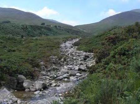


24 BEDROCK (BED) High gradient with a high transport capacity. May feature waterfalls and plunge pools as well as flat sheets of bedrock. Flow types range from turbulent to tranquil, depending on gradient channel features CASCADE STEP-POOL (CSP) Associated with steep gradients, substrate mainly boulder cobble with bedrock outcrops possible. Steps and pools create turbulent flow interspersed by more tranquil flow POOL RIFFLE GLIDE (PRG) Low to moderate gradient, sediment predominantly gravel with patches of cobbles and sand. Flow types made up of riffle sections interspersed with pools and glides LOWLAND MEANDERING (LLM) Low to no gradient lowland streams with laminar flow and fine substrates. Figure 2 Description of River Types 13


25 IC IH IH IH IH IH IH IH IH IH IH IH IH IH IC IC IC IC IC IC IC IJ IJ IJ IJ IJ IJ IJ IJ F10166F10418 F10436 F10898 F10143 F10157 F10159 F10411 F10153 F10169F10175 F10020 F10146 F10373 F10053F10066 F10375 F10060 F10083 F10364 F10056 F10358 F10366 F10464 F10469 F10211 F10462 F10551 F10203 F10552 F10194F10227 F10553 F10242 F10249 F10246 F10636 F10252 F Miles survey sites NI PRG CSP Based on the Ordnance Survey of Northern Ireland with permission of the Director and chief executive, Crown Copyright. Northern Ireland Environment Agency Copyright 2010 Figure 3 Distribution of Cascade Step Pool and Pool Riffle Glide survey sites 14
26 2.2 Biological data Macroinvertebrates were collected by NIEA-trained samplers in spring 2009 using the three minute kick sample method at a range of in-stream habitats representative of the site (Murray-Bligh et al., 1997). During sampling, the substrate was disturbed by the sampler s feet to release the macroinvertebrates, while a sampling net downstream collected dislodged individuals. A one minute active search was also undertaken by washing larger stones into the net. Macroinvertebrates were identified to family level in the NIEA UKAS accredited laboratory by pouring the sample into a series of sieves (with minimum 0.1mm mesh sieve) and distributing with water onto a number of white sampling trays. Abundance at the family level was assessed by counting the number of individuals in all trays if abundance was low. Estimates for families occurring at greater abundances were made by counting individuals in a few trays and multiplying by the total number of trays. Macroinvertebrates were grouped as shown in Table 5 to allow initial assessments of assemblages. Macrophyte surveys were carried out once for each site during the months May to September within the period 2003 to A 100m stretch of river was surveyed by NIEA-trained staff, with macrophytes identified to species level and assigned an estimated percentage cover for the 100m stretch (Holmes et al., 1999). There were more species recorded than sites surveyed so only helophytes only were used for analyses. Helophytes were grouped for analysis as shown in Table Environmental data, geology and chemistry Environmental data compiled from information collected during macroinvertebrate sampling and from NI Ordnance Survey maps and other Geographical Information System (GIS) mapping sources included altitude, slope, distance from source, width and depth of water at the site, and substrate. Dominant geology was compiled for each water course using GIS and Ordnance Survey maps, and dominant land use was identified from CORINE (Corine land cover, 2000), confirmed by aerial photos. Water chemistry samples, as required under the Freshwater Fish Directive (2006/454/EC) and compliant with WFD requirements, were collected and analysed for each site between 2006 and 2008, within the NIEA UKAS accredited laboratory system. Chemistry data, compiled from monthly measurements (2006 to 2008), 15
27 included alkalinity (ALK) (average of available data), dissolved oxygen (DO) (95 th percentile), soluble reactive phosphorus (SRP) (average), temperature (TEMP) (98 th percentile) and ammoniacal nitrogen (NH4-N) (AMMON) (90 th percentile). 2.4 Hydromorphology field assessment The hydromorphological assessment using the River Hydromorphology Assessment Technique spot check method (Parkhill and Toland, 2009) was carried out at the same locations as the invertebrate kick samples. A desktop survey was carried out before going out into the field using GIS maps and layers to identify the main characteristics of the watercourse and pressures present. The typology determined using the COMPASS tool (e.g., PRG or CSP) was verified in the field. Unlike the full RHAT survey, which is made over a stretch length of 40 times the width of the river, the RHAT spot check was undertaken from a vantage point such as a bridge or a road overlooking the invertebrate and macrophyte sampling area. The RHAT method scores deviation from natural for the assigned river type, CSP or PRG, (Fig 2) combined with visual inspection of the river features and available historical knowledge. Eight RHAT attributes assessed are provided in Table 2 with features observed and their influence on habitat. Attributes were scored on an ordinal scale from 4 for high/natural to 0 for severely modified/bad. Attributes 5 8 were scored separately for the left and right banks to the nearest 0.5. The scoring system for all attributes except A3 and A4 was: High >95-100% natural, Good >85-95% natural, Moderate >65-85% natural, Poor >25-65% natural, Bad <25% natural. Scoring for A3 was: substrate altered from natural by 0-1% for High, >l-1-5% for Good, >5-15% for Moderate, >15-30% for poor and >30% for Bad. Scoring for A4 was: High - nothing impeding flow, Good minor structures such as deflectors on wider channels, Moderate minor structures which water can flow through, Poor channel flow impeded but fish passage possible, and Bad major features with significant impact on channel continuity. The eight attribute scores were summed and divided by the total possible score (e.g., 32 unless one or more attributes were missing) to calculate the hydromorphological quality score. RHAT classes were assigned based on the resulting score as: High >0.8, Good > , Moderate > , Poor > , and Bad
28 Table 2 RHAT attributes scored and their influence on river habitat quality RHAT Attribute Features observed Influence on habitat A1. Channel morphology and flow types A2. Channel vegetation A3. Substrate diversity and condition A4. Barriers to continuity A5. Bank structure and stability A6. Bank and bank-top vegetation (Includes bank face and 1m bank top) A7. Riparian land cover (20m back from end of bank-top) A8. Floodplain interactions Planform, cross-section, bed form and obstructions. Substrate structure, width and depth variations, gradient, typology and amount of artificial features Presence, diversity and habitat potential of any vegetation, including woody debris (WD) occurring within the channel, and the amount of leaf litter and refuges, such as underwater and bank side roots for habitat. Type, quantity and diversity of substrate compared to that expected for the stream type. Quality and cleanliness of substrate, and altered substrate such as abstraction or artificial bed protection Artificial structures on the reach such as impoundments, weirs, dams. Abstraction or other flow controls affecting upstream or downstream continuity. Shape and stability of banks and degree of bank engineering. Effect that riparian or channel use has on the stability of the banks, e.g. poaching by cattle, and boat wash causing excessive bank erosion. Types, continuity and canopy layers of the bank vegetation. Degree of shading of the channel and whether the vegetation includes invasive aliens such as Himalayan balsam. Amount and type of vegetation and the intrusion of human activities close to the river. Conifer plantations, improved grass and urban land score more poorly than natural grassland or rough pasture. Natural connectivity depends on stream position and type. Channel overdeepening, overwidening, bank reinforcement, embankments and flood walls. Straightened channel will have faster flows and less habitat variation. Vegetation creates habitat and influences flow and silt movement. Benthic substrates are important habitat and impact communities if silted, dredged or artificial. Barriers cause siltation and a lack of channel lateral continuity for migration of fish and transport of organic material such as woody debris. If banks are reinforced, the marginal habitat is reduced and flow rate is increased. If banks are excessively eroded there can be extensive siltation in channel. Bank top vegetation is important for channel shading. Vegetation roots the banks reducing erosion and prevents siltation of the channel. Vegetation also provides organic input to the system such as woody debris and terrestrial insects. Intensive land use can cause pollution and increased run-off from impermeable surfaces. Interaction with the flood plain slows water in times of high flow and provides organic matter such as woody debris to the system. 17
29 2.5 Pressures database During the hydromorphology assessment, pressures along the survey stretch were recorded on the RHAT field form (Appendix IV). From this and the field notes, a pressures database was compiled of presence and absence data for alterations such as reinforcement and poaching on a localized scale. A desk top study defined pressures in the upstream reach using the GIS. The pressures were chosen because of their suspected impact on in-stream ecology (Table 3). Table 3 List of pressures recorded as present or absent in database PRESSURE ABBREVIATION Resectioned RS Reinforced RI Overwidened OW Overdeepened OD Weir Weir Poached PC Abstraction Abs Straightened Stra Culvert Culv Ford Ford Mill Mill Silt Silt Embanked Emb Road Alongside River Road Bridge With In-Channel Abutment BR Artificial Substrate arsub Dumping dump Erosion eros Slumped Bank slump Sewage Fungus SF Dominant Land Use In Catchment Rough Pasture RP Improved Grass IG Urban Urban Crop Crop Dominant Along Reach Coniferous Forest ConifF Broadleaf BL Coniferous Conif Alien Species Alien Bare Bare Woody Debris WD Fence Fenc 18
30 2.6 Statistical analyses The abundance data for macroinvertebrates and percentage cover for macrophytes had large ranges and were not normally distributed, so these data were transformed by log 10 (n+1) prior to statistical analysis. There were more macrophyte species recorded than sites surveyed, so only helophytes were used for the multi-metric analysis. Helophytes were put into functional groups assigned by their structures and traits as defined by Wilby et al., (2000) (Table 6). Macroinvertebrate families were grouped by order or major group for initial abundance assessments (Table 5). Biodiversity measures, including the Shannon diversity index, rarefied species/family richness and Pielou s evenness, were calculated for the macroinvertebrate families and macrophyte species data using the Vegan Package in R version (Venables et al., 1999). Biodiversity measures and abundances were assessed for significant differences first between CSP and PRG sites, and then between sites with RHAT classifications of good/high and less than good sites using two-sample t-tests in Minitab 14 (Minitab Inc., 2003). The relationships among sites based on their flora and fauna assemblages were assessed by Nonmetric Multi-Dimensional Scaling (NMDS) using metamds in R with Euclidean Distance (Venables et al., 1999). NMDS was chosen as it graphically represents community relationships and was recommended by McCune et al., (2002) for ecological data that are most likely non-normal. The community assemblage data were transformed by Wisconsin double standardization. Two dimensions captured most of the variance after twenty runs for macrophytes and after eight runs for the macroinvertebrates. NMDS axis 1 and 2 values for macroinvertebrate abundance and macrophyte species percentage cover were plotted with the best positions to minimize stress. The resulting axis scores were used to compare CSP and PRG sites to determine whether community assemblages differed by typology. A t-test on the scores for the first two axes of the NMDS was carried out in Minitab to assess whether axis 1 or 2 position was significantly different between CSP and PRG sites, or between RHAT classes. 19
31 To directly assess the influence of environmental pressures on river flora and fauna, an additional multivariate method was required. Legendre et al., (2001) proposed the best method for ecological research was Euclidean distance based ordination with transformed species data. Because of the linear data distribution, Redundancy Analysis (RDA) was chosen. The RDA analysis allowed investigation of the community structure of macrophytes and macroinvertebrates in relation to measured morphological and environmental variables. RDA was carried out using macroinvertebrate family abundances and macrophyte percent cover for Wilby plant groups. These two biological data sets were related to three sets of environmental data (1) the eight RHAT attributes; (2) presence/absence of hydromorphological pressures from the reach to the catchment scale; and (3) environmental factors including chemistry, slope and altitude. A permutation test for analysis of variance was carried out using anova in Vegan package in R to assess the significance of the RDA axes constraints. A total of 99 permutations were run for hydromorphological pressures and RHAT scores, 199 permutations for macroinvertebrates and environmental, and 9999 for macrophytes and environmental data. Correlation analysis was carried out, also with using with the Vegan package in R, on the environmental variables to identify correlated variables. Nine independent variables (altitude, boulder, slope, gravel, pebble, depth, alkalinity, SRP and northing grid (Y)) were retained for further analysis. Partial RDAs were carried out to enable an assessment of hydromorphology drivers after removing the influence of strong environmental drivers. This was done to enable detection of relationships with hydromorphological attributes, as these other variables may obscure hydromorphological impacts on macrophyte and macroinvertebrate assemblages (Hering et al., 2006). 20
32 RESULTS 21
33 3. RESULTS To identify the impacts of hydromorphological pressures on macrophytes and macroinvertebrates, the first goal was to identify natural differences in assemblages between cascade step pool (CSP) and pool riffle glide (PRG) river types. CSP river sections have a greater slope and generally larger substrate particles than PRG, so hydrological and morphological modifications would be expected to have different impacts on the ecology. Sites were chosen because of their High/Good water quality and 71% of the sites were assessed as having High or Good RHAT class (Table 4). Sites were chosen to be similar in terms of typology and water quality, but it was not possible to control all sources of variation and, as discussed later, differences in water chemistry, geology and land use among the sites remained. Table 4 Number of sites by type (CSP and PRG) with RHAT Hydromorphology class RHAT All Class sites CSP PRG High Good Moderat e Poor Bad The 49 sites surveyed in CSP and PRG river stretches were considered to have good water quality and assumed to support a diverse assemblage of macroinvertebrates and macrophytes with a range of habitat requirements (Table 5 and 6). There were a total of 45 macroinvertebrate families at PRG sites and 41 families at CSP sites. Macroinvertebrate families were put into 13 groups by order for Insecta or major taxonomic group for other taxa (Giller et al., 1999) (Table 5). The most common taxa found in river sites were Baetidae, Gammaridae and Heptageniidae while others such as Coenogrionidae and Asellidae were represented by only a few individuals at a few sites (Fig 4). There were a total of 21 macrophyte species at PRG and 19 species at CSP river sites. Macrophytes species were put into 15 groups to broadly assess differences in assemblages. There were broad ranges of percentage plant cover at the study sites for example Monostroma sp. was only present at one site whereas Fontanalis antipyretica was common to many sites. 22
34 Table 5 Group Mayflies Ephemeroptera Stoneflies Plecoptera Beetles Coleoptera Caddisfly Trichoptera Diptera (Chironomidae ) Trueflies (Diptera excluding chironomidae) Description of habitat and feeding requirements for macroinvertebrate families recorded at the study sites (Giller et al., 1999) Families Feeding Habitat Preferences Present Preferences Siphlonuridae Baetidae Heptageniidae Leptophlebiidae Caenidae Taeniopterygidae Nemouridae Leuctridae Capniidae Perlodidae Perlidae Chloroperlidae Haliplidae Dytiscidae Gyrinidae Hydrophilidae Scirtidae Elmidae Rhyacophilidae Hydroptilidae Philopotamidae Limnephilidae Hydropsychidae Lepidostomatidae Polycentropodida e Goeridae Beraeidae Sericostomatidae Odontoceridae Leptoceridae Chironomidae Tipulidae Simuliidae Feeding is mainly as scrapers of algae and fine detritus. Heptageniidae and Siphlonuridae are filter feeders also. Adults do not feed and only live for between a few hours and a few days. Rarely found far from water. Many families are opportunistic feeders; mainly detritivorous families include Leuctridae, Nemouridae and Taeniopterygidae; families which prey on smaller fauna like midges and blackflies include Chloroperlidae, Perlidae and Perlodidae. Dytiscidae, Gyrinidae and Hydrophilidae are predators. Elmidae feeds on fine detritus and micro-organisms Variety of feeding mechanisms. Rhyacophilidae and Polycentropodidae are predators (diet includes Chironomidae and blackfly larvae); Limnephilidae, Lepidostomatidae and Sericostomatidae are shredders; and Hydropsychidae are filter feeders Chironomidae feed on algae which they scrape from rocks and plants, some also feed on macroalgae, vascular plants and shred leaf litter. Many Tipulidae are shredders which feed on leaf litter. Simuliidae are filter feeders with some genera scraping feeders. Habitat preference includes stony substrate, burrowing in sediments and on vegetation. Sensitive to acid conditions. Baetis prefer unshaded areas Habitat preference is stony substrate interspaces or leaf packs. Tolerant of acid conditions Elmidae clings to substrate and has aquatic adults, while others such as Gyrinidae are purely aquatic. Preferred habitat includes areas of slow flow with organic matter accumulated, rocks, gravel bars and vegetation. Limnephilidae prefer shaded areas Tube building and free living Chironomidae live on rocks, plants and muddy substrates. Simuliidae and Tipulidae attach to the substrate Odonata Coenogrionidae Predators Nymphs mostly found in slow flowing water Crustacea Gammaridae Asellidae Omnivores which eat dead organic material and periphyton Habitat includes stable substrate and rooted vegetation. Gammaridae prefer low to moderate calcium bicarbonate levels Oligochaetes Oligochaetes Deposit feeders / collectors Burrow in substrate Snails Hydrobiidae Lymnaeidae Planorbidae Ancylidae Sphaeriidae Graze on periphyton and macrophytes Live in marginal vegetation and on substrate 23
Ecology and River Restoration
 Ecology and River Restoration Ecology is the study of the relationships between plants and animals and the environment in which they live. Owen, 1980 Martin Janes Managing Director The River Restoration
FINN (FERMANAGH) DATA COLLATION FOR INTERREG V
 DATA COLLATION FOR INTERREG V") FINN (FERMANAGH) DATA COLLATION FOR INTERREG V NIEA 2015 CONTENTS Page number Introduction 3 WFD Status and Objectives 3 Managing Freshwater Resources In An Integrated Catchment 4 Groundwater In Integrated
FINN (FERMANAGH) DATA COLLATION FOR INTERREG V NIEA 2015 CONTENTS Page number Introduction 3 WFD Status and Objectives 3 Managing Freshwater Resources In An Integrated Catchment 4 Groundwater In Integrated
STREAM ECOLOGY IN AN URBANIZED LANDSCAPE
 Biology 326 Spring 2010 Ecology Lab Hooper/Schwarz STREAM ECOLOGY IN AN URBANIZED LANDSCAPE Understanding human impacts on streams helps prevent detrimental effects of development and agriculture and focus
Missouri Streams. Fact Sheet. What factors affect stream habitat? Stream Habitat Affects Aquatic Communities
 Missouri Streams Fact Sheet Written by Del Lobb & Suzanne Femmer Edited by Sarah Wolken When most people think of habitat, they usually picture places where fish or wildlife live, like a hollow log or
DERG DATA COLLATION FOR INTERREG V
 DERG DATA COLLATION FOR INTERREG V NIEA 2015 CONTENTS Page number Introduction 3 WFD status and objectives 3 Managing freshwater resources in an integrated catchment 4 Narrative summary 6 Results 7 Groundwater
Review of Lake Heavily Modified Waterbody (HMWB) Designation and Classification
 Designation and Classification") River Basin Management Plans Review of Lake Heavily Modified Waterbody (HMWB) Designation and Classification December 2014 Review of Lake Heavily Modified Waterbody (HMWB) Designation and Classification
River Basin Management Plans Review of Lake Heavily Modified Waterbody (HMWB) Designation and Classification December 2014 Review of Lake Heavily Modified Waterbody (HMWB) Designation and Classification
River Nore, Kilkenny Ecological Assessment. December 2014
 River Nore, Kilkenny Ecological Assessment December 2014 Prepared by: Pascal Sweeney M.Sc., MCIEEM Sweeney Consultancy, Rahan, Mallow Co. Cork. Tel. 022/26780 TABLE OF CONTENTS 2 Page SECTION 1 INTRODUCTION
Ecological Indicators of Water Resource Pressure. Willie Duncan SEPA Jan 2013
 Ecological Indicators of Water Resource Pressure Willie Duncan SEPA Jan 2013 Outline Methods River Water Resources River Morphology Lakes Water Resources/Morphology Format Improvements over previous methods.
A Claytor Nature Center Stream Monitoring Experience
 A Claytor Nature Center Stream Monitoring Experience Conduct field investigations in which distinctions are made among observations, hypotheses, results and conclusions Perform a visual habitat assessment
SEV field sheets V10.3 October 2013 Stream Ecological Valuation (SEV) field sheets Site description. Current weather conditions(tick) Clear/sunny
 field sheets Site description. Current weather conditions(tick) Clear/sunny") SEV field sheets V10.3 October 2013 Stream Ecological Valuation (SEV) field sheets Site description Page 1 of 6 Date Stream name Site code Site location GPS coordin ates Easting Northing Current weather
SEV field sheets V10.3 October 2013 Stream Ecological Valuation (SEV) field sheets Site description Page 1 of 6 Date Stream name Site code Site location GPS coordin ates Easting Northing Current weather
2012 Mill Creek Watershed Habitat Assessment Level 3 Project Study Plan Results
 2012 Mill Creek Watershed Habitat Assessment Level 3 Project Study Plan Results Cranberry Run This project study plan was financed through a Sub-grant from the Ohio EPA with funds from the State of Ohio.
River Nore, Kilkenny Ecological Assessment. December 2015
 River Nore, Kilkenny Ecological Assessment December 2015 Prepared by: Pascal Sweeney M.Sc., MCIEEM Sweeney Consultancy, Rahan, Mallow Co. Cork. Tel. 022/26780 TABLE O CONTENTS 2 Page SECTION 1 INTRODUCTION
Assessing physical habitat condition using River MImAS
 Assessing physical habitat condition using River MImAS Why? What? How? Chris Bromley Ecology Partnership & Development Unit SEPA Overview Why did we chose the MImAS approach? What is MImAS? How does it
Background Information
 Background Information Linking Trees To Streams (Also available online at www.stroudcenter.org/lpn under the Learning Center. All images and drawings are copyright Stroud Water Research Center unless otherwise
River restoration in Europe - General principles and approaches, restoration measures, effects on river biota
 Jochem Kail University of Duisburg-Essen River restoration in Europe - General principles and approaches, restoration measures, effects on river biota General principles and approaches Holistic vs. sectoral
Biomonitoring in the Water Framework Directive
 Biomonitoring in the Water Framework Directive Presentation contents Introduction to the EU WFD Water Quality Monitoring in the WFD Why Biological Monitoring Selection of Quality Elements for Rivers Concept
Exemplar for Internal Achievement Standard. Biology Level 3
 Exemplar for Internal Achievement Standard Biology Level 3 This exemplar supports assessment against: Achievement Standard 91601 Carry out a practical investigation in a biological context, with guidance
Environmental Assessment Form Part 1 Resource Identification Enclosure C Description of Aquatic Habitat
 Environmental Assessment Form Part 1 Resource Identification Enclosure C Description of Aquatic Habitat 8. Provide a written narrative, identified and labeled as Enclosure C Description of Aquatic Habitat,
Monitoring the River Crane Water Quality and Ecology 2016
 Monitoring the River Crane Water Quality and Ecology 2016 Heathrow Airport uses specialist accredited consultants to monitor water quality and biological indicators in the River Crane, a tributary of the
A Multimetric Benthic Macroinvertebrate Index for the Assessment of Stream Biotic Integrity in Korea
 Int. J. Environ. Res. Public Health 2012, 9, 3599-3628; doi:10.3390/ijerph9103599 OPEN ACCESS Article International Journal of Environmental Research and Public Health ISSN 1660-4601 www.mdpi.com/journal/ijerph
Stream Health. Stream Bugs Our Stream Health Communicators. Upper Nottawasaga River Stream Health. NVCA Science & Stewardship
 NVCA Science & Stewardship Stream Health Upper Nottawasaga River, 2015 Stream Bugs Our Stream Health Communicators Stream bugs (benthic macroinvertebrates) are organisms that spend much or all of their
Benthic Macroinvertebrates and MS4
 Benthic Macroinvertebrates and MS4 Outline 1. Aquatic life use: Why monitor benthic macroinvertebrates? 2. Overview of benthic macroinvertebrates 3. Assessments with benthic macroinvertebrates 4. Identification
CNL(10)51. NASCO Guidelines for the Protection, Restoration and Enhancement of Atlantic salmon Habitat
51. NASCO Guidelines for the Protection, Restoration and Enhancement of Atlantic salmon Habitat") CNL(10)51 NASCO Guidelines for the Protection, Restoration and Enhancement of Atlantic salmon Habitat 1. Introduction Salmon habitat in freshwater has been greatly affected by various activities, both
CNL(10)51 NASCO Guidelines for the Protection, Restoration and Enhancement of Atlantic salmon Habitat 1. Introduction Salmon habitat in freshwater has been greatly affected by various activities, both
Clockhouse Lane Pit Lakes - Water Quality and Ecology Overview 2016
 Clockhouse Lane Pit Lakes - Water Quality and Ecology Overview 2016 Heathrow Airport uses specialist consultants to monitor the Clockhouse Lane Pit system of interconnected lakes for water quality and
Watershed Hydrology: Go with the flow. Greg Jennings, PhD, PE
 Watershed Hydrology: Go with the flow Greg Jennings, PhD, PE jenningsenv@gmail.com Streams What are your CHALLENGES? Hydrology too much water Pollutants upstream and on-site Vegetation wrong plants, wrong
Aquatic Macroinvertebrates and Stream Ecology
 Aquatic Macroinvertebrates and Stream Ecology Andy McAllister Watershed Coordinator Western PA Coalition for Abandoned Mine Reclamation 2006 AMD Conference State College, PA What are macroinvertebrates
Rapid field assessment of organic pollution with a family-level biotic index
 Rapid Field Assessment of Organic Pollution with a Family-Level Biotic Index Author(s): William L. Hilsenhoff Reviewed work(s): Source: Journal of the North American Benthological Society, Vol. 7, No.
THE WATERSHED The watershed is an area of land that drains into a stream. This includes both the surface runoff and groundwater. Because a stream is m
 Understanding Streams A stream is the product of its watershed. Good land use in the watershed will be reflected in the stream. MOST PEOPLE enjoy the captivating qualities of flowing water. But streams
Clydebank and Kirkintilloch bedrock and localised sand and gravel aquifers
 General details Water body name: Water body Identifier code: 10047 Length: Water body category: Baseline: River basin district: Area advisory group: Catchment: Associated protected areas: Associated groundwater:
Today s Webinar: Types of Monitoring and Assessment Data and What They Mean
 Welcome to the 1 st Webinar in the Series Monitoring & Assessment for Watershed Plans: Identifying, Accessing, and Using Data to Protect and Restore Indiana s Waters Each Monday in May at noon Today s
Oxon Ray Catchment Summary of significant issues affecting the water environment
 Oxon Ray Catchment Summary of significant issues affecting the water environment Introduction This information pack has been produced to support the Challenges and Choices consultation document for the
Ongoing and Completed Studies
 Attachment 2 Ongoing and Completed Studies 2014 Monitoring and Analysis Plan November 2013 Attachment 2 Ongoing and Completed Studies 1 Introduction In 2013, the small interdisciplinary study groups for
Annex. Suggestion for EC GIG
 Annex Category Introduction REFCOND-Guidance High status or reference conditions is a state in the present or in the past corresponding to very low pressure, without the effects of major industrialisation,
Basic Information: Individual Vernal Pool
 Basic Information: Individual Vernal Pool Assessment Area Name: Project Name: Assessment Area ID #: Project ID #: Assessment Team Members for This AA Date: AA Location: Latitude: Longitude: Datum: Wetland
The Importance of Riparian Forests
 The Importance of Riparian Forests By Jean Llewellyn Monroe County is the second fastest growing county in Pennsylvania. This rapid growth can be problematic because uncontrolled and unregulated growth
Understanding Florida s Stream Condition Index. Russ Frydenborg FDEP Bureau of Laboratories
 Understanding Florida s Stream Condition Index Russ Frydenborg FDEP Bureau of Laboratories Factors Affecting Aquatic Biological Communities Light penetration Temperature Habitat structure Sediment/substrate
Site Improvement Plan. River Kent SAC. Improvement Programme for England's Natura 2000 Sites (IPENS) Planning for the Future
 Planning for the Future") Improvement Programme for England's Natura 2000 Sites (IPENS) Planning for the Future Site Improvement Plan River Kent Site Improvement Plans (SIPs) have been developed for each Natura 2000 site in England
Improvement Programme for England's Natura 2000 Sites (IPENS) Planning for the Future Site Improvement Plan River Kent Site Improvement Plans (SIPs) have been developed for each Natura 2000 site in England
Mill Creek Restoration in Lower Merion Township. PH (610) ; FAX (610) ;
 ; FAX (610) ;") Mill Creek Restoration in Lower Merion Township Vincent L. Sortman 1 and Robert M. Lambert 2 1 Biohabitats, Inc., 15 W. Aylesbury Road, Timonium, MD 21093; PH (410) 337-3659; FAX (410) 583-5678; email:
Mill Creek Restoration in Lower Merion Township Vincent L. Sortman 1 and Robert M. Lambert 2 1 Biohabitats, Inc., 15 W. Aylesbury Road, Timonium, MD 21093; PH (410) 337-3659; FAX (410) 583-5678; email:
Wood-Pawcatuck Watershed Association 2002 Aquatic Benthic Macroinvertebrate Sampling Project
 Wood-Pawcatuck Watershed Association 2002 Aquatic Benthic Macroinvertebrate Sampling Project Project Collaborators: Project Leader: Wood-Pawcatuck Watershed Association Sara da Silva, University of Rhode
Water for life and livelihoods
 Water for life and livelihoods Dee River Basin District: Challenges and choices Facts and statistics Background information On 1 April Natural Resources Wales brought together the work of the Countryside
Riparian Ecology Station OBJECTIVES
 Riparian Ecology Station OBJECTIVES Students learn The basic definition of a riparian area. The condition of any riparian area greatly affects the water quality and aquatic habitat of the water body it
Freshwater Morphological Assessment in Rivers. Risk Assessment Refinement, Classification and Management. Outcome Report March 2008
 Funded by the Irish Government under the National Development Plan 2000-2006 Freshwater Morphological Assessment in Rivers Risk Assessment Refinement, Classification and Management Outcome Report March
Willow Brook Catchment Project
 Willow Brook Catchment Project Willow Brook Park Page 1 Contents 1. Introduction. 3 1.1 Background The Water Framework Directive and Drivers for Change... 3 1.2 The Willow Brook Catchment and Water Framework
IMPROVING OUTCOMES FOR STREAM ALTERATION PROJECTS
 IMPROVING OUTCOMES FOR STREAM ALTERATION PROJECTS Bethany Matousek Inland Lakes and Streams Program Coordinator Wetlands, Lakes and Streams Unit DEQ Water Resources Division MatousekB@Michigan.gov 517-243-6421
Individual NWRM. Peak flow control structures
 Individual NWRM Peak flow control structures This report was prepared by the NWRM project, led by Office International de l Eau (OIEau), in consortium with Actéon Environment (France), AMEC Foster Wheeler
Working together To improve our water environment Glazert Water
 Working together To improve our water environment Glazert Water Potential options for river restoration and natural flood management in the Glazert catchment Draft summary report 1.0 Introduction 1 Report
These potential changes and their implications are outlined in Annex 1.
 Guidance Note Hydropower Guidance Note: This Guidance Note has been prepared by Natural Resources Wales (NRW) to provide applicants for abstraction and impoundment licences for hydropower schemes with
PROJECT SCREENING MATRIX: A User s Guide
 Version 2.0 Page 1 of 7 November 9, 2010 PROJECT SCREENING MATRIX: A User s Guide BACKGROUND The Project Screening Matrix (Screening Matrix) is one of several tools that comprise the River Restoration
Appendix E: Methods of Collecting Macroinvertebrates in Streams
 Quality Assurance Project Plan DuPage-Salt Creek Assessment Revision 1.0 July 1, 2006 Appendix E Appendix E: Methods of Collecting Macroinvertebrates in Streams 1 Methods of Collecting Macroinvertebrates
COTTON CREEK CULVERT REPLACMENT
 COTTON CREEK CULVERT REPLACMENT Integrating Mobility with Environmental Innovation Located along a scenic section of Highway 3/95 in British Columbia, Moyie Bluffs, a 6.5 km stretch of inland highway had
Potential impact of cattle access on the ecological quality of rivers: some observations from Ireland
 Potential impact of cattle access on the ecological quality of rivers: some observations from Ireland M. Kelly-Quinn, E. Conroy, J. Turner, A. Rymszewicz, J.J. O Sullivan, D. Lawlor, M. Bruen, SILTFLUX
Developing a multi-metric habitat index for wadeable streams in Illinois (T-25-P-001).
.") T E C H N I C A L R E P O R T Developing a multi-metric habitat index for wadeable streams in Illinois (T-25-P-001). Annual Segment Report to the Illinois Department of Natural Resources. Laura L. Sass,
T E C H N I C A L R E P O R T Developing a multi-metric habitat index for wadeable streams in Illinois (T-25-P-001). Annual Segment Report to the Illinois Department of Natural Resources. Laura L. Sass,
Biotic Factors to Monitor Water Quality
 Biotic Factors to Monitor Water Quality Parts of a Stream or River Riffles white water area usually with rock substrate protruding through the surface of the water Runs area in between white water, without
Challenges in linking hydromorphologic to ecology. Steve Ormerod Ian Vaughan
 Challenges in linking hydromorphologic to ecology Steve Ormerod Ian Vaughan Scope: Parallels with water quality Hydromorphology: two simple needs A review of science capability Some challenges Possible
NCS Design Approach. Biology/Ecology Primer. Presented by: Jack Imhof, National Biologist Trout Unlimited Canada
 NCS Design Approach Biology/Ecology Primer Presented by: Jack Imhof, National Biologist Trout Unlimited Canada Biology/Ecology Key biological principles that are applied Need to speak the same language
2015 State Envirothon
 *Disclaimer: These tests do not reflect the information that will be on tests at the upcoming competitions.* 2015 State Envirothon Aquatics Test (75 Points Total) MULTIPLE CHOICE: Select the best possible
Chapter 5. Family-Level Macroinvertebrate Community Descriptions
 Chapter 5. Family-Level Macroinvertebrate Community Descriptions http://ceratium.ietc.wwu.edu 5-1 Family MI High Quality Headwater Stream Community Community Indicators: rolledwinged stonefly (Leuctridae),
Funded by the Irish Government under the National Development Plan Document Number: DC093
 Funded by the Irish Government under the National Development Plan 2000-2006 Shannon Internatiional Riiver Basiin Diistriict Project Freshwater Morphology POMS Study Work Package 2 Programme of Measures
Habitat and Macroinvertebrate Assessment in San Pablo Creek. Karyn Massey
 Habitat and Macroinvertebrate Assessment in San Pablo Creek Karyn Massey Abstract San Pablo Creek is an urban creek that flows through El Sobrante, San Pablo and Richmond, California. San Pablo Creek has
Soberanes Creek Status Report
 Soberanes Creek Status Report Monitoring the 2016 Soberanes Creek Fire Disturbance By Char Mane Robinson 2017 Soberanes Creek Status Report Page 1 Introduction This creek monitoring status report was prepared
Watershed Investigations: How to Assess the Health of a Stream
 Watershed Investigations: How to Assess the Health of a Stream By Joan Chadde, Western UP Center for Science, Mathematics & Environmental Education. All photos by author, unless otherwise noted. Why Monitor
Mock Stream Habitat Assessment: Bringing the outside in!
 Mock Stream Habitat Assessment: Bringing the outside in! Objectives: At the end of this activity, youth should be able to: Assess the overall health of a stream habitat Apply the terms abiotic and biotic
Chapter Four: Overview. Introduction to Environmental Geology, 5e. Case History: Endangered Trout. Ecology and Geology Linkage
 Chapter Four: Overview Introduction to Environmental Geology, 5e Chapter 4 Ecology and Geology Jennifer Barson Spokane Falls Community College Linkages between geology with ecology and relationships with
VIDEO: Riparian Forest Buffers: The Link Between Land & Water
 VIDEO: Riparian Forest Buffers: The Link Between Land & Water Introduction to Riparian Buffers Adapted from: Riparian Forest Buffers: The Link Between Land & Water. Maryland Cooperative Extension. Wye
TRCA Natural Channel Design Monitoring Program. SOSMART Group Meeting December 7, 2010
 TRCA Natural Channel Design Monitoring Program SOSMART Group Meeting December 7, 2010 Natural Channel Design (NCD) Reconstruction of a stream channel and floodplain using techniques to restore or replicate
Stable Isotope Analysis of Aquatic Macroinvertebrates, Stream Water, and Algae in Nine Mile Run, Pittsburgh, PA
 Stable Isotope Analysis of Aquatic Macroinvertebrates, Stream Water, and Algae in Nine Mile Run, Pittsburgh, PA Kassia Groszewski with Arielle Woods Troy Ferland Zachary Tieman March 25, 2015 Brief Introduction
THE BIOLOGICAL ASSESSMENT OF POLLUTION
 THE BIOLOGICAL ASSESSMENT OF POLLUTION 1. Introduction The chemical and physical environment obviously has a profound effect on plant and animal communities. Thus, the plants found on a chalk- or limestone-based
Bank and Channel Modifications. River Habitat Survey
 Bank and Channel Modifications River Habitat Survey Preparatory Work Get an idea of the site beforehand: Resources Maps Geographical Information Systems Google Earth Artificial Features (Section D) II
Water of Leith catchment profile
 catchment profile Introduction The catchment covers a total area of 122 km 2 and predominantly drains the north western slopes of the Pentland Hills from its source in the Colzium springs. The natural
Impact of an Agricultural Point Source on Macroinvertebrate Communities and Water Quality on the Lamoille River
 Impact of an Agricultural Point Source on Macroinvertebrate Communities and Water Quality on the Lamoille River Fundamentals of Ecology 12/2/05 Introduction The purpose of this study was to determine if
UK Technical Advisory Group on the Water Framework Directive. Proposed recommendations on biological standards. Consultation
 UK Technical Advisory Group on the Water Framework Directive Proposed recommendations on biological standards Consultation December 2012 Contents 1. INTRODUCTION... 4 2. OVERVIEW... 5 2.1 Rivers: Overview...
Restoration Mitigation Impacted Ambient Reference Training
 Basic Information Sheet: Perennial Estuarine Wetlands Assessment Area Name: Project Name: Assessment Area ID #: Project Site ID #: Date: Assessment Team Members for This AA Center of AA: Latitude: Wetland
Carp Creek 2013 Summary Report
 Monitoring Activity in the Carp River Watershed In 2012, Mississippi Valley Conservation Authority (MVCA) worked with Friends of the Carp River (FCR) on a preliminary assessment of the Carp River. This
Our Watershed. 5-mile Creek. Natural Features: Wetlands, small bodies of water, and Forested areas
 Team 5-Mile Creek Our Watershed 5-mile Creek Natural Features: Wetlands, small bodies of water, and Forested areas Man-made features: Farm areas, residential areas, Pond Hill Farm Special Aspects Large
Natural flood management guidance:
 Practical Guidence Natural flood management guidance: Woody dams, deflectors and diverters July 2016 Natural flood management guidance: Woody dams, deflectors and diverters July 2016 1 Introduction Large
Follow this and additional works at:
 University of Massachusetts Amherst ScholarWorks@UMass Amherst Water Resources Research Center Conferences Water Resources Research Center 4-9-2007 Evaluation of Impact of Land Use, Habitat, and Water
UK Technical Advisory Group On the Water Framework Directive. Final recommendations on new and updated biological standards
 UK Technical Advisory Group On the Water Framework Directive Final recommendations on new and updated biological standards September 2013 Contents 1. INTRODUCTION... 3 2. OVERVIEW... 4 2.1 Rivers: Overview...
Water Quality and Macroinvertebrates By Teresa Matteson and Heath Keirstead Benton Soil & Water Conservation District
 Water Quality and Macroinvertebrates By Teresa Matteson and Heath Keirstead Benton Soil & Water Conservation District Learning Objectives: Identify aquatic macroinvertebrate pictures Relate insect species/group
Pont and Blyth Investigation. Small Burn - to confluence with River Pont. Dates - 16/01/12
 Pont and Blyth Investigation Small Burn - to confluence with River Pont (Waterbody ID - GB103022077050) Dates - 16/01/12 1.0 Introduction This report is the output of a site visit undertaken by Gareth
Mangere Catchment Group Mangere River stream health investigation Field Trip
 Mangere Catchment Group Mangere River stream health investigation Field Trip Collated and narrated by Kim Jones Whitebait Connection. Photos by Susan Karels from NRC - Enviroschools We gathered around
Developing a multi-metric habitat index for wadeable streams in Illinois (T-25-P-001).
.") T E C H N I C A L R E P O R T Developing a multi-metric habitat index for wadeable streams in Illinois (T-25-P-001). Annual Segment Report to the Illinois Department of Natural Resources. Leon C. Hinz
T E C H N I C A L R E P O R T Developing a multi-metric habitat index for wadeable streams in Illinois (T-25-P-001). Annual Segment Report to the Illinois Department of Natural Resources. Leon C. Hinz
Macroinvertebrate survey and biological assessment of water quality: tributaries of Canadarago Lake; Otsego County, NY
 Macroinvertebrate survey and biological assessment of water quality: tributaries of Canadarago Lake; Otsego County, NY Marina Brown 1 INTRODUCTION New York State has used benthic invertebrates to assess
Missing Macroinvertebrates. Missing Macroinvertebrates
 Purpose: To make inferences about the quality and/or quantity of freshwater using macroinvertebrate data collected from local water systems. To explain the factors that contribute to the extinction of
7.0 WATER-BASED CONTROL MEASURES
 7.0 WATER-BASED CONTROL MEASURES 7.1 IDENTIFICATION AND DESCRIPTION OF CONTROL MEASURES Table 7-1 lists the water-based options being considered for implementation in the initial screening stage. Descriptions
Case study 6. Chelmer Valley Local Nature Reserve
 Case study 6. Chelmer Valley Local Nature Reserve Author: Trevor Bond Main driver: Habitat improvement Project stage: Completed spring 2016 Photo 1: River Chelmer, Chelmer Valley Local Nature Reserve (source:
A study of the benthic macroinvertebrate composition of the Kings River and its major tributaries to determine the water quality of the catchment.
 A study of the benthic macroinvertebrate composition of the Kings River and its major tributaries to determine the water of the catchment. Tommy Hoyne, BSc Applied Freshwater and Marine Biology. Commissioned
River Ecosystem Restoration
 River Ecosystem Restoration Habitat Assessment Methods 'In rivers, habitat is the result of predictable physical processes and so conveniently sits between the forces which structure rivers and the biota
California Rapid Assessment Method. Worksheets for the Episodic Riverine User s Manual and Field Book
 California Rapid Assessment Method Worksheets for the Episodic Riverine User s Manual and Field Book ver. 1.0 December 2015 1 Worksheet 3.1: Stream Corridor Continuity Metric for Riverine Systems Using
Created by Simpo PDF Creator Pro (unregistered version) Asst.Prof.Dr. Jaafar S. Maatooq
 Asst.Prof.Dr. Jaafar S. Maatooq") Lect.No.9 2 nd Semester Barrages, Regulators, Dams 1 of 15 In order to harness the water potential of a river optimally, it is necessary to construct two types of hydraulic structures, as shown in Figure
Lect.No.9 2 nd Semester Barrages, Regulators, Dams 1 of 15 In order to harness the water potential of a river optimally, it is necessary to construct two types of hydraulic structures, as shown in Figure
S.R. 4007, Section 14B PADEP Environmental Assessment Form. Enclosure C Description of Aquatic Habitat
 S.R. 4007, Section 14B PADEP Environmental Assessment Form Description of Aquatic Habitat Cresheim Creek is the only water resource that exists within the project area. No jurisdictional wetlands were
Likely, your students are familiar with this stream from previous presentations. We use it again to introduce these concepts:
 Teacher notes are provided. For an additional highly readable resource on benthic macroinvertebrate life cycles and habits, see A guide to Common Freshwater Invertebrates of North America, J. Reese Voshell,
FOUR BEETLES PROJECT
 FOUR BEETLES PROJECT ALEJANDRO RAMIREZ CALIFORNIA STATE UNIVERSITY, FRESNO 6/7/2016-8/5/2016 CURTIS FAIR (DISTRICT ARCHAEOLOGIST) & JOHN KELLEY (DISTRICT HYDROLOGIST) MENDOCINO NATIONAL FOREST Acknowledgements
Rascal Goose. Reach 1. Rascal Goose. Reach 2. å å å. Main Goose Pit. Stream Reach 3. Main Goose Pit. Stream Reach 7
 434000 March 16 2014 434200 434400 ± 434600 434800 435000 Goose Lake 7269800 WRSA B 7269800 7270000 433800 GIS # BAC-06-180a 7270000 PROJECT # 0234411-0005 Rascal Goose Reach 1 Main Goose Pit Stream Reach
The Streamkeepers Handbook
 The Streamkeepers Handbook A Practical Guide To Stream And Wetland Care Appendix 1 COMMON HABITAT RESTORATION TECHNIQUES Check Table 3 for the references that provide detailed instructions for these projects.
Aquatic Species Diversity and Water Quality
 Aquatic Species Diversity and Water Quality Reference: Wagner & Sanford. Environmental Science. Wiley & Sons, 2005 Introduction: Freshwater is only a small part of the Earth s supply of water, yet it is
Small Streams Risk Score Assessment of Dromore River
 Small Streams Risk Score Assessment of Dromore River Abbott Ireland Nutrition Division, Cootehill, Co. Cavan DOCUMENT DETAILS Client: Project title: F.J. Coyle and Associates Small Streams Risk Score Assessment
Maitland Valley WATERSHED
 Maitland Valley WATERSHED Report Card 2018 Maitland Conservation has prepared this report card as a summary of the state of your forests, wetlands, and water resources. WHERE ARE WE? We are one of 36 Conservation
Advisory Visit. Skitwath Beck River Eden Catchment. 9 th March 2016
 Advisory Visit Skitwath Beck River Eden Catchment 9 th March 2016 1.0 Introduction This report is the output of a site visit to Skitwath Beck and a short section of a tributary, which are themselves upper
UK Technical Advisory Group (UKTAG) on the Water Framework Directive
 on the Water Framework Directive") UK Technical Advisory Group (UKTAG) on the Water Framework Directive Environmental standards for use in classification and the Programme of Measures for the Water Framework Directive (Public Working Draft)
UK Technical Advisory Group (UKTAG) on the Water Framework Directive Environmental standards for use in classification and the Programme of Measures for the Water Framework Directive (Public Working Draft)
INTERMEDIATE BMI ASSESSMENT TIER 2 FIELD SHEET
 INTERMEDIATE BMI ASSESSMENT TIER 2 FIELD SHEET PHYSICAL PARAMETERS ASSESSMENT FIELD SHEET ALL TIERS NAME: DATE: TIME: STREAM OR RIVER NAME: WATERSHED NAME: TOWN: WEATHER PRESENT PAST 48 HOURS SITE DESCRIPTION