Section 5.8 Hydrology, Drainage, and Water Quality
|
|
|
- Muriel Harvey
- 6 years ago
- Views:
Transcription
1 Section 5.8 Hydrology, Drainage, and Water Quality
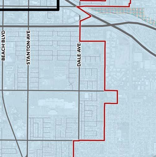
2 SECTION 5.8 HYDROLOGY, DRAINAGE, AND WATER QUALITY This section describes the existing hydrological and water quality conditions within the City of Buena Park. The potential impacts that could result from implementation of the proposed General Plan Update are analyzed, and where significant impacts are identified, mitigation measures are recommended to avoid or reduce these impacts to a less than significant level. This section includes information contained in the Hydrology Impact and Water Quality Assessment prepared by RBF Consulting (February 2010) (Appendix F) EXISTING SETTING GROUNDWATER The City relies on two major water supply sources, which include imported water from the Metropolitan Water District (MWD) and local groundwater from the Orange County Groundwater Basin, managed by the Orange County Water District (OCWD). The groundwater basin receives water via the Santa Ana River. Each year OCWD sets a basin production percentage (BPP) for the agencies that pump from the basin. The BPP is the ratio of water produced from the groundwater to all water produced by the agency. The BPP provides a limit on how much each agency can pump from the Orange County Groundwater Basin without paying a penalty. According to the City of Buena Park 2005 Water Master Plan Study Final Report (Water Master Plan) (February 2007), the City s basin pumping percentage is 66 percent and is anticipated to increase to the historical value of 75 percent. However, water supply conditions have changed over recent years and according to the City s Public Works Department, the current BPP is 62 percent and the BPP is not anticipated to rise above the current rate for a number of years. Further, it is not anticipated to reach the historical value of 75 percent in the next 10 years. 1 Groundwater wells in the City include the Ball Well, Boisseranc Well, Linden Well, Cabellero Well, Freeway Well, Holder Well, Knott Well, and Smith Murphy Well. Linden Well is the newest well constructed in Buena Park and was completed in Currently, the City s water system capacity is approximately 36,450 gallons per minute (gpm), of which 16,800 gpm are from groundwater wells; also refer to Section 5.11, Water Supply. MASTER PLAN OF DRAINAGE A Master Drainage Study was completed in 1967; however, according to the City s Public Works Department the study needs to be updated in the near future. Since the document was written, the County of Orange has thoroughly revised the methodology of calculating hydrology. A year storm is not comparable to a year storm. 2 The study presents eight separate and distinct drainage area within the City and adjacent tributary areas. Exhibit 5.8-1, Existing Drainage Facilities, identifies flood control facilities within the City. The Master Drainage Study 1 2 Written correspondence: Nabil S. Henein, Deputy City Engineer, City of Buena Park, March 22, 2010 Ibid. Draft EIR Page Buena Park General Plan Update September 2010
3 facilities, including storm drains, are planned for 10-year storm events while major channels are designed for 25-year storm events. Based on field inspections conducted by the City, the following locations are found to be inundated during high flow and in need of a storm drain system. 3 Westbound Cerritos Avenue service road west of Holder Street Eastbound Cerritos Avenue service road east of Lorinda Avenue Westbound San Diego Drive west of Holder Street Eastbound San Diego Drive east of San Marino Drive North bound Camellia Drive north of Canna Circle Northbound Western Avenue north of 91-Freeway Northbound Western Avenue north of Orangethorpe Avenue Northbound Valley View Street north of Orangethorpe Avenue Northbound Valley View Street north of Caballero Boulevard Northbound Stanton Avenue north of Orangethorpe Avenue Eastbound 4th Street east of Indiana Avenue Intersection of Orange Avenue and Holder Street Furthermore, the Master Drainage Study calls for the storm drain system at the following locations; however, to date these improvements have not been built. The necessity of these storm drain systems will need to be re-evaluated when the Master Drainage Study is updated. Indiana Avenue north of Artesia Boulevard Eighth Street east of Knott Avenue Patton Way east of Valley View Street Valley View Street south of La Palma Avenue San Rafael south of La Palma Avenue Holder Street west of Knott Avenue Knott Avenue north of La Palma Avenue El Monte Drive north of La Palma Avenue Dale Street south of 91-Freeway San Pablo Drive north of Crescent Avenue HYDROLOGIC PARAMETERS An existing conditions qualitative analysis was prepared for the project area. Hydrologic parameter calculations were evaluated based on a comparison of tributary area and proposed change in percent impervious. The types of land use and vegetation or ground cover affect the infiltration rate. Impervious values were determined using Orange County Hydrology Manual. Table 5.8-1, Existing Percent Impervious Values, provides a summary of the existing land uses and the corresponding impervious values used for the analysis. 3 Written correspondence: Nabil S. Henein, Deputy City Engineer, City of Buena Park, July 23, Page September 2010 Draft EIR Buena Park General Plan Update


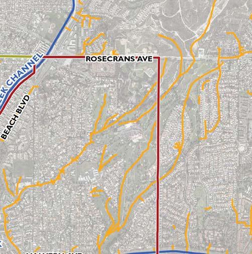


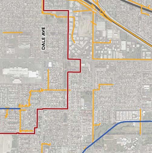

4 09/10 JN ENVIRONMENTAL IMPACT REPORT BUENA PARK GENERAL PLAN UPDATE Existing Drainage Facilities Exhibit 5.8-1
5 This page intentionally left blank. Page September 2010 Draft EIR Buena Park General Plan Update
6 General Plan Land Use Designation Table Existing Percent Impervious Values Orange County Hydrology Manual Land Use Hydrology, Drainage, and Water Quality Impervious Cover (%) Single-Family Residential 5-7 dwellings/acre 0.50 Multi-Family Residential Apartments 0.80 Commercial Retail Commercial 0.96 Commercial Hotel/Motel Commercial 0.96 Commercial Restaurant Commercial 0.90 Office Commercial 0.90 Amusement Park Commercial 0.90 Public Use Commercial 0.90 School School 0.40 Flood Control Commercial 0.90 Industrial Industrial 0.90 Light Industrial Industrial 0.85 Lake Commercial 1.00 Open Space Public Park 0.10 Railroad Commercial 0.90 Roadway Commercial 0.90 Parking Lot Commercial 0.90 Utility Commercial 0.90 Vacant Commercial 0.02 EXISTING WATERSHED DESCRIPTION The City of Buena Park storm drain system is comprised of the Orange County Flood Control District (OCFCD) regional channels and pipelines, and the City s local drainage facilities that connect to the OCFCD facilities. The City of Buena Park drainage patterns are generally towards the west or southwest and are tributary to existing flood control facilities. These facilities include Coyote Creek (A01), Brea Creek (A02), Fullerton Creek Channel (A03), Buena Park Storm Drain (A03S01), Carbon Creek Channel (B01), Bolsa Chica Channel (C02), and Moody Creek (B02). The two major flood control systems in the City of Buena Park are Coyote and Carbon Canyon Creek. Coyote Creek Channel (A01) is a major tributary of the San Gabriel River. At its confluence with the San Gabriel River, its tributary area is approximately 100,000 acres. Tributaries of Coyote Creek include its North Fold, Brea Creek Channel, Fullerton Creek Channel, Moody Creek Channel, and Carbon Creek Channel. Three existing dams, Brea, Fullerton, and Arnold detain and control mountain storm flows upstream from the City of Buena Park. Fullerton Creek Channel (A03), below Fullerton Dam, drains approximately 10,000 acres and is highly urbanized. The watershed includes parts of the cities of Fullerton, Anaheim, Buena Park, and La Palma. Buena Park Storm Channel (A03S01) confluences with Fullerton Creek within the City limits. Fullerton Creek Channel is tributary to Coyote Creek. Draft EIR Page Buena Park General Plan Update September 2010
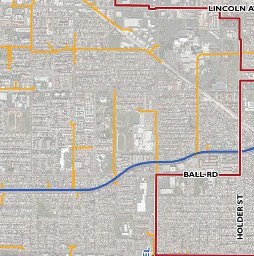
7 Carbon Creek Channel (B01) is a regional flood control facility that drains approximately 20 square miles of urbanized watershed in the northwest part of Orange County. Carbon Creek passes through the Cities of Los Alamitos, Cypress, Buena Park, Anaheim, and Fullerton. Major flows that reach Carbon Creek are delivered through the local systems which the City of Buena Park owns and maintains. Table 5.8-2, MPD Drainage Area Facilities, identifies the flood control facilities within the City s eight drainage areas. Table MPD Drainage Area Facilities Drainage Areas Flood Facilities Land Use/Impervious Value (%) Drainage Area 1 Fullerton Creek Buena Park Storm Drain Brea Creek Coyote Creek Drainage Area 2 Fullerton Creek Buena Park Storm Drain Coyote Creek Drainage Area 3 Fullerton Creek Coyote Creek Drainage Area 4 Moody Creek Drainage Area 5 Moody Creek Drainage Area 6 Carbon Creek Drainage Area 7 Bolsa Chica Carbon Creek Drainage Area 8 Coyote Creek Brea Creek Percent Impervious based on 1967 Master Drainage Study. Table 5.8-3, Existing Conditions Percent Impervious, identifies the existing General Plan area characteristics. FLOODPLAIN MAPPING The City of Buena Park is a participant in the National Flood Insurance Program (NFIP). Communities participating in the NFIP must adopt and enforce minimum floodplain management standards, including identification of flood hazards and flooding risks. Participation in the NFIP allows communities to purchase low cost insurance protection against losses from flooding. The term 100-year flood is defined by the Federal Emergency Management Agency (FEMA) as the flood elevation that has a one percent chance of being equaled or exceeded each year. A 500- year flood is one which has a 0.2 percent chance of occurring each year. A 500-year flood event would be slightly deeper and cover a greater area than a 100-year flood event. Page September 2010 Draft EIR Buena Park General Plan Update
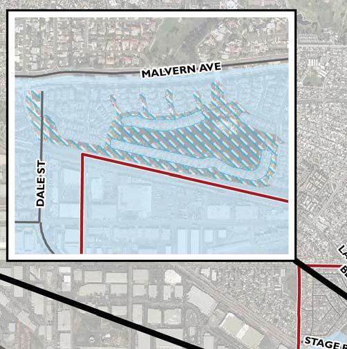
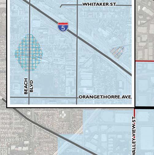
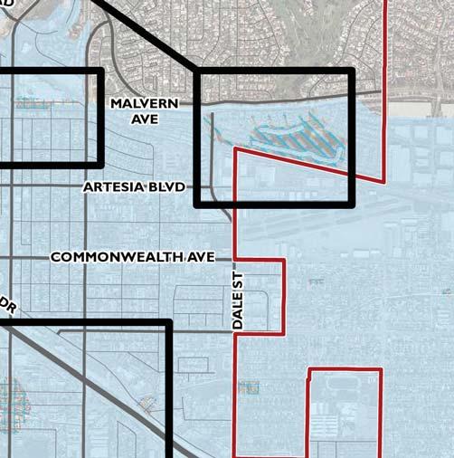
8 Table Existing Conditions Percent Impervious Focus Areas Area (acres) Impervious, C (%) Central Buena Park Civic Center Commonwealth Corridor Entertainment Corridor Entertainment Corridor North Fillmore / Jackson Area North Beach Commercial Area NW Area (JC Penney's) Orangethorpe Corridor East Orangethorpe Corridor West Other Areas Percent impervious based on area average. C = runoff coefficient. FEMA designates flood zones based on flood risk in the area. Land areas that are at high risk, within one percent annual chance of flooding are called Special Flood Hazard Areas, or floodplains. These areas are indicated on Flood Insurance Rate Maps (FIRMs). In communities that participate in the National Flood Insurance Program, mandatory flood insurance purchase requirements apply to all A Zones, which are communities subject to a 100-year flood event. The majority of the City is located outside the one percent chance (100-year) flooding; refer to Exhibit 5.8-2, FEMA Flood Zones. However, certain portions of the City lie in Zone AO, identified as having a 100-year shallow flooding with average depths between 1.0 and 3.0 feet. DAM INUNDATION According to the City s Emergency Operations Plan (November 2007), there are four dams located upstream of Buena Park, including Prado Dam, Fullerton Dam, Brea Dam, and Carbon Canyon Dam. A majority of the City is located within the dam inundation area of Prado Dam. Prado Dam is a flood control and water conservation project constructed and operated by the U.S. Army Corps of Engineers (USACE) Los Angeles District. The dam provides flood control and water conservation storage for Orange County. The dam is located approximately 22 miles northeast of the City, on the Santa Ana River, west of the City of Corona. According to USACE dam inundation maps, in the event of dam failure, the flood wave would reach Buena Park in approximately 3.25 hours and would be approximately four feet deep. A small area of the City located northeast of Auto Center Drive, west of Dale Street and just north of Whitaker Avenue is located within the dam inundation area of Fullerton Dam. Fullerton Dam may release excess waters into the Fullerton Creek Flood Control Channel and result in inundation in the surrounding area. Draft EIR Page Buena Park General Plan Update September 2010
9 The north/central portion of the City between the SR-91 Freeway and Malvern Avenue is located within the inundation areas of Brea and Carbon Canyon Dams. Excess storm flows from Brea Dam would be diverted to the Brea Creek Flood Control Channel, which merges with the Coyote Creek Channel. Carbon Canyon Dam provides flood control in and around the drainage basin. Carbon Canyon Dam is located approximately 12 miles from Buena Park. According to USACE dam inundation maps, in the event of dam failure, the flood wave would reach the City in approximately 4.25 hours and would be approximately two feet deep. STORMWATER QUALITY Storm water quality is a significant concern in southern California as storm water runoff is a significant contributor to local and regional pollution and the largest source of unregulated pollution to the waterway and coastal areas of the United States. Federal, State, regional, and local regulations require the City to control the discharge of pollutants to the storm drain system, including the discharge of pollutants from construction sites and areas of new development or significant development. The following discusses typical pollutants found in storm water runoff. Point Source Pollutants Historically, point-source pollutants have consisted of industrial operations with discrete discharges to receiving waters. Over the past several decades, many industrial operations have been identified as potential sources of pollutant discharges. For this reason, many types of industrial operations require coverage under the State of California s General Industrial Permit. This permit regulates the operation of industrial facilities and monitors and reports mechanisms to ensure compliance with water quality objectives. State regulations require industrial operations to comply with California s General Industrial Permit, which significantly lessens impacts on the quality of receiving waters. However, industrial operations that are not covered under the General Industrial Permit s jurisdiction may still have the potential to affect the water quality of receiving waters. These industrial operations would be considered non-point-source pollutants. Non-Point Source Pollutants Effects of urbanization most often result in an increase in pollutant export from the urban area. An important consideration in evaluating storm water quality within a city, is to evaluate whether it impairs the beneficial use to the receiving waters. Non-point source pollutants have been characterized by the following major parameters to assist in determining and using the pertinent data. Receiving waters can assimilate a limited quantity of various constituent elements; however, there are thresholds beyond which the measured amount becomes a pollutant and results in an undesirable impact. The following background information on these standard water quality parameters provides an understanding of typical urbanization impacts. SEDIMENT Sediment is made up of tiny soil particles that are washed or blown into surface waters. It is the major pollutant by volume in surface water. Suspended soil particles can cause the water to look cloudy or turbid. The fine sediment particles also act as a vehicle to transport other pollutants including nutrients, trace metals, and hydrocarbons. Construction sites are the largest source of sediment for urban areas under development. Another major source of sediment is stream bank erosion, which may be accelerated by increases in peak rates and volumes of runoff due to urbanization. Page September 2010 Draft EIR Buena Park General Plan Update


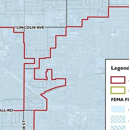
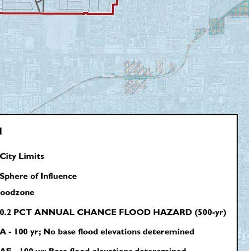


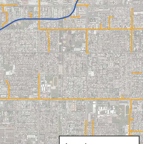
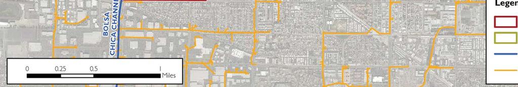
10 Source: Federal Emergency Management Agency, DFIRM Data, Effective December 3, /10 JN ENVIRONMENTAL IMPACT REPORT BUENA PARK GENERAL PLAN UPDATE FEMA Flood Zones Exhibit 5.8-2
11 This page intentionally left blank. Page September 2010 Draft EIR Buena Park General Plan Update
12 NUTRIENTS Nutrients are a major concern for surface water quality, especially phosphorous and nitrogen. The orthophosphorous form of phosphorus is readily available for plant growth. The ammonium form of nitrogen can also have severe effects on surface water quality. The ammonium is converted to nitrate and nitrite forms of nitrogen in a process called nitrification. This process consumes large amounts of oxygen, which can impair the dissolved oxygen levels in water. The nitrate form of nitrogen is very soluble and is found naturally at low levels in water. When nitrogen fertilizer is applied to lawns or other areas in excess of plant needs, nitrates can leach below the root zone, eventually reaching groundwater. Orthophosphate from auto emissions also contributes phosphorus in areas with heavy automobile traffic. As a general rule of thumb, nutrient export is greatest from development sites with the most impervious areas. Other problems resulting from excess nutrients are 1) surface algal scums; 2) water discolorations; 3) odors; 4) toxic releases; and, 5) overgrowth of plants. Common measures for nutrients are total nitrogen, organic nitrogen, total Kjeldahl nitrogen (TKN), nitrate, ammonia, total phosphate, and total organic carbon (TOC). TRACE METALS Trace metals are primarily a concern because of their toxic effects on aquatic life and their potential to contaminate drinking water supplies. The most common trace metals found in urban runoff are lead, zinc, and copper. Fallout from automobile emissions is also a major source of lead in urban areas. A large fraction of the trace metals in urban runoff are attached to sediment and this effectively reduces the level, which is immediately available for biological uptake and subsequent bioaccumulation. Metals associated with the sediment settle out rapidly and accumulate in the soils. Also, urban runoff events typically occur over a shorter duration, which reduces the amount of exposure that could pollute the aquatic environment. The toxicity of trace metals in runoff varies with the hardness of the receiving water. As total hardness of the water increases, the threshold concentration levels for adverse effects increases. OXYGEN-DEMANDING SUBSTANCES Aquatic life is dependent on the level of dissolved oxygen (DO) in water. When organic matter is consumed by microorganisms, DO is consumed in the process. A rainfall event can deposit large quantities of oxygen-demanding substances in lakes and streams. The biochemical oxygen demand of typical urban runoff is on the same order of magnitude as the effluent from an effective secondary wastewater treatment plant. A DO problem arises when the rate of oxygendemanding material exceeds the rate of replenishment. Oxygen demand is estimated by the direct measure of DO and indirect measures such as biochemical oxygen demand (BOD), chemical oxygen demand (COD), oils and greases, and total organic carbon (TOC). BACTERIA Bacteria levels in undiluted urban runoff usually exceed public health standards for recreational water contact. Studies have found that total coliform counts exceeded EPA water quality criteria at almost every site and almost every time it rained. The coliform bacteria that are detected may not be a health risk in themselves, but are often associated with human pathogens. Draft EIR Page Buena Park General Plan Update September 2010
13 OIL AND GREASE Oil and grease contain a wide variety of hydrocarbons some of which could be toxic to aquatic life in low concentrations. These materials initially float on water and create the familiar rainbow-colored film. Hydrocarbons have a strong affinity for sediment and quickly become attached to it. The major source of hydrocarbons in urban runoff is through leakage of crankcase oil and other lubricating agents from automobiles. Hydrocarbon levels are highest in the runoff from parking lots, roads, and service stations. Residential land uses generate less hydrocarbons export, although illegal disposal of waste oil into storm water can be a local problem. OTHER TOXIC CHEMICALS Priority pollutants are generally related to hazardous wastes or toxic chemicals and can be sometimes detected in storm water. Priority pollutant scans have been conducted in previous studies of urban runoff, which evaluated the presence of over 120 toxic chemicals and compounds. The scans rarely revealed toxins that exceeded the current safety criteria. The urban runoff scans were primarily conducted in suburban areas not expected to have many sources of toxic pollutants (with the possible exception of illegally disposed or applied household hazardous wastes). Measures of priority pollutants in storm water include - 1) phthalate (plasticizer compound); 2) phenols and creosols (wood preservatives); 3) pesticides and herbicides; 4) oils and greases; and 5) metals. Physical Characteristics of Surface Water Quality The amount of pollutants in surface runoff is determined by the quantity of a material in the environment and its characteristics. In an urban environment, the quantity of certain pollutants in storm water systems is generally associated with the intensity of the land use. For instance, a high volume of automobile traffic makes a number of potential pollutants (such as lead and hydrocarbons) more available. The availability of a material, such as a fertilizer, is a function of the quantity and the manner in which it is applied. Applying fertilizer in quantities that exceed plant needs leaves the excess nutrients available for loss to surface or groundwater. The physical properties and chemical constituents of water have traditionally served as the means for monitoring and evaluating water quality. Evaluating the condition of water through a water quality standard refers to its physical, chemical, or biological characteristics. Water quality parameters for storm water make up a long list and are classified in many ways. In many cases, the concentration of an urban pollutant, rather than the annual load of that pollutant, is needed to assess a water quality problem. Some of the physical, chemical, or biological characteristics that evaluate the quality of the surface runoff are outlined below: DISSOLVED OXYGEN (DO) DO in the water has a pronounced effect on the aquatic organisms and the chemical reactions that occur. It is one of the most important biological water quality characteristics in the aquatic environment. The DO concentration of a water body is determined by the solubility of oxygen, which is inversely related to water temperature, pressure, and biological activity. Dissolved oxygen is a transient property that can fluctuate rapidly in time and space. Dissolved oxygen represents the status of the water system at a particular point and time of sampling. The decomposition of organic debris in water is a slow process and the resulting changes in oxygen status respond slowly also. The oxygen demand is an indication of the pollutant load and Page September 2010 Draft EIR Buena Park General Plan Update
14 includes measurements of Biochemical Oxygen Demand (BOD) or Chemical Oxygen Demand (COD). BIOCHEMICAL OXYGEN DEMAND (BOD) The BOD is an index of the oxygen-demanding properties of the biodegradable material in the water. Samples are taken from the field and incubated in the laboratory at 20 o C, after which the residual DO is measured. The BOD value commonly referenced is the standard five-day values. These values are useful in assessing stream pollution loads and for comparison purposes. CHEMICAL OXYGEN DEMAND (COD) The COD is a measure of the pollutant loading in terms of complete chemical oxidation using strong oxidizing agents. It can be determined quickly because it does not rely on bacteriological actions as with BOD. COD does not necessarily provide a good index of oxygen demanding properties in natural waters. TOTAL DISSOLVED SOLIDS (TDS) TDS concentration is determined by evaporation of a filtered sample to obtain residue whose weight is divided by the sample volume. The TDS of natural waters varies widely. There are several reasons why TDS are an important indicator of water quality. Dissolved solids affect the ionic bonding strength related to other pollutants such as metals in the water. TDS are also a major determinant of aquatic habitat. TDS affects saturation concentration of dissolved oxygen and influence the ability of a water body to assimilate wastes. ph The ph of water is the negative log, base 10, 10, of the hydrogen ion (H+) activity. A ph of seven is neutral; a ph greater than seven indicates alkaline water; a ph less than seven represents acidic water. In natural water, carbon dioxide reactions are some of the most important in establishing ph. The ph at any one time is an indication of the balance of chemical equilibrium in water and affects the availability of certain chemicals or nutrients in water for uptake by plants. The ph of water directly affects fish and other aquatic life and generally toxic limits are ph values less than 4.8 and greater than 9.2. ALKALINITY Alkalinity is the opposite of acidity, representing the capacity of water to neutralize acid. Alkalinity is also linked to ph and is caused by the presence of carbonate, bicarbonate, and hydroxide, which are formed when carbon dioxide is dissolved. A high alkalinity is associated with a high ph and excessive solids. Most streams have alkalinities less than 200 mg/l and ranges of alkalinity of mg/l seem to support well-diversified aquatic life. SPECIFIC CONDUCTANCE The specific conductivity of water, or its ability to conduct an electric current, is related to the total dissolved ionic solids. Long-term monitoring of a project s water can develop a relationship between specific conductivity and TDS. Its measurement is quick and inexpensive and can be used to approximate TDS. Specific conductivities in excess of 2,000 micro-ohms per centimeter (µohms/cm) indicate a TDS level too high for most freshwater fish. Draft EIR Page Buena Park General Plan Update September 2010
15 TURBIDITY The clarity of water is an important indicator of water quality that relates to the ability of photosynthetic light to penetrate. Turbidity is an indicator of the property of water that causes light to become scattered or absorbed. Turbidity is caused by suspended clays and other organic particles. It can be used as an indicator of certain water quality constituents such as predicting the sediment concentrations. NITROGEN (N) Sources of nitrogen in storm water are from the additions of organic matter or chemical additions to water bodies. Ammonia and nitrate are important nutrients for the growth of algae and other plants. Excessive nitrogen can lead to eutrophication since nitrification consumes DO in the water. Organic nitrogen breaks down into ammonia, which eventually becomes oxidized to nitrate-nitrogen (N/N), a form available for plants. High concentrations of N/N in water can stimulate growth of algae and other aquatic plants, but if phosphorus (P) is present, only about 0.30 mg/l of N/N is needed for algal blooms. Some fish life can be affected when N/N exceeds 4.2 mg/l. There are a number of ways to measure the various forms of aquatic nitrogen. Typical measurements of nitrogen include Kjeldahl nitrogen (organic nitrogen plus ammonia); ammonia; nitrite plus nitrate; nitrite; and nitrogen in plants. The principal water quality criteria for nitrogen focuses on nitrate and ammonia. PHOSPHORUS (P) Phosphorus is an important component of organic matter. In many water bodies, phosphorus is the limiting nutrient that prevents additional biological activity from occurring. The origin of this constituent in urban storm water discharge is generally from fertilizers and other industrial products. Orthophosphate is soluble and is considered to be the only biologically available form of phosphorus. Since phosphorus strongly associates with solid particles and is a significant part of organic material, sediments influence concentration in water and are an important component of the phosphorus cycle in streams. The primary methods of measurement include detecting orthophosphate and total phosphorus. EXISTING STORMWATER QUALITY The City of Buena Park lacks any measured data on storm water runoff quality. In the absence of site-specific data, expected storm water quality can be qualitatively discussed by relating typical pollutants to specific land uses. Existing development within the City includes residential, commercial, office, industrial, school/civic/institutional, public facilities uses, as well as vacant land. Residential and urban development is often a significant source of storm water pollution. Development and redevelopment activities have two primary effects on water quality; they are sources of erosion and sedimentation during the construction phase and they have long-term effects on runoff once the development is complete. Residential and urban development can affect water quality in three ways: Impervious surfaces associated with development increase the rate and volume of storm water runoff, which increase downstream erosion potential; Page September 2010 Draft EIR Buena Park General Plan Update
16 Urban activities generate dry-weather ( nuisance ) flows, which may contain pollutants and/or may change the ephemeral nature of streams and the degradation of certain habitats; and Impervious surfaces increase the concentration of pollutants during wet weather flows. The potential for negative water quality effects is generally correlated to the density of development and the amount of impervious area associated with the development. Detached residential development has the potential to generate sediments such as nutrients and organic substances (including fertilizers), pesticides (from landscape application), trash and debris (including household hazardous waste), oxygen demand, oil and grease (from driveways and roads), and bacteria and viruses. Municipal Activities and Development Infrastructure and facilities (roads, streets, highways, parking facilities, storm drains and flood management facilities) present a threat to water quality. Other facilities such as parks, airfields, water treatment plants, wastewater reclamation plants, landfills and transfer centers, and corporate yards also present water quality issues. Municipalities may also own and administer areas and activities tributary to impaired water bodies and/or water quality sensitive areas that might be harmful to water quality. Commercial, Civic, and Industrial Activities and Development Certain commercial activities have the potential to generate pollutants that can negatively affect storm water quality. Auto repair shops in particular have the potential to generate heavy metals, oils, toxic chemicals, and other oxygen-demanding substances. In addition, restaurants have the potential to generate pollutants such as grease, trash, and other oxygen-demanding substances. Industrial activities can significantly affect water quality, depending on the type of pollutants and activity. In general, industrial activity is associated with effects on ambient water temperature, alkalinity levels of total suspended solids and oxygen demand. Certain industrial uses may entail the generation of heavy metals, nutrients, toxic chemicals, and other pollutants. Industrial uses that take place indoors do not have storm water pollutant exposure and present little threat to storm water quality. The City of Buena Park s primary receiving waters are Coyote and Carbon Creeks. These creeks are tributary to San Gabriel River Reach 1. This reach has been listed on the 2006 Clean Water Act Section 303(d) list with the main pollutant being Coliform Bacteria and ph. Portion of Coyote Creek within the Los Angles Regional Water Quality Control Board (RWQCB) is also listed on the 303(d) list with the main pollutant being Ammonia REGULATORY FRAMEWORK Applicable Federal, State, and local regulatory policies and law that apply to hydrology, drainage, and water quality are discussed below. Surface water quality is subject to Federal, State, and local water quality requirements administered and enforced by the U.S. Environmental Protection Agency (U.S. EPA), the State Water Resources Control Board (SWRCB), and the Regional Water Quality Control Boards (RWQCBs) with cooperation from each county. Draft EIR Page Buena Park General Plan Update September 2010
17 CLEAN WATER ACT The principal law governing pollution of the nation s surface waters is the Clean Water Act (CWA), formerly known as the Federal Water Pollution Control Act (FWPCA). Originally enacted in 1948, it has been amended several times since. As amended in 1977, the law became commonly known as the CWA. The CWA is a Federal law that protects the nation s surface waters, including lakes, rivers, coastal wetlands, and waters of the United States. The CWA includes provisions that authorize Federal financial assistance for municipal sewage treatment plants and the regulatory requirements that apply to industrial and municipal dischargers. The law authorized states to set effluent standards on an industry basis. In addition, the CWA requires states to adopt water quality standards that consist of the designated uses of the navigable waters involved and the water quality criteria for such waters based upon such uses. The CWA specifies that discharges to waters are illegal, unless authorized by an appropriate permit. The permits regulate the discharge of dredged and fill materials, construction-related storm water discharges, and activities that may result in discharges of pollutants to waters of the U.S.. Section 404 of the CWA establishes a permit program for the discharge of dredge or fill materials into waters of the U.S. This permit program is administered by the U.S. Army Corps of Engineers (USACE). If waters of the U.S. are located on or downstream of a project site, the project may discharge to them, and if impacts on them are anticipated, the project must obtain a CWA Section 401 Water Quality Certification from the appropriate RWQCB. Section 402 of the CWA establishes the National Pollutant Discharge Elimination System (NPDES), a permitting system for the discharge of any pollutant (except for dredge or fill material) into waters of the U.S. This permitting program is administered by the RWQCBs. In addition, Section 303 and 304 of the CWA provide for water quality standards, criteria, and guidelines. NATIONAL POLLUTANT DISCHARGE ELIMINATION SYSTEM As discussed above, the NPDES is the permitting program for discharge of pollutants into waters of the U.S. under Section 402 of the CWA. Thus, dischargers must obtain permits from the appropriate RWQCB. The NPDES program is administered by the U.S. EPA, which delegates oversight in California to the RWQCBs. The NPDES program provides general permits and individual permits. The general permits include requirements for construction projects that disturb more than one acre of land. The general permit requires the applicant to file a public notice of intent to discharge storm water and to prepare and implement a Storm Water Pollution Prevention Plan (SWPPP). A SWPPP includes a site map, description of proposed activities, demonstration of compliance with applicable ordinances and regulations, and a description of Best Management Practices (BMPs) that would be implemented to reduce erosion and discharge of construction-related pollutants. Point source dischargers of pollutants into surface waters are required to obtain an NPDES permit. The Municipal Storm Water Permitting Program regulates storm water discharges from municipal separate storm sewer systems (MS4s). MS4 permits are issued through two phases. The NPDES Phase I storm water program requires municipalities serving greater than 100,000 persons to obtain a NPDES storm water permit for construction projects greater than five acres in size. NPDES Phase II storm water regulations expanded this existing national program to smaller municipalities with populations of 10,000 persons or more and construction sites that disturb one to five acres. Other dischargers, such as those affecting groundwater or from nonpoint sources are required to file a Report of Waste Discharge with the appropriate RWQCB. For Page September 2010 Draft EIR Buena Park General Plan Update
18 specified situations, some permits may be waived and some discharge activities may be handled through enrollment in an existing general permit. Impaired Waterbodies The CWA Section 303(d) and the California s Porter-Cologne Water Quality Control Act (described below) require the State to establish the beneficial uses of its State waters and to adopt water quality standards to protect those beneficial uses. Section 303(d) establishes a Total Maximum Daily Load (TMDL) program, which sets the maximum quantity of a particular contaminant that a water body can maintain without experiencing adverse effects, to guide the application of State and regional water quality standards. Section 303(d) also requires the State to identify impaired streams (water bodies affected by the presence of pollutants or contaminants) and to establish the TMDL of each pollutant for each identified stream. PORTER-COLOGNE WATER QUALITY CONTROL ACT The Porter-Cologne Water Quality Control Act acts in cooperation with the CWA to establish the SWRCB. The SWRCB and nine RWQCB, overseen by the SWRCB, are responsible for protecting California s surface waters and groundwater supplies. The Porter-Cologne Water Quality Control Act establishes Basin Plans for each of the nine regions overseen by the RWQCB. The City of Buena Park is located within the jurisdiction of the Santa Ana RWQCB (Region 8). The Basin Plans also establish narrative and numerical water quality objectives for those waters. Basin Plans are updated every three years and provide the basis of determining waste discharge requirements, taking enforcement actions, and evaluating clean water grant proposals. The Porter-Cologne Water Quality Control Act is also responsible for implementing CWA Sections and 303(d) to SWRCB and RWQCBs. STATE WATER QUALITY CONTROL BOARD AND REGIONAL WATER QUALITY CONTROL BOARD The SWQRCB administers water rights, water pollution control, and water quality functions throughout the State, while the RWQCBs conduct planning, permitting and enforcement activities. While the U.S. EPA allows two permitting options to meet NPDES requirements (individual permits and general permits), the SWRCB has elected to adopt one statewide General Permit for Discharges of Storm Water Associated with Construction Activity (Construction General Permit, DWQ) for California that applies to all construction-related storm water discharges, except for those on tribal lands in the Lake Tahoe Hydrologic Unit and those performed by the Department of Transportation (Caltrans). The new Construction General Permit will be in effect July 1, The City of Buena Park is located within the jurisdiction of the Santa Ana RWQCB (Region 8). Dischargers whose projects disturb one or more acres of soil or whose projects disturb less than one acre but are part of a larger common plan of development that in total disturbs one or more acres, are required to obtain coverage under the General Permit for Discharges of Storm Water Associated with Construction Activity (Construction General Permit, DWQ). Construction activity subject to this permit includes clearing, grading, and disturbances to the Draft EIR Page Buena Park General Plan Update September 2010
19 ground such as stockpiling, or excavation. The General Permit requires all dischargers whose construction activity disturbs one-acre or more to: Prepare Storm Water Pollution Prevention Plans (SWPPP) before construction begins; File a Notice of Intent (NOI) with the State Board before construction begins; and File a Notice of Termination with the State Board once construction is complete. Storm Water Pollution Prevention Plan. The SWPPP is directed toward construction staff and describes the erosion and runoff control measures to be used during and after construction, and provides a plan to inspect and maintain these control measures. The SWPPP may be revised during construction in response to changed conditions, or if the properly installed BMPs are ineffective in preventing sediment transport off the site. Revisions to the SWPPP are also required if there are changes in activities which could result in a significant amount of pollutants discharged in storm water. Notice of Intent. The NOI certifies that the applicant will comply with conditions in the statewide general NPDES permit. It is not a permit application and does not require approval, although an annual fee must be submitted with the NOI. Notice of Termination. The State Board must be notified (via a Notice of Termination form) once construction is complete. It must also be notified if a change of ownership occurs during construction. In this case, a revised NOI must be submitted, and the SWPPP must be revised by the new owner to reflect any changes in construction conditions. The general construction permit requires that the project owner arrange for maintenance of drainage/storm water control facilities after project completion; maintenance may be done by private parties or by a public agency such as a community service district. Municipalities may require maintenance agreements. Construction project proponents may request to be placed under individual NPDES permits rather than the general permit. The Regional Board may issue individual storm water NPDES permits to construction projects when more stringent controls are necessary to protect water quality. Individual construction projects may also be regulated under a municipality's NPDES management program. The Municipal Storm Water Permitting Program regulates storm water discharges from municipal separate storm sewer systems (MS4s). MS4 permits were issued in two phases: Under Phase I, for medium (serving between 100,000 and 250,000 people) and large (serving 250,000 people) municipalities, and Phase II, for smaller municipalities. Under Phase I, the RWQCB have adopted NPDES storm water permits for medium and large municipalities, most of which are issued to a group of co-permittees encompassing an entire metropolitan area. The MS4 permits require the discharger to develop and implement a Storm Water Management Plan/Program with the goal of reducing the discharge of pollutants to the maximum extent practicable (MEP). MEP is the performance standard specified in Section 402(p) of the Clean Water Act. The management programs specify what BMPs would be used to address certain program areas. The Santa Ana RWQCB is currently operating under MS4 permit, Order No. R , NPDES Permit No. CAS618030, adopted in May This permit requires the creation of a Drainage Area Management Plan (DAMP) that reduces the pollution content of stormwater to the Maximum Extent Practicable (MEP). The purpose of the Orange County Drainage Area Management Plan (DAMP) is to satisfy NPDES permit conditions for creating and implementing Page September 2010 Draft EIR Buena Park General Plan Update
20 a Storm Water Management Plan/Program to reduce pollutant discharges to the MEP. The DAMP contains guidelines on structural and nonstructural BMPs for meeting the NPDES goals. The DAMP identifies activities required to implement the minimum control measures required under the Municipal Permit. In order to ensure that construction sites implement the appropriate pollution control measures, the 2003 DAMP details recommended BMPs to be applied to new development and significant redevelopment in Orange County. Projects are identified as either priority projects or non-priority projects. The City of Buena Park, as a Co-Permittee, participates in the implementation of the DAMP, by requiring a WQMP. Buena Park has adopted a WQMP, dated May 2005, which consists of variety of measures. The City s current WQMP is based on the previous Order No. R and therefore will be required to comply with the new permit (Order No. R ). The City currently requires: A National Pollution Discharge Elimination System (NPDES) General Construction Permit must be obtained from the Santa Ana RWQCB for construction projects involving a ground disturbance of at least 1.0 acre. Applicants shall prepare and submit a Notice of Intent (NOI) to comply with the Construction General Permit to the California State Water Resources Board. All dischargers must prepare, retain at the construction site, and implement a Storm Water Pollution Prevention Plan (SWPPP) prior to issuance of a grading permit. A WQMP must be approved prior to any issuance of building permits. The WQMP specifies the Best Management Practices (BMPs) to be incorporated into the project design, in accordance with the County DAMP or local city WQMP guidance. The City may require development of a WQMP for any projects other than the requirement listed above. BUENA PARK MUNICIPAL CODE Title 18 Subdivisions and Floodplain Management Buena Park Municipal Code (Municipal Code) Title 18, Subdivisions and Floodplain Management, identifies regulations to promote the public health, safety and general welfare, and to minimize public and private losses due to flood conditions in specific areas of the City of Buena Park. Specifically, Chapter , Review of Development within Flood Hazard Area, requires any development within a special flood hazards zone to be reviewed and approved by the City Engineer, or designee. Chapter , Construction, elevation and anchoring standards, mandates specific siting, design, and construction requirements for development within a flood zone. Chapter Stormwater Drainage Municipal Code Section , Control of urban runoff, requires all new development and significant redevelopment within the City comply with the DAMP and any conditions and Draft EIR Page Buena Park General Plan Update September 2010
21 requirements established by the City, which are reasonably related to the reduction or elimination of pollutants in stormwater runoff from the project site. Section , Permit Requirements for Industrial/Commercial and Construction Activities, specifies that each discharger associated with construction activity shall comply with all requirements of such permit. Each discharger identified in an individual NPDES permit issued by the U.S. Environmental Protection Agency, the State Water Resources Control Board, or any regional water quality control board shall comply with and undertake all activities required by such permit. Proof of compliance with any such permit may be required in a form acceptable to the director, or his/her designated representative, prior to the issuance of any Grading, Building or Occupancy Permits, or any other type of permit or license issued by the City. BUENA PARK WATER QUALITY MANAGEMENT PLAN The City of Buena Park Water Quality Management Plan for New Development and Significant Redevelopments (WQMP) outlines steps to reduce stormwater pollution at project sites. 4 The WQMP addresses the relevant pollution issues at the site, how they will be addressed in the site design, and how the Best Management Practices (BMPs) implemented at the site will be maintained in perpetuity. Although, the WQMP briefly addresses stormwater issues associated with construction, its main purpose is to assure that the right structural and non-structural BMPs have been designed into the project plans and to assign long-term responsibility for those BMPs SIGNIFICANCE THRESHOLD CRITERIA Appendix G of the CEQA Guidelines contains the Initial Study Environmental Checklist, which was included with the Notice of Preparation to show the areas being analyzed within the EIR; refer to Appendix A of this EIR. The Initial Study includes questions relating to hydrology, drainage, and water quality. The issues presented in the Initial Study Checklist have been utilized as thresholds of significance in this Section. Accordingly, hydrology, drainage, and water quality impacts resulting from the implementation of the proposed General Plan Update may be considered significant if they would result in the following: Violate any water quality standards or waste discharge requirements; Substantially deplete groundwater supplies or interfere substantially with groundwater recharge such that there would be a net deficit in aquifer volume or a lowering of the local groundwater table level (e.g. the production rate of pre-existing nearby wells would drop to a level which would not support existing land uses or planned uses for which permits have been granted); Substantially alter the existing drainage pattern on the site or area, including through the alteration of the course of a stream or river, in a manner which would result in substantial erosion or siltation on-or off-site; Substantially alter the existing drainage pattern of the site or area, including through the alteration of the course of a stream or river, or substantially increase the rate or amount of surface runoff in a manner which would result in flooding on- or off-site; 4 City of Buena Park Water Quality Management Plan for New Development and Significant Redevelopments, prepared by the City of Buena Park Public Works Department Stormwater Division, May Page September 2010 Draft EIR Buena Park General Plan Update
22 Create or contribute runoff water which would exceed the capacity of existing or planned storm water drainage systems or provide substantial additional sources of polluted runoff; Otherwise substantially degrade water quality; Place housing within a 100-year flood hazard area as mapped on a federal Flood Hazard Boundary or Flood Insurance Rate Map or other flood hazard delineation map; Place within a 100-year flood hazard area structures which would impede or redirect flood flows; Expose people or structures to a significant risk of loss, injury or death involving flooding, including flooding as a result of the failure of a levee or dam; and/or Inundation by seiche, tsunami, or mudflow (refer to Section 8.0, Effects Found Not To Be Significant). Based on these standards, the effects of the proposed project have been characterized as either a less than significant impact or a potentially significant impact. Mitigation measures are recommended for potentially significant impacts. If a potentially significant impact cannot be reduced to a less than significant impact level through the application of mitigation, it is categorized as a significant unavoidable impact IMPACTS AND MITIGATION MEASURES SHORT-TERM CONSTRUCTION WATER QUALITY IMPACTS GRADING, EXCAVATION, AND CONSTRUCTION ACTIVITIES ASSOCIATED WITH THE PROPOSED GENERAL PLAN UPDATE COULD SIGNIFICANTLY IMPACT WATER QUALITY DUE TO EROSION AND TRANSPORT OF EXPOSED SOILS. Impact Analysis: Construction controls are separated from other water quality management, because the measures are temporary and specific to the type of construction. Construction of future development projects has the potential to produce typical pollutants such as nutrients, heavy metals, pesticides and herbicides, toxic chemicals related to construction and cleaning, waste materials including wash water, paints, wood, paper, concrete, food containers and sanitary wastes, fuel, and lubricants. Generally, standard safety precautions for handling and storing construction materials can adequately reduce the potential pollution of stormwater by these materials. These types of standard procedures can be extended to non-hazardous stormwater pollutants such as sawdust, concrete washout, and other wastes. In addition, grading activities can greatly increase erosion processes, leading to impacts on storm drains and sediment loading to storm runoff flows. Two general strategies are recommended to prevent soil materials from entering local storm drains. First, erosion control procedures should be implemented for those areas that must be exposed, and secondly, any development site should be secured to control off-site transport of pollutants. Draft EIR Page Buena Park General Plan Update September 2010
IV. ENVIRONMENTAL IMPACT ANALYSIS G. HYDROLOGY/WATER QUALITY
 IV. ENVIRONMENTAL IMPACT ANALYSIS G. HYDROLOGY/WATER QUALITY ENVIRONMENTAL SETTING The project site is located in the Wilshire community of the City of Los Angeles and is bound by S. Wetherly Drive to
4.8 - Hydrology and Water Quality
 County of Riverside Public Safety Enterprise Communication Project Hydrology and Water Quality 4.8 - Hydrology and Water Quality 4.8.1 - Introduction This section describes the existing setting regarding
APPENDIX N Guidance for Preparing/Reviewing CEQA Initial Studies and Environmental Impact Reports
 APPENDIX N N.1 Guidance for Preparing and Reviewing CEQA Initial Studies Step 1: Consider the Project Characteristics as Provided by the Project Applicant Review the project application and draft plan
3F. Hydrology and Water Quality
 This section provides an analysis of potential hydrological and water quality impacts associated with implementation of the proposed project. The section also evaluates and describes the potential impacts
APPENDIX H Guidance for Preparing/Reviewing CEQA Initial Studies and Environmental Impact Reports
 APPENDIX H H.1 Guidance for Preparing and Reviewing CEQA Initial Studies Step 1: Consider the Project Characteristics as Provided by the Project Applicant Review the project application and draft plan
5.2 HYDROLOGY AND WATER QUALITY
 5.2 HYDROLOGY AND WATER QUALITY This section of the EIR evaluates the impacts of the proposed project on hydrology/drainage and water quality. The discussion of hydrology and water quality impacts presented
5.10 HYDROLOGY AND WATER QUALITY
 5.10 HYDROLOGY AND WATER QUALITY This section analyzes potential project impacts on existing drainage patterns, surface hydrology and flood control facilities and water quality conditions in the project
3.6 HYDROLOGY AND WATER QUALITY Environmental Setting
 3.6 HYDROLOGY AND WATER QUALITY This section of the Environmental Impact Report (EIR) describes existing hydrology and water quality resources, and analyzes potential impacts resulting from implementation
Stormwater Management in Your Backyard: Stormwater 101
 Stormwater Management in Your Backyard: Stormwater 101 Gregory Rusciano Program Associate, Water Resources Rutgers Cooperative Extension New Jersey Sea Grant Extension Program How much water do we have?
5.8 HYDROLOGY AND WATER QUALITY
 5.8 HYDROLOGY AND WATER QUALITY This section of the environmental impact report (EIR) identifies and analyzes regional and local surface water and groundwater resources that could affect or be affected
3G. Hydrology and Water Quality
 INTRODUCTION This chapter assesses the potential impacts to surface water hydrology, surface water quality, groundwater hydrology, and groundwater quality resulting from the development of the proposed
5. Environmental Analysis
 5.5 HYDROLOGY AND WATER QUALITY This section evaluates the potential impacts to hydrology and water quality conditions associated with the Proposed Project. Hydrology deals with the distribution and circulation
ORDINANCE # 854. Stormwater Management / Operation and Maintenance Requirements
 ORDINANCE # 854 Stormwater Management / Operation and Maintenance Requirements Section 1. Purpose and Authority In accordance with the provisions of Chapters 98, 124, 126, 440, 444, and 446h of the General
This section addresses the water resources, hydrology and water quality that would change due to the proposed project.
 4.12 WATER RESOURCES This section addresses the water resources, hydrology and water quality that would change due to the proposed project. 4.12.1 EXISTING SETTING The project site is located in the Los
4.6 - Hydrology and Water Quality
 City of Wasco - Wasco Center Walmart Hydrology and Water Quality 4.6 - Hydrology and Water Quality 4.6.1 - Introduction This section provides an evaluation of hydrology and water quality. The analysis
Section 5.10 HYDROLOGY AND WATER QUALITY
 Section 5.10 HYDROLOGY AND WATER QUALITY 5.10 HYDROLOGY AND WATER QUALITY This section of the EIR evaluates the impacts of the proposed project on site drainage, stormwater hydrology, and surface water
Wastewater ENVIRONMENTAL SETTING. Wastewater Collection
 4.15.3.1 ENVIRONMENTAL SETTING Wastewater Collection The City owns, operates, and maintains the local sewer lines that collect wastewater generated within the City. The existing sewer lines include a gravity
Home Remodeling Projects
 Should your project require a Standard Urban Stormwater Mitigation Plan (SUSMP), please see the City of Pomona s Standard Urban Stormwater Mitigation Plan (SUSMP) Pamphlet Best Management Practices For
TOWN OF BERKLEY ARTICLE 32 STORM WATER BYLAW
 TOWN OF BERKLEY ARTICLE 32 STORM WATER BYLAW Land development projects and other land use conversions, and their associated changes to land cover, permanently alter the hydrologic response of local watersheds
Stormwater Programs. BIA Meeting June 5, Jason Uhley
 Stormwater Programs BIA Meeting June 5, 2014 Jason Uhley Chief of Watershed Protection Riverside County Flood Control and Water Conservation District Presentation Outline Clean Water Act Stormwater Program
IV.E. HYDROLOGY AND WATER QUALITY
 IV.E. HYDROLOGY AND WATER QUALITY The following section presents the information provided in the hydrology report prepared by Sukow Engineering. Supporting hydrology data from this report is included in
3.10 Hydrology and Water Quality. Environmental Setting
 3.10 Hydrology and Water Quality This section describes the potential hydrology and water quality impacts associated with the proposed changes to the approved project. Environmental Setting This section
City of San Juan Capistrano. Agenda Report. Honorable Mayor and Members of the City Council. Steve May, Public Works and Utilities Director 4-tUA.
 3/21/2017 E12 City of San Juan Capistrano Agenda Report TO: FROM: SUBMITTED BY: Honorable Mayor and Members of the City Council ~Siegel, City Manager Steve May, Public Works and Utilities Director 4-tUA.--
STATE OF FLORIDA DEPARTMENT OF ENVIRONMENTAL PROTECTION GENERIC PERMIT FOR DISCHARGE OF STORMWATER FROM PHASE II
 STATE OF FLORIDA DEPARTMENT OF ENVIRONMENTAL PROTECTION GENERIC PERMIT FOR DISCHARGE OF STORMWATER FROM PHASE II MUNICIPAL SEPARATE STORM SEWER SYSTEMS May 1, 2003 1 Generic Permit for Discharge of Stormwater
RIVERSIDE COUNTY DRAINAGE AREA MANAGEMENT PLAN SANTA ANA AND SANTA MARGARITA REGIONS
 RIVERSIDE COUNTY DRAINAGE AREA MANAGEMENT PLAN SANTA ANA AND SANTA MARGARITA REGIONS JULY 2005 6.0 D EVELOPMENT PLANNING 6.1 INTRODUCTION With the adoption of the Third-term MS4 Permits, the Permittees
Water Quality Regulatory Programs and Our Citywide EPA / DEQ Stormwater Permit. Public Works Engineering City Council Briefing June 7, 2016
 Water Quality Regulatory s and Our Citywide EPA / DEQ Stormwater Permit Public Works Engineering City Council Briefing June 7, 2016 Briefing Topics Introduction: Regulatory Overview Elements of the MS4
This section evaluates potential hydrology and water quality impacts associated with the project.
 Section 3.7 Hydrology and Water Quality This section evaluates potential hydrology and water quality impacts associated with the project. 3.7.1 Regulatory Framework Federal The U.S. EPA regulates water
APPENDIX A EXCERPTS FROM THE PERMIT
 APPENDIX A EXCERPTS FROM THE PERMIT NPDES CAS004001-45 - Order No. 01-182 F. PUBLIC AGENCY ACTIVITIES PROGRAM Each Permittee shall implement a Public Agency program to minimize storm water pollution impacts
G. HYDROLOGY Existing Conditions
 G. HYDROLOGY Existing Conditions Surface Water Runoff This section is based on the hydrology and drainage analysis for the proposed Project, which was prepared by KPFF Consulting Engineers and is attached
Post-Development Stormwater Runoff Performance Standards
 Post-Development Stormwater Runoff Performance Standards December 9, 2014 Topics Why performance standards? What practices/requirements are in effect in other States? The Workgroup s preliminary and final
Non-Priority Projects WQMP Preparation Guidance Manual
 Non-Priority Projects WQMP Preparation Guidance Manual December 2005 Table of Contents 1.0 Introduction... 1 2.0 Requirements for Development Projects...1 3.0 WQMP Preparation... 2 3.1 Cover Page... 2
Municipal Stormwater Management Plan Prepared For The Borough of Cape May Point By Van Note-Harvey Associates VNH File No.
 Municipal Stormwater Management Plan Prepared For The Borough of Cape May Point By Van Note-Harvey Associates 2005 VNH File No. 35317-210-21 Table of Contents Introduction... 3 Goals... 3 Storm water Discussion...
WATER QUALITY MANAGEMENT PLAN PROCEDURES
 PUBLIC WORKS DEPARTMENT DEVELOPMENT SERVICES DIVISION SUBDIVISION SERVICES SECTION City Hall East 200 S. Anaheim Boulevard. 2 nd Floor Anaheim, California 92805 www.anaheim.net/publicworks WATER QUALITY
4.10 HYDROLOGY AND WATER QUALITY
 County of Nevada Housing Element Rezone Implementation Program 4.10 HYDROLOGY AND WATER QUALITY This section evaluates potential hydrology and water quality impacts that could result from the Nevada County
IV. ENVIRONMENTAL IMPACT ANALYSIS D. DRAINAGE AND SURFACE WATER QUALITY
 IV. ENVIRONMENTAL IMPACT ANALYSIS D. DRAINAGE AND SURFACE WATER QUALITY The analysis of drainage impacts included in this section is based on the Storm Drainage Environmental Impact Report prepared by
Streamlines V2, n2 (May 1997) A Newsletter for North Carolina Water Supply Watershed Administrators
 A Newsletter for North Carolina Water Supply Watershed Administrators") Page 1 of 5 STREAMLINES A Newsletter for North Carolina Water Supply Watershed Administrators Volume 2, Number 2 May 1997 Non-Point Source (NPS) Pollution This issue of Streamlines provides basic information
Page 1 of 5 STREAMLINES A Newsletter for North Carolina Water Supply Watershed Administrators Volume 2, Number 2 May 1997 Non-Point Source (NPS) Pollution This issue of Streamlines provides basic information
CCSD#1 Stormwater Standards
 SECTION 6 EROSION CONTROL STANDARDS 6.1 INTRODUCTION The policies of this section shall apply during construction and until permanent measures are in place following construction as described herein, unless
City of Fairmont Storm Water Pollution Prevention Plan (SWPPP) January 23, 2017
 January 23, 2017") City of Fairmont Storm Water Pollution Prevention Plan (SWPPP) January 23, 2017 Why is Water Quality Important? Water has always been important to Minnesota and is a key part of our history, culture, economy
City of Fairmont Storm Water Pollution Prevention Plan (SWPPP) January 23, 2017 Why is Water Quality Important? Water has always been important to Minnesota and is a key part of our history, culture, economy
APPENDIX M CEQA Initial Study Checklist
 APPENDIX M CEQA Initial Study Checklist Appendix G ENVIRONMENTAL CHECKLIST FORM (To be Completed by Applicant) 1. Project title: 2. Lead agency name and address: 3. Contact person and phone number: 4.
4.8 HYDROLOGY AND WATER QUALITY
 4.8 HYDROLOGY AND WATER QUALITY 4.8.1 INTRODUCTION The Hydrology and Water Quality chapter of the Draft EIR describes existing drainage and water quality setting for the project site, and evaluates potential
4.7 HYDROLOGY AND WATER QUALITY
 4.7 HYDROLOGY AND WATER QUALITY INTRODUCTION The proposed stormwater drainage system for the proposed Via Princessa project would consist of curb and gutters, catch basins, and storm drain culverts crossing
Contractors, Illicit Discharges, & Best Management Practices. Chris Allen Stormwater Inspector
 Contractors, Illicit Discharges, & Best Management Practices Chris Allen Stormwater Inspector What is an Illicit Discharge? Georgetown County Stormwater Ordinance defines an Illicit Discharge as: Any activity
4.3 WATER RESOURCES ALTERNATIVE A PREFERRED CASINO-RESORT PROJECT SURFACE WATER
 4.3 WATER RESOURCES 4.3.1 ALTERNATIVE A PREFERRED CASINO-RESORT PROJECT SURFACE WATER This section discusses potential direct and indirect impacts associated with the development of Alternative A on surface
Responses to Comments from State Agencies
 Summary of Comment Letters Received from State Agencies This section provides responses to comments received on the draft environmental document from state agencies. Comment Code Agency S-1 California
5.4 HYDROLOGY AND WATER QUALITY
 5.4 HYDROLOGY AND WATER QUALITY SUMMARY The proposed stormwater drainage system for the proposed Lyons Avenue at-grade rail crossing would consist of a 30-inch stormwater drain, which would replace the
S.O.P. No. HMD
 Page: 1 of 9 PURPOSE: To establish (SOP) for submission requirements, review process and approval of applications for Non-vehicular Access Permits for the purpose of connection or discharge to any MassDOT
Hydrology and Water Quality. Water. Water 9/13/2016. Molecular Water a great solvent. Molecular Water
 Hydrology and Water Quality Water Molecular Water Exists as an equilibrium But equilibrium altered by what is dissolved in it Water Molecular Water a great solvent In reality, water in the environment
Hydrology and Water Quality. Water. Water 9/11/2018. Molecular Water a great solvent. Molecular Water
 Hydrology and Water Quality Water Molecular Water Exists as an equilibrium But equilibrium altered by what is dissolved in it Water Molecular Water a great solvent In reality, water in the environment
IV. ENVIRONMENTAL IMPACT ANALYSIS H. HYDROLOGY AND WATER QUALITY
 IV. ENVIRONMENTAL IMPACT ANALYSIS H. HYDROLOGY AND WATER QUALITY 1. INTRODUCTION This section evaluates the Project s potential hydrology and water quality impacts based upon whether the Project would
Executive Summary EXECUTIVE SUMMARY. ES.1 Monitoring Program Objectives. ES.2 Summary of Monitoring Results
 EXECUTIVE SUMMARY ES.1 Monitoring Program Objectives The following are the major monitoring program objectives, as outlined in the Municipal Stormwater Permit: Assess compliance with the Municipal Stormwater
Glossary DAMP A document required under the First Term Permits issued by the Santa Ana and San Diego Regional Boards.
 1993 DAMP A document required under the First Term Permits issued by the Santa Ana and San Diego Regional Boards. 2000 DAMP An updated version of the 1993 DAMP. Submitted in draft form as the proposed
POLLUTION PREVENTION AFTER CONSTRUCTION
 POLLUTION PREVENTION AFTER CONSTRUCTION..CHAPTER.. 10 This chapter describes the pollution prevention measures to be taken once the site has been permanently and finally stabilized and no additional construction
Checklist for 2013 Draft NH Small MS4 General Permit Requirements
 Checklist for 2013 Draft NH Small MS4 General Permit Requirements TASK DEADLINE (in relation to permit effective date) OVERLAPS WITH AOC REQUIREMENTS ASSISTANCE FROM WISE PROJECT 1. Submit Notice of Intent
WASA Quiz Review. Chapter 2
 WASA Quiz Review Chapter 2 Question#1 What is surface runoff? part of the water cycle that flows over land as surface water instead of being absorbed into groundwater or evaporating Question #2 What are
WATER QUALITY MANAGEMENT PLAN PROCEDURES
 CITY OF COLTON PUBLIC WORKS DEPARTMENT ENGINEERING DIVISION 160 S. 10 TH STREET, COLTON, CA 92324 http://www.ci.colton.ca.us/ WATER QUALITY MANAGEMENT PLAN PROCEDURES I. GENERAL WATER QUALITY MANAGEMENT
11. Public Utilities. Key Terminology: OVERVIEW STORMWATER MANAGEMENT WATERSHED MANAGEMENT ORGANIZATIONS AND COMMISSIONS. Inventory and Analysis
 Inventory and Analysis 11. Public Utilities Urbanized (drainage): Defined as an area where natural soils, waterways, and environmental functions are replaced with impervious surfaces (roads, parking lots,
Water Pollution. Chapter 20
 Water Pollution Chapter 20 Water Pollution Comes from Point and Nonpoint Sources Water pollution Any chemical, biological, or physical change in water quality that harms living organisms or makes water
CITY OF DURANGO Stormwater Quality Permit FACT SHEET - CONSTRUCTION
 CITY OF DURANGO Stormwater Quality Permit FACT SHEET - CONSTRUCTION Community Development Department 949 E 2 nd Ave Durango, CO 81301 (970) 375-4810 fax (970) 375-4848 Contact Information City of Durango
5. RESOURCE MANAGEMENT STRATEGIES
 Central Orange County Integrated Regional Water Management Plan 5. RESOURCE MANAGEMENT STRATEGIES 5.1 STRATEGIES INAPPLICABLE TO REGION Nearly all types of resource management strategies are applicable
Municipal Stormwater Management Planning
 Municipal Stormwater Management Planning Christopher C. Obropta, Ph.D., P.E. Water Resources Extension Specialist with Rutgers Cooperative Extension Assistant Professor with Department of Environmental
Section 3.8 Hydrology & Water Quality
 Section 3.8 Hydrology & Water Quality 3.8.1 Introduction The hydrology and water quality information contained herein is based on the City-approved April 2015 Preliminary Hydrology Analysis Site Development
Existing Conditions
 3.1.4 Hydrology and Water Quality This section addresses the potential hydrology, water quality, and stormwater/flooding impacts associated with implementation of The Villages Escondido Country Club Project
4.8 Hydrology and Water Quality
 This section addresses potential changes in hydrology, water quality, groundwater, and flooding conditions that could result from implementation of the Project. This section describes the existing hydrologic
Stormwater Management - Basic Overview for Municipal Employees
 Stormwater Management - Basic Overview for Municipal Employees October 13 th, 2011 Scott D. Cook Environmental Program Specialist 2 NYSDEC - Region 7 Syracuse Division of Water 315-426-7502 sdcook@gw.dec.state.ny.us
STORM WATER MANAGEMENT STANDARDS DRAFT
 STORM WATER MANAGEMENT STANDARDS 1. Storm Water Management Plans (SWMP) - All development activity that is required to have a permit for land disturbing shall have an approved Storm Water Management Plan
3.3 FLOOD CONTROL AND HYDROLOGY
 3.3 FLOOD CONTROL AND HYDROLOGY 3.3.1 AFFECTED ENVIRONMENT The sublease boundary is located approximately 0.25-miles north of the San Gabriel River. The San Gabriel River flows from the San Gabriel Mountains
COON CREEK WATERSHED DISTRICT PERMIT REVIEW
 16-054 Woodland Creek Wetland Banking Restoration Project, Page 1 of 6 COON CREEK WATERSHED DISTRICT PERMIT REVIEW MEETING DATE: August 22, 2016 AGENDA NUMBER: 11 FILE NUMBER: 16-054 ITEM: Woodland Creek
Little Cypress Bayou Special Study - Subwatershed 1.10
 - Subwatershed 1.1 Sabine River Authority of Texas August 31, 21 Prepared in Cooperation with the Texas Natural Resource Conservation Commission Under the Authorization of the Texas Clean Rivers Act Table
Federal Storm Water Requirements
 Federal Storm Water Requirements Potomac Drinking Water Source Water Protection Partnership June 1, 2006 Presented by: Paula Estornell, USEPA Region III Overview of Federal Storm Water Requirements Introduction
REPORT. Report No: 2013/0958 Prepared For: Natural Resources Committee Prepared By: Dean Olsen, Environmental Resource Scientist Date: 11 July 2013
 REPORT Document Id: A544088 Report No: 2013/0958 Prepared For: Natural Resources Committee Prepared By: Dean Olsen, Environmental Resource Scientist Date: 11 July 2013 Subject: Waianakarua River Water
Septic Systems. A Complete Guide To Understanding How They Work and How To Keep Them Healthy
 Septic Systems A Complete Guide To Understanding How They Work and How To Keep Them Healthy What Is A Septic System? Wastewater from a home, which includes the water from toilets, laundry, showers, sinks
Surface Water Management
 Surface Water Management Figure 7: Examples of Nonpoint Source Pollution The water quality leaving the metropolitan area is as good as the water quality entering the metropolitan area, and in compliance
COON CREEK WATERSHED DISTRICT PERMIT REVIEW. Spring Lake Park Schools Westwood Middle School st Avenue NE, Spring Lake Park, MN 55432
 PAN 16-112, Westwood Middle School, Page 1 of 6 COON CREEK WATERSHED DISTRICT PERMIT REVIEW MEETING DATE: August 22, 2016 AGENDA NUMBER: 10 FILE NUMBER: 16-112 ITEM: Westwood Middle School RECOMMENDATION:
CARLYLE LAKE WATER QUALITY REPORT. for
 CARLYLE LAKE WATER QUALITY REPORT for 1997 U.S. ARMY CORPS OF ENGINEERS, ST. LOUIS DISTRICT ENVIRONMENTAL QUALITY SECTION - Water Quality Ted Postol, Section Chief Tori Foerste, Environmental Engineer
ALMY POND TMDL MANAGEMENT PLAN
 ALMY POND TMDL MANAGEMENT PLAN PUBLIC WORKSHOP Presented by: City of Newport Department of Utilities And Pare Corporation May 7, 2014 Presentation Overview Introduction to Almy Pond Project Introduction
Introduction. Environmental Setting. General Climate. Hydrology. Section 3.2 Hydrology and Water Quality. Regional Hydrology
 Section 3.2 Hydrology and Water Quality Introduction This assessment was limited to a qualitative evaluation of environmental impacts with respect to hydrology and water quality. The assessment did not
1.1 MONITORING PROGRAM OBJECTIVES The major objectives of the Monitoring Program outlined in the Municipal Stormwater Permit are to:
 1.1 MONITORING PROGRAM OBJECTIVES The major objectives of the Monitoring Program outlined in the Municipal Stormwater Permit are to: Assess compliance with the Los Angeles County Municipal Stormwater Permit
EUTROPHICATION. Student Lab Workbook
 EUTROPHICATION Student Lab Workbook THE SCIENTIFIC METHOD 1. Research Background literature research about a topic of interest 2. Identification of a problem Determine a problem (with regards to the topic)
Acidity and Alkalinity:
 Evaluation of Pollution Sources to Lake Glenville Quarterly Report December 2018 Kimberlee K Hall, PhD Environmental Health Program, Western Carolina University Summary Chemical and microbial analysis
REND LAKE WATER QUALITY
 REND LAKE 1999-2002 WATER QUALITY REPORT U.S. ARMY CORPS OF ENGINEERS, ST. LOUIS DISTRICT ENVIRONMENTAL QUALITY SECTION - Water Quality Billy Arthur, Section Chief Theodore Postol, Environmental Engineer
WELCOME!!! POST CONSTRUCTION BMP INSPECTOR CERTIFICATION INTRODUCTION, PART 1 WHY POST CONSTRUCTION BMP INSPECTION TRAINING?
 WELCOME!!! 2 of 11 Your presenter for today s session POST CONSTRUCTION BMP INSPECTOR CERTIFICATION INTRODUCTION, PART 1 WHY POST CONSTRUCTION BMP INSPECTION TRAINING? Dan Hitchcock, Ph.D., P.E. Associate
4.9 HYDROLOGY AND WATER QUALITY
 The Project site is located within the jurisdiction of the Santa Ana Regional Water Quality Control Board (RWQCB). Water quality information for this Subsection was obtained from the Santa Ana RWQCB s
MCM 5 - POST CONSTRUCTION STORM WATER MANAGEMENT
 MCM 5 - POST CONSTRUCTION STORM WATER MANAGEMENT POST CONSTRUCTION STORM WATER MANAGEMENT Minimum Control Measure 5 5.1 INTRODUCTION Riverdale City has committed to Joint Permit with Weber County to meet
CHESAPEAKE BAY TMDL ACTION PLAN ( MS4 General Permit)
") CHESAPEAKE BAY TMDL ACTION PLAN (2013 2018 MS4 General Permit) Piedmont Virginia Community College A Plan for Achieving a 5% Reduction of Existing Loads June 30, 2015 Main Campus This plan satisfies the
CHESAPEAKE BAY TMDL ACTION PLAN (2013 2018 MS4 General Permit) Piedmont Virginia Community College A Plan for Achieving a 5% Reduction of Existing Loads June 30, 2015 Main Campus This plan satisfies the
City of Texarkana, Arkansas. Storm Water Pollution
 City of Texarkana, Arkansas Storm Water Pollution STORM WATER GUIDE What is Storm Water Pollution? Stormwater can provide a toxic discharge which can enter into a lake, river or coastal water system. As
4.7.1 SCOPE OF REVIEW EXISTING CONDITIONS. A. Regional Hydrology. B. Site Hydrology
 4.7.1 SCOPE OF REVIEW The Nichols Canyon Mine, as discussed in Section 2.0, Environmental Setting, is an existing, ongoing surface mining operation operating pursuant to vested mining rights and an approved
Wood Canyon Emergent Wetland Project. City of Aliso Viejo 12 Journey, Suite 100 Aliso Viejo, CA 92656
 Wood Canyon Emergent Wetland Project City of Aliso Viejo 12 Journey, Suite 100 Aliso Viejo, CA 92656 Introduction Wood Canyon is located within Aliso and Wood Canyon Regional Park in southwest Orange County,
3.3 FLOOD CONTROL AND HYDROLOGY
 3.3 FLOOD CONTROL AND HYDROLOGY 3.3.1 AFFECTED ENVIRONMENT The sublease boundary is located approximately 0.25-miles north of the San Gabriel River. The San Gabriel River flows from the San Gabriel Mountains
PRESENTATION OUTLINE. Stormwater Program Update Stormwater Overview. Education Program Discussion. Sources and consequences of pollutants
 PRESENTATION OUTLINE Stormwater Program Update Stormwater Overview Sources and consequences of pollutants Education Program Discussion Why Stormwater? 1972 Clean Water Act Established permitting program
SECTION 10 WATER QUALITY
 SECTION 10 WATER QUALITY 10.1 General Local ordinances in the Caldwell County political subdivisions regarding water quality and quantity issues are minimal. The county does not have authority to create,
Section 3.7 Hydrology and Water Quality 3
 Section. This section presents a discussion of existing hydrology and water quality conditions at the Project site, potential hydrologic and water quality impacts, and proposed mitigation where applicable.
SUDAS Revision Submittal Form
 SUDAS Revision Submittal Form Status Date: As of 3/15/2018 Topic: General Permit No. 2 updates Manual: Design Manual Location: Sections 7A-1 and 7B-1 Requested Revision: Section 7A-1 (General Information),
Building Better Storm Water Quality
 Building Better Storm Water Quality s Storm Water Pollution Prevention Guidelines for Development Construction Projects City of El Segundo 350 Main Street (310) 524-2380 El Segundo, California 90245 Introduction
APPENDIX G HYDROLOGY AND WATER QUALITY TECHNICAL REPORT
 APPENDIX G HYDROLOGY AND WATER QUALITY TECHNICAL REPORT WATER QUALITY & HYDROLOGY TECHNICAL REPORT SECOND + PCH REDEVELOPMENT PROJECT Long Beach, California Prepared For PCR Services Corporation One Venture,
Santa Rosa Creek Water Quality Results 2004
 Santa Rosa Creek Water Quality Results 24 Community Clean Water Institute Site Description: SRC4: Off 3rd Street in downtown Santa Rosa. Behind the Vineyard Hotel just West of Highway 11 along the Prince
Stormwater Management. Cayuga County NY 20 July 2016 Presenter : John B. Zepko, CPESC
 Stormwater Management Cayuga County NY 20 July 2016 Presenter : John B. Zepko, CPESC Agenda What is Stormwater? Why is Stormwater a Problem? NY State Regulations Stormwater Pollution Prevention Plans What
U.S. Army Corps of Engineers, Sacramento District 1325 J Street, Room Sacramento, California
 f ' State of Utah GARYR. HERBERT Governor SPENCER J. COX Lieutenant Governor Department of Environmental Quality Alan Matheson Executive Director DVSON OF WATER QUALTY Erica Brown Gaddis, PhD Director
PUTNAM COUNTY COMPREHENSIVE PLAN EXHIBIT DD INFRASTRUCTURE ELEMENT
 COMPREHENSIVE PLAN EXHIBIT DD D. Infrastructure Element (Sanitary Sewer, Potable Water, Solid Waste, Drainage and Natural Groundwater Aquifer Recharge) Goals, Objectives and Policies GOAL D.1: Putnam County
CORBIN AND NORDHOFF IV. ENVIRONMENTAL IMPACT ANALYSIS ENV EIR F. HYDROLOGY
 F. HYDROLOGY ENVIRONMENTAL SETTING Project Site The Project Site is located at 19601 Nordhoff Street in the Chatsworth area of the City of Los Angeles, California, within the Chatsworth - Porter Ranch
STORMWATER RUNOFF AND WATER QUALITY IMPACT REVIEW
 SUBCHAPTER 8 STORMWATER RUNOFF AND WATER QUALITY IMPACT REVIEW 7:45-8.1 Purpose and scope of review Except for those projects expressly exempted by this chapter or waived by the Commission, the Commission