PORT MASTER PLAN AMENDMENT NO. 26 LA WATERFRONT LAND USE ADDITIONS, MINOR FILLS, AND NEW HARBORS
|
|
|
- Chad Reeves
- 5 years ago
- Views:
Transcription
1 PORT MASTER PLAN AMENDMENT NO. 26 LA WATERFRONT LAND USE ADDITIONS, MINOR FILLS, AND NEW HARBORS BACKGROUND The Port Master Plan for the Port of Los Angeles (Port) was certified by the California Coastal Commission (Coastal Commission) on August 20, The certified Port Master Plan has been modified by subsequent amendments, the most recent being Amendment No. 25 for the China Shipping Container Terminal Land Use Designation and Landfill, approved by the Coastal Commission in November, The overall LA Waterfront project consists of waterfront development and community enhancement projects in the Wilmington and San Pedro areas of the Port. The Wilmington Waterfront Development Project Final Environmental Impact Report (FEIR) was certified by the Board on June 18, Project elements include open space, plazas, a waterfront promenade, water features, an observation tower, and commercial and light industrial development in support of Port-related green/clean tech activities. On September 29, 2009, the Board certified the San Pedro Waterfront Project Final Environmental Impact Statement/Final Environmental Impact Report (FEIS/FEIR), which included a waterfront promenade, new harbors, open space and public access improvements, redeveloped and new cruise facilities, commercial redevelopment, and adaptive reuse of warehouses. Purpose of Amendment The purpose of this amendment is to provide for the development of greater public access opportunities to the waterfront in both the Wilmington and San Pedro districts of the Port. For the Wilmington Waterfront project area, the amendment would add Recreational and Commercial land uses to the backland area at Berths The Recreational and Commercial land use designations are necessary to allow for the planned development of approximately seven acres of open space and public access improvements, and visitor-serving commercial development. The amendment would also allow for two minor fills, totaling approximately 2,200 square feet (sf) to improve 550 feet of existing seawall at Slip 5, also located at Berths 183 and 186. The fill would support the development of planned public access piers as part of the waterfront promenade. Finally, the amendment would allow for the creation of two new harbor basins in San Pedro, the Downtown Harbor and 7th Street Harbor. The new harbors, located at Berths 83 and 85, would create approximately1.82 acres of new water area with a total estimated volume of 146,000 cubic yards of material removed to create the new water area. The material will be used within the Port District to support various Port projects. Figure 1 presents the site location map for the Wilmington and San Pedro Waterfront project areas. 1 of 13
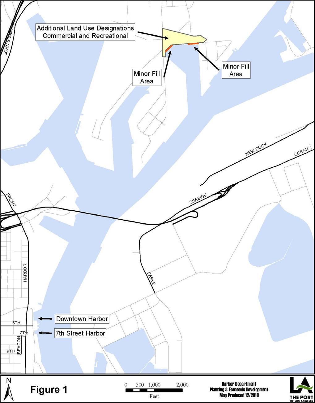
2 2 of 13
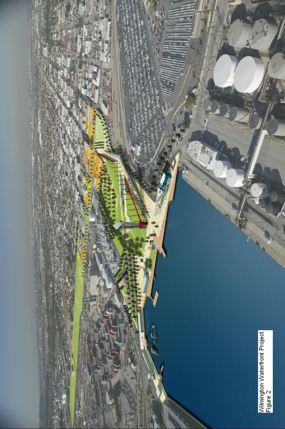
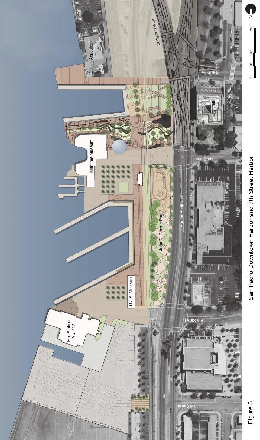
3 COASTAL ACT COMPLIANCE An amendment to the Port Master Plan must follow the same certification and approval process as a Port Master Plan. The California Coastal Act of 1976, Chapter 8, Article 3, Section 30711(a) states, A port master plan that carries out the provisions of this chapter shall be prepared and adopted by each port governing body, and for informational purposes, each city, county, or city and county which has a port within its jurisdiction shall incorporate the certified port master plan in its local coastal program. A port master plan shall include all of the following : 1. The proposed uses of land and water areas, where known Wilmington Waterfront Project This amendment would add Recreational and Commercial land uses to the area immediately behind Berths in Wilmington. This area currently can support a variety of cargo handling activities. The addition of Recreational and Commercial land uses provides for the development of the Wilmington Waterfront Project, which will provide enhanced public access opportunities to the waterfront in the Wilmington district of the Port (Master Planning Area 5). Project elements include the development of approximately seven acres of open space, waterfront promenade, public plazas, and visitor-serving commercial development. Two minor fills totaling approximately 2,200 sf are also proposed at Berths 183 and 186 to improve the existing seawall to accommodate enhanced public access to the waterfront through the development of public viewing piers. The fills are required to address seismic design standards and strengthen the seawall to accommodate public access to the waterfront and allow for the construction of a waterfront promenade and public access pier. Figure 2 presents a rendering of the planned Wilmington Waterfront site. San Pedro Waterfront Two new harbor basins are proposed to be developed in the San Pedro Waterfront Project. The Downtown Harbor is a proposed 1.5 acre water basin located at Berth 85 immediately north of the existing Los Angeles Maritime Museum. The new harbor basin will accommodate tugboats, Port-owned vessels (Port Police vessels), and tall ships. Approximately 137,000 cubic yards of material will be removed to create the new harbor basin. The proposed 7 th Street Harbor will be approximately 0.32 acres in size and will accommodate visiting recreational boaters and tall ships. Approximately 101,000 cubic yards of material will be removed to create the new 7 th Street harbor basin. The total estimated 146,000 cubic yards of material to be removed for the development of 3 of 13
4 4 of 13
5 the two harbor basins will be disposed at various Port upland project sites. Figure 3 presents the planned San Pedro Waterfront improvements. 2. The projected design and location of port land areas, water areas, berthing, and navigation ways and systems intended to serve commercial traffic within the area of jurisdiction of the port governing body. Figure 1 presents the location of the proposed waterfront projects in Wilmington and San Pedro. The proposed fills in Wilmington and harbor basins in San Pedro will not affect commercial traffic in the Port. The fill is necessary to support enhanced public access and will be adjacent to the existing seawall. The proposed new harbor basins, totaling approximately 1.82 acres of new water area, are along the Main Channel in San Pedro and will not impact commercial vessel traffic in the Main Channel. Tugboats currently are berthed along the Main Channel at the site of the proposed Downtown Harbor. With the creation of the Downtown Harbor those tugboats will continue to berth at the entrance to the new harbor. 3. An estimate of the effect of development on habitat areas and the marine environment, a review of existing water quality, habitat areas, and quantitative and qualitative biological inventories, and proposals to minimize and mitigate any substantial adverse impact. The Wilmington Waterfront Development Project Environmental Impact Report (EIR) was certified by the Board of Harbor Commissioners (Board) on June 18, The EIR identified all environmental impacts created by the proposed land use changes and minor fills at Berths 183 and 186. Specifically, significant unavoidable biological impacts include the permanent loss of marine habitat relative to the approximately 2,200 sf of new fills. Mitigation for the loss of the marine habitat include debiting the required credits from the Inner Harbor Mitigation Bank, per the terms and conditions established in the Memorandum of Understanding (MOU) between the Port, California Department of Fish and Game (CDFG), National Marine Fisheries Service (NMFS), and U.S. Fish and Wildlife Service (USFWS). The MOU provides that for each acre of marine habitat impacted within the Inner Harbor the mitigation bank will be debited 0.5 credits. Thus the 0.05 acre of marine habitat impacted in the Inner Harbor will result in a debit from the mitigation bank of credits. No other impacts are identified as a result of the two proposed fills in Wilmington. On September 29, 2009, the Board certified the San Pedro Waterfront Project Environmental Impact Statement/Environmental Impact Report, which identified environmental impacts and mitigation measures related to the two new harbors, including impacts to biological resources. The creation of the Downtown and 7 th Street Harbors would have no significant and unavoidable biological impacts. Significant biological impacts that can be mitigated to less than significant status 5 of 13
6 6 of 13
7 include dredging, filling, and wharf construction activities disrupting local biological communities. Contaminated sediments can potentially be released during dredging that could adversely affect aquatic organisms if toxic substances are present in sediments and suspended in the water column during dredge activities. Mitigation for these biological impacts include sediment testing for contaminants prior to dredging, disposal of dredge material only at upland sites that meet the sediment quality criteria for disposal, monitoring and management of turbidity related to dredge activities, conducting nesting bird surveys prior to the clearing, removal, or grubbing of any vegetation or ground disturbance, and the establishment of a safety zone to protect marine mammals. 4. Proposed projects listed as appealable in Section in sufficient detail to be able to determine their consistency with the policies of Chapter 3 (commencing with Section 30200) of this division. This project has been evaluated with regard to the requirements of Section and found to be non-appealable. 5. Provisions for adequate public hearings and public participation in port planning and development decisions. The Notice of Completion and distribution of Draft Amendment No. 26 was approved by the Los Angeles Board of Harbor Commissioners during the regularly scheduled Board meeting of February 3, The Notice of Completion was mailed to interested persons, organizations, governmental agencies, including the California Coastal Commission, and all Port tenants. A public hearing on the draft amendment will be held during the regularly scheduled Board of Harbor Commissioners meeting on March 17, All comments on the proposed amendment and responses to comments will be submitted to the Coastal Commission as part of the final amendment. A port master plan shall contain information in sufficient detail to allow the commission to determine its adequacy and conformity with the applicable policies of this division. This amendment has been prepared in full compliance with the policies of the California Coastal Act of Coastal Act policies applicable to the proposed amendment are as follows: Section (a) The ports of the State of California constitute one of the state s primary economic and coastal resources and are an essential element of the national maritime industry. 7 of 13
8 (b) The locations of the commercial port districts within the State of California are well established and for many years such areas have been devoted to transportation and commercial, industrial, and manufacturing uses consistent with federal, state and local regulations. Coastal planning requires no change in the number of or location of the established commercial port districts. Existing ports, including the Humboldt Bay Harbor, Recreation, and Conservation District, shall be encouraged to modernize and construct necessary facilities within their boundaries in order to minimize or eliminate the necessity for future dredging and filling to create new ports in new areas of the state. This addition of Commercial and Recreational land use designations to the area adjacent to Berths increase public access and visitor serving facilities to the waterfront. The minor fills to create 2,200 sf of land would improve the existing seawall at Slip 5 for waterfront promenade improvements that include viewing piers and enhance public access to the waterfront. The new harbor basins in San Pedro, located at Berths 83 and 85, increase public access to the waterfront and accommodate a variety of vessels, including tugboats, historic ships, and Port-owned vessels. Both the Wilmington and San Pedro Waterfront projects provide public access in certain areas of the Port, including in San Pedro, adjacent to downtown San Pedro. Focusing public access in these areas allows the Port to continue to develop cargo handling activities in the remaining areas of the Port, thereby minimizing or eliminating the need to create new ports in new areas of the state. Section (a) Water areas may be diked, filled, or dredged when consistent with a certified port master plan only for the following: (2) New or expanded facilities or waterfront land for port-related facilities. The minor fills and new harbor basins proposed by the amendment all support enhanced public access to the waterfront. The two fills in Wilmington will allow for waterfront promenade improvements and the development of public access piers at the site. The new harbor basins in San Pedro will create additional water areas for the berthing of tugboats, historic tall ships, and visiting recreational boaters as well as enhanced public access to the waterfront. A public plaza and promenade will surround the planned new harbor basins. (8) Minor fill for improving shoreline appearance or public access to the water. 8 of 13
9 The minor fills at Berths 183 and 186 allow for development of a waterfront promenade for public access to the waterfront in Wilmington. The existing seawall has two locations, Berth 183 and Berth 186 that require strengthening with new sheet pile walls. The strengthening is required to address seismic issues and accommodate public access to the waterfront through the development of the waterfront promenade and public viewing pier. (c) Dredging shall be planned, scheduled, and carried out to minimize disruption to fish and bird breeding and migrations, marine habitats, and water circulation. Bottom sediments or sediment elutriate shall be analyzed for toxicants prior to dredging or mining, and where water quality standards are met, dredge spoils may be deposited in open coastal water sites designated to minimize potential adverse impacts on marine organisms, or in confined coastal waters designated as fill sites by the master plan where such spoil can be isolated and contained, or in fill basins on upland sites. Dredge material shall not be transported from coastal waters into estuarine or fresh water areas for disposal. Efforts to minimize impacts from dredging the new harbors on disruption to fish and bird breeding and migrations, marine habitats, and water circulation include the following mitigation measures: turbidity management, establishment of a safety zone to protect marine mammals during in-water construction activities, and sediment testing and disposal that meet sediment quality criteria at an approved upland location. The fill material will be used to support various Port upland projects. Section In addition to the other provisions of this chapter, the policies contained in this section shall govern filling seaward of the mean high tide line within the jurisdiction of ports: (a) The water area to be filled shall be the minimum necessary to achieve the purpose of the fill. The estimated 2,200 sf of fills at Berths 183 and 186 is the minimum necessary to achieve the purpose of the fill. The existing seawall along the Wilmington Waterfront project site does not meet current seismic design standards. In order to construct the proposed waterfront improvements and safely accommodate public access, the seawall has to be strengthened or replaced. For the middle section of seawall (approximately 1,200 linear feet), deep soil mixing will be employed behind the seawall to strengthen the existing soil and allow the seawall to remain. Due to the proximity of the existing Banning s Landing community building at Berth 186 and the existing substructure at Berth 183, deep soil mixing is not an option. For these areas, a new sheet pile wall will be driven 4 feet outboard of the existing seawall, with the area between filled in order to 9 of 13
10 strengthen the existing seawall structure. Approximately 550 lineal feet of sheet piling will be required for the two sites, resulting in a total fill amount of approximately 2,200 sf. (b) The nature, location, and extent of any fill, including the disposal of dredge spoils within an area designated for fill, shall minimize harmful effects to coastal resources, such as water quality, fish or wildlife resources, recreational resources, or sand transport systems, and shall minimize reductions of the volume, surface area, or circulation of water. As described above, the volume of the proposed fills at Berths 183 and 186 are the minimum necessary to address seismic design standards and accommodate public access. The Wilmington Waterfront Development Project FEIR determined that all impacts related to the minor fills at Berths 183 and 186 are less than significant. No measurable alteration of the volume of water in the harbor is expected and the small change in volume would not alter the utility of the water. Mitigation measures include debiting the required credits from the Inner Harbor Mitigation Bank, at a ratio of 0.5 credits for each acre of marine habitat impacted. Thus, the 2,200 sf (0.05 acres) of lost marine habitat will result in a debit of credits from the mitigation bank. (d) The fill is consistent with navigational safety. The minor fills at Berths 183 and 186 have no impact on navigational safety. Section All port-related developments shall be located, designed and constructed so as to: (a) Minimize substantial adverse environmental impacts The Wilmington Waterfront Development Project EIR identified environmental impacts created by the project. The development of the proposed improvements requiring the Recreational and Commercial land use designations (open space, waterfront promenade, plazas, and visitor-serving commercial development) and the fills incur significant environmental impacts with respect to construction emissions, levels of Toxic Air Contaminants (TACs), Greenhouse Gas (GHG) emissions, loss of marine habitat, increased potential for loss of unknown archaeological resources, increased exposure to seismic hazards, increased potential for release of toxic substances from prior operations, and construction noise impacts. Mitigation measures have been adopted to minimize these impacts, including: 10 of 13
11 Air Quality: Mitigation measures include cleanest available harbor craft engine standards, electric dredging equipment, fleet modernization for onroad trucks, fleet modernization for construction equipment, dust controls for earth moving activities, best management practices on construction equipment, energy efficiency measures, renewable energy measures, water conservation and efficiency measures, solid waste measures, land use measures, and transportation and motor vehicle measures. Biological Resources: Mitigation measures include pile driving monitoring, where a qualified biologist will monitor the area and halt pile driving in the event of fish kills or the presence of marine mammals with 100 meters of the pile driving, and debiting the required credits from the Inner Harbor Mitigation Bank, at a ratio of 0.5 credits for each acre of marine habitat impacted. Thus, the 2,200 square feet (0.05 acres) of lost marine habitat will result in a debit of credits from the mitigation bank. Cultural Resources: Mitigation measures include restrictions on excavations if cultural artifacts are found. Geological Measures: Mitigation measures include incorporation of seismic design recommendations. Groundwater and Soils: Mitigation measures include site remediation and contamination contingency planning. Noise: Mitigation measures include the use of temporary noise barriers, restricted construction hours, idling prohibitions, quiet equipment selections, and community notification. Ground and Marine Transportation: Mitigation measures include traffic control planning and construction of additional through and turn lanes at a number of intersections in the proposed Project vicinity. Water Quality: The project requires the use of silt curtains extending from the bottom to above the waterline so as to enclose all of the waters where inwater work will occur to manage turbidity. The San Pedro Waterfront Project EIS/EIR identified environmental impacts created by the project. The development of the new harbors will result in significant environmental impacts with respect to construction and operation emissions, levels of TACs, GHG emissions, loss of marine habitat, increased potential for loss of unknown archaeological resources, increased exposure to seismic hazards, increased potential for release of toxic substances from prior operations, construction noise impacts, increased potential for release of hazardous materials, loss of visitor-oriented opportunities during construction, disruption of vehicular and nonmotorized travel during construction, and utility disruption. Mitigation measures have been adopted to minimize these impacts, including: Air Quality: Mitigation measures include cleanest available harbor craft engine standards, electric dredging equipment, fleet modernization for onroad trucks, fleet modernization for construction equipment, dust controls for earth 11 of 13
12 moving activities, best management practices on construction equipment, Alternative Maritime Power for tugboats, engine standards for tugboats, tugboat idling reduction. Biological Resources: Mitigation measures include managing turbidity, nesting bird surveys, avoiding marine mammals, sediment testing and disposal at disposal sites that meet sediment quality criteria, or an approved upland location. The material will be used within the Port to support various Port upland projects. Cultural Resources: Mitigation measure include treatment planning and archaeological testing for Mexican Hollywood artifacts, monitor ground disturbance in the vicinity of known archaeological sites, restrictions on excavations if cultural artifacts are found, and development of programs to mitigate impacts on nonrenewable paleontologic resources. Geological Measures: Mitigation measures include emergency response planning. Groundwater and Soils: Mitigation measures include site remediation, abandonment and removal of affected pipeline, and contamination contingency planning. Noise: Mitigation measures include temporary noise barriers, use of the softstart pile driving, in which the hammer is operated at less than full capacity with no less than a 1-minute interval between each strike for a 5-minute period, and quiet equipment selection. Recreation: Mitigation measures include maintenance of pedestrian access, vehicle access, parking, vessel access, boat ramp access, access to open waters, and docking space during construction, Ground and Marine Transportation: Mitigation measures include traffic control planning, and offset loss parking elsewhere in the vicinity. Utilities and Public Services: Mitigation measures include coordination with law enforcement agencies, use of recycled construction materials, water conservation and wastewater reduction measures, and energy conservation measures. Water Quality: As a project requirement, during dredge operations, an integrated multi-parameter monitoring program will be implemented by the Port to adaptively manage turbidity and achieve water quality objectives. Potential responses to exceedances of acceptable levels of turbidity include the use of a silt curtain or alteration of the dredging method. (c) Give highest priority to the use of existing land space within harbors for port purposes, including, but not limited to, navigational facilities, shipping industries, and necessary support and access facilities. The additional land use designations, minor fills, and two new harbors are for port purposes; specifically to provide for enhanced public access to the waterfront. The proposed development of these public access improvements along portions of the San Pedro and Wilmington waterfronts will not impact existing or planned cargo handling activities. 12 of 13
13 (d) Provide for other beneficial uses consistent with the public trust, including, but not limited to, recreation and wildlife habitat uses, to the extent feasible. The proposed waterfront elements addressed in the draft amendment provide for recreational and public access opportunities to the waterfront. The land use designations and proposed fills will provide landside recreational opportunities through the provision of open space and public plazas and increased public access to the waterfront through the development of public piers. Waterside recreational opportunities are provided through the creation of the new harbor basins which will provide berthing access for visiting recreational boaters and visiting tall ships. 13 of 13
Port of Long Beach Port Master Plan Overview December 22, 2008
 Port of Long Beach Port Master Plan Overview December 22, 2008 PORT OF LONG BEACH PORT MASTER PLAN OVERVIEW INTRODUCTION In 1978 the California Coastal Commission certified the Port of Long Beach Port
Introduction. Chapter 3 Modifications to the Draft EIS/EIR
 1 2 Chapter 3 Modifications to the Draft EIS/EIR 3 4 5 6 7 8 9 10 11 12 13 14 15 16 17 18 19 20 21 22 23 24 25 26 27 28 29 30 31 32 Introduction This chapter of the document addresses modifications to
COMPARISON OF ALTERNATIVES
 COMPARISON OF ALTERNATIVES 0 0. Introduction This chapter compares the proposed Project to the six alternatives identified in Chapter, Project Description. Both CEQA and NEPA require analysis of a reasonable
Chapter 4 ALTERNATIVES COMPARISON
 Chapter 4 ALTERNATES COMPARSON 4.1 NTRODUCTON This chapter presents a comparison of the alternatives that were considered during preparation of this Draft ES/ER. Section 1.6 of this Draft ES/ER presents
PUBLIC AND AGENCY INVOLVEMENT
 CHAPTER 5 PUBLIC AND AGENCY INVOLVEMENT Since late 2010, several types of public and agency participation have occurred as a part of the project design and the environmental review process, pursuant to
DRAFT MITIGATION MONITORING AND REPORTING PROGRAM Document considered draft until Board considers document
 DRAFT MITIGATION MONITORING AND REPORTING PROGRAM Document considered draft until Board considers document Terminal Improvements Project Environmental Impact Statement/ Environmental Impact Report Prepared
SPECIAL PUBLIC NOTICE
 SPECIAL PUBLIC NOTICE LOS ANGELES DISTRICT NOTICE OF AVAILABILITY OF A FINAL ENVIRONMENTAL IMPACT STATEMENT/ENVIRONMENTAL IMPACT REPORT Public Notice/Application No.: 2006-2062-JWM Comment Period: November
1.0 REQUEST. SANTA BARBARA COUNTY PLANNING COMMISSION Determination of Flood Control Easement in Carpinteria Marsh
 SANTA BARBARA COUNTY PLANNING COMMISSION 65402 Determination of Flood Control Easement in Carpinteria Marsh Deputy Director: Dave Ward Staff Report Date: April 11, 2008 Division: Development Review South
3.8 LAND USE Introduction Environmental Setting Regional Setting PMPU Area
 . LAND USE 0.. Introduction This section describes the environmental setting for land use within the PMPU area, identifies applicable regulations, and analyzes the potential impacts that could result from
Appendix M. Criteria, Measures and Indicators for Effects Assessment
 Appendix M Criteria, Measures and Indicators for Effects Assessment Appendix M. Criteria, Measures and Indicators for Effects Assessment Objective 1: Naturalization Changes to Aquatic Habitat Disruption,
PUBLIC NOTICE LOS ANGELES DISTRICT. APPLICATION FOR PERMIT Port of Los Angeles Berths : Wilmington Waterfront Promenade
 PUBLIC NOTICE U.S. ARMY CORPS OF ENGINEERS LOS ANGELES DISTRICT BUILDING STRONG APPLICATION FOR PERMIT Port of Los Angeles Berths 182-186: Wilmington Waterfront Promenade Public Notice/Application No.:
Appendix D1 Screening Analysis
 Appendix D Screening Analysis of Additional Resource Areas for Consideration in the CS SEIR due to Assumed Incremental Increase in Terminal Throughput under the Revised Project Appendix D1 Screening Analysis
U.S. ARMY CORPS OF ENGINEERS BUILDING STRONG LOS ANGELES DISTRICT
 PUBLIC NOTICE U.S. ARMY CORPS OF ENGINEERS BUILDING STRONG LOS ANGELES DISTRICT APPLICATION FOR PERMIT/ NOTICE OF AVAILABILITY FOR A DRAFT ENVIRONMENTAL IMPACT STATEMENT / PUBLIC HEARING Public Notice/Application
Public Notice. In Reply Refer To: Corps File No. LRE S18 Date: October 1, 2018 Expires: October 19, 2018
 US Army Corps of Engineers Detroit District Public Notice Applicant: Barrett Boat Works In Reply Refer To: Corps File No. LRE-1983-570234-S18 Date: October 1, 2018 Expires: October 19, 2018 Proposed marina
Berths [Everport] Container Terminal Improvements Project Draft EIS/EIR Public Meeting
![Berths [Everport] Container Terminal Improvements Project Draft EIS/EIR Public Meeting](/thumbs/76/73451102.jpg "Berths [Everport] Container Terminal Improvements Project Draft EIS/EIR Public Meeting") Berths 226-236 [Everport] Container Terminal Improvements Project Draft EIS/EIR Public Meeting U.S. Army Corps of Engineers Los Angeles Harbor Department May 10, 2017 Opening Remarks Agenda Christopher
Berths 226-236 [Everport] Container Terminal Improvements Project Draft EIS/EIR Public Meeting U.S. Army Corps of Engineers Los Angeles Harbor Department May 10, 2017 Opening Remarks Agenda Christopher
Chapter 5 Regulatory Coordination and Compliance
 Chapter 5 Regulatory Coordination and Compliance This chapter provides an update on the federal, state, and local laws and regulations that required the City to coordinate with regulatory agencies to obtain
Beneficial Reuse of Dredged Sediments in the Middle Harbor Slip 1 Fill
 Beneficial Reuse of Dredged Sediments in the Middle Harbor Slip 1 Fill Port of Long Beach Category: Environmental Enhancement Heather Tomley Director of Environmental Planning Port of Long Beach 4801 Airport
SECTION 9.0 Effects Found Not To Be Significant
 SECTION 9.0 Effects Found Not To Be Significant 9.0 EFFECTS FOUND NOT TO BE SIGNIFICANT The City of Santa Clarita conducted an Initial Study in April 2006 to determine significant effects of the proposed
u.s. ARMY CORPS OF ENGINEERS, LOS ANGELES DISTRICT RECORD OF DECISION FOR THE BERTHS CONTAINER TERMINAL PROJECT PORT OF LOS ANGELES, CALIFORNIA
 CESPL-RG 10 July 2009 u.s. ARMY CORPS OF ENGINEERS, LOS ANGELES DISTRICT RECORD OF DECISION FOR THE BERTHS 97-109 CONTAINER TERMINAL PROJECT PORT OF LOS ANGELES, CALIFORNIA 1. Introduction: a. Location:
Table of Contents. List of Tables. 11. Advantages and Disadvantages
 Table of Contents 11. Advantages and Disadvantages... 11-1 page List of Tables... 11-1 11. Advantages and Disadvantages The overall advantages and disadvantages of the DMNP are articulated, summarized
Green Port Long Beach
 Green Port Long Beach Green Port Policy Update May 2010 Presented by Richard Cameron Director of Environmental Planning Green Port Policy Protect the community from negative Port impacts Distinguish Port
3.8 LAND USE Introduction Environmental Setting
 3.8 LAND USE 3. Affected Environment and Environmental Analysis 3.8 LAND USE 3.8.1 Introduction This section provides a description of the existing land uses within and adjacent to the six disposal sites
Introduction: Jason Giffen, Assistant Vice President, Planning and Green Port
 Introduction: Jason Giffen, Assistant Vice President, Planning and Green Port Today I want to talk about how the Port of San Diego is preparing for it s future through planning, implementation, and exploration.
6. Cumulative Impacts
 6.1 OVERVIEW Section 15355 of the California Environmental Quality Act (CEQA) Guidelines defines cumulative impacts as: "...two or more individual effects which when considered together, are considerable
Indirect and Cumulative Effects
 Chapter 21: Indirect and Cumulative Effects 21-1 INTRODUCTION The federal Council on Environmental Quality s (CEQ) regulations implementing the procedural provisions of the National Environmental Policy
Berths [Everport] Container Terminal Improvements Project Environmental Impact Report
![Berths [Everport] Container Terminal Improvements Project Environmental Impact Report](/thumbs/79/79899093.jpg "Berths [Everport] Container Terminal Improvements Project Environmental Impact Report") DRAFT FINDINGS OF FACT AND STATEMENT OF OVERRIDING CONSIDERATIONS Document considered draft until Board review and approval Terminal Improvements Project Environmental Impact Report Prepared by: Los Angeles
DRAFT FINDINGS OF FACT AND STATEMENT OF OVERRIDING CONSIDERATIONS Document considered draft until Board review and approval Terminal Improvements Project Environmental Impact Report Prepared by: Los Angeles
DEPARTMENT OF THE ARMY CORPS OF ENGINEERS, MOBILE DISTRICT P.O. BOX 2288 MOBILE, AL
 DEPARTMENT OF THE ARMY CORPS OF ENGINEERS, MOBILE DISTRICT P.O. BOX 2288 MOBILE, AL 36628-0001 CESAM RD-A April 15, 2018 PUBLIC NOTICE NO. SAM-2018-01191-DCH JOINT PUBLIC NOTICE U.S. ARMY CORPS OF ENGINEERS
PUBLIC NOTICE REQUEST FOR PERMISSION TO ALTER A U.S. ARMY CORPS OF ENGINEERS PROJECT PURSUANT TO 33 U.S.C. SECTION 408
 DEPARTMENT OF THE ARMY CORPS OF ENGINEERS, NEW ORLEANS DISTRICT 7400 LEAKE AVENUE NEW ORLEANS, LOUISIANA 70118 REPLY TO ATTENTION OF Regional Planning and Environmental Division South Environmental Compliance
Berth [China Shipping] Container Terminal Project - Environmental Review -
![Berth [China Shipping] Container Terminal Project - Environmental Review -](/thumbs/73/69355525.jpg "Berth [China Shipping] Container Terminal Project - Environmental Review -") Berth 97-19 [China Shipping] Container Terminal Project - Environmental Review - A Re-circulated Draft Environmental Impact Statement/Environmental Impact Report (DEIS/EIR) on the Berth 97-19 [China Shipping]
Berth 97-19 [China Shipping] Container Terminal Project - Environmental Review - A Re-circulated Draft Environmental Impact Statement/Environmental Impact Report (DEIS/EIR) on the Berth 97-19 [China Shipping]
Mobile Air Toxic Exposure Study (MATES)
") Christopher Cannon, Director of Environmental Management Trade, Commerce & Technology Committee Special Meeting Port of Los Angeles - November 17, 2015 Mobile Air Toxic Exposure Study (MATES) Change in
Christopher Cannon, Director of Environmental Management Trade, Commerce & Technology Committee Special Meeting Port of Los Angeles - November 17, 2015 Mobile Air Toxic Exposure Study (MATES) Change in
Appendix D. San Francisco Bay Plan Consistency Analysis
 Appendix D San Francisco Bay Plan Consistency Analysis San Francisco Bay Plan Consistency Analysis Page 1 of 9 Protection of the Shoreline Policy 2: Riprap revetments, the most common shoreline protective
Analysis of Alternatives
 Chapter Analysis of Alternatives 0. Introduction This chapter presents a comparison of alternatives to the proposed Project. Various Project alternatives were considered during preparation of this Draft
Memorandum. California public trust law governs the administration of tidelands and submerged lands in several ways:
 Memorandum To: Piers 30-32 Citizen s Advisory Committee ( CAC ) Land Use Subcommittee From: Brad Benson and Diane Oshima Date: January 10, 2013 Re: Public Trust Doctrine and BCDC The purpose of this memo
RE-ISSUED NOTICE OF PREPARATION SUBSEQUENT ENVIRONMENTAL IMPACT REPORT
 RE-ISSUED NOTICE OF PREPARATION SUBSEQUENT ENVIRONMENTAL IMPACT REPORT Date: January 5, 2010 Subject: Re-Issue Notice of Intent to Prepare a Draft Subsequent Environmental Impact Report Project Title:
Prepared by: Los Angeles Harbor Department 425 S. Palos Verdes Street San Pedro, CA (310)
") ADDENDUM TO THE SAN PEDRO WATERFRONT PROJECT ENVIRONMENTAL IMPACT REPORT FOR THE JANKOVICH COMPANY RELOCATION PROJECT [SCH No. 2005061041, APP No. 160815-117] Prepared by: Los Angeles Harbor Department
ADDENDUM TO THE SAN PEDRO WATERFRONT PROJECT ENVIRONMENTAL IMPACT REPORT FOR THE JANKOVICH COMPANY RELOCATION PROJECT [SCH No. 2005061041, APP No. 160815-117] Prepared by: Los Angeles Harbor Department
Executive Summary. and appendices, as well as. can be obtained by calling (206) or by sending an e mail to
 or by sending an e mail to") Executive Summary The City of Seattle (City), through the Seattle Department of Transportation (SDOT), is replacing the Elliott Bay Seawall along the shoreline of downtown Seattle. The seawall protects
Executive Summary The City of Seattle (City), through the Seattle Department of Transportation (SDOT), is replacing the Elliott Bay Seawall along the shoreline of downtown Seattle. The seawall protects
Gateway Infrastructure Development Programs in Urban Centers on the west coast of North America
 November 16, 2011 Gateway Infrastructure Development Programs in Urban Centers on the west coast of North America Capacity Improvements Congestion & Air Emissions Mitigation & Community Amenities Mark
3.12 UTILITIES Introduction Environmental Setting
 3.12 UTILITIES 3. Affected Environment and Environmental Analysis 3.12 UTILITIES 3.12.1 Introduction This section addresses the potential for impacting public utilities within the Port, the Main Channel,
THIS IS NOT A PAID ADVERTISEMENT. Public Notice. Public Notice No. CENAP-OP-R February 2, 2018
 THIS IS NOT A PAID ADVERTISEMENT Public Notice Wanamaker Building 100 Penn Square East Philadelphia, PA 19107-3390 ATTN: CENAP-OP-R Public Notice No. Date CENAP-OP-R-2015-1060-24 February 2, 2018 Application
Central San Pedro Neighborhood Council Port Committee Meeting February 19, 2014 Augie Bezmalinovich Port of Los Angeles
 Central San Pedro Neighborhood Council Port Committee Meeting February 19, 2014 Augie Bezmalinovich Port of Los Angeles 1. Call to Order 2. Introduction of Guests 3. Consideration of Agenda 4. Port of
Ports of Long Beach and Los Angele Summary of Key Water and Sediment Quality Programs & Projects. Common and/or Joint POLB/POLA Programs & Projects
 Ports of Long Beach and Los Angele Summary of Key Water and Sediment Quality Programs & Projects Common and/or Joint POLB/POLA Programs & Projects Bight 08 Regional Survey Bight 08 is a regional survey
Venice Pumping Plant Dual Force Main Project Draft EIR 1.0 I NTRODUCTION
 1.0 I NTRODUCTION 1.1 PURPOSE OF THE EIR The purpose of an Environmental Impact Report (EIR), as defined in Section 15121(a) of the State Guidelines for the implementation of the California Environmental
PUBLIC NOTICE ADDITIONAL INFORMATION PERTAINING TO DEPARTMENT OF THE ARMY PERMIT APPLICATION
 PUBLIC NOTICE ADDITIONAL INFORMATION PERTAINING TO DEPARTMENT OF THE ARMY PERMIT APPLICATION LOS ANGELES DISTRICT Public Notice/Application No.: 2003-01029-SDM Review Period: April 23, 2009 through May
Chapter 6 Avoidance, Minimization, and Mitigation
 Chapter 6 Avoidance, Minimization, and Mitigation This chapter provides a summary of the mitigation measures that the City could implement to avoid, minimize, rectify, or compensate for impacts from the
CHAPTER 3 ENVIRONMENTAL SETTING AND PROJECT IMPACTS
 CHAPTER 3 ENVIRONMENTAL SETTING AND PROJECT IMPACTS 3.0 INTRODUCTION This chapter describes the area of influence, setting (environmental and regulatory), methodology, potential impacts, and mitigation
WA Department of Ecology SEA Program Post Office Box Olympia, WA Telephone: (360) ATTN: Federal Permit Coordinator
 ATTN: Federal Permit Coordinator") US Army Corps of Engineers Seattle District Joint Public Notice Application for a Department of the Army Permit and a Washington Department of Ecology Water Quality Certification and/or Coastal Zone Management
US Army Corps of Engineers Seattle District Joint Public Notice Application for a Department of the Army Permit and a Washington Department of Ecology Water Quality Certification and/or Coastal Zone Management
FINAL ENVIRONMENTAL IMPACT STATEMENT. Final EIS in Focus
 FINAL ENVIRONMENTAL IMPACT STATEMENT Final EIS in Focus 03.2013 The Elliott Bay Seawall Project The City of Seattle, through the Seattle Department of Transportation (SDOT), is proposing to construct the
Revitalization Plan and EIR Board of Supervisors Hearing January 31, 2006
 Dana Point Harbor Revitalization Plan and EIR Board of Supervisors Hearing January 31, 2006 Existing Conditions 2 3 4 Dana Point Harbor Drive Golden Lantern Proposed Commercial Core Plan (PA 1 & 2) 5 Environmental
3.0 PROJECT DESCRIPTION
 LSA ASSOCIATES, INC. OCTOBER 2009 DRAFT ENVIRONMENTAL IMPACT REPORT ALAMITOS BAY MARINA REHABILITATION PROJECT CITY OF LONG BEACH 3.0 PROJECT DESCRIPTION 3.1 PROJECT LOCATION AND SITE DESCRIPTION The Alamitos
Project Overview. Northwest Innovation Works LLC and the Port of Kalama propose to develop and operate
 Project Overview Northwest Innovation Works LLC and the Port of Kalama propose to develop and operate a natural gas-tomethanol production plant and storage facilities, and a new marine terminal, in the
EVALUATION OF SECTION 404(b)(1) GUIDELINES (SHORT FORM)
(1) GUIDELINES (SHORT FORM)") EVALUATION OF SECTION 404(b)(1) GUIDELINES (SHORT FORM) PROPOSED PROJECT: Matagorda Ship Channel Deficiency Study and Environmental Assessment (Nov 2017) 1. Review of Compliance (230.10(a)-(d)) A review
EVALUATION OF SECTION 404(b)(1) GUIDELINES (SHORT FORM) PROPOSED PROJECT: Matagorda Ship Channel Deficiency Study and Environmental Assessment (Nov 2017) 1. Review of Compliance (230.10(a)-(d)) A review
PUBLIC NOTICE PROJECT: U.S. Coast Guard Base Alameda Boat Basin Dredging Project
 Regulatory Division 1455 Market Street, 16 th Floor San Francisco, CA 94103-1398 SAN FRANCISCO DISTRICT PUBLIC NOTICE PROJECT: U.S. Coast Guard Base Alameda Boat Basin Dredging Project PUBLIC NOTICE NUMBER:
PUBLIC NOTICE Application for Permit
 PUBLIC NOTICE Application for Permit Issue Date: March 4, 2016 Expiration Date: April 4, 2016 US Army Corps of Engineers No: NWP-2015-432 30-Day Notice Oregon Department of State Lands No: 58511 Interested
I202. Central Wharves Precinct
 I202. Central Wharves Precinct I202.1. Precinct description The zoning of the land within the Central Wharves Precinct is the Business City Centre Zone and the underlying zoning of the part of the Central
CITY OF DANA POINT AGENDA REPORT KYLE BUTTERWICK, DIRECTOR OF COMMUNITY DEVELOPMENT
 06/13/11 Page 1 Item #18 CITY OF DANA POINT AGENDA REPORT Reviewed By: DH X CM X CA DATE: JUNE 13, 2011 TO: FROM: SUBJECT: CITY MANAGER/CITY COUNCIL KYLE BUTTERWICK, DIRECTOR OF COMMUNITY DEVELOPMENT CALIFORNIA
EXECUTIVE SUMMARY. Introduction. Water Quality and Sediment Background
 EXECUTIVE SUMMARY Introduction The Port of Los Angeles and the Port of Long Beach (Ports) have as their goals for the Water Resources Action Plan (WRAP) 1) to ensure that the operations and programs of
F5. Coastal Minor Port Zone
 F5. Coastal Minor ort Zone F5.1. Zone description Auckland has a range of water transport facilities in addition to the city centre port that are important for business and industry. Maintaining such sites
SAN FRANCISCO DISTRICT PUBLIC NOTICE. PROJECT: Eureka Forest Products Dock Maintenance Dredging
 SAN FRANCISCO DISTRICT PUBLIC NOTICE PROJECT: Eureka Forest Products Dock Maintenance Dredging Regulatory Division 1455 Market Street, 16 th Floor San Francisco, CA 94103-1398 PUBLIC NOTICE NUMBER: 2005-295360
Chapter 4 Cumulative Effects
 Chapter 4 This chapter reevaluates the likely level of cumulative effects to which the Elliott Bay Seawall Project could contribute, given the proposed changes to the project, and determines whether these
PORT OF LOS ANGELES CHANNEL DEEPENING PROJECT 1. Introduction
 1. INTRODUCTION This chapter presents background and introductory information for completing the Channel Deepening Project (Proposed Action) at the Port of Los Angeles (Port or POLA). The Proposed Action
PUBLIC NOTICE NO. FP13-AB03-05 August 30, 2013 CESAM-PD-EC JOINT PUBLIC NOTICE
 DEPARTMENT OF THE ARMY MOBILE DISTRICT, CORPS OF ENGINEERS P.O. BOX 2288 MOBILE, ALABAMA 36628-0001 REPLY TO ATTENTION OF: JOINT PUBLIC NOTICE U. S. ARMY CORPS OF ENGINEERS, MOBILE DISTRICT AND FLORIDA
Preliminary Project Assessment
 DISCLAIMERS: Date: March 14, 2014 Case No.: 2014.0097U Project Address: Third Street Crossing of Islais Creek Block/Lot: Public Right-of-Way Zoning: Not Applicable Area Plan: Not Applicable Project Sponsor:
GREAT KILLS HARBOR, STATEN ISLAND, NEW YORK FEDERAL NAVIGATION PROJECT MAINTENANCE DREDGING
 Public Notice In replying refer to: Public Notice No. GREAT KILLS HARBOR FY13 Published: April 30, 2013, Expires: May 30, 2013 New York District 26 Federal Plaza New York, N.Y. 10278 ATTN: CENAN-OP-ST
PUBLIC NOTICE PROJECT: Paradise Cay Yacht Harbor Maintenance Dredging
 SAN FRANCISCO DISTRICT PUBLIC NOTICE PROJECT: Paradise Cay Yacht Harbor Maintenance Dredging Regulatory Division 1455 Market Street, 16 th Floor San Francisco, CA 94103-1398 PUBLIC NOTICE NUMBER: 2015-00034N
Appendix 1 CWA Section 404 Compliance Forms Section 404(b)(1) Guideline Short Form and Coastal Zone Consistency
(1) Guideline Short Form and Coastal Zone Consistency") Appendix 1 CWA Section 404 Compliance Forms Section 404(b)(1) Guideline Short Form and Coastal Zone Consistency HSC PDR for HSC Flare at Bayport Ship Channel Environmental Assessment This page left intentionally
Appendix 1 CWA Section 404 Compliance Forms Section 404(b)(1) Guideline Short Form and Coastal Zone Consistency HSC PDR for HSC Flare at Bayport Ship Channel Environmental Assessment This page left intentionally
SEPTEMBER 18, 2018 SUBMITTED TO: STATE OF NEW YORK DEPARTMENT OF STATE COASTAL ZONE MANAGEMENT PROGRAM
 COASTAL ZONE MANAGEMENT CONSISTENCY DETERMINATION FOR THE IMPROVEMENT DREDGING OF THE NEW HAVEN HARBOR FEDERAL NAVIGATION PROJECT (NEW HAVEN, CONNECTICUT) SEPTEMBER 18, 2018 SUBMITTED TO: STATE OF NEW
Environmental Restoration in Harbor and Port Areas
 Environmental Restoration in Harbor and Port Areas John Scandura, Branch Chief California Dept. of Toxic Substances Control Brownfields & Environmental Restoration Program Cypress, California California
INVITATION FOR BIDS SAN FRANCISCO BAY AREA WATER EMERGENCY TRANSPORTATION AUTHORITY
 INVITATION FOR BIDS SAN FRANCISCO BAY AREA WATER EMERGENCY TRANSPORTATION AUTHORITY NORTH BAY OPERATIONS AND MAINTENANCE FACILITY PILE RECONFIGURATION PROJECT IFB #17-020 ATTACHMENT B REGULATORY PERMIT
PUBLIC NOTICE PROJECT: Port of Redwood City Municipal Marina and F-Dock Maintenance and New-work Dredging Project
 SAN FRANCISCO DISTRICT PUBLIC NOTICE PROJECT: Port of Redwood City Municipal Marina and F-Dock Maintenance and New-work Dredging Project Regulatory Division 1455 Market Street, 16 th Floor San Francisco,
SAN FRANCISCO DISTRICT PUBLIC NOTICE PROJECT: City of Eureka Maintenance Dredging
 SAN FRANCISCO DISTRICT PUBLIC NOTICE PROJECT: City of Eureka Maintenance Dredging Regulatory Division 1455 Market Street, 16 th Floor San Francisco, CA 94103-1398 PUBLIC NOTICE NUMBER: 1996-222150 PUBLIC
A. INSTRUCTIONS (Please print or type all answers)
") 1051 Boston Post Road, Rye, New York 10580 Phone: (914) 967-7167 Fax (914) 967-4641 www.ci.rye.ny.us\planning.htm A. INSTRUCTIONS (Please print or type all answers) 1. Applicants or in the case of direct
1051 Boston Post Road, Rye, New York 10580 Phone: (914) 967-7167 Fax (914) 967-4641 www.ci.rye.ny.us\planning.htm A. INSTRUCTIONS (Please print or type all answers) 1. Applicants or in the case of direct
Public Notice U.S. ARMY CORPS OF ENGINEERS, GALVESTON DISTRICT AND TEXAS COMMISSION ON ENVIRONMENTAL QUALITY
 Public Notice U.S. Army Corps Permit Application No: SWG-2007-00247 Of Engineers Date Issued: 26 September 2017 Galveston District Comments Due: 26 October 2017 U.S. ARMY CORPS OF ENGINEERS, GALVESTON
ORDINANCE NO. HD- AN ORDINANCE OF THE BOARD OF HARBOR COMMISSIONERS OF THE CITY OF LONG BEACH AMENDING ORDINANCE NO. HD-1357, DESIGNATED
 ORDINANCE NO. HD- AN ORDINANCE OF THE BOARD OF HARBOR COMMISSIONERS OF THE CITY OF LONG BEACH AMENDING ORDINANCE NO. HD-, DESIGNATED TARIFF NO., BY ADDING SECTION, AN INFRASTRUCTURE CARGO FEE OFFICE OF
CESPL-RG 16 February 2010
 CESPL-RG 16 February 2010 U.S. ARMY CORPS OF ENGINEERS, LOS ANGELES DISTRICT RECORD OF DECISION FOR THE PORT OF LONG BEACH MIDDLE HARBOR REDEVELOPMENT PROJECT I. Introduction: A. Location: The proposed
PUBLIC NOTICE PROJECT: Larkspur Marina Maintenance Dredging
 SAN FRANCISCO DISTRICT PUBLIC NOTICE PROJECT: Larkspur Marina Maintenance Dredging Regulatory Division 1455 Market Street, 16 th Floor San Francisco, CA 94103-1398 PUBLIC NOTICE NUMBER: 2015-00036N PUBLIC
Appendix H: Construction Impacts H-5 Dredged Materials Management Alternatives Analysis
 Appendix H: Construction Impacts H-5 Dredged Materials Management Alternatives Analysis Dredged Material Management Alternatives Analysis A. INTRODUCTION The Tappan Zee Hudson River Crossing Project proposes
ATTACHMENT 2 PROJECT NEED AND JUSTIFICATION
 ATTACHMENT 2 PROJECT NEED AND JUSTIFICATION INTRODUCTION The Project includes providing erosion control and shoreline stabilization measures including beach nourishment, maintenance dredging and bypassing,
Factor Potential Effects Mitigation Measures
 Natural Environment No impacts of provincial significance to the natural environment are anticipated for the rapid transit project. Other impacts and how they will be mitigated are outlined in the table
DATE: NOVEMBER 14, 2008 ENVIRONMENTAL MANAGEMENT DIVISION
 DATE: NOVEMBER 14, 2008 FROM: ENVIRONMENTAL MANAGEMENT DIVISION SUMMARY: Staff recommends that the Board of Harbor Commissioners (Board) certify the Final Subsequent Environmental Impact Report (SEIR)
PUBLIC HEARING NOTICE PORT OF LONG BEACH LONG BEACH, CALIFORNIA
 PUBLIC HEARING NOTICE PORT OF LONG BEACH LONG BEACH, CALIFORNIA Pursuant to the California Coastal Act of 1976 and the Port of Long Beach certified Port Master Plan (PMP), notice is hereby given to all
APPENDIX 8-A. Valued Component Selection Rationale
 APPENDIX 8-A Valued Component Selection Rationale This page is intentionally left blank A list of candidate s was compiled based on issues identified through the scoping process described in Section 8.1.2
EXECUTIVE SUMMARY ES.1 BACKGROUND ES.2 PURPOSE AND NEED FOR THE PROPOSED PROJECT
 EXECUTIVE SUMMARY ES.1 BACKGROUND The purpose of this Draft Environmental Report (DEIR) is the implementation of improvement projects at Charles M. Schulz Sonoma County Airport (the Airport). The improvement
9 OTHER CONSIDERATIONS REQUIRED BY NEPA
 9 OTHER CONSIDERATIONS REQUIRED BY NEPA 9.1 CONSISTENCY WITH OTHER FEDERAL, STATE, AND LOCAL LAWS, PLANS, POLICIES, AND REGULATIONS In accordance with 40 Code of Federal Regulations (CFR) section 1502.16(c),
COASTAL CONSERVANCY. Staff Recommendation June 16, 2005 PIER 94 WETLAND ENHANCEMENT. File No Project Manager: Joan Cardellino
 COASTAL CONSERVANCY Staff Recommendation June 16, 2005 PIER 94 WETLAND ENHANCEMENT File No. 05-38 Project Manager: Joan Cardellino RECOMMENDED ACTION: Authorization to disburse up to $132,600 to the Port
Public Notice October 21, 2016 U.S. Army Corps of Engineers Charleston District
 Public Notice October 21, 2016 U.S. Army Corps of Engineers Charleston District Notice of Intent to Prepare a Draft Environmental Impact Statement for the Proposed Jasper Ocean Terminal in Jasper County,
APPENDIX F. SECTION 404(B)(1) EVALUATION SHORT VERSION. Herbert Hoover Dike Dam Safety Modification Study
(1) EVALUATION SHORT VERSION. Herbert Hoover Dike Dam Safety Modification Study") Appendix F Section 404(b)(1) APPENDI F. SECTION 404(B)(1) EVALUATION SHORT VERSION Herbert Hoover Dike Dam Safety Modification Study HHD Dam Safety Modification Study EIS June 2016 E i Appendix F Section
Appendix F Section 404(b)(1) APPENDI F. SECTION 404(B)(1) EVALUATION SHORT VERSION Herbert Hoover Dike Dam Safety Modification Study HHD Dam Safety Modification Study EIS June 2016 E i Appendix F Section
APPLICANT: Decatur Head Beach Association 1327 Decatur Head Drive Decatur Island Anacortes, WA Telephone: (425)
") US Army Corps of Engineers Seattle District Joint Public Notice Application for a Department of the Army Permit and a Washington Department of Ecology Water Quality Certification and/or Coastal Zone Management
US Army Corps of Engineers Seattle District Joint Public Notice Application for a Department of the Army Permit and a Washington Department of Ecology Water Quality Certification and/or Coastal Zone Management
-MENDOCINO COUNTY PLANNING AND BUILDING SERVICES- DIVISION II OF TITLE 20--COASTAL ZONING CODE
 CHAPTER 20.496 ENVIRONMENTALLY SENSITIVE HABITAT AND OTHER RESOURCE AREAS Sec. 20.496.005 Applicability. Sec. 20.496.010 Purpose. Sec. 20.496.015 ESHA - Development Application Procedures. Sec. 20.496.020
Public Notice NATIONWIDE PERMIT REISSUANCE FOR THE STATE OF OHIO
 Public Notice U S Army Corps of Engineers Huntington District In reply refer to Public Notice No. Issuance Date: March 02, 2012 LRH-201100098 Stream: Closing Date: N/A N/A Please address all comments and
ENVIRONMENTAL IMPACT STATEMENT CLEVELAND HARBOR, CUYAHOGA COUNTY, OHIO DREDGED MATERIAL MANAGEMENT PLAN PUBLIC SCOPING INFORMATION PACKET
 ENVIRONMENTAL IMPACT STATEMENT CLEVELAND HARBOR, CUYAHOGA COUNTY, OHIO DREDGED MATERIAL MANAGEMENT PLAN PUBLIC SCOPING INFORMATION PACKET March 16, 2006 ANNOUNCEMENT OF PUBLIC SCOPING MEETINGS The U.S.
CCSD#1 Stormwater Standards
 SECTION 6 EROSION CONTROL STANDARDS 6.1 INTRODUCTION The policies of this section shall apply during construction and until permanent measures are in place following construction as described herein, unless
PUBLIC NOTICE. Maintenance dredging with upland placement of dredged material Arthur Kill Road, Staten Island, Richmond County, New York
 PUBLIC NOTICE US Army Corps of Engineers New York District Jacob K. Javits Federal Building New York, N.Y. 10278-0090 ATTN: Regulatory Branch In replying refer to: Public Notice Number: NAN-2018-00809-EKN
County of San Mateo Planning and Building Department
 County of San Mateo Planning and Building Department Coastal Development Permit EXEMPTION/EXCLUSION WORKSHEET (Categorical Exclusion Order E-81-1) (This is not a Certificate of Exemption) To be used by
CESAM-RD-A December 4, 2017 PUBLIC NOTICE NO. SAM SBC
 DEPARTMENT OF THE ARMY MOBILE DISTRICT, CORPS OF ENGINEERS P.O. BOX 2288 MOBILE, AL 36628-0001 PUBLIC NOTICE NO. SAM-2017-01123-SBC JOINT PUBLIC NOTICE U.S. ARMY CORPS OF ENGINEERS AND STATE OF ALABAMA
5. OTHER CEQA CONSIDERATIONS
 5. OTHER CEQA CONSIDERATIONS Cumulative Impacts CEQA requires the analysis of impacts due to cumulative development that would occur independent of, but during the same timeframe as, the project under
Public Notice. In Reply Refer To: Corps File No. LRE S18 Date: August 3, 2018 Expires: August 23, 2018
 US Army Corps of Engineers Detroit District Public Notice Applicant: Port of Monroe In Reply Refer To: Corps File No. LRE-2016-00098-5-S18 Date: August 3, 2018 Expires: August 23, 2018 Proposed Discharge
ENVIRONMENTAL APPLICATION (To be completed by Applicant) OFFICIAL USE ONLY. Planning Staff Name: Signature: Filing (CEQA and/or Coastal) No.
 OFFICIAL USE ONLY. Planning Staff Name: Signature: Filing (CEQA and/or Coastal) No.") ENVIRONMENTAL APPLICATION (To be completed by Applicant) Application Accepted as Complete? YES NO Date: OFFICIAL USE ONLY Planning Staff Name: Signature: Filing (CEQA and/or Coastal) No.: WORKING PROJECT
ENVIRONMENTAL APPLICATION (To be completed by Applicant) Application Accepted as Complete? YES NO Date: OFFICIAL USE ONLY Planning Staff Name: Signature: Filing (CEQA and/or Coastal) No.: WORKING PROJECT
SAN FRANCISCO DISTRICT PUBLIC NOTICE PROJECT: Port of Richmond Terminals 2, 3, 7, and 8 Berth Maintenance Dredging
 Regulatory Division 1455 Market Street, 16 th Floor San Francisco, CA 94103-1398 SAN FRANCISCO DISTRICT PUBLIC NOTICE PROJECT: Port of Richmond Terminals 2, 3, 7, and 8 Berth Maintenance Dredging PUBLIC
THIS IS NOT A PAID ADVERTISEMENT. Public Notice. Public Notice No. CENAP-OP-R September 20, 2018
 THIS IS NOT A PAID ADVERTISEMENT Public Notice Wanamaker Building 100 Penn Square East Philadelphia, PA 19107-3390 ATTN: CENAP-OP-R Public Notice No. Date CENAP-OP-R-2018-0567-46 September 20, 2018 Application