Horticultural Development within the Peel-Harvey Coastal Plain Catchment
|
|
|
- Leonard Armstrong
- 5 years ago
- Views:
Transcription
 provides special environmental and planning challenges for the Catchment and Peel-Harvey Estuary.")

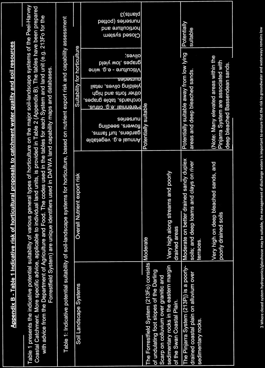
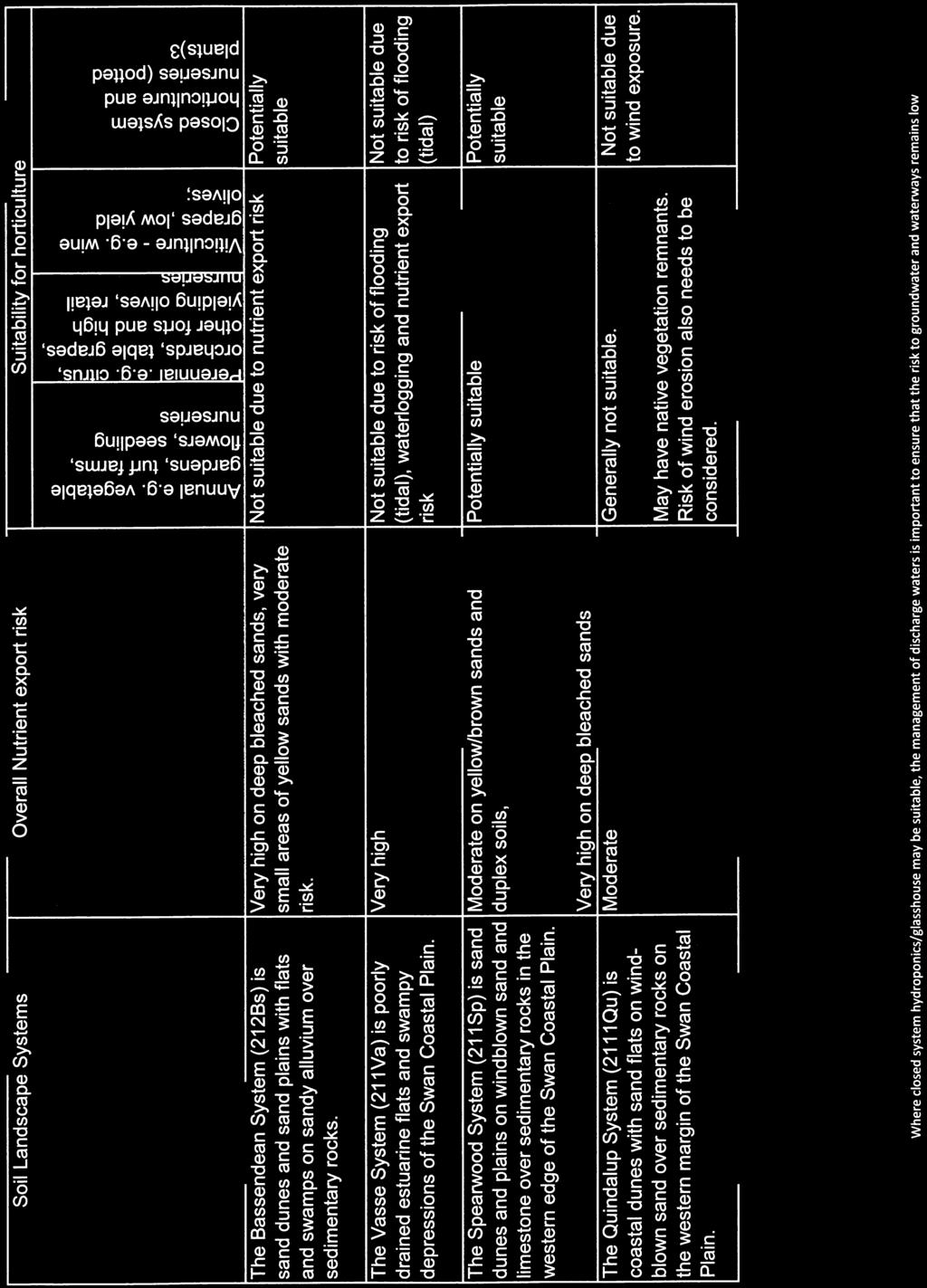
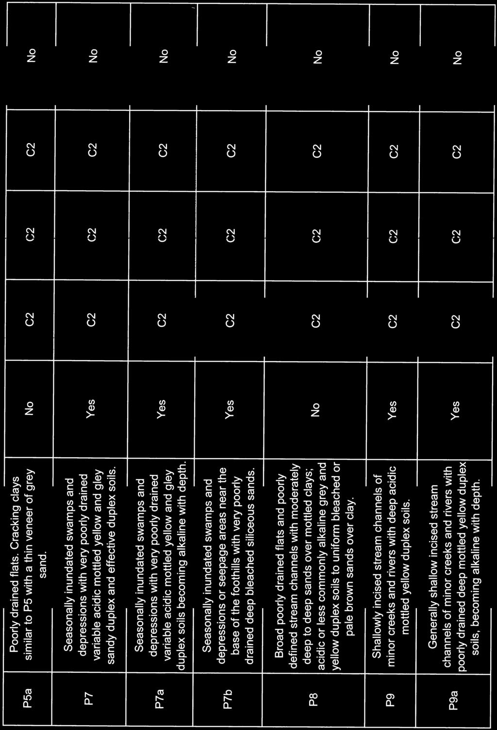
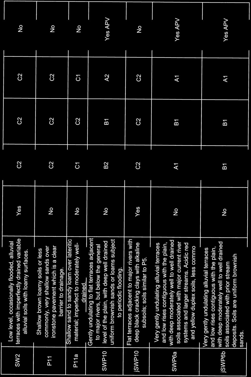
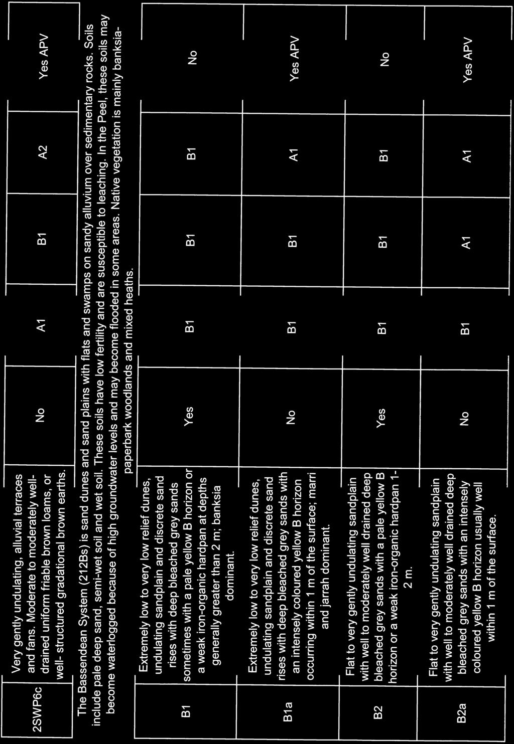
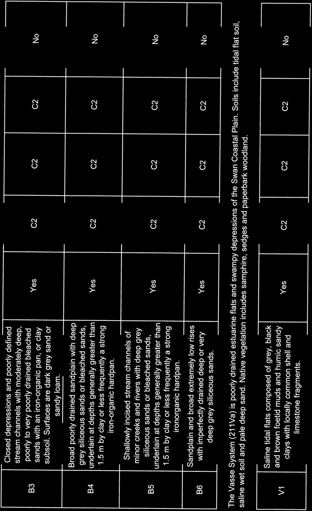
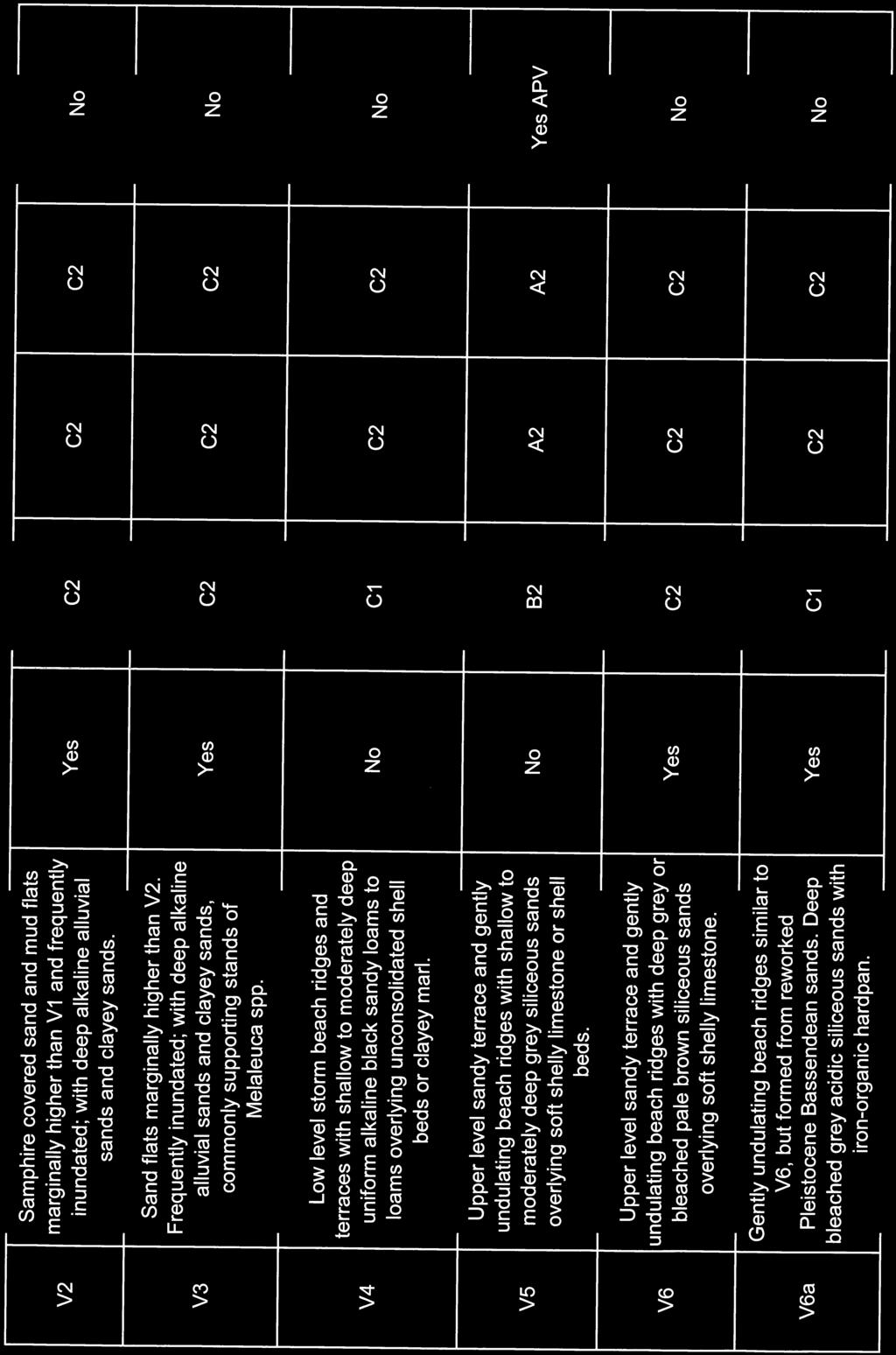
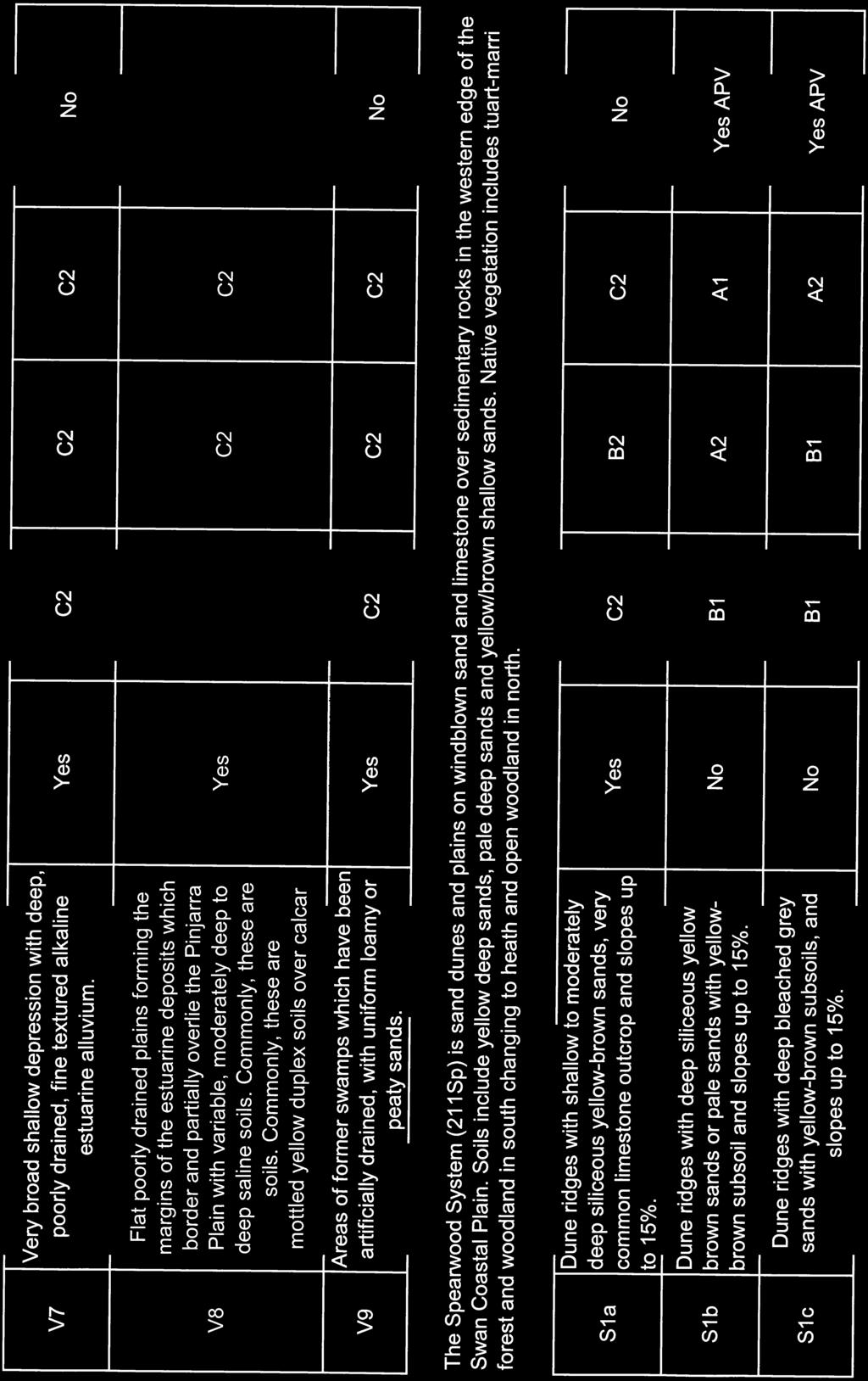
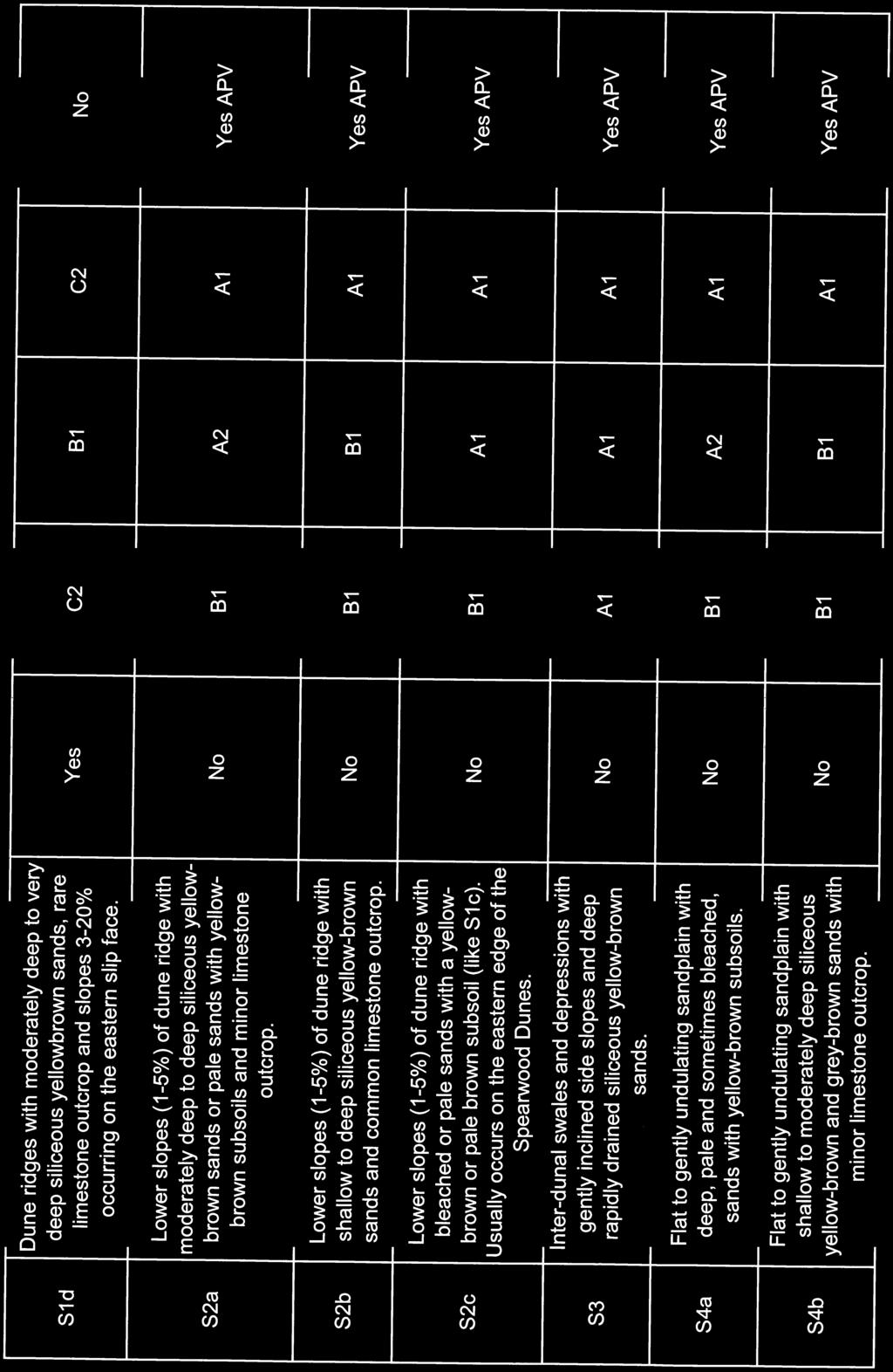
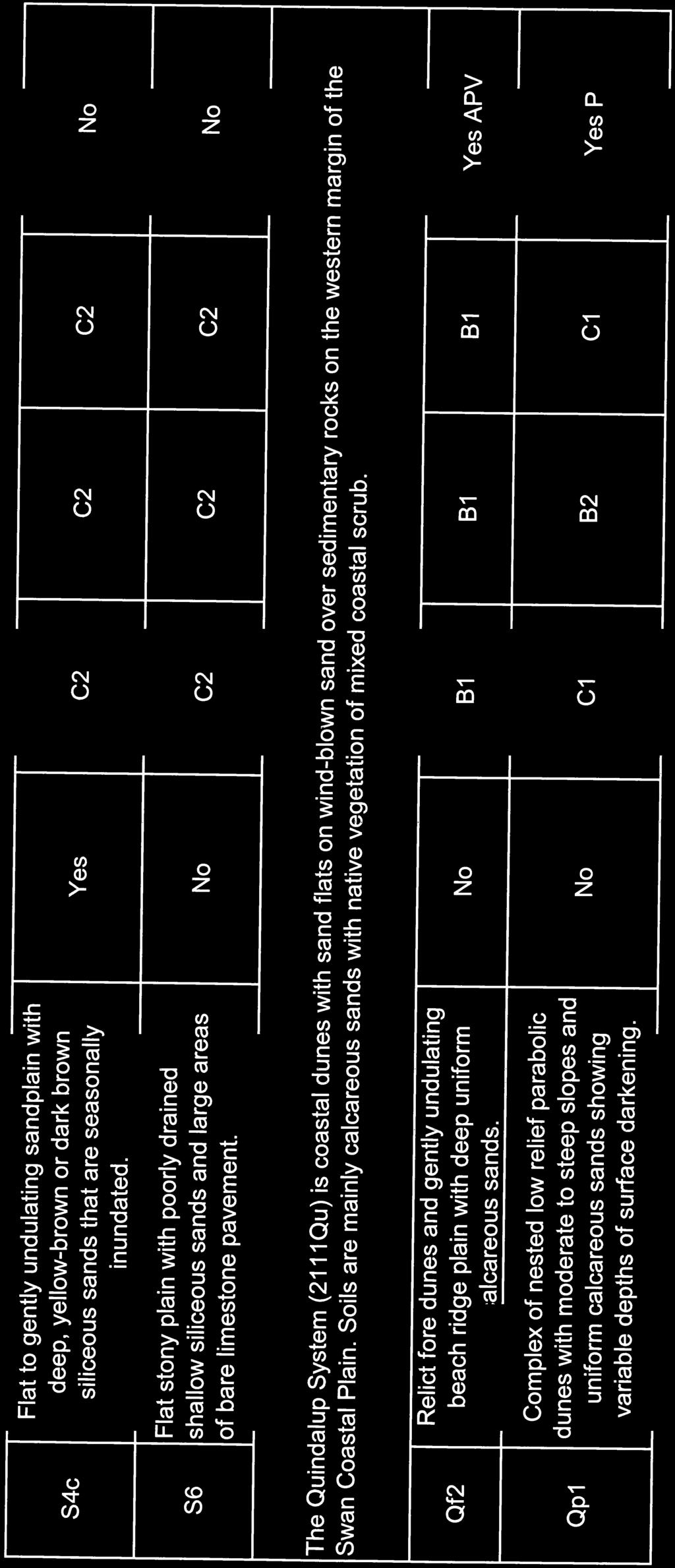
1 Local Planning Policy Horticultural Development within the Peel-Harvey Coastal Plain Catchment Introduction The expansion of in-ground horticulture in Peel-Harvey Coastal Catchment Area (Coastal Catchment Area) provides special environmental and planning challenges for the Catchment and Peel-Harvey Estuary. Some types of horticulture can significantly increase the loads of nutrients, mainly phosphorus and nitrogen, entering groundwater, watercourses, wetlands, and the Peel-Harvey Estuary. Once in the environment, nutrients reduce water quality, cause algal blooms, change conditions for aquatic fauna and can lead to fish kills. The Peel-Harvey Estuary is in a perilous state, and current levels of phosphorus entering the catchment s watercourses are double that which is estimated to return the estuarine system and lower rivers to a healthy state (EPA, 2008; Kelsey et al, 2011). Future horticultural development of the Coastal Catchment Area needs to be aligned more closely to the capability of each area s landforms and soils. As shown in Table 1, development of many of the Coastal Catchment soil-landscape systems for some types of horticulture poses a very high risk of nutrient export and water quality in Catchment rivers and the Peel Harvey Estuary. Table 1, Table 2 (Appendix B) and regional-scale soil-landscape unit mapping prepared by DAFWA provide important information on the potential suitability of a proposal with respect to its nutrient export risk and risk to catchment water quality. They are key information resources supporting the implementation of this Policy. Of all types of production, in-ground horticultural production systems (e.g. vegetable gardens, turf farms) pose the greatest risk to catchment water quality. This is due to the high amount of nutrients that horticultural crops require, the poor nutrient holding characteristics of many of the catchment s soils, high groundwater tables and the intensive drainage system on the Coastal Catchment Area. DRAFT A significant challenge is therefore to shift future production from in-ground systems to closed hydroponic systems, particularly for vegetable growing. Other solutions and technical advances to reduce nutrient export may also play a part for other production systems, but as yet have not been demonstrated to reduce nutrient export levels to those required to meet catchment water quality improvement targets. This policy provides guidance for best practice land management for horticulture to ensure further degradation of the Shire of Murray s waterways is minimised. Application of the Policy The policy applies to: All proposals for new horticulture within the Shire of Murray. This includes proposals in areas within the Peel-Harvey Coastal Plain Catchment as gazetted in State Planning Policy 2.1 and as shown in Figure 1; 1
2 Proposed changes/upgrades to horticultural operations where the proposed change/upgrade constitutes development under the Scheme or will likely result in increased nutrient export above which the development was originally approved; and All proposals that may compromise existing or potential future horticultural areas where relatively high capability soils are located. The policy does not apply to upgrades to an existing horticultural operation in relation to the irrigation, fertilisation or production system which would result in a reduction in nutrient application and/or export (and no other development is proposed as part of the upgrade). Applications will need to clearly demonstrate the proposal meets the objective and requirements of this policy. Applications must also meet any other requirement of the Shire s planning framework that may be applicable for a particular property under the Scheme, Structure Plan or Local Planning Policy. Policy Objectives The objectives of this policy are: To ensure new horticultural enterprises pose a low risk to catchment water quality and are able to meet or improve catchment standards for water quality improvement; To encourage new types of horticultural enterprises to the Policy Area which are compatible with Catchment Water Quality Improvement Standards; To encourage high-standards in horticultural management practices in all parts of the local government area; To ensure strategic and statutory proposals do not compromise existing well-managed horticultural developments, or compromise potential future horticultural development of relatively high capability areas. Interpretations Bushland Catchment Catchment Water Quality Catchment Water Quality Improvement Standards DRAFT Land on which there is vegetation which is either a remainder of the natural vegetation of the land, or, if altered, is still representative of the structure and floristics of the natural vegetation, and provides the necessary habitat for native fauna (EPA, 2008b). Is the area around the wetland or waterway that contributes surface runoff or groundwater to the wetland or waterway. The quality of water in ground and surface waters of the Peel-Harvey Coastal Catchment (Figure 1) including drains, creeks, wetlands, rivers and estuarine areas. Water quality parameters include levels of phosphorus, nitrogen, organics, salinity, acidity and total suspended solids. The threshold levels of nutrients applied to land, or exported from land, as set in Appendix A of this policy. 2
3 Closed system (as in closed system hydroponics) Coastal Catchment Area Horticulture or agriculture intensive Hydroponics In-ground horticulture Land capability Land suitability Nutrient Export Risk Assessment Peel-Harvey Coastal Catchment Production area Site Site Management Plan Soil-landscape systems of the Peel-Harvey Coastal Catchment Viticulture or vines Hydroponics system in which the nutrient solution is recirculated and the nutrient concentrations are monitored and adjusted accordingly. There is zero or minimal discharge of the solution or water to the environment. Same meaning as for Peel-Harvey Coastal Catchment Has the same meaning as agriculture intensive in the Model Scheme Text, that being premises used for trade or commercial purposes, including outbuildings and earthworks, associated with the following a.) the production of grapes, vegetables, flowers, exotic or native plants, or fruit or nuts; b.) the establishment and operation of plant or fruit nurseries; c.) the development of land for irrigated fodder production; d.) irrigated pasture (including turf farms); or e.) aquaculture. The process of growing plants using mineral nutrient solutions, without soil. Although hydroponic systems do not involve soil, they may involve a wide variety of growing media, such as perlite, gravel, peat, sand, rockwool and other. Horticulture where the crop is grown directly into in-situ soils and landforms, whether the soils have been amended or not. Land capability refers to the ability of land to support a type of land use without causing damage. Takes land capability information and other information (such as rainfall, environmental sensitivity) and looks at the overall suitability of a piece of land to accommodate a particular kind of development. It is useful for site selection and can also underpin the manner in which a particular type of development is carried out, so that the environmental limitations or constraints are fully recognised (EPA 2008b). An assessment of the nutrient export risk posed by a proposal on a specific site and production area. It should be carried out by a suitably qualified expert and able to be independently verified. See Section 9.2 of this local planning policy. DRAFT The catchment area defined in State Planning Policy 2.1 Peel-Harvey Coastal Plain Catchment. The area under crop production (excluding non-production areas on the Lot or Site) The lot or lots on which the production area is located. The plan prepared by the proponent to document how the production area and site will be managed over the lifespan of the operation to reduce nutrient export and manage all aspects of the operation in relation to the natural environment, pollution risk, visual landscape and maintenance of the amenity to neighbouring properties. A checklist to guide preparation of a Site Management Plan is included in Appendix E. Forrestfield System, Pinjarra System, Bassendean System, Vasse System, Spearwood System and Quindalup System The growing of grapes for wine; or growing of low yield olives. 3
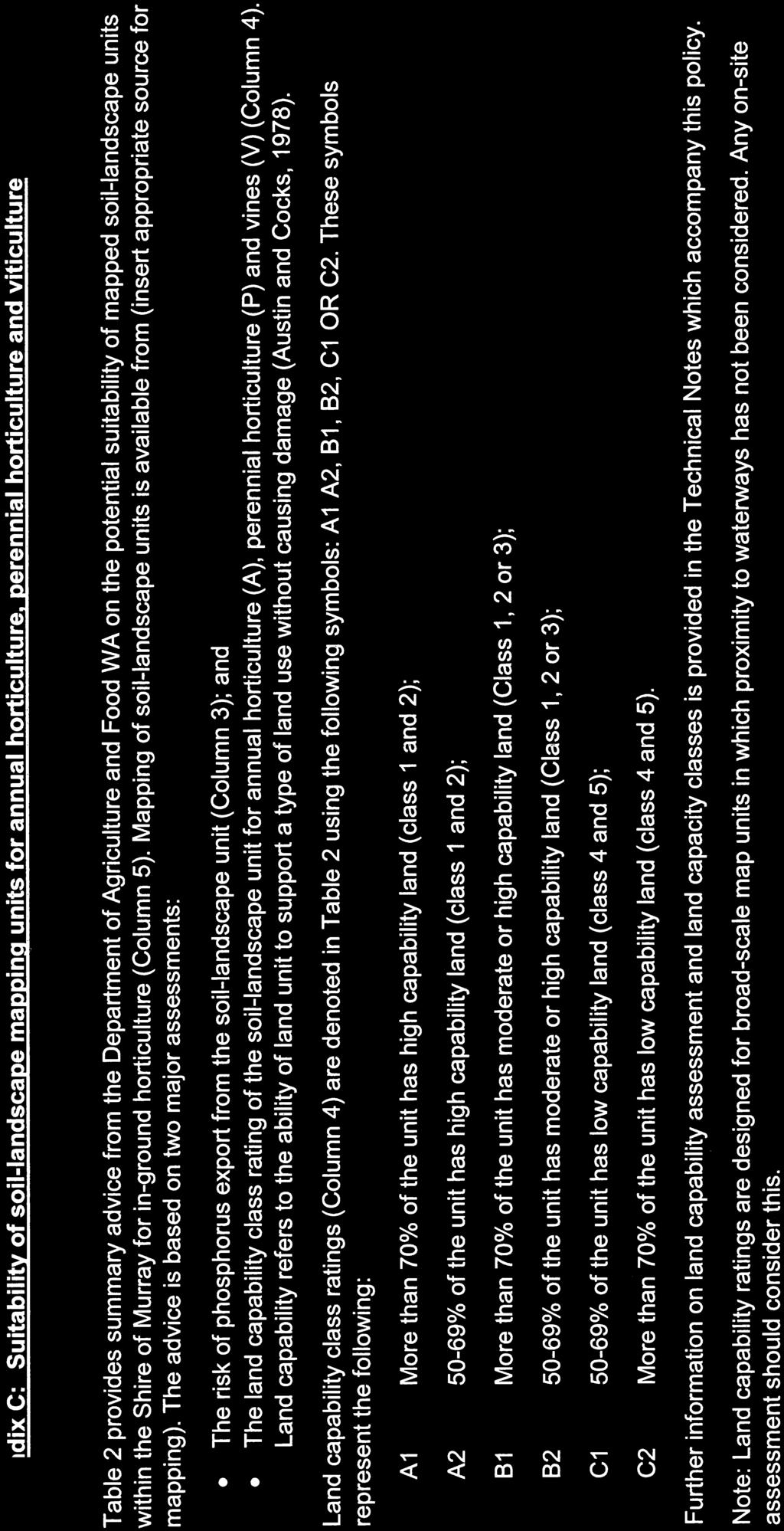
4 Watercourse Wetland A river, stream, creek or manmade drainage features in which water flows in a channel, whether permanently or intermittently (EPA, 2008b). Areas of seasonally, intermittently or permanently waterlogged soils or inundated land, whether natural or artificial, fresh or saline (EPA, 2008b) Planning Approval Requirements In determining or providing advice on strategic or statutory horticultural planning proposals, the following provisions shall apply: 1. Proponents should be encouraged to move towards closed production systems, such as closed hydroponics, where such systems are available for particular crops. 2. Proposals for horticulture should pose a low risk to Catchment Water Quality, the environment and land resources and aim to achieve the Catchment Water Quality Improvement Standards as set out in Appendix A. 3. All proposals for horticulture should be accompanied by a Site Management Plan. Guidance on preparation of a Site Management Plan is included in Appendix D. 4 All proposals for nurseries (potted plants) and closed systems (e.g. closed system hydroponics) should be accompanied by a Site Management Plan sufficiently detailed to ensure that the proposal will pose a low risk to catchment water quality and other environmental values and be well managed. 5 All proposals for annual and perennial horticulture and viticulture in the Coastal Catchment Area which are located on Soil-landscape mapping units which are not potentially suitable for the proposed type of horticulture (Appendix B) should be accompanied by a Site Management Plan which reduces nutrient export risks to achieve Catchment Water Quality Improvement Standards, and includes: a. Site-specific soil testing b. Site-specific land capability assessment c. Nutrient Export Risk Assessment. d. All other details listed in Appendix D, including measures to reduce risk of nutrient export. DRAFT 6 Outside of the Coastal Catchment Area, where a risk is posed to Catchment Water Quality or other environmental values, the local government may on the advice of the Department of Agriculture and Food WA or other relevant state agencies, require proponents to provide site specific soil testing and land capacity assessment and a Nutrient Export Risk Assessment as part of the Site Management Plan. 7 Unless otherwise demonstrated through site specific studies as described in Clause 8, the Shire of Murray shall consider a proposal likely to pose a significant risk to catchment water quality and likely to be substantially at variance with the objectives and provisions of SPP2.1 and the Peel-Harvey Environmental Protection Policy where the site s soil-landscape unit(s) is not potentially suitable for the proposed annual or perennial horticulture or viticulture as denoted in Table 2, Column 5 (Appendix B). 8 Where on-site soil-landscape conditions vary from the mapped land units shown in Regional-scale soil-landscape unit mapping prepared by DAFWA, then this may be demonstrated through site-specific soil testing and site-specific land capability assessment for the proposed type of horticultural land use. This site-specific testing 4
5 and assessment shall be included in the Site Management Plan, carried out by an appropriately qualified expert and supported by Department of Agriculture and Food WA. The standards of soil testing and land capability assessment should be generally in accordance with Appendix C, or as otherwise advised by DAFWA. 9 Based on all available evidence, proposals which pose a significant risk to catchment water quality and are very likely to be substantially at variance with the objectives and provisions of SPP2.1 and the Peel-Harvey Environmental Protection Plan should be refused, even in a modified form, with reasons given. Available evidence includes Table 2, Site Management Plan including site specific soil testing and land capability assessment and the advice of DAFWA and other relevant agencies. 10 Due regard shall be given to the Other Considerations listed in Appendix D and any other relevant matters, when assessing all proposals for horticulture. 11 Consideration shall be given to the advice of the relevant government departments, including the Department of Agriculture and Food and Department of Water, when making determinations or providing advice or recommendations on horticultural proposals. For example, such advice may include the: a. Adequacy of soil testing regimes; b. Review of results and analysis of soil testing and other site testing; c. Likely implications of the proposal on Catchment Water Quality; d. The level of risk posed by the proposal to Catchment Water Quality; and e. Assessment of groundwater availability to the site. 12 When determining proposals, the local government may give consideration to imposing conditions, among others, so as to minimise the ongoing risk that the development may pose to catchment water quality, such as: a. Placing a finite time limit on the Development Approval; b. Conditioning the ongoing operation of the development on the results of surface and groundwater monitoring. c. Conditioning the ongoing operation of the development on the implementation of contingency measures, as triggered by the results of surface and groundwater monitoring. DRAFT 13 Where an approval or conditional approval is issued, Council should advise the proponent that a further separate approval is required for any proposed changes to the operation of the horticultural development that would increase the risk of nutrient export (from that which was approved). All proposals 14 All strategic and statutory proposals should give due regard to the impact on existing horticultural enterprises, and should aim to protect potential future horticultural areas with relatively high capability soils. 15 Following a review of any relevant technical information or advice provided by a State government agency, where a proposal is likely to compromise the buffer requirements of an established horticultural operation then there should be a presumption against approval of the proposal unless the proponent can satisfactorily demonstrate that the proposal is compatible with the horticultural operation. 5
6 16 Due regard shall be given to accepted buffer requirements set by government, including: i. Guidelines for Separation of Agricultural and Residential Land Uses (Department of Health, 2012); ii. Protection of buffer areas as set out in the Peel Region Scheme Strategic Agricultural Resource Policy. 17 In accordance with State Planning Policy 2.5 Land Use Planning in Rural Areas (as amended), where a proposal is likely to compromise the future potential development of rural zoned lands having soils of a relatively high capability for horticultural use, then the local government should aim to protect the potential future use of the land for horticulture or other productive agriculture. Other issues to consider 18 Protection of groundwater and surface waters Potential impacts of dam or drain construction (note: Approvals are generally required for dams and drain construction); Storage of hydrocarbons, pesticides and other chemical; Levels of total suspended solids and organics in discharge waters (e.g. hydroponics) or drains/watercourses on the site; Levels of salinity and acidity of discharge waters (e.g. hydroponics). 19 Stormwater Management Management of runoff from hard surfaces and production area and site 20 Wetlands Proposals should comply with State Government policy in regard to: - protection and management of Conservation Category Wetlands; - protection and management of Resource Enhancement Wetlands, and - management of Multiple Use Wetlands (Water and Rivers Commission, 2001) (EPA, 2008b) 21 Wetland Buffers DRAFT Wetland buffers should be determined in accordance with the Draft Guideline for the Determination of Wetland Buffer Requirements (WAPC, 2005). 22 Watercourse protection Identification of suitable buffers to watercourses; Physical delineation and protection of the buffer area; Restoration of vegetated buffers. 6
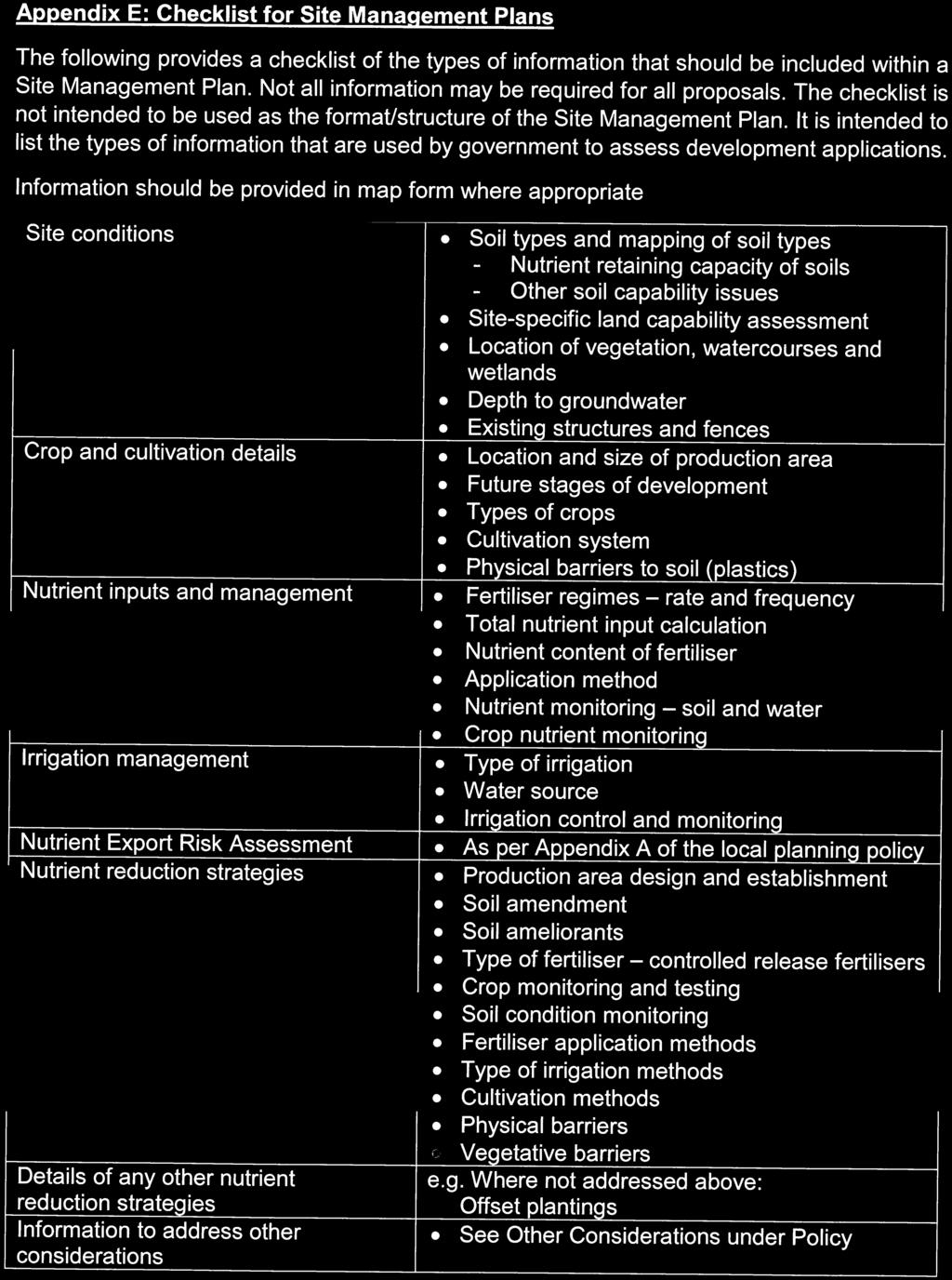
7 23 Native vegetation and bushland protection Protection of: - Peel Regionally Significant Natural Areas; - Known location of Declared Rare and listed species of flora and fauna; - Threatened Ecological Communities; - Priority Ecological Communities; - Other significant vegetation and flora; - Other habitat for wildlife; - Buffers to native vegetation and bushland protection. 24 Weeds, pests and diseases Compliance with control and management of species listed under the Biosecurity and Agricultural Management Act and Regulations; Other weed management; Other feral animal management. 25 Odours/Noise Storage and use of manures. Operating hours; Types and standards of machinery or motors. 26 Visual amenity Existing vegetation; Proposed revegetation and landscaping. 28 Management of effluent Workers ablution facilities; Effluent treatment systems with nutrient retentive capability. 29 Transport Impact Assessment Consider road access standard and property access standards to local roads. Supporting Documentation This policy is supported by: Appendix A DRAFT Peel Harvey Catchment Water Quality Improvement Standards and guidance Appendix B Appendix C Appendix D Appendix E Table 1 - Indicative risk of horticultural proposals to catchment water quality and soil resources Table 2 - Suitability of soil-landscape mapping units for annual horticulture, perennial horticulture and viticulture Guidance on site specific soil testing and land capability assessment for horticulture on the Peel Harvey coastal plan catchment. Check list for Site Management Plans 7
8 Administration Directorate Officer Title Planning and Sustainability Director Planning and Sustainability Version Decision to Advertise Decision to Adopt/Amend Current Status 1 OCM16/ April 2016 OCMxxx/xxx xxx Draft DRAFT 8
9
10

11

12
13
14
15
16

17
18
19
20
21
22
23
24
25
26
27
28
dairyshed effluent Western Australia Code of Practice for DAIRY Western Funded by Dairy Australia and your dairy service levy
 Code of Practice for dairyshed effluent Western Australia Funded by Dairy Australia and your dairy service levy Western DAIRY BACKGROUND The Western Australian dairy industry recognises the importance
SECTION 3: Water, Wetlands and Waterways
 SECTION 3: Water, Wetlands and Waterways KEY PRIORITY To ensure protection of water quality and quantity for use by residents, the commercial sector and ecosystems, through integrated consultation, planning,
Appendix E : Guidelines for Riparian Buffer Areas
 Appendix E : Guidelines for Riparian Buffer Areas This document should be read in conjunction with the CRCA Planning Policy. 1.0 PURPOSE The purpose of this document is to summarize the recommendations
Watercourses and Wetlands and Agricultural Activities
 Watercourses and Wetlands and Agricultural Activities Watercourses and regulated wetlands can be found throughout New Brunswick, including on agricultural lands. The Clean Water Act defines a watercourse
SABI Code of Practice for On-farm Irrigation Design
 SABI Code of Practice for On-farm Irrigation Design This code was developed to provide guidelines for irrigators and those servicing irrigators on developing a new irrigation system or upgrading an existing
Greening Agriculture Policies and Laws
 Greening Agriculture Policies and Laws What? Greening agricultural business is introducing environmental measures to result in sustainable economic benefits - reducing overconsumption (losses pollution,.
subdivision BUSH LIVING ENVIRONMENT ASSESSMENT CRITERIA RULES
 RULES 10.0 General The following rules apply to Subdivision of land within the Bush Living Environment except that area identified as Titirangi Subdivision Area 1 and Titirangi-Laingholm Subdivision Area
Interim: Developing a local water management strategy
 Interim: Developing a local water management strategy Department of Water December 2008 Department of Water 168 St Georges Terrace Perth Western Australia 6000 Telephone +61 8 6364 7600 Facsimile +61 8
(No. of pages excluding this page = 10)
") SPECIALIST CONSULTANT STUDIES 3-65 BIG ISLAND MINING PTY LTD (No. of pages excluding this page = 10) Ltd BIG ISLAND MINING PTY LTD 3-66 SPECIALIST CONSULTANT STUDIES This page has intentionally been left
SPECIALIST CONSULTANT STUDIES 3-65 BIG ISLAND MINING PTY LTD (No. of pages excluding this page = 10) Ltd BIG ISLAND MINING PTY LTD 3-66 SPECIALIST CONSULTANT STUDIES This page has intentionally been left
Research and discuss water catchments to help you answer the following questions.
 Catchments Clean water is vital to healthy communities, agriculture and economies. We need clean water upstream to have healthy communities downstream, and the health of rivers, lakes, bays, and coastal
POLICY FOR NATURAL RESOURCE MANAGEMENT AREAS
 POLICY FOR NATURAL RESOURCE MANAGEMENT AREAS I. POLICY STATEMENT Auburn University's (the University's) "Policy for Natural Resource Management Areas" implements the Campus Master Plan Land Use Element
3 Objectives 3 Ob jec tives
 3 Objectives 3 Objectives 3 Objectives 3 Objectives contents Objective number Page 3.1 Ki uta ki tai: mountains to the sea O1-O5 37 3.2 Beneficial use and development O6-O13 38 3.3 Māori relationships
Wetland Design Manual. Supporting document: Planning, funding and. management
 Wetland Design Manual Supporting document: Planning, funding and management Contents Introduction... 2 Water Industry Act (1994)... 2 Water Act (1989)... 3 Planning and Environment Act (1987)... 3 Subdivisions
Overview and key environmental issues
 Blue Mountains Draft Local Environmental Plan 2013 1 Information Sheet 4 Overview and key environmental issues Use this document in conjunction with Information Sheet 5: SUBMISSION WRITING GUIDE AND SUMMARY
Woady Yaloak Catchment Group
 Woady Yaloak Catchment Group Five year direction plan (2003-2007) February 2003 (Draft Version 1) About the catchment The Woady Yaloak Catchment covers an area of 115,000 ha and is located south west
phosphorus in catchments
 Managing 11 phosphorus in catchments Phosphorus is an essential component of all plants and animals, and is a natural part of the rocks that comprise the earth s crust. While phosphorus is a natural and
Morton West, Dacland. Hydrology / Stormwater Management Report Permit Application
 Morton West, Dacland Hydrology / Stormwater Management Report Permit Application February 2014 Document history Revision: Revision no. Author/s R01 Jonathon McLean Approved Jonathon McLean Distribution:
Section 1 - Introduction
 VERSION 1.0 Stormwater Solutions for Residential Sites Section 1 - Introduction Prepared for EcoWater Solutions A Department of Waitakere City Council 113 Central Park Drive Henderson WAITAKERE CITY November
GREATER DANDENONG PLANNING SCHEME AMENDMENT C201
 Planning and Environment Act 1987 GREATER DANDENONG PLANNING SCHEME AMENDMENT C201 Who is the planning authority? EXPLANATORY REPORT This amendment has been prepared by the City of Greater Dandenong who
INTRODUCTION TO HOBBY FARMING AND WATER QUALITY
 SECTION ONE INTRODUCTION TO HOBBY FARMING AND WATER QUALITY This is a handbook for owners of Hobby Farms - small scale farms operated primarily as a residential lifestyle - to provide their owners with
Technical Specification for Natural Area Management and Environmental Consulting Services Preferred Supplier Panel
 Technical Specification for Natural Area Management and Environmental Consulting Services Preferred Supplier Panel Prepared for the Western Australian Local Government Association by Nam Natura Consulting
8.1 ENVIRONMENTAL CONSTRAINTS / LAND CAPABILITY MAP OF THE OXFORD FALLS LOCALITY
 5874\168 PAGE 168 ENVIRONMENTAL CONSTRAINTS / LAND CAPABILITY MAP OF THE OXFORD FALLS LOCALITY Reporting Officer General Manager Purpose To report to Council on the strategic land capability assessment
E2. Water quantity, allocation and use
 E2. Water quantity, allocation and use E2.1. Introduction E2 Water quantity, allocation and use Demand for water already equals or exceeds availability in some surface waterbodies and aquifers. Future
D9. Significant Ecological Areas Overlay
 D9. Significant Ecological Areas Overlay D9.1. Background Auckland's indigenous biodiversity is unique with a diverse range of ecosystems reflecting the complex physical environment of the region. Natural
Ipswich City Council PLANNING SCHEME FACT SHEET NO. 4
 Ipswich City Council PLANNING SCHEME FACT SHEET NO. 4 Vegetation Management 1. Introduction This Fact Sheet is one of a series which deals with planning scheme related information. This Fact Sheet deals
o n e c i t y d i v e r s e p l a c e s
 City of Swan our Swan 2030 discussion paper our natural environment o n e c i t y d i v e r s e p l a c e s 2 our Swan 2030 our natural environment Contents 1. Background 4 2. Trends 4 3. Key Considerations:
1 General questions on zone and catchment management plans
 1 General questions on zone and catchment management plans 1.1 What is a zone plan? The Waikato region is divided into eight zones. There is a separate, non statutory, zone plan for each one. The key purpose
Role of Soils in Water Quality. Mike Marshall Extension Associate Texas A&M-Institute of Renewable Natural Resources
 Role of Soils in Water Quality Mike Marshall Extension Associate Texas A&M-Institute of Renewable Natural Resources Water Quality in Texas Water is a finite resource that can be impaired by pollution from
WESTERN DIVISION POLICY
 WESTERN DIVISION POLICY Preamble 5 10 15 20 The Nature Conservation Council of NSW has had a long history of involvement in issues relating to land management in the Western Division of NSW. In the period
Appendix X: Non-Point Source Pollution
 Appendix X: Non-Point Source Pollution Sources Nonpoint source of pollution, unlike pollution from industrial and sewage treatment plants, comes from many different sources. Nonpoint source pollution is
Center for Nutrient Solutions (CNS) Nutrient Solution Scenarios Concept Paper September 5, 2014 Draft
 Nutrient Solution Scenarios Concept Paper September 5, 2014 Draft") I. Introduction Center for Nutrient Solutions (CNS) Nutrient Solution Scenarios Concept Paper September 5, 2014 Draft A key goal of the CNS is to develop and test tools for evaluating tactics and strategies
I. Introduction Center for Nutrient Solutions (CNS) Nutrient Solution Scenarios Concept Paper September 5, 2014 Draft A key goal of the CNS is to develop and test tools for evaluating tactics and strategies
Rural Residential Development Control Plan
 1 Rural Residential Development Control Plan Council of the City of Greater Lithgow 180 Mort Street, Lithgow NSW 2790 Telephone: (02) 6354 1077 2 EXPLANATORY NOTE: Council has been aware for some time
Very slight to negligible limitations no special land management practices required.
 Land Capability Classes Land and Soil Capability Class 1 Class 1 Definition Very slight to negligible limitations no special land management practices required. On-site impact of land management practices
Sustainable river management in the Queensland Murray Darling Basin
 Sustainable river management in the Queensland Murray Darling Basin Nicole Gammie a, Kate Steel b and Ken Baker c a Queensland Murray Darling Committee, PO Box 6243, Toowoomba, (E-mail: n.gammie@landcare.org.au)
Issues in measuring and managing changes to the ecological character of the Western Port Ramsar Site as a result of climate change
 presenter: Shelley Heron Issues in measuring and managing changes to the ecological character of the Western Port Ramsar Site as a result of climate change Western Port Bay Where is it? Ecological character
Submission to the Murray Darling Basin Authority (Proposed Basin Plan)
") Submission to the Murray Darling Basin Authority (Proposed Basin Plan) April 2012 Tim Whetstone MP, Member for Chaffey 13 Kay Ave Berri SA 5343 Introduction I support a Basin Plan that delivers a balanced
Submission to the Murray Darling Basin Authority (Proposed Basin Plan) April 2012 Tim Whetstone MP, Member for Chaffey 13 Kay Ave Berri SA 5343 Introduction I support a Basin Plan that delivers a balanced
Fact Sheet. Chesapeake Bay Water Quality
 Fact Sheet Chesapeake Bay Water Quality Water quality is a critical measure of the Chesapeake Bay s health. For the Bay to be healthy and productive, the water must be safe for people and must support
Objective NAT-1.1. Maintain the best possible air quality, meeting or exceeding state and federal air quality standards.
 Vision Statement: Maintain and enhance the natural environment in the City of Coral Gables and surrounding areas through the promotion of environmental protection and sustainability. Goals, Objectives
WATERSHED. Maitland Valley. Report Card 201
 Maitland Valley WATERSHED Report Card 201 The Maitland Valley Conservation Authority has prepared this report card as a summary on the state of our forests, wetlands, surface water, and ground water resources.
GLASI GLASI. Priority Subwatershed Project. Great Lakes Agricultural Stewardship Initiative
 GLASI GLASI Great Lakes Agricultural Stewardship Initiative Priority Subwatershed Project Wigle Creek Priority Subwatershed Project Essex Region Conservation Authority Up to $75,000 per eligible farm business
Applying the rural zones
 Applying the rural zones VPP practice note March 2007 The purpose of this Practice Note is to provide guidance to planning authorities about: the strategic work required to apply the Farming Zone, Rural
Chapter 10 Natural Environment
 Chapter 10 Natural Environment Existing Conditions The Natural Environment Element addresses the protection, conservation, preservation, and restoration of the natural resources the Bayview Ridge Subarea,
4. Ponds and infiltration BMPs can achieve 60 to 100% removal efficiencies for sediment.
 Landscape BMPs For the purposes of this project, preventive measures have been categorized into two categories: landscape BMPs and source prevention BMPs. Landscape BMPs includes both vegetative practices
13 Land Use Activities and Indigenous Biological Diversity
 13 Land Use Activities and Indigenous Biological Diversity 13.1 Land Use Activities 13.1.1 Objectives Objective 13-1: Accelerated erosion* - regulation of vegetation clearance*, land disturbance*, forestry*
The Purpose and Scope of this Guidance
 Introduction The nation s aquatic resources are among its most valuable assets. While environmental protection programs in the United States have successfully improved water quality during the past 25
CON 509: APPLICATION FOR A RESOURCE CONSENT UNDER THE RESOURCE MANAGEMENT ACT 1991
 APPLICATION TO USE LAND FOR FARMING ACTIVITY PAGE 1 OF 15 August 2016 CON 509: APPLICATION FOR A RESOURCE CONSENT UNDER THE RESOURCE MANAGEMENT ACT 1991 TO USE LAND FOR A FARMING ACTIVITY WITHIN THE SELWYN
Rural industries code
 9.3.15 Rural industries code 9.3.15.1 Application (1) This code applies to accepted development and assessable development identified as requiring assessment against the Rural industries code by the tables
Biodiversity certification and banking in coastal and growth areas
 Biodiversity certification and banking in coastal and growth areas 1 Biodiversity certification and banking in coastal and growth areas This paper sets out the broad parameters of the new direction and
Funding Guidelines State Fiscal Year 2016
 State Fiscal Year 2016 Water Quality Financial Assistance Centennial Clean Water Program Clean Water Act Section 319 Program Stormwater Financial Assistance Program Washington State Water Pollution Control
ROUNDTABLE MEETING ON SUSTAINABLE PALM OIL. RSPO Guidance for the Management and rehabilitation of Riparian Reserves Holly Barclay
 ROUNDTABLE MEETING ON SUSTAINABLE PALM OIL RSPO Guidance for the Management and rehabilitation of Riparian Reserves Holly Barclay Riparian reserves (also called riparian buffer zones ) = strips of natural
Waterways Local Update
 Waterways Local Update 2016-17 Melbourne Water s work to improve waterways and provide flood protection in the City of Moonee Valley. 7.9 km REVEGETATION ALONG WATERWAYS SUPPORTED WATER SENSITIVE URBAN
Agriculture and farm related businesses and industries are important economic generators for the local and regional community.
 SECTION 3: LAND USE POLICIES - AGRICULTURE Lands designated Agriculture are areas with highly valued soils in accordance with the CLI mapping and therefore have potential for agricultural production, areas
State Planning Policy 4/2010 Healthy Waters
 Prepared By: Water Quality and Accounting Department of Environment and Resource Management State of Queensland (Department of Environment and Resource Management) 2010 This document has been prepared
MPT.2.8. Management Plan Technique. Index. Description and Explanations
 MPT.1 Management Plan Technique Index MPT.1 Management Plan Technique MPT.1.1 MPT.1.2 MPT.1.3 MPT.1.4.1.2.3.4.5.6.7.8 Description and Expectations Eligibility Rule Objectives Explanation Description and
Environmental Program
 Environmental Program FLORA AND FAUNA MANAGEMENT BBA-ENP-1000-1400-0011 Revision Date Revision Description Prepared Reviewed Approved A0 30 April 2007 Draft for BBA review SW A1 9 May 2007 Draft for review
B7. Toitū te whenua, toitū te taiao Natural resources
 B7. Toitū te whenua, toitū te taiao Natural resources Ngā ariki o te rangi, ngā ariki o te whenua, ngā ariki o te moana, ngā ariki o te taiao The chiefly deities of the sky, of the earth, of the sea, the
Lake Mealup on the road to recovery: an adaptive management approach to acid suphate soils. Department of Parks and Wildlife Western Australian
 Lake Mealup on the road to recovery: an adaptive management approach to acid suphate soils Department of Parks and Wildlife Western Australian Lake Mealup 90 ha freshwater wetland part of the Peel Yalgorup
Hazardous Substances. 9. Hazardous Substances. Explanatory Statement
 Hazardous Substances 9. Hazardous Substances Explanatory Statement The Western Bay of Plenty District is predominantly rural land in farming and horticulture and has a number of small urban centres containing
Summary of relief sought by Dairy Holdings Limited
 Summary of relief sought by Dairy Holdings Limited Evidence or legal submission paragraph reference Issue (including objective/policy /rule reference) Explanation Relief sought by DHL [5] [15] Definition
SCHEDULE 4 TO CLAUSE THE SPECIAL USE ZONE. Shown on the planning scheme map as SUZ4. GOULBURN VALLEY HARNESS AND GREYHOUND RACING PRECINCT
 --/--/--- Proposed C199 SCHEDULE 4 TO CLAUSE 37.01 THE SPECIAL USE ZONE Shown on the planning scheme map as SUZ4. GOULBURN VALLEY HARNESS AND GREYHOUND RACING PRECINCT Purpose General To facilitate use,
Waterways Local Update
 Waterways Local Update 2016-17 Melbourne Water s work to improve waterways and provide flood protection in the City of Banyule. REDUCED THE RISK OF FLOODING 29.7 km WEED CONTROL ALONG WATERWAYS THREE ENVIRONMENTAL
PLANNING ASSESSMENT SHEET: FARMING ACTIVITY IN HINDS/HEKEAO CATCHMENT
 APPLICATION TO USE LAND FOR FARMING ACTIVITY IN HINDS/HEKEAO CATCHMENT PAGE 1 OF 11 MAY 2017 PLANNING ASSEMENT SHEET PREPARED FOR FARMING ACTIVTIES WITHIN HINDS/HEKEAO CATCHMENT The Resource Management
Rural Land Program. A guide to reducing the impact of runoff to waterways
 Rural Land Program A guide to reducing the impact of runoff to waterways We are all land stewards Whether we earn an income from agriculture or just enjoy living in a rural area, it is important that our
Why the Plan is more appropriate than relying on voluntary actions
 7.25 Parrots feather (Myriophyllum aquaticum) Why is it a threat? Parrots feather is a stout hairless perennial semi-aquatic plant that originates from South America. It was introduced to New Zealand as
Catchment Water Quality Protection
 Catchment Water Quality Protection Policy and Guidelines for Planning Permit Applications & Government Planning Initiatives Final31 Oct 2013 Policy Coliban Water s vision is to contribute to improving
Urban Development Institute of Australia Western Australian Division Incorporated
 Our Ref: 22.20 29 th April 2005 Swan River Trust PO Box 6740 Hay St, East Perth WA 6892 Attn: Darryl Miller Dear Sir, Draft Swan and Canning Rivers Management Bill 2005 The Urban Development Institute
Southland Water and Land Plan Environment Southland Private Bag Invercargill 9840
 To: From: Southland Water and Land Plan Environment Southland Private Bag 90116 Invercargill 9840 policy@es.govt.nz Mid-Aparima Catchment Group C/O Jolene and Hadleigh Germann (jolene@agribusiness.co.nz)
Understanding Agriculture And Clean Water
 1 IOWA CHAPTER Understanding Agriculture And Clean Water Clean Water Act Established in 1972, the Clean Water Act (CWA) created the basic structure for regulating discharges of pollutants into water bodies
WHAT THE YARRA RIVERKEEPER ASSOCIATION THINKS ABOUT THE ISSUES FACING OUR RIVER
 Working together to protect & enjoy the Yarra WHAT THE YARRA RIVERKEEPER ASSOCIATION THINKS ABOUT THE ISSUES FACING OUR RIVER The Yarra Riverkeeper Association is a not-for-profit community organisation
Commencement Date. This section applies to all land under Newcastle Local Environmental Plan 2012.
 5.03 Tree Management Amendment history Version Number Date Adopted by Council Commencement Date 1 15/11/2011 15/06/2012 New Amendment Details Savings provisions Any development application lodged but not
Water for life and livelihoods
 Water for life and livelihoods Dee River Basin District: Challenges and choices Facts and statistics Background information On 1 April Natural Resources Wales brought together the work of the Countryside
Current Research on North Adelaide Plains. Dr Kathy Ophel Keller Research Chief, Sustainable Systems SARDI
 Current Research on North Adelaide Plains Dr Kathy Ophel Keller Research Chief, Sustainable Systems SARDI SARDI s Research Divisions SARDI Aquatic Sciences Sustainable management strategies for wild fisheries
NRCS Programs and Practices for Riparian Areas in Hawaii
 NRCS Programs and Practices for Riparian Areas in Hawaii NRCS Pacific Islands Area Hawaii - State (State (PIA) Office Honolulu, Oahu) Seven field offices (Kauai, Oahu, Molokai, Maui, Hawaii) Plant Materials
B.1.5 Sodic and acidic soils
 B.1.5 Sodic and acidic soils Alice Thompson * Sodicity The effects of soil salinity have been well publicised, with dramatic images of bare and badly gullied land glistening with salt crystals, and of
Section Three, Part 2 Protection of the Urban Environment
 PART 2 PROTECTION OF THE URBAN ENVIRONMENT LANDFORMS, VEGETATION, AIR AND AMENITY 2.1 INTRODUCTION This part of the District Plan outlines how the environment and resources of the urban parts of the District
Critical Areas Ordinance
 Public Review Draft //7 Public Review Draft //7 4 5 6 Kitsap County Code Title 9 Critical Areas Ordinance 7 8 9 0 Underline / Strike out Version 9.800 Appendices 4 5 6 7 8 9 0 4 5 Public Review Draft //7
Melbourne Water drainage explanatory brief, Minta Farm PSP
 5 th April 2018 Melbourne Water drainage explanatory brief, Minta Farm PSP 1. Melbourne Water is the Waterway, Floodplain and Regional Drainage Management Authority for the Port Phillip and Western Port
Network utilities, subject to compliance with Part 6 (Infrastructure) A.3 Existing vegetation cover.
 A.3 Existing vegetation cover.") 5.3.2. Rural Zone 5.3.2.1. Permitted Activities 5.3.2.1.1. Residential, recreational, agricultural, exotic forestry or tourist related activities which comply with the standards for permitted activities
5.3.2. Rural Zone 5.3.2.1. Permitted Activities 5.3.2.1.1. Residential, recreational, agricultural, exotic forestry or tourist related activities which comply with the standards for permitted activities
It is essential for the future wealth and wellbeing of the Region that this trend does not continue to diminish this finite resource.
 Auckland Regional Council Soil Conservation: 12 1 12.1 Introduction Soil resources have made an important contribution to the growth, prosperity and diversity of the Auckland Region. The Region s variety
State Environmental Planning Policy No 62 Sustainable Aquaculture
 Page 1 of 16 State Environmental Planning Policy No 62 Sustainable Aquaculture [2000-473] Status Information Currency of version Current version for 23 February 2011 to date (accessed 6 February 2012 at
Maitland Valley WATERSHED
 Maitland Valley WATERSHED Report Card 2018 Maitland Conservation has prepared this report card as a summary of the state of your forests, wetlands, and water resources. WHERE ARE WE? We are one of 36 Conservation
Agriculture A GRICULTURE
 Agriculture Throughout Europe, the intensification and specialisation of agricultural production have resulted in considerable environmental pressures. Among the most important consequences are soil erosion,
Issues Paper. Planning requirements for the establishment of large packing sheds in rural areas on agricultural land
 The united voice of intensive agriculture QUEENSLAND FARMERS FEDERATION Primary Producers House, Level 3, 183 North Quay, Brisbane QLD 4000 PO Box 12009 George Street, Brisbane QLD 4003 qfarmers@qff.org.au
Hazardous Substances Hazardous Substances Explanatory Statement Significant Issues Objective and Policies...
 Section Contents Hazardous Substances... 2 9. Hazardous Substances... 2 Explanatory Statement... 2 9.1 Significant Issues... 3 9.2 Objective and Policies... 3 9.3 Activity Lists... 4 9.4 Quantity thresholds
ASSESSMENT PLANNING MANAGEMENT Biodiversity Strategy
 ASSESSMENT PLANNING MANAGEMENT Biodiversity Strategy Liverpool City Council August 2003 Liverpool City Council Biodiversity Strategy Table of Contents Part A: Introduction Liverpool City Council s Roles
The Process for Designing for Shallow Groundwater. and Small Rainfall Event Management in Urban. Developments
 The Process for Designing for Shallow Groundwater and Small Rainfall Event Management in Urban Developments Bill Till* and Emma Monk *Presenting Author The Decision process for stormwater management in
The role of nature conservation in cross- sectoral adaptation strategies to climate change - and related activites of the BfN
 The role of nature conservation in cross- sectoral adaptation strategies to climate change - and related activites of the BfN Cordula Epple Federal Agency for Nature Conservation Biodiversity Unit, Isle
Lao People s Democratic Republic Peace Independence Democracy Unity Prosperity
 Lao People s Democratic Republic Peace Independence Democracy Unity Prosperity Ministry of Agriculture and Forestry No 0538/MAF Vientiane, Date 09/02/2011 Agreement of the Minister on Good Agriculture
Hydrologic Regime; Past and Present and Water Quality Implications
 Hydrologic Regime; Past and Present and Water Quality Implications Waseca County Water Plan Meeting Waseca County Courthouse Annex November 16, 2016 Dan Girolamo, Area Hydrologist, Waterville, MN Topics
Subject: Conservation; water resources; Lake Champlain; total maximum 5. Statement of purpose: This bill proposes to amend requirements for 7
 2010 Page 1 1 2 3 4 H.509 Introduced by Representative Deen of Westminster Referred to Committee on Date: Subject: Conservation; water resources; Lake Champlain; total maximum 5 6 daily load plan Statement
THE TUKITUKI PLAN. What you need to know about water quantity and water quality
 THE TUKITUKI PLAN What you need to know about water quantity and water quality August 2016 TUKITUKI RIVER SUB-CATCHMENTS THE TUKITUKI PLAN Also known as Plan Change 6 (PC6) affects every property located
EXECUTIVE SUMMARY DES PLAINES RIVER WATERSHED-BASED PLAN WHY A WATERSHED-BASED PLAN? WHAT IS A WATERSHED?
 Des Plaines River Watershed-Based Plan EXECUTIVE SUMMARY June 2018 EXECUTIVE SUMMARY DES PLAINES RIVER WATERSHED-BASED PLAN WHY A WATERSHED-BASED PLAN? Water is elemental to our lives. Plants and animals,
BCI Criterion 4.2. Smallholders. Conversion Risk Assessment Procedure. Version 0.1
 BCI Criterion 4.2 Conversion Risk Assessment Procedure Smallholders Version 0.1 Identification Name of producer: Name of Production Unit: Location (administrative unit, province/state and country): Area
Alameda County Eligibility Requirements for Williamson Act Contracts for Agricultural Uses GUIDELINES FOR COMMERCIAL AGRICULTURE
 Alameda County Eligibility Requirements for Williamson Act Contracts for Agricultural Uses GUIDELINES FOR COMMERCIAL AGRICULTURE Introduction These Guidelines are intended to summarize the requirements
Agricultural/Rural Riparian Buffer Analysis
 Agricultural/Rural Riparian Buffer Analysis December 2014 Executive Summary The Agricultural/Rural Riparian Buffer Analysis was developed from a 2014 analysis of current requirements for the riparian areas
SEPP (Waters) Review. Veronica Lanigan & Sally Lock
 Review. Veronica Lanigan & Sally Lock") SEPP (Waters) Review Veronica Lanigan & Sally Lock This is a placeholder image. To replace either right click and select change picture or insert a new picture via the insert menu and crop to size. 9/08/2016
SEPP (Waters) Review Veronica Lanigan & Sally Lock This is a placeholder image. To replace either right click and select change picture or insert a new picture via the insert menu and crop to size. 9/08/2016
Peter Blundell Chairman Queensland Murray-Darling Committee Inc
 Queensland Murray-Darling Committee Inc. ABN 46 082 833 823 Cnr Campbell and Bellevue Streets Phone: 07 4637 6270 PO Box 6243 Fax: 07 4632 8062 TOOWOOMBA WEST QLD 4350 Email: info@qmdc.org.au 23 June 2009
Natural & Cultural Resources
 II. Natural & Cultural Resources Hydrology/Water Management The North Thousand Islands is located within the Banana River and within the Indian River Lagoon system. Significant waterbodies within the region
10.1 OBJECTIVES. Note: Refer to Section 6 for Issues, Methods of Implementation, and Environmental Results Anticipated.
 SECTION 10 : RURAL SETTLEMENTS Note: Refer to Section 6 for Issues, Methods of Implementation, and Environmental Results Anticipated. 10.1 OBJECTIVES The objectives contained in this section are specific
REVIEW OF THE ECONOMICS OF THE COMMUNITY SURFACE DRAINAGE PROGRAM IN THE SHEPPARTON IRRIGATION REGION 1
 43 rd Annual Conference Australian Agricultural and Resource Economics Society Christchurch, New Zealand 20-22 January 1999 REVIEW OF THE ECONOMICS OF THE COMMUNITY SURFACE DRAINAGE PROGRAM IN THE SHEPPARTON