The Salt River Ecosystem Restoration Project Phase 2 Design Update
|
|
|
- Anne McGee
- 5 years ago
- Views:
Transcription


1 The Salt River Ecosystem Restoration Project Phase 2 Design Update Prepared for: Humboldt County Resource Conservation District & Salt River Watershed Council Prepared by: Jeremy Svehla, PE Conor Shea, PhD, PE Michael Love, PE January 23, 2014


2 Acknowledgments Salt River Watershed Council KAMMAN HYDROLOGY & ENGINEERING, INC McBain & Trush
 5.")
3 Presentation Overview 1. Project Overview 2. Phase 2 Design Goals/Objectives 3. Channel Design Development Geomorphic Channel Grading Instream Wood Revegetation 4. Adaptive Management Plan (AMP) 5. Implementation Considerations 6. Q&A
 Riverside Ranch Tidal Marsh Restoration Salt River Channel and Riparian Corridor Restoration 3.")
4 Project Development Watershed-Based and Ecosystem-Scale Primary Project Components 1. Riverside Ranch Tidal Marsh Restoration (Phase 1) 2. Salt River Channel and Riparian Floodplain Corridor Restoration (Phase 2) Riverside Ranch Tidal Marsh Restoration Salt River Channel and Riparian Corridor Restoration 3. Upslope Sediment Reduction Program Upslope Sediment Reduction Program 4. Adaptive Management Plan Riverside Ranch, Channel and Riparian Floodplain, Sediment Maintenance and Management
5 Overall Project Goals Overall Project Goals 1. Rehabilitate the Salt River channel and adjacent riparian floodplain by increasing hydraulic conveyance and constructing habitat features that re-establish ecological processes beneficial to fish and other native species; 2. Restore historic estuarine habitat and tidal connectivity within the lower Salt River; 3. Improve water quality and drainage efficiency across the floodplain and implement long-term upslope sediment reduction; 4. Manage excess sediment loads by maximizing fluvial and tidal channel sediment transport capacity and implementing sediment management areas; 5. Initiate a long-term corridor adaptive management process that maximizes ecological restoration success in a working landscape

6 Geomorphic Channel Design Rational
7 Geomorphic Channel Design Rational Transport hyperloads of sediment through lowslope channel SOURCE AND TRANSPORT REACH DEPOSITIONAL REACH
8 Sediment Supply and Deposition Rates
9 Most Sediment Comes with High Discharge
10 High Flow Events Occur Only a Few Days a Year
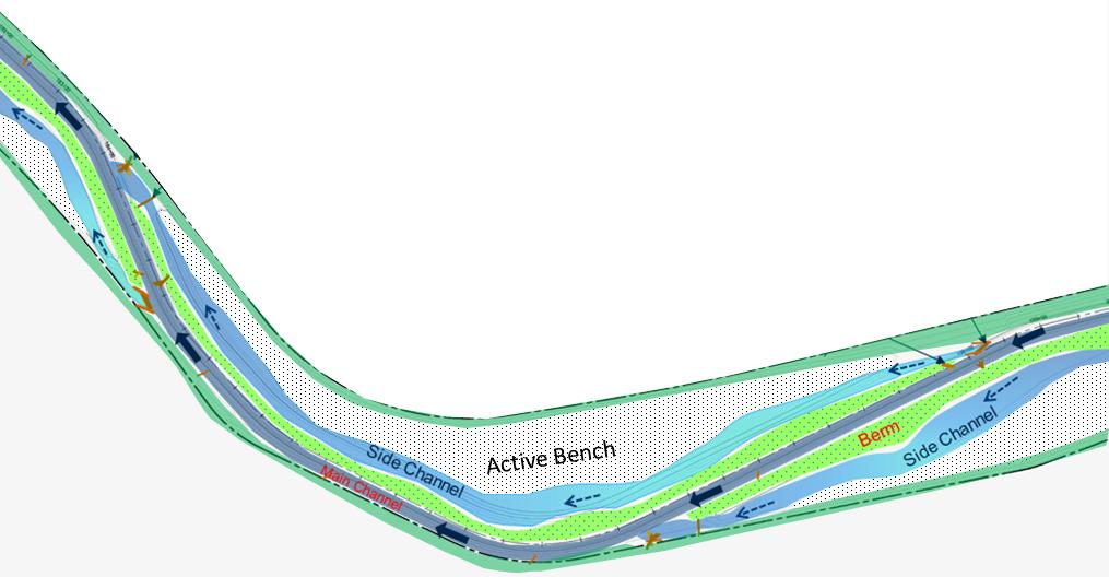
11 Phase 2: Salt River Channel and Riparian Floodplain Corridor Geomorphic and 2-D Hydraulic Modeling Design Approach
12 Riparian Planting along Channel Channel Cross-section Design
13 Channel Cross-section Design Effective Discharge: 86 cfs Exceeded 27 days/year
14 Channel Cross-section Design Full Active Channel Discharge: 138 cfs Exceeded 13 days/year
15 Channel Cross-section Design Berm Overtopping Discharge: 400 cfs Exceeded 1 day/year
16 Large Wood Used to Create Geomorphic Features Large Wood Design Considerations 1. Supports Geomorphic Channel Functions 2. Provides Aquatic Habitat Diversity 3. Reuses Onsite Materials 4. Designed for Minimal Maintenance 5. Meets Permit Requirements Riparian Planting along Channel

17 Log Sill Structures (Side Channel Inlet)


18 Revegetation Design Approach Revegetation Considerations 1. Compatible with geomorphic design and adjoining land uses 2. Short Term Erosion Control/SWPPP Compliance 3. Long Term Succession to Suppress Invasive Species 4. Permit Requirements (Planting Area and Species) 5. Freshwater and Brackish Habitats

19 Revegetation Design Approach

20 Revegetation Design Approach
21 Adaptive Management Plan (AMP) Long-term Monitoring and Management Program One of the Four Project Components Monitoring and management structure Identify monitoring components, triggering mechanisms and potential actions Relates project performance to goals & objectives Includes Roles for all Stakeholders Watershed Council HCRCD Landowners Regulatory Group Funders Technical Advisory Included in 10-year Permits Basis to Pursue Long-term Funding Opportunities
22 Adaptive Management Plan (AMP) Long-term Monitoring and Management Program The Structure The Process
SALT RIVER ECOSYSTEM RESTORATION PROJECT ADAPTIVE MANAGEMENT PLAN. Prepared by:
 SALT RIVER ECOSYSTEM RESTORATION PROJECT ADAPTIVE MANAGEMENT PLAN Prepared by: H. T. HARVEY & ASSOCIATES with Winzler & Kelly and Kamman Hydrology & Engineering Prepared for: Donna Chambers, Executive
1/30/2014. SR-BOK Outcomes. Sue Niezgoda, Gonzaga University January 28, Depth. Breadth
 SR-BOK Outcomes Sue Niezgoda, Gonzaga University January 28, 2014 Breadth Depth 1 Foundational Outcomes Hydrology Hydraulics Fluvial geomorphology Sediment Transport Stream Ecology Habitat Structure and
Scenario Modeling and Restoration Implications
 Scenario Modeling and Restoration Implications Paul Kolp 1, Matt Van Ess 2, Keith Marcoe 1, Sam Geisse 2 1 Lower Columbia Estuary Partnership 2 Columbia River Estuary Study Taskforce 1 Background Estuary
Jordan River Watershed Council STREAM FUNCTION INDEX (SFI)
") Jordan River Watershed Council STREAM FUNCTION INDEX (SFI) July 15, 2009 OUTLINE Stream Function Index (SFI) purpose, structure, and methodology SFI Data and Reports Recommendations and Opportunities What
Jordan River Watershed Council STREAM FUNCTION INDEX (SFI) July 15, 2009 OUTLINE Stream Function Index (SFI) purpose, structure, and methodology SFI Data and Reports Recommendations and Opportunities What
South St. Vrain / Hall Meadows Restoration Planning August 20, 2015
 South St. Vrain / Hall Meadows Restoration Planning August 20, 2015 Agenda Introductions Purpose & Goals of Meeting Planning Area Master Plan Restoration Planning: Cost Estimates, Grants, Scope, Timeline
TABLE OF CONTENTS. TOC-i
 TOC-i TABLE OF CONTENTS 1.0 INTRODUCTION... 1-1 Riparian Corridor Study and Management Plan Goals... 1-1 Study Area... 1-2 Importance and Functions of Riparian Corridors... 1-2 Habitat for Mammals, Birds,
Santa Ana River Watershed. SAWPA Celeste Cantú April 17, 2012
 Santa Ana River Watershed SAWPA Celeste Cantú April 17, 2012 What is SAWPA? SAWPA Member Agencies & Other Stakeholders Other Stakeholders 97 Water-related Agencies 4 Counties 59 Cities State water, environmental,
Multi-Benefit Planning in the San Joaquin River Basin-wide Feasibility Study
 Multi-Benefit Planning in the San Joaquin River Basin-wide Feasibility Study September 8 th, 2016 Presented by: Eric Tsai, P.E. California Department of Water Resources Eric.Tsai@water.ca.gov Jeremy Thomas,
Estuarine Restoration in San Francisco Bay: Design and Adaptive Management. Environmental Management of Enclosed Coastal Seas
 Estuarine Restoration in San Francisco Bay: Design and Adaptive Management Environmental Management of Enclosed Coastal Seas August 31, 2011 Eric Jolliffe, Bill Brostoff, and Fari Tabatabai U. S. Army
Agency Organization Organization Address Information. Name United States Department of Agriculture
 Logo Department Name United States Department of Agriculture Agency Organization Organization Address Information Forest Service Pacific Northwest Region 1220 SW Third Avenue (97204) P.O. Box 3623 Portland,
Hydrologic Regime; Past and Present and Water Quality Implications
 Hydrologic Regime; Past and Present and Water Quality Implications Waseca County Water Plan Meeting Waseca County Courthouse Annex November 16, 2016 Dan Girolamo, Area Hydrologist, Waterville, MN Topics
RIPARIAN CORRIDOR STUDY FINAL CITY CREEK MANAGEMENT PLAN TABLE OF CONTENTS
 TABLE OF CONTENTS 1.0 INTRODUCTION... 1-1 Riparian Corridor Study and Management Plan Goals... 1-1 Study Area... 1-2 Importance and Functions of Riparian Corridors... 1-2 Habitat for Mammals, Birds, and
Request for Proposal Scope Development Guide. Asotin County Geomorphic Assessment. and. Conceptual Restoration Plan
 Request for Proposal Scope Development Guide Asotin County Geomorphic Assessment and Conceptual Restoration Plan Asotin County Conservation District December 3, 2015 1 1.0 INTRODUCTION The Asotin County
Site Selection and Design for Stream Mitigation
 Site Selection and Design for Stream Mitigation Will Harman, PG Stream Mechanics The Association of State Wetland Managers State/Tribal/Federal Coordination Meeting March 19-21, 2013 NCTC Our Relationship
7.0 WATER-BASED CONTROL MEASURES
 7.0 WATER-BASED CONTROL MEASURES 7.1 IDENTIFICATION AND DESCRIPTION OF CONTROL MEASURES Table 7-1 lists the water-based options being considered for implementation in the initial screening stage. Descriptions
Battle Creek Salmon and Steelhead Restoration Project January 2017
 Battle Creek Salmon and Steelhead Restoration Project January 2017 Battle Creek has the unique geology, hydrology, and habitat suitability to support threatened and endangered Chinook salmon and Central
Successful Floodplain Reconnection
 Successful Floodplain Reconnection Design, Implementation, Monitoring and Adaptive Management Upper Truckee River, Lake Tahoe, California Michael Rudd, PE, Charley Miller PE, Virginia Mahacek, Chad Krofta
Surface Water. Solutions for a better world
 1 Surface Water Solutions for a better world Our Surface Water Services Expertise Growing worldwide awareness of water scarcity has encouraged water preservation programs, better irrigation techniques
RIPARIAN CORRIDOR STUDY FINAL PARLEYS CREEK MANAGEMENT PLAN TABLE OF CONTENTS
 TABLE OF CONTENTS 1.0 INTRODUCTION... 1-1 Riparian Corridor Study and Management Plan Goals... 1-1 Study Area... 1-2 Importance and Functions of Riparian Corridors... 1-2 Habitat for Mammals, Birds, and
ANCR INDIVIDUAL RESPONSES SUMMARY: 2/11/04 WATER RESOURCES GOALS AND OBJECTIVES
 ANCR INDIVIDUAL RESPONSES SUMMARY: 2/11/04 WATER RESOURCES GOALS AND OBJECTIVES Goal 1: Protect the health and safety of the Dane County population. a. Prevent development that may have an adverse effect
2.4 Floodplain Restoration Principles
 Floodplain Restoration Principles 2.4 Floodplain Restoration Principles Anthropogenic alternation of river corridors and floodplains significantly modified the structure and function of landscapes and
COASTAL CONSERVANCY. Staff Recommendation May 24, 2012 SALT RIVER ECOSYSTEM RESTORATION PROJECT: TOSTE ACQUISITION
 COASTAL CONSERVANCY Staff Recommendation May 24, 2012 SALT RIVER ECOSYSTEM RESTORATION PROJECT: TOSTE ACQUISITION Project No. 10-024-01 Project Manager: Michael Bowen RECOMMENDED ACTION: Authorization
Napa River Watershed Sediment TMDL Implementation and Habitat Enhancement
 Napa River Watershed Sediment TMDL Implementation and Habitat Enhancement Shaun Horne, Napa County Flood Control and Water Conservation District, shaun.horne@countyofnapa.org The Napa River drains an area
Introduction to stream assessment
 Why do stream assessment? Introduction to stream assessment Given the current condition of rivers and the heightened public interest in them, there is a significant need for the ability to determine the
Habitat Grant Projects Clinton River Watershed
 Habitat Grant Projects Clinton River Watershed L Y N N E S E Y M O U R E N V I R O N M E N T A L E N G I N E E R O F F I C E O F T H E M A C O M B C O U N T Y P U B L I C W O R K S C O M M I S S I O N
Environmental Protection (NJDEP) The Louis Berger Group, Inc.
 The Louis Berger Group, Inc.") Hydraulic Modeling for Preliminary Evaluation of Potential Flooding Impacts for Various Dredging, Capping and Armoring Scenarios of The Lower Passaic River Restoration Abdulai Fofanah, PE, D.WRE, CFM Murat
Hydraulic Modeling for Preliminary Evaluation of Potential Flooding Impacts for Various Dredging, Capping and Armoring Scenarios of The Lower Passaic River Restoration Abdulai Fofanah, PE, D.WRE, CFM Murat
Fort Clatsop Restoration Project Summary Report
 Fort Clatsop Restoration Project Summary Report Report written by the Columbia River Estuary Study Taskforce October, 2007 Figure 1: Site Map Fort Clatsop Estuarine Restoration Project Columbia River Estuary
3.14 EAST STRAIT INDEPENDENT DRAINAGES RECOMMENDATIONS
 Chapter 3.14 East Strait Independent Drainages Page 3.14-1 3.14 EAST STRAIT INDEPENDENT DRAINAGES RECOMMENDATIONS Section 3.4 contains recommendations for instream flows and Section 3.3 contains other
State of Vermont Culvert sizing based on the Stream Alteration General Permit
 State of Vermont Culvert sizing based on the Stream Alteration General Permit Northeastern Transportation and Wildlife Conference September 11, 2018 Todd Menees, PE River Management Engineer VT DEC Rivers
Plan Rollout Presentation July 31, Michael G. Hahn, P.E., P.H. Chief Environmental Engineer. Southeastern Wisconsin Regional Planning Commission
 Plan Rollout Presentation July 31, 2014 Michael G. Hahn, P.E., P.H. Chief Environmental Engineer Southeastern Wisconsin Regional Planning Commission # 219703 Racine County Flooding Recommendations and
Sue L. Niezgoda, Ph.D., P.E. Gonzaga University
 Sue L. Niezgoda, Ph.D., P.E. Gonzaga University Professional Certification or Licensure definitive minimum standard of experience and education for professionals broader recognition as well-educated and
Estuary Habitat Restoration STRATEGY 2012
 Estuary Habitat Restoration STRATEGY 2012 INTRODUCTION The Estuary Restoration Act of 2000 (ERA), as amended, (title I of Pub. L. 106 457) fosters a collaborative and comprehensive process among federal
Pajaro River Watershed Integrated Regional Water Management Plan Update Project Solicitation Form
 Pajaro River Watershed Integrated Regional Water Management Plan Update PROJECT OVERVIEW General Project Information Project Title: South County Recycled Water Pipeline - Short-Term CIP Implementation
4. Present Activities and Roles
 4. Present Activities and Roles The present missions, authorities, activities and roles of the various agencies involved with flood protection, floodplain management and flood-damage reduction are identified
Logan River at Rendezvous Park, Channel and Floodplain Restoration: Crack Willow (Salix fragilis) Issues and Management Strategies
 Issues and Management Strategies") Logan River at Rendezvous Park, Channel and Floodplain Restoration: Crack Willow (Salix fragilis) Issues and Management Strategies Prepared May 2, 2017 by Darren Olsen, BIO-WEST, Inc. Issues Crack willow
Logan River at Rendezvous Park, Channel and Floodplain Restoration: Crack Willow (Salix fragilis) Issues and Management Strategies Prepared May 2, 2017 by Darren Olsen, BIO-WEST, Inc. Issues Crack willow
U.S. ARMY CORPS OF ENGINEERS BUILDING STRONG LOS ANGELES DISTRICT
 PUBLIC NOTICE U.S. ARMY CORPS OF ENGINEERS BUILDING STRONG LOS ANGELES DISTRICT APPLICATION FOR PERMIT Goat Canyon Sedimentation and Basin Maintenance Dredging Project Public Notice/Application No.: SPL-2005-02068-RRS
The E.coli Reduction on the San Francisco River Through Alternative Livestock Water on Kaler Ranch Project, Phase II
 The E.coli Reduction on the San Francisco River Through Alternative Livestock Water on Kaler This project was funded by a grant from the United States Environmental Protection Agency and the Arizona Department
Burke Creek Highway 50 Crossing and Realignment Project Monitoring Plan
 Burke Creek Highway 50 Crossing and Realignment Project Monitoring Plan Table of Contents Table of Figures... i Introduction... 1 Background... 1 Burke Creek Issues... 2 Monitoring Objectives and Goals...
ECOSYSTEM HEALTH AND SALMON RESTORATION: A BROADER PERSPECTIVE
 Orr 1 ECOSYSTEM HEALTH AND SALMON RESTORATION: A BROADER PERSPECTIVE BRUCE K. ORR Stillwater Sciences, Berkeley, California, USA ABSTRACT An understanding of healthy, naturally functioning riverine and
South Bay Salt Pond Restoration Project Long-Term Restoration Planning
 South Bay Salt Pond Restoration Project Long-Term Restoration Planning State Coastal Conservancy, California Department of Fish and Game, and U.S. Fish and Wildlife Service Response to Summary of Recommendations
Environmental Flows Allocation Process in Texas. Kevin Mayes Texas Parks and Wildlife Department March 2010
 Environmental Flows Allocation Process in Texas Kevin Mayes Texas Parks and Wildlife Department March 2010 Senate Bill 3-2007 Environmental Flow Regime A schedule of flow quantities that reflects seasonal
Flood Protection Meets Climate Change
 Flood Protection Meets Climate Change Robin Grossinger, San Francisco Estuary Institute, robin@sfei.org Scott Dusterhoff, San Francisco Estuary Institute Julie Beagle, San Francisco Estuary Institute Climate
Tampa Port Authority
 McKay Bay Restoration (McKay Bay Mitigation Site and McKay Bay Dredge Hole Restoration) Tampa Port Authority 2014 AAPA Environmental Awards Competition June 2014 Contact: Andy Fobes, Director of Public
VEGETATIVE, WATER, FISH AND WILDLIFE RESOURCES POLICIES
 VEGETATIVE, WATER, FISH AND WILDLIFE RESOURCES POLICIES The County will: GOALS AND OBJECTIVES 1.1 Conserve, Enhance, Protect, Maintain and Manage Vegetative, Water, Fish and Wildlife Resources Promote
The Nature Conservancy Cosumnes River Preserve Franklin Boulevard Galt CA 95632
 Study Partners The Nature Conservancy Cosumnes River Preserve 13501 Franklin Boulevard Galt CA 95632 East Bay Municipal Utility District 1 Winemaker Way, Unit K Lodi CA 95240 Sacramento County Water Agency
Designing roads for fish, floods and foxes
 Designing roads for fish, floods and foxes Calculations 9 Swimming Plunging Flow & Leaping Occupied Velocity Prolonged > Capability Yes Swim in Burst Total Time in Burst Time to > Exhaustion Yes Barrier
New Castle County, DE. Floodplain Regulations
 New Castle County, DE Floodplain Regulations John J. Gysling, PE CFM Department of Land Use New Castle County, DE February 26, 2009 Today s Presentation Floodplain Protection and Uses Terms and Definitions
Water and Watersheds. Data Maps Action
 Water and Watersheds Data Maps Action What is the Wildlife Action Plan? Restore rare wildlife and habitats. Keep common species common. 2015 Revision: Partners in Conservation Science 2015 Revision Data
Department of the Army Permit Application
 Department of the Army Permit Application DA File Number U.S. Army Corps of Engineers Honolulu District Date Received by CEPOH-RO Send Completed Application to: Honolulu District, U.S. Army Corps of Engineers
County of San Diego DEPARTMENT OF PARKS AND RECREATION. Administrative Office: (858) Fax: (858) Reservations: (858)
 Fax: (858) Reservations: (858)") BRIAN ALBRIGHT DIRECTOR County of San Diego DEPARTMENT OF PARKS AND RECREATION Administrative Office: (858) 694-3030 Fax: (858) 495-5841 Reservations: (858) 565-3600 www.sdparks.org NOTICE OF PREPARATION
BRIAN ALBRIGHT DIRECTOR County of San Diego DEPARTMENT OF PARKS AND RECREATION Administrative Office: (858) 694-3030 Fax: (858) 495-5841 Reservations: (858) 565-3600 www.sdparks.org NOTICE OF PREPARATION
Ecohydrology Research Vision. SCCWRP Commission Meeting December 4, 2015
 Ecohydrology Research Vision SCCWRP Commission Meeting December 4, 2015 Roadmap for Today What is Ecohydrology? Why is Ecohydrology important? How does SCCWRP s Ecohydrology research vision relate to policy
Project Goals and Scoping
 Prepared for: Boulder County, Colorado Flood Planning & Preliminary Design Services for South St. Vrain Creek Restoration at Hall Ranch and Scoping May 24, 2016 Meeting with General Public In association
BOSTON BAY HABITAT REHABILITATION AND ENHANCEMENT PROJECT (HREP) MERCER COUNTY, ILLINOIS
 MERCER COUNTY, ILLINOIS") BOSTON BAY HABITAT REHABILITATION AND ENHANCEMENT PROJECT (HREP) MERCER COUNTY, ILLINOIS UPPER MISSISSIPPI RIVER RESTORATION ENVIRONMENTAL MANAGEMENT PROGRAM ROCK ISLAND DISTRICT FACT SHEET I. LOCATION
BOSTON BAY HABITAT REHABILITATION AND ENHANCEMENT PROJECT (HREP) MERCER COUNTY, ILLINOIS UPPER MISSISSIPPI RIVER RESTORATION ENVIRONMENTAL MANAGEMENT PROGRAM ROCK ISLAND DISTRICT FACT SHEET I. LOCATION
There is a reliable, clean water supply for current and future generations.
 E2 There is a reliable, clean water supply for current and future generations. E2.1. Current and future water supply for municipalities, industries, agriculture, and the environment is reliable. 2.1.1.
WHY ARE STREAM IMPROVEMENTS NEEDED IN TENNESSEE? TENNESSEE STREAMS
 WHY ARE STREAM IMPROVEMENTS NEEDED IN TENNESSEE? TENNESSEE STREAMS Most diverse aquatic fauna in the country Majority of West TN streams are channelized 36,000 miles of degraded stream are in need of restoration
Incorporating Restoration Planning and Transportation Controls into the Valley Creek Watershed Act 167 Stormwater Management Plan
 Incorporating Restoration Planning and Transportation Controls into the Valley Creek Watershed Act 167 Stormwater Management Plan Pennsylvania State Section American Water Resources Association Fall 2011
Appendix 3-B: Limiting Factors Analysis
 Appendix 3-B: Limiting Factors Analysis WRIA 18 Watershed Plan Limiting Factors Analysis for WRIA 18, Recommendations Page 1 Salmon and Steelhead abitat Limiting Factors WRIA 18 Lead Agency: Washington
Restoration of Riparian Forests and Riparian Ecosystem Processes and Implications for Salmon Restoration. Katie Ross-Smith Jennifer Hammond
 Restoration of Riparian Forests and Riparian Ecosystem Processes and Implications for Salmon Restoration Katie Ross-Smith Jennifer Hammond Outline > Background California riparian communities Riparian
Appendix K: Preliminary Project Assessment
 Appendix K: Preliminary Project Assessment Appendix K provides the MCG-approved preliminary assessment of concepts. This assessment determined if project concepts were feasible, beneficial, attainable,
COON CREEK WATERSHED DISTRICT PERMIT REVIEW
 16-054 Woodland Creek Wetland Banking Restoration Project, Page 1 of 6 COON CREEK WATERSHED DISTRICT PERMIT REVIEW MEETING DATE: August 22, 2016 AGENDA NUMBER: 11 FILE NUMBER: 16-054 ITEM: Woodland Creek
HYDRAULIC CONNECTIVITY (HC) ENGINEERING & HYDRAULICS PERSPECTIVES
 ENGINEERING & HYDRAULICS PERSPECTIVES") HYDRAULIC CONNECTIVITY (HC) ENGINEERING & HYDRAULICS PERSPECTIVES Presented at the UMRR HREP Team Meeting September 28, 2016 Jon Hendrickson Regional Technical Specialist, Eco-Hydraulics & WQ USACE, Mississippi
HYDRAULIC CONNECTIVITY (HC) ENGINEERING & HYDRAULICS PERSPECTIVES Presented at the UMRR HREP Team Meeting September 28, 2016 Jon Hendrickson Regional Technical Specialist, Eco-Hydraulics & WQ USACE, Mississippi
jmt.com WATER RESOURCES MANAGEMENT Part of a diversified family of solutions
 jmt.com WATER RESOURCES MANAGEMENT Part of a diversified family of solutions About Us Johnson, Mirmiran & Thompson (JMT) is a multidisciplined engineering and architectural firm serving clients throughout
Clarks Fork of the Yellowstone Comprehensive River Management Plan
 Clarks Fork of the Yellowstone Comprehensive River Management Plan Background The Clarks Fork of the Yellowstone River is located on the Shoshone National Forest, approximately 30 miles north-northwest
Riparian Buffers and Stream Restoration
 Riparian Buffers and Stream Restoration Why focus on riparian areas? Link land and water on any given site and link landscapes together in a watershed Riparian corridors protect the circulatory system
COASTAL CONSERVANCY. Staff Recommendation June 16, 2005 ESTERO AMERICANO NATURE PRESERVE ENHANCEMENT PROJECT
 COASTAL CONSERVANCY Staff Recommendation June 16, 2005 ESTERO AMERICANO NATURE PRESERVE ENHANCEMENT PROJECT File No. 05-017 Project Manager: Richard Retecki RECOMMENDED ACTION: Authorization to disburse
Support legislation that will protect the quantity of water in Lake Erie
 Specific Regional Priorities Each of Pennsylvania s major drainage basins has an array of individual characteristics that distinguish it from other regions of the state. These include diverse geographic
COASTAL TX PROTECTION AND RESTORATION FEASIBILITY STUDY
 COASTAL TX PROTECTION AND RESTORATION FEASIBILITY STUDY Stakeholders Forum Dr. Kelly Burks-Copes, Project Manager Mr. Tony Williams, Coastal Resources US Army Corps of Engineers, Galveston District Texas
Chapter 4 Watershed Goals and Objectives
 Chapter 4 Watershed Goals and Objectives Eight (8) long-term watershed goals have been developed by the NEW Watershed Advisory Group (WAG) after consideration of discussions held during monthly watershed
APPENDIX P EL DORADO COUNTY GENERAL PLAN: APPLICABLE SECTIONS FROM CONSERVATION AND OPEN SPACE ELEMENT
 APPENDIX P EL DORADO COUNTY GENERAL PLAN: APPLICABLE SECTIONS FROM CONSERVATION AND OPEN SPACE ELEMENT SOIL CONSERVATION OBJECTIVE 7.1.2: EROSION/SEDIMENTATION Minimize soil erosion and sedimentation.
Headwater Wetland Restoration Techniques The Wetland Drain Restoration Project
 Headwater Wetland Restoration Techniques The Wetland Drain Restoration Project Tools for Managing Small Drainage Features in Rural Landscapes Workshop, March 5, 2014 Dave Richards, Partnership Specialist,
Water Supply and Delivery
 Utilities Water Supply and Delivery Goal U-1 Availability of an adequate, safe, and sustainable water supply and maintenance of an efficient water system for residents and visitors. (Modified Goal 4.B)
Retrospective Evaluation of Completed Corps Aquatic Ecosystem Restoration Projects. David Price, Craig Fischenich, Erynn Maynard, Justin Gardner
 Retrospective Evaluation of Completed Corps Aquatic Ecosystem Restoration Projects David Price, Craig Fischenich, Erynn Maynard, Justin Gardner Objectives Environmental Benefits/Outcomes What are the environmental
Yakima Tributary Access & Habitat Program Summary of Accomplishments Diversion 14 Fish Passage and Screening, 2003 Ahtanum Creek
 Yakima Tributary Access & Habitat Program Summary of Accomplishments Diversion 14 Fish Passage and Screening, 2003 Ahtanum Creek This early action project involved removing a fish passage barrier, screening
Unify efforts to address water resources for the Big Sky area and surrounding zone of influence in three co-equal water resources focus areas:
 EXECUTIVE SUMMARY The Big Sky Sustainable Water Solutions Forum (Water Forum) is a community-based, collaborative approach building a unified vision for future Big Sky water resources management to maintain
Lessons Learned from the Jocko River Demonstration Project
 Lessons Learned from the Jocko River Demonstration Project Applied Adaptive Management Matt Daniels, P.E. Presentation Objectives Provide a brief overview of the project context. Describe the monitoring
TABLE OF CONTENTS. Introduction. Lower Platte South NRD Past and Present 1. Map of Lower Platte South NRD 2. Vision for the Future 3.
 TABLE OF CONTENTS Introduction ii Lower Platte South NRD Past and Present 1 Map of Lower Platte South NRD 2 Vision for the Future 3 Vision Table 5 i INTRODUCTION The Master Plan is the document that expresses
PART 4 GOALS, POLICIES AND ACTIONS
 Goleta Slough Area Sea Level Rise and Management Plan Goals, Policies and Actions PART 4 GOALS, POLICIES AND ACTIONS 4.1 1997 GSEMP Goals, Policies and Actions The 1997 Goleta Slough Ecosystem Management
Priorities & Metrics Workgroup Proposed Vision, Mission, Goals, Objectives, and Targets
 Priorities & Workgroup Proposed Vision, Mission, Goals, Objectives, and November 28, 2012 Vision: An integrated, balanced, and consensus-based approach to ensuring the long-term sustainability of the Region
Regional Watershed Planning. Calumet Summit 2010: A Call to Connect Calumet Conference Center April 27, 2010
 Regional Watershed Planning Calumet Summit 2010: A Call to Connect Calumet Conference Center April 27, 2010 Basins The Calumet Region Watershed Communities Land Cover- 2006 Impervious Cover 303d Listed
Wood-Pawcatuck Watershed Flood Resiliency Management Plan
 Wood-Pawcatuck Watershed Flood Resiliency Management Plan Project Steering Committee Meeting May 21, 2015 Wood-Pawcatuck Watershed Association Meeting Agenda 10:00 10:05 Welcome and Opening Remarks 10:05
June 22, Francis E. Borcalli, P.E.
 CACHE CREEK SETTLING BASIN SYMPOSIUM Managing the Settling Basin Who s Doing What! June 22, 2009 Francis E. Borcalli, P.E. CACHE CREEK SETTLING BASIN SYMPOSIUM Managing the Settling Basin Who s Doing What!
INDIAN CREEK WATERSHED PLAN EXECUTIVE SUMMARY
 INDIAN CREEK WATERSHED PLAN EXECUTIVE SUMMARY The Indian Creek Watershed covers a 38 square mile area in southern Lake County, Illinois that drains 24,116 acres before discharging into the Des Plaines
Study Introduction and Meeting Overview Laurel Marcus
 Study Introduction and Meeting Overview Laurel Marcus PURPOSE OF ISRP In the Russian River watershed river and stream ecology are inextricably linked to surface and groundwater interactions. Essential
Chapter 5: Water Quality Buffer Requirements
 Chapter 5: Water Quality Buffer Requirements 5.1 Introduction Water quality buffer requirements apply to all new land development or redevelopment containing streams or other water bodies such as ponds,
Wetlands Project Guidance
 HABITAT Wetlands Project Guidance Stakeholder Informed Introduction Wetlands are lands saturated with water permanently or seasonally. Wetlands are typically defined by three characteristics: 1) The area
Ch. 1: Watersheds and Wetlands. Lesson 1.5: Factors That Affect Wetlands and Watersheds Part 2
 Ch. 1: Watersheds and Wetlands Lesson 1.5: Factors That Affect Wetlands and Watersheds Part 2 Index of Watershed Indicators (IWI) The Index is a compilation of information on the "health" of aquatic resources
Get the Rock Out: Engineered wood structures for stream restoration. Joe Berg, Doug Streaker, Matt Koozer and Kevin Nunnery Biohabitats, Inc.
 Get the Rock Out: Engineered wood structures for stream restoration Joe Berg, Doug Streaker, Matt Koozer and Kevin Nunnery Biohabitats, Inc. Examples of Wood Structures in Stream Design Root wads one of
Surface Water Improvement and Management (SWIM) Plan Development
 Plan Development") Surface Water Improvement and Management (SWIM) Plan Development Bay Area Resource Council TAC Paul Thorpe Chief, Bureau of Environmental May 17, 2017 and Resource Planning May 17, 2017 Surface Water Improvement
Surface Water Improvement and Management (SWIM) Plan Development Bay Area Resource Council TAC Paul Thorpe Chief, Bureau of Environmental May 17, 2017 and Resource Planning May 17, 2017 Surface Water Improvement
Iterative Planning of Ecological Restoration and its Incorporation into Soil and Groundwater Remediation
 Woodbridge, New Jersey Iterative Planning of Ecological Restoration and its Incorporation into Soil and Groundwater Remediation Monica LaSelva July 31 2014 Site Description 185 acre site in Woodbridge,
Overview of ENVISION: A Sustainability Rating System for Infrastructure Projects
 Houston, Texas May 19, 2016 Overview of ENVISION: A Sustainability Rating System for Infrastructure Projects Michael F. Bloom, P.E., CFM, ENV SP, BCEE Manager, Sustainability Practice TOPICS Who is ISI?
WATERSHED MANAGEMENT INITIATIVE: GOALS & IMPLEMENTATION OBJECTIVES, JULY 26, 1999
 WATERSHED MANAGEMENT INITIATIVE: GOALS & IMPLEMENTATION OBJECTIVES, JULY 26, 1999 The following table indicates the draft goals and objectives for the Santa Clara Basin WMI process. The overall objectives
Maitland Valley WATERSHED
 Maitland Valley WATERSHED Report Card 2018 Maitland Conservation has prepared this report card as a summary of the state of your forests, wetlands, and water resources. WHERE ARE WE? We are one of 36 Conservation
Table D1: WC-R1 to WC-R3 (Wilket Creek Park)
") APPENDIX D Table D1: WC-R1 to WC-R3 (Wilket Creek Park) Category of Consideration Criteria Alternative 1 Do Nothing Alternative 2 Local Improvements Alternative 3 Channel Realignment Natural Geomorphic
APPENDIX D Table D1: WC-R1 to WC-R3 (Wilket Creek Park) Category of Consideration Criteria Alternative 1 Do Nothing Alternative 2 Local Improvements Alternative 3 Channel Realignment Natural Geomorphic
Natural Channel Design and Dead River Case Study Stream Restoration in the Great Lakes Basin: Using In-stream Structures & Natural Channel Design
 Natural Channel Design and Dead River Case Study Stream Restoration in the Great Lakes Basin: Using In-stream Structures & Natural Channel Design January 22, 2013 S. Paige Baker, PE, MLE Presentation Outline
Mukwonago River Watershed Protection Plan Recommendations & Implementation Update Friends of Mukwonago River March 16, 2013 Mukwonago, WI
 Mukwonago River Watershed Protection Plan Recommendations & Implementation Update Friends of Mukwonago River March 16, 2013 Mukwonago, WI Thomas M. Slawski, Principal Specialist Biologist Southeastern
Charlotte Harbor SWIM Plan Update Proposed Quantifiable Objectives and Management Actions, January 2019
 Management Actions One of the goals of this SWIM plan is to identify strategic initiatives that will address the major issues and drivers and provide management actions that will improve and maintain the
Don Catchment Vision
 Don Catchment Vision Don Catchment Vision A healthy and biodiverse catchment that is valued and enjoyed, contributing to the economic and social well-being of local communities. Aims for the Don To identify
Appendix E Habitat Vulnerability Summary Sheets
 Habitat Vulnerability Summary Sheets Table of Contents Item No. Title Page Table SH-1 Freshwater Marsh / Willow Woodland Habitat Summary 2 Figure SH-1 Freshwater Marsh 2100 SLAMM Results Without Tide Gate
5/1/2013. Puget Sound Conditions. LID research, data, guidelines, specifications, and regulations are evolving rapidly.
 The goal of these workshops is to give designers, builders and managers the technical details necessary to properly design, construct and maintain LID facilities. LID research, data, guidelines, specifications,
CITY OF SASKATOON COUNCIL POLICY
 POLICY TITLE ORIGIN/AUTHORITY Clause 2, Report 18 2006 of the Planning and Operations Committee; Clause 4, Report No. 16-2013 of the Planning and Operations Committee; and Hearing 3b, dated. ADOPTED BY: