GIS Based Assessment Effect of Irrigation on Groundwater Level Changes in Agricultural Areas: A Case Study: Bismil plain in the Upper Tigris Basin.
|
|
|
- Benjamin Smith
- 5 years ago
- Views:
Transcription


1 II. Geology Conferences DUBAI April, 201 GIS Based Assessment Effect of Irrigation on Groundwater Level Changes in Agricultural Areas: A Case Study: Bismil plain in the Upper Tigris Basin. Asst. Proff. Dr. Recep ÇELIK Dicle University Engineering Faculty. Civil Engineering Department, Diyarbakır/TURKEY.
2 1. INTRODUCTION
3 Groundwater has used for long time as an alternative source in landscape irrigation or when city water falls short. Initially for every city center, tap water and landscape irrigation requirements can be provided by groundwater sources, these sources should be observed regularly and databases should be created.
4 Geographic Information System (GIS) is a computer program which is used as an extremely popular in recent years.

5 Static Water Level 1. Elevation or level of the water table in a well when the pump is not operating. 2. The level or elevation to which water would rise in a tube connected to an artesian aquifer or basin in a conduit under pressure. Fig.1: Well schema
6 Economic activities at Bismil, a district of the Diyarbakir province, depend mainly on agriculture and animal husbandry in the Upper Tigris Basin. Tigris River lies through the middle part of the Bismil plain. Bismil plain agricultural irrigation obtain especially from groundwater by well.
7 At coast of Tigris River irrigation provide from by pumping the water directly from the river during the irrigation session. However, as the consumption is more than feeding of the groundwater resources poses a serious threat for the groundwater resources..
8 2. MATERIALS


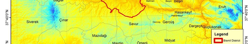

9 2.1.Study Area Figure 2. Study Area DEM map
10 The geographical location coordinates of Bismil district centre is 37 50'45'' N, 40 40'33'' E, and Bismil is the second largest county in the province of Diyarbakir. It is located in the South eastern Anatolia region of Turkey. Settled on a flat land, it has fertile land of the Tigris plain. The Tigris River passes through Bismil. There are slight hills to its north and south. The South-eastern Toros Mountains are located on the south side of Bismil. Its distance from Diyarbakır is 55 kilometers
11 2.1.2 Rivers and Lakes: The Tigris River runs through Bismil, and many small and large streams and creeks flow into it. The most important ones among these streams are Pamuk, Göksu, Kurmuslu, Kuru, Ambar, Caferi and Salat streams. Not exactly blessed with many lakes, Bismil has only one, which is near the Çöltepe village.


12 2.2 Diyarbakir s Hydrogeological Features Figure 3. Diyarbakır city Geological map
13 Geological formations that are rich by groundwater are formations that contain limestone, pebble and sandstone (Figure 3). Paleoasen old, limestone, clayey and marl formations don t have groundwater. Bismil s main water table spring is Midyat aquifer. Midyat aquifer s general construction is limestone and has two different flux units. First unit is 160 meter depth, low permeable and second unit is 90 meter depth and is more permeable then first unit.
14 3. METHODS
15 In the study, 316 wells drilled by public institutions such as DSİ, District Governorships, Special Provincial Administration, as well as private persons for watering purposes between the years have been examined. The drilling data was ranked via the Microsoft Excel software, and the coordinates have been arranged accordingly. These data was run on the ARC Map software. The data that have been converted to Shape (shp) format have been modelled through Spatial analyse extension Interpolation IDW tools.
16 In the following maps, a basemap has been prepared through Open Street Maps and Contributes found under the Arc Info software. UTM Datum has been used as projection. Static water level maps relevant to the years I (Figure 4), II (Figure 5), III (Figure 6), IV (Figure 7) have been obtained through all these processes.
17 Changes in the groundwater levels relevant to the nominated years have been detected using these maps. The settlement examples and groundwater graphic changes of the Bismil district and its villages have been drawn (figures 7, 8 and 9) with these maps. In the light of this data, results have been obtained. Otherwise all term of groundwater changes raster data had been analysed with spatial analyst local cell statistics menu. Results figure shows in figure 13.
18 4. RESULTS


19 Figure years Tigris Bismil region Static Water Level (SWL) Thematic Map


20 Figure years Tigris Bismil region Static Water Level (SWL) Thematic Map


")
21 Figure years Tigris Bismil region Static Water Level (SWL) Thematic Map


")
22 Figure years Tigris Bismil region Static Water Level (SWL) Thematic Map
23 RESULTS
24 static water depth from ground(m) Bismil Centre trendline of Bismil Bismil Centre Figure 8. Bismil Centre SWL changes
25 static water depth from ground(m) Ișıklar Serçeler Trendline of Isıklar Trendline of Serceler North- West Figure 9. North-West Region SWL changes
26 static water depth from ground(m) Uğrak Trendline of Ugrak North Figure 10. Bismil North Region SWL changes
27 static water depth from ground(m) Ambar Bakacak Linear (Ambar) Trend of Bakacak West Figure 11.Bismil West Region SWL(changes)
28 static water depth from ground(m) Babahaki Yukarısalat Trendline of Babahaki Trendline of Y.salat South -East Figure 12. Bismil South-East Region SWL changes

29 Figure 13. Bismil terms mean SWL value changes
30 Following conclusions have been obtained from thematic maps groundwater changes are classified relevant to urban centre (Figure 7), North- West(Figure 8), North (Figure 9), West(Figure 10), South, South-East, East and South West region.
31 The groundwater levels in all other regions show a significant dropped. Even though it is known that groundwater levels have some small seasonal changes. In the Bismil settlement area the static water levels have dropped by over meters. Especially after the year 2005, the groundwater levels have started to decrease increasingly. For example, in the Türkmenhaci village it has dropped from 4.8 meters in to 15.1 meters the years between
32 It has further dropped from 47 meters between down to 103 meters between Such changes are also found in other areas of the settlement as well. The main reasons for this were the insufficient precipitation during the years , and the use of the groundwater resources more than their feeding.

33 (Precipitation) (Trend of precipitation) Figure 14. Bismil Precipitation changes last 50 years
34 140, ,000 total population urban pop 100,000 rural pop 80,000 60,000 40,000 20, Figure 15. Bismil population changes last 40 years
35 It can also be claimed that the unauthorized water wells drilled in the area have an important effect on these dramatic changes in groundwater levels. The groundwater level in Central Bismil that was at 12 meters between the years decreased up to 73 meters between the years The groundwater level in Isıklar village was 17 meters between the years has gone down to 73 meters between the years
36 From the 2000 years, rural and urban population of Bismil is steadily. Whereas as seen Figure 7-12 groundwater level change is decreased after period sharply. So effect of population growth on groundwater is low.
37 In Bismil region, 60,000 decares of cotton, 2,500 decares of tobacco are cultivated (TUIK 2011). These crops needs more water. Besides, production of other field crops also carried out using groundwater. That would be main effect of groundwater level decrease.
38 According to DVCSIM 2013 report, In Bismil groundwater used 0,92 hm3/years water for drinking, hm3/year water for irrigation. While it seeding groundwater average is 31,25 hm3/year. There is huge negative budge about groundwater consumption and seeding. That would be main reason groundwater decrease.
39 Conclusıon
40 Groundwater level dropped average meters in Bismil central, Northern and Western Region. South, southwest and south-eastern regions of the groundwater static level dropped average 82 m (figure 13). This change occurred especially after 2005 years.
41 Population and climate effect is very low rather than groundwater using for irrigation effect. So that the main reason of groundwater level decrease is using water for irrigation unconscious in the semi arid region.
42 There would be main 3 factor effect the groundwater change(table 1); I. Population growth, II. III. Climate effect on precipitation Groundwater use for irrigation unconscious.
43 Table1: Potential effects on groundwater level changes Criteria Criterian Weight Effect rating results Population 0,15 1 0,15 Precipation 0,45 3 1,35 Irrigation Use 0,4 8 3,2
44 Population and climate effect is very low rather than groundwater using for irrigation effect. Precipitation affect is more effective than population growth rate. So that the main reason of groundwater level decrease is using water for irrigation unconscious in the semi arid region.
45 Suggestions: In the agricultural area, using groundwater must be under control. (The using groundwater must be reducing at least %70 for irrigation in the Bismil plain.) Additionally special watering projects such as GAP Projects should be executed as soon as possible. The need to use groundwater resources should be eliminated. In this manner the groundwater resources can reach at a balanced acceptable level by the time passes.
46 THANK YOU
Determination of Tigris Bismil Agricultural Plain s Groundwater Static Water Level (SWL) Changes Caused by Irrigation Using GIS Technic.
 Changes Caused by Irrigation Using GIS Technic.") International Refereed Journal of Engineering and Science (IRJES) ISSN (Online) 2319-183X, (Print) 2319-1821 Volume 6, Issue 2 (February 217), PP.1-6 Determination of Tigris Bismil Agricultural Plain s
International Refereed Journal of Engineering and Science (IRJES) ISSN (Online) 2319-183X, (Print) 2319-1821 Volume 6, Issue 2 (February 217), PP.1-6 Determination of Tigris Bismil Agricultural Plain s
MANAGEMENT OF MANURE FROM LIVESTOCK HOUSING IN TIGRIS BASIN AND ITS ENVIRONMENTAL POTENTIAL IMPACT.
 MANAGEMENT OF MANURE FROM LIVESTOCK HOUSING IN TIGRIS BASIN AND ITS ENVIRONMENTAL POTENTIAL IMPACT Atilgan Atilgan 1, Burak Saltuk 2, Hasan Oz 1, Ozan Artun 3 1 Süleyman Demirel University, Turkey; 2 Siirt
1. Introduction. Keywords Groundwater, Vulbnerability, Aquifer, Aquitard, Vadose zone. Alsharifa Hind Mohammad
 World Environment 2014, 4(1): 22-32 DOI: 10.5923/j.env.20140401.03 New Groundwater Vulnerability Index for the Main Aquifers in Central Catchment Area in Jordan and Validation of the Results Using NO 3
Water resource utilization and the agricultural economy development in rural China
 Int. Statistical Inst.: Proc. 58th World Statistical Congress, 2011, Dublin (Session IPS104) p.1585 Water resource utilization and the agricultural economy development in rural China Abstract:Our paper
Water Resources CHOIR in China
 Water Resources CHOIR in China Strategic research and innovation priorities for water Liu Dengwei 水利部发展研究中心 Development Research Center of the Ministry of Water Resources of China Water Resources CHOIR
S1004 The Groundwater Survey by using Resistivity Method and its Application in the Republic of Rwanda
 S1004 The Groundwater Survey by using Resistivity Method and its Application in the Republic of Rwanda K. Nakamura* (NTC International Co., Ltd.), T. Aizawa (Suncoh Consultants Co., Ltd.), S. Matsuda (NTC
Groundwater Governance in the Zhengzhou region, China
 Groundwater Governance in the Zhengzhou region, China Menggui JIN School of Environmental Studies China University of Geosciences Wuhan, Hubei 430074, China Email: mgjin@cug.edu.cn 1 Background of Zhengzhou
EAST TORRANCE SOIL AND WATER CONSERVATION DISTRICT. LONG RANGE PLAN July 1, 2009 June 30, 2019
 EAST TORRANCE SOIL AND WATER CONSERVATION DISTRICT LONG RANGE PLAN July 1, 2009 June 30, 2019 INTRODUCTION The East Torrance Soil and Water Conservation District covers 1,142,028 acres of land in Torrance
POLLUTION POTENTIAL OF GROUND- WATER RESOURCES IN ANTALYA CITY
 POLLUTION POTENTIAL OF GROUND- WATER RESOURCES IN ANTALYA CITY Mustafa Yildirim and Bulent Topkaya Akdeniz University, Department of Environmental Engineering, Topcular, 07200 Antalya, Turkey Presented
groundwater. Because watersheds are complex systems, each tends to respond differently to natural or human activities.
 The private development of Altos del María is located at an altitude between 550 and 1,000 meters above sea level in the environmentally sensitive Cordillera Central of Panama that separates the Pacific
ASSESSMENT OF GROUNDWATER VULNERABILITY GIS BASED DRASTIC MODEL: A CASE STUDY OF SIPCOT- PERUNDURAI, ERODE
 ISSN: 0974-1496 e-issn: 0976-0083 CODEN: RJCABP http://www.rasayanjournal.com http://www.rasayanjournal.co.in USING GIS BASED DRASTIC MODEL: A CASE STUDY OF SIPCOT- PERUNDURAI, ERODE Department of Civil
GIS APPLICATION IN GROUNDWATER QUALITY ESTIMATION
 GIS APPLICATION IN GROUNDWATER QUALITY ESTIMATION CRP 514 Term Paper Hatim H. Gazaz 5/18/2013 ID #: 200903270 Table of Contents GIS Application in Groundwater Quality Estimation 2013 TABLE OF CONTENTS...
Potential effects evaluation of dewatering an underground mine on surface water and groundwater located in a rural area
 Potential effects evaluation of dewatering an underground mine on surface water and groundwater located in a rural area ITRODUCTIO Michel Mailloux* Eng. M.Sc, Vincent Boisvert, M.Sc, Denis Millette, Eng.,
EFC Working Party on the Management of Mountain Watersheds
 EFC Working Party on the Management of Mountain Watersheds 27th Session Štrbské Pleso, Slovak Republic, 7-10 April 2010 NATIONAL REPORT OF TURKEY National Report of TURKEY 1. Introduction Turkey attended
Geography of the Fertile Crescent
 Geography of the Fertile Crescent If YOU were there You are a farmer in Southwest Asia about 6,000 years ago. You live near a slowmoving river, with many shallow lakes and marshes. The river makes the
Uncontrolled Urban Expansion of Amman City and the Disintegration of the Rainfed Lands
 Architecture Research 2017, 7(1): 24-28 DOI: 10.5923/j.arch.20170701.03 Uncontrolled Urban Expansion of Amman City and the Disintegration of the Rainfed Lands Numan Abu Hammad Department of Civil Engineering,
Scoring Groundwater Infiltration & Sewage Exfiltration Risk in a Sanitary Sewage Collection System. Meredith S. Moore Advisor: Dr.
 Scoring Groundwater Infiltration & Sewage Exfiltration Risk in a Sanitary Sewage Collection System Meredith S. Moore Advisor: Dr. Barry Evans July 20, 2015 Contents List of Figures... 2 List of Tables...
Issue paper: Aquifer Water Balance
 Issue paper: Aquifer Water Balance 1. Introduction And Background 1.1. Purpose and Scope The population in Kitsap County has grown rapidly in recent years and is expected to increase substantially in the
GEOGRAPHY OF THE FERTILE CRESCENT. Chapter 3 Section 1
 MESOPOTAMIA GEOGRAPHY OF THE FERTILE CRESCENT Chapter 3 Section 1 Land Between Two Rivers The Tigris and Euphrates rivers are the most important physical features of the region sometimes known as Mesopotamia
N. Africa & S.W. Asia
 N. Africa & S.W. Asia CHAPTER #8, SECTION #1 Identifying Boundaries Three Regions North Africa (Border Mediterranean and Red Seas) Morocco, Western Sahara, Algeria, Egypt, Sudan, Tunisia, & Libya Southwest
Regional Groundwater Flow Modeling of Yarkant Basin in West China
 Conference on Environmental Pollution and Public Health Regional Groundwater Flow Modeling of Yarkant Basin in West China Sun Jinyu Zhang Qiang Xu Mo College of Environment and Civil Engineering, Chengdu
Afghanistan. A Countrywide Overview of Groundwater Resources and Challenges By: Vincent W. Uhl
 Afghanistan A Countrywide Overview of Groundwater Resources and Challenges By: Vincent W. Uhl Country Overview Area: 647,500 km 2 Population: +/- 30 Million Economy: Principally Agriculture ¾ of the country
A Visualization of Water Resources in Montgomery County, Texas By James Bronikowski
 A Visualization of Water Resources in Montgomery County, Texas By James Bronikowski Introduction: Groundwater has been a cheap reliable source of water since people first began settling the upper gulf
Examples of Impact of Past Water Management and Geologic Setting on Resilient Water Planning
 Examples of Impact of Past Water Management and Geologic Setting on Resilient Water Planning Alex Rinehart 63rd Annual Water Conference 17-18 October 2018 Future water supply governed by geology and past
Human impacts on groundwater resources in Iran
 Man's Influence on Freshwater Ecosystems and Water Use (Proceedings of a Boulder Symposium, July 1995). IAHS Publ. no. 230, 1995. 141 Human impacts on groundwater resources in Iran ALI VALI-KHODJEINI Irrigation
13 Water: A Limited Resource
 13 Water: A Limited Resource Overview of Chapter 13 Importance of Water Water Use and Resource Problems Water Problems in U.S. and Canada Global Water Problems Water Management Water Conservation Water
South Platte River Watershed Study
 South Platte River shed Study Burns Meeting January 25, 2017 Sponsored by the Laramie County Conservation District Funded by the Wyoming Development Commission Meeting Outline South Platte River shed shed
AQUIFERS OF THE SAN ANTONIO RIVER BASIN
 AQUIFERS OF THE SAN ANTONIO RIVER BASIN OBJECTIVES Explain what an aquifer is Identify the major aquifers located in the San Antonio River Basin Explain the difference between porosity and permeability
In the name of God. Country Level Presentation Iran Country Report. Rome, Italy, December 15 th, 2015
 In the name of God Country Level Presentation Iran Country Report Rome, Italy, December 15 th, 2015 Area Population No of provinces Average Rainfall Neighboring Countries 1.648 million km 2 >78 million
Surface Water Study. Groundwater Land Cover. Spencer Schnier PWPG Meeting January 19, Panhandle Water Planning Area
 Surface Water Study Groundwater Land Cover Spencer Schnier PWPG Meeting January 19, 2009 Background New map will show: Canadian River Streams NOAA stations USGS stream gages Study Area Background What
Groundwater Flow Evaluation and Spatial Geochemical Analysis of the Queen City Aquifer, Texas
 Groundwater Flow Evaluation and Spatial Geochemical Analysis of the Queen City Aquifer, Texas Abstract The Queen City Aquifer is a saturated sandstone unit in the coastal plain of East Texas. The goals
Changes in Area and Quality of Cultivated Land in China
 1 Changes in Area and Quality of Cultivated Land in China Qinxue WANG* and Kuninori OTSUBO* * National Institute for Environmental Studies, 16-2 Onogawa, Tsukuba, Ibaraki 305-8506, Japan Abstract: In this
Investigation of sustainable development potential for Ulubey Aquifer System, Turkey
 doi:10.5194/piahs-364-513-2014 Evolving Water Resources Systems: Understanding, Predicting and Managing Water Society Interactions Proceedings of ICWRS2014, Bologna, Italy, June 2014 (IAHS Publ. 364, 2014).
Aquifer Mapping and Management : An Approach in Indian Perspective
 Aquifer Mapping and Management : An Approach in Indian Perspective Dr. R. C. Jain Formerly Chairman, Central Ground Water Board and Central Ground Water Authority and other footers Ground water -the backbone
Overview of Water Availability in Mississippi
 Overview of Water Availability in Mississippi April 6, 2016 Pat Phillips, RPG MDEQ - OLWR Mississippi s Abundant Water Resources Groundwater Surface Water Average Annual Precipitation in Mississippi Surface
Hydrogeology of Prince Edward Island
 Hydrogeology of Prince Edward Island General Characteristics and Groundwater on Prince Edward Island General Characteristics and Key Issues Issues PEI Dept. of Environment, Energy and Forestry 9/29/2009
Environmental Indicator: Groundwater in British Columbia
 Environmental Indicator: Groundwater in British Columbia Primary Indicator: Percentage of observation wells with declining water levels due to human impacts Selection and Use of Indicator: The percentage
Impact of rainfall deficiency on water resources in the plain Ghriss Wilaya of Mascara (West of Algeria)
") AMERICAN JOURNAL OF SCIENTIFIC AND INDUSTRIAL RESEARCH 211, Science Huβ, http://www.scihub.org/ajsir ISSN: 2153-649X doi:1.5251/ajsir.211.2.5.755.76 Impact of rainfall deficiency on water resources in
AMERICAN JOURNAL OF SCIENTIFIC AND INDUSTRIAL RESEARCH 211, Science Huβ, http://www.scihub.org/ajsir ISSN: 2153-649X doi:1.5251/ajsir.211.2.5.755.76 Impact of rainfall deficiency on water resources in
MADISON WATERSHED PLANNING
 Groundwater Information Overview MADISON WATERSHED PLANNING Introduction Less than 1% of freshwater on earth is located in streams, rivers, and lakes. An additional 68 % of earth s freshwater is stored
Southwest Asia s. Presentation, Graphic Organizers, & Activities
 Southwest Asia s Presentation, Graphic Organizers, & Activities STANDARDS: SS7G6 The student will discuss environmental issues across Southwest Asia (Middle East). a. Explain how water pollution and the
G4: GEOGRAPHY REVISION Theme 2: Sustainable Water Supply
 G4: GEOGRAPHY REVISION Theme 2: Sustainable Water Supply What physical factors determine the supply of water? Water supply in the UK Plentiful supply of surface run-off and precipitation in the North and
Lowen Hydrogeology Consulting Ltd.
 Consulting Ltd. September 23, 2012 LHC Project File: 1218 Shawnigan Residents Association PO Box 443 Shawnigan Lake, BC V0R 2W0 Attention : Gary Horwood, President Dear Sir: Re: Proposed SIA Contaminated
Command Area Management Study of Karjan Dam Gujarat, India using Remote Sensing and GIS
 IJSTE - International Journal of Science Technology & Engineering Volume 1 Issue 11 May 2015 ISSN (online): 2349-784X Command Area Management Study of Karjan Dam Gujarat, India using Remote Sensing and
DETERMINATION OF THE POTENTIAL BIOGAS ENERGY PRODUCTION AMOUNTS AND AREAS IN THE TIGRIS BASIN USING GIS
 INFRASTRUKTURA I EKOLOGIA TERENÓW WIEJSKICH INFRASTRUCTURE AND ECOLOGY OF RURAL AREAS Nr III/1/2016, POLSKA AKADEMIA NAUK, Oddział w Krakowie, s. 761 771 Komisja Technicznej Infrastruktury Wsi DOI: http://dx.medra.org/10.14597/infraeco.2016.3.1.056
Global Water. Globally, 1.2 billion people live in areas with water supply.source:internationalwater
 Water Resources Global Water Globally, 1.2 billion people live in areas with water supply.source:internationalwater inadequate How sustainable are freshwater resources? 80 countries with 40% of world pop.
Sustainable Groundwater Management
 Sustainable Groundwater Management Developing and promoting a more accurate understanding of the socio-ecological value of groundwater, and the nature and scale of the consequences of its unsustainable
Water Resources. The Water Cycle. Section 1. Key Terms surface water river system watershed groundwater aquifer porosity permeability recharge zone
 Water Resources The next time you drink a glass of water, think about where the water came from. Did you know that some of the water in your glass may have been part of a rainstorm that pounded Earth long
Why Is The Hillsborough River Watershed Important? A Practice Timed Writing Exercise
 Why Is The Hillsborough River Watershed Important? A Practice Timed Writing Exercise Essential Question: Why is the Hillsborough River Watershed important? Objective: Students will write an expository
Background Information on the. Peace River Basin
 Background Information on the Peace River Basin Resource Conservation & Development Department August 24 Background Physiography The Peace River drainage basin occupies large parts of Polk, Hardee, DeSoto,
Aquifer Is More Sponge Than Lake
 The stream that is the back border of my property is Black Creek (see below). Aquifer Is More Sponge Than Lake BY CLARK COX: Senior Writer Middendorf Aquifer: It s an esoteric name, but that hasn t kept
Research on single hole heat transfer power of ground source heat pump system
 DOI: 10.19637/j.cnki.2305-7068.2018.01.008 Research on single hole heat transfer power of ground source heat pump system ZHAO Fang-hua * The Third Party of Hydrogeology and Engineering Geology, Hebei Provincial
Developing Decision Support System (DSS) for Integrated Water Resources Management (IWRM)
 for Integrated Water Resources Management (IWRM)") Department of Water Resources Studies Success Stories: Developing Decision Support System (DSS) for Integrated Water Resources Management (IWRM) The situation of the water supply in the Arab region is
Department of Water Resources Studies Success Stories: Developing Decision Support System (DSS) for Integrated Water Resources Management (IWRM) The situation of the water supply in the Arab region is
GROUNDWATER CONTAMINATION ASSESSMENT IN THE VICINITY OF ABQAIQ LANDFILL, EASTERN SAUDI ARABIA-GIS APPROACH
 GROUNDWATER CONTAMINATION ASSESSMENT IN THE VICINITY OF ABQAIQ LANDFILL, EASTERN SAUDI ARABIA-GIS APPROACH By Salman F. Al-Khaldi Environmental Sciences Introduction Outline Landfill Classes and Methods
ASSESSMENT OF WATER LEVEL DECLINE RATES WITHIN THE OGALLALA AQUIFER KANSAS
 ASSESSMENT OF WATER LEVEL DECLINE RATES WITHIN THE OGALLALA AQUIFER KANSAS By 2010, reduce water level decline rates within the Ogallala Aquifer and implement enhanced water management in targeted areas.
Appendix C Data Collection Protocols
 INTEGRATED REGIONAL GROUNDWATER MANAGEMENT PLAN Appendix C Data Collection Protocols STANISLAUS & TUOLUMNE RIVERS GROUNDWATER BASIN ASSOCIATION GROUNDWATER MONITORING PROTOCOL FOR MEASURING STATIC GROUNDWATER
Water Resources of Central Iron County and Washington County
 Water Resources of Central Iron County and Washington County An Alternative to the Lake Powell Pipeline Project Jesse Pope Instructor: Dr. Tarboton CEE 6440 2013 2 Table of Contents INTRODUCTION....3 Figure
JOURNAL OF INTERNATIONAL ACADEMIC RESEARCH FOR MULTIDISCIPLINARY Impact Factor 4.483, ISSN: , Volume 5, Issue 12, January 2018
 AGRICULTURAL LAND USE AND MORPHOMETRIC ANALYSIS OF NANGAVALLI SUB-WATERSHED, NANGAVALLI AND TOPPAIODAI(NTSW), MATTURTALUK, SALEM DISTRICT M.BALAMURUGAN* DR.A.ILANTHIRAYAN** * Research Scholar, External
Integrated Water Management Modeling Framework in Nebraska
 Integrated Water Management Modeling Framework in Nebraska Association of Western State Engineers Spring Workshop Salt Lake City, Utah June 9, 2015 Mahesh Pun, EIT Integrated Water Management Analyst Nebraska
Lab #12: Groundwater (GetWET Field Trip)
") Lab #12: Groundwater (GetWET Field Trip) GEOL121 Introductory Geology Lab Name: TA and Section: Assignment Part 1: Well installation and core descriptions 1. Watch the movie clip of the GetWET well installation
Lab #12: Groundwater (GetWET Field Trip) GEOL121 Introductory Geology Lab Name: TA and Section: Assignment Part 1: Well installation and core descriptions 1. Watch the movie clip of the GetWET well installation
Groundwater resources at risk in the basalts (Deccan traps) of western India
 of western India") Future Groundwater Resources at Risk (Proceedings of the Helsinki Conference, June 1994). IAHSPubl.no. 222, 1994. 513 Groundwater resources at risk in the basalts (Deccan traps) of western India S. D.
Future Groundwater Resources at Risk (Proceedings of the Helsinki Conference, June 1994). IAHSPubl.no. 222, 1994. 513 Groundwater resources at risk in the basalts (Deccan traps) of western India S. D.
The Future of Irrigated Agriculture in the Central and Southern High Plains
 The Future of Irrigated Agriculture in the Central and Southern High Plains Daniel L. Devlin Director of the Kansas Center for Agricultural Resources and the Environment and the Kansas Water Resources
Correlation analysis on water resources utilization and the sustainable development of economy in Minqin of Gansu Province
 Available online www.jocpr.com Journal of Chemical and Pharmaceutical Research, 2014, 6(4):157-161 Research Article ISSN : 0975-7384 CODEN(USA) : JCPRC5 Correlation analysis on water utilization and the
Lecture 14. Water: A Limited Resource. Lecture 14
 Lecture 14 Water: A Limited Resource Lecture 14 1. Importance of Water 2. Water Use and Resource Problems 3. Water Problems in U.S. and Canada 4. Global Water Problems 5. Water Management 6. Water Conservation
The Hydrogeology Challenge: Water for the World TEACHER S GUIDE
 The Hydrogeology Challenge: Water for the World TEACHER S GUIDE Why is learning about groundwater important? 95% of the water used in the United States comes from groundwater. About half of the people
Fifteenth International Water Technology Conference, IWTC -15, 2011, Alexandria, Egypt
 IMPACT OF FLASH FLOODS ON THE HYDROGEOLOGICAL AQUIFER SYSTEM AT DELTA WADI EL-ARISH (NORTH SINAI) Abstract Shawki S Hassan E-mail:Shawkiwrri@hotcom ' PhD Researcher Water Resources Research Institute (WRRI),
BC Hydro Wind Data Study Update
 PUBLIC DOCUMENT September 24, 2009 Prepared for: British Columbia Hydro & Power Authority 333 Dunsmuir Street Vancouver, BC V6B 5R3 DNV Global Energy Concepts Inc. 1809 7th Avenue, Suite 900 Seattle, Washington
Ground Water Chapter 11
 Ground Water Chapter 11 How does water get underground? How is water stored underground? How does water move? How do we find it? Why we need to protect it. Lake Powell. Water levels are decreasing every
Impact of the September 4, 2010 Canterbury Earthquake on Nitrogen and Chloride. Concentrations in Groundwater
 Abstract Impact of the September 4, 2010 Canterbury Earthquake on Nitrogen and Chloride Concentrations in Groundwater Tara Seely 14/6/11 On September 4, 2010, the Canterbury region of New Zealand was hit
Robert W. Buddemeier*, Hillel Rubin**, and David P. Young *
 PROTECTING URBAN WATER SUPPLIES IN SOUTH-CENTRAL KANSAS BY INTEGRATED GROUNDWATER-SURFACE WATER MANAGEMENT TO MEET MUNICIPAL, AGRICULTURAL AND ECOSYSTEM WATER NEEDS Robert W. Buddemeier*, Hillel Rubin**,
Groundwater Management in Land Administration
 Groundwater Management in Land Administration A Spatio-temporal Perspective Tarun GHAWANA, India João P. HESPANHA, Portugal Jaap ZEVENBERGEN, The Netherlands Peter van OOSTEROM, The Netherlands Contents
APPENDIX B: POLLUTANT LOADING ANALYSIS. Appendix B: Pollutant Loading Analysis
 APPENDIX B: POLLUTANT LOADING ANALYSIS Appendix B: Pollutant Loading Analysis This page has been intentionally left blank. Appendix B: Pollutant Loading Analysis Appendix B Pollutant Loading Analysis Methodology
Water Development and Management Strategy of China
 Water Development and Management Strategy of China Li Yuanyuan Deputy Chief Engineer, General Institute of Water Resources and Hydropower Planning and Design General Institute, MWR Abstract: Water is not
PROJECT SUDEHSTRA SUMMARY OF THE ACTION
 PROJECT SUDEHSTRA SUMMARY OF THE ACTION The project Sustainable development of Hungarian Serbian transboundary aquifer (SUDEHSTRA) started in June 2007 and was completed in August 2008. It is one of the
Climate change and water resources: Floods and drought management
 Climate change and water resources: Floods and drought management Dr. Amir Givati Israeli Hydrological Service - Water Authority Major Climate Change threats: The water sector Decrease in total water volumes
1.0 INTRODUCTION. 28 th November Hawke s Bay Project Management Limited 1139 Maraekakaho Road RD5 Hastings, 4175.
 28 th November 2016 Hawke s Bay Project Management Limited 1139 Maraekakaho Road RD5 Hastings, 4175 Attn: John Roil RE: IRONGATE INDUSTRIAL AREA WATER SUPPLY 1.0 INTRODUCTION Industrial development is
Water science helps secure groundwater for Timor-Leste. Securing groundwater
 The greatest thing about the hydrogeological map is it tells us the location of groundwater sources and their potential yield. Craig McVeigh, water resource advisor in Timor-Leste Securing groundwater
Economic study of the impact of soil salinization on the productivity of dates and olives in Siwa Oasis
 Middle East Journal of Applied Sciences 4(1): 54-60, 2014 ISSN 2077-4613 54 Economic study of the impact of soil salinization on the productivity of dates and olives in Oasis Dr. Sherine.F. Mansour and
The effect of Hilti / Salahi Recharge Dam in Batineh Area, Sultanate of Oman on the Quality of Groundwater Using GIS
 The effect of Hilti / Salahi Recharge Dam in Batineh Area, Sultanate of Oman on the Quality of Groundwater Using GIS William Bajjali University of Wisconsin Superior, Department of Biology & Earth Sciences,
An Analysis on Propriety of Paddy Rice and Upland Crop Rotation System in the Lower Ili River Basin, Kazakhstan
 沙漠研究 22-1, 111-114 (2012 ) Journal of Arid Land Studies "ICAL 1 / DT X" -Refereed Paper- An Analysis on Propriety of Paddy Rice and Upland Crop Rotation System in the Lower Ili River Basin, Kazakhstan
FREQUENTLY ASKED QUESTIONS GUELPH/GUELPH-ERAMOSA TIER 3 WATER BUDGET AND LOCAL AREA RISK ASSESSMENT STUDY
 FREQUENTLY ASKED QUESTIONS GUELPH/GUELPH-ERAMOSA TIER 3 WATER BUDGET AND LOCAL AREA RISK ASSESSMENT STUDY Contents Overview... 3 1. What is a Tier 3 Water Budget Study?... 3 2. How does a Tier 3 Water
NATURAL FEATURES, LAND SUITABILITY FOR DEVELOPMENT AND DEVELOPMENT CONCERNS
 East Central Wayne County Comprehensive Plan - Natural Features, Land Suitability Page 170 NATURAL FEATURES, LAND SUITABILITY FOR DEVELOPMENT AND DEVELOPMENT CONCERNS Introduction The residents of East
ITS GEOLOGY AND HYDROLOGY
 ITS GEOLOGY AND HYDROLOGY The Black River the Origin of its Name?? Likely the tannic-acid color derived from the forested and wetland areas in the Adirondack Mountains create the dark color of the water
W atershed Number:
 %g 2 8 %g 2 8 (Lower) Watershed W atershed Number: 522 Location Map %g Fin castle %g2 6 %g2 7 (Lower) Watershed Lee Bea ttyville %g %g 52 %g %g 5 2 %g 5 2 %g 7 8 %g 7 8 %g2 69 %g 5 2 %g 5 %g 52 %g Jackso
Regional water savings and increased profitability on the Texas High Plains: A case for water efficient alternative crops
 Regional water savings and increased profitability on the Texas High Plains: A case for water efficient alternative crops Robert Kelby Imel 1 ; Ryan Blake Williams 2 1 Department of Plant and Soil Science,
Application of DRASTIC Model in Sensibility of Groundwater Contamination (Iranshahr Iran)
") 2012 International Conference on Environmental Science and Technology IPCBEE vol.30 (2012) (2012) IACSIT Press, Singapore Application of DRASTIC Model in Sensibility of Groundwater Contamination (Iranshahr
2012 International Conference on Environmental Science and Technology IPCBEE vol.30 (2012) (2012) IACSIT Press, Singapore Application of DRASTIC Model in Sensibility of Groundwater Contamination (Iranshahr
Assessment of Groundwater Resources in Kirana Hills Region, Rabwah, District Chiniot, Pakistan
 Open Access ISSN: 2223-957X Assessment of Groundwater Resources in Kirana Hills Region, Rabwah, District Chiniot, Pakistan Mirza Naseer Ahmad*, Rashida Sultana, Maria Salahuddin, Jaleed S. Ahmad Abdus
Innovations In Integrated Water Resources Management
 CHINA Innovations In Integrated Water Resources Management LIPING JIANG WORLD BANK BEIJING OFFICE Outlines 1. Impact of climate change on water scarcity in China; 2. Climate change adaptation strategy
Groundwater and Surface Water Overview of the Lochend Area, Alberta
 Groundwater and Surface Water Overview of the Lochend Area, Alberta The Lochend Industry Producers Group (LIPG) conducted a hydrogeological / hydrological study in the Lochend operating field. The objectives
2
 1 2 3 4 5 Context Our basin has diverse landscapes from the forested Cascade Mountains, the agricultural Willamette Valley, to the densely populated cities of Eugene, Salem, and Portland. Water flows through
Renewable Energy Conference
 SANA'A CITY WATER SITUATION The Second Middle East and North Africa Renewable Energy Conference Amman, May, 9 11, 2005 Prof. Dr. Towfick Sufian (Vice Rector) Sana a University Republic of Yemen 1 Introduction
Groundwater in the Mekong Region Transboundary Aquifers
 Groundwater in the Mekong Region Transboundary Aquifers Felix Seebacher, PhD Information and Knowledge Management Programme Mekong River Commission Secretariat International Conference on Cooperation for
Evolution of Forest Cover in Andalusia ( ). Processes and Drivers
. Processes and Drivers") Revista de Estudios Andaluces, vol. 33, núm. 1 (2016) pp. 111-148 Evolution of Forest Cover in Andalusia (1956-2007). Processes and Drivers Oliver Gutiérrez-Hernández 1 Instituto de Recursos Naturales
Revista de Estudios Andaluces, vol. 33, núm. 1 (2016) pp. 111-148 Evolution of Forest Cover in Andalusia (1956-2007). Processes and Drivers Oliver Gutiérrez-Hernández 1 Instituto de Recursos Naturales
Supplemental Guide II-Delineations
 Supplemental Guide II-Delineations Contents Source Water Protection Area Delineation... 1 Delineation Criteria for Systems Using Groundwater Sources... 2 Time of Travel... 4 Flow Boundaries... 4 Delineation
Flood Damage Prediction for Provincial Governments in Korea Based on Climate Change Scenarios
 Flood Damage Prediction for Provincial Governments in Korea Based on Climate Change Scenarios B. Park, K. Oh, and D. Lee Abstract Climate change is a major problem for Earth and its inhabitants. Thus,
Montana Ground-Water Assessment Statewide Monitoring Well Network
 Montana Ground-Water Assessment Statewide Monitoring Well Network Montana Ground-Water Assessment Water-level Monitoring and Drought: January - March 2003 Tom Patton - Montana Bureau of Mines and Geology
A Field Study of Changing Groundwater Levels in South Jeddah, Saudi Arabia
 A Field Study of Changing Groundwater Levels in South Jeddah, Saudi Arabia Waleed Gaid, Tariq Cheema Department of Hydrogeology, Faculty of Earth Sciences, King Abdulaziz University, Jeddah, Saudi Arabia
Irrigated Farm Land &
 Irrigated Farm Land & WATER INVESTMENT OPPORTUNITY VAN HORN, TEXAS CRAIG BUFORD, BROKER (405) 833-9499 About the properties Vaquillas Farm and Koehn Farm, are located in Van Horn, Texas in the Culberson
Montana Ground-Water Assessment Statewide Monitoring Well Network
 Montana Ground-Water Assessment Statewide Monitoring Well Network Montana Ground-Water Assessment Water-level Monitoring and Drought: July-September 2002 Tom Patton - Montana Bureau of Mines and Geology
Irrigation. Branch. Crowfoot Creek Watershed Study. Why was this study conducted? How was this study conducted?
 AGRICULTURE, FOOD AND RURAL DEVELOPMENT Irrigation Branch Crowfoot Creek Watershed Study The Crowfoot Creek Study was conducted to determine whether agricultural practices are contributing to the deterioration
HYDROGEOLOGY OF THE HUMBOLDT RIVER BASIN, IMPACTS OF OPEN-PIT MINE DEWATERING AND PIT LAKE FORMATION
 HYDROGEOLOGY OF THE HUMBOLDT RIVER BASIN, IMPACTS OF OPEN-PIT MINE DEWATERING AND PIT LAKE FORMATION June, 2015 Tom Myers, Ph.D., Hydrologic Consultant, Reno NV tom_myers@charter.net Prepared for: Progressive