MASTER SITE DEVELOPMENT PLAN
|
|
|
- Maurice Blair
- 5 years ago
- Views:
Transcription
1 McNair Sand & Gravel Ltd. NATURAL RESOURCE INDUSTRIAL DISTRICT REZONING APPLICATION ROCKY VIEW COUNTY MASTER SITE DEVELOPMENT PLAN BRADI GRAVEL PIT (near HIGHWAY 567 AND RANGE ROAD 40) September 2017
2 BRADI Pit ii CONTENTS 1 Background Project Overview Drawings and Plans Site Development Plan (Phased Extraction) Final Grading Existing Topographical and Drainage Drawing Phase 1 Site Plan and Landscaping Cross Sections Operations Plan Gravel Deposit Description Proposed Operation Overview Proposed Operation Opening Phase Proposed Operation Operational Phase Proposed Operation Reclamation Phase Proposed Operation Inactive Pit Plan Proposed Operation Depth of Mining Floor and Setbacks Proposed Operation Haul Route Mitigation Measures Traffic Impacts and Safety Other Road Safety Issues Benefits of Utilizing Existing Site Access to Highway Rocks on Roadway Groundwater Refuelling and Hazardous Material Storage Storm Water Management and Pit Water... 13
3 BRADI Pit iii 3.5 Dust, Noise, Aesthetics and Erosion Pit Best Practices End Use of Proposed Development Impacts to Existing Land Use Topsoil and Vegetation Biophysical Considerations and Wildlife Responding to Concerns Traffic Impact Assessment Executive Summary From Traffic Impact Analysis Additional Traffic Notes Groundwater Assessment Conclusions and Recommendations Additional Comments Biophysical Impact Assessment Noise Impact Assessment Conclusion Discussion Distance To Adjacent Residences And Long Haul Routes Growth In The Area Benefits To Rocky View County Regulatory Response and Requirements Rocky View County Requirements Code of Practice For Pits Water Act Alberta Transportation Roadside Development Approvals Pipelines and Wells CUMULATIVE Effects Assessment and Mitigation Existing Area Description Joint Operating Standards... 29
4 BRADI Pit iv 12.3 Joint Transportation Joint Community Commitments Joint Communications Plan Community Consultation Open House (Public Engagement Session) Adjacent Neighbour Engagement Summary of Policies Closure... 41
5 BRADI Pit v List of Appendices: Appendix A Drawings Appendix B Traffic Assessment: WATT Consulting Ltd. Intersection Confirmation, Cumulative Traffic Alberta Transportation Intersection Letter Traffic Impact Assessment Appendix C Groundwater Assessment Appendix D Biophysical Impact Assessment Appendix E Noise Impact Assessment Appendix F Further Details: Oilfield Activity in the Area Appendix G Engagement Reports: Open House Adjacent Landowner Engagement
6 BRADI Pit 1 1 BACKGROUND McNair Sand & Gravel Ltd. (McNair), in partnership with Buckley Ranch Aggregate Development Inc. (BRADI - titled owner of the parcel under consideration), is seeking to re-designate a portion of SE W5M from Ranch and Farm District to Natural Resource Industrial District (NRI) for the purpose of sand and gravel extraction (BRADI Pit). Information included in this application package includes: Drawings and Plans: o Site Development Plan: Existing Topography & Drainage Drawing Site & Landscaping & Phases Overview Drawing general overview of site activities Berm and Phasing Drawings 5 plans detail the sequence of berm construction and phasing with final reclamation Final Grading Drawing Cross Sections Drawing o Operations Plan Serves as a conceptual plan for Phases 2 thru 4 Includes a description of the proposed operations and estimates of the gravel deposit. Mitigation Measures Groundwater Assessment Traffic Assessment o WATT Consulting Intersection Confirmation, Cumulative Traffic o Alberta Transportation Intersection Letter
7 BRADI Pit 2 o Traffic Impact Assessment Biophysical Impact Assessment Noise Impact Assessment Dust, Noise, Aesthetics and Erosion Growth in the Area Benefits to Rocky View County Cumulative Effects Assessment Regulatory Response and Requirements Community Engagement 1.1 PROJECT OVERVIEW The proposed project is to mine, process and deliver aggregate to market. The BRADI Pit is estimated to contain 6.7 million tonnes of aggregate which would be delivered to market over 33 years. At the end of the project lifetime the mined land will be reclaimed and used for ranch and farm activities. McNair recognizes the sensitivity to gravel extraction operations in this area and realises its operations can impact nearby residents, businesses and the travelling public. Due to this, considerable consultation, study and planning has been undertaken to minimize impacts and to ensure systems are in place to continue to minimize impacts throughout the life of the project. These systems include a phased approach to extraction with no more than 18% of the quarter section open at any one time, as well as noise, air and groundwater monitoring systems from which data will be summarized in annual reporting. The goal for the project is create and maintain a modern gravel pit operation. The key to that goal is to minimize impacts, while providing access to sand and gravel, that will be used extensively in the creation, improvement and maintenance of our communities and transportation system. The Master Site Development Plan (MSDP), the Development Permit, Code of Practice for Pits, Water Act, Environmental Protection and Enhancement Act and Roadside Development Permit from Alberta Transportation will help guide the proposed development and will ensure a high standard of operation is maintained throughout its life.
8 BRADI Pit 3 2 DRAWINGS AND PLANS 2.1 SITE DEVELOPMENT PLAN (PHASED EXTRACTION) A Site Development Plan set of drawings has been developed and comprises the Drawing Package contained in Appendix A. Details on the phasing of the extraction and construction of berms can be found on the Phase and Berm Plans (5 drawings). Re-designation to NRI is being sought for approximately 100 acres as indicated on the drawing. The balance of the ¼ section, approximately 67 acres, is to remain as Ranch and Farm District. The untouched Ranch and Farm District area is ideally suited to act as a buffer between the proposed development and the residence located near to the intersection of Highway 567 and Range Road 40. This area, along with berms and vegetative cover (trees, shrubs and local grass) will also act as a buffer between the proposed development and nearby residences, local traffic on Range Road 40 and highway traffic on highway 567. The extraction area has been divided into four phases of similar size. Phases will be developed sequentially with only one phase being worked on, or open, at a time. As the next phase is opening, the previous phase will be reclaimed, ultimately following the Final Grading Plan. There will be some overlap between phases when opening the next phase to allow for equipment to work. At any one time, no more than 12% to 18% of the quarter section (30 acres maximum) will be open for gravel extraction activity. The detailed plans and cross sections developed for Phase 1 will serve as conceptual plans for the remaining phases. That is, Phases 2 through 4 will be developed and reclaimed in a similar manner and as per the Final Grading Plan drawing. Detailed plans will be developed for the remaining phases as they near opening. Throughout this application, there will be a series of Policies that are being committed to by McNair and BRADI. These policies are identified as shown below. Policy 2.1: 67 acres of the parcel will remain undeveloped to serve as a buffer area for pit activities and to provide a base for continuing Ranch and Farm activities. Policy 2.2: No more than 12% to 18% of the quarter section will be open at any one time for gravel extraction activities. The remainder will be in continuing use in Ranch and Farm activities.
9 BRADI Pit FINAL GRADING When extraction is completed for all the phases, the disturbed land will be reclaimed as per the Final Grading Plan drawing. Important details are noted below: Slopes for cuts and fills greater than 2 metres will be a minimum of 10 horizontal to 1 vertical (10:1). This grade allows for easy traversal of slopes by equipment and animals and minimizes potential for erosion prior to re-establishment of vegetation. Disturbed areas will be shaped as per the Final Grading Plan. Reclaiming as indicated reflects local conditions, allows wildlife to utilise the area, allows future farm and ranching activities and does not introduce steep slopes which would be a concern for erosion, wildlife, people and ranch activity. Existing drainage paths will be maintained throughout the life of the project and as a part of the Final Grading Plan. Policy 2.3: Final Grading will be as per the Final Grading Plan drawing. Existing drainage will be maintained. 2.2 EXISTING TOPOGRAPHICAL AND DRAINAGE DRAWING An Existing Topographical and Drainage drawing has been developed and is included in the Drawing Package. It was noted that there was a very thin layer of topsoil and vegetative root mass observed during field reconnaissance. It is estimated to have an average thickness of 20 cm. As indicated on the drawings, this layer of stripping will be stockpiled separately from overburden and will be replaced during reclamation activities throughout the life of the development. Stripping stockpiles will be placed away from drainage courses and will be seeded to prevent erosion. Extraction will begin in the northeast corner of the parcel, working southwards and westwards. Fill will be used to create the berms as indicated to help mitigate noise, dust and aesthetics. Diversion channels will be used where necessary around the berms so that natural surface drainage will be maintained. As the extraction moves south and west, fill will be placed in the extracted areas as part of the Final Grading Plan and berms will be constructed as outlined in the Phase and Berm Plans. Surface drainage will be directed into the naturally existing drainage channels or into areas that have been depleted of gravel for storage and later disposal onto the existing land surface.
10 BRADI Pit 5 Two layers of silt fencing will be installed and maintained around the top soil stockpile(s) to ensure this resource is maintained during precipitation events. After major precipitation events the silt fencing will be inspected and fixed or replaced as necessary. It is noted here, and discussed in more depth below, that McNair will be extracting dry gravel only. That is, there is no plan to extract gravel below groundwater elevations. Policy 2.4: McNair should follow the recommendations of the Groundwater Assessment. At a minimum, the BRADI Pit will adhere to the Joint Operating Standards as outlined in Section PHASE 1 SITE PLAN AND LANDSCAPING A Phase 1 Site Plan and Landscaping drawing has been developed and is included in the Drawing Package. One should also refer to the cross sections included in the Drawing Package. Important details are noted below: Berms will be built as shown in the Phase and Berm Plans to mitigate dust, noise and aesthetic concerns. Berms will be: o A minimum of 3 metres in height from original ground. o Vegetated for erosion control and aesthetics. They will not look like piles of waste rock. o Placed to obstruct view into any active Phase of the pit for persons utilizing Range Road 40 and Highway 567. Trees and shrubbery will be planted as indicated. This will continue for all Phases of the extraction. As the phased extraction starts in the NE portion of the quarter section and moves SW throughout the life of the pit, the trees nearest to Highway 567 will be at least 20 years old when the 4 th and final phase of extraction begins. This, along with the planned berms around Phase 4, will greatly decrease the visual impact of the gravel pit when it is closest to Highway 567. More than 40% of the quarter section will remain undisturbed for the duration of the aggregate extraction activity. This SE portion of the quarter section acts as a buffer between pit activities, nearby residences and the travelling public. Existing drainage will be maintained Policy 2.5: Site plan and landscaping will be as outlined in Section 2.3 of the MSDP
11 BRADI Pit CROSS SECTIONS Cross sectional drawings showing existing and reclaimed conditions are included in the Drawing Package. Important details can be found in section (above). 2.5 OPERATIONS PLAN GRAVEL DEPOSIT DESCRIPTION The parameters of the deposit in the subject lands were estimated through the use of test pits. In summary: Average depth of topsoil = 0.2 m Average depth of overburden = 0.5 m Average depth of deposit = 9 m Area to be mined for gravel (total of 4 phases) = 74 acres Estimate size of deposit = 6.7 million tonnes Mined and delivered to market = 200,000 tonnes to 300,000 tonnes per year Estimated Life of BRADI Pit = 22 years to 33 years McNair estimates the demand from the BRADI Pit at 200,000 tonnes to 300,000 tonnes per year. For analysis, the more conservative number was used. For example, considering traffic, 300,000 tonnes per year is used as that is a more conservative (or higher) estimate of traffic on the provincial highway system. For the life of the pit, 200,000 tonnes per year is used (33 years) as that is the more conservative number. Actual use is expected to fall between the ranges presented PROPOSED OPERATION OVERVIEW The proposal is to develop a gravel mining operation at SE W5M in Rocky View County. The area sought for NRI designation, approximately 60% of the quarter section area, is shown on the drawings. The proposed development will utilize an internal haul road to bring processed gravel directly to Highway 567 at the existing site access. Trucks will generally be single unit gravel trucks with a trailer and will haul an average payload of 33 tonnes. The facility will operate Monday through Friday, from 7 a.m. to 6 p.m. and Saturdays from 7 a.m. to 5 p.m. There will be no pit activity on Sundays or Statutory Holidays.
12 BRADI Pit 7 The majority of the gravel haul for a year s production will occur between April and November (80%) and typically peaks in July or August. The gravel pit may remain in operation throughout the winter, but with significantly decreased hauling movements. The mining operation is expected to commence in 2018 and continue until PROPOSED OPERATION OPENING PHASE Property boundaries have been marked with a fence line. Project limits, including setbacks and landscaping items such as berms and trees will be staked using GPS survey. Topsoil and vegetative mass will be stripped and stockpiled as indicated on the drawings. Overburden and waste gravel will be used to construct the berms as indicated. Trees and shrubs may be planted on the outside of the berms to further increase the aesthetic appearance of the pit to residents and travellers in the area. Trees will be planted as per the Phase and Berm Plans, paying significant attention to the NE and SW portions of the property. Planting trees at the beginning of the project in the NE and SW portions of the property allows them time to mature during the length of development which has many benefits including reducing the visual impacts to nearby neighbours and travellers on the local road and highway network. Any remaining fill will be stockpiled and protected against erosion. The scale house will be installed in the identified location at the south end of the development within the Phase 4 area, as indicated on the Phase and Berm Plans. Equipment used for removing and replacing topsoil and overburden will consist of bulldozers, front end loaders and graders PROPOSED OPERATION OPERATIONAL PHASE The pit will be mined from the NE corner heading south and west as gravel resources are depleted. A crusher will be utilized in a mined area with the exaction location determined during operations. Stockpiles of crushed aggregate will be placed in a mined area which is best determined during operations. Some reclamation activities will occur within the depleted area such as the creation of on-site water storage areas, sloping and slope texturing. The majority of reclamation will occur at the end of each phase s service life as per the Final Grading Plan.
13 BRADI Pit 8 The five phases of the Phase and Berm Plan further detail the sequence of extraction and berm construction. The phased approach to extraction minimizes the impact of the BRADI Pit as no more than 12% to 18% of the quarter section will be open at any one time. That is, a minimum of 82% of the quarter will remain untouched or have been reclaimed at all times throughout the life of the operation. Extraction typically occurs early in the season (April) and continues until the anticipated tonnage of gravel for the season has been stockpiled. Extraction and crushing operation will typically conclude after one or two months (May June). Activities after that time each year are expected to be limited to stockpile maintenance and loading of trucks. Operation of the proposed development (i.e. moving gravel to market) will occur throughout the season and is dependent upon contracts received within the service area of the development. Neither the washing of aggregate, nor a permanent asphalt plant, are being considered. Equipment used for the extraction, processing and movement of gravel will consist of front end loaders, bulldozers, graders, crushing plant, scale house and haul trucks PROPOSED OPERATION RECLAMATION PHASE The pit will be reclaimed as indicated in above sections. That is, as the next phases commences, the existing operational phase will go into reclamation phase (grade as per plans, cover with topsoil and seed). It is noted that a Reclamation Certificate from Alberta Environment is required for all reclaimed areas. During the time of final reclamation (Phase 4 extraction completed), remaining equipment will be moved off-site, internal haul road and gate access will be removed, final grades will be established, salvaged topsoil and root mass will be placed upon exposed surfaces and reseeded with an approved seed mixture and technique determined by Rocky View County or in consultation with the local agrologist thus allowing the parcel s land use to change from development back to Ranch and Farm district. Equipment used for removing and replacing topsoil and overburden will consist of bulldozers, front end loaders and graders. Policy 2.6: A Reclamation Certificate will be obtained from Alberta Environment for reclaimed areas that will no longer be mined. Policy 2.7: Reclamation shall occur behind extraction as per the Phase and Berm Plans. No more than 30 acres will be open at any time.
14 BRADI Pit 9 Policy 2.8: A Reclamation Plan will be submitted when appropriate for the Regulations PROPOSED OPERATION INACTIVE PIT PLAN Should the pit remain inactive for a period of at least two years, the site will: Remain safe by keeping all slopes to at least 3:1 (h:v) and ensuring equipment and structures are moved off-site. McNair will intermittently check on the site throughout period of inactivity. McNair will perform site visits to ensure vegetation used as erosion control is still performing and will perform a weed check and control if necessary. McNair will monitor the Inactive Pit Plan by performing bi-monthly site visits and again after extreme weather events. The registered owners also live in the area and they will be able to perform regular site visits throughout the life of the development PROPOSED OPERATION DEPTH OF MINING FLOOR AND SETBACKS The average depth to the recommended floor of the dry gravel deposit is 10.0 meters. Using a guideline for setback of 1.5 times the depth plus a 3 meter buffer gives a minimum setback of 18.0 meters from property boundaries. For Phase 1 activities, McNair proposes using a 370 meter setback from the property line along Highway 567. Other setbacks such as highway setback, front, rear and side yard setbacks shall be as per the requirements of the Authority. Policy 2.9: An Annual Operations Report shall be submitted to Rocky View County. Details will be finalised with the County but should include items such as: volumes of stockpiles, tonnage moved off site, site incidents, noise, air and groundwater monitoring results, updates to plans and summary of comments/issues/complaints received and the response to those communications PROPOSED OPERATION HAUL ROUTE The focus of the BRADI Pit is for delivery to market in the Airdrie, Balzac and Beiseker areas. 75% of gravel pit traffic is expected to travel east on Highway 567 to market with the remaining 25% travelling west.
15 BRADI Pit 10 3 MITIGATION MEASURES 3.1 TRAFFIC IMPACTS AND SAFETY A Traffic Impact Assessment (TIA) was completed in October of The TIA recommends upgrading the intersection of Highway 567 and the existing site access to a Type III treatment. Upgrading to a Type III means there is the ability for traffic on Highway 567 to bypass left turning trucks and to pass trucks leaving the site which are not yet at highway speeds. This mitigates the majority of concerns for traffic conflict. McNair has re-evaluated market conditions from the initial draft MSDP and is increasing the yearly tonnage expected to be delivered to market to the range of 200,000 tonnes to 300,000 tonnes. Considering this change and the potential for a shared intersection with Lafarge (Hughes gravel pit application on the south side of Highway 567 directly south of this project), we are now recommending that we build a Type IV intersection at the existing site access. A Type IV intersection is one of the largest forms of at-grade intersection types, has bypass lanes for through traffic to get around left turning and right turn gravel pit vehicles and has return tapers which allows for gravel pit traffic to increase speed to aid in merging manoeuvres. There is sufficient sight distance in either direction for vehicles utilising the proposed intersection to make safe turning movements onto Highway 567. In regards to school buses that utilise Highway 567 for travel, pickup and drop-offs, it is typical practice for contractors utilizing pits in the area, such as McNair, to notify the appropriate School Boards of their scope of work and schedule of activity each year. It is noted that typical peak hauling activity occurs outside of the typical school year, during July and August OTHER ROAD SAFETY ISSUES It is noted that Highway 567 in the area of the proposed development currently has high traffic volumes and is an emerging industrial corridor. Additional to the recommended Type IV intersection treatment, truck turning signs should also be installed on approach to the site from either direction. The proposed development will operate during daylight hours. Therefore, no illumination is recommended. As well, gravel pit operations take place primarily from April October. It is recognized that the coulee (approximately 11 km east of the proposed site access) along Highway 567 to the east likely meets the warrant for climbing lanes. McNair proposes to aid in
16 BRADI Pit 11 lobby efforts to Alberta Transportation to study this area and add climbing lanes if warranted for vehicles travelling both westbound and eastbound. It is noted here that existing traffic levels and the enforcement of traffic laws (speeding and crossing double solid yellow barrier lines) is beyond the scope of the proposed development. Enforcement of traffic laws and the capacity of the transportation system should be dealt with directly by the appropriate Authority. Policy 3.1: McNair will work with Alberta Transportation and Rocky View County to upgrade the existing site access intersection to a Type IV intersection treatment and to install Truck Turning Signs along Highway 567. Policy 3.2: Subject to approval by Alberta Transportation, McNair will undertake, or contribute to, appropriate upgrades to the intersection of Highway 1A/Highway 766 and shall support Alberta Transportation and Rocky View County in determining the appropriate timing for the upgrade of the intersection of Highway 567/Highway 22. McNair is also committed to supporting the implementation of any necessary highway safety improvements along its identified haul routes as may be identified by the County and Alberta Transportation in any future development permit applications BENEFITS OF UTILIZING EXISTING SITE ACCESS TO HIGHWAY 567 The development is proposing to utilise the existing site access, constructed by TriOil Resources Ltd. for their Oil Lease. This shared access would serve the development and the oil lease. Advantages of a shared access, is that it: Allows for the reconstruction of the existing Type I intersection to a Type IV intersection. This gives traffic on Highway 567 the ability to bypass slow moving and left or right turning trucks. This leads to overall safer operation of trucks merging and exiting traffic flow on Highway 567. Creates a single common point of entry for traffic generated from multiple developments onto Highway 567. Ensures that local resident access to Range Road 40 would remain as it is today. Ensures that there is no generation of gravel pit truck traffic travelling on Range Road 40. Ensures that there is no impact to the residence located near the intersection of Highway 567 and Range Road 40 because there will be no construction of an upgraded intersection at that location.
17 BRADI Pit 12 Further separates gravel pit and other activity from local residences and existing businesses. 3.2 ROCKS ON ROADWAY Loads are typically covered with a tarp to help mitigate aggregate falling off of haul. Vehicles are also inspected and mechanically cleaned of dirt and rocks daily. 3.3 GROUNDWATER It is important to note that wet extraction of gravel, that is extracting gravel located within the water table, occurs frequently throughout Alberta and is governed by Alberta Environment s Code of Practice for Pits and the Water Act. To be good neighbours and mitigate concerns from nearby residents, McNair is proposing dry gravel extraction. That is, McNair will remain above the highest measured water level throughout the gravel extraction operation. This is a voluntary choice and is not required by Alberta Regulations. At a minimum and as detailed in Section 12.2 Joint Operating Standards, the lowest point of the pit floor will be held at approximately 1278 m Above Sea Level (ASL) or higher. This gives a minimum 1 metre buffer between the highest known elevation of groundwater (measured during spring runoff and after a major precipitation event), and the proposed pit floor. A height of one metre above the water table was chosen to be consistent with other operators in the area as detailed in the Joint Operating Standards. It is also consistent with the reclamation requirements from Alberta Environment for Agricultural lands. Section of Alberta Environment s A Guide to the Code of Practice for Pits states: Reclaimed land surfaces must be at least 1.0 metre above the seasonally high water table. Staying a minimum of 1.0 metre above the water table for extraction ensures this reclamation requirement is met. Should it be required, additional Groundwater Assessments may occur to ensure pit activities remain at a depth that will not impact the groundwater supply for adjacent and nearby residents. The recommendations of any Groundwater Assessments should be followed along with the requirements of Alberta Environment and the Water Act. McNair will continue to monitor the groundwater piezometers to analyse fluctuations in groundwater levels. Additional piezometers will be installed as necessary to accurately map groundwater elevations in the disturbed areas as phased extraction continues. Should results of the groundwater monitoring program indicate groundwater elevations higher than originally observed, the floor of the pit will be adjusted accordingly.
18 BRADI Pit 13 As McNair will not be washing aggregate on site, it is anticipated that operations will not utilize groundwater located in the existing aquifer. As McNair will not operate within the water table, no Water Act approval is required. Policy 3.3: McNair will continue to monitor, and install as necessary, groundwater piezometers (groundwater wells) to map groundwater elevations REFUELLING AND HAZARDOUS MATERIAL STORAGE Handling of hazardous materials will be done by trained personnel with dangerous goods certificates. Storage will be in specialized storage trailers for any hazardous materials and will be placed within the Staging Area (see Phase 1 Site Plan & Landscaping drawing) and not within the pit area. The area for storage will be stripped of topsoil and surfaced with gravel and appropriate liners to prevent accidental ground contamination. Proper recycling and disposal methods will be strictly adhered to. MSDS sheet for all hazardous materials on site will be located in the job trailer or other onsite trailer. Fuel (approximately 30,000 liters) will be stored in a double walled environmentally friendly tank with splash pad for refueling of equipment. Refueling and maintenance will not occur within the active pit area. Equipment needing significant maintenance will be hauled off site to McNair s main office near Beiseker, Alberta, for servicing. Most hazardous materials on the site will be in small quantities, for daily use. Policy 3.4: McNair will follow all regulations regarding refuelling and hazardous material storage as laid out by local, provincial and federal authorities. 3.4 STORM WATER MANAGEMENT AND PIT WATER Storm water will be dealt with as follows: Locate berms on existing high ground to maintain existing drainage patterns. Park vehicles outside of the active pit area during precipitation events. Direct surface water into the natural drainage area that bisects the property from the NE to the SW corner.
19 BRADI Pit 14 Pit water that has been caught in the active pit will be stored on site in settling ponds if required. When water levels reach a maximum of one meter below the top of the settling pond, the original undisturbed grade, water will be discharged in the natural drainage areas discussed above. It is noted that historically the land owner s have not noted any standing water from precipitation events within the re-designation area. Water that meets the requirement of Table 1 (below) will be discharged via a pump into the natural drainage areas discussed. To ensure no adverse effects of the discharge on the receiving environment, monitoring will occur as outlined in Table 1. If an adverse effect is discovered, or discharge cannot occur, McNair will cease pit activities and redirect pit water to low points within the excavation until a suitable solution can be found. During times of discharge, McNair will follow the Code of Practice for Pits. Samples of pit water that is being discharged will be collected and analysed for ph and total suspended solids (TSS). Presence of hydrocarbons will also be assessed. McNair will record and retain copies of the analyses of the samples. Table 1 Release Limits and Monitoring Requirements for Pit Water Parameter Release Limit Sample Type Monitoring Frequency Total Suspended 100 mg/l Grab sample Weekly during Solids release ph 6.0 to 9.5 Grab sample Weekly during Hydrocarbons No visible sheen Visual observation release Daily during release Monitoring Location Discharge point Discharge point Discharge point The analysis methods will meet the requirements in the Methods Manual for Chemical Analysis of Water and Wastes (Alberta Environment 1996) and the Standard Methods for the Examination of Water and Wastewater, 20th Edition (American Water Works Association, 1998). McNair will sample and analyse pit water prior to discharge (e.g. in sediment ponds) to reduce the potential of discharging water that exceeds the limits specified in the Code of Practice for Pits. Policy 3.5: McNair shall complete a Stormwater Management Plan as part of the Development Permit.
20 BRADI Pit 15 Policy 3.6: Recommendations of the Stormwater Management Plan shall be implemented through the development permitting process and continuing through the life of pit operations. 3.5 DUST, NOISE, AESTHETICS AND EROSION Berms will be constructed as indicated on the drawings. Berms provide mitigation against dust and noise from pit activities. In conjunction with the use of trees and shrubbery, they provide a barrier between the pit and residents in the area, leading to mitigation of dust and noise, as well as increasing aesthetics. The intent is that pit activity is hidden from casual view. Additionally, the pit will typically operate from Monday through Friday, 7:00 a.m. to 7:00 p.m. and Saturday from 7:00 a.m. to 5:00 p.m. There will be no activity on Sundays or Statutory Holidays. This will help to minimize noise during nearby resident s time for quiet enjoyment of their property. Additionally, the proposed phased approach to extraction ensures that the footprint of the active pit is never greater than 18% of the quarter section. This approach also helps to minimize dust and visual impact. Crushing aggregate into appropriate sizes for stockpiling is the primary generator of noise during expected operations. Mitigation measures include: Use of crushers that contain noise reduction measures such as rubber liners as well as dust suppression features such as canvas covers on conveyors, water sprinkling systems and water pumps. Limiting crushing operations to the hours proposed above. Limiting crushing operations to the beginning of the construction season for the known projects acquired within the development s service area. Locating the crusher on the pit floor, behind the berms. This gives a noise attenuation barrier of up to 13 metres high, measured from the pit floor. Crushing activities will be undertaken no less than 600 metres from the nearest resident. Another loud generator of noise is the backup alarm on construction equipment. This safety feature cannot, and will not, be disabled. However, the proposed pit operation hours preclude the operator from working at night and during Sundays and Statutory holidays when such alarms could be disruptive.
21 BRADI Pit 16 Policy 3.7: McNair will follow the mitigation measures proposed in Section 3.5 of the MSDP, and industry best practices, in order to mitigate noise impacts upon adjacent lands. A Noise Impact Assessment was performed by ACI Acoustical Consultants Inc. in 2014 with a final report released December 11, The Noise Impact Assessment uses best of practice engineering and modelling methods to determine potential noise related impacts. Due to the distances involved to nearest neighbours and the scope of the proposed development, it is noted that, without any additional infrastructure such as berms, noise levels are expected to be within Alberta standards and no mitigation is required. Further details can be found in Section 7 of the MSDP. Noting the above, McNair continues to propose the use of berms and vegetation to further reduce noise levels from the proposed operation and to reduce visual impact for neighbouring residents. Policy 3.8: McNair will stockpile all topsoil, root mass and overburden. Stockpiles will be vegetated to minimize erosion from wind and water throughout the life of the project. Stockpiles will be located on high ground or will have diversion channels built around them to help protect them from surface water erosion. To limit the movement of dust from the pit, McNair will perform the following activities: Consider wind direction in placement of stockpiles Shape stockpiles (cigar shaped), facing the prevailing wind Deplete stockpiles from the downwind side Internal haul road will be watered and/or have a dust suppression agent such as calcium chloride applied during times of activity. The rates of application will be determined on a project by project basis. Experience demonstrates dust suppression is most effective if it occurs regularly throughout the course of a haul day; typically applied when the project supervisor believes it is required, when residents indicate current levels of suppression are inadequate or when triggers are met when an air quality monitoring program is in place. During times of high winds and dry conditions, pit and hauling activity may be stopped until wind and dust levels abate. Policy 3.9: Dust abatement mitigation measures will be as outlined in Section 3.5 of the MSDP and industry best practices.
22 BRADI Pit 17 Policy 3.10: An Air Quality Assessment will be performed in the Development Permit Stage. Recommendations from the study will be followed. The Air Quality Assessment should include all approved gravel pits in the immediate area. 3.6 PIT BEST PRACTICES McNair commits to adhering to modern pit management methods which emphasize visual and environmental mitigations throughout the life of the pit. The final end use will involve removal of the pit s berms and contouring the disturbed area as per the Final Grading Plan. The land will again be made suitable for Ranch and Farm activities, consistent with its current zoning. All disturbed land will be overlain with topsoil and reseeded. In conjunction with the Code of Practice for Pits, this represents McNair s commitment to Best Management Practices. The intent of modern pit management is that final land use is compatible with today s land use. 3.7 END USE OF PROPOSED DEVELOPMENT As discussed previously, reclamation will allow for the reversion to Ranch and Farm district, as proposed, benefitting the landowner, neighbors and local wildlife. 3.8 IMPACTS TO EXISTING LAND USE Measures will be taken to mitigate the impacts of McNair activities including: Berms, trees and shrubbery will be used to mitigate dust, noise and to increase aesthetics. The intent is to keep the active pit hidden from casual observation. Phased approach to extraction. At any one time, more than 80% of the quarter section will be undisturbed or reclaimed to its previous state. It is noted that the existing buffers between the proposed pit and other land use include: Common ownership between the proposed pit and the quarter sections immediately to the north, northwest and west of the proposed pit. These are currently designated Ranch and Farm district and are primarily used for cattle pasture. Hillstone Aggregates Gravel Pit quarter section to the south and southwest. Hughes/LaFarge quarter section to the south and southeast. More than 80% of the proposed pit quarter section will remain undeveloped, or have been reclaimed, at any time and will serve as a buffer to the east. The extent of the existing and proposed buffers means the disturbed area of the proposed pit is never less than 600 metres from the nearest resident. In fact, there are only three residents
23 BRADI Pit 18 located within one kilometre of the proposed pit. Any nuisance or inconvenience falls steadily as distance from pit operations increases. It should be noted that persons travelling on Highway 567 currently pass by existing industrial developments, including an existing gravel pit and numerous oil well sites. As will be discussed in Section 7, there has been a high level of industrial growth along the Highway 567 corridor in recent years, unrelated to the proposed development. The mitigation measures in the Application Package have been developed so that McNair can be good neighbours, who do not impact the quality of life and business for adjacent residents. 3.9 TOPSOIL AND VEGETATION Very few trees are on the proposed development and no animals were observed during field reconnaissance. The parcel will be only partially developed leaving corridors for wildlife travel. As well, the Buckley family properties to the west and north of the proposed development will remain undisturbed allowing existing wildlife passages to be maintained. Almost no topsoil was observed during field reconnaissance, the digging of test pits and the installation of groundwater monitoring wells. The vegetative mat observed was in the order of 0.2 m thick. This material will be salvaged and reused during reclamation activities. Revegetation will occur during reclamation. At that time, the salvaged root mass and any topsoil will be distributed onto the reclaimed area. An appropriate seed mix will be determined in consultation with Rocky View County or District Agrologist. Policy 3.11: Topsoil and root mass will be salvaged, stockpiled, and redistributed during reclamation. An appropriate seed mix for reclamation will be determined with the District Agrologist BIOPHYSICAL CONSIDERATIONS AND WILDLIFE A Biophysical Impact Assessment (BIA) was performed by Ghostpine Environmental Services Ltd. in the summer of 2014 with a final report completed in January The BIA document can be found in Appendix D and is further discussed in Section 6 of the MSDP. Key findings from the BIA are: 1. The potential biophysical impacts were low to medium with the majority of medium impacts being downgraded to low after initial construction activity for each phase. 2. Residual Effects considered not significant due to low magnitude.
24 BRADI Pit Contribution to Cumulative Residual Effects considered not significant. It is noted there is an existing pit in the immediate area which is considerably larger in operational scale than the proposed development. Discussions and research indicate gravel extraction has occurred in this area since the 1960s. The current use of the subject quarter section is for cattle pasture. It should be noted that the balance of Section 1, namely the SW quarter, NW quarter and the NE quarter, have common Buckley ownership to the Buckley Ranch Aggregate Development Inc. lands, on which the primary use is also for cattle pasture. It is fair to say that a cattle ranching operation is the most complimentary activity for natural wildlife habitation. Policy 3.12: McNair will implement the Mitigation Strategies outlined in Table F-2 of the BIA for the proposed development RESPONDING TO CONCERNS McNair proposes to setup a dedicated telephone line, with voic , to record and respond to concerns from stakeholders and residents. It is recommended that a sign with the phone number be placed at the entrance to the pit and the phone number be distributed to adjacent residences. Additionally, an address, mcnair.bradi@yahoo.com, has been established for this type of communication and feedback. Local residents will also have access to Miles McNair, the owner and operator McNair Sand & Gravel Ltd., through his mobile phone. Residential complaints and the response taken will be recorded and distributed to interested stakeholders. Frequency of reporting is to be determined. Policy 3.13: Contact information for the proposed development (such as the Operation Manager) will be available to the public. Concerns and actions will be recorded and reported on a regular basis. In addition to the above, a Joint Communications Plan (section 12.5) has been developed and will supersede this section where applicable. In general, local residents will maintain access to Miles McNair and will be able to engage him directly on items directly concerning the BRADI pit. 4 TRAFFIC IMPACT ASSESSMENT A Traffic Impact Assessment (TIA) has been performed and is included in Appendix B of the Application Package. The Executive Summary is repeated below and the full report can be found within the Application Package. Note the Executive Summary has been updated from
25 BRADI Pit 20 earlier drafts of this MSDP to account for the changes of yearly extraction rate to between 200,000 tonnes and 300,000 tonnes per year. 4.1 EXECUTIVE SUMMARY FROM TRAFFIC IMPACT ANALYSIS This report documents the impacts of traffic associated with the proposed BRADI aggregate extraction operation approximately 7.5 km north and east of Cochrane City Limits in the SE quarter of W5M. The roadway network considered includes: 25% of traffic generated will travel west on Highway 567, utilizing the intersection with Highway 22 to move aggregate to market. 75% of traffic generated will travel to east on Highway 567 to move aggregate to primary markets in the Airdrie, Balzac and Beiseker areas. The Traffic Impact Assessment assumes the mining operation will commence in 2017 and will continue operations until 2050 [due to Land Use approval in 2017, operation lifetime is updated to be ]. The aggregate is expected to be delivered to market at a rate of up to 300,000 tonnes per year. The facility will operate Monday through Friday, from 7 a.m. to 7 p.m. and Saturdays from 7 a.m. to 5 p.m. The facility will not operate on Sundays or Statutory Holidays. The majority of the gravel haul for a year s production will occur between April and November (80%) each year with peak traffic typically generated in July or August. The pit may remain in operation throughout the winter, but with significantly decreased hauling movements. A summary of the overall impacts due to development is as follows: A Type IV intersection treatment is recommended for the intersection of the site access and Highway 567. As background traffic in the study area is increasing at a faster rate than aggregate development traffic (which is expected to remain stable throughout the life of the development), it is anticipated that future improvements to the roadway network considered will be required in any event, due to background traffic levels. Overall development impact to the road network is likely to be reviewed as other proposed developments become apparent and the results of which, beyond 2021, are likely to differ from those impacts presented in this report. There are no apparent impacts to the transportation network in the long term due only to McNair Sand & Gravel Ltd. proposed development.
26 BRADI Pit ADDITIONAL TRAFFIC NOTES The TIA developed for this MSDP considered the impacts from the proposed BRADI pit only. With the approval of Natural Resource Industrial District Land Use for two other parcels in the immediate vicinity, a cumulative transportation assessment has been performed and more details are found in Section 12.3 Joint Transportation and in Appendix B. A combined TIA and detailed design will be commissioned through the County s Development Permit Process. 5 GROUNDWATER ASSESSMENT A Groundwater Assessment has been performed and is included in Appendix C of the Application Package. The Conclusions and Recommendations from the report are reproduced below and the full report can be found within the Application Package. 5.1 CONCLUSIONS AND RECOMMENDATIONS The results of the 2011 groundwater monitoring confirmed that groundwater at the site is approximately 13.5 m below ground level. Conservatively, to avoid contact of the local groundwater system during any site activity, it is recommended to not drill or dig below approximately 10.0 m below the lowest existing ground surface. [i.e m ASL]. This interpretation is based on observed groundwater conditions at the site on June 1, 2011 at the piezometer locations onsite. The locations of the piezometers were on the lower elevation of the proposed development. The portion of the site on the upper portion of the site could potentially have higher groundwater elevations as groundwater at the site can be topographically controlled. It should be understood that groundwater elevations can fluctuate during different times of the year and from year to year, groundwater levels can be higher than observed or predicted. McNair commits to maintaining the 3.5 m [updated to 1 m based upon new Joint Operating Standards, see Section 5.2 for more information] buffer between expected groundwater levels and the pit floor, to deal with these fluctuations. It is recommended that seasonal trends of groundwater elevations be established at the piezometers to determine if the observed and/or predicted groundwater conditions measured at the site on June 1, 2011 are reasonable estimates of the high groundwater conditions. The sand and gravel aquifer in the area has been shown to produce a significant amount of water if a pit was to expose these saturated sands and gravels based on the volumetric discharge rates at residential AENV wells. Recent rainfall events and timing of the monitoring
27 BRADI Pit 22 event, at the time of groundwater measurements, would suggest that highest groundwater levels should not vary significantly from the measured and predicted values. The groundwater conditions observed as part of this report were only taken once and it is strongly advised that since groundwater conditions are highly variable and can vary within short distances, as observed with a possible perched water table and dry piezometers onsite that further groundwater elevations be monitored to gain higher confidence in the initial assessment of groundwater conditions. 5.2 ADDITIONAL COMMENTS Through consultation with the other two approved gravel pit land uses in the immediate vicinity, McNair has agreed to a set of Joint Operating Standards which includes groundwater standards. This includes discussion regarding the voluntary 1 metre minimum buffer. See Section 12.2 Joint Operating Standards for additional details. McNair originally proposed a voluntary 3.5 metre buffer. The change to a 1 metre (minimum) buffer is to be inline with the Joint Operating Standards of the group and is supported as outlined in Section McNair will update their Groundwater Assessment as required and will ultimately follow the recommendations of that study, Administration and Regulations to ensure pit activities remain at a depth that will not impact the groundwater supply for adjacent and nearby residents. It is recommended that McNair: Policy 5.1: Maintain an ongoing groundwater monitoring program by measuring groundwater levels in the installed piezometers on a regular basis, recording and analysing the results. It is further recommended that McNair install additional piezometers as needed as mining activities progress. 6 BIOPHYSICAL IMPACT ASSESSMENT A Biophysical Impact Assessment (BIA) was performed by Ghostpine Environmental Services Ltd. in the summer of 2014 with a final report completed in January The BIA document can be found in Appendix D of the Application Package. The BIA analyzed impacts to Valued Ecosystem Components (VECs), including: Vegetation Wildlife and Wildlife Habitat
28 BRADI Pit 23 Species of Special Status (provincial, territorial, local) Species at Risk (federal SARA) Hydrology, Waterbodies and Wetlands Fish and Fish Habitat Topography Air Quality Noise Visual Resources Human Health and Safety A number of mitigation measures were proposed for potential impacts to the VECs and, as mentioned in Policy 3.11, these mitigation measures will be followed. Appendix F of the BIA summarises: Potential Biophysical Impacts to VECs Mitigation and Residual Effects Analysis of Potential Residual Effects Analysis of Project Contribution to Cumulative Residual Effects Key findings from the BIA are: 1. The potential biophysical impacts were low to medium with the majority of medium impacts being downgraded to low after initial construction activity for each phase. 2. Residual Effects considered not significant due to low magnitude. 3. Contribution to Cumulative Residual Effects considered not significant. 7 NOISE IMPACT ASSESSMENT A Noise Impact Assessment has been completed. A summary of the conclusions are listed below and the full report can be found in Appendix E of the Application Package. 7.1 CONCLUSION
29 BRADI Pit 24 ACI Acoustical Consultants Inc., of Edmonton AB, was retained by Boots Engineering Ltd. on behalf of McNair Sand & Gravel Ltd. to conduct an environmental noise impact assessment (NIA) for the proposed BRADI Pit (the Project) in central Alberta. As part of the study, shortterm sound level measurements were conducted on existing industrial noise sources within the study area. A long-term noise monitoring was also conducted at the nearest impacted residence to determine the existing noise climate of the study area. In addition, on-site shortterm sound level measurements were conducted at an existing aggregate facility with equivalent equipment that will be used in the Project. The information from the short-term sound level measurements (study area and on-site at existing aggregate facility) and from the noise monitoring were used to generate a computer noise model of the study area under existing and future conditions (i.e. with the Project operating). The results of the noise model were used evaluate the noise impact of the gravel pit and the hauling operations on the most impacted residents within the study area and were completed with an identified benchmark for industry standards for acceptable noise levels. Site works was conducted for ACI on Tuesday August 5, 2014., Monday August 18, 2014 and Thursday August 21, 2014 by P. Froment, B.Sc., B.Ed., C.E.T. under the supervision of S. Bilawchuk, M.Sc., P.Eng. Environmental noise levels from industrial noise sources are commonly described in terms of equivalent sound levels or Leq. This is the level of a steady sound having the same acoustic energy, over a given time period, as the fluctuating sound. These Leq in dba, which are the most common environmental noise measure, are often given for day-time (0700 to 2200) LeqDay and night-time (2200 to 0700) LeqNight while other criteria use the entire 24-hour period as Leq24. The long-term noise monitoring was conducted at a residence within the study area, located approximately 610 m southeast of the southeastern border of the extraction area. From this, an overnight monitoring period was selected based on the weather conditions. The results of the baseline noise monitoring indicated sound levels of 54.0 dba LeqDay and, as anticipated, the noise climate at the receptor location was dominated by traffic noise associated with Highway 567. A computer noise model of the study area was generated using the short-term sound level measurements conducted i) within the study area and ii) at an existing aggregate facility. Results from the long-term noise monitoring were used as a calibration tool to model the existing noise climate of the study area. Results of the noise modelling are: 1. Stage 1 Operations: Overburden Removal a. Noise mitigation is not anticipated to be required
30 BRADI Pit Stage 2 Operations: Crushing a. Noise mitigation is not anticipated to be required 3. Stage 3 Operations: Hauling a. Noise mitigation is not anticipated to be required 7.2 DISCUSSION The Noise Impact Assessment uses best of practice engineering and modelling methods to determine potential noise related impacts. Due to the distances involved to the nearest neighbours and the scope of the proposed development, it is noted that, without any additional infrastructure such as berms, noise levels are within Alberta standards (Alberta Energy Regulator Directive 038) and no mitigation is required. Noting the above, McNair continues to propose the use of berms and vegetation to further reduce noise levels from the proposed operation and to reduce visual impact for neighbouring residents. Discussions are ongoing between McNair and other aggregate project proponents on managing the cumulative effects of noise generation amongst all of the proposed projects. Joint Operating Standards are further discussed in Section DISTANCE TO ADJACENT RESIDENCES AND LONG HAUL ROUTES Distances from the midpoint of the proposed development to the residences that are along Range Road 40 are estimated as follows: Residence 1 (located near the intersection of Range Road 40 and Highway 567) o 730 m Residence 2 (located north of the proposed development along Range Road 40) o m Residence 3 and local Veterinarian (located north of the proposed development along Range Road 40) o m As discussed, the route to haul gravel will be to proceed directly onto Highway 567 from the site access and then to travel either east or west along Highway 567 to market.
31 BRADI Pit 26 9 GROWTH IN THE AREA The portion of Highway 567 within 10 kilometres of the proposed development has seen substantial growth. Known developments include: Spring Hill RV Park and Gas Station NE quadrant, intersection Hwy 22 and Hwy 567 Trailer & RV Sales Branched Out Nursery (landscaping) Veterinarian Business (accessed from Range Road 40) Two Separate Riding Areas Hillstone Aggregates Gravel Pit Oilfield Activity o 19 wells off of 11 pad sites o 13 of these wells drilled in the last five years o Appendix F of the application package has further information detailing oil activity in the immediate area In terms of traffic, if growth continues at its current pace, this portion of Highway 567 will be a candidate for twinning within 20 years. It appears that this particular area is a resource and development corridor with high traffic volumes generated from outside of the study area. The proposed development will: Add minimal traffic to the existing background traffic levels. Site access will be through a Type IV intersection directly onto provincial Highway 567. Utilise mitigation measures to be good neighbours and keep down dust and noise. Good aesthetic practices will be followed throughout the life of the development through the use of a phased plan of extraction and strategically placed berms, trees and shrubbery. Berms will be covered in soil and vegetated. Return the parcel to its current zoning of Ranch and Farm district at the end of the development s service life.
32 BRADI Pit 27 Maintain a minimum of a 600 metre buffer for aggregate crushing activities and the nearest residences. Continually monitor groundwater Follow all applicable codes and guidelines including the Code of Practice for Pits, the Environmental Protection and Enhancement Act and the Water Act. 10 BENEFITS TO ROCKY VIEW COUNTY McNair is committed to continuing a mutually beneficial relationship with Rocky View County and its residents. In addition, McNair uses local residents and services as much as possible in their activities and will continue to do so with the operation of the proposed development. Finally, McNair will make any aggregate products available to the County and its residents. It is expected that the proposed development will generate at least $1.7 million dollars for Rocky View County through Aggregate levy fees. 11 REGULATORY RESPONSE AND REQUIREMENTS 11.1 ROCKY VIEW COUNTY REQUIREMENTS Applications for Gravel Pits in Rocky View County require a land use re-designation through the MSDP process which, should that be successful, is followed by application for a Development Permit. Both steps in the process impose requirements and restriction to manage the development through its life CODE OF PRACTICE FOR PITS Alberta Environment and Sustainable Resource Development regulates aggregate pits through the Code of Practice For Pits. Registrations are required, along with a security deposit to reclaim the pit at any time, for any pits larger than 5 hectares in size. The BRADI Pit will apply for a registration during the development permit phase WATER ACT As the proposed development will not extract aggregate within the water table, the Water Act does not require a formal application and approval. As well, no wetlands or other environmentally sensitive areas are within the lands proposed for re-designation and extraction.
33 BRADI Pit ALBERTA TRANSPORTATION ROADSIDE DEVELOPMENT APPROVALS Alberta Transportation requires a roadside development permit for all proposed developments within 300 meters of their right of ways. The development may not utilise the provincial highway network until this permit has been received. McNair has conducted a Traffic Impact Assessment for the site and its access to Highway 567. Alberta Transportation has indicated through a letter to Rocky View County that they support an intersection at the proposed location for the proposed use. The formal approval will occur with the application for a Roadside Development Permit PIPELINES AND WELLS During the installation of the groundwater monitoring wells, Alberta One Call was consulted prior to digging. Clearance for digging within the proposed development area was given by Cochrane Lake Gas Co-op. The TriOil Resources pipeline was constructed after the piezometers were installed. No other known pipelines and wells are within the proposed development area. 12 CUMULATIVE EFFECTS ASSESSMENT AND MITIGATION The past and future use of the subject lands is ranch and farming. Additionally, the proposed development (BRADI Pit) is for re-designation of approximately 60% of the quarter section to allow for gravel extraction. That is, the remaining 40% of the quarter section will remain as ranch and farming and the Buckley family will continue with ranch activities. The BRADI Pit has considered many issues in its planning for the area, including the characteristics of the existing area, relationships with other nearby aggregate extraction project proponents, traffic, noise dust and the cumulative effects of these activities. The Big Hill Springs Aggregate Producers Group (Lafarge, McNair Sand & Gravel, Mountain Ash Limited Partnership) has been formed to address and mitigate these cumulative impacts through the development of Joint Operating Standards, Joint Transportation, Joint Community Commitments and a Joint Communications Plan. Details are provided below EXISTING AREA DESCRIPTION In the immediate area of the proposed development, there is an existing gravel pit (Hillstone Aggregates) and two additional gravel pit proposals. Lafarge is proposing the Hughes Pit immediately adjacent to Hillstone Aggregates and Mountain Ash Limited Partnership is proposing their pit immediately adjacent to the Hughes pit.
34 BRADI Pit 29 The BRADI gravel pit is directly across Highway 567 from Hillstone Aggregates and the Hughes proposal and would share frontage with them. Land use beyond the gravel pit proposals is predominately ranch and farming, however Highway 567 in this area is becoming a light industrial corridor. There is the increasing presence of pump jacks from the oil and gas industry as well as a growing light industrial area immediately to the west with a major service station. Highway 567 is a major transportation corridor that is growing in use year to year JOINT OPERATING STANDARDS The Big Hill Springs Aggregate Producers Group (Lafarge, McNair Sand & Gravel, Mountain Ash Limited Partnership) have determined a set of minimum operating standards as a measure to ensure consistency among operators and minimize impacts beyond the extraction sites. The establishment of consistent standards not only upholds best practices for aggregate extraction, but also helps to reduce cumulative impacts and ensures that the quality of life of adjacent neighbours is maintained. Noise Noise levels generated by the operation will be maintained at or below Permissible Sound Levels calculated in accordance with the methodologies and guidelines of the Alberta Energy Regulator s (AER) Directive 038: Noise Control. At development permit stage, a revised Noise Impact Assessment will be submitted to Rocky View County, demonstrating compliance with the Directive. Joint sound (and dust) monitoring stations will be installed to ensure the determined noise standard is being maintained, as discussed in the statement on cumulative impact mitigation. A Noise Mitigation Plan and Monitoring Program will be submitted at development permit stage outlining, at a minimum, noise mitigation practices and monitoring intervals and locations. Air Quality PM2.5 and PM10 levels will be monitored to ensure compliance with Canadian Ambient Air Quality Standards (CAAQS) and Alberta Ambient Air Quality Objectives (AAAQO), respectively. In order to meet or exceed these standards, PM2.5 levels will remain at or below a 24-hour average of 28 µg m -3 (CAAQS), while PM10 levels will remain at or below a 24-hour average of 100 µg m -3 (AAAQO).
35 BRADI Pit 30 The Big Hill Springs Aggregate Producers Group supports the involvement of the Alberta Sand and Gravel Association (ASGA) in any provincial policy forums on silica. As detailed in the Joint Community Commitments, the operators will participate in joint dust mitigation efforts. In addition, joint dust (and sound) monitoring stations tracking wind patterns and rainfall will be operated to ensure the air quality standards are met. An Emissions Mitigation Plan and Monitoring Program will be submitted at development permit stage outlining, at a minimum, dust mitigation practices and monitoring intervals and locations. Traffic Participation in the ASGA Truck Registry program (or equivalent) will be required for all commercially licensed trucks directly controlled by the operator. A Traffic Management Plan will be submitted at development permit stage. At a minimum, the Plan will include: 1. Measures to control the driving behaviour of aggregate haulers accessing the site and providing discipline procedures for non-compliance; o The use of In-Vehicle Monitoring Systems shall be investigated and implemented, unless it can be demonstrated that the use of IVMS would not have positive impacts on operations and traffic safety. 2. Proposals to reduce safety conflicts between site traffic and other road users; and 3. Measures to ensure that all vehicles leave the site in a state that will prevent aggregate materials and other detritus from being deposited on the road/highway network. o Measures shall include the paving of the internal driveway a minimum length of 100 metres from the highway right of way, with construction to appropriate road standards. As discussed in more detail below, a joint intersection will be created for the sites to improve traffic safety where feasible. Additionally, the intersection upgrades completed for all three gravel pits will allow the gravel truck traffic to merge onto Hwy 567 safely. The Big Hill Springs Aggregate Producers Group is committed to constructing an auxiliary lane on Highway 567 connecting both intersections is as an additional safety enhancement, subject to review and approval by Alberta Transportation. Also subject to Alberta Transportation approval, the auxiliary lane will be constructed to a length which allows loaded gravel trucks to reach 85% of the posted highway speed before the lane ends. Visual and Landscape Common berms will be constructed along Highway 567, both to provide a visual barrier and as a mitigation strategy for dust and noise. Appropriate setbacks from the highway will be determined based on the Alberta Transportation Roadside Development Permit process and
36 BRADI Pit 31 Rocky View County standards. Berms will also be constructed as deemed appropriate to reduce visual impact and meet dust and noise commitments. Berms will be seeded to grass, following industry best practice. Attractive site entrances and signage will also be provided to enhance the visual quality of the landscape. Groundwater As a measure to ensure protection of the groundwater, only dry extraction will be permitted and a minimum buffer of 1 m above the water table will be maintained. Groundwater levels will be monitored using piezometers to ensure compliance with the Water Act. Individual operators will work with adjacent neighbours to address any concerns that may arise, while the Stakeholder Committee will provide a venue to discuss ongoing groundwater monitoring. A Groundwater Monitoring Plan will be submitted at Development Permit stage, which measures the impact of the development on groundwater quality and quantity. The submitted Groundwater Monitoring Plan will provide for remedial actions in the event that identified trigger levels are breached. Hours of Operation Activities will be restricted to the following hours of operation: Monday to Friday: 7am to 7pm Saturday: 7am to 5pm No activity on Sundays or statutory holidays Reclamation Reclamation will be completed in accordance with Part 5 of the Code of Practice for Pits, which sets requirements regarding the conservation of soil and subsoil and the characteristics of reclamation. Progressive reclamation is strongly encouraged to ensure that the area of disturbance is minimized at any given time and post-extraction lands are returned to their former agricultural state. As discussed previously and mentioned in Policy, no more than 30 acres will be open at any one time for gravel extraction activities.
37 BRADI Pit 32 Monitoring Big Hill Springs Aggregate Producers Group will collectively monitor noise, dust and groundwater levels, with monitoring data published on a joint website. Investigation procedures will be determined for non-compliance and complaints, and a lead from the Group will be nominated to manage complaints on behalf of the sites. Regular liaison meetings will be held with appointed residents once a website has been established as a forum to provide operational updates and provide up-to-date information to residents. Environmental The requirements of relevant provincial legislation (Code of Practice for Pits, Water Act) and the requirements of the County Servicing Standards will be met to ensure that environmental impacts are minimized. Erosion and Sediment Control & Stormwater Erosion and sediment control and stormwater management will be addressed onsite by the individual operators to meet the requirements of the County Servicing Standards. Policy 12.1: McNair will adhere to the Joint Operating Standards as outlined in Section 12.2 of the MSDP JOINT TRANSPORTATION The MSDPs for McNair, Lafarge and Mountain Ash Limited Partnership gravel pit applications went before Council on July 11, Additional details were requested through a Motion Arising. Regarding Transportation, Administration was to work collaboratively with the MSDP Applicants noted above to: Review and adapt transportation access and egress to HWY 567 that would maximize safety and result in a design that would allow loaded gravel trucks to maximize their speed to safely merge into highway 567 s lanes as determined by RVC engineering and Alberta Transportation. The three Applicants, collectively known as the Big Hill Springs Aggregate Producers Group (the Aggregate Group), commissioned WATT Consulting Group (WATT) to review the adequacy of the Type IV intersection layout to service the gravel pit operations. This review included traffic from the existing gravel pit and the Aggregate Group s proposed gravel pits.
38 BRADI Pit 33 The WATT letter states: From the traffic perspective, Type IV [intersections] provides for safe traffic operation since it ensures that the turns at the intersection are executed without or with minimal impact on the traffic along Highway 567. It will provide more than adequate capacity to accommodate expected turning movements. And further, the WATT letter concludes: Type IV intersections will adequately support gravel extraction areas. Alberta Transportation has also provided a letter to Administration regarding the sufficiency of the proposed Type IV intersections for the proposed gravel pit operations. The Alberta Transportation letter states: The location of the access to Highway 567 [from the proposed Mountain Ash gravel pit] is approved and is to be constructed to a Type IVa intersection treatment The location of the new access to Highway 567 [for the proposed combined gravel operations intersection] that is 800 metres west of the [proposed Mountain Ash gravel pit access] is approved and is to be constructed to a Type IVc intersection treatment These intersection treatments are considered suitable to provide access and egress from Highway 567 to the gravel operations, with minimal disruption to highway traffic. The WATT letter and the Alberta Transportation letter are provided in Appendix B, Traffic Assessment. It is further noted that at a meeting between Administration, Alberta Transportation and the MSDP Applicants held on July 20, 2017, Administration confirmed that they have accepted the proposed intersection locations and Type in theory. Detailed design of the proposed intersection will be confirmed at the development permit stage. They mentioned that this was implicit in their recommendation for approval of the proposed Land Use and the related MSDPs. The original MSDP submission to the County reflected traffic associated with the McNair BRADI Pit only. The following discussion includes traffic associated with the three proposed gravel pits and the existing gravel pit. Summary of existing traffic and proposed gravel pit traffic: Highway 567
39 BRADI Pit 34 o 2 lane paved highway under Alberta Transportation jurisdiction o 4,670 vehicles per day (Average Annual Daily Traffic) o 8,500 vehicles per day (volume where highway is a candidate for twinning) Gravel Operations o McNair BRADI Pit 43 loaded trucks expected average loaded trucks per day leaving pit o Combined Pit Access (McNair BRADI, Lafarge, Existing pit) 153 loaded trucks expected average loaded trucks per day leaving pits This includes 60 existing loaded trucks per day from existing pit o Mountain Ash Pit Access 50 loaded trucks expected average loaded trucks per day leaving pit o Totals from the Aggregate Group s proposed gravel pits 143 additional loaded trucks added to Highway vehicles per day the above number (143) expressed as average annual daily traffic which includes loaded trucks leaving and unloaded trucks entering the gravel pits. 6.1% - traffic volume increase on Highway 567 due to the Aggregate Group s expected gravel truck traffic. It is noted that loaded gravel trucks accelerate at a slower rate than passenger vehicles which can impact merging with highway traffic. While Type IV intersections have been deemed appropriate by Rocky View County Administration, Alberta Transportation and the Aggregate Group s Engineers, it is understood that the ultimate length of the acceleration lanes is determined through detailed design. As noted in the WATT letter: It should also be noted that an idea to construct an auxiliary lane on the south side of Highway 567 connecting both intersections has been discussed as an additional option to provide acceleration distance for loaded trucks on the predominant movement. The Big Hill Springs Aggregate Producers Group is committed to constructing an auxiliary lane on Highway 567 connecting both intersections as an additional safety enhancement, subject to review and approval by Alberta Transportation. Also subject to Alberta Transportation approval, the auxiliary lane will be constructed to a length which allows loaded gravel trucks to reach 85% of the posted highway speed before the lane ends. This is an effort to mitigate the cumulative effects of traffic from the aggregate producers in the area and a commitment to ensure the safety of vehicles traveling on Highway 567. In summary, Rocky View County Administration and Alberta Transportation support the intersection Types and locations in theory. Detailed design of the proposed intersections will be confirmed at the development permit stage. Alberta Transportation has no issues with the
40 BRADI Pit 35 additional traffic on Highway 567. The proposed gravel pit operations traffic can be accommodated through Type IV intersections and the detailed design through the Development Permit process will ensure the intersections are built with appropriate acceleration lanes JOINT COMMUNITY COMMITMENTS Big Hill Springs Aggregate Producers Group is committed to continue to work with our local stakeholders. Based on previous engagement the group has identified joint measures to minimize and monitor cumulative impacts for the local area. The group commits to keeping noise from the on-site operation to levels at or below Permissible Sound Levels calculated in accordance with the methodologies and guidelines of the Alberta Energy Regulator s (AER) Directive 038: Noise Control at the project property line. Notwithstanding the above, occasional exceedances of the agreed Permissible Sound Levels may occur. Notifications will be given to neighbours prior to loud work, volumes exceeding the agreed Permissible Sound Levels. The group will work to coordinate any loud decibel work, such as stripping and reclamation. Operators will work to reduce noises produced at site when possible while still ensuring the best occupational, health and safety practices. Start and stop times will be strictly adhered to: o Monday to Friday: 7am to 7pm o Saturday: 7am to 5pm o No activity on Sundays or statutory holidays Dust control measures will be used and will be based on industry best practices. The operators will participate in joint dust mitigation efforts. This may include, but is not limited to: water spraying on crushers, landscaping barriers, calcium chloride, watering of gravel roads, lowering speed limits within the project boundaries, and other appropriate methods. Queueing on a highway is a traffic safety violation. Each operator will work to educate truckers so there is an understanding that queueing will not be tolerated on the highway. Operators, where possible, will work with enforcement authorities to ensure queueing is not tolerated. Big Hill Springs Aggregate Producers Group will work with Alberta Transportation at the design phase to discuss relevant local impacts and safety measures for the joint intersection and traffic design on Highway 567. Mitigation strategies may include: o Area lighting o Signage and other roadside indicators
41 BRADI Pit 36 o Appropriate speed limits o Improving sight lines o Climbing lane warrants The Big Hill Springs Aggregate Producers Group is committed to constructing an auxiliary lane on Highway 567 connecting both intersections as an additional safety enhancement, subject to review and approval by Alberta Transportation. This is an effort to mitigate the cumulative effects of traffic from the aggregate producers in the area and a commitment to ensure the safety of vehicles traveling on Highway 567. Each operator will install suitable berms and buffers surrounding the sites to minimize visual, dust and noise nuisances to adjacent landowners. Noise and air quality monitoring details will be shared publicly through the Big Hill Springs Aggregate Producers Group joint website. Operators will work with adjacent neighbours to share information from the ongoing groundwater monitoring process. Big Hills Springs Aggregate Producers Group will adhere to a shared communication plan. The communications plan will support engagement with neighbouring resident and businesses. Policy 12.2: McNair will adhere to the Joint Community Commitments as outlined in Section 12.4 of the MSDP JOINT COMMUNICATIONS PLAN The Big Hill Springs Aggregate Producers Group (BHSAPG) will achieve active communication with surrounding residents and businesses, supporting open and ongoing dialogue with all producers and our neighbours. General Public Goal: To provide balanced and objective information to a broad audience. LEVEL OF ENGAGEMENT Residents & Businesses within 1.5 Mile Radius Goal: To gather input on the project, to establish ongoing communications. Adjacent Neighbours Goal: To work directly with neighbours to ensure that concerns are understood and addressed. Engagement Tactics Engagement Tactics Engagement Tactics Engagement Contact Engagement Contact Engagement Contact Project Website Project Website Project Website Yearly Public Event Yearly Public Event Yearly Public Event Stakeholder Committee Stakeholder Committee Individual Meetings Special Mitigation Arrangements
42 BRADI Pit 37 I. BHSAPG will provide an engagement contact number. Residents will be able to report concerns or questions and expect a quick response from an operator on behalf of the Producers Group. II. III. IV. A project website will be maintained by BHSAPG to provide information to the community, including details on cumulative effects management and monitoring such as noise and dust. The website will also provide residents a feedback mechanism, where they can ask questions and leave feedback for BHSAPG. A yearly public event will be hosted on project sites so the community is able to see the operations firsthand, meet their local business representatives and receive updates on the projects. A volunteer Stakeholder Committee will be formed, inviting residents within a 1.5 mile radius of the project sites to participate. The Stakeholder Committee will establish: a. How Committee members wish to be engaged and through what media (in person meetings, newsletters, , etc.); b. How often the Committee wishes to meet or to be engaged; c. What information the Committee wishes to discuss; d. A means to resolve future complaints for residents in the 1.5 mile radius; and e. Any other matter as determined by the Committee. V. Regular individual meetings with adjacent neighbours and those most directly impacted by the operations will be held at Weedon Hall with representatives from each aggregate producer. These will be held as required either by the projects or the local residents. BHSAPG is committed to providing relevant project information at the meetings and responding to neighbour questions with appropriate subject matter experts and topics such as development permitting, Alberta Transportation, or groundwater monitoring information. VI. Special mitigation arrangements for adjacent neighbours may be required from time to time over the life of the projects. As part of being a responsible neighbour, members of the BHSAPG are committed to responding to adjacent neighbour concerns quickly and appropriately. Policy 12.3: McNair will adhere to the Joint Communications Plan as outlined in Section 12.5 of the MSDP. 13 COMMUNITY CONSULTATION McNair has engaged the community through onsite visits to local residences and businesses and through an Open House Engagement Session held late in 2015.
43 BRADI Pit 38 This process served to confirm residents major concerns and helped to shape this application and the operation of the proposed BRADI Pit. The phased approach to extraction is a direct result of McNair s consultation with the community OPEN HOUSE (PUBLIC ENGAGEMENT SESSION) On Monday, December 7, 2015, McNair held an Open House Public Engagement Session at Weedon Hall near the intersection of Highway 567 and Highway 22. The session was held from 6 p.m. to 9 p.m. Approximately 21 persons, including Councillor Bruce Kendall attended the event. More information is found in Appendix G ADJACENT NEIGHBOUR ENGAGEMENT On Monday, August 14, 2017, an adjacent neighbour engagement session was held at Weedon Hall. The session was held from 6:30 p.m. to 9:30 p.m. Approximately seven adjacent neighbours attended along with representatives from the Big Hill Springs Aggregate Producers Group and Hillstone Aggregates. This engagement session was the first of many as outlined in the Joint Communications section above. More information is found in Appendix G. 14 SUMMARY OF POLICIES Policy 2.1: 67 acres of the parcel will remain undeveloped to serve as a buffer area for pit activities and to provide a base for continuing Ranch and Farm activities. Policy 2.2: No more than 12% to 18% of the quarter section will be open at any one time for gravel extraction activities. The remainder will be in continuing use in Ranch and Farm activities. Policy 2.3: Final Grading will be as per the Final Grading Plan drawing. Existing drainage will be maintained. Policy 2.4: McNair should follow the recommendations of the Groundwater Assessment. At a minimum, the BRADI Pit will adhere to the Joint Operating Standards as outlined in Section Policy 2.5: Site plan and landscaping will be as outlined in Section 2.3 of the MSDP Policy 2.6: A Reclamation Certificate will be obtained from Alberta Environment for reclaimed areas that will no longer be mined.
44 BRADI Pit 39 Policy 2.7: Reclamation shall occur behind extraction as per the Phase and Berm Plans. No more than 30 acres will be open at any time. Policy 2.8: A Reclamation Plan will be submitted when appropriate for the Regulations. Policy 2.9: An Annual Operations Report shall be submitted to Rocky View County. Details will be finalised with the County but should include items such as: volumes of stockpiles, tonnage moved off site, site incidents, noise, air and groundwater monitoring results, updates to plans and summary of comments/issues/complaints received and the response to those communications. Policy 3.1: McNair will work with Alberta Transportation and Rocky View County to upgrade the existing site access intersection to a Type IV intersection treatment and to install Truck Turning Signs along Highway 567. Policy 3.2: Subject to approval by Alberta Transportation, McNair will undertake, or contribute to, appropriate upgrades to the intersection of Highway 1A/Highway 766 and shall support Alberta Transportation and Rocky View County in determining the appropriate timing for the upgrade of the intersection of Highway 567/Highway 22. McNair is also committed to supporting the implementation of any necessary highway safety improvements along its identified haul routes as may be identified by the County and Alberta Transportation in any future development permit applications. Policy 3.3: McNair will continue to monitor, and install as necessary, groundwater piezometers (groundwater wells) to map groundwater elevations. Policy 3.4: McNair will follow all regulations regarding refuelling and hazardous material storage as laid out by local, provincial and federal authorities. Policy 3.5: McNair shall complete a Stormwater Management Plan as part of the Development Permit. Policy 3.6: Recommendations of the Stormwater Management Plan shall be implemented through the development permitting process and continuing through the life of pit operations. Policy 3.7: McNair will follow the mitigation measures proposed in Section 3.5 of the MSDP, and industry best practices, in order to mitigate noise impacts upon adjacent lands. Policy 3.8: McNair will stockpile all topsoil, root mass and overburden. Stockpiles will be vegetated to minimize erosion from wind and water throughout the life of the project. Stockpiles will be located on high ground or will have diversion channels built around them to help protect them from surface water erosion.
45 BRADI Pit 40 Policy 3.9: Dust abatement mitigation measures will be as outlined in Section 3.5 of the MSDP and industry best practices. Policy 3.10: An Air Quality Assessment will be performed in the Development Permit Stage. Recommendations from the study will be followed. The Air Quality Assessment should include all approved gravel pits in the immediate area. Policy 3.11: Topsoil and root mass will be salvaged, stockpiled, and redistributed during reclamation. An appropriate seed mix will be determined with the District Agrologist. Policy 3.12: McNair will implement the Mitigation Strategies outlined in Table F-2 of the BIA for the proposed development. Policy 3.13: Contact information for the proposed development (such as the Operation Manager) will be available to the public. Concerns and actions will be recorded and reported on a regular basis. Policy 5.1: Maintain an ongoing groundwater monitoring program by measuring groundwater levels in the installed piezometers on a regular basis, recording and analysing the results. It is further recommended that McNair install additional piezometers as needed as mining activities progress. Policy 12.1: McNair will adhere to the Joint Operating Standards as outlined in Section 12.2 of the MSDP. Policy 12.2: McNair will adhere to the Joint Community Commitments as outlined in Section 12.4 of the MSDP. Policy 12.3: McNair will adhere to the Joint Communications Plan as outlined in Section 12.5 of the MSDP.

46 BRADI Pit CLOSURE This report has been prepared using the most recently available data and estimates based upon engineering judgment. It is intended solely for the use of McNair Sand & Gravel Ltd., Rocky View County and others as authorized by McNair Sand & Gravel Ltd. Prepared by: Shane LeBouthillier, P.Eng. Principal Engineer Boots Engineering Ltd.
47
48
49
50
51
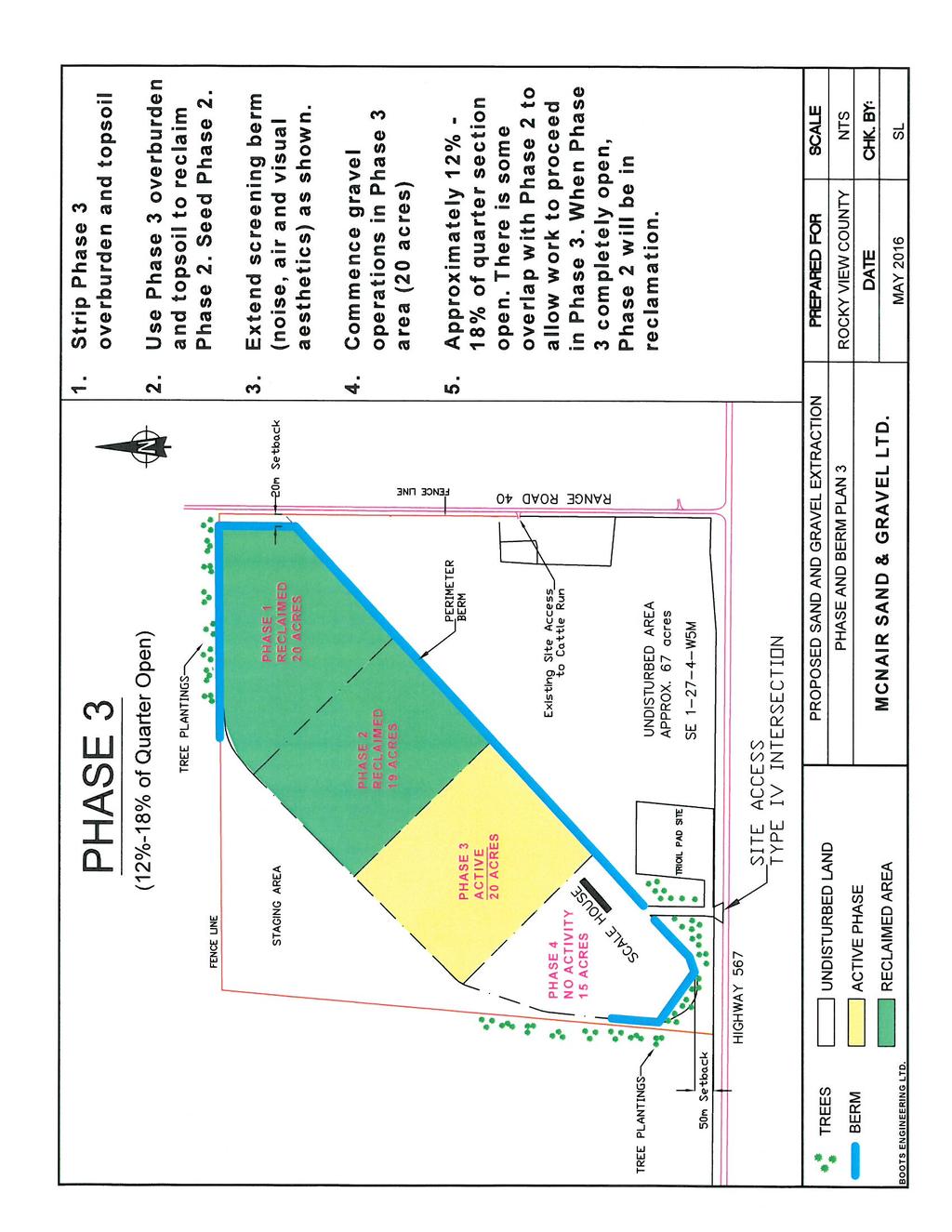
52

53
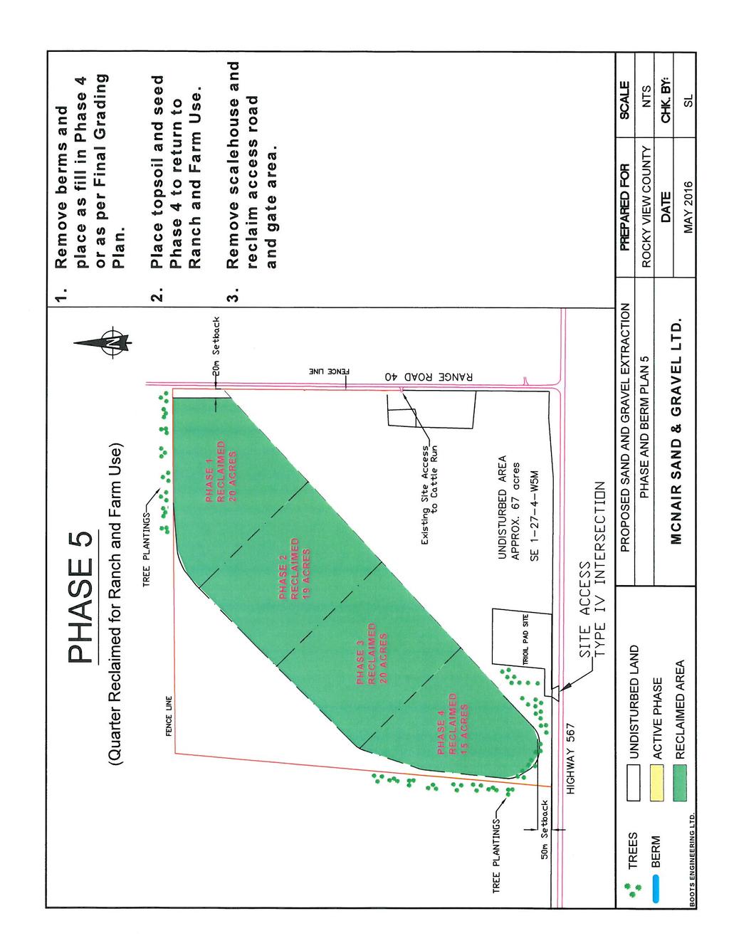
54
55
56
57
58
59
60

61
62
63

64
65
66
67
68
69
70
71
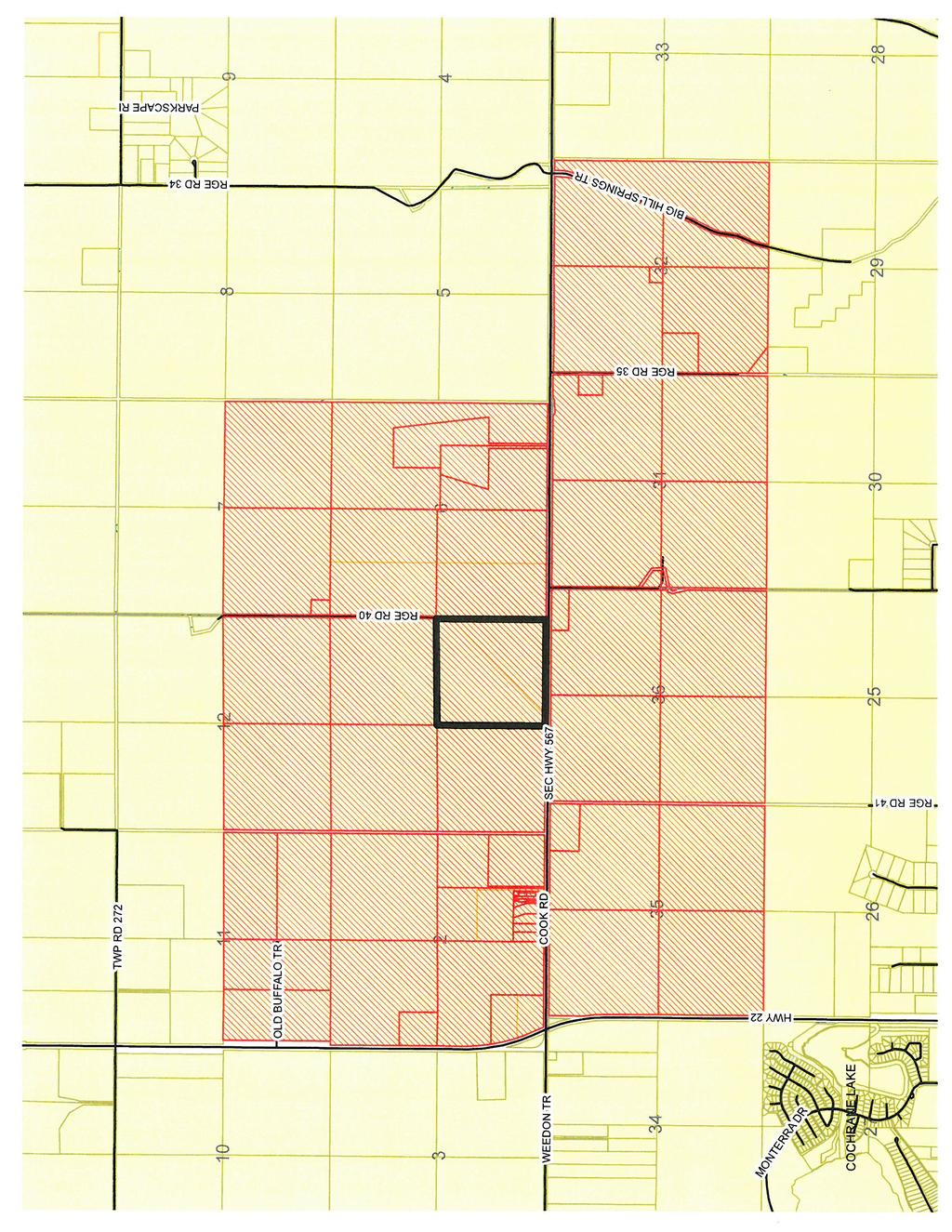
72
Master Site Development Plan
 Summit Pit Master Site Development Plan September 2017 Submitted to: Rocky View County November 2017 Submitted by: Summit Pit Master Site Development Plan Submitted to: Rocky View County Submitted by:
Master Site Development Plan BIG HILL SPRINGS GRAVEL PIT
 BIG HILL SPRINGS GRAVEL PIT Bylaw C-7226-2012 Adopted: December 11 2012 Big Hill Springs Gravel Pit Prepared in support of a proposed amendment to Bylaw C-4841-97 to redesignate the NW-36-26-4-W5M from
Nonmetallic Mining Reclamation & Operation Plan. Amendment No. 1 (Includes modifications for Wash Plant construction) DRAFT
 DRAFT") Nonmetallic Mining Reclamation & Operation Plan Amendment No. 1 (Includes modifications for Wash Plant construction) Mondovi Mine Town of Mondovi, Wisconsin Prepared for: Buffalo White Sand, LLC PO Box
Nonmetallic Mining Reclamation & Operation Plan Amendment No. 1 (Includes modifications for Wash Plant construction) Mondovi Mine Town of Mondovi, Wisconsin Prepared for: Buffalo White Sand, LLC PO Box
BEST MANAGEMENT PRACTICES PLAN FOR FUGITIVE DUST Greenwood Aggregates Company Limited Violet Hill Pit > Town of Mono, ON
 BEST MANAGEMENT PRACTICES PLAN FOR FUGITIVE DUST Greenwood Aggregates Company Limited Violet Hill Pit > Town of Mono, ON Prepared For: Greenwood Aggregates Company Limited 205467 County Road 109 Amaranth,
TES Industrial Development SW ¼ SEC Lacombe County Outline Plan
 TES Industrial Development Lacombe County Outline Plan 112849297 June 2012 am v:\1128\active\112849297\07_reports_studies\rpt_tes_20120508.doc i Table of Contents 1.0 INTRODUCTION... 1 1.1 PURPOSE... 1
ARTICLE 6 EXCAVATION OF MINERAL MATERIALS
 ARTICLE 6 EXCAVATION OF MINERAL MATERIALS SECTION 1. PURPOSE All excavations, extraction of materials and minerals, open pits and impounding of waters hereafter established or enlarged shall conform to
Reclamation Plan Modification for the Patrie Pit
 for the Patrie Pit Table of Contents Reclamation Plan Narrative.. Page 1 11 Plat Map.... Figure 1 Soils Map & Descriptions. Figure 2 Erosion Control Typical BMPs.... Figure 3 WI Construction Specification
REQUIRED INFORMATION Please check the following boxes that apply to your lot or parcel and complete the other requested information.
 MARTIN COUNTY EXCAVATION AND FILL PERMIT APPLICATION This application to be used only for excavating or filling activities not associated with a building permit or development review and for projects requiring
SECURE Energy Services Inc. Proposed Conklin Class II Landfill Portions of: NE W4, SE W4 and NW W4
 26 February 2016 RE: SECURE Energy Services Inc. Proposed Conklin Class II Landfill Portions of: NE 23-76-8W4, SE 26-76-8W4 and NW-24-76-8W4 Dear Sir or Madam, SECURE Energy Services Inc. ( SECURE ) is
Schedule A DISTRICT OF MAPLE RIDGE Watercourse Protection Bylaw
 Schedule A DISTRICT OF MAPLE RIDGE Watercourse Protection Bylaw 6410 2006 The Erosion and Sediment Control plan should seek (i) to protect the soil surface from erosion where possible and (ii) capture
H28. Special Purpose Quarry Zone
 H28. Special Purpose Quarry Zone H28.1. Zone description Mineral resources are important to Auckland s economy and development. The Special Purpose Quarry Zone provides for significant mineral extraction
PRELIMINARY DRAFT RULE LANGUAGE 8/28/2014 MNDNR SILICA SAND RECLAMATION Reclamation Plan Requirements
 PRELIMINARY DRAFT RULE LANGUAGE 8/28/2014 MNDNR SILICA SAND RECLAMATION Reclamation Plan Requirements PURPOSE OF THIS DOCUMENT: This document contains preliminary draft language related to silica sand
MOUNTAIN VIEW COUNTY BYLAW NO. 14/16 TO AMEND BYLAW NO. 15/1
 MOUNTAIN VIEW COUNTY BYLAW NO. 14/16 TO AMEND BYLAW NO. 15/1 /15 Mountain View County Province of Alberta Bylaw No. 14/16 A BYLAW OF MOUNTAIN VIEW COUNTY IN THE PROVINCE OF ALBERTA TO AMEND LAND USE BYLAW
Re: Erosion Control Report and Drawings Requirements Accompanying Document
 Re: Erosion Control Report and Drawings Requirements Accompanying Document This document was created to help engineers and other design staff to better understand, meet and exceed the erosion control requirements
D EROSION AND SEDIMENT CONTROL. Table of Contents
 Table of Contents D1. GENERAL... 1 D2. OBJECTIVE... 1 D3. REFERENCE MATERIAL... 1 D4. REGULATORY REQUIREMENTS... 1 D5. EROSION AND SEDIMENT CONTROL (ESC) PLANS... 2 D5.1 Goals and Objectives:... 2 D5.2
Chapter MINERAL EXTRACTION AND MINING OPERATIONS
 Chapter 17.31 MINERAL EXTRACTION AND MINING OPERATIONS Sections: 17.31.010 Purpose 17.31.020 Procedure for Extraction and Rehabilitation Requests 17.31.030 Operation and Rehabilitation Standards for all
RECLAMATION PLAN FOR. (name of Mine) MINING OPERATION
 MINING OPERATION") RECLAMATION PLAN FOR (name of Mine) MINING OPERATION Note: This prototype, developed by the State Mining and Geology Board (Board), is intended to assist smaller-scale mine operators in environmentally
RECLAMATION PLAN FOR (name of Mine) MINING OPERATION Note: This prototype, developed by the State Mining and Geology Board (Board), is intended to assist smaller-scale mine operators in environmentally
Construction Best Management Practices Handbook BEST MANAGEMENT PRACTICES
 Construction Best Management Practices Handbook www.montereysea.org BEST MANAGEMENT PRACTICES 26 www.montereysea.org Construction Best Management Practices Handbook VEHICLE TRACKING AND DUST CONTROL IN
CORNERSTONE RIVER VALLEY VILLAGE FILING NO. 1 STORMWATER MANAGEMENT PLAN
 CORNERSTONE RIVER VALLEY VILLAGE FILING NO. 1 STORMWATER MANAGEMENT PLAN SITUATED IN THE SW ¼ OF SECTION 18, T.2S., R.67W., OF THE 6 TH P.M. COUNTY OF ADAMS, STATE OF COLORADO PREPARED FOR: Thornton Cornerstone
DRAFT CH 10 & CH 11 October 7, 2015 From: SLDCProposedAmendmentsBCCPacket part3-1Nsm
 DRAFT CH 10 & CH 11 October 7, 2015 From: SLDCProposedAmendmentsBCCPacket10-13-2015part3-1Nsm 10.19. SMALL SCALE SAND AND GRAVEL EXTRACTION. 10.19.1. Applicability. This section applies to any mineral
Permeability across the entire site within the General Residential Zone is a minimum of 30%.
 Partly Operative District Plan Rule Assessment The following assessment is to demonstrate compliance or non-compliance with the rules of the Partly Operative District Plan. The proposed duplex dwellings,
AREA STRUCTURE PLAN SW W4M CAMROSE COUNTY BYLAW ## JULY 2017(REVISED) PREPARED BY: AUSTROM CONSULTING &VICINIA PLANNING & ENGAGEMENT INC.
 PREPARED BY: AUSTROM CONSULTING &VICINIA PLANNING & ENGAGEMENT INC.") AREA STRUCTURE PLAN SW 33-46-19-W4M CAMROSE COUNTY BYLAW ## JULY 2017(REVISED) PREPARED BY: AUSTROM CONSULTING &VICINIA PLANNING & ENGAGEMENT INC. Table of Contents 1. Purpose... 2 2. Policy Context...
AREA STRUCTURE PLAN SW 33-46-19-W4M CAMROSE COUNTY BYLAW ## JULY 2017(REVISED) PREPARED BY: AUSTROM CONSULTING &VICINIA PLANNING & ENGAGEMENT INC. Table of Contents 1. Purpose... 2 2. Policy Context...
Operating and Reclamation Plan
 Operating and Reclamation Plan For sites in sensitive locations, additional information may be required. If more space is needed, attach additional sheets or use the blank sheet provided at the end of
Gunlake Quarry. Air Quality Management Plan
 Gunlake Quarry Air Quality Management Plan August 2015 Table of Contents 1. Introduction 3 1.1 Overview 3 1.2 Aims and Objectives 3 2. Air Quality Criteria 3 2.1 Impact Assessment Criteria 4 2.2 Sources
PROJECT NARRATIVE CONDITIONAL USE REQUEST FOR C ROAD GRAVEL PIT PARKERSON CONSTRUCTION, INC.
 PROJECT NARRATIVE CONDITIONAL USE REQUEST FOR C ROAD GRAVEL PIT PARKERSON CONSTRUCTION, INC. I. INTRODUCTION- The accompanying narrative statements, maps and other attached information is provided in support
Building Better Storm Water Quality
 Building Better Storm Water Quality s Storm Water Pollution Prevention Guidelines for Development Construction Projects City of El Segundo 350 Main Street (310) 524-2380 El Segundo, California 90245 Introduction
PROVINCE OF BRITISH COLUMBIA MINISTRY OF ENERGY AND MINES
 PROVINCE OF BRITISH COLUMBIA MINISTRY OF ENERGY AND MINES SAND AND GRAVEL PERMIT APPROVING WORK SYSTEM AND RECLAMATION PROGRAM (Issued pursuant to Section 10 of the Mines Act R.S.B.C. 1996, C.293) Permit:
Report to the Montrose County Board of County Commissioners Prepared by the Montrose County Planning and Development Department #1
 Report to the Montrose County Board of County Commissioners Prepared by the Montrose County Planning and Development Department #1 PREPARED BY: MEETING DATE: SUBJECT: APPLICANT: OWNER: LOCATION: PROPOSAL:
Environmental Control Plan
 Environmental Control Plan Environmental Control Plan In accordance with Watts & Hughes Construction Waikato Bay of Plenty Limited. corporate strategies the Company has an Environment Control Plan which
Alberta Transportation The City of Edmonton The City of Calgary
 Alberta Transportation The City of Edmonton The City of Calgary PUBLISHING INFORMATION TITLE: PREPARED BY: DOCUMENT HOLDER: Environmental Construction Operations (ECO) Plan Framework Instructions for
Building Permit Applications for new home construction will not be accepted unless the following documentation is included at the time of submission:
 Building Permit Applications for new home construction will not be accepted unless the following documentation is included at the time of submission: Copy of Alberta Government s New Home Registration
SP Old Florida Investment Resources, LLC SMR Aggregates SR 64 Borrow Pit (DTS # )
") H.O. 03/24/14 SP-14-01 Old Florida Investment Resources, LLC SMR Aggregates SR 64 Borrow Pit (DTS #201400001) Request: Approval of a Special Permit for major earthmoving in the A (General Agriculture)
H.O. 03/24/14 SP-14-01 Old Florida Investment Resources, LLC SMR Aggregates SR 64 Borrow Pit (DTS #201400001) Request: Approval of a Special Permit for major earthmoving in the A (General Agriculture)
NEWNES JUNCTION SAND AND KAOLIN EXTRACTION PROJECT
 SYDNEY CONSTRUCTION MATERIALS NEWNES JUNCTION SAND AND KAOLIN EXTRACTION PROJECT QUARRY PLAN MineConsult mine management consultants May, 2004 Job No. 1864 CONFIDENTIALITY AND USE OF INTELLECTUAL PROPERTY
Appendix 4. Soil Management Plan
 Appendix 4 Soil Management Plan Soil Management Plan This Soil Management Plan (SMP) has been developed for the Giscome Quarry and Lime Plant Project. The SMP is a living document and will be updated as
Jeremy s Construction Ltd.
 Jeremy s Construction Ltd. Environmental Assessment Registration Document Proposed Doyles Quarry Extension Submitted by: Jeremy s Construction Limited P.O. Box 137 Doyles, NL A0N 1J0 March 2017 Table of
Guidance for Filling Out An Application for an Earth Moving Permit / Dust Control Plan. Section 1 Applicant Information
 Guidance for Filling Out An Application for an Earth Moving Permit / Dust Control Plan The Application for an Earth Moving Permit / Dust Control Plan Is At the End of This Guidance Section 1 Applicant
GRADING, EROSION AND SEDIMENTATION CONTROL
 SECTION 500 GRADING, EROSION AND SEDIMENTATION CONTROL 501 Erosion and Sedimentation Control Plan All engineering plans for projects that propose to construct new, or modify existing drainage facilities,
VISUAL SITE INSPECTION REPORT 2018
 VISUAL SITE INSPECTION REPORT 2018 SOUTHERN INDIANA GAS AND ELECTRIC A. B. BROWN GENERATING STATION TYPE III RESTRICTED WASTE LANDFILL WEST FRANKLIN, IN ATC PROJECT NO. 170LF00614 January 9, 2019 PREPARED
CCSD#1 Stormwater Standards
 SECTION 6 EROSION CONTROL STANDARDS 6.1 INTRODUCTION The policies of this section shall apply during construction and until permanent measures are in place following construction as described herein, unless
CEAA ENVIRONMENTAL ENVIRONMENTAL IMPACT ASSESSMENT AMBASSADOR BRIDGE ENHANCEMENT PROJECT. Replacement Span and Plaza Expansion APPENDIX E
 Ambassador Bridge Enhancement Project CEAA ENVIRONMENTAL ENVIRONMENTAL IMPACT ASSESSMENT AMBASSADOR BRIDGE ENHANCEMENT PROJECT Replacement Span and Plaza Expansion APPENDIX E DRAFT EROSION AND SEDIMENT
Papua New Guinea LNG Project. Environmental and Social Management Plan Appendix 11: Reinstatement Management Plan PGGP-EH-SPENV
 Esso Highlands Limited Papua New Guinea LNG Project Environmental and Social Management Plan Appendix 11: PGGP-EH-SPENV-000018-013 LNG Project Page 2 of 13 CONTENTS 1.0 Objectives... 3 2.0 Legal and Other
Environmental Assessment Approval
 Environmental Assessment Approval Approval Date: Original Dated April 20, 2012 Trimper Sand and Gravel Pit Expansion Ivan H. Trimper Construction Ltd., Proponent Annapolis County, Nova Scotia The Trimper
BUMSTEAD PIT. Part Lot 27, Concession 7 Geographic Township of Holland Township of Chatsworth County of Grey
 BUMSTEAD PIT Applications to Amend the County of Grey Official Plan and Township of Chatsworth Zoning By-law to facilitate an Application for a Class A, Category 1 License for Mineral Resource Extraction
Guidance for Filling Out An Application for an Earth Moving Permit / Dust Control Plan. Section 1 Applicant Information
 Guidance for Filling Out An Application for an Earth Moving Permit / Dust Control Plan The Application for an Earth Moving Permit / Dust Control Plan Is At the End of This Guidance Section 1 Applicant
Planning and Zoning Staff Report Triple Crown Development, CU
 Applicant: Triple Crown Development, LLC Representative: Dave Cockrum 208-283-2100 Staff: Deb Root droot@canyonco.org Tax ID, Acres: R36078 (80.97 acres) Current Zone: A (Agriculture) Hearing Date: November
Barr Road Quarry (Site N) Frequently Asked Questions Last updated: November 19, 2007
 Frequently Asked Questions Last updated: November 19, 2007") Barr Road Quarry (Site N) Frequently Asked Questions Last updated: November 19, 2007 1. Why site a quarry in the Cline Buttes Area? The Cline Buttes area is proximate to several highways, OR 126, US 97
Barr Road Quarry (Site N) Frequently Asked Questions Last updated: November 19, 2007 1. Why site a quarry in the Cline Buttes Area? The Cline Buttes area is proximate to several highways, OR 126, US 97
Environmental Management Chapter ALABAMA DEPARTMENT OF ENVIRONMENTAL MANAGEMENT WATER DIVISION - WATER QUALITY PROGRAM ADMINISTRATIVE CODE
 Environmental Management Chapter 335-6-9 ALABAMA DEPARTMENT OF ENVIRONMENTAL MANAGEMENT WATER DIVISION - WATER QUALITY PROGRAM ADMINISTRATIVE CODE CHAPTER 335-6-9 SURFACE MINING RULES TABLE OF CONTENTS
SECTION 11 PART I STORMWATER QUALITY PROTECTION Definitions / Acronyms 11-3 PART 1 CONSTRUCTION PRACTICES
 SECTION 11 PART I STORMWATER QUALITY PROTECTION CONTENTS Page 11-1 Definitions / Acronyms 11-3 PART 1 CONSTRUCTION PRACTICES 11-2 Stormwater Pollution Prevention Plan (SWPPP) 11-3 11-3 Erosion and Sediment
West Village, 70 Mississauga Road South, Mississauga. Construction Management Plan Phase I: Demolition & Remediation
 West Village, 70 Mississauga Road South, Mississauga Construction Management Plan Phase I: Demolition & Remediation FINAL, revision 1 January 26, 2018 Table of Contents 1.0 INTRODUCTION... 2 2.0 HOARDING
Washington County Landfill Reconstruction Project: Progress Updates
 Home Site Index Glossary What's New Ask MPCA Visitor Center MPCA Home > Clean Up > Perfluorochemicals > Perfluorochemical (PFC) Waste Sites > Washington County Site Progress Updates Washington County Landfill
ADMINISTRATION OF AGGREGATE SOURCES INCLUDING EARTH AND ROCK BORROW SOURCES. Special Provision No. 199S38 March 2003
 ADMINISTRATION OF AGGREGATE SOURCES INCLUDING EARTH AND ROCK BORROW SOURCES Special Provision No. 199S38 March 2003 The following MTO specification is not based on or referenced to an OPS Specification.
Site-Specific PM 10 Ambient Air Monitoring Plan
 Site-Specific PM 10 Ambient Air Monitoring Plan Great Plains Sand Processing Facility Wenck File #2771-01 Prepared for: GREAT PLAINS SAND, LLC 15870 Johnson Memorial Drive Jordan, MN 55352 February 2012
Background. Overview: Rail Yard Expansion. NOVA Chemicals Joffre Site Project Description: Proposed Rail Yard Expansion
 NOVA Chemicals Joffre Site Project Description: Proposed Rail Yard Expansion Accompanying the Application to Lacombe County for Rezoning and a Development Permit January Background In mid-2012, Lacombe
Elmer s Crane and Dozer, Inc.
 Elmer s Crane and Dozer, Inc. 4281 Pickerel Lake, Petoskey, MI Emmet County Planning Commission Presentation for a Level III Special Use Permit for Resource Mining Elmer s Crane and Dozer, Inc. Family
LETHBRIDGE WASTE AND RECYCLING CENTRE PROJECT SUMMARY
 LETHBRIDGE WASTE AND RECYCLING CENTRE PROJECT SUMMARY 1.1 Location and Site Description The Lethbridge Waste and Recycling Centre is located approximately in the SW ¼ 4-10-21-W4. The proposed expansion
ROBINSON TOWNSHIP th Avenue, Grand Haven, Michigan
 ROBINSON TOWNSHIP 12010-120 th Avenue, Grand Haven, Michigan 49417 616-846-2210 REQUEST FOR EARTH CHANGE - CLASS A REQUEST FEE: $150.00 + ESCROW FEE MINIMUM OF $300.00 (Escrow fees cover additional Township
APPENDIX I DUST SUPPRESSION/CONTROL PLAN
 APPENDIX I DUST SUPPRESSION/CONTROL PLAN SENECA MEADOWS SOLID WASTE MANAGEMENT FACILITY APPENDIX I DUST SUPPRESSION/CONTROL PLAN MEADOW VIEW SURFACE MINE PREPARED FOR SENECA MEADOWS, INC. 1786 SALCMAN
STAFF REPORT TOMMER SHORT TERM MINERAL EXTRACTION
 STAFF REPORT TOMMER SHORT TERM MINERAL EXTRACTION TO: Douglas County Hearing Examiner FROM: Douglas County Land Services Staff RE: Tommer, CUP-2017-05 DATE: August 16, 2018 I. GENERAL INFORMATION Requested
Independent Expert Engineering Investigation and Review Panel. Report on Mount Polley Tailings Storage Facility Breach. Appendix G: Water Balance
 Independent Expert Engineering Investigation and Review Panel Report on Mount Polley Tailings Storage Facility Breach Appendix G: Water Balance January 30, 2015 Report on Mount Polley Tailings Storage
Q. CONSTRUCTION IMPACTS
 Q. CONSTRUCTION IMPACTS 1. Construction Plan As noted on Exhibit 3Q-1, Overall Phasing Plan and SWPPP Notes, construction of the Proposed Project is anticipated to include five phases. The entire construction
Table E-1 SUMMARY OF DESIGN CHANGES AND MITIGATIONS Meadow View Surface Mine Waterloo, New York
 TABLES Table E-1 SUMMARY OF DESIGN CHANGES AND MITIGATIONS Description of Design Change or Mitigation Design (D) change or Mitigation (M) Section 6-foot-tall vegetated screening berm along Burgess Road,
This summary and the Report subsequently inform the recommended mitigation contained in Section 28 and will inform the Project conditions.
 18. Air The Project Air quality team prepared an Air Quality Assessment Report for the Project, which is included in Volume 3 (Part 1). The Report provides an assessment of air quality effects associated
Borrow Pit and Quarry Management Procedure Environmental
 1 Purpose and Scope This procedure specifies the operational environmental requirements relating to borrow pit (BP) and quarry management at the Roy Hill Project. This procedure applies to all personnel
Application to the ALC for a Non-Farm Use in the ALR for gravel extraction
 REPORT TO COUNCIL Date: April 11, 2016 RIM No. 1210-10 To: City Manager From: Community Planning Department (MS) Application: A15-0008 Owner: L.H. Turton F.T. Turton Address: 3110 Mathews Road Applicant:
Refer to Chapter 3.0 (Description of Development) for a detailed site and development description.
 for a detailed site and development description.") 7. WATER: HYDROGEOLOGY & HYDROLOGY 7.1 Introduction This chapter of the EIAR comprises of an assessment of the likely impact of the proposed development on the surrounding surface water and hydrogeological
7. WATER: HYDROGEOLOGY & HYDROLOGY 7.1 Introduction This chapter of the EIAR comprises of an assessment of the likely impact of the proposed development on the surrounding surface water and hydrogeological
Draft Dust Management Plan
 Draft Dust Management Plan December 2017 Mt Messenger Alliance MMA-ENV-AIR-RPT-1032 Quality Assurance Statement Prepared by: Dylan Vernall, Sharon Atkins Tonkin and Taylor Ltd Reviewed by: Jenny Simpson
Targeted Constituents Sediment Nutrients Trash Metals Bacteria Oil and Grease Organics. Potential Alternatives. EC-5 Soil Binders
 Categories EC Erosion Control SE Sediment Control TC Tracking Control WE Wind Erosion Control Non-Stormwater NS Management Control Waste Management and WM Materials Pollution Control Legend: Primary Category
Yorkton Rona Commercial and Industrial development. Concept Plan and Serviceability Report
 Yorkton Rona Commercial and Industrial development Concept Plan and Serviceability Report Prepared for: 101242326 Sask Ltd. Box Ft Quappelle, SK Canada S0G 1S0 Prepared by: Stantec Consulting Ltd. 302-1345
Town of Friday Harbor PO Box 219 / Friday Harbor / WA / (360) / fax (360) /
 / fax (360) /") Town of Friday Harbor PO Box 219 / Friday Harbor / WA / 98250 (360) 378-2810 / fax (360) 378-5339 / www.fridayharbor.org LAND CLEARING, GRADING, OR FILLING PERMIT APPLICATION APPLICATION DATE GRD No. APPLICANT/FRANCHISE
Town of Friday Harbor PO Box 219 / Friday Harbor / WA / 98250 (360) 378-2810 / fax (360) 378-5339 / www.fridayharbor.org LAND CLEARING, GRADING, OR FILLING PERMIT APPLICATION APPLICATION DATE GRD No. APPLICANT/FRANCHISE
THIS PAGE LEFT BLANK FOR TWO-SIDED DUPLICATION.
 PROJECT DESCRIPTION THIS PAGE LEFT BLANK FOR TWO-SIDED DUPLICATION. Table of Contents Article 4.203.B.5 Project Description... 1 Facility Operations... 2 Construction:... 2 Drilling and Completions Phases:...
PLANNED UNIT DEVELOPMENT & PLANNING APPROVAL STAFF REPORT Date: February 7, 2013
 PLANNED UNIT DEVELOPMENT & PLANNING APPROVAL STAFF REPORT Date: February 7, 2013 NAME LOCATION MAWSS Shelton Beach Road East side of Shelton Beach Road Extension, 2/10± mile North of Moffett Road CITY
Order of road works and servicing construction to be carried out in accordance with the staged contract construction sequence specified below.
 SEDIMENT CONTROL NOTES 1.0 GENERAL 1.1 The Developer and Contractor shall comply with the requirements of all regulatory authorities, federal, provincial and municipal government departments including
SECTION 4.0 ALTERNATIVES
 SECTION 4.0 ALTERNATIVES 4.1 CEQA REQUIREMENTS The key requirements under the California Environmental Quality Act (CEQA) to identify and evaluate alternatives in an Environmental Impact Report (EIR) are
Typical Local Erosion Control Requirements (Storm Water Management Authority, Inc.)
") Module 2: Selection of Controls and Site Planning for Construction Site Erosion Prevention Robert Pitt Department of Civil, Construction, and Environmental Engineering University of Alabama Tuscaloosa,
Module 2: Selection of Controls and Site Planning for Construction Site Erosion Prevention Robert Pitt Department of Civil, Construction, and Environmental Engineering University of Alabama Tuscaloosa,
Erosion & Sedimentation Control Policy
 Issue Date 10/22/2010 Page 1 of 8 Erosion & Sedimentation Control Policy Introduction: Soil erosion is the removal of soil by water, wind, ice or gravity and sediment deposition occurs when the rate of
Conservation and Reclamation INFORMATION LETTER. Environmental Protection Guidelines for Oil Production Sites - Revised January 2002
 March 2002 Conservation and Reclamation INFORMATION LETTER C&R/IL/02-1 Environmental Protection Guidelines for Oil Production Sites - Revised January 2002 CHANGES TO THE INFORMATION LETTER This Information
Highland Gate Developments Inc. (SUB ) Construction Impact Mitigation Plan No. 1 (Phase 1 Site Alteration Works) February 2017.
 Construction Impact Mitigation Plan No. 1 (Phase 1 Site Alteration Works) February 2017.") Highland Gate Developments Inc. (SUB-2015-01) Construction Impact Mitigation Plan No. 1 (Phase 1 Site Alteration Works) February 2017 Submitted by: SCS Consulting Group Ltd 30 Centurian Drive, Suite 100
Highland Gate Developments Inc. (SUB-2015-01) Construction Impact Mitigation Plan No. 1 (Phase 1 Site Alteration Works) February 2017 Submitted by: SCS Consulting Group Ltd 30 Centurian Drive, Suite 100
ZONING CLEARANCE PLAN REVIEW CHECKLIST. Based on the Revised Town of Carefree Zoning Ordinance
 ZONING CLEARANCE PLAN REVIEW CHECKLIST Based on the Revised Town of Carefree Zoning Ordinance Date: Applicant: Permit Number: Reviewer: Address: Lot & Subdivision: Zoning District: New SRF: Addn/Remodel:
TRAFFIC MANAGEMENT PLAN REQUIREMENTS FOR COMMERCIAL/LARGE DEVELOPMENT SITES
 TRAFFIC MANAGEMENT PLAN REQUIREMENTS FOR COMMERCIAL/LARGE DEVELOPMENT SITES The District of West Vancouver requires a Traffic Management Plan (TMP) to be submitted for acceptance by the Land Development
PART II - CODE OF ORDINANCES Chapter 16 - CONSTRUCTION, REHABILITATION AND PROPERTY MAINTENANCE REGULATIONS ARTICLE VIII. PROPERTY MAINTENANCE
 Sec. 16-291. Construction site management. (a) Construction site management plan required. No building permit shall be issued unless a construction site management plan has been submitted and approved
Managing Salt Impacted Water at Maintenance Yards
 Managing Salt Impacted Water at Maintenance Yards Presented to the: Transportation Association of Canada Calgary 2005 Abstract Managing Salt Impacted Water at Maintenance Yards The Code of Practice for
Proposed District Plan Change 83: Kiwi Point Quarry. Plan Change Document: Alterations to the Wellington City District Plan
 Proposed District Plan Change 83: Kiwi Point Quarry Plan Change Document: Alterations to the Wellington City District Plan Kiwi Point Quarry Plan Change 83 Provisions Annotated provisions of Chapters 33
FEDERAL ENERGY REGULATORY COMMISSION FIELD INSPECTION REPORT
 FIELD INSPECTION REPORT Date May 22, 2018 Project Northern Natural Gas Company Cedar Station Upgrade Project Dakota County, Minnesota Authority: Sections 7(c) Personnel FERC Staff: Company Staff: S. Xiah
3.0 Natural Resource Management Policies. 3.4 Resource Extraction Policies
 3.0 Natural Resource Management Policies 3.4.1 Mineral Aggregates INTRODUCTION Oxford County is characterized by significant reserves of mineral aggregates, including bedrock-derived crushed stone and
Code of Practice for Exploration Operations
 Code of Practice for Exploration Operations September 2005 Made under the Environmental Protection and Enhancement Act Published by Alberta Queen s Printer Alberta Queen s Printer Suite 700, Park Plaza
Larimer County Land Use Code Section 5.8: Rural Land Use Process
 Larimer County Land Use Code Section 5.8: Rural Land Use Process 5.8.6 PRINCIPLES D. Development Standards 3. Engineering Standards and Guidelines for Roads and Drainage The following Standards and Guidelines
New Administration Building
 New Administration Building Stormwater Pollution Prevention Plan Hudson Valley Community College Troy, New York Prepared for: Hudson Valley Community College 80 Vandenburgh Avenue Troy, New York 12180
MIXED ACTIVITY ZONE. Chapter 4. Mixed Activity Zone
 Chapter 4 Mixed Activity Zone 4. MIXED ACTIVITY ZONE 4.1 RESOURCE MANAGEMENT ISSUES 1. Activities adjoining main arterial roads can adversely affect the safety, sustainability and efficiency of the network.
MATRIX 1: ENVIRONMENTAL MANAGEMENT PLAN TO BE IMPLEMENTED DURING THE SITE PREPARATION AND CONSTRUCTION PHASES
 MATRIX 1: ENVIRONMENTAL MANAGEMENT PLAN TO BE IMPLEMENTED DURING THE SITE PREPARATION AND CONSTRUCTION PHASES Environmental / Social issue/ aspect/ activity Anticipated negative impact Management and mitigation
STORM WATER POLLUTION PREVENTION PROGRAM SAILOR BAR/ CUTTERS PIT SATELLITE STORAGE YARD
 COUNTY OF SACRAMENTO Public Works Agency Department of Transportation STORM WATER POLLUTION PREVENTION PROGRAM SAILOR BAR/ CUTTERS PIT SATELLITE STORAGE YARD SACRAMENTO COUNTY DEPARTMENT OF TRANSPORTATION
Kobe Pumping Plant and Pipeline Project Narrative UPDATED 6/28/13
 Kobe Pumping Plant and Pipeline Project Narrative UPDATED 6/28/13 Introduction/Background The Kobe Pumping Plant and Pipeline (the Project ) is located in Mesa and Garfield Counties near DeBeque, Colorado.
Aggregate, Landscapes and Watersheds: A Brief Overview
 Aggregate, Landscapes and Watersheds: A Brief Overview presented by Judy Stewart, LL.M. (PhD Candidate) CEAC Aggregate Exploration and Extraction Policy Workshop Cochrane Ranchehouse May 25, 2015 Aggregate
Works, services and infrastructure code
 9.4.11 Works, services infrastructure code 9.4.11.1 Application (1) This code applies to assessable development identified as requiring assessment against the Works, services infrastructure code by the
MINNEHAHA CREEK WATERSHED DISTRICT BOARD OF MANAGERS REVISIONS PURSUANT TO MINNESOTA STATUTES 103D.341. Adopted April 24, 2014 Effective June 6, 2014
 MINNEHAHA CREEK WATERSHED DISTRICT BOARD OF MANAGERS REVISIONS PURSUANT TO MINNESOTA STATUTES 103D.341 Adopted April 24, 2014 Effective June 6, 2014 EROSION CONTROL RULE 1. POLICY. It is the policy of
Lignite Mining and Reclamation Process. Kayla Torgerson The Coteau Properties Co.
 Lignite Mining and Reclamation Process Kayla Torgerson The Coteau Properties Co. 1 Presentation Overview History of Regulation The Process of Mining and Reclamation Harmony Lake 2 1 2 3 4 5 6 7 8 Which
APPROVED FOR ISSUANCE REFER TO ENCROACHMENT AND/OR CONSTRUCTION PERMIT AND PLAN COVER SHEET FOR SPECIAL CONDITIONS AND PERMIT NUMBERING
 APPROVED FOR ISSUANCE REFER TO ENCROACHMENT AND/OR CONSTRUCTION PERMIT AND PLAN COVER FOR SPECIAL CONDITIONS AND PERMIT NUMBERING GENERAL NOTES: HOUSE GREEN HOUSE 1900 S. NORFOLK ST. SUITE 350 GARAGE GRADING
MINUTES OF THE MUNICIPAL PLANNING COMMISSION Tuesday, September 23, 2008 Red Deer County Council Chambers, Red Deer County Centre
 MINUTES OF THE MUNICIPAL PLANNING COMMISSION Tuesday, September 23, 2008 Red Deer County Council Chambers, Red Deer County Centre Present: Absent: Chairman Councillor R. Poth, Councillors P.T. Archibald,
Traffic Management Plan. Environmental Management and Monitoring Program. Appendix VI
 Traffic Management Plan Environmental Management and Monitoring Program Appendix VI Gunlake Quarries December 2009 Olsen Consulting Group Pty Ltd 6/25 Victoria Street WOLLONGONG 2500 PO Box 353 FIGTREE
181 State Road 415, New Smyrna Beach. Railey Harding & Allen, P.A. Barcelo Developments, Inc. Scott Ashley, AICP, Planning Manager
 GROWTH AND RESOURCE MANAGEMENT DEPARTMENT PLANNING AND DEVELOPMENT SERVICES DIVISION CURRENT PLANNING ACTIVITY 123 W. Indiana Avenue, Room 202, DeLand, FL 32720 (386) 943-7059 PUBLIC HEARING: CASE NO:
Guidance for Filling Out An Application for an Earth Moving Permit / Dust Control Plan. Section 1 Applicant Information
 Guidance for Filling Out An Application for an Earth Moving Permit / Dust Control Plan The Application for an Earth Moving Permit / Dust Control Plan Is At the End of This Guidance Section 1 Applicant