SEMMMS A6 - M60 RELIEF ROAD
|
|
|
- Kelly Reeves
- 6 years ago
- Views:
Transcription


1 SEMMMS A6 - M60 RELIEF ROAD FEASIBILITY STUDY VOLUME 1: STAGE 1 STUDY REPORT Report N o : 1

2 SEMMMS A6 - M60 RELIEF ROAD STUDY STAGE 1 STUDY VOLUME 1 STUDY REPORT Transport for Greater Manchester & Stockport Metropolitan Borough Council Click here to enter text. Project no: The Victoria The Quays Salford Greater Manchester M50 3SP
3
4 ii TABLE OF CONTENTS 1 EXECUTIVE SUMMARY OVERVIEW POLICY REVIEW ECONOMIC CONTEXT TRAFFIC AND TRAFFIC DATA REVIEW WIDER CONSIDERATIONS HIGHWAY DESIGN AND OPTIONS REVIEW ENVIRONMENTAL REVIEW STAGE 1 SUMMARY AND CONCLUSIONS INTRODUCTION BACKGROUND AND CONTEXT STUDY BRIEF WIDER CONSIDERATIONS SCHEME LOCATION AND DESCRIPTION THE TRAFFIC CASE FOR THE A6 M60 SCHEME SCHEME INFRASTRUCTURE REPORT STRUCTURE TRANSPORT POLICY REVIEW INTRODUCTION NATIONAL TRANSPORT POLICIES REGIONAL TRANSPORT POLICIES GREATER MANCHESTER TRANSPORT POLICIES GREATER MANCHESTER SPATIAL FRAMEWORK SUMMARY AND CONCLUSIONS ECONOMIC REVIEW INTRODUCTION NORTH OF ENGLAND NORTH WEST ENGLAND GREATER MANCHESTER LOCAL TRENDS SUMMARY AND CONCLUSIONS TRAFFIC & TRAVEL DATA REVIEW INTRODUCTION THE TRAFFIC CASE FOR THE A6-M60 SCHEME Stage 1 Report
5 iii 5.3 ROAD TRAFFIC CONGESTION THE ORIGINAL SEMMMS TRAFFIC MODELS OUTLINE BUSINESS CASE A6MARR PLANNING APPLICATION PREVIOUS DATA COLLECTION FURTHER DATA REQUIREMENTS SUMMARY AND CONCLUSIONS HIGHWAY DESIGN OPTIONS REVIEW INTRODUCTION TASK OBJECTIVES CONCLUSION AND RECOMMENDATIONS ENVIRONMENTAL REVIEW INTRODUCTION SCOPE AND CONTEXT SUMMARY OF PREVIOUS ENVIRONMENTAL ASSESSMENTS POLICIES AND PLANS DISRUPTION DUE TO CONSTRUCTION CUMULATIVE EFFECTS KEY CONSTRAINTS ASSOCIATED WITH THE EXISTING INFORMATION NEXT STEPS SUMMARY AND CONCLUSIONS STAGE 1 SUMMARY AND CONCLUSIONS SUMMARY CONCLUSIONS RECOMMENDATIONS Stage 1 Report
6 iv FIGURES Figure 2-1: A6 - M60 Relief Road Northern Section Figure 2-2: A6 - M60 Relief Road Southern Section Figure 2-3: Scheme in Wider Context Figure 3-1: Extracted from GM Transport Strategy Figure 3-2: Main Commuting Flows Figure 3-3: The Proposed Key Route Network Figure 4-1 Local Authority Boundaries Figure 4-2 Percentage Increase in Population (2013 To 2033) Figure 4-3 Percentage Increase in Housing Based on 2008 Data (2013 to 2033) Figure 4-4 Percentage in Housing Based on 2012 Data (2013 to 2033) Figure 4-5 Summary of Local Trends Figure 4-6 Land Uses within Stockport MBC Figure 4-7 Main Commuting Flows Figure 5-1 Areas of Significant Congestion and Delay Figure 5-2 Change in Total Traffic on Major Roads Figure Morning Peak Hour Observed Vehicle Speeds Figure 5-4 Stockport Morning Peak (08:00-09:00) Average Speed By Link September 2013-August Figure 5-5 Stockport Off-Peak (10:00-16:00) Average Speed By Link September August Figure 5-6 Stockport Evening Peak (17:00-18:00) Average Speed By Link September 2013-August Figure 5-7 Stockport and GN Journey Time Profile 2011/12 For A & B; Roads Figure 5-8 Average Journey Times (Flow-Weighted) During the Weekday Morning Peak on Locally Managed 'A' Roads: Annually From 2006/ Figure 5-9 Main Commuting Flows Figure 5-10 Routing of Westbound Traffic on the A AM Peak Figure 5-11 Road Injury Accidents in Stockport Figure 5-12 Child and Adult Killed and Seriously Injured Road Accidents in Stockport Figure 5-13 Child and Adult Pedestrian Road Injury Accidents in Stockport Figure 7-1 Environment Agency Flood Map Figure 7-2 Strategic Transport Corridor (ST2) Figure 7-3 Sites Of Biological Importance, Strategic Open Space And Strategic Recreation Routes Figure 7-4 Conservation Areas (Hc1) And Employment Areas Figure 7-5 Flood Risk Zones Figure 7-6 Green Belt (Gba1), Green Belt Meds And Green Chains (Ne3) Figure 7-7 Metrolink Corridor And M60 Gateway Sites Figure 7-8 Local Nature Reserves, Local Open Space And Local Wildlife Sites Stage 1 Report
7 v TABLES Table 3-1: Summary of Relevant TfGM Ambitions Table 3-2: Cheshire East Council Table 3-3: Stockport MBC Table 4-1 Comparison of Population Growth Table 4-2 Forecast Housing Growth Based on 2008 Data ( ) Table 4-3 Forecast Housing Growth Based on 2012 Data ( ) Table 4-4 Household Projections based on relevant Planning Policy Table 4-5 Future Employment Forecasts ( ) Table 4-6 Gross Value Added (GVA) Increase per Annum59 Table 4-7 Percentage Increase in Traffic (Taken from A6 MARR Forecasting Report) Table 7-1 : Comparison of Environmental Topics Between The 2003 Environmental Assessment and Ian125/15 (October 2015) Table 7-2 Provisional Schedule Of Listed Buildings APPENDICES The following appendices are included in Volume 2. Appendix 1 Study Brief Appendix 2 Supporting Transport Statistics Appendix 3 The Greater Manchester Transport Strategy 2040: Our Vision Ref Amber Green Assessment Appendix 4 Local Major Funding Bid Letters Of Support Appendix 5 Data Collection Specification Report Appendix 6 Existing Mainline Drawings Appendix 7 Geometric Design Checks Appendix 8 A6-Manchester Airport Relief Road Drawing Appendix 9 Land Ownership Plan Appendix 10 Environmental Constraints Plan Stage 1 Report
8 6 1 EXECUTIVE SUMMARY 1.1 OVERVIEW In 2000 to 2001, the Government of the time undertook a thorough multi-modal study into the travel and traffic issues facing the South East quadrant of Greater Manchester, in partnership with Stockport MBC, Tameside MBC, Manchester CC, Cheshire County Council (as was) and GMPTE. The South East Manchester Multi Modal Strategy (SEMMMS) reported in September It recommended a multi modal programme for delivery to 2021 including, in particular, three highway schemes that were remitted to the study, as follows: A road between the M60 at Bredbury and the A6 at Hazel Grove, following the protected alignment for the A6(M). The construction of the Stepping Hill Link between the A6 north of Hazel Grove centre and the new road forms part of the recommendation. It is recommended that the north-south bypass be constructed to dual carriageway standard with a 40/50 mph design speed. Junctions should be at grade and most likely signal controlled; A bypass of Poynton is constructed. The bypass should comprise an east-west section linking the A555/A5102 junction north of Woodford to the A6 at Hazel Grove. Traffic modelling undertaken for the study indicates that a dual carriageway is more than likely required, but junctions can be accommodated at grade. For the north-south bypass of the A523 a single carriageway bypass is recommended from the existing A523 at Adlington, joining the eastwest section of the bypass north of Woodford; and A reduced scale scheme is constructed in the MALRW corridor. Traffic modelling indicates that an at-grade dual carriageway linking the Airport roundabout at the end of the M56 spur to the western end of the A555 at Handforth is sufficient. An at-grade junction at Styal Road should be provided. Combined with other recommendations, there is the opportunity to introduce dedicated HGV/public transport lanes along the MALRW corridor Since then, a programme of work has been undertaken, supported by funding from a range of sources, including the Greater Manchester Transport Fund and Local Transport Plan. In particular, the MALRW proposal now subsumed into the A6-Manchester Airport Relief Road (A6MARR) Scheme - has been supported through the GM Transport Fund and is now being delivered, and Cheshire East has prioritised the Poynton Bypass scheme The A6 to M60 scheme is thus the final highway component of the SEMMMS strategy which has delivered benefits to local communities across south east Manchester through a range of new highway infrastructure, public transport and sustainable transport measures over the past 15 years. Scheme Description and Context The A6 to M60 Relief Road Scheme will provide 8.5 km of new 2-lane 50mph dual carriageway on an north - south route from the M60 Junction 25 at Bredbury (north east of Stockport) to the A6 near Hazel Grove (south east Stockport). It will also provide a link road to Stepping Hill of 1.1km allowing improved access to Stepping Hill Hospital. Stockport Metropolitan Borough Council Project No Stage 1 Report
9 The proposed scheme will allow road traffic to bypass the heavily congested routes to the M60 that presently pass through Hazel Grove, Stockport town centre, Offerton and Bredbury in both directions also bypassing local districts and centres. It will provide much needed connectivity for key strategic routes into the North, the North West, and the wider Greater Manchester conurbation and specifically to Manchester Airport; including traffic from the A6, A523 and A34 all of which are key routes for business, leisure, travel and freight The scheme will also provide additional connectivity to the proposed Trans-Pennine Tunnel route which, if constructed, will run under the Peak District from the Sheffield region to Greater Manchester and enhance the transport resilience between these two city regions The completed A6MARR scheme will also bypass and alleviate congestion in Bramhall, Cheadle Hulme, Handforth, Poynton, Wythenshawe, Gatley and Heald Green. Study Brief In the March 2015 Budget Statement, the Government granted 350,000 to the GM Combined Authority to undertake a contemporary review of the case for the A6-M60 Relief Road i.e. the road scheme summarised in (a) above (the former A6M and Stepping Hill Link Road which became part of the SEMMMS Relief Road) The review was split into two stages: Stage 1, the subject of this report, is to undertake a review the previous outline business case with attention paid to current policy, economic context, contemporary travel and traffic data, highway design options and environmental review Stage 2 of the review is to prepare a webtag-compliant outline business case for the A6-M60 relief road. 1.2 POLICY REVIEW The policy review has examined the scheme in the context of national, regional and local transport policies. The scheme forms part of the wider South East Manchester Multi-Modal Strategy (SEMMMS) and will complement two other road schemes, the new A6MARR which is under construction and the Poynton Relief Road which is progressing towards a planning application, with start of construction expected in The review has shown that the proposed A6-M60 scheme aligns with national policy as follows: There is a large forecast increase in traffic on the Strategic Road Network (SRN) which has to access the SRN via local roads and this necessitates improved infrastructure connecting with the SRN. In recognition of this, Highways England is prepared to invest in local road infrastructure improvements that help the SRN. The scheme would support the Government's Freight Policy by providing a congestion free route between Manchester Airport and Stockport. The scheme would also support the delivery of HS2 by improving connectivity to the proposed HS2 station at Manchester Airport. The fact that this current study has been requested by the Government provides a strong indicator that the A6-M60 scheme is consistent with National Transport Policy The proposed A6-M60 scheme aligns with regional policy as follows: The scheme will support regional growth by providing additional capacity on the transport network and improving journeys times. Journey times across the transport network in the north were identified as a key issue by Transport for the North. Stockport Metropolitan Borough Council Project No Stage 1 Report
10 8 Access to Manchester Airport and also improved connectivity for freight is identified as a key driver of the Northern Powerhouse. The scheme will provide improved connectivity to Manchester Airport and will also provide a congestion free freight route The A6-M60 scheme aligns with local policy as follows: It will provide improved access to the proposed HS2 Manchester Airport Rail Station helping to ensure that Greater Manchester is HS2 ready. It will remove unnecessary traffic from the A6 through Stockport helping to achieve the aims of LTP3 and the GM Transport Strategy The A6-M60 scheme would directly contribute towards the delivery of the first two elements (support sustainable economic growth and improve the quality of life) of the GM 2040 vision. It would also make sustainable modes more attractive through the provision of pedestrian and cycling infrastructure along the route through the removal of congestion along the A6, increasing public transport reliability as well as improving the local environment for the users, residents and businesses along the A6. The scheme directly fits with two of the three priority areas set out in 2040 Strategy. The scheme will contribute towards a reliable and resilient highway network by removing traffic from congested local roads which in turn will support the efficient movement of people and goods. By removing congestion from existing local roads, the scheme would also contribute towards the third priority area of enabling a better integrated public transport system through the improvement in reliability of bus journey times Two of the criteria for success relating to the development of a globally connected city are of particular relevance to the A6 to M60 Relief Road Scheme: Journey times to and from Manchester Airport will be more reliable and more accessible for other northern regions; and More people will be able to take advantage of the significant job opportunities at Manchester Airport and its Enterprise Zone and in the Stockport area The A6-M60 scheme directly aligns with a number of interventions including: G4 - Tackling motorway congestion around the Airport and the north western part of the M60 G8 - Better public transport links to the Airport and Port Salford areas across GM, including better orbital connections. W.6 - Studies into the long-term transport challenges on southern approaches to Greater Manchester. W.9 - Provide infrastructure to serve new development areas, identified through GMSF. W.10 - Establish long term programme for improvement of facilities at, and access to, transport hubs. W.11 - Improve maintenance and resilience of our key route network and local highways. W.12 - Improve the flow of traffic on key roads through measures to release bottlenecks and better manage demand at peak times. W.15 - Provide much better pedestrian, cycle and public transport links across town centres, including severance by major roads. W.16 - Measures to reduce impact of goods vehicles in centre, with better loading / unloading facilities. W.17 - Improved road safety at accident blackspots. Stockport Metropolitan Borough Council Project No Stage 1 Report
11 The A6-M60 scheme will directly align with a number of ambitions set out within the vision including the development of a reliable, resilient, efficient network with a focus on the effective movement of goods to, from and across Greater Manchester. In addition the A6-M60 scheme will create additional walking and cycling routes and support economic growth at Manchester Airport and the adjacent enterprise zone It is concluded that the scheme provides a good strategic fit with transport policy as it is consistent with national, regional and local transport policies. 1.3 ECONOMIC CONTEXT The North of England is home to over 15 million people and generates 304 billion Gross Value Added. Traffic growth estimates across the north will generally exceed TEMPRO figures up to The North West generates 150 billion of GVA on an annual basis which accounts for 9.4% of GVA output for the UK. It is forecast to generate an additional 216,000 additional jobs between 2014 and 2024 and see an increase in GVA of 1.9% per year within this period. Greater Manchester in one of the major economic drivers in the North West and is forecast to see a higher than average GVA increase per annum than the North West as a whole The economic benefits of HS2 are forecast to be significant to Greater Manchester, with planned and additional activity estimated as supporting up to 180,000 new jobs in Greater Manchester by the early 2040s. Additionally the Greater Manchester Enterprise Zone (GMEZ) which comprises a number of sites, including Manchester Airport City North is expected to accommodate up to 14,500 jobs over the next 15 years. The A6 M60 scheme will provide increased connectivity and more reliable surface transport to these new jobs Stockport Metropolitan Borough Council (SMBC), Cheshire East Council (CEC), Tameside Metropolitan Borough Council (TMBC) and Manchester City Council (MCC) are all forecast to see a rise in population which will coincide with a substantial increase in housing stock The forecasts have also shown that the four Local Authorities are expected to see an increase in the number of jobs as well as rises in GVA per annum. However, the analysis demonstrated that out of the four authorities Manchester will see the highest number of jobs created and GVA increases Stockport s population is forecast to increase by 8.24% by 2033 and there is expected to be a 14.96% increase in housing stock. In comparison to Manchester, Tameside and Cheshire East, Stockport is set to experience the third highest percentage increase in new jobs (8.51%) and the second greatest increase in GVA (2.7%) A review of the existing and proposed land uses within Stockport MBC has also shown that the scheme will provide increased connectivity between a wide range of land uses including residential, employment and leisure A review of the A6 to Manchester Airport Relief Road Forecasting Note prepared by SYSTRA in 2014 has demonstrated that areas surrounding the scheme are expected to see substantial traffic growth. In particular Manchester Airport will see a rise of 50% by The largest commuting flows within GM are between Stockport and the adjoining authority areas, mainly representing north-south movements. The A6-M60 scheme will directly improve such movements, remove substantial congestion from the existing A6 and thus facilitate further economic growth. Stockport Metropolitan Borough Council Project No Stage 1 Report
12 The scheme has strong support from the GM Combined Authority as well as the GM LEP and Highways England because of its perceived role in facilitating local economic growth; it will provide increased connectivity to the M60 and to Manchester Airport The proposed scheme is therefore considered to have a good strategic fit with the economic policy and growth aspirations of Greater Manchester. 1.4 TRAVEL AND TRAFFIC DATA REVIEW Since the publication of the SEMMMS Strategy in 2001 traffic growth in Stockport has significantly out-stripped the growth in adjacent authority areas. Analysis of speed data across the Stockport highway network shows that the network suffers from congestion throughout the day with average speeds of below 10mph for much of the day. A review of the origin and destinations of trips along the A6 shows that trips are dispersed and as result could not be accommodated by public transport options. Accident data shows that there are a significant number of personal injury accidents along the A6 through Stockport The analysis of contemporary traffic data shows that the case for the A6 - M60 Relief Road has strengthened since the publication of the SEMMMS strategy A review of the existing appraisal work to date shows that a range of modelling and data collection has been undertaken to support the development of the scheme in line with DfT guidance. The review has shown that existing models could be updated with new traffic survey data to inform the future appraisal of the scheme Following a review of previous data collection, further surveys were commissioned and undertaken in May and June 2016 in order to inform Stage 2 of this study. The new survey work will ensure that future modelling meets DfT requirements It has been concluded that the travel and traffic congestion problems existing at the time of the publication of the SEMMMS strategy still exist today and thus there is still a strong traffic case for the Relief Road. 1.5 WIDER CONSIDERATIONS It is recognised that the current study is at an early point along a journey of a refreshed SEMMMS strategy. In particular, it needs to be remembered that this Stage 1 study has been undertaken at a point in time when a number of other strategic studies, major scheme proposals and policy development work is being undertaken that will inform the wider context for this scheme. For example, there is a SEMMMS Refresh study underway currently, which will inform how this scheme may fit within the wider transport provision within the SE Manchester area Similarly, studies looking at potential new road connections between Sheffield and Greater Manchester: the Trans-Pennine Tunnels study; Trans-Pennine Tunnel Wider Connectivity Study; and improvement options for the M60 NW Quadrant will also have implications for this scheme. Infrastructure schemes currently under construction or development such as the M56 to M6 Improvement, the A6MARR and the Longdendale Improvement will all potentially have implications for this scheme Finally, the GM Spatial Framework and the Cheshire East Local Plan are currently under development and these will identify areas for future land-use development for housing and employment growth that will also have implications for this scheme. The Stage 2 study will take on board any relevant emerging outputs from all these other initiatives as they become available. Stockport Metropolitan Borough Council Project No Stage 1 Report
13 HIGHWAY DESIGN AND OPTIONS REVIEW A high level review of the highway design option set out in the previous business case was undertaken as part of the Stage 1 work. From this the following conclusions were drawn: Due to the time lapse in the development of the A6 Manchester Airport Relief Road and A6- M60, there will need to be substantial consideration and re-design to the A6-M60 section. This will ensure the interface between the highway schemes is consistent. The total land acquisition will require further development and may be subject to change due any design changes such as junction layouts etc. The areas identified from the original study highlight areas outside the extents of the scheme which may have been superseded due to further changes in the alignment design. The scheme needs to consider the SMART motorway proposal on the M60 since it will likely change the design of the current alignment. Detailed traffic modelling will be required to determine the configuration of the proposed junctions. An enhanced review of the current provisions provided for pedestrian and cyclists shall be updated to synchronise with objectives defined within the national and local transport plans. 1.7 ENVIRONMENTAL REVIEW The 2003 assessments related to the full SEMMMS Road Scheme. The current Scheme relates to the eastern section of the route The previous assessment included an options appraisal, comparing two other options with the preferred alignment The majority of the survey and monitoring assessments are circa 13 years old and substantially out of date. Accordingly the guidelines and legislation used to produce the previous assessments and baseline conditions may have changed. Particular attention will need to be paid to the Draft 2040 Transportation Strategy The previous environmental assessments were carried out in accordance with environmental legislation that is now out of date and DMRB guidelines which have changed A full refresh of all elements of the environmental assessments will be required to ensure that they are in accordance with current legislation. Key issues to be addressed during the later stages of the project include ecology; flood risk; air quality and noise The 2003 environmental assessments found the wider SEMMMS Scheme to be acceptable in principle subject to appropriate mitigation. The preferred alignment of the A6-M60 Relief Road remains protected in the Stockport 2006 Unitary Development Plan and our Stage 1 feasibility work has not identified any factors that would prevent the A6-M60 Relief Road achieving its objectives The environmental review has considered the previous assessments undertaken in 2003 for the combined SEMMMS road schemes. We have not developed a detailed view of this scheme s impacts in isolation, or indeed currently taken account of changes in environment legislation or assessment guidance; but have reviewed and reported the previous assessments which concluded that most environmental impacts could be mitigated. Stockport Metropolitan Borough Council Project No Stage 1 Report
14 Nevertheless, this is a major new road scheme through areas, some of which have important amenity value to local communities and, as such, we recognise the importance of environmental considerations as part of this feasibility study. The Stage 2 study, therefore, will examine the scheme s environmental impacts, in light of current environmental policy and legislation, and provide an environmental scoping report setting out the detailed assessments that will need to be undertaken as part of further scheme development work. 1.8 STAGE 1 SUMMARY CONCLUSIONS AND RECOMMENDATIONS The SEMMMS A6-M60 Relief Road scheme is consistent with national, regional and local transport policies. In particular the scheme would directly contribute towards the delivery of the GM 2040 vision. It would also make sustainable modes more attractive through the provision of pedestrian and cycling infrastructure along the route through the removal of congestion along the A6 increasing public transport reliability as well as improving the local environment for the users, residents and businesses along the A The proposed scheme is a good strategic fit with the economic policy and the growth aspirations of Greater Manchester The worsening travel and traffic conditions mean that the need for intervention identified in the original SEMMMS strategy still exists Further highway design work will be required in Stage 2 of the project based on new traffic forecasts; taking account of the A6MARR scheme and working closely with Highways England in relation to its SMART Motorway proposals The 2003 environmental assessments found the wider SEMMMS Scheme to be acceptable in principle subject to appropriate mitigation It is concluded from the review and assessment undertaken for Stage 1 that the problems identified in the SEMMMS Strategy in 2001 are still present and that the Scheme will address issues around peak hour congestion, air quality and connectivity within South East Manchester. The Stage 1 Study has demonstrated that there is a strong case for further development of the A6-M60 scheme It is recommended that the Stage 2 study is progressed to develop a Strategic Outline Business Case for the scheme in line with the DfT s Transport Business Case Guidance. Stockport Metropolitan Borough Council Project No Stage 1 Report
15 13 2 INTRODUCTION 2.1 BACKGROUND AND CONTEXT In July 1998, the Government published a Trunk Road Review: A New Deal for Trunk Roads in England. The trunk roads review was undertaken as part of the process of the development of the new integrated transport policy. It established a Targeted Programme of Improvements (TPI) to the trunk road network to be taken forward by the Highways Agency over a seven year period and also led to the de-trunking of a number of roads nationally, including the A6 and the A523 in south east Manchester. At the same time, a number of road schemes were removed from the national roads programme including: The A6(M) Stockport North South Bypass; The A555 Manchester Airport Link Road West (MALRW); and The A555/A523 Poynton Bypass The report also proposed a series of major transport studies to address problems on the strategic road network not covered by measures in the short term TPI. The South East Manchester Multi Modal Study (SEMMMS) was one of a series of such studies in direct response to the recommendations of the trunk roads review. Recognising that transport problems and their solutions are not just limited to the trunk road network in the studies, consideration was given to problems and solutions affecting all modes of transport. The three road schemes removed from the national roads programme were remitted to the SEMMMS study The original Highways Agency s proposals for the remitted schemes were for: The A6 (M) to be built to motorway standard. The proposals included a complex arrangement of collector-distributor links to the Hazel Grove (the Stepping Hill Link Road) area as well as works between Offerton and Hazel Grove to facilitate a connection to a dual carriageway bypass of High Lane and Disley, a scheme which had previously been removed from the Government s road programme. The A555 MALRW scheme was for a fully grade separated dual carriageway and included major rebuilding and expansion of Junction 5 on the M56; and The A555/523 Poynton Bypass was a dual carriageway grade separated proposal, extending from the northern end of the Silk Road in Macclesfield to Poynton and including an east-west link between the extant A555 Handforth Bypass and the A6 (M) proposal at Macclesfield Road, Hazel Grove In 2000 to 2001, the Government of the time undertook a thorough multi-modal study into the travel and traffic issues facing the South East quadrant of Greater Manchester, in partnership with Stockport MBC, Tameside MBC, Manchester CC, Cheshire County Council (as was) and GMPTE. The South East Manchester Multi Modal Strategy (SEMMMS) reported in September It recommended a multi modal programme for delivery to 2021 including, in particular, three highway schemes that were remitted to the study, as follows: A road between the M60 at Bredbury and the A6 at Hazel Grove, following the protected alignment for the A6(M). The construction of the Stepping Hill Link between the A6 north of Hazel Grove centre and the new road forms part of the recommendation. It is recommended that the north-south bypass be constructed to dual carriageway standard with a 40/50 mph design speed. Junctions should be at grade and most likely signal controlled; Stockport Metropolitan Borough Council Project No Stage 1 Report
16 14 A bypass of Poynton is constructed. The bypass should comprise an east-west section linking the A555/A5102 junction north of Woodford to the A6 at Hazel Grove. Traffic modelling undertaken for the study indicates that a dual carriageway is more than likely required, but junctions can be accommodated at grade. For the north-south bypass of the A523 a single carriageway bypass is recommended from the existing A523 at Adlington, joining the eastwest section of the bypass north of Woodford; and A reduced scale scheme is constructed in the MALRW corridor. Traffic modelling indicates that an at-grade dual carriageway linking the Airport roundabout at the end of the M56 spur to the western end of the A555 at Handforth is sufficient. An at-grade junction at Styal Road should be provided. Combined with other recommendations, there is the opportunity to introduce dedicated HGV/public transport lanes along the MALRW corridor Since then, a programme of work has been undertaken, supported by funding from a range of sources, including the Greater Manchester Transport Fund and Local Transport Plan. In particular, the MALRW proposal now subsumed into the A6-Manchester Airport Relief Road (A6MARR) Scheme - has been supported through the GM Transport Fund and is now being delivered, and Cheshire East has prioritised the Poynton Bypass (Relief Road) scheme The A6 to M60 scheme is thus the final highway component of the SEMMMS strategy which has delivered benefits to local communities across south east Manchester through a range of new highway infrastructure, public transport and sustainable transport measures over the past 15 years. 2.2 STUDY BRIEF In the March 2015 Budget Statement, the Government granted 350,000 to the GM Combined Authority to undertake a contemporary review of the case for the A6-M60 Relief Road i.e. the road scheme summarised in (a) above (the former A6M and Stepping Hill Link Road which became part of the SEMMMS Relief Road) The study brief comprises two stages are summarised below with the full brief contained in Appendix 1: Stage 1 Review of previous outline Business Case The main components of the Stage 1 work included the following: A review of the assumptions within the SEMMMS analysis of the case for the bypass scheme in the context of: Contemporary travel and traffic data; The current economic profile of Greater Manchester; Contemporary local transport policy in Greater Manchester; and Contemporary national transport policy with implications for the study area. Review of the previous outline business case (within the SEMMMS multi-modal study) to identify its strengths and weaknesses. Assessment of the effects of the A6 M60 Relief Road on the policies and indicators within the Greater Manchester 2040 Transport Strategy. Review of requirements for collection/acquisition of data for the outline business case will be carried out. Production of a report detailing the findings of the Stage 1 work. Stockport Metropolitan Borough Council Project No Stage 1 Report
17 15 Stage 2 Production of Outline Business Case Stage 2 of the study comprises the preparation of a Webtag-compliant outline business case for the A6-M60 Relief Road, including modelling appropriate to the scheme. 2.3 WIDER CONSIDERATIONS It is recognised that the current study is at an early point along a journey of a refreshed SEMMMS strategy. In particular, it needs to be remembered that this Stage 1 study has been undertaken at a point in time when a number of other strategic studies, major scheme proposals and policy development work is being undertaken that will inform the wider context for this scheme. For example, there is a SEMMMS Refresh study underway currently, which will inform how this scheme may fit within the wider transport provision within the SE Manchester area Similarly, studies looking at potential new road connections between Sheffield and Greater Manchester: the Trans-Pennine Tunnels study; Trans-Pennine Tunnel Wider Connectivity Study; and improvement options for the M60 NW Quadrant will also have implications for this scheme. Infrastructure schemes currently under construction or development such as the M56 to M6 Improvement, the A6MARR and the Longdendale Improvement will all potentially have implications for this scheme Finally, the GM Spatial Framework and the Cheshire East Local Plan are currently under development and these will identify areas for future land-use development for housing and employment growth that will also have implications for this scheme. The Stage 2 study will take on board any relevant emerging outputs from all these other initiatives as they become available. 2.4 SCHEME LOCATION AND DESCRIPTION Figure 2-1 and Figure 2-2 show that scheme runs in a broadly north-south alignment and will link into the A6 to Manchester Airport Relief Road (A6MARR) The A6 to M60 Relief Road Scheme will provide 8.5 km of new 2-lane 50mph dual carriageway on an north - south route from the M60 Junction 25 at Bredbury (north east of Stockport) to the A6 near Hazel Grove (south east Stockport). It will also provide a link road to Stepping Hill of 1.1km allowing improved access to Stepping Hill Hospital The proposed scheme will allow road traffic to bypass the heavily congested routes to the M60 that presently pass through Hazel Grove, Stockport town centre, Offerton and Bredbury in both directions also bypassing local districts and centres. It will provide much needed connectivity for key strategic routes into the North, the North West, and the wider Greater Manchester conurbation and specifically to Manchester Airport; including traffic from the A6, A523 and A34 all of which are key routes for business, leisure travel and freight The scheme will also provide additional connectivity to the proposed Trans-Pennine Tunnel route which, if constructed will run under the Peak District from the Sheffield region to Greater Manchester and enhance the transport resilience between these two city regions The completed A6MARR scheme will also bypass and alleviate congestion in Bramhall, Cheadle Hulme, Handforth, Poynton, Wythenshawe, Gatley and Heald Green. Stockport Metropolitan Borough Council Project No Stage 1 Report


18 16 Figure 2-1: A6 - M60 Relief Road Northern Section Figure 2-2: A6 - M60 Relief Road Southern Section Stockport Metropolitan Borough Council Project No Stage 1 Report


19 Figure 2-3 shows the proposed scheme within the context of the A6MARR. Figure 2-3: Scheme in Wider Context 2.5 THE TRAFFIC CASE FOR THE A6 M60 SCHEME RATIONALE FOR THE A6 - M60 SCHEME Originally identified as integral to the successful delivery of the SEMMMS strategy mapped out in 2001, the traffic conditions that the scheme was proposed to address have become worse over time. Congestion and poor journey time reliability are a major problem on the highway network in south Greater Manchester, impacting upon the thousands of commuters, business travellers and freight operators that rely upon it to provide access to jobs and business activity It also affects the ability of bus operators to meet the needs of public transport users, and the congestion in local town centres has environmental and societal implications, leading to poor air quality, increased risk of accidents, and reduced accessibility to education and employment opportunities. Stockport Metropolitan Borough Council Project No Stage 1 Report
20 The specific problems the SEMMMS road schemes were recommended to address were: PROBLEM There are particular congestion problems along the A6 and in the urban centres including Bredbury, Hazel Grove and Offerton, leading to delays to public transport and affecting accessibility. PROBLEM Unsafe conditions for pedestrians and cyclists through busy urban areas along the extent of the south Manchester corridor, with all non-motorised transport users facing severance and problems of safely accessing education, employment and leisure facilities. PROBLEM Poor connectivity along the south Manchester corridor, with a fragmented east-west highway network and lack of surface access to Manchester Airport, that acts as a barrier to economic growth and regeneration. PROBLEM Congestion on the local and strategic network, with average peak hour vehicle speeds of less than 10mph on most parts of the highway network and journey times that are longer than all other 'large' urban areas across the UK, including those in London. PROBLEM Poor environmental conditions in the District and Local Centres along the south Manchester corridor, caused by the high volume of traffic passing through these towns to reach other destinations, leading to a number of locations in the study area being designated Air Quality Management Areas. 2.6 SCHEME INFRASTRUCTURE The proposed scheme will be consistent with the A6MARR and comprises the following: A rural Dual 2 Lane All-Purpose (D2AP) carriageway for the mainline and a 2-lane single carriageway for the Stepping Hill Link; A segregated cycle/pedestrian route adjacent to the new road and existing length of the A6MARR, A555, providing a new orbital link for the Strategic Cycle / Pedestrian Network; A package of complementary measures in accordance with the SEMMMS Strategy that will maximise the scope of benefits by making the most efficient use of road space where there are forecast reductions in car traffic. These measures will prevent available road space from simply filling up with more cars; and A package of mitigation measures will contribute to overall value for money by limiting any negative impacts resulting from the scheme, including environmental and construction engineering mitigation to minimise the effect of the road on local communities and surrounding habitats. Stockport Metropolitan Borough Council Project No Stage 1 Report
21 There will be a requirement to construct a number of structures for the scheme with the main structures including: Bridge over the Midland railway line- approximately 52m span; Bridge over the River Goyt approximately 200m span; Bridges over the M60 northbound and southbound carriageway; Tunnel from Vernon Road to Stockport Road West- approximately 620m long; and Retaining wall at Crookilley Way- approximately 200m long. 2.7 REPORT STRUCTURE This report presents the findings of the Stage 1 Study and is structured as follows: Chapter 3: Transport Policy Review Chapter 4: Economic Review Chapter 5: Traffic and Travel Data Review Chapter 6: Highway Design Options Review Chapter 7: Environmental Review Chapter 8: Stage 1 Summary and Conclusions The Appendices to this report are included separately in Volume Two. Stockport Metropolitan Borough Council Project No Stage 1 Report
22 20 3 TRANSPORT POLICY REVIEW 3.1 INTRODUCTION In this chapter we review whether the proposed scheme is consistent with National, Regional and Local Transport Policies and whether it is consistent with other strategic transport improvements currently planned within the broad study area. 3.2 NATIONAL TRANSPORT POLICIES ROAD INVESTMENT STRATEGY In December 2014, the Department for Transport (DfT) published the first Road Investment Strategy (RIS 1). It aimed to tackle the Strategic Road Network s insufficient and inconsistent investment and addresses the following key problems: Condition of the network; Capacity of the road; Connectivity of the road network; Certainty of investment; and Construction of housing and creation of jobs RIS 1 covers investment on England s motorways and major roads (the strategic road network ) during the 2015 to 2020 road period. RIS 1 represents an initial step in a long-term programme to improve England s motorways and major roads The document provides certainty that over 15 billion will be invested in our major roads from 2015/16 to 2020/21. This investment is estimated to benefit up to 250,000 people by reducing the noise impact of the Strategic Road Network (SRN). It is also expected that the strategy will help to prevent over 2,500 deaths or serious injuries on the network over five years RIS 1 contains two schemes which may be of direct relevance to the A6-M60 proposal, namely: The implementation of a Smart motorway scheme on the M60 between Junctions and Junctions 1-4 (i.e. the entire length of the South East Quadrant of the M60 between Denton Island and the M56); and Implementation of a package of measures to improve reliability and resilience on the A57/A628/A616 corridor between the M67 at Mottram and the M1 north of Sheffield, including a new Mottram Relief Road. Stockport Metropolitan Borough Council Project No Stage 1 Report
23 21 ROAD INVESTMENT STRATEGY The second Road Investment Strategy (RIS 2) will build on RIS 1 and cover a second road building process between 2020 and To inform the development of the RIS 2, six strategic studies are being undertaken, with the Trans-Pennine Tunnel Strategic Study and M60 Northwest Quadrant Study being particularly relevant to the scheme. The strategic study reports are due to be completed in, with an announcement on preferred options being contained within the Autumn Statement in November A series of Route Strategies are also being prepared to inform the preparation of RIS 2 with that for the South Pennines incorporating the M60 and the study area. In preparing these strategies Highways England has invited all local authorities including Stockport to contribute evidence on issues on or affecting the Strategic Road Network. Highways England uses route strategies to identify current and future constraints to economic growth that the performance of the strategic road network potentially causes, and identify how future delivery and investment plans might address them. THE TRANS-PENNINE TUNNEL STRATEGIC STUDY INTERIM REPORT The Trans-Pennine Tunnel Strategic Study interim report was published on the 30th November 2015 and sets out the high level case for the Trans-Pennine Tunnel road scheme and the feasibility of constructing a new road link. The following four objectives were identified: Objective 1 To provide a safer, faster, and more resilient road connection between Manchester and Sheffield, creating more capacity and an additional east-west connection. Objective 2 To fulfil the aims of the Northern Transport Strategy to deliver a scheme that will contribute to the transformation of the economy in the North. Objective 3 To protect and improve the natural environment by reducing through-traffic in the Peak District National Park and by getting the right traffic onto the right roads. Objective 4 To support wider socio-economic needs and leave a long-term legacy of improved road connectivity, better access to labour markets, wider employment opportunities, better land use, and more effective integration between transport modes Connectivity to Manchester Airport is a challenge for the Sheffield City Region, Derbyshire, Nottinghamshire and Hull. The A6 is the third most used route between Manchester and Sheffield. The importance of these connections is likely to increase with the proposals for an Airport City and Enterprise Zone, where businesses will be offered incentives to locate in order to create jobs and stimulate economic growth locally, regionally and nationally. This aligns well with the aspirations of the Northern Powerhouse which is discussed in Section The likely result of a Trans-Pennine Tunnel would be that local traffic would utilise local roads rather than the M60 due to the increase in strategic traffic using the M60. NATIONAL POLICY STATEMENT FOR NATIONAL NETWORKS The National Networks National Policy Statement (NNNPS) was formally designated by Parliament in January 2015 and provides guidance regarding how decisions will be made relating to development consent orders for nationally significant infrastructure projects (NSIP). The NNNPS rejects a predict and provide approach in favour of a package of improvements that will ensure that economic benefits are balanced against social and environmental effects or value for money considerations. Stockport Metropolitan Borough Council Project No Stage 1 Report
24 The NNNPS establishes a presumption in favour of granting Development Consent Orders (DCO) for projects that fall within an identified need for infrastructure. DCO applications can be considered primarily with regard to local impact and the extent to which these are outweighed by the need or alternative benefits The NNNPS expressly avoids the identification of specific locations for new road and rail infrastructure, however, it does provide context in relation to regional road congestion and deficiencies in strategic rail freight inter-change (SRFI) facilities. It also identifies the need for investment in networks and facilities that improve connections with the country s ports/airports Whilst recognising that most investment will be driven by economic activity, population and the location of existing transport networks, the NNNPS requires scheme promoters to undertake proportional option consideration at the investment decision stage to demonstrate that an appropriate assessment of alternatives has been undertaken National Network projects should be designed to minimise social/environmental impacts and to improve quality of life. Applications should include evidence that reasonable opportunities to deliver environmental and social benefits have been considered and that developments have been designed so as to be sensitive to potential adverse impacts. However, the NNNPS acknowledges that the nature of major infrastructure projects is such that some adverse effects may remain, even when allowing for sensitive design and mitigation. NATIONAL INFRASTRUCTURE PLAN In December 2014 the HM Treasury published the National Infrastructure Plan 2014 (NIP 14) which states that there is a strong economic case for infrastructure investment and that it is a key element of the Government s long-term economic plan. Its objective is to create a national road network that improves economic productivity, thus supporting jobs and growth across the country. It seeks to: Increase capacity. Tackle Support development. Strengthen connectivity. Improve reliability and resilience. Ensure a road network of the best possible quality. Reduce congestion NIP 14 states that the road network is vital to the economic sustainability of the UK and that a well-connected road infrastructure enables people to travel for work/leisure (with over 90% of passenger miles made by road) and businesses to transport goods (with over 65% of freight movements made by road) NIP 14 also states that with gross domestic product (GDP) and population levels expected to rise, demand for travel on the Strategic Road Network (SRN) is forecast to increase further. DfT analysis estimates that by 2040 traffic in England will be between 27% and 57% higher than 2013 levels NIP 14 cites that the SRN is a crucial element of our road infrastructure, and that in 2013, while it only accounted for 2.4% of the total road network in England, it carried 32.9% of all motor vehicle traffic and 65.6% of all HGV traffic. It goes on to add that congestion on the SRN could rise to nearly 10 billion per year by 2040 unless action is taken. Stockport Metropolitan Borough Council Project No Stage 1 Report
25 The currently under construction A6MARR scheme was included within the National Infrastructure Plan 2014 and the 2016 Plan identifies the scheme as a key project to improve surface access improvements to Manchester Airport The A6 - M60 Relief Road Scheme will provide increased connectivity and improve journey time reliability between Stockport and Manchester Airport. This, in turn, will support development within the surrounding area providing better access to jobs and services and potentially opening up future development sites. Additionally, the new road will attract trips from other busier routes decreasing congestion through local communities. HIGHWAYS ENGLAND STRATEGIC BUSINESS PLAN The Highways England Strategic Business Plan sets out the strategy to deliver a modern network. It states that the Strategic Road Network is a key enabler of economic growth and prosperity. Of relevance to the A6-M60 Relief Road is the Highways England requirement provide more capacity and better connections by: Doing more to ensure the network has a positive impact on the environment and neighbouring communities; and Improving facilities for cyclists, pedestrians and other road users Highways England will explore new and better ways to stimulate growth. They will continue to improve links to local roads. Working with local authority partners they will seek to enable local economic growth, alleviate bottlenecks and better integrate traffic management systems Highways England will continue to work closely with the Local Enterprise Partnerships (LEPs) and other local partners to develop a greater understanding of the challenges facing the network and how best to address them. They aim to support sustainable growth and to balance national priorities with local needs and opportunities The construction of the A6-M60 Relief Road aligns with the Highways England Business Strategy by providing more capacity, better connections and supporting sustainable growth. NATIONAL INFRASTRUCTURE COMMISSION (NIC) The National Infrastructure Commission was created on 5th October It was set up to provide an analysis of the UK s long-term infrastructure needs. It will deliver a long-term plan and assessment of national infrastructure needs early in each parliament, setting out what the Government is expected to do over the next five year period. One of the focus areas of the NIC is a plan to transform the connectivity of the Northern cities It will also begin work on a national infrastructure assessment, looking ahead to requirements for the next 30 year period. The National Infrastructure Commission (NIC) in its High Speed North report (March 2016) recommended that a number of RIS1 schemes should be advanced with respect to timetable. These recommendations were accepted by Government, as confirmed in Budget 2016 and its official response to the NIC (April 2016) GOVERNMENT POLICY: FREIGHT The 2010 to 2015 Government Policy: Freight was developed by the previous Conservative and Liberal Democrat Coalition Government and its objective was to create an efficient freight transportation system that can help support the national economy The focus was to facilitate the transportation of goods from one place to another at a reasonable cost and with minimal impact on the environment or surrounding communities. Stockport Metropolitan Borough Council Project No Stage 1 Report
26 The Coalition Government also set out within the policy document that a principal aim of the strategy is to work with the freight industry to assist in cutting costs and reducing greenhouse gas emissions. Effective and proportionate regulation was identified as being of importance to ensure that goods can be moved safely/securely across the UK and abroad. No plans have been revealed to date by the current Conservative Government to revise this policy Manchester Airport is a key freight hub in the North of England. It is therefore important that congestion is avoided on the roads surrounding Manchester Airport, in order to maintain efficient freight movements in the area. HIGH SPEED High Speed 2 (HS2) is a planned new high speed rail network connecting Manchester Piccadilly and London. The network will include a station at Manchester Airport, adjacent to the M56, halfway between Junctions 5 and 6 and linked by a new road. The government conditionally supports the airport station on the basis of the potential for significant development around the station at this location. The station is currently expected to open in 2032/ The proposed A6 - M60 Relief Road scheme will connect with the A6MARR scheme which would provide a link from Stockport to the proposed HS2 Manchester Airport Rail Station. NATIONAL POLICY SUMMARY The proposed A6-M60 scheme aligns with national policy. The large forecast increase in traffic on the SRN has to access the SRN via local roads. This necessitates improved infrastructure connecting with the SRN. In recognition of this, Highways England is prepared to invest in local road infrastructure improvements that help the SRN The scheme would support the Government s Freight Policy by providing a congestion free route between Manchester Airport and Stockport The scheme would support the delivery of HS2 by improving connectivity to the proposed HS2 station at Manchester Airport from across south east GM Recognising the congestion and related environmental problems caused by traffic on the A6, allied to the fact that the A6-M60 is the final element of the SEMMMS Road Scheme, the Government in 2015 awarded 350,000 to the GMCA to undertake a study into the feasibility of the road scheme. The fact that this current study has been requested by the Government provides a strong indicator that the A6-M60 scheme is consistent with National Transport Policy. Stockport Metropolitan Borough Council Project No Stage 1 Report
27 REGIONAL TRANSPORT POLICIES ONE NORTH TRANSPORT FOR THE NORTH One North was published in July 2014 and is led by the city regions of Leeds, Liverpool, Manchester, Newcastle and Sheffield (Hull has since been added). Its ambition is for the North to be a dynamic counterweight which complements the London and South-East economy, a destination of choice for investors, helping rebalance and grow the national economy. It acknowledges that transport for freight and people will be central to this ambition and for economic success in the North. Journey times across the North are generally much slower, service frequencies are lower and the interconnectivity of the transport networks is much weaker The strategic economic plans of all five city regions, prepared by the respective Local Enterprise Partnerships, each recognise the importance of improving transport links to achieve economic growth. One North identifies that poor transport links could be limiting the competitiveness of the North as a region. It also states that whilst the individual cities of the North may be relatively small, experience in the most prosperous European nations tends to demonstrate that clusters of highly interconnected cities can perform very well in economic terms One North looked to build on the Northern Way Transport Compact, which started in 2006 and forged a strong pan-northern strategic direction for transport, driven by economic objectives. Many of the short and medium term priorities identified by the Northern Way are now complete, under construction, in programme or in a project pipeline. THE NORTHERN POWERHOUSE: ONE AGENDA, ONE ECONOMY, ONE NORTH The Northern Powerhouse: One Agenda, One Economy, One North A Report on the Northern Transport Strategy was published in March 2015 by the Government, Northern city regions and Local Enterprise Partnerships (LEPs) working with Highways England, Network Rail and HS2 Ltd (as the Transport for the North Partnership Board) It sets out a plan for Transport in the North including rail, highways, freight and logistics, integrated and smart travel, airports and local connectivity Relevant content to the A6 - M60 Relief Road Scheme is connectivity to the A6MARR scheme, which will provide further route options for those wishing to access Manchester Airport. The Northern Powerhouse report states the following: High quality surface access links to the North s airports support growth and help the Northern Powerhouse maximise the benefit it draws from its airport capacity. Manchester Airport is forecast to rapidly grow its passenger numbers. It currently carries over 60% of air passengers in the North and is therefore crucial to the economy. With radical improvements in strategic roads, rail freight and access to ports and airports, the freight and logistics industry will be able to drive forward the Northern Powerhouse, creating new and exciting job opportunities. Congestion on the strategic road network is worst where it is also heavily used by local commuter traffic, such as the M60 in Greater Manchester. Stockport Metropolitan Borough Council Project No Stage 1 Report
28 26 NORTHERN TRANSPORT STRATEGY: SPRING 2016 REPORT The Northern Transport Strategy: Spring 2016 Report was published by Transport for the North in March It provides a progress update and direction for the next 12 months to develop the first Northern Transport Strategy, which will include a prioritisation framework and prioritised investment programme The report outlines the following three key transport elements of closing the North s prosperity gap: Growth in housing and employment to increase the size of the labour market; Improving access to education, training, employment, and cultural and leisure opportunities; and Embracing new technology to improve transport connectivity Looking at international connectivity, the report states that high levels of international connectivity are crucial for the North s economic success. It states that the Independent Economic Review has demonstrated the need for the North s key prime capabilities to be able to compete internationally, including enhanced connectivity to international hubs and markets The Report states that TfN will produce its prioritised investment proposals for the second Road Investment Strategy (2020 to 2025) for the North of England, working with the Department for Transport and Highways England It states that the M60 Manchester North West Quadrant study is on-going. The initial results of the study are as follows: The M60 serves multiple functions serving international, national, regional and local connectivity. The strategic road network in the area suffers from severe congestion. There are significant challenges for public transport to be an attractive alternative for the commuter traffic that uses the M60. Freight can be slow moving, affecting overall performance. Air quality within close proximity to the M60 North West Quadrant is poor. Morning and evening peaks periods are becoming increasingly longer, and there are high traffic flows throughout the day The Report also details the Trans-Pennine Tunnel Study. It provides an overview of the November 2015 report. Stockport Metropolitan Borough Council Project No Stage 1 Report
29 27 NORTHERN POWERHOUSE INDEPENDENT ECONOMIC REVIEW The Northern Powerhouse Economic Review (NPIER) was commissioned by the TfN partners, collaborating with the wider Northern Powerhouse partnership and was published in June The NPIER looked to understand the scale, nature and causes of the North s gaps, distinctive capabilities and future growth prospects for the area. It states that a transformed North will require investment and improved performance in a number of critical areas, including transport infrastructure. TRANSPORT FOR NORTH FREIGHT STRATEGY Mott MacDonald & MDS TransModal was commissioned to develop a strategy, supporting TfN in determining the size, role and likely growth potential of the freight and logistics industry in the north. The approach, remit and methodology for the study included: The development of a public sector strategy which was to be developed with and for the private sector Freight and Logistics industry; and To determine what can the North do to help the sector maximise its contribution to the Northern Powerhouse The Strategy sets out an overarching shared public/private sector vision: In 2033 the North of England will have world-class infrastructure to facilitate the efficient movement of freight to, from and across the region. It will offer high quality and cost-effective accessibility and connectivity to global and national markets via its ports, airports and its network of Multimodal Distribution Parks. These changes, plus a re-focused planning and policy framework in the North, will have led to a step-change in private sector investment in infrastructure, services and equipment to create new employment opportunities in the logistics sector and the widespread adoption of low or zero emission solutions for both long-distance and last mile solutions. The freight and logistics industry in the North will have fulfilled its role as one of the critical enablers to allow all industry sectors, including advanced manufacturing and low carbon energy generation, to flourish and grow in the region, while making the North an attractive place to live, work and invest Baseline FindingsThe full findings of the study are currently not available, however the baseline finding are set out below: In the UK, a total of 1.65 billion tonnes of freight are lifted per annum. Around a third takes place in the North of England. Network flows of freight are often dominated by North South movements, but also major East-West flows on the road network. Forecast need for the North to cater for at least 13% more freight by Road and rail capacity issues present significant barriers to efficiency, limiting future growth. Existing programmes of rail and road network upgrades will, at best, keep up with demand. Stockport Metropolitan Borough Council Project No Stage 1 Report
30 The Strategy seeks to endorse the joint TfN / DfT strategic studies - North Trans-Pennine (A66/A69), Manchester Northwest Quadrant, and Trans-Pennine Tunnel - and other strategic highway improvements. Transport connectivity improvements Better land use planning Improve Operational Efficiency Reduced Costs to Industry Increased employment Reduction in environmental impacts Attracting footloose inward investment Driving growth in complementary sectors North becomes more Competitive REGIONAL POLICY SUMMARY The proposed A6-M60 scheme aligns with regional policy. The scheme will support regional growth by providing additional capacity on the transport network and improving journeys times. Journey times across the transport network in the north were identified as a key issue by Transport for the North Access to Manchester Airport and also improved connectivity for freight is identified as a key driver of the Northern Powerhouse. The scheme will provide improved connectivity to Manchester Airport and will also provide a congestion free freight route. 3.4 GREATER MANCHESTER TRANSPORT POLICIES BETTER TOGETHER GREATER MANCHESTER The Greater Manchester Strategy, Better Together - Greater Manchester 2013 was published in 2013 and sets out a strategy for Greater Manchester between The document states that the overarching vision for GM is that by 2020, the Manchester city region will have pioneered a new model for sustainable economic growth based around a more connected, talented and greener city region where all our residents are able to contribute to and benefit from sustained prosperity and enjoy a good quality of life Part of its economic strategy is to focus investment on the city-region s strategic transport network to enhance local, national and international connectivity Furthermore, the document states that the region will ensure a more integrated transport network that better connects neighbourhoods with areas of employment and business growth. Stockport Metropolitan Borough Council Project No Stage 1 Report
31 The report chapter Growth sets out how GM will create conditions for growth and the states that: We must ensure that our offer is informed and driven by investor demand, offering value-based, flexible workspaces that meet the changing demands of investors in locations where the market wants to go This will include significant investment in the transport network which will deliver a transformational step-change in connectivity. This includes: The initial 1.5 billion Greater Manchester Transport Fund (GMTF) investment programme, comprising a rigorously prioritised package that includes new Metrolink lines, transport interchanges, rapid bus system developments and key strategic highway schemes, is estimated to deliver an increase in GVA of 1.3 billion per annum by 2021; whilst also securing improved access from the most deprived communities in Greater Manchester and carbon benefits at a package level. The Earn Back model provides scope to extend GMTF spending power by up to a further 500 million by 2020, enabling the delivery of further key transport priorities that offer significant GVA potential, such as the Metrolink extension to Trafford Park (a key employment site) and funding for SEMMMS (the A6 to Manchester Airport relief road) which will deliver enhanced access to the Airport City Local Enterprise Zone. Securing greater local control over local major transport scheme funding will enable a more integrated approach to future transport infrastructure investment. Manchester Airport, which provides direct employment for 19,000 people and has an estimated annual 1.7 billion impact on the UK economy, will continue to act as a major driver of future growth for the city region; both directly through the Airport City Enterprise Zone and through the development of new trade routes in support of Greater Manchester s target export markets A key benefit of the A6-M60 Relief Road scheme is that it will complement the A6MARR relief road and increase connectivity to Manchester Airport, thus providing better access to the airport enterprise zone for Stockport residents and businesses. A PLAN FOR GROWTH AND REFORM IN GREATER MANCHESTER A Plan for Growth and Reform in Greater Manchester was published in March 2014 and builds upon a long history of collaboration amongst local authorities, other public sector providers and business leaders within Greater Manchester. The document is founded upon clear priorities arising from the refreshed GM Strategy, robust governance and delivery arrangements through our LEP and GMCA and collaboration with LEP areas in the NW and across the Pennines on the execution of key priorities One of the keys asks relevant to the study is that GM to work with Government to develop a funding mechanism to accelerate the development of Piccadilly Station, and investment in associated local access measures and at Manchester Airport to ensure that GM is HS2 ready The proposed A6 - M60 Relief Road scheme will connect with the A6MARR scheme which would provide a link to the proposed HS2 Manchester Airport Rail Station The document sets out how Greater Manchester partners will build on the unique transport governance and delivery arrangements in GM to establish optimal models of devolution that secure the efficiency benefits of service delivery at scale, whilst retaining a local highways provision that is responsive and accountable to local communities so as to: Progress collaboration with the Highways Agency [now Highways England] to establish effective arrangements in advance of the Agency s transition to a publicly-owned corporation from 2015; Stockport Metropolitan Borough Council Project No Stage 1 Report
32 30 Meet the challenges of maintenance funding limitations to ensure the long-term reliability of the GM network; Develop and promote one consistent highways investment pipeline for Greater Manchester that maximises GMS outcomes; Stockport Metropolitan Borough Council Project No Stage 1 Report
33 31 Improve communication with, and information for, all road users.; and Increase reliability and consistency of service delivery to all road users to support enhanced access to employment and markets, including ensuring the efficiency of freight and logistics in GM The document sets outs that enhanced funding of 204 million ( 314 million in total) will be provided to enable all GM LTB major schemes investment priorities to be delivered. It states that all major schemes investment priorities have developed following extensive analysis of costs, deliverability, value for money, strategic fit and economic impact. LOCAL TRANSPORT POLICY: THE GREATER MANCHESTER LOCAL TRANSPORT PLAN The GM LTP3 articulated contemporary Transport Policy for Greater Manchester. Whilst the focus was heavily on improvements in public transport and other sustainable modes, it nevertheless recognised the need for a limited number of new roads to be built as part of an integrated transport strategy. Across the broad study area for the A6-M60, the LTP3 included the following two road schemes: A6-MARR currently under construction; and Longdendale Improvement currently being developed by Highways England As already mentioned, the A6MARR was one of the road schemes recommended by the SEMMMS Strategy in 2001 as well as the A6-M60 Relief Road and the Poynton Relief Road. Collectively, these three schemes are known as the SEMMMS Road Schemes. As stated above, the Poynton Relief Road is currently being developed by Cheshire East Council and this, therefore, leaves the A6-M60 scheme as the last remaining element of the SEMMMS Road schemes It is therefore considered that this road scheme is consistent with the policy developed in LTP3 as all three schemes resulted from the same multi-modal strategy and were recommended to broadly address the same set of transport problems and issues, namely: traffic congestion and its related impacts on local communities and road users LTP3 also states that On local roads we will continue to implement local neighbourhood traffic management and parking schemes as well as environmental improvements for local centres. Construction of the proposed A6-M60 Relief Road will remove unnecessary traffic from the A6 through Stockport and, as such, would enable the above policy to be implemented more effectively. THE GREATER MANCHESTER TRANSPORT STRATEGY 2040 (DRAFT) Transport policy development in GM has progressed since 2011 and recently a Consultation Draft of the GM Transport Strategy 2040 has been published. This sets out an ambition to deliver a transport system which makes it much easier for residents, business and visitors in Greater Manchester to travel to a wide range of different destinations and opportunities, and where sustainable transport can be a viable and attractive alternative to the car The draft document forms part of the Greater Manchester LTP4 and sets out the full strategy giving details of policies, interventions, and schemes to support delivery of a vision for transport in Stockport Metropolitan Borough Council Project No Stage 1 Report
34 The strategy has four key elements which represent the goals of the strategy, these are as follows: To support sustainable economic growth we need to: tackle congestion; improve access to skills and markets; make road journeys more reliable; ensure that transport networks are well maintained; and create the sort of efficient, seamless public transport system and attractive walking and cycling environments that are found in leading European cities. To improve the quality of life we need to: improve access to jobs, training, education, healthcare, shopping and recreation; improve health through more active travel; and improve safety and security on the network. To protect the environment we need to: increase the use of sustainable transport, reduce emissions; make the best use of existing infrastructure; and protect the natural and built environment. To develop an innovative city region, we need to: embrace the potential of technology to improve performance and wellbeing; reduce costs and resource consumption; and improve the customer experience The A6 to M60 Relief Road Scheme aligns with each of the four key elements of the vision in the following ways: To support sustainable economic growth: Less congested roads and public transport; Better access to skills and markets; More reliable journey times; and A resilient and well-maintained network; and a transport system fit for a major European city, which is viewed as a great place to visit and invest. To improve the quality of life: Better access to jobs and training, and to healthcare and other essential services; A transport network that makes it easier to stay healthy through regular walking and cycling; improved road safety and reduced crime; and Local environments that are not dominated by traffic, noise and pollution. To help protect the environment: More people to travel by public transport, on foot and by bike; = A reduction in harmful emissions from vehicles; To make best use of our existing transport infrastructure; and A reduction in the damage that transport can do to natural environments. To develop GM as an innovative city region: Enhance the capacity, efficiency, resilience and safety of our transport networks; Understand better the needs of our travelling customers through 'smarter' data collection, trend analysis and forecasts; and Reduce environmental impacts through low-emission vehicle technology. Stockport Metropolitan Borough Council Project No Stage 1 Report


35 The A6-M60 scheme would directly contribute towards the delivery of the first two elements of the 2040 vision. It would also make sustainable modes more attractive through the provision of pedestrian and cycling infrastructure along the route through the removal of congestion along the A6 increasing public transport reliability and improving the local environment for the users, residents and businesses along the A The Greater Manchester-wide priorities and principles, which apply across the whole of the transport strategy, are summarised in Figure 3-1. Figure 3-1: Extracted from GM Transport Strategy Stockport is generally well served by public transport - both rail and bus. The West Coast Main Line into Manchester Piccadilly runs close to, and parallel to the A6 through Stockport and the A6 is a major bus route into the regional centre. Nevertheless, the A6 suffers from high levels of congestion on a daily basis, and in places, residential and commercial properties are located immediately at the back of footways and thus immediately adjacent to the high volumes of slow moving traffic Previous work in relation to the A6MARR and the Poynton Relief Road schemes has shown that there are no feasible public transport solutions that address the highway congestion problems in these corridors. This was also the conclusion of the SEMMMS study in Whilst a number of public transport improvements have been implemented along the A6 corridor, the substantive problem of traffic congestion remains. Previous work for the Stockport Town Centre Access Plan has shown that there is not a significant level of long-distance traffic on the A6 travelling through Stockport town centre and heading towards Manchester City Centre Much of the peak hour traffic on the A6 is either accessing local areas off the A6 or traffic accessing the motorway network. Given the dispersed nature of origins and destinations of the local traffic, there hasn't to date been a single public transport solution identified to enable a meaningful modal shift from the car for this traffic. Stockport Metropolitan Borough Council Project No Stage 1 Report
36 Traffic accessing the motorway network is also not readily captured by any specific public transport improvement option. The A6 is the life-blood of the local economy and the high levels of traffic congestion have an adverse impact on this. This will become more acute with the planned growth of employment and commercial activity in Stockport Town Centre The A6-M60 scheme directly fits with two of the three priority areas set out in 2040 Strategy as summarised in the above diagram. The scheme will contribute towards a reliable and resilient highway network by removing traffic from congested local roads which in turn will support the efficient movement of people and goods As with the under construction A6MARR, the A6-M60 scheme would incorporate a segregated pedestrian and cycle route along its entire length, thus adding to the network of walking and cycling routes. In addition, through the removal of traffic from the A6 through Stockport, the scheme will enable significant improvements in walking and cycling facilities along the existing route Finally, by removing congestion from existing local roads, the scheme would also contribute towards the third priority area of enabling a better integrated public transport system through the improvement in reliability of bus journey times Two of the criteria for success relating to the development of a globally connected city are of particular relevance to the A6 to M60 Relief Road Scheme as follows: Journey times to and from Manchester Airport will be more reliable and more accessible for other northern regions ; and More people will be able to take advantage of the significant job opportunities at Manchester Airport and its Enterprise Zone and in the Stockport area Part 3 of the document details the spatial themes, challenges and Interventions. The ones relevant to the scheme are summarised below. Global Connectivity Manchester Airport The document highlights the importance of Greater Manchester s connectivity to global markets and identifies the strategic location of Greater Manchester for international freight, in terms of the excellent connectivity by air, sea, road and rail Manchester Airport plays a pivotal role in facilitating access to international markets from Greater Manchester and across the north of England, and is therefore central to the success in delivering the Northern Powerhouse economy, contributing c. 1.7bn each year to the North West economy. To build on this success the document states that the ambition is to support growth at the Airport and the adjacent Enterprise Zone by: bringing many more passengers within a 1hr and 2hr rail journey time; improving the reliability of the highway network The vision recognises that the Manchester Airports Group (MAG) has ambitious plans to grow its passenger market from 23 million trips per annum in 2015 to 45 million, delivering over 2bn to the UK Economy and providing up to 60,000 jobs in the wider region. Currently MAG is delivering a transformational 1bn investment plan into its Airport facilities to secure further new airlines and routes into Manchester. Key evidence stated in the document If Manchester Airport reaches its goal of 45 million passengers per year and achieves its mode targets, there could be c.61% more car trips by airport workers than at present (the increase be somewhat lower if airport worker productivity significantly increases). This does not include additional traffic from Airport City, A556, A6MARR, Wythenshawe Hospital and HS2. Stockport Metropolitan Borough Council Project No Stage 1 Report
 contribute to peak hour congestion and increasingly")

37 Evidence stated within the document confirms that vehicle flow data for M56 shows that airport traffic (staff and passenger car trips) contribute to peak hour congestion and increasingly unpredictable journey times are forecast over the coming years on the SRN in the vicinity of the airport. The proposed A6 - M60 Relief Road scheme will connect with the A6MARR scheme, providing an alternative route for local trips from Stockport, Marple and Romiley to Manchester Airport that may otherwise have travelled along the M60 / M Thus the A6-M60 scheme will support priority intervention G4 Tackling motorway congestion around the Airport and the north western part of the M60, as well as supporting priority intervention G8 Better public transport links to the Airport and Port Salford areas across GM, including better orbital connections, by improving orbital connectivity with the Airport, which will support improved public transport services (and other sustainable modes) along the route In addition, the scheme will provide enhanced access to the Greater Manchester Enterprise Zone (GMEZ) which comprises a number of sites, including Manchester Airport City North, which is expected to accommodate up to 14,500 jobs over the next 15 years. It will also improve connectivity to the World Logistics Hub (with potential for 1,500 jobs) Medipark to the south of Wythenshawe Hospital; and a string of other developments, which cover areas such as Roundthorn Industrial Estate, Wythenshawe Town Centre, Atlas Business Park, and Davenport Green, the proposed location of the Airport HS2 station. Travel Across the Wider City Region The consultation document recognises that there are increasingly important local flows between adjacent Boroughs more widely, with all parts of the conurbation less self-contained than in the past and more reliant on flows to and from other parts of Greater Manchester and this is illustrated in the Figure 3-2 (extracted from the consultation document). Figure 3-2: Main Commuting Flows 2011 Stockport Metropolitan Borough Council Project No Stage 1 Report
38 The above diagram shows that the largest commuting flow between districts within GM is a broadly north-south movement between Stockport and Manchester and the largest equivalent flow across the GM boundary is again a north-south movement between Cheshire East and Stockport. The A60-M60 scheme would directly facilitate these two largest commuting movements that support the GM economy The 2040 Vision identified the need for effective connections to make it easier to reach key destinations by public transport, to improve journey times on the busiest local roads and to make walking and cycling more attractive for short trips. It also highlighted the importance of supporting the economies of town centres through high quality public transport links and attractive walking and cycle routes, since these centres play a vital role in providing local services as well as well as acting as transport hubs The Consultation document lists a number of priority interventions to improve Wider City Region connectivity. The A6-M60 scheme fits with the following priorities: W.6 Studies into the long-term transport challenges on southern approaches to Greater Manchester. The A6-M60 Feasibility Study relates directly to this priority intervention. It will need to be considered along-side other studies such as the SEMMMS Refresh and studies along the A34 and A523 Corridors. Figure 1.1 in Appendix 2 shows the very slow speeds along the A6 through Stockport compared to other roads in the southeast of the conurbation and Figure 1.2 in Appendix 2 shows how the road journey times in Stockport compare against other cities. Both figures illustrate the transport challenges in this area. W.9 Provide infrastructure to serve new development areas, identified through GMSF. The GMSF is currently under development and hence it is not possible to identify a firm alignment of this scheme with this priority. Nevertheless, the scheme would improve access and connectivity to the important industrial area at Bredbury Park that has capacity to expand and as such the scheme could be considered to align with this priority. The scheme would also provide greater access to development at Airport City. The reduction of congestion along the A6 through Stockport would also help to serve new commercial, employment and retail development in Stockport town centre. W.10 Establish long term programme for improvement of facilities at, and access to, transport hubs. Manchester Airport is the largest transport hub within Greater Manchester and its importance will grow further with the construction of the proposed HS2 Station at the Airport. The A6-M60 scheme, through its connection to the A6MARR scheme, would directly deliver a significant improvement in surface access to Manchester Airport and Airport City. W.11 Improve maintenance and resilience of our key route network and local highways. The A6-M60 scheme, if constructed, would become part of the GM key route network. It will substantially improve the resilience of the KRN in the south east of the conurbation and through the removal of traffic congestion from the A6, it will improve the resilience of the local highways. W.12 Improve the flow of traffic on key roads through measures to release bottlenecks and better manage demand at peak times. The A6-M60 scheme will remove a number of bottlenecks along the existing A6 through the removal of excess traffic. This in turn will enable a programme of complementary measures to be implemented along the corridor that could include reallocation of road space to more sustainable modes and thus further help manage the demand for car travel along the route. W.15 Provide much better pedestrian, cycle and public transport links across town centres, including severance by major roads. The proposed scheme would include a modern, segregated pedestrian and cycle route along its full length and will connect with the similar route currently being constructed as part of the A6MARR scheme. Through the removal of traffic from the existing A6, the scheme will significantly reduce severance and will enable pedestrian and cycle facilities to be improved along the existing route across Stockport town centre. Stockport Metropolitan Borough Council Project No Stage 1 Report
39 37 W.16 Measures to reduce impact of goods vehicles in centre, with better loading / unloading facilities. Whilst the scheme will not directly impact goods vehicles in the town centre, it will remove unnecessary goods vehicle traffic from the A6 through Stockport town centre and will thus contribute towards the delivery of this priority. W.17 Improved road safety at accident blackspots. Road safety is a concern in the A6 corridor. Figures 1.3 and 1.4 in Appendix 2 show the concentration of road traffic accidents along the A6. Also, Highways England has identified Bredbury junction on the M60 as an accident blackspot. The scheme would help to improve safety along the A6 as well as at the Bredbury junction In addition, the A6-M60 scheme will enhance the impact of the following other priority interventions: W.3 New/enhanced interchanges in Ashton, Bolton, Stockport and Wigan town centres (committed schemes) and in other prioritised town centres, including Oldham Mumps (covered schemes). The new enhanced interchange is Stockport will be supported through improved access and reliability for bus services using the interchange due to the removal of traffic congestion from along the A6. W.4 Improve accessibility and connectivity to and around Stockport town centre (committed schemes) Improved accessibility and connectivity to and around Stockport town centre through the removal of unnecessary traffic from the existing A6 and thus improving journey reliability and travel times for those wishing to access areas in and around Stockport Town Centre Overall, therefore, the A6-M60 scheme demonstrates a strong fit with the priority interventions set out against the Theme Travel Across the Wider City-Region. Ambitions In order to achieve the vision set out in the document, a number of ambitions are proposed throughout the document To assess whether these ambitions align with the scheme, a qualitative Red, Amber, Green (RAG) assessment has been undertaken based on following parameters: Red Direct mis-alignment Amber - Partial or Moderate Green Substantial Table 3-1 provides a summary of the ambitions which most closely align with the scheme with the full results of the RAG assessment are contained in Appendix 3. Stockport Metropolitan Borough Council Project No Stage 1 Report
40 38 Table 3-1: Summary of Relevant TfGM Ambitions DOCUMENT SECTION AMBITION COMMENTS Part 2 To develop a transport network that is reliable, and able to withstand unexpected events and severe weather conditions. To reduce deaths on our roads as close as possible to zero. To deliver a consistently reliable and resilient network which focuses on the efficient and effective movement of people and goods to, from and across Greater Manchester. The scheme provides an alternative / diversionary route for traffic in case of any unexpected event. The scheme will be designed to current national standards. The scheme provides an alternative route and therefore increases the road options available. It also creates more efficient and effective movements in the district centre of Stockport, with the diversion of traffic away from this area. To create a comprehensive network of on and off-road walking and cycling routes that make it easier and safer for people to walk and cycle to key local destinations, such as local centres, jobs, healthcare and education, for leisure purposes and for local public transport access. The scheme will include a new walking and cycling route along its length. Part 3 "To support growth at the Airport and the adjacent Enterprise Zone by: bringing many more passengers within a 1hr and 2hr rail journey time; improving the reliability of the highway network; and ensuring that public transport services better meet the needs of airport passengers and employees. Fewer people will drive to work at the Airport, with transformed sustainable transport connectivity to the Airport from across Greater Manchester and beyond. The scheme provides an alternative highway route, to the south east of Stockport centre, improving the reliability of the highway network by distributing traffic evenly across routes and providing a more direct route to the airport from the east The ambitions which have been ranked as being sustainable are set out below with the full results of the RAG assessment contained in Appendix 3: To develop a transport network that is reliable, and able to withstand unexpected events and severe weather conditions; To reduce deaths on our roads as close as possible to zero; To deliver a consistently reliable and resilient network which focuses on the efficient and effective movement of people and goods to, from and across Greater Manchester; To create a comprehensive network of on and off-road walking and cycling routes that make it easier and safer for people to walk and cycle to key local destinations, such as local centres, jobs, healthcare and education, for leisure purposes and for local public transport access; and To support growth at the Airport and the adjacent Enterprise Zone by: bringing many more passengers within a 1hr and 2hr rail journey time; improving the reliability of the highway network; and ensuring that public transport services better meet the needs of airport passengers and employees. Fewer people will drive to work at the Airport, with transformed sustainable transport connectivity to the Airport from across Greater Manchester and beyond. Stockport Metropolitan Borough Council Project No Stage 1 Report
41 39 Summary of fit with GM transport strategy The A6-M60 scheme would directly contribute towards the delivery of the first two elements (support sustainable economic growth and improve the quality of life) of the GM 2040 vision. It would also make sustainable modes more attractive through the provision of pedestrian and cycling infrastructure along the route as well through the removal of congestion along the A6 increasing public transport reliability as well as improving the local environment for the users, residents and businesses along the A The A6-M60 scheme directly fits with two of the three priority areas set out in 2040 Strategy. The scheme will contribute towards a reliable and resilient highway network by removing traffic from congested local roads which in turn will support the efficient movement of people and goods. By removing congestion from existing local roads, the scheme would also contribute towards the third priority area of enabling a better integrated public transport system through the improvement in reliability of bus journey times. Two of the criteria for success relating to the development of a globally connected city are of particular relevance to the A6 to M60 Relief Road Scheme are as follows: Journey times to and from Manchester Airport will be more reliable and more accessible for other northern regions; and More people will be able to take advantage of the significant job opportunities at Manchester Airport and its Enterprise Zone and in the Stockport area The review of GM 2040 vision and shown the A6-M60 scheme directly aligns with priority intervention G4 Tackling motorway congestion around the Airport and the north western part of the M60 for a globally connected city as well as supporting priority intervention, G8 Better public transport links to the Airport and Port Salford areas across GM, including better orbital connections It has been demonstrated that the A6-M60 scheme fits with the following priorities for the Wider City Region: W.6 Studies into the long-term transport challenges on southern approaches to Greater Manchester. W.9 Provide infrastructure to serve new development areas, identified through GMSF. W.10 Establish long term programme for improvement of facilities at, and access to, transport hubs. W.11 Improve maintenance and resilience of our key route network and local highways. W.12 Improve the flow of traffic on key roads through measures to release bottlenecks and better manage demand at peak times. W.15 Provide much better pedestrian, cycle and public transport links across town centres, including severance by major roads. W.16 Measures to reduce impact of goods vehicles in centre, with better loading / unloading facilities. W.17 Improved road safety at accident blackspots. Stockport Metropolitan Borough Council Project No Stage 1 Report
42 The A6-M60 scheme will directly align with a number of ambitions set out within the vision including the development of a reliable, resilient, efficient network with a focus on the effective movement of goods to, from and across Greater Manchester. In addition the A6-M60 scheme will create additional walking and cycling routes and support economic growth at Manchester Airport and the adjacent enterprise zone It is concluded that the scheme will be a good fit with the priorities, interventions and aspirations set out in TfGM s Greater Manchester Transport Strategy (2040). M60 SOUTH EAST QUADRANT BASELINE STUDY The M60 South East Quadrant Baseline Study was published by Highways England in The report details existing and future conditions in and around the south east quadrant of the M60. The study area includes the south east section of the M60 from south of J24 to east of J It reports the following: The M60 is approaching motorway lane capacity between M60 J27 and M60 J4, with a forecast 20% increase in traffic between 2009 and 2032; There are severe capacity issues on the M60 and M56 within the study area; There is insufficient mainline capacity forecast between J1 and M56 in particular; J1 and J25 are forecast to be particularly congested junctions; There are M60 traffic incident blackspots around J25 and J2-3; and There are pedestrian and cycle incident blackspots around J2 approach roundabouts and Stockport local roads The report recommends the reassignment of local traffic off the M60 through provision of improved alternative routes, such as A6MARR and the proposed A6-M60 Relief Road scheme. SEMMMS STRATEGY The South East Manchester Multi-Modal Strategy (SEMMMS) is a 20 year strategy covering an area to the south east of Manchester including parts of Cheshire East, Derbyshire, Stockport and Tameside local authority areas. The 20 year strategy aims to: Improve public transport; Improve the use of road space; Encourage transport change; Encourage urban regeneration; and Improve highways It was considered that only a multi-modal strategy could achieve each of the problems identified prior to the strategy, which included public transport, land use, social deprivation and personal mobility. The strategy endorsed the remitted road schemes but recommended that they be built to lower standards acting as local relief roads to remove unsuitable traffic from residential areas and established commercial centres. Stockport Metropolitan Borough Council Project No Stage 1 Report
43 41 KEY ROUTE NETWORK The Greater Manchester Growth Deal in July 2014 included a commitment for Greater Manchester to identify a Key Route Network (KRN) of local authority roads for unified management in the interest of the growth agenda. The KRN will help strengthen the case for highway investment in Greater Manchester and is facilitating enhanced joint working arrangements with Highways England The proposed KRN encompasses about 600km of network, which is 7% of all local authority roads, but critically 48% of A and B roads in GM. The volume of peak-time traffic on the KRN represents 64% of all traffic on A and B roads. This demonstrates how the KRN supports the critical mass of daily commuting and logistics movements and, hence, the greater strategic economic importance of this network at a GM level. The proposed KRN is shown in Figure The Devolution Agreement (November updated November 2015) included a commitment from the Government to pool and devolve relevant central funding on local transport for the city region and provide a multi-year budget settlement. As part of this agreement, Greater Manchester committed to develop proposals for establishing a Joint Investment Platform (JIP) to support the resilience of the highways network and efficiencies in the management of the network. Although not taken forward in the March 2016 budget, work will continue with HM Treasury and DfT to develop this proposal A6MARR and a future A6-M60 scheme will form part of the future KRN. The GM Transport Strategy 2040 Consultation Draft lists priority intervention W.11 to improve maintenance and resilience of the KRN and local highway. The A6-M60 scheme will help in delivery of this priority. MANCHESTER AIRPORT SUSTAINABLE DEVELOPMENT PLAN 2015 (DRAFT) The draft Sustainable Development Plan (SDP) sets out the strategic context for the long-term development of Manchester Airport. The objectives for the Sustainable Development Plan are to: Explain the long-term opportunities for the growth and development of Manchester Airport and its contribution to the northern economy; Set out a vision for the development of the airport site; Provide the framework for capitalising on the benefits of the airport s development and for managing and minimising local disturbance and environmental impact; Set out our plans to enable a constructive dialogue with our customers, neighbours and business partners; Inform the plans and strategies of others across the North West region and beyond; and Provide evidence to help Government and the Airports Commission understand the implications of making best use of Manchester s capacity. Stockport Metropolitan Borough Council Project No Stage 1 Report

44 42 Figure 3-3: The proposed Key Route Network
45 43 MANCHESTER AIRPORT TRANSFORMATION PROGRAMME Manchester Airports Group announced a 10-year investment programme for Manchester Airport in June The Manchester Airport Transformation Programme is a series of 60 enhancements including 1bn to be spent on enhancing airport facilities and a 140% increase in the size of Terminal 2. The Programme is expected to create 1,500 jobs. MANCHESTER AIRPORT INFRASTRUCTURE TESTING VISSIM MODELLING REPORT Manchester Airport Infrastructure VISSIM Modelling Report was published by JMP in June JMP was commissioned by Highways England to undertake an operational assessment of cumulative land use development and scheme impacts on the Strategic Route Network (SRN) in and around Manchester Airport, as well as the ability of committed infrastructure to mitigate against any traffic impacts The study finds that the forecast traffic growth creates some significant network operational issues, particularly on the M56 between Junctions 4 and 2. It recommends that consideration is put towards alleviation of these issues prior to the realisation of the expected traffic growth particularly that associated with the land use developments The study notes that the traffic increases derived for this study are linked to both land use developments in and around the Manchester Airport area, as well as the reassignment due to committed infrastructure such as the A6MARR scheme. RELEVANT CHESHIRE EAST AND STOCKPORT POLICY Cheshire East and Stockport local authorities emphasise the need for better accessibility to jobs and promote improved connectivity to Manchester Airport. The proposed A6 - M60 Relief Road scheme will link into the A6MARR scheme and provide better connectivity and route choice The business strategies and priorities for Cheshire East Council and Stockport Metropolitan Borough Council are listed in Table 3-2 and Table 3-3.
46 44 Table 3-2: Cheshire East Council BUSINESS STRATEGY OBJECTIVE POLICY SOURCE SCHEME RELEVANCE Provide a better connected economy, through enhancing transport connections to other areas, making the most of the strategic location and assets. Facilitate economic growth through progressing schemes that will create jobs and improve the attractiveness of the area as a place to invest, live and visit. Improve the livability, local transport and aspirations for the area. Ensure a sustainable future. Create conditions for business growth. Nurture strong communities. Unlock the potential of our towns. Supporting the vitality and accessibility of our town centers. Developing improved transport and infrastructure. Conserving and enhancing the natural and built heritage. Economic Development Strategy, Local Transport Plan, March LDF Options Paper. The scheme will improve connections to Manchester Airport and provide improved freight route options helping to provide a better connected economy. The scheme will help to remove traffic off local roads helping to improve the attractiveness of the area. Improved connectivity will help to create conditions for business growth. Improved cycle and pedestrian routes will be developed as part of the scheme helping to ensure a sustainable future. The scheme will help to improve transport infrastructure and the removal of traffic from local roads will help to reduce congestion and help to enhance the natural and built heritage.
47 45 Table 3-3: Stockport MBC BUSINESS STRATEGY OBJECTIVE POLICY SOURCE SCHEME RELEVANCE A competitive economy with a diverse and expanding business base. Vibrant district centers well used by residents and well served by retail, leisure and cultural facilities. Active and empowered people with good emotional and mental health. Good connections with excellent public transport resulting in less congestion. A sustainable approach to the natural environment. Sustainable Development Addressing Inequalities and Climate Change. Access to Services and Inclusive Communities. Safeguard and Improve the Borough s Environment. Stockport benefits from a thriving economy. Stockport is a place people want to live. Communities in Stockport are safe and resilient. Stockport Community Strategy. Stockport LDF Core Strategy. Investing in Stockport A Plan for our Borough The scheme will help to develop Stockport center by removing traffic from the A6 helping to develop a more sustainable environment with less congestion. Improved cycle and pedestrian routes will be created by the scheme. The scheme will also improve connectivity to Manchester Airport and Airport City helping to build a competitive economy. The scheme will improve connectivity leading to better access to services. The environment will be improved and safeguarded through the decrease of traffic through Stockport along the A6. Impacts of the scheme on the Goyt Valley, Poise Brook and at other locations will need to be fully assessed and actively mitigated. The scheme will help to produce a thriving economy by reducing congestion, improving connectivity and improving freight movements. The removal of traffic from the A6 through Stockport will make Stockport a more pleasant place to live and will provide a safer community.
48 46 LARGE MAJORS FUNDING BID A bid towards further development costs of the A6-M60 scheme was submitted to Government on the 28 th July 2016 by the GMCA in light of the importance of this scheme within the GM Transport Strategy and the wider GM Growth Strategy Highways England supported the funding bid proposal due to the benefits for the South East section of the M60 at Stockport and due to the opportunity to support economic growth Letters of support from TfGM and GM LEP were submitted with the bid to the Government and these are included in Appendix 4. This bid and the letters of support confirm the strong strategicfit of the scheme with GM transport and economic policies. LOCAL POLICY SUMMARY The A6-M60 scheme aligns with local policy. It will provide improved access to the proposed HS2 Manchester Airport Rail Station helping to ensure that Greater Manchester is HS2 ready Construction of the proposed A6-M60 Relief Road will remove unnecessary traffic from the A6 through Stockport helping to achieve the aims of LTP3 and the Greater Manchester Transport Strategy The A6-M60 scheme would directly contribute towards the delivery of the first two elements (support sustainable economic growth and improve the quality of life) of the GM 2040 vision. It would also make sustainable modes more attractive through the provision of pedestrian and cycling infrastructure along the route as well through the removal of congestion along the A6 increasing public transport reliability as well as improving the local environment for the users, residents and businesses along the A The A6-M60 scheme directly fits with two of the three priority areas set out in 2040 Strategy. The scheme will contribute towards a reliable and resilient highway network by removing traffic from congested local roads which in turn will support the efficient movement of people and goods. By removing congestion from existing local roads, the scheme would also contribute towards the third priority area of enabling a better integrated public transport system through the improvement in reliability of bus journey times. Two of the criteria for success relating to the development of a globally connected city are of particular relevance to the A6 to M60 Relief Road Scheme are as follows: Journey times to and from Manchester Airport will be more reliable and more accessible for other northern regions; and More people will be able to take advantage of the significant job opportunities at Manchester Airport and its Enterprise Zone and in the Stockport area. 3.5 GREATER MANCHESTER SPATIAL FRAMEWORK The Greater Manchester Spatial Framework (GMSF) is currently being prepared and is a joint plan to manage the supply of land for jobs and new homes across Greater Manchester. The Greater Manchester Spatial Framework (GMSF) aims to ensure that there is the right land in the right places to deliver the homes and jobs needed within GM up to 2035, along with identifying the new infrastructure (such as roads, rail, Metrolink and utility networks) required to achieve this The GMSF will be the overarching development plan within which Greater Manchester s ten local planning authorities can identify more detailed sites for jobs and homes in their own area. As such, the GMSF will not cover everything that a local plan would cover and individual districts will continue to produce their own local plans.
49 Importantly, the GMSF will address the environmental capacity of Greater Manchester, setting out how GM will enhance and protect the quality of the natural environment, conserve wildlife and tackle low carbon and flood risk issues, so that GM can accommodate growth sustainably Alongside the GMSF, an integrated appraisal framework is being developed (including a strategic environmental assessment, sustainability appraisal, health impact assessment and equality impact assessment) to ensure GM authorities understand the impacts of decisions and agree the best policies for Greater Manchester As GMSF is currently under development, it is not possible to identify a firm alignment of this scheme against the future GMSF. It can be noted that the scheme would provide greater access to development at Airport City and will lead to the reduction of congestion along the A6 through Stockport would help to serve new commercial, employment and retail development in Stockport town centre. 3.6 SUMMARY AND CONCLUSIONS This chapter has provided a high level review of the strategic fit of the SEMMMS A6-M60 Relief Road scheme with the current national, regional and local transport policies The scheme forms part of the wider South East Manchester Multi-Modal Strategy (SEMMMS) and will complement two other road schemes, the new A6MARR which is under construction and the Poynton Relief Road which is progressing towards a planning application, with start of construction expected in It has been demonstrated that the proposed A6-M60 scheme aligns with national policy There is a large forecast increase in traffic on the Strategic Road Network (SRN) which has to access the SRN via local roads and this necessitates improved infrastructure connecting with the SRN. In recognition of this, Highways England is prepared to invest in local road infrastructure improvements that help the SRN The scheme would support the Government s Freight Policy by providing a congestion free route between Manchester Airport and Stockport The scheme would also support the delivery of HS2 by improving connectivity to the proposed HS2 station at Manchester Airport Recognising the congestion and related environmental problems caused by traffic on the A6, allied to the fact that the A6-M60 is the final element of the SEMMMS Road Scheme, the Government in 2015 awarded 350,000 to the GMCA to undertake a study into the feasibility of the road scheme. The fact that this current study has been requested by the Government provides a strong indicator that the A6-M60 scheme is consistent with National Transport Policy The proposed A6-M60 scheme aligns with regional policy. The scheme will support regional growth by providing additional capacity on the transport network and improving journeys times. Journey times across the transport network in the north were identified as a key issue by Transport for the North Access to Manchester Airport and also improved connectivity for freight is identified as a key driver of the Northern Powerhouse. The scheme will provide improved connectivity to Manchester Airport and will also provide an alternative route for freight This chapter has demonstrated that the A6-M60 scheme aligns with local policy. It will provide improved access to the proposed HS2 Manchester Airport Rail Station helping to ensure that Greater Manchester is HS2 ready.
50 Construction of the proposed A6-M60 Relief Road will remove unnecessary traffic from the A6 through Stockport, helping to achieve the aims of LTP The A6-M60 scheme would directly contribute towards the delivery of the first two elements (support sustainable economic growth and improve the quality of life) of the GM 2040 vision. It would also make sustainable modes more attractive through the provision of pedestrian and cycling infrastructure along the route as well through the removal of congestion along the A6 increasing public transport reliability as well as improving the local environment for the users, residents and businesses along the A The A6-M60 scheme directly fits with two of the three priority areas set out in 2040 Strategy. The scheme will contribute towards a reliable and resilient highway network by removing traffic from congested local roads which in turn will support the efficient movement of people and goods. By removing congestion from existing local roads, the scheme would also contribute towards the third priority area of enabling a better integrated public transport system through the improvement in reliability of bus journey times. Two of the criteria for success relating to the development of a globally connected city are of particular relevance to the A6 to M60 Relief Road Scheme are as follows: Journey times to and from Manchester Airport will be more reliable and more accessible for other northern regions; and More people will be able to take advantage of the significant job opportunities at Manchester Airport and its Enterprise Zone and in the Stockport area The Greater Manchester Spatial Framework (GMSF) is currently being prepared and is a joint plan to manage the supply of land for jobs and new homes across Greater Manchester. Although the GMSF is currently being developed, the scheme would provide greater access to development at Airport City and will lead to the reduction of congestion along the A6 through Stockport would help to serve new commercial, employment and retail development in Stockport town centre It is concluded that the scheme provides a good strategic fit with transport policy as it is consistent with national, regional and local transport policies.
51 49 4 ECONOMIC REVIEW 4.1 INTRODUCTION This chapter provides a high level review of the current economic profile in areas relevant to the feasibility study of the SEMMMS A6-M60 Relief Road. 4.2 NORTH OF ENGLAND The North of England is home to over 15 million people nearly a quarter of the UK s population and generates 304 billion gross value added (GVA) which accounts for approximately one fifth of national GVA The One North Transport for the North report set out a strategic proposition for transport in the North, with the aim of transforming connectivity and maximising economic growth. Findings indicated that further improvements to the strategic highway network in the North will be needed in order to address the emerging air quality problems around specific sections and to complement HS2 plans in specific locations The proposals in One North linked the need to transform connectivity in the North with the potential to deliver significant economic benefits by achieving agglomeration economies, stimulating business investment, enabling businesses to access a larger labour supply and strengthening existing comparative advantages. One North states that better east-west connectivity would be an important growth multiplier for the North and nationally Traffic growth forecasts have been produced by the DfT in relation to TfN growth aspirations and aligned with the Independent Economic Review. These have been produced on a sub-regional basis. For the North West these growth projections generally exceed TEMPRO figures up to NORTH WEST ENGLAND The North West is home to more than 7.1 million people of which approximately 4.5m are of working age. This is expected to increase to 7.4 million by It generates 150 billion of GVA on an annual basis which accounts for 9.4% of GVA output for the UK. It is forecast to generate an additional 216,000 additional jobs between 2014 and 2024 and see an increase in GVA of 1.9% per year within this period. This will represent an additional 180 billion per annum by 2024.
52 GREATER MANCHESTER OVERVIEW The current economic profile of Greater Manchester has been reviewed and a summary of the main findings are detailed below: The Greater Manchester economy generates 56 billion per annum of GVA 1. This represents 4% of the national economy 2. GVA forecasts for Greater Manchester show that GVA is set to rise by 2.8% per year between 2014 and This represents a higher than average growth compared to the North West which is set to see an increase of 1.9% 1 ; outside London, Greater Manchester is the main 1 New Economy Greater Manchester Key Fact Sheets (January 2016) 2 Greater Manchester Combined Authority - A Plan for Growth and Reform in Greater Manchester (March 2014)
53 51 centre for business, financial and professional services employing 324,000 people and generating 16.2 billion of GVA annually 1. The employment outlook for Greater Manchester is positive, with around 110,000 jobs expected to be created by % of Greater Manchester s job growth is forecast to occur in the highly productive commercial and professional services sectors 3. The Northern Hub Rail investment programme is expected to result in an additional 15,000 new jobs being created 3. The economic benefits of HS2 are forecast to be significant to Greater Manchester, with planned and additional activity estimated as supporting up to 180,000 new jobs in Greater Manchester by the early 2040s 3. Manchester is the UK s third most popular city for international visits after London and Edinburgh and attracts 1.15 million international visitors a year. The tourism industry plays a key role in Greater Manchester, where it generates 7.5 billion in economic impacts per annum Greater Manchester is a major driver of economic activity but its future development could be constrained by its transport network Given the importance of Greater Manchester to the economy of the North, these constraints will likely have important implications for the development of the Northern Powerhouse. MANCHESTER AIRPORT Manchester Airport plays a pivotal role in facilitating access to international markets from Greater Manchester and across the north of England. It is therefore central to the success delivering the Northern Powerhouse economy, contributing c. 1.7bn each year to the North West economy The airport has plans to grow its passenger market from 23 million trips per annum in 2015 to 45 million, delivering over 2bn to the UK Economy and providing up to 60,000 jobs in the wider region. Currently the Manchester Airport Group is delivering a transformational 1bn investment plan into its Airport facilities to secure further new airlines and routes into Manchester. MANCHESTER AIRPORT ENTERPRISE ZONE In the Greater Manchester Enterprise Zone (GMEZ) which comprises a number of sites, including Manchester Airport City North, is expected to accommodate up to 14,500 jobs over the next 15 years. This will include; The World Logistics Hub (with potential for 1,500 jobs) Medipark to the south of Wythenshawe Hospital and a string of other developments, which cover areas such as Roundthorn Industrial Estate, Wythenshawe Town Centre, Atlas Business Park and Davenport Green, the proposed location of the Airport HS2 station. GROWING GREATER MANCHESTER ECONOMY: The Greater Manchester Forecasting Model (GMFM) suggests that employment in Greater Manchester (GM) will continue to grow over the next 20 years. Depending on how risks and uncertainties play out in reality, between 2014 and This could range from a reference forecast (assuming no additional policy and investment) of 155,600 jobs to a much greater level of employment growth based on an Accelerated Growth Scenario in which in excess of 500,000 additional people reside in GM by 2035.
54 This higher level of growth is based on GM realising its ambition to play a leading role in the development of the Northern Powerhouse, and this leading to a level of population growth that is the upper bound that could feasibly be achieved The baseline forecast is taken from the annual 2014/15 update of the GMFM. This sets out the likely growth pattern if there is no additional investment or policy implementation. The baseline forecast aligns with Option 1 in the Greater Manchester Strategic Framework 2015/16 strategic options consultation. This is a level of growth and development based on GM s existing land supply, identified by the ten local authorities The following section provides an outline of the assumptions underpinning each scenario for growth in the GMFM, before setting out how these scenarios for growth translate into additional jobs and GVA in GM s economy. BASELINE FORECAST In the baseline forecast, Greater Manchester GVA is expected to grow at an average rate 2.5% per year between 2014 and 2035, equivalent to an additional 36.5 billion of economic activity. This is ahead of the North West average of 2.3% per annum and broadly in line with the UK. The number of jobs in GM is forecast to rise by 155,600 over the same period, equivalent to an average annual rate of 0.5%, in line with expectations for the UK, and ahead of the forecast for the North West GVA and employment grew faster in GM than the UK average up to the onset of the recession; however reference forecasts suggest that growth will remain in line with the UK average. Sector findings from the baseline forecast include: Business, Financial & Professional Services are expected to create the majority of new jobs, with a net increase of 93,000 jobs between 2014 and This translates to a net increase of 15.8bn GVA each year by The construction sector is expected to experience a significant increase in employment linked to the continued development of Greater Manchester, creating 22,900 additional jobs, and 2bn extra GVA each year by Hospitality, Tourism and Sport is the next largest contributor to growth, creating an additional 22,600 jobs, and additional 1.5bn GVA each year by Creative and Digital Industries could create an additional 17,300 jobs between 2014 and 2035, due to the continued impacts of major developments, e.g. MediaCityUK, and the Sharp 3 Greater Manchester Growth and Reform Plan: Transport Strategy and Investment Plan (March 2014)
55 53 Project. Given high levels of productivity in the sector, it is forecast to see an additional 3.7bn GVA each year by Manufacturing is forecast to experience continuing declines in employment, with net losses of 32,000 jobs. Despite job losses, GVA in the sector is forecast to grow by 2.0bn by In summary, the baseline forecast will result in GM maintaining its position as the main centre of growth within the North West of England, however growth is not transformational, that is, it will not close the gap with the national average, nor meet the ambitions for the Northern Powerhouse. 4.5 LOCAL TRENDS In order to gain an understanding of the study areas current and future economic profile, a high level review of the following social-economic characteristics of the local authorities within the study area have been considered: Population Growth; Housing Growth; Employment forecasts; and GVA The areas considered in the analysis are as follows: Cheshire East Council; Manchester City Council; Stockport Metropolitan Borough Council; and Tameside Metropolitan Borough Council For comparison purposes statistics from England, the North of England, North West and Greater Manchester have also been analysed The local authority boundaries in the context of the scheme alignment are shown in Figure 4-1.


56 54 Figure 4-1 Local Authority Boundaries Population Forecasts Data has been obtained from the Office of National Statistics to establish the future population trends within the four Local Authorities which make up the study area Table 4-1 provides a comparison between the projected population growth in each area between 2013 and Table 4-1 demonstrates that the population within the study area is expected to increase over the twenty year forecast period, with Manchester set to see the highest growth with an increase in population of almost 12%, followed by Tameside at 10%, Stockport with an increase of over 8% and Cheshire East with a forecast increase of 7% The table also shows that Greater Manchester is forecast to experience higher population growth with about 10% when compared to the North of England and the North West with about 7% and 6% increases respectively. However, these rates of growth are lower than England as a whole, where there is forecast to be an overall increase of over 12.


57 55 Table 4-1 Comparison of population Growth to 2033 AREA CHANGE % CHANGE England 55,019,793 61,886,072 6,866, % North of England 15,236,974 16,284,456 1,047, % North West 7,181,790 7,629, , % Greater Manchester 2,766,334 3,041, , % Cheshire East Council 377, ,422 26, % Stockport 288, ,493 23, % Manchester 526, ,846 62, % Tameside 225, ,094 22, % Figure 4-2 provides a graphical comparison between each Local Authority Area and England as a whole. Figure 4-2 Percentage Increase in Population (2013 to 2033)
58 Figure 4-2 illustrates that England as a whole will experience a higher percentage rise in population than the four Local Authorities. Housing Growth Two different approaches were undertaken to gain an understanding of housing growth within the four Local Authorities. The first approach was to interrogate household projections statistics from Department for Communities and Local Government. This included the analysis of two different data sets, one based on 2008 data and one on 2012 data and covered a twenty year period between 2013 and The 2008 based data set was analysed because the forecasts aligns with the housing growth stated in Cheshire East s Local Plan Strategy Submission Version (March 2014) which assumes a pro-growth scenario The second approach was to interrogate the relevant planning documents available. This included the Greater Manchester Spatial Framework and the Cheshire East Local Plan Local Plan Strategy: Proposed Changes Clean Version (March 2016). It should be noted that some of these documents may be superseded by emerging policy documents. HOUSING GROWTH BASED ON 2008 DATA The results for the 2008 base figures are shown in Table 4-2. Table 4-2 Forecast Housing Growth Based on 2008 Data (2013 to 2033) AREA CHANGE % CHANGE England 22,868,000 27,536,000 4,668, % North of England 6,538,000 7,676,000 1,138, % North West 3,044,000 3,473, , % Greater Manchester 1,149,000 1,342, , % Cheshire East Council 162, ,000 27, % Stockport 127,00 146,000 19, % Manchester 221, ,000 55, % Tameside 96, ,000 15, % *Department for Communities and Local Government Table 4-2 shows that the highest growth in housing within the four local authorities is expected to be Manchester with an increase of 55,000 new homes, followed by Cheshire East and Stockport with 27,000 and 19,000 respectively. Tameside is forecast to see the lowest housing growth with 15,000 new homes.

59 Figure 4-3 shows a comparison in the percentage increase in new houses in each Local Authority against England as a whole. Figure 4-3 Percentage increase in Housing Based on 2008 Data (2013 to 2033)
60 58 HOUSING GROWTH BASED ON 2012 DATA Table 4.3 shows the projected housing growth in each area between 2013 and 2033 based on the 2012 data set. Table 4.1 Forecast Housing Growth Based on 2012 Data (2013 to 2033) AREA CHANGE % CHANGE England 22,499,536 26,797,826 4,298, % North of England 6,443,735 7,267, , % North West 3,048,332 3,429, , % Greater Manchester 1,146,944 1,335, , % Cheshire East Council 161, ,952 20, % Stockport 123, ,378 17, % Manchester 209, ,209 43, % Tameside 96, ,150 15, % *Department for Communities and Local Government Table 4-3 shows Manchester is forecast to see the highest increase with 43,284 new homes, followed by Cheshire East and Stockport with 20,068 and 17,091 respectively. Tameside is forecast to see the lowest number with 15,728 new homes.
61 Figure 4-4 shows a comparison in the percentage increase in new houses. Figure 4.4: Percentage in Housing Based on 2012 Data (2013 to 2033) 25.00% 20.00% Percentage Increase 15.00% 10.00% 5.00% 0.00% England Cheshire East UA Stockport Manchester Tameside Area INTERROGATION OF PLANNING POLICY APPROACH The results of the interrogation of the planning policy are shown in Table 4-4. It should be noted that the delivery date of these household projections vary between area. Additionally, the Greater Manchester Spatial Strategy presents two different figures based on two different methodologies. Therefore a range has been presented The Greater Manchester Spatial Framework (GMSF) is due to be published in 2017, followed by submission, examination and adoption in Table 2.4: Household Projections Based on relevant Planning Policy AREA SOURCE NEW HOMES COMMENTS Cheshire East Council Cheshire East Local Plan Proposed Changed (2016) 36,000 Between Stockport 19,914 20,008 Between Manchester *Greater Manchester Spatial Framework: Strategic Options Background Paper 3 Objectively Assessed Housing Need (2015) 50,977 51,247 Between Tameside 18,478 18,618 Between
62 60 Employment forecasts To understand the future employment and GVA growth the following sources have been utilised: Greater Manchester Forecasting Model, 2014; Cheshire East's Local Plan Submission document Proposed Changes, 2016; ONS Nomis Web Data; and New Economy - GVA Trends in the North West, October The future employment forecasts for each Local Authority are shown in Table 4-5. Table 4-5 Future Employment Forecasts ( ) AREA SOURCE CHANGE % CHANGE Cheshire East Council ONS Nomis Web data & Cheshire East Local Plan Proposed Changes (2016) 209, ,000 20, % Stockport ONS Nomis Web data & GM Forecasting Model , ,000 12, % Manchester ONS Nomis Web data & GM Forecasting Model , ,000 49, % Tameside ONS Nomis Web data & GM Forecasting Model , , % Total - 814, ,000 85, Table 4-5 demonstrates that 85,000 new jobs are forecast to be created within the area of interest between 2014 and The table shows that the majority of these will be within Manchester with 49,000 new jobs, followed by Cheshire East 20,000 jobs then Stockport and Tameside with 12,000 and 4,000 new jobs respectively. Within Stockport, the scheme will directly provide improved access to the Bredbury Park Industrial Estate and could thus facilitate regeneration and possible expansion of the industrial area It is worth noting that Cheshire East covers a much larger geographic area than the individual GM districts with most of the growth focussed in the north and south of the council area. Within Cheshire East, growth of high-value jobs at the Alderley Edge Science Park is of relevance to the A6-M60 scheme Table 4-6 shows the projected GVA growth per annum for all economic sections in each of the Local Authority Areas.
63 61 Table 4-6 Gross Value Added (GVA) Increase per Annum AREA SOURCE GVA INCREASE PER ANNUM TIME PERIOD Cheshire East Council Cheshire East Local Plan Proposed Changes (2016) 2.2% Stockport 2.7% Greater Manchester Manchester 3.1% Forecasting Model (2016) Tameside 2.2% It should be noted that care needs to be taken when comparing GVA forecasts from different forecasts given the range of assumptions involved, however Table 4.6 does provide a useful indication of likely growth variations between the areas. It shows that Manchester is due to see the highest growth in GVA of 3.1% per annum. Stockport is expected to see growth of 2.7% per annum with Tameside and Cheshire East Council seeing 2.2% growth. Summary of Local Trends A summary of the projected housing, population, and employment of GVA increases per area are summarised in Figure 4-5. However, as the GM Spatial Framework is not yet published or adopted and the Cheshire East Local Plan is still subject to an Examination in Public, it is important to note that the spatial distribution of the forecast growth has not yet been determined and therefore there may be changes to the current forecasts.

. Stockport Metropolitan Borough Council Project No 70019764")
64 62 Figure 4-5 Summary of Local Trends Figure 4-5 Note: Population Trends Based on ONS Data (see Table 4-1) Household projections based on Department for Communities and Local Government Datasets and emerging Local Plan Policies (see Table 4-2, Table 4-3 and Table 4-4) Employment projects based on various existing sources (described in Table 4-5) GVA forecast is based on Cheshire East Local Plan and Greater Manchester Forecasting Model (see Table 4-6). Stockport Metropolitan Borough Council Project No

65 63 LAND USES WITHIN STOCKPORT MBC A review of local land uses within the vicinity Stockport MBC and the scheme has been undertaken. GIS data has been obtained from Stockport and are shown in Figure 4-6. Figure 4-6 Land Uses within Stockport MBC Figure 4-6 shows that the scheme will provide increased connectivity between a wide of land uses including residential, employment and retail facilities. Of note is Bredbury Industrial Park located just off the M60 to the north. FUTURE JOURNEY TO WORK PATTERNS It is not within the scope of this study to undertake detailed analysis of future traffic growth within the Local authority areas. However, a review of the A6 to Manchester Airport Relief Road Forecasting Note prepared by SYSTRA in 2014 has been undertaken. Table 4-7 provides a summary of the percentage change in traffic between the base year of 2014 and the future years of 2017 and Again, it must be noted that these forecasts do not take account of the latest GM or Cheshire East housing projections. Stockport Metropolitan Borough Council Project No
66 64 Table 4-7 Percentage Increase in Traffic (Taken from A6-MARR Forecasting Report) AREA / ZONE Manchester Airport & surrounds 21% 50% Cheadle & Wilmslow 2% 11% Stockport 6% 13% Sale & Altrincham 5% 11% Manchester 9% 21% Knutsford & Northwich 2% 7% Macclesfield 8% 14% High Peak 11% 30% Wigan 8% 15% Bolton & Bury 3% 7% Rochdale 5% 14% Oldham & Ashton 4% 14% North of GM 8% 23% East of GM 7% 17% South of GM 6% 17% West of GM 4% 9% External 10% 21% Total 7% 17% The table shows that areas surrounding the route are expected to experience substantial traffic growth. Of note are the following areas: Manchester Airport & Surrounds - 50% by 2032; Cheadle & Wilmslow - 11% by 2032; Stockport - 13% by 2032; Manchester - 21% by 2032; and South of GM - 17% by It is also worth noting the current commuting patterns in Greater Manchester. The GM Transport Strategy 2040 Consultation document recognises that there are increasingly important local flows between adjacent Boroughs more widely, with all parts of the conurbation less self-contained than in the past and more reliant on flows to and from other parts of Greater Manchester and this is illustrated in Figure 4-7 (extracted from the consultation document).
67 65 Figure 4-7 Main Commuting Flows Figure 4-7 shows that the largest commuting flow between districts within GM is a broadly northsouth movement between Stockport and Manchester and the largest equivalent flow across the GM boundary is again a north-south movement between Cheshire East and Stockport Significant levels of commuting between Stockport and Manchester is already undertaken by the good public transport services where this is a realistic option for the commuters. The A60-M60 scheme would directly facilitate the road traffic elements of these two largest commuting movements that support the GM economy The existing large commuting road based traffic flows along a north-south axis through Stockport together with the predicted large increase in traffic across the conurbation, point to an increased need for a scheme such as the A6-M60 to avoid a situation where traffic congestion causing poor and unreliable journey times becomes a constraint to economic growth. A6-M60 SPECIFIC NATIONAL AND LOCAL GOVERNMENT VIEW Recognising the congestion and related economic and environmental problems caused by traffic on the A6, allied to the fact that the A6-M60 is the final element of the SEMMMS Road Scheme, the Government in 2015 awarded 350,000 to the GMCA to undertake a study into the feasibility of the road scheme. The fact that this current study has been requested by the Government provides a strong indicator that the A6-M60 scheme is consistent with National Transport /Economic Policy and fits with the Northern Powerhouse initiative In recognition of the importance of the A6-M60 scheme within the GM Transport Strategy and the wider GM Growth Strategy, the GMCA has recently submitted a bid to government for funds to further develop the scheme. Letters of support from TfGM and GM LEP were submitted with the bid to and these are included in Appendix 4. This bid and the letters of support confirm the strong strategic-fit of the scheme with GM transport and economic policies.
68 The strategic road network has a key role in supporting economic growth and Highways England has stated that proposed scheme, with its direct connections to the M60, appears consistent with this agenda. Furthermore, the scheme has the potential to improve the operation and provide greater resilience to the strategic road network. 4.6 SUMMARY AND CONCLUSIONS This chapter has prepared a high level review of the current economic profile in areas relevant to the SEMMMS A6-M60 Relief Road scheme and to consider the strategic fit of the scheme within this economic framework Following construction, the scheme will provide increased connectivity to the M60 and to Manchester Airport A summary of the findings are outlined below: The North of England is home to over 15 million people and generates 304 billion Gross Value Added (GVA); Traffic growth across the north will generally exceed TEMPRO figures up to 2050; The North West generates 150 billion of GVA on an annual basis which accounts for 9.4% of GVA output for the UK. It is forecast to generate an additional 216,000 additional jobs between 2014 and 2024 and see an increase in GVA of 1.9% per year within this period; Greater Manchester is one of the major economic drivers in the North West and is forecast to see a higher than average GVA increase per annum than the North West as a whole; The economic benefits of HS2 are forecast to be significant to Greater Manchester, with planned and additional activity estimated as supporting up to 180,000 new jobs in Greater Manchester by the early 2040s; The Greater Manchester Enterprise Zone (GMEZ) which comprises a number of sites, including Manchester Airport City North is expected to accommodate up to 14,500 jobs over the next 15 years. The scheme will provide increased connectivity to these new jobs; The four Local Authorities considered in the analysis are forecast to see a rise in population which will consider with a substantial increase in housing stock; The forecasts have also shown that all Local Authorities are expected to see an increase in the number of jobs as well as rises in GVA per annum. However, the analysis demonstrated that out of the four authorities Manchester will see the highest number of jobs created and GVA increases; Stockport s population is forecast to increase by 8.24% by 2033 and there is expected to be a 14.96% increase in housing stock. In comparison to Manchester, Tameside and Cheshire East, Stockport is set to experience the third highest percentage increase in new jobs (8.51%) and the second greatest increase in GVA (2.7%); A review of the existing and proposed land uses within Stockport MBC has also shown that the scheme will provide increased connectivity between a wide range of land uses including residential, employment and leisure; A review of the A6 to Manchester Airport Relief Road Forecasting Note prepared by SYSTRA in 2014 has demonstrated that areas surrounding the scheme are expected to sustainable traffic growth. In particular Manchester Airport will see a rise of 50% by 2032; The largest commuting flows within GM are between Stockport and the adjoining authority areas, mainly representing north-south movements. The A6-M60 scheme will directly
69 67 improve such movements, remove substantial congestion from the existing A6 and thus facilitate further economic growth; The scheme has strong support from the GM Combined Authority as well as the GM LEP and Highways England because of its perceived role in facilitating local economic growth; and The proposed scheme is therefore considered to have a good strategic fit with the economic policy and growth aspirations of Greater Manchester.
70 68 5 TRAFFIC & TRAVEL DATA REVIEW 5.1 INTRODUCTION This chapter provides a review of the travel and traffic assumptions made in the 2001 SEMMMS Strategy and the SEMMMS 2004 Outline Business Case. This is in relation to the case for the A6- M60 scheme in the context of contemporary travel and traffic data The chapter also reviews subsequent data collection as well as the assessment methodologies and impact identified in the A6 - Manchester Airport Relief Road (A6 MARR) planning application It also describes additional data collection undertaken to inform the future assessment for Stage 2 of this study. 5.2 THE TRAFFIC CASE FOR THE A6-M60 SCHEME RATIONALE FOR THE A6 - M60 SCHEME As stated in Chapter 1, the delivery of the SEMMMS road schemes was recommended to address five problems in relation to congestion and poor journey time reliability on the highway network in south Greater Manchester. This chapter examines Problems 1, 2 and 4 as they relate to current traffic and travel conditions in the study area for this scheme. For ease of reference, these are restated below: Problem There are particular congestion problems along the A6 and in the urban centres including Bredbury, Hazel Grove and Offerton, leading to delays to public transport and affecting accessibility. Problem Unsafe conditions for pedestrians and cyclists through busy urban areas along the extent of the south Manchester corridor, with all non-motorised transport users facing severance and problems of safely accessing education, employment and leisure facilities. Problem Congestion on the local and strategic network, with average peak hour vehicle speeds of less than 10mph on most parts of the highway network and journey times that are longer than all other 'large' urban areas across the UK, including those in London. 5.3 ROAD TRAFFIC CONGESTION THE SEMMMS PERSPECTIVE The SEMMMS study, published in 2001, recognised that there were a number of locations in the area that experienced significant traffic congestion and associated environmental impacts. The key locations identified by the study shown in Figure 5-1 and the areas relevant to the A6-M60 scheme are listed below: Hazel Grove at the A6/A523 intersection (Rising Sun) and the A6/A627 (Torkington Road);


71 69 The M67/A57 interchange in Denton; and The A6 through Stockport. Figure 5-1 Areas of Significant Congestion and Delay *Extract from Appendices to the Proof of Evidence of Nasar Malik, A6MARR Public Inquiry CHANGE IN TRAFFIC LEVELS SINCE In order to understand how traffic congestion has changed since the publication of the SEMMMS strategy, it is important to see the change in traffic levels on major roads since 2000/2001. To examine the change in traffic over time, we have taken data from the DfT s traffic monitoring report Figure 5-2 shows the total traffic growth on major roads in Stockport and the immediately adjacent local authority areas to the east and west of Stockport. It can be seen from Figure 5-2 that traffic in Stockport has significantly out-stripped the growth in the adjacent authority areas. 5
72 70 Figure 5-2 Change in Total Traffic on Major Roads DfT: Total Traffic on Major Roads Derbyshire Cheshire East Manchester Stockport Overall CURRENT / RECENT TRAFFIC CONDITIONS In order to better understand current traffic conditions on the road network in the vicinity of the scheme, Figure 5-3 shows an overview of the traffic conditions on the local road network in terms of highway speeds 6 across the study area in This shows observed vehicle speeds across the road network during the morning peak hour It can be seen that the highway network is suffering from severe stress (i.e. those routes highlighted in red), with particular problems along the A6 and in urban centres such as Hazel Grove where traffic speeds are typically below 20mph and in many instances below 10mph In addition to the local road network, the M60 through Stockport is heavily congested in the peak periods and given the physical constraints, there is limited scope for any capacity improvements. There is, therefore, a need to encourage traffic to use motorway junctions away from the town centre to limit any further impact of traffic growth on the M60 through Stockport town centre Figure 5-4, Figure 5-5 and Figure 5-6 show the average vehicle speeds in for the AM peak, Inter peak and PM peak respectively. These diagrams shows that average vehicle speeds are below 10mph on many routes in the peak hours and remain below 10mph for much of the day along the A6 between Hazel Grove and Stockport town centre. There is also significant congestion, resulting in slow speeds between Hazel Grove and Bredbury and the access routes to Junction 25 of the M60 at Bredbury AM Peak ( ) observed vehicle speeds, November 2009, GMTU


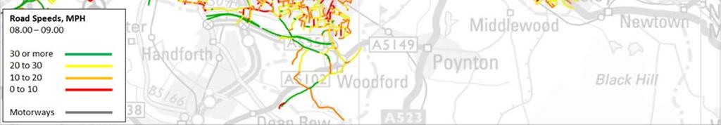
73 71 Figure Morning Peak Hour Observed Vehicle Speeds

")

74 72 Figure 5-4 Stockport Morning Peak (08:00-09:00) Average Speed by Link September 2013-August 2014.

75 73 Figure 5-5 Stockport Off-Peak (10:00-16:00) Average Speed by Link September 2013-August 2014


76 74 Figure 5-6 Stockport Evening Peak (17:00-18:00) Average Speed by Link September 2013-August 2014
77 The journey time profile (minutes per mile) for Stockport across A & B roads shows a higher level of congestion in the morning peak compared to the GM conurbation average with average speeds falling below 15 mph, as shown in Figure 5-7. Figure 5-7 Stockport and GM Journey Time Profile 2011/12 for A & B; Roads THE NATIONAL CONTEXT The road network in the study area is amongst the most congested in Greater Manchester. To put this into a national context, Figure 5-8 presents a comparison of journey times on locally managed A roads in Stockport with those across the largest urban areas in England. This shows that Stockport suffers from comparable levels of congestion to Liverpool and Birmingham and a greater level of congestion than Outer London, Newcastle-upon-Tyne, and Sheffield.
, the Alderley Edge bypass has been built, resolving the traffic problems in Alderley Edge village.")
78 76 Figure 5-8 Average journey times (flow-weighted) during the weekday morning peak on locally managed 'A' roads: annually from 2006/ Returning to the key locations identified in the SEMMMS report (Figure 5-1, above), the Alderley Edge bypass has been built, resolving the traffic problems in Alderley Edge village. The A67/A57 Denton Interchange is located on the M60 and not directly affected by the current SEMMMS road scheme proposal. The A6MARR is currently under construction and when open, this will resolve the traffic congestion along Finney Lane. The currently under development Poynton Relief Road will address the identified problems at Poynton cross-roads. Similarly, the proposed A6-M60 scheme is needed to resolve the traffic congestion problems along the A It is recognised that there is significant congestion daily, on the SE quadrant of the M60 and Highways England has plans to implement a Smart Motorway scheme along this section. The development of the A6-M60 scheme will need to be in close co-operation with the Smart Motorway scheme. JOURNEY TO WORK PATTERNS It is also worth examining the current commuting patterns in Greater Manchester to better understand how this scheme may fit within the wider GM transport offer. The GM Transport Strategy 2040 Consultation document recognises that there are "increasingly important local flows between adjacent Boroughs more widely, with all parts of the conurbation less self-contained than in the past and more reliant on flows to and from other parts of Greater Manchester" and this is illustrated in the Figure 5-9, below which shows commuting by all modes (extracted from the consultation document).
79 77 Figure 5-9 Main Commuting Flows The above diagram shows that the largest commuting flow between districts within GM is a broadly north-south movement between Stockport and Manchester and the largest equivalent flow across the GM boundary is again a north-south movement between Cheshire East and Stockport. Significant levels of commuting between Stockport and Manchester is already undertaken by the good public transport services where this is a realistic option for the commuters The A6 corridor is one of the busiest bus routes in Greater Manchester and there are high levels of cycling along the corridor. Also, the train services are well used with services along the Buxton Line suffering from over-crowding. Thus much of the through trips into the Regional centre are already made by public transport or by cycling Despite the good multi-modal transport options and their use, the A6 corridor continues to suffer from traffic congestion with much of this traffic made up of journeys with one end close to or along the A6 within Stockport, or traffic using the A6 to access the M60 as part of a longer journey. The A60-M60 scheme would directly facilitate the road traffic elements of these two largest commuting movements that support the GM economy.

80 78 JOURNEY PATTERNS ALONG THE A In addition to information on the actual traffic volumes and speeds, it is useful to understand the actual origins and destinations of traffic along the A Figure presents an illustration of the journey pattern of traffic on the A6. This shows the results of a select link analysis taken along the A6 at High Lane, from the A6MARR traffic model. Although the location of the select link is along a section of the A6 that will not be bypassed by the A6-M60 scheme, it nevertheless serves a useful purpose in helping to understand the journey patterns along the sections of the A6 that will be relieved by the proposed scheme The diagram shows the route and destination of westbound traffic on the A6 in the 2009 AM peak hour. The band width indicates the volume of this traffic on any specific link. An examination of Figure 5-10 provides a better understanding of the travel patterns and the routing chosen by traffic. This reveals that the majority of this traffic is heading to destinations to the north and west of the selected link using a variety of routes. However, very little traffic continues north along the A6 beyond Stockport town centre The dispersed nature of the destinations for this traffic means that these movements cannot be adequately catered for by public transport alternatives. Figure 5-10 Routing of Westbound Traffic on the A AM Peak 7 Extract of Figure 4.18 Appendices to the Proof of Evidence of Nasar Malik, A6MARR Public Inquiry
81 79 FUTURE TRAFFIC TRENDS Whilst at this stage of the feasibility study, no traffic forecasting work has been undertaken; we have reviewed the material available in this respect. The A6 to Manchester Airport Relief Road Forecasting Note prepared by SYSTRA in 2014 provides a summary of the percentage change in traffic between the base year of 2014 and the future years of 2017 and However, as the GM Spatial Framework is not yet published or adopted and the Cheshire East Local Plan is still subject to an Examination in Public, these forecasts do not reflect the latest housing projections The forecasts show that areas surrounding the A6-M60 route are expected to experience substantial traffic growth between 2014 and Of note are the following areas: Manchester Airport & Surrounds - 50% by 2032; Cheadle & Wilmslow - 11% by 2032; Stockport - 13% by 2032; Manchester - 21% by 2032; and South of GM - 17% by ROAD SAFETY Accident data collated by Transport for Greater Manchester (TfGM) for the period 2012 to 2014 in the Highways Forecasting and Analytical Services (HFAS) Report No presents evidence of accident clusters across the local highway network within the Stockport Council local authority area Figure 5-11 presents the location of all road injury accidents by severity type (slight, serious and fatal) across the highway network. This shows a concentration of accidents on the A6, notably between Hazel Grove and M60 motorway In terms of killed and seriously injured (KSI), pedestrian and pedal cycle accidents, Figure 5-12 and Figure 5-13 (which separately identify child and adult accidents) respectively show a concentration of KSI and pedestrian/ pedal cycle accidents on the A6 between the Hazel Grove and M60 motorway, mainly involving adults Stockport%202012%20Appendix%203.pdf


82 80 Figure 5-11 Road Injury Accidents in Stockport


83 81 Figure 5-12 Child and Adult Killed and Seriously Injured Road Accidents in Stockport


84 82 Figure 5-13 Child and Adult Pedestrian Road Injury Accidents in Stockport
85 83 IMPACT OF THE A6MARR SCHEME Phase 1 of the SEMMMS Road scheme, running between the A6 south-east of Hazel Grove to Manchester Airport, is currently under construction. This scheme, when complete, is expected to lead to a reduction in traffic flows along the A6 between Hazel Grove and the M60; the section that would be 'bypassed' by the proposed A6-M60 scheme. The A6MARR scheme is forecast to reduce flows along the A6 by between 15% and 25% over the day but with slightly smaller reductions during the peak hours Even with the reduction in traffic flows following the completion of the A6MARR scheme, this section of the A6 will still be carrying over 30,000 vehicles per day through the residential and commercial areas of Hazel Grove. Thus, whilst there will be an improvement in conditions along the A6, the route is still expected to remain congested. The level of reduction in traffic will be insufficient to reduce the A6 to a single running lane in each direction or to allow for any meaningful re-allocation of road space. SUMMARY Examination of the DfT's traffic monitoring for major roads shows that there has been an approximately 15% increase in traffic on major roads in Stockport since the publication of the SEMMMS report. The growth in traffic levels in Stockport is significantly greater than the growth in adjacent local authority areas The analysis of traffic speeds and delays confirms the very congested travel conditions on the study area road network. Comparison against journey times in other major cities shows that the local traffic conditions are amongst the worst nationally Analysis of Journey to Work patters shows that the movements between Stockport and Manchester and Stockport and Cheshire East are the two largest cross-boundary movements in the area. It is evident that the majority of through trips into the Regional Centre are already made by the good public transport services some of which suffer from over-crowding The select link analysis confirms this and shows that the majority of traffic along the A6 south of Hazel Grove is accessing areas off the A6 or accessing the M60 motorway. The analysis shows the much dispersed nature of origins and destinations, confirming that the bulk of trips could not be catered for by the provision of any realistic public transport alternative Traffic Forecasting work undertaken for the A6MARR scheme indicates a substantial increase in road traffic between 2014 and 2032 across the study area for the A6-M60 scheme The road accidents statistics show a large number of accidents along the A6 through Hazel Grove and Stockport town centre, as well as along east west routes such as the A560 through Cheadle and Finney Lane through Heald Green It is clear from the evidence presented in this section that the problems which the SEMMMS road schemes were recommended to address, still remain and in many cases have become worse since the SEMMMS strategy was published in The A6-M60 scheme would remove unnecessary traffic from the A6, freeing up the road for public realm improvements as well as enabling more use by sustainable transport modes. The removal of a large volume of traffic from the A6 will reduce the current substantial severance caused to pedestrians and this in turn would improve road safety Based on the review of contemporary traffic and travel data, it is clear that there remains a strong case for the A6-M60 scheme set as out in the original SEMMMS strategy.
86 THE ORIGINAL SEMMMS TRAFFIC MODELS SEMMMS STRATEGY FINAL REPORT A number of traffic modelling tools were developed to inform the 2001 SEMMMS Strategy The Greater Manchester Strategy Planning Model (GMSPM) was used to generate growth forecasts, test the impact of key options for the strategy to inform the appraisal process and assess the impact of the recommended strategy on the patterns and volumes of trip making in the area A detailed model of the study area highway network was developed using the Sub Regional Highway Model (SRHM). The SRHM was a link-based TRIPS model and did not represent the queuing and delay at junctions. Network coverage was similar to the current SATURN model A Public Transport Model was developed with updated public transport services. The mode choice between the main modes (highways and public transport) is carried out by GMSPM. The public transport model allocates public transport demand between the public transport sub-modes (rail, bus etc.) The models were developed for peak and inter-peak hours for a base year of 2000 and a forecast year of Each model was developed to best practice standards (it is not stated what these standards were) OUTLINE BUSINESS CASE SUPPORTING DOCUMENT E4: LOCAL MODEL VALIDATION REPORT JULY The Local Model Validation Report was produced by GMTU (now TfGM HFAS) to document the development of the traffic model used in the Outline Business Case The forecasting model used was the Greater Manchester Sub-Regional Highway Model (SRHM). The model is a highways model using the Trips software package. SRHM covers Greater Manchester along with parts of Lancashire, Cheshire and Derbyshire. The full extent of the SRHM was used to assess the impacts of the Scheme A number of traffic counts were undertaken in the immediate study area in The validation of the model was assessed against the requirements set out in Volume 12a of the Design Manual for Roads and Bridges (DMRB). The model achieved a good level of validation. SEMMMS NEW RELIEF ROAD SCHEME ECONOMIC UPDATE FURTHER INFORMATION FOR DFT OCTOBER This document provided further information to the DfT on the economic appraisal of SEMMMS Of relevance to the A6 M60 Relief Road is the breakdown of the economics into the Northern section and the Southern section. The Northern section covers the scheme covered by the A6 M60 Relief Road On its own the Northern section A6-M60 Relief Road scheme would generate a positive BCR of The appraisal also shows that with the construction of the Poynton Relief Road the Northern section scheme generates a BCR of 5.31, which represents very high value for money (in accordance with the WebTAG definition for BCRs that exceed 4.0).
87 Based on the local traffic conditions and other information available at this point in time, there is no evidence to suggest that the A6-M60 scheme would not continue to demonstrate high value for money. 5.6 A6MARR PLANNING APPLICATION A6MARR LOCAL MODEL VALIDATION REPORT FEBRUARY This LMVR describes the development of the 2009 A6MARR SATURN Model. The model validation followed the guidelines set out in WebTAG The model was used to provide traffic forecasts to support the A6MARR Outline Business Case and to provide inputs into the Variable Demand Model A good level of model validation was reached. A6MARR FORECASTING NOTE NOVEMBER This Technical Note describes the forecasting approach, including future year assumptions and results, to support the A6MARR Major Scheme Business Case Traffic forecasting was undertaken following guidance set out in WebTAG Unit M4 (May 2014). An Uncertainty Log was collated to identify and include planned local developments in the future year forecasts. The background growth was derived from GMVDM, which would have been constrained to NTEM Future Year Traffic forecasts were produced for a 2017 scheme opening year and a 2032 design year. A6MARR VDM MODEL DEVELOPMENT REPORT NOVEMBER This report sets out the development of the A6MARR Variable Demand Model (VDM). The model was updated in 2014 to bring the model in line with the latest DfT guidance The A6MARR VDM contains three components: SYSTRA s bespoke VDM; SATURN Highway Assignment Model; and PT-TRIPS Public Transport Model The elasticities within the model were within acceptable values. The report concludes that the A6MARR VDM is a suitable tool to inform the appraisal of the A6MARR major scheme An updated A6MARR Model that would incorporate the new data collected since the model was used for the A6MARR assessment, would be the appropriate tool to use for the further development and assessment of the A6-M60 Relief Road scheme. 5.7 PREVIOUS DATA COLLECTION INTRODUCTION In 2009, the A6MARR Project Board commissioned the then Greater Manchester Transportation Unit (GMTU) to develop models to inform production of a Major Scheme Business Case for the proposed A6MARR (A6 to Manchester Airport Relief Road).
88 To assist in development of the A6MARR models, a significant amount of new data on traffic patterns and volumes was collected within the identified scheme Area of Influence (AOI) In autumn 2013, Cheshire East Council (CEC) undertook additional data collection (origindestination surveys and counts) in the southeast of the AOI to inform consideration of transport issues in the area. This data was supplied to the A6MARR team to support extension of the detailed modelled area and the revalidation/calibration of the highway and variable demand models. ROAD SIDE INTERVIEW SURVEYS There have been six major sets of roadside interview surveys (RSI) in Greater Manchester since the beginning of the decade, which are relevant to the A6MARR area, these are as follows: 2013 Cheshire East Surveys To support the development of the Poynton Relief Road scheme, Cheshire East Council conducted surveys in October and November 2013 on single weekdays during school term time. Survey hours were 07:00 19:00. A set of automatic traffic counts, manual classified link counts (by direction) and turn counts was also carried out in the same area to assist model development The data was collected by Sky High-Count On Us, with traffic being surveyed in both directions at each location. Two types of survey were undertaken, depending on site location and layout: Face-to-face interviews. Postcard surveys Automatic traffic counts were undertaken at each site for a two-week period covering the interview date. These counts were used for data expansion The 2013 Cheshire East surveys were carried out in order to augment the existing data and inform extension of the SATURN simulation area to include an area extending from the A523 eastwards through Belington and Whaley Bridge to Chapel-en-le-Frith. The extended simulation area will improve representation of routes linking the key A6 corridor with the A523. Traffic was surveyed in both directions on key routes in the extended simulation area to provide as complete a picture of traffic movements as possible. A6MARR Roadside Interview Surveys Phase A The A6MARR (Phase A) roadside interview data was collected in October 2009 at 46 sites. The sites formed two cordons in the study area, to intercept movements to and from: Manchester Airport / Wythenshawe. Cheadle Hulme / Wilmslow / Heald Green To reduce the costs of the surveys, and avoid causing unnecessary disruption to traffic, the A6MARR RSI data was supplemented with information from 11 sites that were surveyed during the GMATS and M60 After Study RSI surveys, which were used to fill holes in the A6MARR cordons The SEMMMS RSI data was collected by Sky High PLC, with traffic being surveyed in both the inbound and outbound directions for each cordon. Two types of interview were undertaken: Face-to-face interviews. Postcard surveys.
89 In total, 19 sites were surveyed using face-to-face interviews, with 25 of the sites being surveyed using the postcard technique. Two sites were surveyed using a mixture of face-to-face interviews and postcards. A6MARR Roadside Interview Surveys Phase B The A6MARR (Phase B) roadside interview data was collected in June 2011 at 5 sites. The sites formed a cordon in the study area, to intercept movements to and from Stockport (south of M60), Hazel Grove, High Lane and Poynton To complete the cordon A6MARR RSI data was supplemented with information from 11 sites that were surveyed during the GMATS and M60 After Study RSI surveys. Data from the re-used GMATS/M60 After Study sites was re-expanded to present day ATC counts collected during the A6MARR surveys Phase B surveys were undertaken by Nationwide Data Collection, with traffic being surveyed in either the inbound or outbound directions for the cordon In total, 3 sites were surveyed using only face-to-face interviews, 1 site was surveyed using only the postcard technique. One site was surveyed using a mixture of face-to-face interviews and postcards Both sets of A6MARR surveys were undertaken on weekdays between 0700 and 1900 for drivers of cars, Light Goods Vehicles (LGV) and Other Goods Vehicles (OGV). (Motor cycles and pedal cycles were also surveyed, although these interviews were not expanded or used for matrix building) Automatic traffic counts were undertaken at each site for a two-week period covering the interview date. These counts were used for data expansion, with the ATC count on the day of the survey being excluded to ensure that the data expansion was representative In addition, two-way manual counts were also collected on the day of the survey to monitor and control the sampling. These counts were also used to disaggregate the ATC data, to allow the interviews to be expanded separately by vehicle type. JOURNEY TIME DATA Traffic master Data Observed journey times on a number of routes in the A6MARR Area of Influence were obtained from the Traffic master database In addition to this, extra routes were identified located within the Cheshire East area to assist in extending the simulation network in the existing A6MARR highway scheme model. HFAS currently hold data for Greater Manchester and a 10 KM buffer surrounding the county (thereby including a substantial part of northern Cheshire). Data is currently available from September To validate the SATURN models, the modelled times have been compared with observed times collected during 2009 for the morning peak hour , the evening peak hour and the inter-peak period Fifteen routes (two directions each) were extracted from the Trafficmaster database for the A6MARR Area of Influence. A further six routes (two directions each) were extracted for the Cheshire East area. In all, the journey time routes cover approximately 360km of the highway network in the A6MARR area.
90 88 TRAFFIC COUNTS Data for Greater Manchester - GMCOUNTS Database HFAS undertakes manual classified traffic counts (MCCs) on links and at junctions on behalf of Greater Manchester s District Councils and other clients, including the DfT. The link counts are mainly 12-hour continuous, undertaken between 07:00 and 19: Most turning counts are discontinuous short-period counts, which usually cover the peak periods (07:30-09:30 and 16:00-18:00) and a 2-hour period in the inter-peak (usually 10:00-12:00, or 12:00-14:00) In addition to the MCCs, GMCOUNTS also holds data from automatic traffic counters (ATCs). ATC s consist of ad hoc and fixed sites. The fixed ATC sites are spread throughout Greater Manchester and provide continuous monitoring of traffic from year to year. The data from these sites are generally used to monitor long term trends in traffic flow A number of counts were undertaken by HFAS specifically for the A6MARR study. For example, manual counts were done and ATC installed to provide expansion factors for trips observed at each roadside interview survey site (Phases A & B). Data for Cheshire East Count data for the northern part of Cheshire East was provided by that local authority and processed/reviewed by Mott MacDonald. The data consisted of a mixture of manual classified and ATC data collected over the period 2007 to In addition to this, more counts were collected in the Cheshire East area in 2013 and Data for Highways England Roads The TRADS database provides online access to the ATC data collected by the Highways Agency on motorways and strategic roads. The database holds data for some 15,000 sites of which around 9,000 are currently active On-going engagement is being carried out with Highways England throughout this study to ensure data is shared to minimise repeat surveys. Airport Count Data The set of counts used to establish the SEMMM7B SATURN model also included automatic traffic counter (ATC) data collected by HFAS on behalf of Manchester Airport. HFAS maintain and operate a cordon of ATC sites around Manchester Airport, providing traffic flow data for five key roads serving the Airport terminal area or the Cargo Centre. EXISTING DATA COLLECTION SUMMARY This chapter has shown that a wide range of data has previously been collected and is available to inform the assessment of existing transport conditions and the future assessment of the scheme impacts. However, to ensure that the future appraisal meets DfT requirements, data older than 5 years should not be used in the assessment. As a result, additional data collection will be required to bring the data set up to standard and this is discussed below.
91 FURTHER DATA REQUIREMENTS Based on our review of existing data, we consider that no new origin-destination data is required for the Stage 2 study. Whilst recognising that data from the 2009 surveys conducted for the A6MARR scheme is now seven years old, newer origin destination data is incorporated within the models from the 2013 Cheshire East surveys. We are aware that Highways England has, for schemes at this stage of development, accepted origin destination up to ten years old, but supplemented by more recent traffic count data used to produce a present year model validation The A6MARR scheme will be complete and open to traffic in It would be appropriate to collect new origin-destination data in 2018 once traffic patterns have settled down after the opening of the new road For the current feasibility study, a data collection programme has been developed and undertaken with TfGM. This new traffic count data will allow a detailed calibration and validation of the traffic model to be undertaken in the A6 M60 study area and will ensure that the model meets DfT requirements. Link count surveys were undertaken at 61 sites across the study area in May and June A summary of the data collection exercise is provided in Appendix SUMMARY AND CONCLUSIONS This chapter has shown that since the publication of the SEMMMS Strategy in 2001 traffic growth in Stockport has significantly out-stripped the growth in adjacent authority areas. Analysis of speed data across the Stockport highway network shows that the network suffers from congestion throughout the day with average speeds of below 10mph for much of the day. A review of the origin and destinations of trips along the A6 shows that trips are dispersed and as a result could not be accommodated by public transport options. Accident data shows that there are a significant number of personal injury accidents along the A6 through Stockport The analysis of contemporary traffic data shows that the case for the A6 M60 Relief Road has strengthened since the publication of the SEMMMS strategy A review of the existing appraisal work to date shows that a range of modelling and data collection has been undertaken to support the development of the scheme in line with DfT guidance. The review has shown that existing models could be updated with new traffic survey data to inform the future appraisal of the scheme Following a review of previous data collection, further surveys were commissioned and undertaken in May and June 2016 in order to inform Stage 2 of this study. The new survey work will ensure that future modelling meets DfT requirements. The data collection specification Report is provided in Appendix The Chapter has demonstrated the need for intervention still exists since the SEMMMS strategy was published in It has also identified the data collection requirements to support future work.
92 90 6 HIGHWAY DESIGN OPTIONS REVIEW 6.1 INTRODUCTION This chapter provides a high level highway review of the previous study for the A6 M60 Relief Road The following data was sourced from the data room at Stockport Metropolitan Borough Council: Executive Summary of SEMMMS; Consultation Report; Risk Assessment; Highway General Arrangement Drawings for the A6-M60 route; Highway General Arrangement Drawings for the scheme extent to the A6-Manchester Airport Relief Road; 3D MX model The primary objective of this chapter is to understand the extent and scope of the previous work completed to date and highlight key issues which will need to be drawn into the proposal. Identifying and sourcing the existing study data; Review of the existing studies and data; Key issues and objectives will be determined or reinforced which the proposals will need to address; Review of the key elements of the highway design including design assumptions and the draft horizontal and vertical alignment; Review of the Consultation Feedback; Interface of the current A6 to Manchester Airport Relief Road will be considered; Consider issues concerning the Highways England property along the A6 to M60 route; High level appraisal of the SEMMMS OBC Risk Register; and Planning cycle network and routes A significant factor influencing the key issues and factors which will need to be determined is due to the time lapse since any development work was undertaken. The design freeze on the scheme dates to 2005 and any changes in design standards would not have been incorporated since. 6.2 TASK OBJECTIVES IDENTIFYING AND SOURCING THE EXISTING STUDY DATA WSP Parsons Brinkerhoff have been granted access to the archive records which were used during the development of the previous study. Some of the information was available in hardcopy format only and scanned for distribution to the project team The information which was sourced from the data room at Stockport Metropolitan Borough Council and reviewed to compile this report as follows:
93 91 Executive Summary of SEMMMS; Consultation Report; Risk Assessment; Highway General Arrangement Drawings for the A6-M60 route; Highway General Arrangement Drawings for the scheme extent to the A6-Manchester Airport Relief Road; and 3D MX model. REVIEW OF THE SEMMMS STRATEGY AND DATA Following a review of the existing studies and data at Stage 1, the key issues and objectives will be determined/reinforced that the scheme proposals will need to address The objective for the SEMMMS was to develop a long term (20 year) transport strategy that established an implementation plan of specific interventions to address the problems within the study area. The study area covered the following conurbations: All of Metropolitan Borough of Stockport; Parts of the City of Manchester; Parts of Tameside Metropolitan Borough; Parts of Macclesfield Borough; and Parts of High Peak Borough, Derbyshire The core objectives were defined and agreed as follows: The promotion of environmentally sustainable economic growth; The promotion of urban regeneration; The improvement of amenity, safety and health; The enhancement of the Regional Centre, town centres and local and village centres and the Airport; and The encouragement of the community and cultural life of neighbourhoods, and encouragement of social inclusion The recommended strategy for roads was to build local bypasses along protected alignments rather than to build at the scale and standard originally proposed. The suggested local bypasses were: Between the M60 at Bredbury and the A6 at Hazel Grove following the protected alignment for the A6(M) and incorporating the Stepping Hill Link between the A6 north of Hazel Grove and the new road. The north-south bypass should be constructed as a dual carriageway with a 40/50 mph design speed, at grade and signal controlled junctions. A Poynton bypass comprising of an east-west section linking the A555/A5102 junction north of Woodford to the A6 at Hazel Grove. A dual carriageway is proposed with junction at-grade. For the north-south bypass of the A523 a single carriageway is recommended from the existing A523 at Adlington, joining the east-west section of the bypass north of Woodford. A reduced scale scheme in the MALRW corridor. An at-grade dual carriageway linking the Airport roundabout at the end of the M56 spur to the Western End of the A555 at Handforth with an at-grade junction at Styal Road is recommended.
94 The currently under construction A6MARR scheme includes the link between the A5102 / A555 junction and the A6 at Hazel Grove as well as the link formerly known as MALRW between Handforth and the M56 spur at Manchester Airport. The junction at the Oil Terminal has been designed to allow for a future connection for the Poynton Relief Road The Poynton Relief Road is progressing through the development stages with a target date for opening in early With the closure of the BAE Systems runway, the scheme alignment has changed from that originally proposed for Poynton Bypass now that there is no need for the road to pass around the runway. REVIEW OF THE KEY ELEMENTS OF THE HIGHWAY DESIGN INCLUDING DESIGN ASSUMPTIONS AND THE DRAFT HORIZONTAL AND VERTICAL ALIGNMENT A review of the key elements of the highway design covering the horizontal and vertical alignment was undertaken. This was a nominal review to cover the concept of the design compliancy with the design standards and it s adequacy for further development The existing mainline drawings and the results from the geometric checks are contained in Appendix 6 and 7 respectively The geometric parameters extracted from the 3D MX model and profile sections provided with the available data comprised of the following checks against the Design Standard for Roads and Bridges TD9/93: Minimum horizontal radius for design speed; Transition lengths between radii; Super-elevation for radii below Table 3 from TD9/93; Vertical alignment check for minimum K values in hog and sag curvatures; and Minimum and maximum gradient permissible for road category The proposed mainline cross-section for the scheme is a rural Dual 2 Lane All-Purpose (D2AP) carriageway comprising of the following: Two lanes with a total width equal to 7.3m width; 1m Hardstrips to both the nearside and offside; 2m Verge width where a footway is proposed and 2.5m in the absence of a footway; Footway width of 3.0m; and Central reserve width of 2.5m The following design assumptions were made as the basis of the checks: All checks were made to the alignment titled Design Freeze 4A Mainline Design ; A design speed of 50mph (85 kph) to be maintained throughout the extents of the scheme; and A rural mainline cross-section (D2AP) The results from Appendix 7 identified isolated areas of non-compliant super-elevation and transition lengths. A check on the vertical alignment identified isolated areas of non-compliant gradients.
95 In summary of the highway alignment checks in Appendix 7, there are no significant concerns towards the design compliancy of this preferred alignment. The isolated areas of non-compliant standards could be due to design errors and omitted with further development or sought for departure from standards approval. REVIEW OF THE CONSULTATION FEEDBACK A consultation took place from October 2003 to January 2004 to collect the view of the people in Stockport, and selected areas in Cheshire and Manchester on the proposed SEMMMS New Relief Road Scheme. The key outcomes from the 11,559 responses were: 91.6% thought that the scheme was needed to bring traffic relief to the local communities and businesses; 87.4% agree in the principle of the road scheme as recommended by SEMMMS; 87.6% in broad terms thought that the proposed route was in the right corridor; and 6% disagreed with the scheme being required for the following main reasons: More roads will only create more congestion; Loss of local countryside and natural environment i.e. Goyt Valley; and Public money better spent on upgrading public transport A number of respondents asked for alterations or additions to the route. The following comments were considered by the design team and incorporated into the design: Woodford Road junction should be an underpass with slip roads and not a roundabout; Junction at Osborne Street is not needed and will only increase the problem of congestion at Bredbury; and Junction is required at Poynton A number of respondents asked for alterations or additions to the route. The following comments were considered by the design team and but not incorporated into the design: A bypass from proposed A6 (Buxton Road junction) for High Lane and Disley to Whaley Bridge should be considered; The new route should be extended from the A523/ Bonis Hall Lane and extra half mile through open countryside to meet up with the end of Silk Road junction; The scheme should consider going across Hazel Grove and Stockport golf courses. This would enable a suitable junction to be site at the Seventeen Windows / Dooley Lane area, thus reducing the immense volume of traffic on the A626 Marple Road / Stockport Road; and Scrap the Stepping Hill Link parking at hospital already impossible and road junction outside Sainsbury car park carries enough local traffic The majority of respondents were in favour of the Manchester Airport to Wimslow Road section being completed first since it was the shortest section and would relieve congestion on the A The comments received from consultation and which were not incorporated into the design (listed in Section 3.5.3) shall be appraised as separate entities and filtered for further development.
96 94 INTERFACE OF THE CURRENT A6 TO MANCHESTER AIRPORT RELIEF ROAD WILL BE CONSIDERED The A6-Manchester Airport Relief Road (MARR) is currently being constructed to Dual 2 Lane All- Purpose (D2AP) standard and is planned to provide 10 km of new carriageway. The east-west route starts from the A6 near Hazel Grovel, via the 4 km of existing A555 to Manchester Airport and the link road to the M56 (See Appendix 8) The proposed A6-M60 is intended to tie into the A6-MARR at the location of the T-junction on the A6, approximately 260m east of Buxton Road. The form of the new junction will be determined following traffic modelling and public consultation A review of both carriageways at the proposed tie-in points showed that: The proposed levels differ from both designs; The central reserve width differ from both designs; and Carriageway, hard-strip, footway and verge widths are consistent for both cross-sections The works will involve significant earthwork alterations on the A6-M60 section where it is proposed to tie-in with the A6-MARR alignment. The drainage for either section will be required to be treated separately serving individual outfalls and discharge controls Due to the time lapse in the development of both schemes, it is evident that there will need to be substantial consideration and re-design to the A6-M60 section. This will ensure the interface between the highway schemes is consistent. CONSIDER ISSUES CONCERNING THE HIGHWAYS ENGLAND PROPERTY ALONG THE A6 TO M60 ROUTE A plan showing the overall land required based on the current alignment has been included in Appendix 9. The plan also incorporates lands which are currently owned by the Department for Transport (DfT) (source: Stockport Metropolitan Borough Council GIS, 2005) and land identified to be purchased from the original study A majority of the land required to facilitate the construction of the A6-M60 has not been purchased. The DfT has acquired some of the land according the data provided, most notably the land around the M60 Junction 25 at Bredbury It is evident that the total land acquisition will require further development and may be subject to change due any design changes such as junction layouts etc. The areas identified from the original study highlight areas outside the extents of the scheme which may have been superseded due to further changes in the alignment design. HIGH LEVEL APPRAISAL OF THE SEMMMS OUTLINE BUSINESS CASE RISK REGISTER A high level appraisal of the SEMMMS OBC Risk Register has been undertaken. The work was undertaken in 2003 and will contribute to the major changes in regards to pricing. The following key points have been derived following a review of the document: The risk register has been modelled under a simulation method derived by Highways England called HARM which is based on the Monte Carlo Simulation. This method has now become obsolete with the Highways England method of working.
97 95 Highways England no longer applies optimism bias to their estimates. They produce range estimates based on their pricing modeller software which applies risk, uncertainty, unscheduled items and inflation. The software runs off the roadworks estimator forms and is based on HE historic rates stored in their database. The VAT needs to be applied at 20% (not 17.5%) and an inflation index applied since 2003 to current. The risk register has been compiled comprehensively and fit for purpose. JUNCTION STRATEGIES Detailed traffic modelling will be required to determine the configuration of the proposed junctions. For example, the traffic modelling will determine the peak flows which will be used to select the appropriate merge/diverge layout in accordance with DMRB TD22/ There is scope for junction alterations, such as looking at through-abouts and segregated left turn lanes which can reduce land take and increase capacity. M60 JUNCTION 25 SMART MOTORWAY INTERFACE As part of the review of the existing information, communication with Highways England has been established who have informed us of its intention to implement a SMART motorway scheme at this location. The SMART motorway scheme is currently at a very early stage without any significant development to inherit The proposed A6-M60 will need to incorporate civil works associated with the communication systems proprietary to Highway England s requirements. Possible additions which will require further development have been listed below: The A6-M60 connector road at Junction 25 may require provisions for ramp metering to assist and regulate traffic joining the M60. However, it is possible that traffic queues on the A6-M60 connector road may build-up back to Crookilley Way roundabout which can severely affect capacity and possibly influence the geometry of this junction. Display information through appropriate technology will be required on the A6-M60 section to inform drivers of incidents or speed restrictions further upstream on the M60. These works will require additional civil works with possible changes to the cross-section. Appropriate technology for monitoring traffic flows will be necessary on the southbound A6-M60 section. Early warning signs of traffic build-up will need to be communicated with the Highway England control network and to work interactively with the proposed SMART motorway technology. It is evident that the current alignment will be liable to design changes when the SMART motorway scheme develops. The phasing of the works will be critical as either scheme may need to be future-proofed to incorporate the technology proposals and so close working will be required with Highways England.
98 96 PLANNING CYCLE NETWORK AND ROUTES The development of the cycle network shall be mainly focused with appropriately managing of existing highway, right-of-way, permissive routes and creating new links within the existing network An enhanced review of the current provisions provided for pedestrian and cyclists shall be updated to synchronise with objectives defined within the national and local transport plans. The following levels of provisions shall be planned for achieving: The link to fully integrate with existing local cycle and pedestrian network to maximise access to the new route; Minimise disruption to Public Rights of Way and improve where possible; Planning and design for cycle users and pedestrians dependant on use i.e. commuting or leisure; and Applying appropriate detail in provision to enable coherence, directness, attractiveness, safety and comfort which are expected from current standards and strategies. 6.3 CONCLUSION AND RECOMMENDATIONS The following recommendations can be drawn from the Stage 1 study: Due to the time lapse in the development of the A6 Manchester Airport Relief Road and A6- M60, there will need to be reconsideration of the design of the A6-M60 at the interface with the A6MARR to ensure consistency of design. The total land acquisition will require further development and may be subject to change due any design changes such as junction layouts etc. The areas identified from the original study highlight areas outside the extents of the scheme which may have been superseded due to further changes in the alignment design. The scheme needs to consider the SMART motorway proposal on the M60 since it will likely change the design of the current alignment. The phasing of the works will be critical as either scheme may need to be future-proofed to incorporate the technology proposals. The proposed A6-M60 will need to incorporate civil works associated with the communication systems proprietary to Highway England s requirements. Detailed traffic modelling will be required to determine the configuration of the proposed junctions. An enhanced review of the current provisions provided for pedestrian and cyclists shall be updated to synchronise with objectives defined within the national and local transport plans.
99 97 7 ENVIRONMENTAL REVIEW 7.1 INTRODUCTION The chapter identifies the potential environmental constraints early in the design process and actions to be carried out during later stages of the project based on a review of the 2003 Environmental Assessment. However, it must be remembered that further scheme development work was undertaken up to 2006 and a number of significant changes were introduced that would have a significant effect on the environmental assessment of the scheme that is not captured within the 2003 assessment reported here. For that reason details of the proposed scheme are not discussed in this section, but can be reviewed in the introductory section of this report The study has been undertaken following the Government s announcement to provide funding to Greater Manchester Combined Authority to undertake a study, which will consider the economic and financial cases for an A6 to M60 Relief Road ensuring that it would provide good value for the tax payer and proper consideration of the environmental effects The associated study will need to consider the strategic justification for the scheme in the context of the Greater Manchester Growth Plan and implications of the aspiration of the Northern Powerhouse agenda The objectives of the environmental review are to establish the: Issues and likely impacts affecting the preferred alignment of the A6 to M60 relief road on the environment; Issues that have the potential to pose the greatest risk to the environment and future success of the Scheme; and Suitability of the studies produced to date for the environmental supporting justification for the WebTAG submission and to subsequently secure planning permission. 7.2 SCOPE AND CONTEXT The 2003 Scheme considered 3 main options A, B and C and several sub options. As the scheme has already been subject to an options appraisal, at this stage the preferred option (2003) is under review. Should the design work during Stage 2 (or beyond) determine different design options, these should be considered as advice on the environmental implications that will be required The baseline information has been obtained through desk studies from readily available information sources including: the previous environmental studies and assessment prepared to support the wider SEMMMS Major Road Schemes in 2003, web based resources (including magic maps); and WSP PB systems Further monitoring and survey work will be required at later stages of the design process, in order to close data gaps caused by: Out of date information; Incomplete assessment; Issues arising from separating the scheme into phases; Changes to the preferred design or design options; and Changes in legislation.
100 The previous Environmental Assessment was undertaken by Mouchel in 2003 for the entire SEMMMS route between the M60 and Manchester Airport. This report considers Option A for Sections 1 to 4 of the 2003 scheme, as the other sections are not relevant to the current proposals Environmental legislation has been updated since the previous environmental scoping report and assessments were carried out. Interim Advice Note 125/15 entitled Environmental Assessment Update dated October 2015 (IAN125/15) sets out the latest approach that is used to meet the objectives of DMRB Volume The table below sets out the previous structure and the proposed new structure of subsequent reports to be produced for the A6-M60 Relief Road. Table 7-1 : Comparison of environmental topics between the 2003 Environmental Assessment and IAN125/15 (October 2015) PREVIOUS ENVIRONMENTAL TOPIC HEADING Air Quality Cultural Heritage Landscape Effects Ecology and Nature Conservation Geology & Soils Noise & Vibration Vehicle Travellers Pedestrians, cyclists, equestrians and community effects Land use Water Quality and Drainage Policies and Plans Disruption due to Construction REVISED ENVIRONMENTAL TOPIC HEADING (AUGUST 2008) Part 1: Air Quality Part 2: Cultural Heritage Part 3: Landscape Part 4: Nature Conservation Part 5: Geology & Soils Part 6: Materials (to include waste) Part 7: Noise & Vibration Part 8: People and Communities Part 9: Road Drainage and the Water Environment N/A N/A CHANGES TO THE CONTENT OF EACH TOPIC AT THE TIME OF WRITING Individual Policies & Plans and Disruption due to Construction sections included as part of each topic. This new title entitled People and Communities merges the previous chapters on Land Use, Pedestrians, cyclists, Equestrians and Community Effects; and Vehicles. Individual Policies & Plans and Disruption due to Construction sections included as part of each topic. Impact on Road Schemes on Policies and Plans has been absorbed into each of the new topic chapters. This chapter has also been absorbed into each of the new topic chapters.
101 SUMMARY OF PREVIOUS ENVIRONMENTAL ASSESSMENTS The following section provides a summary of the findings of the 2003 Environmental Assessment for the entire SEMMMS route comprising the A6-M60, the A6MARR and the Poynton Relief Road schemes. The majority of the baseline information, regulations and guidance on assessment methodologies and the policy context from that time are now out of date. As this is a gap in the existing information a review of relevant policies for each future Environmental Assessment chapter should be carried out during future stages of the project. PURPOSE The objective of this environmental appraisal is to provide an environmental constraint assessment and highlight a set of mitigation actions for the Scheme s relevant environmental issues. Some sections are more detailed than others; this is due to the suitability of the 2003 information differing between topic areas. PART 1: AIR QUALITY An air quality assessment was carried out in 2003 as part of Environmental Assessment for the entire SEMMMS route. The purpose of the air quality assessment was to establish the extent to which potentially sensitive receptors are likely to be affected by changes in air quality as a result of the proposed Scheme. This assessment considered both beneficial and adverse impacts Assessments of the preferred route show that the negative impacts on air quality were lower than some of the other options. Although fewer properties are predicted to experience an improvement in air quality, fewer properties would also experience deterioration in air quality. A significant proportion of receptors would experience near background pollutant concentrations. Actions The results of this screening assessment indicate that further assessments of air quality will be required and should include detailed dispersion modelling to be undertaken specifically in areas where considerably elevated levels of NO2 and PM10 have been predicted. In addition, it will be necessary to conduct detailed modelling for all emission points at the proposed tunnel, addressing impacts on local air quality The traffic data used for this assessment is now out of date. As a consequence an updated traffic forecasts will be required. The outputs from this exercise will be used to carry out an updated air quality assessment. The Stage 2 study will set out a strategy and the scope of work required for producing a new Environmental Statement. This will include giving more detailed consideration to future air quality modelling work that will need to be undertaken. PART 2: CULTURAL HERITAGE The 2003 cultural heritage assessment found that there are no World Heritage Sites, Scheduled Monuments or Registered Battlefields located along or in close proximity to the route. However, there are a number of Listed Buildings and Structures and Registered Parks and Gardens nearby. The report drew together the results of previous assessments of the various elements of the scheme undertaken between 1991 and 1994 and updates, expands and amends these where necessary The 2003 document includes a list of historic properties from the sites and monuments record. This list will require review and updating by the archaeology specialists. However, a provisional current schedule of listed building put together using the data from magic maps in June 2016 is listed below:
102 100 Table 7-2 Provisional Schedule of Listed Buildings NAME GRADE GRID REFERENCE BARN IMMEDIATELY EAST OF BREDBURY HALL CHURCH OF ST MARK GOYT HALL II II II Easting Northing Easting Northing Easting Northing APPROXIMATE DISTANCE FROM PREVIOUS PREFERRED ROUTE ALIGNMENT 301 Metres 1,127 Metres 202 Metres BARN TO WEST OF GOYT HALL II Easting Northing Metres HALLIDAY HILL FARMHOUSE OFFERTON HALL FARMHOUSE II II Easting Northing Easting Northing Metres 182 Metres TORKINGTON HALL FARMHOUSE THE COUNCIL HOUSE II II Easting Northing Easting Northing Metres 790 Metres BEECH HOUSE, ADJOINING COACH HOUSE AND FRONT RAILINGS II Easting Northing Metres LYCHGATE AT CHURCH OF ST THOMAS II Easting Northing Metres CHURCH OF ST THOMAS II Easting Northing Metres
103 101 NAME GRADE GRID REFERENCE WAR MEMORIAL, ENTRANCE GATES, WALL AND RAILINGS IN MEMORIAL GARDENS II Easting Northing APPROXIMATE DISTANCE FROM PREVIOUS PREFERRED ROUTE ALIGNMENT 611 Metres THATCHED COTTAGE II Easting Northing ,476 Metres PEAR NEW MILL II* Easting Northing ,027 Metres WOODBANK VILLA AND ENTRANCE PORTICO II* Easting Northing Metres THE STRAWBERRY GARDENS PUBLIC HOUSE II Easting Northing ,462 Metres STOCKPORT MUSEUM IN VERNON PARK II Easting Northing ,558 Metres VERNON MILL II Easting Northing ,769 Metres ARDEN HALL II Easting Northing ,352 Metres BARN DATED 1716 AT ARDEN GARAGE II Easting Northing ,254 Metres CASTLE HILL FARMHOUSE II Easting Northing ,344 Metres NUMBER 12 BRIDGE ON PEAK FOREST CANAL II Easting Northing ,711 Metres
104 102 NAME GRADE GRID REFERENCE WOODLEY TUNNEL, NORTH PORTAL AT SJ ON PEAK FOREST CANAL II Easting Northing APPROXIMATE DISTANCE FROM PREVIOUS PREFERRED ROUTE ALIGNMENT 1,618 Metres WOODLEY TUNNEL, SOUTH PORTAL AT SJ ON PEAK FOREST CANAL II Easting Northing ,546 Metres 105, HYDE ROAD II Easting Northing ,485 Metres NUMBER 13 BRIDGE ON PEAK FOREST CANAL II Easting Northing ,484 Metres BREDBURY HOUSE II Easting Northing Metres HARRYTOWN HALL II Easting Northing Metres HATHERLOW HOUSE II Easting Northing Metres THE SPREAD EAGLE PUBLIC HOUSE II Easting Northing Metres HATHERLOW UNITED REFORMED CHURCH II Easting Northing Metres AQUEDUCT OVER GREEN LANE ON PEAK FOREST CANAL II Easting Northing ,034 Metres HIGHER WATERSIDE FARMHOUSE II Easting Northing Metres
105 103 NAME GRADE GRID REFERENCE OTTERSPOOL BRIDGE II Easting Northing APPROXIMATE DISTANCE FROM PREVIOUS PREFERRED ROUTE ALIGNMENT 789 Metres RIDGE COTTAGES II Easting Northing Metres SHADY OAK FARMHOUSE II Easting Northing Metres TOP O' THE GREEN FARMHOUSE II Easting Northing Metres HILL VIEW COTTAGE HONEYSUCKLE COTTAGE ROSE COTTAGE ROSE LEA COTTAGE II Easting Northing Metres 4 AND 6, MARPLE OLD ROAD II Easting Northing Metres WOOD FARMHOUSE II Easting Northing ,127 Metres MAIN ISSUES AFFECTED BY THE PROPOSALS The findings from the 2003 study showed that no Scheduled Ancient Monuments were affected by the proposals, and no impacts were identified on conservation areas. However, there may be an impact on listed buildings, for which the impacts will be potentially positive as well as negative The 2003 Scheme was shown to have an impact on a number of buildings included on the local list maintained by Stockport MBC The proposals would also have an impact on three Important Hedgerows identified under the archaeological and historical criteria in the Hedgerow Regulations, The proposals would affect a number of known archaeological sites and areas identified as being of archaeological potential. The most significant of these are considered to be a possible early settlement site above Goyt Hall in Bredbury, several Roman roads believed to cross the study corridor, a potential area of Anglo Saxon activity in the vicinity of Norbury Hall Farmhouse, the late 18 th century water powered cotton factory at Foggbrook Mill, and Norbury Corn Mill.
106 There are no known remains in the study corridor of national importance which would merit preservation in situ. Actions The above will need consideration in the later stages of project development to take into account policy changes and case law that has evolved since In particular the direct and indirect impacts on the setting of buildings or structures of historic merit; the official protection given to undesignated buildings and structures of historic merit; and updates to Historic England s guidance mean that the assessment methodologies used in this chapter are outdated The archaeological assessments will need updating to provide the information required for the Environmental Assessments. These assessments will need to consider the above points. PART 3: LANDSCAPE This section took account of the 2nd Edition of Guidelines for Landscape and Visual Impact Assessment (2002), edited by the Landscape Institute and the Institute of Environmental Management and Assessment. This guidance note has now been updated, the assessment will therefore require updating to ensure it complies with the current methodologies as set out in Guidelines for Landscape and Visual Impact Assessment, third edition (2013). Landscape Character The 2003 documentation identifies potentially large adverse impacts on the Poise Brook Corridor. These could be substantially mitigated by measures designed to reduce the impacts to slight / moderate adverse on relatively low quality landscape which could retain its function as a buffer zone The 2003 scheme included the construction of a tunnel south of the Stockport Road West junction. An appropriate complementary landscape scheme was recommended to transform this potentially large adverse impact into a moderate beneficial impact. Visual Impact Towards the eastern end of the study corridor, the visual effects were assessed as moderate adverse to large adverse. These potential impacts could be reduced over the long term with the introduction of appropriate mitigation strategies. Towards the A6, the visual intrusion would range from slight to moderate to large adverse. Again effective mitigation would serve to reduce impacts in the long term. Other discounted alignment options would have generated more adverse impacts. Actions An assessment of landscape affects will need to be carried out in line with the methodologies set out in Guidelines for Landscape and Visual Impact Assessment, third edition (2013) In addition to the visual impact assessments, it is recommended that photomontages are produced to demonstrate how the impacts of the preferred option have been minimised and that appropriate mitigation is proposed. WSP PB has not had sight of any photomontages. If such documents exist, these can be reviewed as part of the landscape assessment of the current scheme. These can be produced in association with the ES chapter.
107 105 PART 4: NATURE CONSERVATION As per IEEM Guidance and IAN125/15 the title of this chapter has been changed from Ecology and Nature Conservation to Nature Conservation. Despite the title change, the requirements of this chapter remain broadly similar During the Environmental Assessments of 2003, targeted surveys were undertaken for European protected species; these followed national best practice guidelines, and considered priority National and Local Biodiversity Action Plan (BAP). Additional surveys were then carried out following the results of the initial surveys to satisfy best practice guidance for species such as great crested newts and bats The following species were identified as having the potential to be found in this area. Due to the age of this information, the surveys will need to be repeated and updated as to inform any future environmental statement and planning submission. European Protected Species Great crested newts; Otters; Bats; and White clawed crayfish. Other Protected and BAP Species (Stage 2) Water voles; Breeding birds; Lesser silver water beetles; Reptiles; and Brown hares Impacts of the proposals were found to affect the following: Ancient woodland; Woodland and grassland Sites of Biological Importance (SBI); Moderate and low value ponds; A great crested newt (GCN) pond; High quality grasslands; High quality hedgerows; Rivers and streams; Buildings and trees with bat roost potential; and Badger activity A number of gaps were identified in the previous information. Indicative additional surveys that will need to be carried out to support an environmental assessment and a potential future planning application for the scheme are listed below.
108 106 Bats Dusk/dawn emergence surveys of likely bat roost; Dusk/dawn emergence surveys to locate areas of high activity, followed by more detailed searches for roosts; Tree-by-tree aerial investigation in areas of high bat activity; Detailed internal and aerial search of all buildings and structures (i.e. bridges) affected; and Surveys to be carried out during active season for bats, i.e. mid-spring to late summer. Great Crested Newt Complete full GCN surveys in-line with English Nature (EN) (2000) guidance on ponds not covered in this study; Additional surveys (if required by EN) in 500m buffer in areas of high activity, i.e. at Styal and west of Poynton; and Both surveys will need to be carried out at an appropriate time in early spring Access permissions should be in-place beforehand. Badgers Additional surveys to augment studies completed to date, and allow more accurate assessment of effects. Invertebrates Pond and marsh invertebrates, including senescing ponds; Fluvial invertebrates, to tie in with water quality assessment requirements; and Possible follow-up surveys from the additional desktop study work, e.g. for Lymnaea glabra. Habitats: Hedgerows Analysis of data collected and targeted survey would be required to highlight important hedgerows. From those selected as high and medium quality in the report. This work should be carried out in autumn or, ideally, spring, when species will be fully visible. Known constraints and Mitigation Recommendations Great Crested newt pond; as a European protected species, there is a presumption against loss. Where mitigation is necessary a DEFRA licence will need to be obtained, and a minimum of 1:2 replacement is likely to be required in compensation; Ancient woodland; loss of ancient woodlands cannot be effectively mitigated. Therefore, such sites should be avoided; Quality grassland; although Genista tinctoria dry grasslands can be translocated, the semi natural mosaic of damper ground and scrub habitats present on this site would be difficult to re create; Moderate and low value ponds; ponds can be re created, but as a BAP habitat a ratio of 1:1 replacement is likely to be appropriate compensation for moderate value ponds, while enhancement at a nearby pond appropriate for low value ponds;
109 107 High quality grasslands affected; grasslands can be translocated or re created from seed, and lower quality examples (identified as semi improved) would benefit from sensitive management to reverse the decline in species diversity. Opportunities also exist to improve the habitat connectivity along linear corridors; High quality hedgerows are affected; ancient hedgerows cannot be re created or easily translocated and damage should be avoided; Rivers and streams affected; these are semi natural watercourses and excessive alteration should be avoided. Bridges are preferable to culverts, and perpendicular crossings also minimise negative effects; Buildings and trees with bat roost potential within the route corridor; use by bats is unknown at the present stage. Bat roosts are a potential significant constraints (European protected species) (DETR 1998), so further surveys are required to fully assess impacts; and Potential badger setts, subsidiaries, outliers and foraging territories lie within the route corridor; main setts should be avoided but others can be translocated within territories. Severance of territories can lead to increased road deaths. Corridor west of Offerton Green Ancient woodland SBIs, one of which is a candidate Local Nature Reserve, and 1 SBI quality woodland; loss of ancient woodland cannot be effectively mitigated and such sites should be avoided; Moderate value and low value pond; ponds can be re created and a ratio of 1:1 replacement for moderate, and enhancement of nearby ponds for low value would constitute appropriate compensation; High quality hedges; ancient hedges cannot be re created, or easily translocated and so should be avoided; Rivers and streams; these are semi natural watercourses and excessive alteration should be avoided. Bridges are preferable to culverts, and perpendicular crossings also minimise effects; Structures and trees with bat roost potential; actual use by bats is unknown at present. Bat roosts are potentially a Grade A constraint and further surveys are required to assess impacts; and Main and subsidiary badger sett and surrounding territory are present within the route corridor; main setts should be avoided but movement of subsidiaries is possible in certain circumstances. Severance of territories should also be considered. Actions The 2003 documents included a brief summary of the main known constraints associated with each route section and the various options. The location of certain species and habitats which could be potential constraints, such as bats and white clawed crayfish were not fully ascertained before the project was put on hold, so given this and the extended period that large areas of the protected route have remained vacant and become more overgrown since then. It is important to consider that those potential constraints. Recommendations are given at the end of the section for additional surveys required to attain Stage 3 level assessment The 2003 studies included a series of recommendations for further work that WSP PB assume has not been completed. These include: The development of a refined set of nature conservation criteria which reflects the local value of sites identified in this study will be required to facilitate the full EIA;
110 108 Future surveys and ecological assessments will be carried out in accordance with current guidelines; Undertake targeted surveys and habitat assessments for European protected species in accordance with current legislation; and Updates to the Botany assessment Additional field surveys are also recommended for the following species and habitats: White clawed crayfish Surveys to determine presence in suitable watercourses ideal time for survey is June August; and Summer population assessments, only if species located. Bats Dusk/dawn emergence surveys of likely bat roost; Dusk/dawn emergence surveys to locate areas of high activity, followed by more detailed searches for roosts; Tree by tree aerial investigation in areas of high bat activity; Detailed internal and aerial search of all buildings and structures (i.e. bridges) affected; and Surveys to be carried out during active season for bats, i.e. mid spring to late summer. Great Crested Newt Complete full GCN surveys in line with guidance on ponds; Additional surveys (if required) in 500m buffer in areas of high activity; and Protected, BAP and other species. Badgers Conduct surveys, to update studies completed to date, and allow more accurate assessment of effects. Invertebrates Pond and marsh invertebrates, including senescing ponds; Fluvial invertebrates, to tie in with water quality assessment requirements; and Possible follow up surveys from the additional desktop study work, e.g. for Lymnaea glabra. Habitats Botanical surveys of grasslands and ponds identified in this report as having potential interest for plants. Hedgerows additional analysis of data already collected and some survey will be required to highlight Important Hedgerows (under the Hedgerow Regulations 1997).
111 109 PART 5: GEOLOGY AND SOILS The title of this chapter remains unchanged under current legislation. However, a separate chapter entitled Materials will address the issues on waste From the geological, RIGS and soils points of view, there are no significant benefits or disadvantages of any route option within the road corridor. From the stream geomorphological viewpoint, the less they are damaged, culverted or retrained, the lower the significance of the impacts both under the corridor, downstream and, possibly, upstream by altering erosion patterns. There is a need to realign part of Poise Brook and the route would cross the River Goyt. Actions Detailed assessment of any realignment works should be undertaken a route has been selected and detailed design information is made available. PART 6: MATERIALS This new chapter entitled Materials will draw on the information relating to waste previously contained with the Geology and Soils Chapter. PART 7: NOISE AND VIBRATION Noise The title of this chapter is now entitled Noise and Vibration as opposed to Traffic, Noise and Vibration in the 2003 report. The previous traffic data is out of date, so there is a requirement to use updated traffic forecasts to update the findings The noise chapter assesses the benefits of using retaining walls to offset noise impacts, for relatively close properties on the edge of the housing estates at Bredbury. Through Offerton, the distance between the alignment and the nearest housing on the edge of residential estates results in properties experiencing only a small increase in noise level. At major junctions, adjacent housing would be subject to relatively high levels of noise, with limited opportunities for noise mitigation The scheme also passes through rural areas in which many individual and small groups of properties would be impacted upon to different extents; i.e. some of the closest would experience a large change in noise level due to the current quiet surroundings Through the narrow corridor leading from the M60 junction through Bredbury, the low vertical profile of the scheme and use of retaining walls provide an effective noise barrier. The scheme in this section runs close to the properties located along the edge of the housing estates, however noise increase due to the scheme remains low In the corridor that runs through Offerton and Offerton Green, the scheme runs through a wider corridor than through Bredbury. Here the distance between the scheme (which is located approximately central within the corridor) and the nearest housing on the edge of the residential estates, mean that the noise levels dissipate significantly before reaching the properties. However, due to low ambient noise levels in the area, noise levels may still rise by up to 11 db (A) as highlighted by one of the survey points There are a number of places where the scheme lies within a closer proximity to the surrounding estates, such as Offerton Road junction. At these places, adjacent housing is subject to relatively high levels of noise, typically within the range of db (A).
112 The more rural areas of the scheme pass many individual and small groups of properties, which are impacted upon to different extents. Some of the closer properties will experience a large change in noise level due to the existing quiet surroundings and smaller roads that currently serve them. At locations like these, noise increase is very significant and may rise by up to 14 db (A) There are a number of places where the scheme passes close to residential estates and under existing roads. The design will need to give consideration to acoustic mitigation measures for adjacent properties. Vibration There are only a limited number of properties that are located within 40m of the scheme, and as such vibration impact will only affect very few properties. All of those properties are located along existing roads and as such may already be subject to vibration from existing traffic. Below is a summary of properties affected by vibration properties within 40m. 4 out of 50 receptors are above the 50% bothered by vibration threshold. Of these, however, only 1 receptor falls within the 40m band of the alignment (Receptor No.17) The assessment highlights that there is only one location within 40m of the alignment where over 50% of people would be very much or quite a lot bothered by the vibration effects. However, this is the A6 Buxton Road (Receptor No.17), an already heavily trafficked existing route There are only a limited number of properties within 40m of the scheme, which are generally located along existing roads and as such may already be subject to vibration from existing traffic. The assessment highlighted that for the preferred option, there is only one location within 40m of the alignment where over 50% of people would be very much or quite a lot bothered by the vibration effects. Action Further surveys would be required to produce the detailed impact assessment. PART 8: PEOPLE AND COMMUNITIES IAN125/15 requires that environmental assessments for highways schemes include this new chapter. The impacts of land use; pedestrian cyclist, equestrians and community effects; and vehicles will now be considered in this combined chapter. Demolition and Effect on Private Properties Residential property demolition gives rise to a significant adverse impact summarised below for circa 20 residential properties. Although other options had a potentially greater impact in 2003, this will need an updated review to take account of any changes to land use since Demolition and Effect on Commercial/Industrial Properties The assessment demonstrated that a few individual properties would be demolished by the preferred option.
113 111 Effects on Development Land The preferred option broadly followed the safeguarded corridor around Stockport, South Manchester and Poynton and is, therefore, in agreement with the aims of current policy guidance and designation plans. The same route is still protected in the revised development plan Strategic Open Space land lost would have an impact rating of moderate adverse. The proposed Stepping Hill Link area also contains comparable designations and would be subject to similar impacts. Effects on Community Land Encroachment into woodland and community land would result in an impact rating of moderate and adverse for all options. Effects on Agricultural Land Estimated agricultural land take requirements for the study corridor for the full study corridor were reviewed. Loss of agricultural land was considered of local importance. In national terms the overall loss would be of low significance. However, significant to owners in the locality. The majority of potentially affected farm holdings are concentrated within other sections of the route that are not part of this study. Effects on Pending Planning Applications The assessment of planning applications in 2003 demonstrated that no individual application would be compromised by the proposed route options. The proposals would have an overall impact rating of slight beneficial to current planning consents within Stockport Metropolitan Borough Council. As the route is protected in the Stockport UDP, as such it complies with planning policy and is unlikely to have a detrimental impact on other planning proposals. Pedestrians, Cyclists, Equestrians and Community Effects Specific footpath and cycleway facilities increase the potential for integration and opportunities for new networking, whilst limiting potential clashes with motor vehicles. The options also have considerable potential for significant environmental gain in terms of integrated public access within newly created landscaped areas The following potential impacts, which might differ depending on the preferred design were identified in the 2003 documentation: Ground level controlled crossings facilities at major junctions cannot fully eliminate pedestrian/vehicle conflict, along with inherent potential for delay; Utilisation of bridges would minimise pedestrian/vehicle conflicts as far as practical; Linkage to Marple Road is complicated by the separation of levels requiring an access; and Several instances of reduction in severance of varying degrees of severity.
114 112 Vehicle Travellers Pedestrians, Cyclists, Equestrians and Community Effects The impacts on views from the road will be affected by the precise design There would be intermittent and occasionally open views into the surrounding rural landscape around Torkington and Norbury. Generally the degree of cutting and containment and mitigation measures dictates that the view from the road is not a determining factor in informing route option selection. Actions Traffic data for use in the EIA will require updating as this is affect the outputs of the transport chapter and also be an integral part of the noise and air quality chapters. Once the traffic modelling data has been produced, it is recommended that the above assessments are updated. PART 9: ROAD DRAINAGE AND THE WATER ENVIRONMENT Under IAN125/15, the title of this chapter remains unchanged. The 2003 assessment considered the potential effect on surface and ground water quality, using relevant legislation and best practice guidance. This identifies that treatment is required for a number of road sections. In addition, drainage to Poise Brook will require treatment The EC Freshwater Fish Directive is expected to be an important factor as the Environment Agency previously advised that the streams and brooks within the study area are likely to be considered sensitive. It is, therefore, anticipated that the permitted concentrations would be exceeded on the majority of road catchments requiring high levels of treatment The EU Groundwater Directive requires that all road runoff is treated before discharge to groundwater. This prevents the use of conventional source control measures such as grassed swales and filter drains, which promote infiltration before treatment. A three stage treatment process would constitute the standard level of treatment for all areas that drain to groundwater. Water quality treatment prior to groundwater discharge. Environment Agency Flood Risk Zones A floodplain is the area that would naturally be affected by flooding if a river rises above its banks, or high tides and stormy seas cause flooding in coastal areas. There are two different kinds of area that can be described as follows: Flood Zone 3 shows the area that could be affected by flooding, either from rivers or the sea, if there were no flood defences. This area could be flooded: from the sea by a flood that has a 0.5 per cent (1 in 200) or greater chance of happening each year; or from a river by a flood that has a 1 per cent (1 in 100) or greater chance of happening each year. Flood Zone 2 shows the additional extent of an extreme flood from rivers or the sea. These outlying areas are likely to be affected by a major flood, with up to a 0.1 per cent (1 in 1000) chance of occurring each year. Figure 7-1 below, shows the extent of the natural floodplain if there were no flood defences or certain other manmade structures and channel improvements. In other areas flooding from rivers and the sea is very unlikely. There is less than a 0.1 per cent (1 in 1000) chance of flooding occurring each year. The majority of England falls within this area. (For planning and development purposes, this is Flood Zone 1).

115 As flood risk has been identified as a key consideration for this study, a review of the Environment agency s website has been carried out. The route of the Relief Road Corridor passes through Flood Zones 2 and 3. The northern section of the route crosses the River Goyt (Flood Zones 2 and 3); the mid-section of the route crosses Poise Brook (Flood Zones 2 and 3) and the Southern section of the route crosses Norbury Brook (Flood Zone 3). The information below will be taken into account when producing a flood risk assessment. Figure 7-1 Environment Agency Flood Map An initial review of the up to date flood risk information has revealed the following issues, which will need to be considered in more detail in future studies has found the following: The route passes east of the River Goyt, where the River passes east of Woodbank Memorial Park in Offerton. The surrounding area of land here is in both Flood Zone 3 and Flood Zone 2, and at its closest distance the route is approximately 376 metres away from these flood risk zones. The route then passes through the disused quarry works owned by Offerton Sand & Gravel Ltd, Poise Brook flows west along the entire length of the alignment here and at its closest distance the route is approximately 87 metres away from the Flood Zone 3 area surrounding Poise Brook. The route also passes west of a substantial area of land located in Flood Zone 2 surrounding the River Goyt, east of the disused quarry works. The closest distance between the route and the flood risk area at this section is approximately 137 metres. The mid-section of the route (between Offerton and Offerton Green) crosses Poise Brook and the surrounding Flood Zone 2 and Flood Zone 3 land for approximately 885 metres as the route progresses south. Towards the southern section of the route, the route splits with one part moving east and one part moving west. The majority of the part of the route which runs towards the west avoids areas at risk of flooding, however areas of land in both Flood Zone 2 and Flood Zone 3 surrounding Poise Brook as located west of this section of the alignment, with the closest distance of the route to the flood risk area being approximately 73 metres. The southern section of the route which splits towards the east passes through areas in both Flood Zone 2 and Flood Zone 3 to the east of Brook Dale Farm; the flood risk areas here are surrounding Poise Brook. As this section of the alignment moves east, the route passes north
116 114 of Poise Brook, with the closest distance between the route and the Flood Zone 3 area being approximately 107 metres. Summary and Actions The proposed development has been assessed for its effect on surface and ground water quality, using the relevant legislative drivers and guidelines as the basis for the assessment There is a potential that biological treatment is required for a number of road sections. As mitigation, drainage to Poise Brook will need to be treated The EC Freshwater Fish Directive. The Environment Agency advised that the streams and brooks within the study area are likely to be part of the new designations. On the basis of the Guideline Values that are anticipated, the permitted concentrations would be exceeded on the majority of road catchments The EU Groundwater Directive requires that all road runoff is treated before discharge to groundwater. This prevents the use of conventional source control measures such as grassed swales and filter drains, which promote infiltration before treatment. The three stage treatment train will become the standard level of treatment for all areas that drain to groundwater. In terms of route selection, all options would require the same level of water quality treatment prior to groundwater discharge The drainage impacts were previously largely deferred until later assessments when it will be clearer which route options and mitigation measures will be adopted. It is expected that these impacts could be mitigated in the design of the overall water management systems for the proposed development The content future flood risk assessment work will be agreed with SMBC and TfGM. However, it will be important to ensure that the flood risk assessment out is carried out at the correct point of the programme to ensure that it does not expire prior to the preparation of the EIA and submission of the planning application. 7.4 POLICIES AND PLANS The 2003 documentation included a separate chapter entitled Policies and Plans; IAN125/15 now requires this information to be absorbed into each new topic chapter The SEMMMS Major Road Scheme route corridor was afforded in all the strategic planning documents at the time. However, the majority of these documents are now substantially out of date. In addition to this, it will need rewriting. However as a legacy to previous policy documents the route of the A6-M60 is protected and for this reason developments since 2003 relate well to the proposed road route rather than have an adverse effect. Rather than summarise out of date policies a brief summary of the current planning policies is below. Transport policies are summarised in Chapter 3 of this report. PLANNING POLICY UPDATE The A6-M60 Relief Road is located within the jurisdiction of Stockport MBC. This planning policy review summaries the development plan, local and national planning policies and other material considerations that need to be taken into account when designing the SEMMMS A6 to M60 Relief Road. Stockport Council s Development Plan comprises of: Core Strategy DPD (2011); The saved policies of the Stockport Unitary Development Plan Review (2006);
117 115 Greater Manchester Joint Waste DPD; and Greater Manchester Joint Minerals DPD. STOCKPORT UNITARY DEVELOPMENT PLAN REVIEW (2006) The Stockport Unitary Development Plan (the UDP) was prepared by the Council under the provisions of the Town and Country Planning Act 1990, and covered the period 1996 to The UDP was reviewed from 2002 to 2006, and the Stockport Unitary Development Plan Review was formally adopted in May The following relevant policies of the Stockport UDP Review will be replaced by the Core Strategy: Policy DCD1 - Design and Character; Policy LCR1 - Landscape, Countryside and River Valleys; Policy NE1 Biodiversity and Nature Conservation; Policy NE2 Tree and Woodland Promotion; Policy NE3 Green Chains; Policy HC1 Conservation Areas; Policy EP1 - Environmental Protection and Improvement; Policy GBA1 Green Belt Protection; Policy L1 Leisure in Stockport; Policy ST2 Strategic Transport Corridor; Policy TD1 Transport and Development; Policy TCG4 Stockport s M60 Gateway; and Policy ST2 Strategic Transport Corridor The following Proposals Maps show land allocations and designations made through the UDP Review in relation to the proposed Relief Road Corridor:

118 116 Figure 7-2 Strategic Transport Corridor (ST2) The A6 - M60 Relief Road is shown on the development plan constraints map above policy allocation: ST2, Strategic Transport Corridor, which protects the proposed route of the A6 - M60 Relief Road.

119 117 Figure 7-3 Sites of Biological Importance, Strategic Open Space and Strategic Recreation Routes The Plan insert shows the policy allocation L1 - Leisure in Stockport. The route of the Relief Road passes through the Strategic Recreation Route of Woodbank Memorial Park, also a Site of Biological Importance. The route passes by Stockport Golf Club, another Strategic Recreation Route.

120 118 Figure 7-4 Conservation Areas (HC1) and Employment Areas The Plan insert shows policy allocation HC1 - Conservation Areas. The route does not pass through any Conservation Areas. An allocated Employment Area, Bredbury Park Industrial Estate is located directly north of the route.


121 119 Figure 7-5 Flood Risk Zones The Plan insert shows the Flood Risk Zones 2 and 3, as defined by the Environment Agency as set out above. Figure 7-6 Green Belt (GBA1), Green Belt MEDS and Green Chains (NE3)


122 The Plan insert shows the policy allocations NE3 Green Chains and Policy GBA1 Green Belt Protection. The route passes through the Green Belt areas separating Romiley, Marple and Hazel Grove. The route also passes through the Green Chains between the Bosden Farm and Offerton Green, and also passes east of Torkington Park in Hazel Grove. Figure 7-7 Metrolink Corridor and M60 Gateway Sites The location of the relief route corridor is shown on the above plan. Figure 7-8 Local Nature Reserves, Local Open Space and Local Wildlife Sites
1 Introduction 4. 2 Our vision 5. 3 Critical transport challenges 6. 4 Keeping it customer-focussed 10
 GREATER MANCHESTER TRANSPORT STRATEGY 2040 EXECUTIVE SUMMARY 2040 A sustainable urban mobility plan for the future February 2017 2 GREATER MANCHESTER TRANSPORT STRATEGY 2040 EXECUTIVE SUMMARY Contents
Strategic Transport Plan Position Statement. June 2017
 Strategic Transport Plan Position Statement June 2017 Transport for the North s Vision A thriving North of England, where modern transport connections drive economic growth and support an excellent quality
Greater Manchester Local Transport Plan / /11
 Greater Manchester Local Transport Plan 2 2006/07 2010/11 March 2006 Contents 1 2 3 4 Foreword Summary Introduction 1.1 The Greater Manchester Area and its Regional Context 1.2 Challenges for Greater Manchester
TONBRIDGE & MALLING BOROUGH COUNCIL. PLANNING and TRANSPORTATION ADVISORY BOARD. 15 November 2016
 Part 1- Public TONBRIDGE & MALLING BOROUGH COUNCIL PLANNING and TRANSPORTATION ADVISORY BOARD 15 November 2016 Report of the Director of Planning, Housing & Environmental Health Matters for Recommendation
17 April To whom it may concern, Response to the consultation on the draft Strategic Transport Plan
 Royal Town Planning Institute 41 Botolph Lane London EC3R 8DL Tel +44(0)20 7929 9494 Email contact@rtpi.org.uk Website: www.rtpi.org.uk Registered Charity Numbers England 262865 Scotland SC 037841 Patron
Transport2025. Transport vision for a growing world city
 Transport2025 Transport vision for a growing world city MAYOR OF LONDON Transport for London Contents Introduction by the Mayor...6 Foreword by the Commissioner...8 Executive summary...10 1 Background...16
SEARs project justification and conclusion
 31 Project justification and conclusion This chapter presents a justification for the project and a conclusion to the environmental impact statement (EIS). The justification is based on the strategic need
IPSWICH NORTHERN ROUTES STUDY. Stage 1 Progress
 IPSWICH NORTHERN ROUTES STUDY Stage 1 Progress 17 th January 2017 STUDY CONTEXT 2 The study is being funded in partnership with the Suffolk district and borough councils. Work forms part of the Suffolk
Response of the Road Haulage Association to Transport for London. Consultation on Mayor s Transport Strategy.
 Response of the Road Haulage Association to Transport for London. Consultation on Mayor s Transport Strategy. Background about the RHA 2 October 2017 1. The Road Transport Industry is a dynamic, business
Liverpool City Region Candidate Major Schemes April 2013
 Region Candidate April 2013 Sponsoring Halton Borough Halton Borough Halton Borough Scheme Name: Detail: Estimated Silver Jubilee Bridge Major Maintenance M56 J11A Daresbury Enterprise Zone / East Runcorn
Input from Engineers Ireland Into the Department of Transport s Statement of Strategy
 Input from Engineers Ireland Into the Department of Transport s Statement of Strategy 2008 2010 Table of Contents Page Executive Summary 3 Department of Transport Mandate and Mission (2005-2007) 4 The
South Bristol Link Major Transport Scheme Bid
 West of England Partnership Joint Transport Executive Committee 1 October 2009 Agenda item 10 South Bristol Link Major Transport Scheme Bid Purpose of Report 1. To inform Members of progress and seek their
The movement of construction vehicles is predicted to: give rise to some measurable increases in the early morning and evening;
 5 TRAFFIC AND TRANSPORT 5.1 SUMMARY OF RESIDUAL IMPACTS The movement of construction vehicles is predicted to: give rise to some measurable increases in the early morning and evening; be outside of the
UK Road Pricing Feasibility Study: Modelling the Impacts Elizabeth Cox 1 UK
 Abstract UK Road Pricing Feasibility Study: Modelling the Impacts Elizabeth Cox 1 UK In July 2003, the UK government set up a comprehensive study to examine how a new system of charging for road use could
Greater Newcastle Transport Plan
 Greater Newcastle Transport Plan Engineers Australia submission 16 February 2018 11 National Circuit, Barton ACT 2600 Tel: 02 6270 6555 Email: publicaffairs@engineersaustralia.org.au www.engineersaustralia.org.au
Nottinghamshire County Council Environment. Nottinghamshire County Council
 Nottinghamshire County Council Environment Nottinghamshire County Council LTP 2 Guidance, Links to Development Control and Timetable Kevin Sharman LTP Team Manager Aims Overview of LTP 2 guidance New requirements
Passenger service for the Dudding Hill line: brief for feasibility study
 Appendix 1: Specification for a Study Passenger service for the Dudding Hill line: brief for feasibility study Introduction The West London Alliance is currently investigating ways of accommodating the
National Productivity Investment Fund for the Local Road Network Application Form
 National Productivity Investment Fund for the Local Road Network Application Form - The level of information provided should be proportionate to the size and complexity of the project proposed. As a guide,
THE APPLICATION OF SCOTTISH TRANSPORT APPRAISAL GUIDANCE TO THE ROAD TRAFFIC REDUCTION ACT. Paul Finch FaberMaunsell
 THE APPLICATION OF SCOTTISH TRANSPORT APPRAISAL GUIDANCE TO THE ROAD TRAFFIC REDUCTION ACT 1. INTRODUCTION Paul Finch FaberMaunsell In March 2002, the Scottish Executive published their Transport Delivery
Government Policy Statement on Land Transport 2018/ /28. DRAFT (FOR ENGAGEMENT ) NOT GOVERNMENT POLICY February 2017
 NOT GOVERNMENT POLICY February 2017") DRAFT (FOR ENGAGEMENT ) NOT GOVERNMENT POLICY February 2017 Government Policy Statement on Land Transport 2018/19 2027/28 DRAFT GOVERNMENT POLICY STATEMENT Contents 1 Land transport context 1 A: Role of
DRAFT (FOR ENGAGEMENT ) NOT GOVERNMENT POLICY February 2017 Government Policy Statement on Land Transport 2018/19 2027/28 DRAFT GOVERNMENT POLICY STATEMENT Contents 1 Land transport context 1 A: Role of
Overview 1 Our Vision for Critical Transport Challenges for Greater Manchester 4
 GREATER MANCHESTER TRANSPORT STRATEGY 2040 2040 A sustainable urban mobility plan for the future February 2017 Contents Part 1 Introduction to our Greater Manchester 2040 Transport Strategy 1 Overview
INTEGRATED TRANSPORT PLANNING: A QUEENSLAND EXPERIENCE
 INTEGRATED TRANSPORT PLANNING: A QUEENSLAND EXPERIENCE Louw, J. Queensland Transport. ABSTRACT Transport plays a vital role in maintaining quality of life and enhancing attractiveness for industry development
ABP Southampton. Environmental Statement for Port of Southampton: Berth 201/202 Works. Appendix M. Transport Assessment
 ABP Southampton Environmental Statement for Port of Southampton: Berth 201/202 Works Appendix M Transport Assessment ABP Southampton - Berth 201 / 202 Works Transport Assessment david tucker associates
The Policies section will also provide guidance and short range policies in order to accomplish the goals and objectives.
 4 Goals & Objectives INTRODUCTION The 2015-2040 MTP preserves and promotes the quality of life and economic prosperity of the MAB by providing a transportation system consistent with the regional goals.
Appendix B5 PT Model Validation
 Appendix B5 PT Model Validation PT Model Validation Report Sheffield and Rotherham Public Transport Model Report for Sheffield City Council August 2009 Document Control Project Title: MVA Project Number:
Spatial Planning and National Roads
 21 Spatial Planning and National Roads Guidelines for Planning Authorities January 2012 Comhshaol, Pobal agus Rialtas Áitiúil Environment, Community and Local Government 2 Spatial Planning and National
LEVIN TO WELLINGTON ROAD OF NATIONAL SIGNIFICANCE - QUESTIONS AND ANSWERS
 LEVIN TO WELLINGTON ROAD OF NATIONAL SIGNIFICANCE - QUESTIONS AND ANSWERS GENERAL What is a Road of National Significance? The Government has identified seven Roads of National Significance (RoNS). The
Mobility and System Reliability Goal
 Mobility and System Reliability Goal Provide surface transportation infrastructure and services that will advance the efficient and reliable movement of people and goods throughout the state. Background:
Transport in the Liverpool City Region: Update for TravelWatch
 Transport in the Liverpool City Region: Update for TravelWatch Frank Rogers Deputy Chief Executive, Merseytravel 9 October 2014 Agenda Bus Quality Partnerships Long Term Rail Strategy & Committed Schemes
THE NORTH EAST OF SCOTLAND PARTNERSHIP WRITTEN SUBMISSION
 THE NORTH EAST OF SCOTLAND PARTNERSHIP FREIGHT TRANSPORT IN SCOTLAND WRITTEN SUBMISSION The Scottish Parliament s Infrastructure and Capital Investment Committee has announced that it will undertake an
APPENDICES APPENDIX 1 LETTER FROM THE GREATER MANCHESTER LOCAL ENTERPRISE PARTNERSHIP
 Greater Manchester Scheme Reference: 02 APPENDICES APPENDIX 1 LETTER FROM THE GREATER MANCHESTER LOCAL ENTERPRISE PARTNERSHIP GREATER MANCHESTER LOCAL ENTERPRISE PARTNERSHIP Greater Manchester Integrated
This paper outlines the carbon footprint and greenhouse gas assessment for HS2 Phase One.
 HIGH SPEED TWO INFORMATION PAPER E10: CARBON This paper outlines the carbon footprint and greenhouse gas assessment for HS2 Phase One. It will be of particular interest to those potentially affected by
Network Operation Planning - A new approach to managing congestion
 Network Operation Planning - A new approach to managing congestion Andrew Wall VicRoads, Melbourne, VIC, Australia 1 Introduction Congestion is an unavoidable aspect of most urban cities. However, there
NETWORK OPERATOR RESPONSIBILITIES
 NETWORK OPERATOR RESPONSIBILITIES A: Introduction This paper considers what makes up the role of the operators (as Highway Authorities) of the Major Road Network (MRN), be they a county or unitary authority,
PART 9 - TRANSPORTATION
 CONTENTS...PAGE TRANSPORTATION...3 9.0 INTRODUCTION...3 9.1 RESOURCE MANAGEMENT ISSUES...3 9.2 RESOURCE MANAGEMENT OBJECTIVES AND POLICIES... 4 9.3 RESOURCE MANAGEMENT STRATEGY...5 9.4 ANTICIPATED ENVIRONMENTAL
Accelerate 25: Draft Manawatu-Whanganui Economic Growth Action Plan Enabler Transport
 Accelerate 25: Draft Manawatu-Whanganui Economic Growth Action Plan Enabler Transport KEY INVESTMENT OPPORTUNITY: Palmerston North - Manawatu Regional Ring Road GOAL: To better enable economic growth and
PLANNING FOR TRANSPORT CAPACITY TO DELIVER THE WEST MIDLANDS REGIONAL ECONOMIC STRATEGY. Jo Baker, Mott MacDonald Kerry Schofield, Mott MacDonald
 PLANNING FOR TRANSPORT CAPACITY TO DELIVER THE WEST MIDLANDS REGIONAL ECONOMIC STRATEGY 0 ABSTRACT Jo Baker, Mott MacDonald Kerry Schofield, Mott MacDonald The nine Regional Development Agencies (RDAs)
Star Ratings for the Strategic Road Network. Richard Leonard - Highways England
 Star Ratings for the Strategic Road Network Richard Leonard - Highways England Highways England Network 4,300 miles of motorways and major A roads 1 billion tonnes of freight transported each year 4 million
WEST LONDON ORBITAL RAIL SERVICE
 West London Alliance WEST LONDON ORBITAL RAIL SERVICE Outline Case WLO5C OCTOBER 2017 INTERNAL West London Alliance Outline Case TYPE OF DOCUMENT (VERSION) INTERNAL PROJECT NO. 70034419 OUR REF. NO. WLO5C
Freight Action Plan Summary. A Catalyst for Change The Regional Transport Strategy for the west of Scotland
 Freight Action Plan Summary A Catalyst for Change The Regional Transport Strategy for the west of Scotland 2007-2021 Strathclyde Partnership for Transport Contents Purpose...2 Issues, Constraints and Opportunities...2
To provide an update on the progress of the Peel Goods Movement Task Force and the Peel Goods Movement Strategic Plan.
 9.2-1 REPORT Meeting Date: 2015-11-26 Regional Council For Information DATE: November 10, 2015 REPORT TITLE: REGION OF PEEL GOODS MOVEMENT STRATEGIC PLAN - 2015 STATUS UPDATE FROM: Dan Labrecque, Commissioner
Appendix H Balfour Beatty Independent Surveyor s Report
 Appendix H Balfour Beatty Independent Surveyor s Report 25 SEMMMS Relief Road Southern Section A6 to Airport Cost Estimate Report Assessment of construction costs Design Freeze 4 Prepared by BBMCE January
SOUTH WEST GROUP STRATEGIC PLAN to 2025 FINAL. 5 May South West Group Strategic Plan Final 5 May 2015 Page 1
 SOUTH WEST GROUP STRATEGIC PLAN 2015 to 2025 FINAL 5 May 2015 South West Group Strategic Plan Final 5 May 2015 Page 1 TABLE OF CONTENTS FORWARD... 3 1. STRATEGIC PLANNING CONTEXT....4 2. VISION FOR THE
Town & Country Planning Act 1990
 Town & Country Planning Act 1990 Your Ref: 17/0411/OUT Proposed Development at Gwern y Domen by PMG Ltd and Persimmon Homes Ltd I of am against the proposed development for a number of reasons which are
FOR INTERSTATE 81 AND ROUTE 37 INTERCHANGE FREDERICK COUNTY, VIRGINIA MILEPOST 310
 INTERCHANGE MODIFICATION REPORT FOR INTERSTATE 81 AND ROUTE 37 INTERCHANGE FREDERICK COUNTY, VIRGINIA MILEPOST 310 PREPARED BY: VIRGINIA DEPARTMENT OF TRANSPORTATION STAUNTON DISTRICT DECEMBER 13, 2006
The Northampton Mole Project A case study of the application of freight pipelines in an urban environment
 1 The Northampton Mole Project A case study of the application of freight pipelines in an urban environment ISUFT 2016, Arlington, August 22-24, 2016 7 th International Symposium on Underground Freight
CREWE : Now New Next
 CREWE : Now New Next Options for the HS2 Cheshire railhead JRC, for Crewe Town Council May 2015 Rail projects six main criteria Broad national and regional gains economic growth, place shaping, jobs, homes
GLOBE LINK CONNECTING SOUTH AUSTRALIA TO THE WORLD
 GLOBE LINK CONNECTING SOUTH AUSTRALIA TO THE WORLD 2036 WILL MARK OUR STATE S BICENTENARY By the time our State turns 200 years old, I want South Australia to be a place of prosperity. Planning and delivering
HS1 Link The View from London
 HS1 Link The View from London For HS2 Growth and Connectivity Conference 12 September 2014 Contents 1. TfL Position on HS2 & Hybrid Bill Petition 2. HS1 Link Issues & Possible Options 2 HS2 Progress To
Niagara s Transportation Strategy 1. Introduction:
 Niagara s Transportation Strategy May 8, 2002 Niagara s Transportation Strategy 1. Introduction: Transportation is of pivotal importance in the development of Niagara. This, Niagara s first comprehensive
DRAFT WEST MIDLANDS FREIGHT STRATEGY: Supporting our Economy, Tackling Carbon
 DRAFT WEST MIDLANDS FREIGHT STRATEGY: Supporting our Economy, Tackling Carbon West Midlands Freight Strategy Supporting our economy; tackling carbon West Midlands Integrated Transport Authority Confidential
Bus Information Strategy
 Bus Information Strategy 2012-2017 www.wyltp.com INDEX Page 1 Vision 3 2 Background 3 3 Context 4 4 Meeting current and future expectations 5 5 Consultation feedback 6 6 Strategic approach to information
Guildford Borough Council Guildford Town and Approaches Movement Study Vision, Objectives, Baseline and Business-As-Usual Report
 Guildford Town and Approaches Movement Study Vision, Objectives, Baseline and Business-As-Usual Report Final Updated March 2015 This report takes into account the particular instructions and requirements
Maidstone Borough Council Draft Local Plan February 2016 Local Plan Regulation 19 Representation from Helen Whately MP
 Maidstone Borough Council Draft Local Plan February 2016 Local Plan Regulation 19 Representation from Helen Whately MP 1. Introduction 1.1. I have read the Maidstone Borough Council (MBC) draft Local Plan
AUTHOR: ELAINE SEAGRIFF, INTERIM HEAD OF TRANSPORT, WEST OF ENGLAND COMBINED AUTHORITY
 Page 1 of 5 ITEM 12 REPORT TO: WEST OF ENGLAND JOINT COMMITTEE DATE: 30 th OCTOBER 2017 REPORT TITLE: WEST OF ENGLAND JOINT TRANSPORT STUDY AUTHOR: ELAINE SEAGRIFF, INTERIM HEAD OF TRANSPORT, WEST OF ENGLAND
Integrated Planning Strategy. Better transport systems and options creating better places
 Integrated Planning Strategy Better transport systems and options creating better places Contents Part one Purpose 4 Role of integrated planning in our business 4 The NZTA s definition of integrated planning
DRAFT Nelson, Tasman and Marlborough (Top of the South) regional summary STATE HIGHWAY INVESTMENT PROPOSAL SEPTEMBER 2017
 regional summary STATE HIGHWAY INVESTMENT PROPOSAL SEPTEMBER 2017") DRAFT Nelson, Tasman and Marlborough (Top of the South) regional summary STATE HIGHWAY INVESTMENT PROPOSAL SEPTEMBER 217 REGIONAL TRANSPORT SYSTEM PROBLEMS AND OPPORTUNITIES Customer safety is compromised
DRAFT Nelson, Tasman and Marlborough (Top of the South) regional summary STATE HIGHWAY INVESTMENT PROPOSAL SEPTEMBER 217 REGIONAL TRANSPORT SYSTEM PROBLEMS AND OPPORTUNITIES Customer safety is compromised
Government Policy Statement on Land Transport 2018/ /28 DRAFT (FOR ENGAGEMENT ) NOT GOVERNMENT POLICY. 14 March 2018 NOT GOVERNMENT POLICY
 NOT GOVERNMENT POLICY. 14 March 2018 NOT GOVERNMENT POLICY") DRAFT (FOR ENGAGEMENT ) NOT GOVERNMENT POLICY 14 March 2018 Government Policy Statement on Land Transport 2018/19 2027/28 NOT GOVERNMENT POLICY DRAFT GOVERNMENT POLICY STATEMENT ON LAND TRANSPORT: 2018/19
DRAFT (FOR ENGAGEMENT ) NOT GOVERNMENT POLICY 14 March 2018 Government Policy Statement on Land Transport 2018/19 2027/28 NOT GOVERNMENT POLICY DRAFT GOVERNMENT POLICY STATEMENT ON LAND TRANSPORT: 2018/19
Niagara Region Transportation Master Plan Niagara-Hamilton Trade Corridor Technical Paper
 Niagara-Hamilton Trade Corridor Technical Paper 1. Purpose In the report to Council on the Regional Council Strategic Priorities Implementation Plan, pursuing Provincial commitment for the Niagara to Greater
Hastings District Council. Whakatu Arterial Link Traffic Management Plan
 Hastings District Council Whakatu Arterial Link Traffic Management Plan June 2014 Table of contents 1. Introduction... 2 1.1 Purpose of this report... 2 1.2 The Whakatu Arterial Link... 2 2. Traffic Management...
Making the Journey A Manifesto for Transport
 Making the Journey A Manifesto for Transport 1 What is the UK s Transport Network? The local and national infrastructure that delivers transport by rail, road, air and water. This includes the operation
Local Transport Plan Integrated Transport Strategy
 Cheshire West and Chester Council Local Transport Plan Integrated Transport Strategy 2011 2026 Steve Kent Director of Community and Environment Visit: cheshirewestandchester.gov.uk Contents 3 Foreword
Chapter 1 Introduction
 Chapter 1 Introduction KEY POINTS The amount and value of freight are critical components of the overall economic health of Missouri. Missouri s multimodal freight system supports the movement of trucks,
England s Economic Heartland Strategic Alliance
 National Needs Assessment Call for Evidence Submission of England s Economic Heartland Strategic Alliance Context 1. England s Economic Heartland Strategic Alliance is a strategic partnership that involves
DEFRA consultation on the Implementation of Clean Air Zones in England ~ Response from Campaign for Better Transport
 DEFRA consultation on the Implementation of Clean Air Zones in England ~ Response from Campaign for Better Transport This paper records the response tabled online through the DEFRA consultation hub, in
Tours-Based LUTI Modelling
 Tours-Based LUTI Modelling Leicester and Leicestershire Integrated Transport Model Mark Dazeley, Associate Director 16 th October 2014 Presentation Structure Introduction Team technical skills, clients
Cabinet Meeting 26 April 2017
 Cabinet Meeting 26 April 2017 Report title Decision designation Cabinet member with lead responsibility Key decision In forward plan Wards affected Accountable director Originating service Accountable
Auckland Transport Alignment Project. Arterial Roads Report
 Auckland Transport Alignment Project Arterial Roads Report Contents 1. Executive Summary... 4 2. Background... 5 3. Arterial Road Productivity... 7 3.1. Defining Productivity... 7 3.2. Operational Performance
Los Angeles County Congestion Reduction Demonstration Project
 Los Angeles County Congestion Reduction Demonstration Project frequently asked questions update #1 /august 2008 Los Angeles County Metropolitan Transportation Authority (Metro), California Department of
Longbridge Town Centre Planning Application
 Longbridge Town Centre Planning Application Non-Technical Summary of the Environmental Statement January 2011 Introduction An application for Planning Permission has been submitted to Birmingham City Council
Volvo Research Foundation Future Urban Transport Symposium
 Urban freight for liveable cities Volvo Research Foundation Future Urban Transport Symposium 15 th October 2012 Peter Hendy CBE Commissioner, Transport for London Contents Freight in London London Freight
Oxford, Milton Keynes, Cambridge Northampton Growth Corridor
 Oxford, Milton Keynes, Cambridge Northampton Growth Corridor National Infrastructure Commission Strategy Assessment Report November 2017 Our ref: 23142501 Client ref: CCCC17A41 Oxford, Milton Keynes,
Intelligent Transport Systems Master Plan
 Intelligent Transport Systems Master Plan The RAC welcomes the preparation of the Intelligent Transport Systems (ITS) Master Plan by Main Roads Western Australia (MRWA) to set out the strategic direction
NATIONAL INFRASTRUCTURE COMMISSION FREIGHT STUDY CALL FOR EVIDENCE
 NATIONAL INFRASTRUCTURE COMMISSION FREIGHT STUDY CALL FOR EVIDENCE NATIONAL INFRASTRUCTURE COMMISSION January 2018 The National Infrastructure Commission was permanently established by the Chancellor of
Road Transport Upgrade through Kapiti. Transportation Review for Kapiti Coast District Council
 Transportation Review for Kapiti Coast District Council September 2009 Project: Title: Document Reference: Prepared by: Reviewed by: Revisions: Road Transport Upgrade through Kapiti Transportation Review
SCDC is a core Steering Group partner in the Cambridgeshire Travel For Work Partnership (TfW).
.") Briefing: Cambridgeshire Travel for Work Partnership SCDC is a core Steering Group partner in the Cambridgeshire Travel For Work Partnership (TfW). TfW provides travel solutions for Cambridgeshire employers
Briefing: Cambridgeshire Travel for Work Partnership SCDC is a core Steering Group partner in the Cambridgeshire Travel For Work Partnership (TfW). TfW provides travel solutions for Cambridgeshire employers
Heathrow Freight Movement Study. September 2009
 Heathrow Freight Movement Study September 2009 Executive Summary AECOM 626 WLA Heathrow Freight Movement Study Executive Summary 3 Executive Summary The Heathrow Freight Movement Study Aims and Scope
One Agenda. One Economy. One North.
 Northern Freight & Logistics Report Technical Appendices One Agenda. One Economy. One North. Northern Freight & Logistics Report: Technical Appendices 1 Contents 1 Technical Appendices 5 1.1 Overview 5
There is no duty on municipalities in the UK to manage or reduce CO 2 emissions.
 EU Green Capital 2014 Section 1 Local Contribution to Global Climate Change A. Present Situation Bristol City has a population of 428,000 residents living in 195,000 households. It is part of a wider sub-region
CITY OF JACKSONVILLE 2030 MOBILITY PLAN STUDY UPDATE GOALS, OBJECTIVES, AND PERFORMANCE MEASURES PREPARED FOR: CITY OF JACKSONVILLE
 CITY OF JACKSONVILLE 2030 MOBILITY PLAN STUDY UPDATE GOALS, OBJECTIVES, AND PERFORMANCE MEASURES 3.20.2017 PREPARED FOR: CITY OF JACKSONVILLE 55 Railroad Row White River Junction, VT 05001 802.295.4999
Methodology for valuing business connectivity on the key economic corridors of the South East
 Technical Note Methodology for valuing business connectivity on the key economic corridors of the South East The Economic Connectivity Review 1. Transport for the South East is a newly established shadow
THE PROJECT. Executive Summary. City of Industry. City of Diamond Bar. 57/60 Confluence.
 THE PROJECT A freeway segment ranked 6th worst in the Nation, with levels of congestion, pollution and accidents that are simply unacceptable and which have Statewide and National implications. Executive
To provide an update on the progress of the Peel Goods Movement Task Force and Peel Goods Movement Strategic Plan.
 8.4-1 REPORT Meeting Date: 2014-06-26 Regional Council For Information DATE: June 17, 2014 REPORT TITLE: PEEL GOODS MOVEMENT STRATEGIC PLAN UPDATE 2014 FROM: Dan Labrecque, Commissioner of Public Works
3. STATION SPACING AND SITING GUIDELINES
 3. STATION SPACING AND SITING GUIDELINES The station spacing and siting guidelines are summarized in Table 3-1. Table 3-1 also includes benchmark information for local transit service and express bus as
Transformation of Oxford Street
 Transformation of Oxford Street 3 January 2018 ABOUT US Heart of London Business Alliance serves as the voice for 500 businesses and 100 property owners in the Piccadilly & St James s and Leicester Square
Response to a Bridge Strike. at a Bridge carrying the Railway. over a Road
 Response to a Bridge Strike at a Bridge carrying the Railway over a Road A Protocol for Highway and Road Managers, Emergency Services and Bridge Owners NR/GPG/CIV/008 3 rd March 2009 Note This protocol
THE COBA 2017 USER MANUAL PART 8 INDEX AND ABBREVIATIONS. Contents. Chapter. 1. Index. 2. Abbreviations
 THE COBA 2017 USER MANUAL PART 8 INDEX AND ABBREVIATIONS Contents Chapter 1. 2. Abbreviations July 2017 Part 8 Chapter 1 1. INDEX Subject Part.Chapter.Paragraph Abbreviations 8.2 Accident "Accident only"
Transport for the North Strategic Transport Plan Integrated Sustainability Appraisal Report - Executive Summary Transport for the North.
 Transport for the North Strategic Transport Plan Integrated Sustainability Appraisal Report - Executive Summary Transport for the North January 2018 Notice This document and its contents have been prepared
The People s Choice 2016 Policy Document
 The People s Choice 2016 Policy Document Council Finances Financial responsibility, a realistic capital works programme, and keeping our strategic assets The People s Choice takes seriously our role as
TEXAS FREIGHT MOBILITY PLAN 2017
 TEXAS FREIGHT MOBILITY PLAN 2017 Texas Transportation Commission September 28, 2017 Overview of the Texas Freight Mobility Plan 2016 Plan First multimodal freight mobility plan Identified freight network,
Making transport work for cities Seven priorities for better urban transport
 Making transport work for cities Seven priorities for better urban transport September 2014 Introduction In April of this year, the in partnership with Mace published research to help cities across the
Air Quality. Executive Summary
 Air Quality Executive Summary Air quality adjacent to the Scheme is currently good with low background concentrations of air pollutants. However, there are areas within Cambridge city centre which currently
Chapter 4: Transportation and Land Use
 Chapter 4: Transportation and Land Use Transportation and land use together make possible the wide range of destination opportunities in the region. Transportation provides the connections, and, in turn,
Ex-post evaluation at the UK Department for Transport
 Ex-post evaluation at the UK Department for Transport Presentation to CGEDD, 24 th June 2015 Steven Finch, Head of Evaluation, DfT 1 1. Background to ex-post evaluation at DfT 2. Some challenges 3. Some
1.1 Purpose of the Project
 Chapter 1 Purpose and Need for East Link Project 1.1 Purpose of the Project The purpose of the East Link Project is to expand the Sound Transit Link light rail system from Seattle to Mercer Island, Bellevue
Getting set for HS2: Responding to the HS2 Growth Taskforce. Document subtitle
 Getting set for HS2: Responding to the HS2 Growth Taskforce Document subtitle July 2014 Contents 1 Foreword 2 High Speed 2: Get Ready - A Response 2.2 Getting our cities ready 2.3 Getting our transport
Hawke s Bay Regional Transport Study EXECUTIVE SUMMARY. Prepared by GABITES PORTER
 Hawke s Bay Regional Transport Study EXECUTIVE SUMMARY Prepared by GABITES PORTER April 24 1. Introduction In January 23 Gabites Porter in association with OPUS International Consultants were commissioned
REPORT /TA WORKING DRAFT NTS EDEN WESTWOOD TRANSPORT ASSESSMENT WORKING DRAFT NON TECHNICAL SUMMARY
 REPORT 62102063-200/TA WORKING DRAFT NTS EDEN WESTWOOD TRANSPORT ASSESSMENT WORKING DRAFT NON TECHNICAL SUMMARY CONSULTATION DRAFT AUGUST 2016 EDEN WESTWOOD TRANSPORT ASSESSMENT WORKING DRAFT NON TECHNICAL
CityLab London Workshop: Urban Logistics policies developments, Consolidation and Efficiency
 1 12 MAY 2017 CityLab London Workshop: Urban Logistics policies developments, Consolidation and Efficiency Steve Steele, Efficient Deliveries Programme Manager, Transport for London 2 The London freight
State Transit Authority. Corporate Plan June 2016 (Issue 5) State Transit Authority. Corporate Plan June 2016 (Issue 5) 1
 State Transit Authority. Corporate Plan June 2016 (Issue 5) 1") Corporate Plan 2012-2017 June 2016 (Issue 5) Corporate Plan 2012-2017 June 2016 (Issue 5) 1 Contents Chief Executive s Message...3 Our Business...4 Our Challenges...4 Our Ambition...5 Our Initiatives...5
Corporate Plan 2012-2017 June 2016 (Issue 5) Corporate Plan 2012-2017 June 2016 (Issue 5) 1 Contents Chief Executive s Message...3 Our Business...4 Our Challenges...4 Our Ambition...5 Our Initiatives...5