USE OF LAND LOCATED WITHIN EŞELNIŢA DRAINAGE BASIN
|
|
|
- Magnus Jordan
- 6 years ago
- Views:
Transcription

1 Volume 1 / Numéro 3 Hiver 2011 ISSN: p USE OF LAND LOCATED WITHIN EŞELNIŢA DRAINAGE BASIN Daniela VLAD Ph.D. Std. Faculty of Geography, University of Bucharest vladdaniela82@yahoo.com Contents: 1. GENERAL ASPECTS DATA AND METHODS LAND USE CONCLUSIONS ACKNOULEDGEMENTS REFERENCES Cite this document: Vlad, D., Use of land located within Eşelniţa drainage basin. Cinq Continents 1 (3): [Available online] URL :
2 D. VLAD Use of land located within Eşelniţa drainage basin Daniela Vlad Use of land located within Eşelniţa drainage basin. Developed on the south-eastern side of Almãjului Mountains, Eşelniţa drainage basin neighbours upon the following basins: upon S SV with Mala, upon SV - V with Mraconia, upon V - NV with Berzasca, upon NV - NNE with Nera and on the NNE SE direction with Cerna. The basin has a surface of 77 km 2 and present a 5 th degree hydrographic network according to Horton- Strahler ranking system, tributary to Danube by means of Eşelniţa main collector. Among surfaces belonging to various categories of use of land located within Eselnita drainage basin, there may be noticed the high share of forest and secondary grazing lands, although the latter have a smaller surface in comparison to the first ones. Therefore, the types of use of land located within the drainage basin are distinguished by the high share of surfaces of forests to the detriment of predominant agricultural land proven by using of some quantitative indexes defining the character of the Eselnita drainage basin as belonging to forestry type. Also the impact of human activities and number of inhabitants do not have a very damaging influence on the land corresponding to the basin, therefore it has a naturality index indicating an ecological equilibrium closed to the natural one. Key words: Eşelniţa, utilization, quantitative indicators, artificial, human pressure Utilizarea terenurilor in bazinul hidrografic Eșelniţa. Bazinul Eşelniţa se desfaşoară în cuprinsul versantului sud-estic al Munţilor Almăjului, fiind încadrat de următoarele bazine: la S SV de Mala, la SV - V de Mraconia, la V - NV de Berzasca, la V - NNE de Nera şi pe direcţia NNE SE de Cerna. Bazinul Eşelniţa îşi adună apele de pe o suprafaţă de recepţie de 77 km² prin colectorul principal omonim care izvorăşte din Munţii Almăjului, de sub vârful Svinecea Mare, la o altitudine de 1080 m. Conform sistemului de ierarhizare Horton Strahler, ordinul bazinului Eşelniţa este de 5, prezentând o reţea hidrografică tributară Dunării prin colectorul principal cu acelaşi nume. Dintre suprafeţele aparţinând diverselor categorii de utilizare a terenurilor din bazinul Eşelniţa, se remarcă ponderea mare deţinută de păduri şi de păşunile secundare cu toate că acestea din urmă prezintă o suprafaţa mult mai redusă comparativ cu primele, se impun ca desfaşurare faţa de celelalte suprafeţe. Astfel, tipurile de utilizare a terenurilor din bazin se disting prin ponderea mare a suprafeţelor ocupate de pădure în detrimentul celor predominant agricole, fapt demonstrat prin aplicarea unor indici cantitativi care definesc caracterul bazinului Eşelniţa ca fiind de tip forestier. De asemenea, impactul activităţilor antropice sau numărul de locuitori nu prezintă o influenţa foarte dăunătoare asupra teritoriului aferent bazinului, drept pentru care acesta prezintă un indice de naturalitate cu un echilibru ecologic apropiat de cel natural. Cuvinte cheie : Eșelnița, utilizarea terenurilor, indicatori cantitativi, presiune umană [245]
 collects its water from a reception area of 77 square km by means of omonymous main collector arising from Almãjului Mountains, below Svinecea Mare")
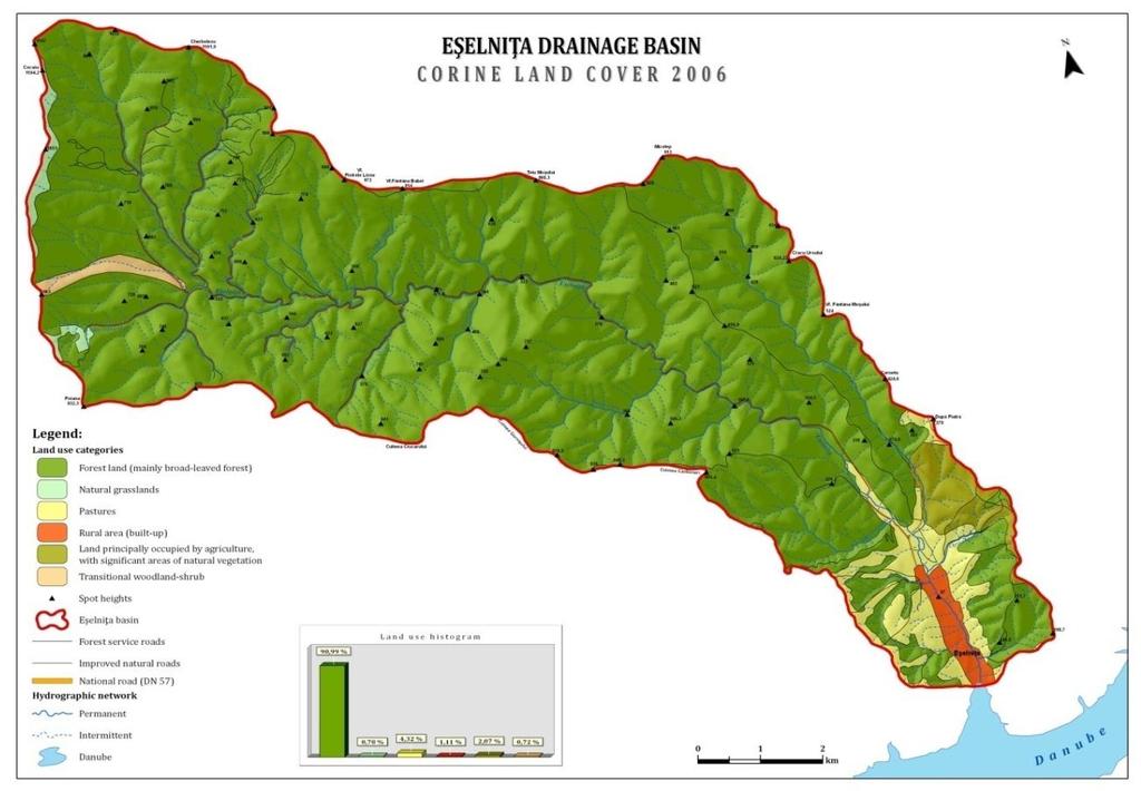
3 Cinq Continents Volume 1, Numéro 3, 2011, p GENERAL ASPECTS Eşelniţa drainage basin ( Figure 1) collects its water from a reception area of 77 square km by means of omonymous main collector arising from Almãjului Mountains, below Svinecea Mare peak, at an altitude of 1080 m. After the length of a main water course of 26 km, within the inferior segment, at the confluence of Eşelniţa river with Danube, there is a gulf where in accumulation processes act as a result of increasing of basis level. The change of the initial basis level has occurred as a result of forming the Iron Gates storage lakes, so that the altitude of the river mouth of Eşelniţa river is 64 m, in accordance with the normal level of lake s retention. As a result of mechanical treatment of water within hydro-electric plant, the altitude from the river mouth of Eşelniţa river, may vary, although in general is lies between m. The basin present a 5 th degree hydrographic network according to Horton-Strahler ranking system, tributary to Danube by means of Eşelniţa main collector. Developed under a mountain relief, the basin presents a multistage arrangement between the maximum altitude of 1107 m and the minimal altitude of 64
4 D. VLAD m, at the confluence with Danube, therefore having a level difference of 1043 m. The value of the level difference between the spring, located at 1080 m and the river mouth located at 64 m, is 1016 m. The geological components within Eşelniţa basin belong to Danube Field, having a crystalline bed consisting in crystalline schist represented by crystalline of Poiana Mraconiei, crystalline of Neamţu and crystalline of Corbu, eruptive rocks represented by two granitoidic massifs with intrusive character, inferior Paleozoic age: granite body of Cherbelezu having a northern development within the basin and granite body of Ogradena [1]. The sedimentation formations arranged on the crystalline bed do not cover a major surface, as in the north-western area of the basin there may be found formations belonging to inferior Jurassic (conglomerates, sandstones, argillaceous schist and coals) and in southern area of the basin there are major sedimentary deposits belonging to Neogene (marl, gravel, organogene limestone) and Quaternary (gravel and sands). 2. DATA AND METHODS The identification of various categories of use of land located within Eşelniţa drainage basin has been made on the basis of data collected from European Environment Agency by accessing Corine Land Cover representing a set of reference European data for the way of covering the land. Therefore, there have been used data collected from Corine Land Cover, upon the level of year 2006, as they are the most recent data accessible to public. In this way, there was possible the identification of surfaces differently used, the comparison of the taken over data with the field collected data and the evaluation of the human impact or human pressure on the natural territory within the drainage basin by using some quantitative indexes. 3. LAND USE The categories of using the land located within Eşelniţa drainage basin (Figure 2) are characterized by high share of surfaces of forests to the detriment of predominant agricultural land (Figure 3). Therefore, within Eşelniţa drainage basin, the surface of forestry land is hectares, a major part being covered by deciduous forests (lime, chestnut, oak, hornbeam, beech) and sporadically it may be covered by coniferous forests (spruce, fir) only at altitudes starting from 600 m up to 1107 m, the maximum altitude within the drainage basin and in case of surfaces belonging to predominant agricultural land with natural vegetation, their surface is only hectares. [247]


5 Cinq Continents Volume 1, Numéro 3, 2011, p
6 D. VLAD The share of the two surfaces as well as of the other categories of use of land located within Eşelniţa drainage basin may be seen in Table 1: Land use categories Surface ( hectares ) The share of ( % ) Forest land ( mainly broad % leaved forest ) Pastures % Land principally occupied by % agriculture, with significant areas of natural vegetation Natural grasslands % Transitional woodland - shrub % Rural area ( built - up ) % Because of human pressure, the evaluation of land artificialization degree within Eşelniţa drainage basin may be made only by suing some formulas with quantitative indexes using data regarding the use of land and the population located within analyzed area. One of these indexes is the Naturality index In = Sp / St, representing the ratio between the surface covered by forests ( Sp ) and the total surface ( St ) of analyzed space. In case of Eşelniţa drainage basin, upon the level of year 2006, the naturality index for establishing the share of land covered by forests within analyzed territory results from using the formula: In = Sp/St = hectares / 77 sq. km = sq. km / 77 sq. km = 0.9 kmp. So, the value is 0.9 sq. km providing the basin with the character of landscape with ecological equilibrium closed to the natural one (Table 2). The index value of naturality Type of landscape >0.6 With ecological equilibrium close to the natural one With relatively stable ecological equilibrium With weak ecological equilibrium damaged Landscape at the threshold of ecological equilibrium With strong ecological equilibrium damaged <0.1 With very strong ecological equilibrium affected [249]
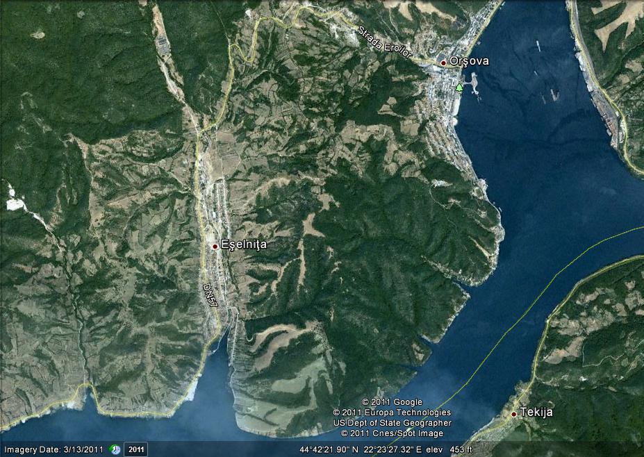
7 Cinq Continents Volume 1, Numéro 3, 2011, p The value resulted from using this formula is confirmed by predominant large surface covered with forests within the basin, with the approximately partial exception of inferior sector having predominantly agricultural surfaces identified closed to Eşelniţa locality. Another index proving the intensity of human impact on an analyzed surfaces is the Human pressure ( P ) which may be established by using the following formula: P = S/N [4], representing the ratio between the surface of the respective mode of using the land ( S ) and the number of inhabitants living within analyzed surface ( P ). The use of this formula for establishing the human impact on the forest land indicates a small value of 2.7 hectares / inhabitants, therefore a human pressure without major changes on territory located within Eşelniţa drainage basin: P = S/N = hectares / 3069 inhabitants = 2.27 hectares / inhabitants (for woodlands). The evaluation of human pressure on predominantly agricultural land located within Eselnita drainage basin may be also established using the same formula: P = S/N = hectares / 3069 inhabitants = 0.05 hectares / inhabitants ( land predominantly agricultural). The comparative situation regarding the share of predominantly agricultural land located within the southern part of basin and forest land indicates the dominating forest character of Eşelniţa drainage basin. For evaluating the environment transformation degree of the land located within the basin, there is used the Environmental transformation index [5], resulting from the ratio between the total surface covered by forest land together with natural grazing lands and the built in surface, in this case being rural (built in) space of Eşelniţa locality. According to the calculation formula of this index I tr.e. = S ( Woodland + meadows ) / S ( built area ) which in case of Eşelniţa basin is applied as follows: I tr. e. = / = hectares. The obtained value indicates the high share of land covered by forests and natural grazing lands in relation with the built in surface of the singular locality located within the basin and implicitly a reduced transformation of the territory within Eşelniţa basin. 4. CONCLUSIONS Within Eşelniţa basin having surfaces with various categories of use of land, there is noticed the high share of forest land with predominant deciduous forests in relation with the surface of the basin or with the surface held by rural (built in) space of the singular locality located within the basin, establishes a reduced impact on natural environment. Also in case of the other calculated indexes regarding the impact of inhabitants of environmental transformation on the geographic environment
8 D. VLAD within the basin, there are not established any major and damaging interventions. Under these conditions, there may be asserted that Eşelniţa basin has a predominant forest character. 5. ACKNOULEDGEMENTS Invest in human resources! This work was supported by project: POSDRU/88/1.5/S/61150 Doctoral Studies in the field of life and earth sciences, project co-financed through Sectorial Operational Program for the Development of Human Resources from European Social Fund. 6. REFERENCES [1] MUTIHAC V., IONESI L. Geologia României. Editura Tehnicã, 1974; Bucureşti. [2] *** Agenţia Europeană de Mediu, baza de date Corine Land Cover. anul [3] *** Imagine satelitara preluata prin intermediul aplicatiei Google Earth, [4] COMĂNESCU L. Bazinul morfohidrografic Casimcea. Studiu geomorphologic. Editura Universităţii, 2004; Bucureşti. [5] PĂTRU I. Culoarul Rucăr Bran. Studiu de geografie fizică. Editura Universităţii, 2001; Bucureşti. [251]
Riscuri şi Catastrofe
 RISCURI ŞI CATASTROFE, NR. X, VOL. 9, NR. 2/2011 BARCĂU RIVER HYDROLOGICAL CHARACTERIZATION DURING THE 1993-2009 PERIOD N. JOSAN 1, D. DUME 2, SIMONA GABRIELA ANDRIŞCA 2 ABSTRACT. Barcau River Hydrological
SIGNIFICANT DIFFUSED POLLUTION SOURCES IN SOILS AND WATERS OF BEGA HYDROGRAPHIC BASIN
 SIGNIFICANT DIFFUSED POLLUTION SOURCES IN SOILS AND WATERS OF BEGA HYDROGRAPHIC BASIN PRINCIPALELE SURSE DIFUZE DE POLUARE ALE SOLURILOR SI APELOR DIN BAZINUL HIDROGRAFIC BEGA Ioana A. COSTESCU Politechnic
Forests in Serbia as the Factor of Environment Protection in the Conditions of Global Climate Changes
 Forests in Serbia as the Factor of Environment Protection in the Conditions of Global Climate Changes Stanimir Kostadinov Belgrade University, Faculty of Forestry Kneza Višeslava 1, 11030 Belgrade, Serbia
PRELIMINARY ANALYSIS ON SOME PHYSICO-CHEMICAL RIVERS WATER FEATURES IN PRICOP-HUTA CERTEZE AND TISA SUPERIOARĂ PROTECTED AREAS
 PRELIMINARY ANALYSIS ON SOME PHYSICO-CHEMICAL RIVERS WATER FEATURES IN PRICOP-HUTA CERTEZE AND TISA SUPERIOARĂ PROTECTED AREAS R. BĂTINAŞ 1, GH. ŞERBAN 2, A. SABĂU 1, S. RAFAN 1 ABSTRACT. - Preliminary
Issues of forestry fund administration by forestry department Reşiţa in the period
 Volume 15(4), 66-69, 2011 JOURNAL of Horticulture, Forestry and Biotechnology Issues of forestry fund administration by forestry department Reşiţa in the period 2001-2010 Chisăliţă I. 1, Solomonesc A.
MANAGEMENTUL PROGRAMELOR EUROPENE CU IMPACT ASUPRA SECTORULUI ENERGETIC AL ROMÂNIEI
 MANAGEMENT OF EUROPEAN PROGRAMS WITH IMPACT ON THE ENERGY ROMANIAN SECTOR MANAGEMENTUL PROGRAMELOR EUROPENE CU IMPACT ASUPRA SECTORULUI ENERGETIC AL ROMÂNIEI Irina POPA Ph.D. Student, Bucharest Academy
CONSIDERATIONS ON THE ANTHROPIC ROMANIAN LAKES AND THEIR IMPACT ON THE ENVIRONMENT
 Lakes, reservoirs and ponds, vol. 1-2: 127-131, December 8 Romanian Limnogeographical Association CONSIDERATIONS ON THE ANTHROPIC ROMANIAN LAKES AND THEIR IMPACT ON THE ENVIRONMENT Liliana ZAHARIA, Ileana
CARACTERISTICS OF THE LOWER DANUBE WATER BODIES BETWEEN PORTILE DE FIER (IRON GATES) AND ISACCEA
 AND ISACCEA") Lakes, reservoirs and ponds, vol. 4(2): 109-118, 2010 Romanian Limnogeographical Association CARACTERISTICS OF THE LOWER DANUBE WATER BODIES BETWEEN PORTILE DE FIER (IRON GATES) AND ISACCEA Elena ŢUCHIU
Lakes, reservoirs and ponds, vol. 4(2): 109-118, 2010 Romanian Limnogeographical Association CARACTERISTICS OF THE LOWER DANUBE WATER BODIES BETWEEN PORTILE DE FIER (IRON GATES) AND ISACCEA Elena ŢUCHIU
Impact of various parameters on the energy consumption of residential buildings
 Impact of various parameters on the energy consumption of residential buildings Rémi LAPEZE University of Savoie Mont Blanc Chambéry, France Email : remi.lapeze@gmail.com Saifdine BELYMAM University of
Research Journal of Agricultural Science, 45 (2), Oprea RADU
, Oprea RADU") WATER EXCESS DRAINAGE DURING OPERATIONS ON AGRICULTURAL LAND FITTED WITH DRAINAGE-DRAINING WORKS IN THE CATCHMENT AREA OF MOLDOVA RIVER, SUCEAVA COUNTY Oprea RADU University of Agricultural Sciences and
WATER EXCESS DRAINAGE DURING OPERATIONS ON AGRICULTURAL LAND FITTED WITH DRAINAGE-DRAINING WORKS IN THE CATCHMENT AREA OF MOLDOVA RIVER, SUCEAVA COUNTY Oprea RADU University of Agricultural Sciences and
THE STATISTICAL ANALYSIS AND THE QUANTITATIVE ASSESSMENT OF ANNUAL MAXIMUM FLOWS RECORDED IN THE HYDROGRAPHICAL BASIN OF TIMI RIVER
 THE STATISTICAL ANALYSIS AND THE QUANTITATIVE ASSESSMENT OF ANNUAL MAXIMUM FLOWS RECORDED IN THE HYDROGRAPHICAL BASIN OF TIMI RIVER ANDREEA MIHAELA DOM NEANU 1 ABSTRACT. The statistical analysis and the
THE CHARACTERIZATION OF LIQUID DISCHARGE IN THE HYDROGRAPHIC NETWORK OF THE TINOASA CIUREA WATERSHED, IASI COUNTY
 THE CHARACTERIZATION OF LIQUID DISCHARGE IN THE HYDROGRAPHIC NETWORK OF THE TINOASA CIUREA WATERSHED, IASI COUNTY Claudiu PRICOP, Florian STĂTESCU Technical University Gheorghe Asachi of Iaşi, Faculty
ABIOTIC TYPOLOGY OF SURFACE WATER BODIES IN THE HYDROGRAPHIC BASIN OF THE ARIEŞ RIVER
 ROMANIAN REVIEW OF REGIONAL STUDIES, Volume VI, Number 2, 2010 ABIOTIC TYPOLOGY OF SURFACE WATER BODIES IN THE HYDROGRAPHIC BASIN OF THE ARIEŞ RIVER RĂZVAN-HORAłIU BĂTINAŞ 1, GHEORGHE ŞERBAN 2 ABSTRACT
CHARACTERISTICS OF THE FOREST FUND IN IASI COUNTY, WITH SPECIAL REFERENCE TO THE FOREST WARDS OF IASI AND CIUREA
 PRESENT ENVIRONMENT AND SUSTAINABLE DEVELOPMENT, NR. 3, 2009 CHARACTERISTICS OF THE FOREST FUND IN IASI COUNTY, WITH SPECIAL REFERENCE TO THE FOREST WARDS OF IASI AND CIUREA Angela Lupaşcu 1, Maria Onofrei
Methodology and criteria used to analyse and select reforestation projects
 Methodology and criteria used to analyse and select reforestation projects Version 03/ 28.03.2018 CONTENTS 1. Introduction... 2 2. Methodology, criteria and indicators... 3 2.1 General matters... 3 2.2
AAB BIOFLUX Advances in Agriculture & Botanics- International Journal of the Bioflux Society
 AAB BIOFLUX Advances in Agriculture & Botanics- International Journal of the Bioflux Society Spatial variability of coniferous species radial growth in Moldovita River Basin Nicolaie Plaiu University Ştefan
ASPECTS REGARDING THE FORESTRY PATTERN AND USE OF THE ALBA IULIA FORESTRY DEPARTMENT
 Analele UniversităŃii din Oradea Seria Geografie Year XXIII, no. 1/2013 (June), pp. 163-167 ISSN 1221-1273, E-ISSN 2065-3409 Article no. 231120-624 ASPECTS REGARDING THE FORESTRY PATTERN AND USE OF THE
The minimum flow in the upstream basin of the Timis River
 IOP Conference Series: Earth and Environmental Science The minimum flow in the upstream basin of the Timis River To cite this article: Niculae Iulian Teodorescu 28 IOP Conf. Ser.: Earth Environ. Sci. 4
Contact zones of the Amur River basin: Landscape structure, Land cover and Anthropogenic influence
 Contact zones of the Amur River basin: Landscape structure, Land cover and Anthropogenic influence Ermoshin Victor V. Pacific Geographical Institute FEB RAS Vladivostok, Russia Finance support by ISTC
SPATIAL DIMENSION OF PIG AND POULTRY SUBSECTORS DEVELOPMENT IN ROMANIA
 Lucian LUCA Institute of Agricultural Economics, Romanian Academy, Bucharest luca@eadr.ro SPATIAL DIMENSION OF PIG AND POULTRY SUBSECTORS DEVELOPMENT IN ROMANIA ABSTRACT The paper investigates the evolution
Extensive Ecoforest Map of Northern Continuous Boreal Forest, Québec, Canada
 Extensive Ecoforest Map of Northern Continuous Boreal Forest, Québec, Canada A. Robitaille¹, A. Leboeuf¹, J.-P. Létourneau¹, J.-P. Saucier¹ and É. Vaillancourt¹ 1. Ministère des Ressources naturelles et
DISTRIBUTION AND ANNUAL REGIME OF THERMO-HYGROMETRIC INDEX IN THE WEST OF CURVATURE CARPATHIANS
 DISTRIBUTION AND ANNUAL REGIME OF THERMO-HYGROMETRIC INDEX IN THE WEST OF CURVATURE CARPATHIANS ELENA GRIGORE 1, LUMINIŢA SĂFTOIU 2 Abstract Western region of Curvature Carpathians is recognized as a tourist
THE AGRICULTURAL SYSTEM IN THE NOVACI LOCALITY, GORJ COUNTY AREA
 THE AGRICULTURAL SYSTEM IN THE NOVACI LOCALITY, GORJ COUNTY AREA T.FLORESCU, A.OKROS, L.NIȚĂ USAMVB REGELE MIHAI I AL ROMÂNIEI DIN TIMIȘOARA tibiflorescu15@yahoo.comlucian_nt@yahoo.com Abstract. At the
THE POSSIBILITY ARRANGEMENT OF MICROHYDROPOWER ON FINIŞ VALLEY COMPLETED IN ORDER TO PRODUCE CLEAN ENERGY
 THE POSSIBILITY ARRANGEMENT OF MICROHYDROPOWER ON FINIŞ VALLEY COMPLETED IN ORDER TO PRODUCE CLEAN ENERGY Călin Ioan Iovan University from Oradea, Faculty of Environmental Protection, 26 Gen. Magheru St.,
Watersheds. A river is the report card for its watershed. Alan Levere. Arizona Water Issues 2010 The University of Arizona HWR203 1
 Watersheds A river is the report card for its watershed. Alan Levere 1 What separates watersheds? How do you identify watershed boundaries? Drainage Divides River Networks boto.ocean.washington.edu/gifs/purus.gif
ENVIRONMENTAL POLLUTION DUE TO MINING CONCERNING THE FORMER GRAVEL PITS FROM ALEȘD- RICIU VALLEY REGION
 Analele Universităţii din Oradea, Fascicula Protecţia Mediului Vol. XXVI, 2016 ENVIRONMENTAL POLLUTION DUE TO MINING CONCERNING THE FORMER GRAVEL PITS FROM ALEȘD- RICIU VALLEY REGION *Sole proprietorship
WEATHER FACTORS, WATER RESOURCES AND THE NEED OF IRRIGATION. CASE STUDY BRĂILA COUNTY
 Elisabeta ROŞU Institute of Agricultural Economics, Romanian Academy, Bucharest betty_rosu@yahoo.com WEATHER FACTORS, WATER RESOURCES AND THE NEED OF IRRIGATION. CASE STUDY BRĂILA COUNTY ABSTRACT Climate
Forward GB/T
 GB/T 18005-1999 Forward Rich forest landscape resources in China have great value for forest tourism. Forest parks, as a major form for forest tourism, have got significant progress in their development
STUDIU COMPARATIV PRIVIND COSTURILE DE FABRICATIE A UNEI PIESE REPREZENTATIVE
 STUDIU COMPARATIV PRIVIND COSTURILE DE FABRICATIE A UNEI PIESE REPREZENTATIVE Gabriela Georgeta NICHITA Universitatea din Oradea, e-mail: gnichita@uoradea.ro Abstract: By comparative study in this paper,
USING SPATIAL DATABASES FOR OPTIMIZATION OF THE FOREST-OWNERSHIP ACTIVITIES
 Analele Universităţii din Oradea, Fascicula Protecţia Mediului Vol. XXV, 2015 USING SPATIAL DATABASES FOR OPTIMIZATION OF THE FOREST-OWNERSHIP ACTIVITIES 299 Bodog Marinela*, Crainic Ghiţă Cristian* *University
Disaggregated Financial-Accounting Information for Users (Concrete Measures for Improving International Financial Reporting)
") EUROPEAN ACADEMIC RESEARCH Vol. III, Issue 11/ February 2016 ISSN 2286-4822 www.euacademic.org Impact Factor: 3.4546 (UIF) DRJI Value: 5.9 (B+) Disaggregated Financial-Accounting Information for Users
EUROPEAN ACADEMIC RESEARCH Vol. III, Issue 11/ February 2016 ISSN 2286-4822 www.euacademic.org Impact Factor: 3.4546 (UIF) DRJI Value: 5.9 (B+) Disaggregated Financial-Accounting Information for Users
WOOD FUNGI POTENTIAL DESTABILISATION FACTORS OF FOREST ECOSYSTEM. CASE STUDY
 ANALELE Universităţii Ştefan cel Mare Suceava SECŢIUNEA GEOGRAFIE ANUL XVIII - 2009 WOOD FUNGI POTENTIAL DESTABILISATION FACTORS OF FOREST ECOSYSTEM. CASE STUDY Key words: woods fungi, attack, economic
DISTRIBUTION OF FROST CRACKS LENGTH IN RELATION TO COMPASS POINTS AND BIOLOGICAL ORIGIN OF TURKEY OAK WITHIN BOBOSTEA FOREST (COUNTY OF BIHOR)
") Analele Universităţii din Oradea, Fascicula Protecţia Mediului Vol. XXIII, 2014 DISTRIBUTION OF FROST CRACKS LENGTH IN RELATION TO COMPASS POINTS AND BIOLOGICAL ORIGIN OF TURKEY OAK WITHIN BOBOSTEA FOREST
Analele Universităţii din Oradea, Fascicula Protecţia Mediului Vol. XXIII, 2014 DISTRIBUTION OF FROST CRACKS LENGTH IN RELATION TO COMPASS POINTS AND BIOLOGICAL ORIGIN OF TURKEY OAK WITHIN BOBOSTEA FOREST
STUDIES REGARDING THE EVOLUTION OF AGRICULTURE ASSOCIATIONS IN IAŞI COUNTY FOR DESIGNING VIABLE FARMS
 EVOLUTION OF AGRICULTURE ASSOCIATIONS IN IASI COUNTY FOR DESIGNING VIABLE FARMS Cercetări Agronomice în Moldova Vol. XLIII, No. 3 (143) / 2010 STUDIES REGARDING THE EVOLUTION OF AGRICULTURE ASSOCIATIONS
Ministry of Agriculture and Rural Development. Fight against soil erosion and watershed management
 Ministry of Agriculture and Rural Development Fight against soil erosion and watershed management - The activity of watershed management in Romania: - is a very close to the forestry field - it contributes
RESEARCH FOR ESTABLISHING THE OPTIMUM SOIL TILLAGE OF THE PRELUVOSOIL FROM ORADEA
 NATURAL RESOURCES AND SUSTAINABLE DEVELOPMENT, 2015 RESEARCH FOR ESTABLISHING THE OPTIMUM SOIL TILLAGE OF THE PRELUVOSOIL FROM ORADEA Brejea Radu*, Şandor Maria, Domuța Cornel *University of Oradea, Faculty
FIELD TRIP + ON SITE DISCUSSION GUIDE
 FIELD TRIP + ON SITE DISCUSSION GUIDE Integrating Scientific Knowledge in Mixed Forests EuMIXFOR Final Conference, Prague, October 5 th 7 th COST Action FP 1206 The guide was prepared by Jiří Remeš Department
NOWADAYS SITUATION OF DRAINAGE SYSTEMS IN THE MOLDOVA RIVER WATERSHED
 NOWADAYS SITUATION OF DRAINAGE SYSTEMS IN THE MOLDOVA RIVER WATERSHED Minodora AILENEI (RADU), Oprea RADU, Daniel BUCUR Ion Ionescu de la Brad University of Agricultural Sciences and Veterinary Medicine
THE TUUL RIVER WATER RESOURCES CHANGES AND WATER USE IN ULAANBAATAR CITY, MONGOLIA
 THE TUUL RIVER WATER RESOURCES CHANGES AND WATER USE IN ULAANBAATAR CITY, MONGOLIA ABSTRACT N.Batnasan Institute of Geography, Mongolian Academy of Sciences, P.O.Box-664, Ulaanbaatar-24, Mongolia, e-mail:
Nehalem River Watershed Assessment 1
 Nehalem River Watershed Assessment 1 1.0 Introduction Purpose Watershed assessment is a process for evaluating how well a watershed is working. The purpose of this assessment was to determine how natural
THE INFLUENCE OF THE CROP SYSTEM ON SOIL AND YIELD LOSSES IN THE CONDITIONS OF THE EROSIONED SOILS FROM BIHOR
 NATURAL RESOURCES AND SUSTAINABLE DEVELOPMENT, 2012 THE INFLUENCE OF THE CROP SYSTEM ON SOIL AND YIELD LOSSES IN THE CONDITIONS OF THE EROSIONED SOILS FROM BIHOR Brejea Radu*, Domuta Cornel, Sandor Maria,
CREATION OF GIS FOR AMUR RIVER BASIN: THE BASIC
 CREATION OF GIS FOR AMUR RIVER BASIN: THE BASIC GEOGRAPHICAL INFORMATION YERMOSHIN V.V., GANZEY S.S., MURZIN A.V., MISHINA N.V. AND KUDRYAVTZEVA E. P. Pacific Institute of Geography FEB RAS, Vladivostok,
Similkameen Watershed
 Similkameen Watershed Largest Watershed in the Okanagan system contributing 75% of flow of Okanagan River Drained by the Similkameen River Within the political boundary of Regional District Okanagan Similkameen
RESEARCHES CONCERNING THE TURKEY OAK FROST- CRACK PRESENCE, IN TURKEY OAK STANDS FROM BOBOSTEA FOREST
 Analele Universităţii din Oradea, Fascicula: Protecţia Mediului, Vol. XIII, 2008 RESEARCHES CONCERNING THE TURKEY OAK FROST- CRACK PRESENCE, IN TURKEY OAK STANDS FROM BOBOSTEA FOREST Szilard Bartha* *University
MANAGEMENTUL RESURSELOR UMANE ÎN SECTORUL PUBLIC - STUDIU ASUPRA SISTEMULUI PUBLIC DE SĂNĂTATE DIN ROMÂNIA
 HUMAN RESOURCES MANAGEMENT IN THE PUBLIC SECTOR: A STUDY OF THE PUBLIC HEALTH SYSTEM IN ROMANIA MANAGEMENTUL RESURSELOR UMANE ÎN SECTORUL PUBLIC - STUDIU ASUPRA SISTEMULUI PUBLIC DE SĂNĂTATE DIN ROMÂNIA
ECO-URBANIZAREA: O PROBLEMĂ PRIORITARĂ ÎN ADMINISTRAŢIA PUBLICĂ
 ECO-URBANIZAREA: O PROBLEMĂ PRIORITARĂ ÎN ADMINISTRAŢIA PUBLICĂ ECO-URBANIZATION: A PRIORITARY PROBLEM IN PUBLIC ADMINISTRATION Madalina DOCIU Ph.D. Student, Faculty of Agrifood and Environment Economics,
HABITAT VARIABLES ASSOCIATED WITH WOLF (CANIS LUPUS L.) DISTRIBUTION AND ABUNDANCE IN BULGARIA. Abstract. Introduction. Materials and Methods
 DISTRIBUTION AND ABUNDANCE IN BULGARIA. Abstract. Introduction. Materials and Methods") 262 Bulgarian Journal of Agricultural Science, 19 (2) 213, 262 266 Agricultural Academy HABITAT VARIABLES ASSOCIATED WITH WOLF (CANIS LUPUS L.) DISTRIBUTION AND ABUNDANCE IN BULGARIA D. ZLATANOVA * and
262 Bulgarian Journal of Agricultural Science, 19 (2) 213, 262 266 Agricultural Academy HABITAT VARIABLES ASSOCIATED WITH WOLF (CANIS LUPUS L.) DISTRIBUTION AND ABUNDANCE IN BULGARIA D. ZLATANOVA * and
Hydrological Observatory description
 Athens, Greece Location The Greater Athens Area hydrological observatory is located in the periphery of Attica, in the south of the country, and covers the part of the greater Athens area, which extends
FLOOD ANALYSIS USING HYDROLOGICAL MODELING. CASE STUDY THE FLOOD IN THE UPPER CATCHMENT OF RIVER GERU, GALAŢI COUNTY, ROMANIA
 DOI 10.1515/pesd-2015-0030 PESD, VOL. 9, no. 2, 2015 FLOOD ANALYSIS USING HYDROLOGICAL MODELING. CASE STUDY THE FLOOD IN THE UPPER CATCHMENT OF RIVER GERU, GALAŢI COUNTY, ROMANIA Isabela Balan 1, Loredana
Ecosystems on land are grouped into biomes primarily based on the plant communities within them.
 Section 2: Ecosystems on land are grouped into biomes primarily based on the plant communities within them. K What I Know W What I Want to Find Out L What I Learned Essential Questions How is latitude
SHAKING TABLE TESTS OF A BASE ISOLATED STRUCTURE WITH MULTI-STAGE SYSTEM
 BULETINUL INSTITUTULUI POLITEHNIC DIN IAŞI Publicat de Universitatea Tehnică Gheorghe Asachi din Iaşi Tomul LXI (LXV), Fasc. 3, 2015 Secţia CONSTRUCŢII. ARHITECTURĂ SHAKING TABLE TESTS OF A BASE ISOLATED
Hydrological Observatory description
 RIVER PÄRNU, ESTONIA Location The Pärnu river catchment area is situated in Western Estonia and drains 6,900 km² to the Bay of Pärnu, which is northern part of the Gulf of Riga. It is one of the longest
Tendencies and evolution in the development of the rural space in Romania
 ORIGINAL SCIENTIFIC PAPER Tendencies and evolution in the development of the rural space in Romania Pompilica Iagăru 1, Romulus Iagăru 2, Jenica Călina 3, Aurel Călina 3 1 Faculty of Agricultural Sciences,
Annals. Food Science and Technology 2010 CAUSES AND EFFECTS OF NATURAL ENVIRONMENT DEGRADATION IN THE HYDROGRAPHIC BASIN OF RIVER NEAJLOV
 CAUSES AND EFFECTS OF NATURAL ENVIRONMENT DEGRADATION IN THE HYDROGRAPHIC BASIN OF RIVER NEAJLOV Luminita Doinea 1, Tatiana Diaconu 2 Florin Maracineanu 1 1 University of Agronomical Sciences and Veterinary
Sustainable Development and Implications of Rural Tourism in the Development of Călăraşi County
 Centre for Research on Settlements and Urbanism Journal of Settlements and Spatial Planning J o u r n a l h o m e p a g e: http://jssp.reviste.ubbcluj.ro Sustainable Development and Implications of Rural
FOUNDATION OF COMMUNICATION STRATEGY FOR NORTHERN DOBROGEA TOURISTIC DESTINATION
 FOUNDATION OF COMMUNICATION STRATEGY FOR NORTHERN DOBROGEA TOURISTIC DESTINATION Phd. Student Maria Roxana COSMA 1, Phd. Professor Alexandru NEGREA 2, Ph.D., Assistant Professor Pavel STANCIU 3 Abstract
Research Journal of Agricultural Science, 47 (3), G. SPÂRCHEZ, O. N. APARASCHIVEI, Raluca-Elena ENESCU
, G. SPÂRCHEZ, O. N. APARASCHIVEI, Raluca-Elena ENESCU") QUANTITATIVE DETERMINATION OF THE MAIN ECOLOGICAL INDICATORS, USED IN DETERMNING QUALITY OF MOUNTAIN AND PRE- MOUNTAIN EUROPEAN BEECH FOREST SITES, SITUATED ON EUTRIC CAMBISOLS FROM BARAOLT AND BODOC MOUNTAINS
QUANTITATIVE DETERMINATION OF THE MAIN ECOLOGICAL INDICATORS, USED IN DETERMNING QUALITY OF MOUNTAIN AND PRE- MOUNTAIN EUROPEAN BEECH FOREST SITES, SITUATED ON EUTRIC CAMBISOLS FROM BARAOLT AND BODOC MOUNTAINS
Chapter 2: Conditions in the Spring Lake Watershed related to Stormwater Pollution
 Chapter 2: Conditions in the Spring Lake Watershed related to Stormwater Pollution To identify the primary causes and consequences of stormwater discharges to Spring Lake and its adjoining waterbodies,
THE MAP OF INDOOR RADON CONCENTRATIONS IN NORTHEASTERN ROMANIA
 THE JOURNAL OF PREVENTIVE MEDICINE 2002; (3): -15 THE MAP OF INDOOR RADON CONCENTRATIONS IN NORTHEASTERN ROMANIA C. Grecea, Olga Iacob Institute of Public Health Iaşi Abstract. The radon concentrations
MT - GEOGRAPHY - (73) - PRELIM - I : PAPER - 3
 - PRELIM - I : PAPER - 3") MT 2019 1100 Seat No. MT - GEOGRAPHY - (73) - PRELIM - I : PAPER - 3 Time : 2 Hours (Pages 5) Max. Marks : 0 Q.1. Select the correct option and rewrite the sentence : (1) Both India and Brazil have type
MT 2019 1100 Seat No. MT - GEOGRAPHY - (73) - PRELIM - I : PAPER - 3 Time : 2 Hours (Pages 5) Max. Marks : 0 Q.1. Select the correct option and rewrite the sentence : (1) Both India and Brazil have type
Emil Vergilius MARINESCU, Ștefan STĂNESCU, Dumitrel-Victor TIȚA
 THE HIERARCHIZATION OF THE IMPORTANCE OF CONSULTANCY CONCERNING THE MAIN TECHNICAL AND ECONOMIC ISSUES AT THE LEVEL OF THE AGRICULTURAL EXPLOITATIONS IN OLT COUNTY Emil Vergilius MARINESCU, Ștefan STĂNESCU,
ANALYSIS OF QUALITY AND ECONOMIC INDICATORS IN STEEL MAKING INVOLVING SECONDARY MATERIALS RECIRCULATION
 U.P.B. Sci. Bull., Series B, Vol. 68, No. 2, 2006 ANALYSIS OF QUALITY AND ECONOMIC INDICATORS IN STEEL MAKING INVOLVING SECONDARY MATERIALS RECIRCULATION Mirela SOHACIU, GH. IORGA, A.NICOLAE În lucrare
Environmental and Climate change in Mongolia
 Environmental and Climate change in Mongolia D. Azzaya Institute of Meteorology and Hydrology (IMH), Mongolia Juulchny gudamj-5, Ulaanbaatar-46, 210646, Mongolia A.Khaulenbek Desertification study center,
Land Cover / Land Use & Digital Elevation Maps. These are required for almost all coastal products involving the terrestrial side.
 Land Cover / Land Use & Digital Elevation Maps These are required for almost all coastal products involving the terrestrial side. Example Issues to be Addressed Risk and vulnerability assessment Urbanization
A regional travel model for predicting the number of visitors in forests: application to the Walloon region. Vincent Colson, Philippe Lejeune
 A regional travel model for predicting the number of visitors in forests: Vincent Colson, Philippe Lejeune Abstract The Walloon forests are visited by local people and tourists but the importance of forest
THE USE OF AGRICULTURAL LANDS IN NORTHERN MOLDOVA PLATEAU
 DOI 10.1515/pesd-2015-0026 PESD, VOL. 9, no. 2, 2015 THE USE OF AGRICULTURAL LANDS IN NORTHERN MOLDOVA PLATEAU Victor Capcelea 1, Valentin Sofroni 2 Key words: agricultural lands, arable lands, pastures
ACTA TECHNICA NAPOCENSIS
 547 TECHNICAL UNIVERSITY OF CLUJ-NAPOCA ACTA TECHNICA NAPOCENSIS Series: Applied Mathematics, Mechanics, and Engineering Vol. 57, Issue IV, November, 2014 THE NOISE LEVEL ANALYZE RESULTED DUE TO FORESTRY
Cristian Paltineanu 1, Emil Chitu 2 and Emilia Mateescu 3
 TENDINŢE NOI PRIVIND EVAPOTRANSPIRAŢIA ŞI CERINŢELE PENTRU APA DE IRIGARE A UNOR CULTURI HORTICOLE ÎN PRIMUL DECENIU AL SECOLULUI I ÎN SUDUL ROMÂNIEI NEW TRENDS FOR CROP EVAPOTRANSPIRATION AND IRRIGATION
ECOPEDOLOGICAL INTERPRETATION OF SOILS FROM AGRICULTURAL ECOSYSTEMS OF LOWER PRUT RIVER MEADOW
 ECOPEDOLOGICAL INTERPRETATION OF SOILS FROM AGRICULTURAL ECOSYSTEMS OF LOWER PRUT RIVER MEADOW Maria Contoman 1, Mariea Murariu 2, Mirela Elena Manea 2 ABSTRACT A detailed chracterization of agricultural
Contributions to the presentation of the Caraș-Severin County by modern methods
 Volume 21(3), 33-38, 2017 JOURNAL of Horticulture, Forestry and Biotechnology www.journal-hfb.usab-tm.ro Contributions to the presentation of the Caraș-Severin County by modern methods Curița Ileana Florina
Forest plantations on the tailing dumps from Moldova Nouă periurban forest
 Volume 19(1), 216-220, 2015 JOURNAL of Horticulture, Forestry and Biotechnology www.journal-hfb.usab-tm.ro Forest plantations on the tailing dumps from Moldova Nouă periurban forest Cântar I. C. 1* 1 Forest
PROJECT INDICATORS ESSENTIAL FACTOR IN THE DESIGN OF THE PROJECT PROPOSALS OF THE STRUCTURAL FUNDS
 Annals of the Academy of Romanian Scientists Series on Engineering Sciences ISSN 2066-8570 Volume 3, Number 1/2011 93 PROJECT INDICATORS ESSENTIAL FACTOR IN THE DESIGN OF THE PROJECT PROPOSALS OF THE STRUCTURAL
The analysis of the spatial distribution of arboretum and its adaption to a series of stationary factors
 Volume 16(4), 85-90, 2012 JOURNAL of Horticulture, Forestry and Biotechnology www.journal-hfb.usab-tm.ro The analysis of the spatial distribution of arboretum and its adaption to a series of stationary
W atershed Number:
 %g 2 8 %g 2 8 (Lower) Watershed W atershed Number: 522 Location Map %g Fin castle %g2 6 %g2 7 (Lower) Watershed Lee Bea ttyville %g %g 52 %g %g 5 2 %g 5 2 %g 7 8 %g 7 8 %g2 69 %g 5 2 %g 5 %g 52 %g Jackso
SCIENTIFIC PRINCIPLES FOR THE ECOLOGICAL RECONSTRUCTION OF THE NORWAY SPRUCE STANDS AFFECTED BY DEER
 SCIENTIFIC PRINCIPLES FOR THE ECOLOGICAL RECONSTRUCTION OF THE NORWAY SPRUCE STANDS AFFECTED BY DEER RADU VLAD a a Forest Research and Management Institute, Research Station for Norway Spruce Silviculture,
AAB BIOFLUX Advances in Agriculture & Botanics- International Journal of the Bioflux Society
 AAB BIOFLUX Advances in Agriculture & Botanics- International Journal of the Bioflux Society The natural factors and the risk of fire in the forests of Suceava county - short technical review Ion Burlui
STUDY OF NUTRIENTS AND SOME TOXIC AND SPECIFIC POLLUTANTS FROM CRIŞUL REPEDE RIVER
 Analele Universităţii din Oradea, Fascicula Protecţia Mediului Vol. XVII, 2011 STUDY OF NUTRIENTS AND SOME TOXIC AND SPECIFIC POLLUTANTS FROM CRIŞUL REPEDE RIVER Gîtea Daniela*, Iovan Vasile*, Paşca Bianca*,
WATER FROM THE CLOUDS
 WATER FROM THE CLOUDS 814 mm per year on land or 110 000 km 3 56% is evapotranspirated by forests and natural landscapes 5% is evapotranspirated by rainfed agriculture 39% available for human uses (irrigation,
THE INFLUENCE OF SOME COMPOSITION FACTORS ON THE BEHAVIOR OF MICRO-CONCRETES SUBJECTED TO MAGNESIAN AGRESSIVITY
 BULETINUL INSTITUTULUI POLITEHNIC DIN IAŞI Publicat de Universitatea Tehnică,,Gheorghe Asachi din Iaşi Tomul LIV (LVIII), Fasc. 3, 2008 Sectia CONSTRUCŢII. ARHITECTURĂ THE INFLUENCE OF SOME COMPOSITION
River Talk Patterns. Student Copy Page PART I (1 of 1) 3. Human nervous system. Waters and drainage patterns. Road system.
 3. Human nervous system. Waters and drainage patterns. Road system.") River Talk Patterns Student Copy Page PART I (1 of 1) 3 Human nervous system photo credit: Hemera Thinkstock Photos Waters and drainage patterns photo credit: Comstock Getty Images Road system photo credit:
River Talk Patterns Student Copy Page PART I (1 of 1) 3 Human nervous system photo credit: Hemera Thinkstock Photos Waters and drainage patterns photo credit: Comstock Getty Images Road system photo credit:
Case Tejo/Tajo/Tagus: The Spanish perspective
 Case Tejo/Tajo/Tagus: The Spanish perspective Santiago Beguería-Portugués Sergio M. Vicente-Serrano Pyrenean Institute of Ecology Spanish Council of Scientific Research Campus de Aula Dei, P.O. Box 22,
CARPIVIA project support for Working group objectives
 CARPIVIA project support for Working group objectives Saskia Werners, Wageningen UR, David Nieuwenhuis, Grontmij Session Objective: Linking working group objectives with Carpivia progress; Get feedback
Research projects of Landuse changes in Latvia
 Research projects of Landuse changes in Latvia Ilmars Krampis University of Latvia, faculty of Geography and Earth Science Juris Zariņš Latvian State Forest Research Institute "Silava" Joint NASA LCLUC
ENVIRONMENTAL IMPACT ASSESSMENT OF THE URANIUM MINING ACTIVITY IN THE BIHOR DISTRICT (BUCHAREST, ROMANIA)
") ENVIRONMENTAL IMPACT ASSESSMENT OF THE URANIUM MINING ACTIVITY IN THE BIHOR DISTRICT (BUCHAREST, ROMANIA) Florian Aurelian 1, Dan Petre Georgescu 1, Mihai Popescu 1 and Margareta Stela Florescu 2 1 R&D
ENVIRONMENTAL IMPACT ASSESSMENT OF THE URANIUM MINING ACTIVITY IN THE BIHOR DISTRICT (BUCHAREST, ROMANIA) Florian Aurelian 1, Dan Petre Georgescu 1, Mihai Popescu 1 and Margareta Stela Florescu 2 1 R&D
UNIT C: FOREST MANAGEMENT. Lesson 1: Identifying Forests of Afghanistan
 UNIT C: FOREST MANAGEMENT Lesson 1: Identifying Forests of Afghanistan 1 Archaeological studies reveal that, at least until 2000 BCE, the territory of today's Afghanistan was partially covered with deep
ANALYSIS OF THE MELLIFEROUS AREAS FOR PASTORAL BEEKEEPING CASE STUDY FOR GIURGIU COUNTY, ROMANIA
 Scientific Papers. Series A. Agronomy, Vol. LVI, 2013 ISSN 2285-5785; ISSN CD-ROM 2285-5793; ISSN Online 2285-5807; ISSN-L 2285-5785 ANALYSIS OF THE MELLIFEROUS AREAS FOR PASTORAL BEEKEEPING CASE STUDY
Investigating forest canopies using modern field-based methods
 Volume 18(3), 77-82, 2014 JOURNAL of Horticulture, Forestry and Biotechnology www.journal-hfb.usab-tm.ro Investigating forest canopies using modern field-based methods Turcu, D. O. 1*, Merce O. 1,2, Cântar
RESEARCHES CONCERNING THE PRODUCTIVITY OF SOME SANDY- LAND GRASSLAND FROM VALEA LUI MIHAI BIHOR COUNTY
 RESEARCHES CONCERNING THE PRODUCTIVITY OF SOME SANDY- LAND GRASSLAND FROM VALEA LUI MIHAI BIHOR COUNTY CERCETĂRI PRIVIND PRODUCTIVITATEA UNOR PAJIŞTI PSAMOFILE DE LA VALEA LUI MIHAI JUDEŢUL BIHOR Ştefania
Mission. Selected Accomplishments from Walnut Gulch. Facilities. To develop knowledge and technology to conserve water and soil in semi-arid lands
 USDA-ARS Southwest Watershed Research Center Mission Sound Science for Watershed Decisions To develop knowledge and technology to conserve water and soil in semi-arid lands ARS Watershed Locations Selected
ASPECTS OF THE USE OF TECHNOLOGY COMBINED THICKENING NETWORK OF SUPPORT IN THE FORESTRY SECTOR, IN HARDWOODS FOREST STANDS
 ASPECTS OF THE USE OF TECHNOLOGY COMBINED THICKENING NETWORK OF SUPPORT IN THE FORESTRY SECTOR, IN HARDWOODS FOREST STANDS Cristian Ghiţă CRAINIC, Laura Vasilica DAMIAN University of Oradea, Faculty of
THE CONCEPT OF ORGANIC FARMING:
 INTRODUCTION : Agriculture is one of the oldest and most fundamental primary occupation of all human beings since stone age. It is a foundation of all social Cultural and Economical condition of mankind.
The GB National Forest Inventory
 The GB National Forest Inventory NFI design 1. Forest Map 2. 15,000 one Ha Survey Squares 3. Map + Squares brought together in the NFI DB 4. Survey Square details multiplied up to the NFI map area X GB
RESEARCHES REGARDING AN INCREMENTAL FORMING PROCESS BY MEANS OF AN INDUSTRIAL ROBOT
 BULETINUL INSTITUTULUI POLITEHNIC DIN IAŞI Publicat de Universitatea Tehnică Gheorghe Asachi din Iaşi Tomul LIX (LXIII), Fasc. 1, 2013 Secţia CONSTRUCŢII DE MAŞINI RESEARCHES REGARDING AN INCREMENTAL FORMING
LIMITATION FACTORS OF THE AGRICULTURAL PRODUCTION IN CACICA VILLAGE, SUCEAVA
 LIMITATION FACTORS OF THE AGRICULTURAL PRODUCTION IN CACICA VILLAGE, SUCEAVA Elena-Viorica ROTARU 1, * Ioan GONTARIU 2 1,2 Faculty of Food Engineering, Stefan cel Mare University, Street. Universitatii
STAND REGENERATION TRAITS FROM PRODUCTION UNIT I SÂNIOB, FORESTRY DISTRICT SACUENI, BIHOR FORESTRY DEPARTMENT
 Analele Universităţii din Oradea, Fascicula Protecţia Mediului Vol. XXVII, 2016 STAND REGENERATION TRAITS FROM PRODUCTION UNIT I SÂNIOB, FORESTRY DISTRICT SACUENI, BIHOR FORESTRY DEPARTMENT Crainic Ghiţă
The forest evolution in Romania after 1990
 Volume 15(3), 100-105, 2011 JOURNAL of Horticulture, Forestry and Biotechnology The forest evolution in Romania after 1990 Mănescu Camelia 1 *, Anăstăsoaei S. 1, Mateoc-Sîrb Nicoleta 1 1 University of
SNC1D BIOLOGY 5/10/2013. SUSTAINABLE ECOSYSTEMS L Biomes (P.16-17) Biomes. Biomes
 Biomes. Biomes") SNC1D BIOLOGY SUSTAINABLE ECOSYSTEMS L Biomes (P.16-17) Biomes Areas of the world that have a similar climate and similar organisms are known as biomes. Desert, coral reef, tundra, and tropical rainforest
SNC1D BIOLOGY SUSTAINABLE ECOSYSTEMS L Biomes (P.16-17) Biomes Areas of the world that have a similar climate and similar organisms are known as biomes. Desert, coral reef, tundra, and tropical rainforest
LAKE COUNTY HYDROLOGY DESIGN STANDARDS
 LAKE COUNTY HYDROLOGY DESIGN STANDARDS Lake County Department of Public Works Water Resources Division 255 N. Forbes Street Lakeport, CA 95453 (707)263-2341 Adopted June 22, 1999 These Standards provide
Water quality and Climate Change The case of Lake Ammersee, Bavaria
 Water quality and Climate Change The case of Lake Ammersee, Bavaria Mark Vetter & Friedrich Barnikel In the 20 th century, nutrient concentrations in several lakes in Europe by and large have increased
INFLUENCE OF STIFFNESS ON THE TORSIONAL RESPONSE OF ONE STORY STRUCTURE
 BULETINUL INSTITUTULUI POLITEHNIC DIN IAŞI Publicat de Universitatea Tehnică Gheorghe Asachi din Iaşi Tomul LIX (LXIII), Fasc. 4, 2013 Secţia CONSTRUCŢII. ARHITECTURĂ INFLUENCE OF STIFFNESS ON THE TORSIONAL