Small NEPA Scoping Letter April 2017 Fremont - Winema National Forest
|
|
|
- Cecilia Houston
- 6 years ago
- Views:
Transcription
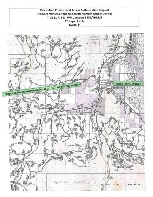
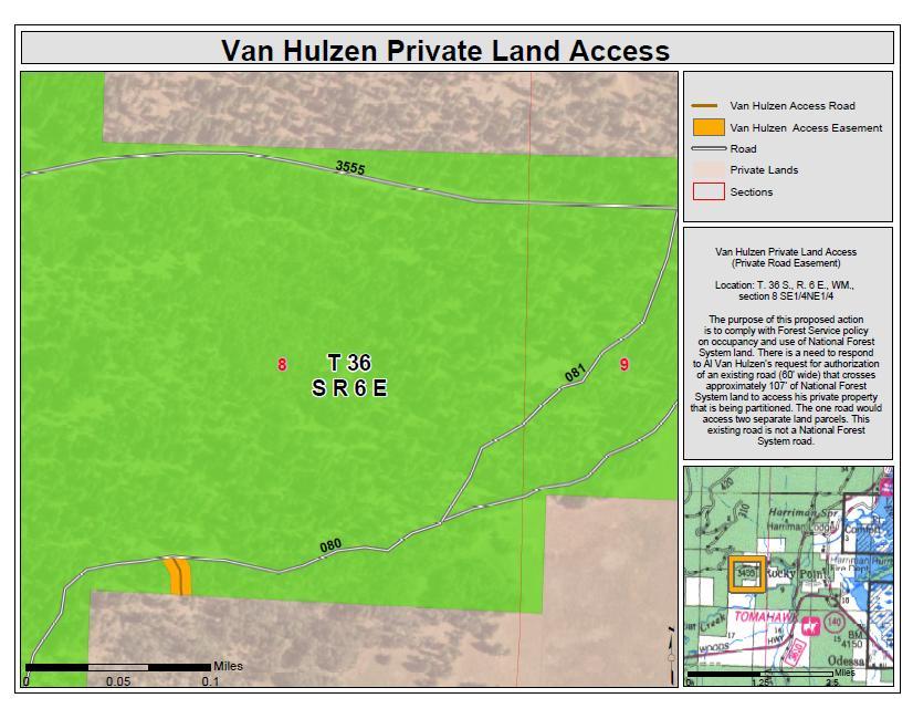
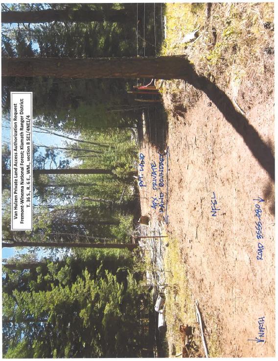
1 Project Proposals 1) Van Hulzen Private Land Access [Klamath RD] Proposed Category: 36 CFR 220.6(e) (3) Approval, modification, or continuation of minor special uses of NFS lands that require less than five contiguous acres of land. Legal Coordinates: T. 36 S., R. 6 E., WM., section 8 SE1/4 NE1/4 Background: The purpose of this purposed action is to comply with Forest Service policy on occupancy and use of National Forest System land. There is a need to respond to Al Van Hulzen s request for authorization of an existing road (60 wide) that crosses approximately 107 of National Forest System land to access his private property that is being partitioned. The road would access two separate land parcels. This existing road is not a National Forest System road. Project Design / Equipment: Private landowner would continue to use the Non-National Forest System road for motorized access to reach private land. Private landowner would use the road for motorized vehicle use and perform maintenance activities that would occur (i.e. snow plowing and grading). The road has existed for several years with no signs of resource concerns. Project Implementation: Existing road would be authorized under Private Road Easement with a review date of 30 years. Project Information: Catherine Callaghan, Realty Specialist, , ccallaghan@fs.fed.us 1
2 2
3 3
4 4
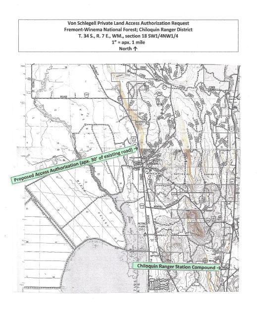
5 2) Von Schlegell Private Land Access Private Road Easement (Klamath RD) Proposed Category: 36 CFR 220.6(e) (3) Approval, modification, or continuation of minor special uses of NFS lands that requires less than five contiguous acers of land. Legal Coordinates: T. 34 S., R. 7 E., WM., section 18 SW1/4 NW1/4 Background: The purpose of this proposed action is to comply with the Forest Service policy on occupancy and use of National Forest System land. There is a need to respond to John Von Schlegell s request for authorization of an existing road that crosses approximately 30 of National Forest System land to access his private property that is being partitioned. This existing road is not a National Forest System road. Project Design / Equipment: Private landowner would continue to use the Non-National Forest System road for motorized access to reach private land. Routine motorized vehicle use and maintenance activities would occur (i.e. snowplowing; grading; culvert cleaning). This road has existed for several years with no signs of resource damage. Project Implementation: Existing road would be authorized under Private Road Easement with a review date of 30 years. Project Information: Catherine Callaghan, Realty Specialist, , ccallaghan@fs.fed.us 5
6 6

7 7
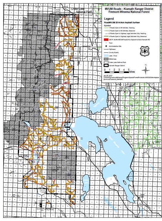
8 3)Klamath Personal Use Road-side Firewood [Klamath (RD)] Proposed Category: 36 CFR 220.6(d) (8): Approval, modification, or continuation of minor, short-term (1 year or less) special uses of NFS lands. Legal Coordinates: All unpaved MVUM open roads on the Klamath Ranger District. See map. Background:Currently the road system of the Klamath Ranger District is inundated with dead and down trees. This proposal will help with road maintenance and clearing accumulation of road-side downed wood Project Design / Equipment: Removal will be confined to 300 feet off all unpaved MVUM open roads. No cross country travel would be permitted per MVUM. Use of existing tracks within 300 feet of designated routes could be used. The only standing trees that will be removed are dead lodgepole pine and dead white fir, and all tree species can be removed that are dead and down. No heavy equipment can be used for removal. The only ground disturbance will be from pick-up trucks and trailers. Some road systems may see increased use where high accumulation of dead trees are present. Impacts to other resources should be minimal. This work will be accomplished using the personal use firewood program. The local community of Klamath Falls and surrounding areas will remove the dead material, following the Fremont- Winema personal use firewood rules and regulations and MVUM. Project Implementation: Time frame for this project would be on a temporary basis of 1 year, with a limited operating period of 10/1-12/30. Limited operating period proposed for Spotted Owl. Project Information: Cassidy Russell, Special Forest Products Program Manager, , carussell@fs.fed.us 8
9 9
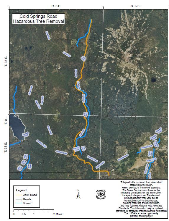
10 4)Cold Springs (3651 Rd) Danger Trees [Klamath (RD)] Proposed Category: 36 CFR 220.6(d) (4): Repair and maintenance of administrative sites. Legal Coordinates: T. 35 S., R. 5 E., W.M. sections 12, 13, 23, 24, 25, 26 Background: Current conditions along the 3651 Rd (Cold Spring) are as follows: The road runs through an area which in the last 6 years has experienced a significant amount of mortality in lodgepole pine do to bark beetle infestation. The 3651 Rd is a heavily traveled road used by the public to access the Cold Springs Trailhead. Recent winter and various wind storms have caused a dozens of dead trees to fall across the road, mainly between the Lost Creek and the Cold Springs Trailhead. This has caused a serious safety issue while traveling this section of road, both to the public and forest employees. Additionally the 3651 Rd is a one way in one way out road to the Cold Springs Trailhead, there have been and will continue to be issues with the public being trapped behind trees that have fallen while they were at the trail head. As a secondary benefit, inevitably the 3651 Rd will be used as a control feature for a wildfire in the wilderness at some point in the future. Removing standing dead trees that would fall across the road or increase fire intensity adjacent to the road now will reduce the work and hazard exposure during fire suppression activities. The desired condition is to limit the number of dead trees that are likely to fall across the road during the winter months and during wind storms and therefor reducing exposure to the public. Project Design / Equipment: The project will consist of felling all standing dead lodgepole trees within 100 feet of the roadway by the use of chainsaws. The limbs and slash from the felled trees would be piled for later burning. Tree felling will exacerbate existing high fuel loading adjacent to the road. Fuel loading would be reduced by designating the area for commercial and or personal use firewood gathering. Cutting, Piling, and Burning will be performed by Klamath Ranger district fire personnel and managed by the Assistant Fire Management Officer. Areas where work has been finished will be designated as a firewood collecting area for public use. Due to the fact trees will be felled by hand with chainsaws and no heavy equipment will be used little to no ground disturbance is expected to occur with this project, with the exception of some soil disturbance as a result of pile burning. No impacts are foreseen to other resource areas. Access to the area will remain open during this project, with the exception of stopping traffic intermittently while trees are being felled. 10
11 Project Implementation: This project is expected to start in the spring of 2017 when access to the area becomes available and should not take longer than 4 years to complete. Project completion time frames are mostly affected by inaccessible due to snow during the winter months and can include shoulder seasons of fall and spring. Work would only be able to occur during the time which the area is accessible (spring, summer, fall) and could be further restricted by chainsaw use restrictions due to high fire danger in summer months. In addition, since local fire crews will be preforming the work, their availability during fire season could limit the amount of time spent each year on the project. Project Information: Josh Fitzpatrick, Supervisory Fire Engine Operator, , jdfitzpatrick@fs.fed.us 11
12 12
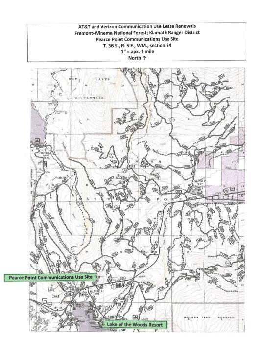
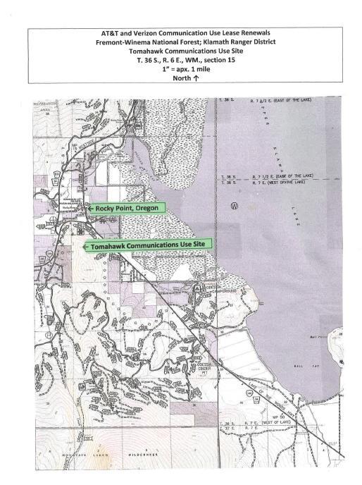
13 5)AT&T and Verizon communication Use Leases Renewals at Pearce Point; Soloman Butte; and Tomahawk [Klamath and Chiloquin Ranger District (RD)] Proposed Category: 36 CFR 220.6(e) (3): Approval, modification, or continuation of minor special uses of NFS lands that require less than five contiguous acres of land. Legal Coordinates: Pearce Point is in T.36 S., R. 5 E., WM., section 34; Tomahawk is in T. 36 S., R. 6 E., WM., section 15; Soloman Butte is in T. 33 S., R. 8 E., WM., section 7 Background: The purpose of this proposed action is to comply with the Forest Service policy on occupancy and use of the National Forest System land. There is a need to respond to AT&T and Verizon s requests for new communication use leases for their existing cellular facilities on National Forest System lands because their leases have either expired or will expire in the next year. Project Design / Equipment: Applicants would continue to use and maintain current communication use site facilities (equipment shelters; towers; backup generators; etc.). No impacts anticipated, as existing facilities have been in place for several years. Coordination under the draft communication use site management plan may outline shared road maintenance between communication use site lease holders and Crater Lake Zip Line permit holder (Tomahawk). Routine road maintenance activities include motorized vehicle use to maintain and upgrade facilities (additional antennas). Equipment used for the project include grader; backhoe; snowplow; crane (if additional antennas are installed). Project Implementation: Renewal of leases recommended for 20 years. Project Information: Mike DeSmit, Realty Specialist, , mdesmit@fs.fed.us for Pearce Point and Tomahawk and Catherine Callaghan, Realty Specialist, , ccallaghan@fs.fed.us for Soloman Butte 13

14 14
15 15
16 16
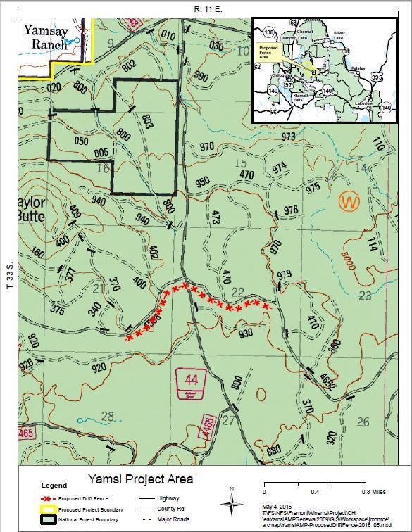
17 6)Yamsi Allotment South Pasture Drift Fence (Chiloquin RD) Proposed Category: 36 CFR 220.6(e) (9) Implementation or modification of minor management practices to improve allotment condition or animal distribution when an allotment management plan is not yet in place. Legal Coordinates: T 33S, R11E, W.M. section 22, SW of the NW Background: The purpose of this proposed action is to control the movement of livestock through pasture division fencing. Currently there is no physical barrier preventing livestock from leaving the south pasture prematurely. A drift fence strategically placed should reduce or eliminate this movement, allowing better control over the movement between the North and South Yamsi allotment pastures.current livestock management in the south pasture is difficult at best especially in years the south pasture is used last in the rotation. Cattle do not want to stay in the south and constantly drift north back to the home ranch prematurely. The main north-south road (forest road 44) provides an easy trail back to the Ranch from the primary rangelands around Teddy Powers and Wild Horse meadows. Project Design / Equipment:A Drift Fence of proximately 1 mile in length from the cattle guard on forest road 44 at the Juncture with forest road 4598 (west) and forest road 4652 (east) will allow better control of livestock. The south pasture drift fence will extend at least ½ mile west (south of road 4598) and ½ mile east (south of road 4652) from the 44 road. The fence shall parallel the roads for easy maintenance consisting of a 3 wire barbed wire fence with steel post and wood H-brace and or rock-crib bracing as needed (approximately 6 total), H braces will require digging post holes approximately 36 deep (probably by a tractor mounted auger). Project Implementation: Fence construction from cattle guard in 44 road will be by permittee using Forest Service provided specifications and Forest Service oversite. There is limited expected impacts to other forest resources and construction should start as soon as possible and be completed by the end of summer/fall Project Information: Joseph E. Robson, SW Zoned Rangeland Specialist, (541) , jrobson@fs.fed.us 17
18 18
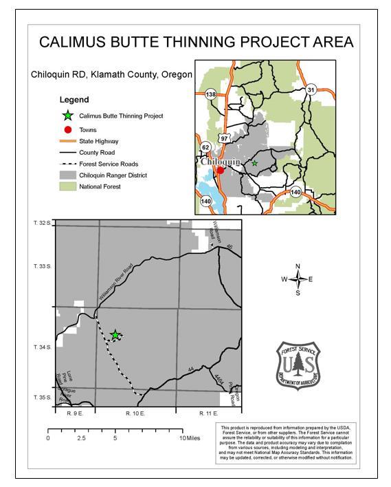
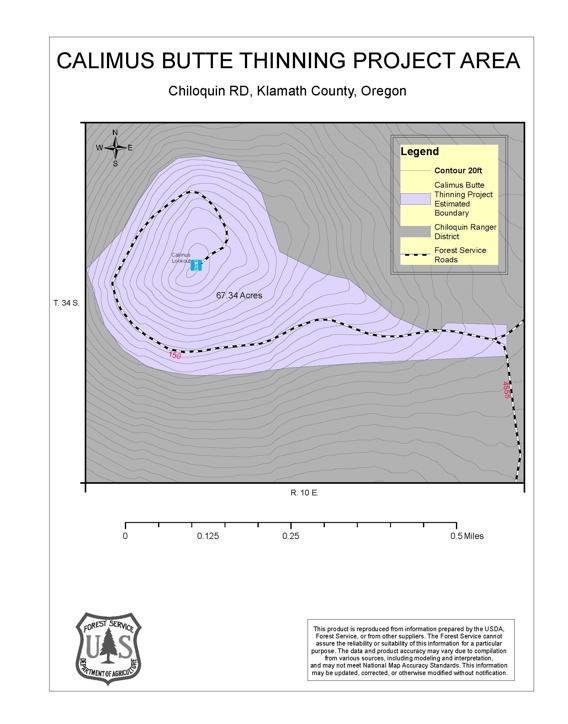
19 7)Calimus Butte Thinning (Chiloquin RD) Proposed Category: 36 CFR 220.6(e) (12) Harvest of live trees not to exceed 70 acres, requiring no more than ½ mile of temporary road construction. Legal Coordinates: T 34 S., R. 10 E., WM., sections 8 and 17 Background: Currently the stand of trees nearest the Calimus Butte lookout facilities have reached a height where they are beginning to impede visibility. Calimus lookout is the sole fire detection method on the Chiloquin Ranger District and an integral part of our fire management program. The effectiveness of this resource is being limited, and will continue to deteriorate as these trees grow and further restrict visibility. Project Design / Equipment:It is the purpose of this proposed action to restore visibility from the lookout by removing trees that are impeding visibility and thinning up to 67 acres surrounding the lookout. Tree thinning and removal may involve mechanical equipment or hand felling chainsaw operations. Activity fuels would be treated using one or both of the following methods: mechanical or hand piling for future burning and/or dispersing brush and boles on site to avoid excessive fuel loads. District personnel would fell the necessary trees. All ignitions on site would be conducted by agency personnel under allowable weather and fuels conditions. Project Implementation: The work would take place during the time of year when conditions allow for such operations and would not interfere or conflict with other resource area priorities. The length of time for such an operation would be approximately 2-4 weeks. Public motorized access would not be permitted on the road during operations. The estimated timeframe or restricted access is projected to be 1-3 weeks. Project Information: Evan Wright, Assistant Fire Management officer, , elwright@fs.fed.us 19
20 20
21 21
DECISION MEMO. Verizon Spring Creek Hill Cell Tower
 DECISION MEMO Verizon Spring Creek Hill Cell Tower Fremont-Winema National Forests Chiloquin Ranger District Klamath County, OR PROPOSED ACTION: Verizon, through Cascadia P.M., L.L.C., has submitted an
Ridgeline Energy SUP Anemometer Towers & SODAR Project Project Proposal & Public Scoping
 Ridgeline Energy SUP Anemometer Towers & SODAR Project Project Proposal & Public Scoping The Silver Lake and Paisley District Ranger of the Fremont-Winema National Forests is proposing to issue a special
Keefer Pasture Drift Fence Project. Challis-Yankee Fork Ranger District Salmon-Challis National Forest
 Keefer Pasture Drift Fence Project Challis-Yankee Fork Ranger District Salmon-Challis National Forest PROPOSED ACTION The Challis-Yankee Fork Ranger District proposes construction of approximately.11 miles
Bald Fire Salvage and Restoration Project
 Bald Fire Salvage and Restoration Project Range Report Prepared by: KC Pasero Rangeland Management Specialist Hat Creek Ranger District /s/ KC Pasero April 27, 2015 Introduction The Bald Fire Salvage and
CATEGORICAL EXCLUSION WORKSHEET: RESOURCE CONSIDERATIONS
 CATEGORICAL EXCLUSION WORKSHEET: RESOURCE CONSIDERATIONS Developed Recreation/Trails, Wilderness & Roadless Jasper Mountain Priest Lake Ranger District Idaho Panhandle National Forest Description of the
Umpqua National Forest
 United States Department of Agriculture Forest Service Umpqua National Forest Tiller Ranger District 27812 Tiller Trail Highway Tiller, Oregon 97484 (541) 825-3100 Fax 825-3110 Dear Interested Citizen,
The Galton Project Kootenai National Forest. The Galton Project
 Introduction The Galton Project The Fortine Ranger District of the Kootenai National Forest is in the early stages of developing a project entitled Galton, named for the mountain range dominating the eastern
Childs Meadow Fence Project Almanor Ranger District, Lassen National Forest
 Childs Meadow Fence Project Almanor Ranger District, Lassen National Forest Tehama County, California April 6, 2015 Introduction The Almanor Ranger District (ALRD) of the Lassen National Forest (LNF) proposes
Paradise and Watson Creek Headcut Treatment Project (see map on next page)
") Paradise and Watson Creek Headcut Treatment Project (see map on next page) T 34 S, R 15 E, Sections 11, 13 and 14 The purpose of the project would be to stabilize the stream channel by treating headcuts
Paradise and Watson Creek Headcut Treatment Project (see map on next page) T 34 S, R 15 E, Sections 11, 13 and 14 The purpose of the project would be to stabilize the stream channel by treating headcuts
Dear Interested Party:
 United States Department of Agriculture Forest Service Beaverhead-Deerlodge National Forest 420 Barrett Street Dillon, MT 59725 406 683-3900 File Code: 1950 Date: June 7, 2011 Dear Interested Party: Thank
Appendix B Adaptive Management Strategy
 Adaptive Management Strategy This appendix identifies the adaptive management strategy that would be implemented as part of the proposed action. This strategy and the processes contained and described
MOTI -- Five Strand Barbed Wire & Paige Wire Fence Specifications
 MOTI -- Five Strand Barbed Wire & Paige Wire Fence Specifications SCHEDULE 8 (and attached drawings) FIVE STRAND BARBED-WIRE FENCE SPECIFICATIONS Rocky Mountain District General If equipment is used at
Notes for Smith Shields Public Meeting & Field Trip
 Notes for Smith Shields Public Meeting & Field Trip July 27 & 29, 2016; Livingston, MT and Project Area These notes are intended to capture the broader topics, issues and concerns discussed at the public
IGNITION PLAN Brooker Creek Preserve Unit: Red Trail
 IGNITION PLAN Brooker Creek Preserve Unit: Red Trail Red Trail unit will be burned using backing and strip fires. This unit can be burned during four wind direction and each direction requires a different
A windbreak across a large field distributes snow throughout the field, providing winter protection and moisture for crop production.
 In areas of high winds and blowing snow, windbreaks can reduce the amount of effort spent on snow management. They can be designed to spread snow across a large area or to confine it to a relatively small
Protection of Rangeland and Pastures from Wildfire
 Protection of Rangeland and Pastures from Wildfire Grazing lands are subject to wildfire because of an abundance of fine fuel (grass), frequent dry conditions, and proximity to an ignition source -usually
Preliminary Decision Memo 2017 BPA Utility Corridor Maintenance and Danger Tree Project
 Preliminary Decision Memo 2017 BPA Utility Corridor Maintenance and Danger Tree Project USDA Forest Service Crescent Ranger District, Deschutes National Forest Klamath County, Oregon The Crescent Ranger
FSM 2000 NATIONAL FOREST RESOURCE MANAGEMENT ZERO CODE 2080 NOXIOUS WEED MANAGEMENT
 FOREST SERVICE MANUAL NORTHERN REGION (REGION 1) MISSOULA, MT. ZERO CODE NOXIOUS WEED MANAGEMENT Supplement No.: R1 2000-2001-1 Effective Date: May 14, 2001 Duration: Effective until superseded or removed
Decision Memo for Pax Ponderosa Pine Planting Project
 Decision Memo for Pax Ponderosa Pine Planting Project USDA Forest Service Pacific Northwest Region Fremont-Winema National Forests Lakeview Ranger District Lake County, Oregon Introduction The Lakeview
Recreation Resources Technical Report
 United States Department of Agriculture Recreation Resources Technical Report Forest Service Intermountain Region Boise National Forest May 2017 In Support of the Environmental Assessment South Pioneer
Poker Chip Project. Noxious Weed Risk Assessment Almanor Ranger District Lassen National Forest
 Noxious Weed Risk Assessment Almanor Ranger District Lassen National Forest June 3, 2013 Introduction When a ground-disturbing action or activity is proposed, a Noxious Weed Risk Assessment (NWRA) determines
PROJECT INFORMATION AMEREN POWERLINE RECONSTRUCTION PROJECT April 2014
 PROJECT INFORMATION AMEREN POWERLINE RECONSTRUCTION PROJECT April 2014 The United States Forest Service (USFS), Shawnee National Forest (SNF), is analyzing a request from Ameren Services (Ameren), a group
FINAL TIMBER REMOVAL and MANAGEMENT PLAN BLUE LAKE HYDROELECTRIC PROJECT (FERC NO. 2230) EXPANSION. Prepared By: Dean Orbison
 EXPANSION. Prepared By: Dean Orbison") FINAL TIMBER REMOVAL and MANAGEMENT PLAN BLUE LAKE HYDROELECTRIC PROJECT (FERC NO. 2230) EXPANSION Prepared By: Dean Orbison For the City and Borough of Sitka Electric Department December, 2010 INTRODUCTION
FINAL TIMBER REMOVAL and MANAGEMENT PLAN BLUE LAKE HYDROELECTRIC PROJECT (FERC NO. 2230) EXPANSION Prepared By: Dean Orbison For the City and Borough of Sitka Electric Department December, 2010 INTRODUCTION
Oregon National Forests:
 Oregon National Forests: Deschutes & Ochoco National Forests http://www.fs.fed.us/r6/centraloregon/ Crooked River National Grassland 1001 SW Emkay Drive Bend, OR 97702 (541) 383-5300 Over the past few
2015 Insect and Disease Update for Rocky Mountain. Region
 2015 Insect and Disease Update for Rocky Mountain Bob Cain USDA Forest Service State and Private Forestry and Tribal Relations Forest Health Protection Region Mountain Pine Beetle Spruce beetle Douglas-fir
BOISE FOREST COALITION MEETING BOGUS BASIN UPDATE
 BOISE FOREST COALITION MEETING BOGUS BASIN UPDATE WELCOME AND INTRODUCTIONS Idaho Department of Fish and Game 600 S. Walnut, Boise, Idaho Trophy Room October 15, 2015 Facilitators, Dick Gardner and Jim
PRESCRIBED FIRE IN SOUTHWEST IDAHO
 2016 PRESCRIBED FIRE IN SOUTHWEST IDAHO In southwest Idaho, public land managers work to: address public health and safety concerns; treat insect and disease infestations; reduce the risk of severe wildfires
Jack and Rock Meadows
 Jack Creek and Rock Creek Meadows Fuel Reduction and Meadow Restoration Project ---------- Chemult Ranger District Fremont-Winema National Forests Klamath County, Oregon Background Moist and wet meadows
MAINTENANCE WORKER 1 JOB DESCRIPTION
 MAINTENANCE WORKER 1 JOB DESCRIPTION GENERAL DESCRIPTION Under supervision, an employee of this classification performs semi-skilled, skilled, and manual labor including operation of dump trucks, semi-tractor
PROJECT IDENTIFICATION SHEET PROPOSED PROJECTS ON EMIGRANT CREEK RANGER DISTRICT
 PROJECT IDENTIFICATION SHEET PROPOSED PROJECTS ON EMIGRANT CREEK RANGER DISTRICT PROJECT TITLE: 41 Road Hazard Tree Removal PROJECT LEAD: Karlene Burman PROJECT NEPA COORDINATOR: Lori Bailey PROJECT DESCRIPTION:
Big Hill Insect and Disease Project Proposed Action
 Big Hill Insect and Disease Project Proposed Action Project Background and 2014 Farm Bill The Big Hill Insect and Disease project on the Challis-Yankee Fork Ranger District of the Salmon-Challis National
Dear Interested Party,
 United States Department of Agriculture Forest Service Medicine Bow Routt National Forests and Thunder Basin National Grassland Parks Ranger District 100 Main Street, PO Box 158 Walden, CO 80480-0158 970-723-2700
Decision Memo for Juniper Ridge Opal Mine
 for USDA Forest Service Pacific Northwest Region Fremont-Winema National Forests Bly Ranger District Klamath County, Oregon Introduction The Bly Ranger District has received a proposed operating plan for
Introduction. Methodology for Analysis
 1 Medicine Lake Caldera Vegetation Treatment Project Scenic Report Prepared by: /s/gary Kedish Natural Resources Specialist for: Big Valley and Doublehead Ranger Districts Modoc National Forest February
Recreation Report Kimball Hill Stands Management Gold Beach Ranger District, Rogue River-Siskiyou National Forest Date: April 27, 2016
 Kimball Hill Stands Management Gold Beach Ranger District, Rogue River-Siskiyou National Forest /s/ Date: April 27, 2016 Lorelei Haukness, Resource Specialist Rogue River-Siskiyou National Forest In accordance
DECISION MEMO MANHATTAN FUELS REDUCTION PROJECT U.S. FOREST SERVICE CANYON LAKES RANGER DISTRICT LARIMER COUNTY, CO
 DECISION MEMO MANHATTAN FUELS REDUCTION PROJECT U.S. FOREST SERVICE CANYON LAKES RANGER DISTRICT LARIMER COUNTY, CO Background and Project Description In order to improve forest health and reduce hazardous
Dear Interested Party,
 United States Department of Agriculture Forest Service Gunnison Ranger District 216 N Colorado St. Gunnison, CO 81230 Voice: 970-641-0471 TDD: 970-641-6817 File Code: 1950-1/2430 Date: June 8, 2010 Dear
Kurtis Robins District Ranger US Forest Service 138 S Main
 United States Department of Agriculture Forest Service Fishlake National Forest Fax: (435) 836-2366 138 S Main, PO Box 129 Loa, UT 84747 Phone: (435) 836-2811 File Code: 1950 Date: April 5, 2011 Kurtis
DECISION MEMO. Vipond Water Development
 Page 1 of 5 DECISION MEMO USDA Forest Service Wise River Ranger District Beaverhead County T2S, R10W, Sections 12, 13, 14, &18 Background This project is located in the Pioneer Landscape, East Face Management
The following recommendations will need to be re-evaluated given the recent fire at the Kennedy Meadows Pack Station.
 Kennedy Meadows Planning Unit The following recommendations will need to be re-evaluated given the recent fire at the Kennedy Meadows Pack Station. Sustainable Forestry Evaluate existing timber inventory
Sheppard Creek Post-Fire Project
 Flathead National Forest Tally Lake Ranger District Sheppard Creek Post-Fire Project Purpose of the Project and Proposed Action December 14, 2007 This document presents information about the Brush Creek
Notice is hereby given that bids will be received by the Unit Manager, ROSCOMMON MANAGEMENT UNIT, for certain timber on the following described lands:
 DEPARTMENT OF NATURAL RESOURCES STATE OF MICHIGAN TIMBER SALE PROSPECTUS #6236 SCHEDULED SALE DATE AND TIME: 2:00 p.m. (local time) on November 20, 2018. LOCATION: ROSCOMMON MGMT UNIT, PO BOX 218, ROSCOMMON,
Proposed Action for Motorized Travel Management on the North Kaibab Ranger District
 United States Department of Agriculture Forest Service Proposed Action for Motorized Travel Management on the North Kaibab Ranger District Kaibab National Forest March 2010 The U.S. Department of Agriculture
MAINTENANCE WORKER 2 JOB DESCRIPTION
 MAINTENANCE WORKER 2 JOB DESCRIPTION GENERAL DESCRIPTION Under direction, an employee of this classification performs semi-skilled, skilled, and manual labor including operation of dump trucks, semi-tractor
BLM Office: Lakeview District, Klamath Falls Resource Area Phone #:
 Decision Memorandum on Action and for Application of: Categorical Exclusion 516 DM2, Appendix 1, 1.12 Hazardous Fuel Reduction (PLAN CONFORMANCE AND CATEGORICAL EXCLUSION DETERMINATION) CX Log #: CX-04-16
Forest Restoration and Fire Prevention in the Lake Tahoe Basin
 Forest Restoration and Fire Prevention in the Lake Tahoe Basin Legislative Committee for the Review and Oversight of the Tahoe Regional Planning Agency (TRPA) and the Marlette Lake Water System January
MAINTENANCE WORKER 2 JOB DESCRIPTION
 MAINTENANCE WORKER 2 JOB DESCRIPTION GENERAL DESCRIPTION Under direction, an employee of this classification performs semi-skilled, skilled, and manual labor including operation of dump trucks, semi-tractor
DEPARTMENT OF NATURAL RESOURCES STATE OF MICHIGAN TIMBER SALE PROSPECTUS #5727
 DEPARTMENT OF NATURAL RESOURCES STATE OF MICHIGAN TIMBER SALE PROSPECTUS #5727 SCHEDULED SALE DATE AND TIME: 2:00 p.m. (local time) on October 12, 2016. LOCATION: SHINGLETON MGMT UNIT, PO BOX 67 M-28 WEST,
Reading Project Noxious Weed Risk Assessment Hat Creek Ranger District Lassen National Forest April 3, 2013
 Reading Project Noxious Weed Risk Assessment Hat Creek Ranger District Lassen National Forest April 3, 2013 Prepared By: /s/ Tim Kellison Date: 05-31-2013 Tim Kellison Assistant Forest Botanist Reviewed
Questions & Answers 1. Question: Where can I get a copy of the Alternative Maps? Answer:
 Questions & Answers 1. Question: Where can I get a copy of the Alternative Maps? Answer: Draft EA Documents, including maps are online www.fs.usda.gov/project/?project=46467 2. Question: How were public
DECISION RECORD for the Rattlesnake Negotiated Timber Sale (Reference:
 DECISION RECORD for the Rattlesnake Negotiated Timber Sale (Reference: Bly Mtn. / Swan Lake / Rattlesnake Reservoir Forest Health and Woodland Treatments Environmental Assessment #OR014-99-6) Introduction
ROAD MAINTENANCE AND IMPROVEMENT PLAN
 ROAD MAINTENANCE AND IMPROVEMENT PLAN October 3, 2018 TABLE OF CONTENTS Page 2 INTRODUCTION Page 3 GUIDING PRINCIPLES Page 3 ASSET MANAGEMENT Page 3 ROAD CLASSIFICATION Page 4 ROAD MAINTENANCE Page 4 GRAVEL
DECISION MEMO. Pine Ridge Fire Vegetation Project. USDA Forest Service Fremont-Winema National Forest Chiloquin Ranger District Klamath County, Oregon
 DECISION MEMO Pine Ridge Fire Vegetation Project USDA Forest Service Fremont-Winema National Forest Chiloquin Ranger District Klamath County, Oregon Legal Location: Township 34 South, Range 7 East, Sections
Boulder Ranger District
 United States Department of Agriculture Forest Service Boulder Ranger District 2140 Yarmouth Avenue Boulder, CO 80301-1615 Voice: (303) 541-2500 Web: www.fs.usda.gov/arp Fax: (303) 541-2515 File Code:
COUNTY OF EL DORADO PLANNING AND BUILDING DEPARTMENT ZONING ADMINISTRATOR STAFF REPORT MINOR USE PERMIT
 COUNTY OF EL DORADO PLANNING AND BUILDING DEPARTMENT ZONING ADMINISTRATOR STAFF REPORT Agenda of: November 21, 2018 Item No: Staff: 5.a. Melanie Shasha MINOR USE PERMIT FILE NUMBER: APPLICANT: AGENT: OWNER:
Elk Post-fire Restoration Reforestation Project USDA Forest Service Boise National Forest Mountain Home Ranger District Elmore County, Idaho
 Introduction and Location Project USDA Forest Service Boise National Forest Mountain Home Ranger District Elmore County, Idaho The Mountain Home Ranger District experienced several large wildfires during
Lake Fire Restoration and Hazardous Tree Removal. Project Proposed Action and Scoping Document
 United States Department of Agriculture Forest Service November 2016 Lake Fire Restoration and Hazardous Tree Removal Heather McRae Project Proposed Action and Scoping Document USDA Forest Service Shasta-Trinity
Vestal Project Proposed Action Hell Canyon Ranger District Black Hills National Forest April 2011
 Vestal Project Proposed Action Hell Canyon Ranger District Black Hills National Forest April 2011 Introduction: The Vestal Project area is located surrounding the city of Custer, South Dakota within Custer
BURNEY GARDENS PLANNING UNIT Cow-Battle Creek Watershed
 Existing Conditions & Uses Overview Formerly homesteaded scenic mountain meadows and forestland surrounded by private timber and grazing lands 1,611 acres in Shasta County No FERC Project associated with
File Code: 1950 Date: September 13, 2017
 United States Department of Agriculture Forest Service Darby-Sula Ranger District 712 N. Main Street Darby, MT 59829 406-821-3913 File Code: 1950 Date: September 13, 2017 The Bitterroot National Forest
TAHOE DONNER FORESTRY DEFENSIBLE SPACE UPDATE BOARD OF DIRECTORS MEETING JUNE 22, 2018
 TAHOE DONNER FORESTRY DEFENSIBLE SPACE UPDATE BOARD OF DIRECTORS MEETING JUNE 22, 2018 Highlight the Association s commitment to provide resources towards reducing the fire hazard in the area and forest
Notice is hereby given that bids will be received by the Unit Manager, NEWBERRY MANAGEMENT UNIT, for certain timber on the following described lands:
 DEPARTMENT OF NATURAL RESOURCES STATE OF MICHIGAN TIMBER SALE PROSPECTUS #6377 SCHEDULED SALE DATE AND TIME: 3:00 p.m. (local time) on February 14, 2019. LOCATION: NEWBERRY MGMT UNIT, 5666 S STATE HWY
COUNTY, OREGON T20 S R14E SECTIONS 25 AND 36; T20S R15E SECTIONS 19-34; AND T21S R15E SECTIONS 3-9 AND
 PINE MOUNTAIN SAGE GROUSE HABITAT RESTORATION PROJECT Bend/ Fort Rock Ranger District Deschutes National Forest DESCHUTES COUNTY, OREGON T20 S R14E SECTIONS 25 AND 36; T20S R15E SECTIONS 19-34; AND T21S
Acres within Planning Area. Total Acres Burned
 Calf-Copeland Project Description Figure 1: Dead sugar pine in the Calf-Copeland planning area. Sugar pine grow best in open conditions. In the absence of fire disturbance, high densities of Douglas-fir
Recreation Resources Technical Report
 United States Department of Agriculture Forest Service Intermountain Region Boise National Forest June 2017 Recreation Resources Technical Report In Support of the Final Environmental Assessment South
Siuslaw National Forest. Central Coast Ranger District - Oregon Dunes National Recreation Area
 United States Department of Agriculture Forest Service Siuslaw National Forest Central Coast Ranger District - Oregon Dunes National Recreation Area 1130 Forestry Lane Waldport, OR 97394 File Code: 1950
9.2 Definitions. The following terms are defined, for purposes of Section 9, as follows:
 SECTION 9. COMMERCIAL WIND ENERGY FACILITIES 9.1 Purpose. The purpose of this Section 9 of the Zoning Bylaw is to provide by special permit for the construction and operation of commercial wind facilities
Draft Pine Mountain Late- Successional Reserve Habitat Protection and Enhancement Project
 Draft Pine Mountain Late- Successional Reserve Habitat Protection and Enhancement Project RecreationReport Prepared by: for: Upper Lake Ranger District Mendocino National Forest Month, Date, YEAR The U.S.
Pole Creek Timber Salvage Project Specialist Report. Transportation. Introduction. Regulatory Framework / Management Direction
 Pole Creek Timber Salvage Project Specialist Report Transportation Donald Walker P.E. June 13, 2013 Introduction This report describes the effects to the transportation system from the Pole Creek Timber
Upper Fryingpan Vegetation Management Project
 DRAFT Decision Notice Upper Fryingpan Vegetation Management Project USDA Forest Service Aspen/Sopris Ranger District, White River National Forest Pitkin and Eagle Counties, Colorado Portions of sections
3.25 TRANSPORTATION SYSTEM
 3.25 TRANSPORTATION SYSTEM 3.25.1 Introduction This transportation system section is a part of Chapter 3 because the Interdisciplinary team identified a need to present the transportation system information
Notice is hereby given that bids will be received by the Unit Manager, ROSCOMMON MANAGEMENT UNIT, for certain timber on the following described lands:
 DEPARTMENT OF NATURAL RESOURCES STATE OF MICHIGAN TIMBER SALE PROSPECTUS #6236 SCHEDULED SALE DATE AND TIME: 2:00 p.m. (local time) on November 20, 2018. LOCATION: ROSCOMMON MGMT UNIT, PO BOX 218, ROSCOMMON,
Eldorado National Forest; California; Eldorado National Forest Over-Snow Vehicle. Notice of intent to prepare an environmental impact statement.
 [3410-11- P] DEPARTMENT OF AGRICULTURE Forest Service Eldorado National Forest; California; Eldorado National Forest Over-Snow Vehicle (OSV) Use Designation Environmental Impact Statement AGENCY: ACTION:
1.2 How is Grazing Managed on the Wallowa-Whitman National Forest
 1. Introduction We are proposing to update the allotment management plans for four grazing allotments on the Whitman Ranger District of the Wallowa-Whitman National Forest. We are proposing to prepare
Proposed Action and Alternatives
 Chapter Proposed Action and Alternatives Page 15 CHAPTER 2 - PROPOSED ACTION AND ALTERNATIVES INTRODUCTION Chapter 2 describes and compares the Southwest Fence Relocation and Waterline Project s Proposed
Statement for the Record. Forest Service. United States Department of Agriculture. For the United States House of Representatives
 Statement for the Record Forest Service United States Department of Agriculture For the United States House of Representatives Committee on Natural Resources Subcommittee on Public Lands and Environmental
Storrie and Rich Fire Area Watershed Improvement and Forest Road 26N67 Re-alignment Project
 Notice of Proposed Action Opportunity to Provide Scoping Comments Storrie and Rich Fire Area Watershed Improvement and Forest Road 26N67 Re-alignment Project Mt. Hough Ranger District Plumas National Forest
Commercial Firewood Project. McCall and New Meadows Ranger Districts Payette National Forest
 1 Commercial Firewood Project McCall and New Meadows Ranger Districts Payette National Forest PROPOSED ACTION The proposal would harvest approximately 47 acres of trees in the Upper Elkhorn Creek drainage,
Mixed Conifer Working Group Meeting April 15, 2011 Water and Soil Resource Management Considerations
 Mixed Conifer Working Group Meeting April 15, 2011 Water and Soil Resource Management Considerations It is difficult to tie watershed health directly to mixed-conifer forests. Watersheds encompass a variety
David/Tom, here are some maps and a little write up on timber projects for your cumulative effects analysis. Let me know if more questions.
 David Johnson From: Sent: To: Subject: Attachments: Self, Kirby -FS Friday, March 16, 2012 8:55 AM david@westerneco.com; Malecek, Thomas -FS WCV Land Exchange Cumulative Effects of Timber
File Code: 1950 Date: November 17, 2015
 Logo Department Name Agency Organization Organization Address Information United States Forest Deschutes National Forest 63095 Deschutes Market Road Department of Service Bend/Fort Rock Ranger District
Preliminary Decision Memo 2015 Recreation Residence Projects Odell Lake
 2015 Recreation Residence Projects Odell Lake USDA Forest Service Crescent Ranger District, Deschutes National Forest Klamath County, Oregon Background The Crescent Ranger District maintains 66 recreation
Tri-State Montrose-Nucla-Cahone Transmission Line Improvement Project. Plan of Development
 Tri-State Montrose-Nucla-ahone Transmission Line Improvement Project Montrose, Ouray, San Miguel, and Dolores ounties, olorado Traffic and Transportation Management Plan R-1 Traffic and Transportation
DECISION NOTICE AND FINDING OF NO SIGNIFICANT IMPACT. Bend-Fort Rock Ranger District Deschutes National Forest Lake County, Oregon
 DECISION NOTICE AND FINDING OF NO SIGNIFICANT IMPACT Bend-Fort Rock Ranger District Deschutes National Forest Lake County, Oregon Devil's Garden Planning Area Hole-in-the-Ground Subunit Environmental Assessment
Climate Change. Introduction
 Climate Change This environmental assessment incorporates by reference (as per 40 CFR 1502.21) the Climate Change specialists report and other technical documentation used to support the analysis and conclusions
RIM FIRE Preliminary Fuel Treatment Effectiveness Report
 RIM FIRE Preliminary Fuel Treatment Effectiveness Report USDA Forest Service, Pacific Southwest Region, Stanislaus National Forest DOI National Park Service, Pacific West Region, Yosemite National Park
Appendix A (Project Specifications) Patton Mill Fuel Break Project
 Patton Mill Fuel Break Project") Appendix A (Project Specifications) Patton Mill Fuel Break Project I. Proposed Actions: A. Construct a Fuel Break (approximately 5 miles, about 120 acres): The fuel break is located along a segment of
Appendix A (Project Specifications) Patton Mill Fuel Break Project I. Proposed Actions: A. Construct a Fuel Break (approximately 5 miles, about 120 acres): The fuel break is located along a segment of
File Code: 1950 Date: September 26, Dear Interested Party:
 Fremont-Winema National Forest Grazing Allotments Project Silver Lake Ranger District P.O. Box 129 Silver Lake, OR 97638 541-576-2107 541-576-2450 FAX Chemult Ranger District P.O. Box 150 Chemult, OR 97731
DOUGLAS COUNTY ZONING RESOLUTION Section 17 Wildfire Hazard - Overlay District 3/10/99. -Section Contents-
 SECTION 17 WILDFIRE HAZARD - OVERLAY DISTRICT -Section Contents- 1701 Intent... 17-2 1702 Definitions... 17-2 1703 Applicability... 17-5 1704 Wildfire Hazard Overlay District Map... 17-6 1705 Wildfire
Wildlife Conservation Society Climate Adaptation Fund 2014 Restoring Oak Resilience at the Table Rocks, Rogue River Basin, Oregon FACT SHEET
 Wildlife Conservation Society Climate Adaptation Fund 2014 Restoring Oak Resilience at the Table Rocks, Rogue River Basin, Oregon FACT SHEET Project Overview Oak ecosystems in the Pacific Northwest exist
Grandfather Restoration Project
 Grandfather Restoration Project a Collaborative Forest Landscape Restoration (CFLR) Program Presentation by Lisa Jennings Grandfather Restoration Project Coordinator lisanjennings@fs.fed.us August 12,
BLM Office: Lakeview District, Klamath Falls Resource Area Phone #:
 Decision Memorandum on Action and for Application of: Categorical Exclusion 516 DM2, Appendix 1, 1.12 Hazardous Fuel Reduction (PLAN CONFORMANCE AND CATEGORICAL EXCLUSION DETERMINATION) CX Log #: CX-04-15
(OSV) Use Designation Environmental Impact Statement. Notice of intent to prepare an environmental impact statement.
 Use Designation Environmental Impact Statement. Notice of intent to prepare an environmental impact statement.") This document is scheduled to be published in the Federal Register on 03/04/2015 and available online at http://federalregister.gov/a/2015-04459, and on FDsys.gov [3410-11- P] DEPARTMENT
This document is scheduled to be published in the Federal Register on 03/04/2015 and available online at http://federalregister.gov/a/2015-04459, and on FDsys.gov [3410-11- P] DEPARTMENT
Resource Report. for Range. Ochoco East OHV Trail Environmental Impact Statement
 United States Department of Agriculture Forest Service June1, 2010 Resource Report for Range Ochoco East OHV Trail Environmental Impact Statement Lookout Mountain Ranger District Ochoco National Forest
3.14 VISUAL RESOURCE (SCENERY)
") 3.14 VISUAL RESOURCE (SCENERY) 3.14.1 INTRODUCTION The Lower West Fork analysis area lies in the Bitterroot Mountain Range and is bisected by the West Fork Road (State Highway 473). The Lower West Fork
3.14 VISUAL RESOURCE (SCENERY) 3.14.1 INTRODUCTION The Lower West Fork analysis area lies in the Bitterroot Mountain Range and is bisected by the West Fork Road (State Highway 473). The Lower West Fork
DEPARTMENT OF NATURAL RESOURCES STATE OF MICHIGAN TIMBER SALE PROSPECTUS #6282
 DEPARTMENT OF NATURAL RESOURCES STATE OF MICHIGAN TIMBER SALE PROSPECTUS #6282 SCHEDULED SALE DATE AND TIME: 8:30 a.m. (local time) on November 28, 2018. LOCATION: CRYSTAL FALLS MGT UNIT, 1420 US-2 WEST,
2012 Flood Repair Projects
 2012 Flood Repair Projects Okanogan-Wenatchee National Forest Naches Ranger District 10237 U.S. Highway 12 Naches, WA 98937 (509) 653-1401 Cle Elum Ranger District 803 W. 2nd Street Cle Elum, WA 98922
BLM Office: Lakeview District, Klamath Falls Resource Area Phone #:
 Decision Memorandum on Action and for Application of: Categorical Exclusion 516 DM2, Appendix 1, 1.12 Hazardous Fuel Reduction (PLAN CONFORMANCE AND CATEGORICAL EXCLUSION DETERMINATION) CX Log #: CX-04-17
Proposed Action and Alternatives
 Chapter Proposed Action and Alternatives Chapter 2 Proposed Action and Alternatives Page 15 CHAPTER 2 - PROPOSED ACTION AND ALTERNATIVES INTRODUCTION Chapter 2 describes and compares the Southwest Fence
CATEGORICAL EXCLUSION WORKSHEET: RESOURCE CONSIDERATIONS
 CATEGORICAL EXCLUSION WORKSHEET: RESOURCE CONSIDERATIONS Operations Lower Snake WUI Dillon Ranger District White River National Forest Description of the Proposed Action Vegetation management activities