A Salt Marsh Advancement Zone Assessment of West Haven, Connecticut
|
|
|
- Francis Hensley
- 6 years ago
- Views:
Transcription

1 A Salt Marsh Advancement Zone Assessment of West Haven, Connecticut
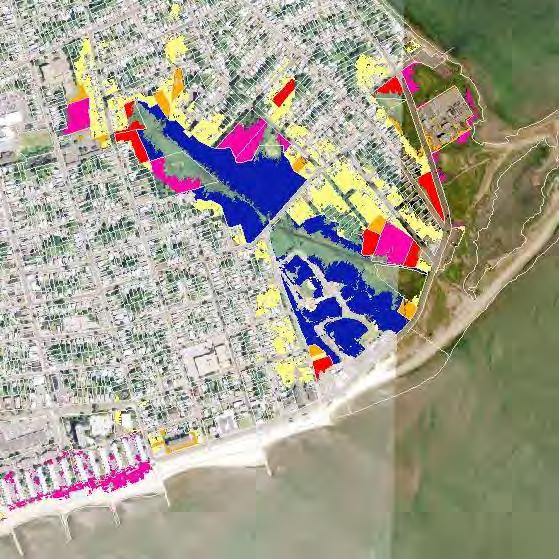
2 Front cover image: Open space and unprotected parcels critical to the conservation of marsh advancement corridors in West Haven; from the accompanying Comprehensive Map Book of West Haven, Connecticut.
3 Table of Contents Introduction... 2 Suitable vs. Unsuitable Advancement... 3 Marsh Advancement vs. Wetland Extent... 3 Planning for the Future... 3 Total Marsh Advancement... 4 Marsh Advancement in Open Space Parcels... 4 Total Advancement in Open Space Parcels... 4 Suitable Open Space Advancement by Owner... 5 Suitable Advancement by Open Space Parcel... 6 Marsh Advancement in All Parcels... 6 Total Advancement in All Parcels (OS vs. Non-OS)... 7 Suitable Advancement by All Parcels... 8 Appendix Map Book... 9 RECOMMENDED CITATION: Ryan, A. and A. W. Whelchel A Salt Marsh Advancement Zone Assessment of West Haven, Connecticut. The Nature Conservancy, Coastal Resilience Program. Publication Series #1-R, New Haven, Connecticut. ACKNOWLEDGEMENTS: This effort was made possible through partial funding by the Horizon Foundation, Vervane Foundation, and the McCance Foundation Trust. Page 1
4 Introduction In 2006, The Nature Conservancy established the Coastal Resilience Program ( that provides tools and a solution framework to reduce the ecological and socio-economic risk of hazards and comprehensively improve community resilience. The Program focuses on helping decision-makers explore locally relevant, downscaled, flooding scenarios from sealevel rise and/or storm surge, analyze the potential ecological, social and economic impacts of each scenario at a local, regional, and state scale, and facilitate solutions to address these issues. Since 2006, The Nature Conservancy has assisted many coastal and inland communities in Connecticut by providing this critical information and a comprehensive, community-based process that improves overall resilience and sustainability. There is a universal recognition by coastal and inland communities in Connecticut and elsewhere that natural infrastructure wetlands and forests - is a cost effective, long-term part of the solution to help protect people, infrastructure and natural systems from extreme weather and climatic change. Fortunately, our state has a remarkable diversity and abundance of natural resources that provide habitat for wildlife and fisheries, enhance the aesthetics and quality of life for residents, and, of course, defend the shoreline and rivers against storm surge, inland flooding, and sea level rise. The presence of natural resources across the state in particular salt marsh, beaches/dunes, forested headwaters, and river floodplains is the result of previous recognition and commitment to long-term conservation and the requisite balance with socio-economic growth. In order to maintain these natural resources it will require 1) routine and on-going management activities as well as the restoration of degraded areas, 2) forward-looking planning to accommodate changes in habitat composition and location due to climatic change and 3) enforcement, modification and/or development of new land use policies and growth strategies. Opportunities also exist to account for and integrate the services or co-benefits provided by natural infrastructure via new development, redevelopment, or realignment activities. Economically important services/co-benefits from natural infrastructure include wave attenuation, improved water storage and filtering of pollutants from surface runoff, erosion control, and improved aesthetics and desirable public amenities. Taken in total, the immediate and longer-term management of natural infrastructure by the state, towns, private property owners, non-profit organizations, and others will help to reduce hazard risk and improve resilience across Connecticut. While longer-term changes in temperature and precipitation patterns will alter the species composition and type of habitats in a given location, the more immediate implication is the upslope advancement of habitats such as salt marsh in response to continued sea level rise. Sea level rise and the impacts of flooding have and will continue to alter the presence and abundance of natural resources in Connecticut. One of the most noticeable changes is occurring at the shoreline s edge where salt marsh is in the process of advancing upslope into areas now considered uplands. In order to clearly identify where this will occur along West Haven s shoreline, The Nature Conservancy presents the following report to assist with future planning for natural resources in the context of overall risk reduction and resiliency improvement for the community. Ultimately, it is our hope that this report will serve to inform the community about Page 2
5 future marsh advancement locations, current land use of those locations and which parcels are critical to ensure the persistence of natural resources in West Haven longer term. The Salt Marsh Advancement Model used in this analysis was co-developed by The Nature Conservancy and the University of Connecticut s Department of Natural Resources Management and Engineering. A full discussion of the Model and underlying methodology is beyond the scope of this report, but a few important details are needed to put the following analysis into context and define how to use the results for planning and implementation. Suitable vs. Unsuitable Advancement In the following figures and tables suitable advancement areas are abbreviated as Yes and unsuitable areas are abbreviated as No. Suitable areas are classified based on the current land cover type - forest or agrigrass - and as such are expected to convert to salt marsh as hydrologic conditions change due to sea level rise, in the absence of further land use conversion. Land cover types classified as urban (i.e. roads, buildings, runways, parking lots, etc ) are considered to be unsuitable for salt marsh advancement at this time. Though much of our analysis is grouped by parcel ID and associated characteristics, these classifications suitable and unsuitable exist independent of the parcel boundaries. In other words, a given residential parcel can have both suitable (lawn) and unsuitable (building footprint) advancement areas. Marsh Advancement vs. Wetland Extent There is a key distinction in this report between the current wetland extent in a municipality and the marsh advancement areas analyzed herein. Marsh advancement areas include only the future projected wetland extent clipped to current upland land cover. Therefore, no assumption should be made about net gain or loss of current wetland extent based on this advancement area analysis. Another key consideration is that in some cases the identified advancement area will include land that converts to wetlands and subsequently to open-water over time. This further demonstrates that net change in both existing and future wetland extent should not be inferred from our analysis. Planning for the Future The advancement and eventual establishment of coastal marshes will occur over the course of several decades and as such our analysis extends out to the 2080s. The rate of change is slow and decadal, yet inevitable. There is an abundance of existing property, infrastructure and natural infrastructure assets clustered along the Connecticut coast and communities will need to formulate growth and realignment plans well in advance of the 2080s scenario presented here. The following data analysis and associated map book (Appendix) can assist with a resilient transition through the presentation of marsh advancement areas and an accounting of the projected changes to coastal property. Page 3
6 Total Marsh Advancement The full extent of marsh advancement in West Haven by the 2080s is projected to be acres, with acres (74.1%) having suitable (Yes) land cover for wetland advancement. The other acres (25.9%) are occupied by built structures and associated infrastructure and are unsuitable for marsh advancement (No), currently. Total Marsh Advancement by 2080s Percent Marsh Adv Acres (%) Yes No Total Marsh Advancement in Open Space Parcels Open space (OS) properties are a critical component of long-term community resilience because they currently have little to no development and are the most likely areas to remain undeveloped through the 2080s. The recognition of the role of these parcels in future wetland extent and improved resilience in West Haven is vital for strategic land management, economic development, and planning. Total Advancement in Open Space Parcels The following three categories are considered in this section: Yes OS: Areas of open space suitable for marsh advancement No OS: Areas of open space unsuitable for marsh advancement Non-OS: Unprotected areas both suitable and unsuitable for marsh advancement West Haven s open space parcels contain acres of total marsh advancement area with acres (37.1% of total) having a land cover suitable for future wetlands (Yes OS). Further analysis of the acres of unprotected parcels (Non-OS) can be found in the following Marsh Advancement in All Parcels section. Open Space Marsh Advancement Open Space Marsh Advancement 54.8% 37.1% Yes OS No OS Non-OS OS type Acres Yes OS No OS 40.2 Non-OS Total % Page 4
7 Suitable Open Space Advancement by Owner The city of West Haven owns the greatest share of suitable open space for marsh advancement accounting for acres (93.6%). Private owners hold the remaining share of suitable open space with 11.8 acres (6.4%). Suitable Open Space Advancement Owner type Acres Total "yes" OS (%) Total "yes" adv (%) Municipal Private Total Suitable Open Space Advancement 6.4% Municipal Private 93.6% Page 5
8 Suitable Advancement by Open Space Parcel West Haven has 65 open space parcels that intersect the full extent of marsh advancement by the 2080s. There are 10 open space parcels that each provides more than 4 acres of advancement area with a total aggregate of acres (79.0%) of West Haven s suitable open space marsh advancement area. The top two parcels contributing the most suitable marsh advancement zone are both located along Old Field Creek and together contribute 27.7% of the total (185.1 acres). 30 Open Space parcels with > 4 acres of Suitable Marsh Advancement (n = 10) Acres Parcel ID Open Space parcels with > 4 acres Suitable Marsh Advancement Total "yes" OS Parcel ID Acres (%) Owner Map Book Page # Municipal Municipal Municipal Municipal Municipal Municipal Municipal Municipal Municipal Municipal 7 Total Page 6
9 Marsh Advancement in All Parcels This section incorporates all parcels into the analysis of suitable marsh advancement. These results help put the open space analysis into perspective, as well as identify important unprotected parcels in West Haven s marsh advancement landscape. Total Advancement in All Parcels (OS vs. Non-OS) West Haven s existing open space parcels are made up of municipal parks and recreation properties, municipal open space, cemeteries, public schools, and certain private properties. This section provides an analysis of suitable areas for marsh advancement on these open space parcels versus all other parcels. These two types of parcels are designated as: OS for open space parcels Non-OS for all other parcels Open space parcels contain acres (50.1% of total) of suitable marsh advancement zone. The other acres of land suitable for marsh advancement (49.9% of total) are unprotected and generally occur on residential, commercial, or industrial properties. The unprotected suitable areas will receive a significant amount of marsh advancement by 2080s. This information has two important implications for future planning: 1) today s unprotected properties will play a vital role in maintaining West Haven s wetland resources in the future, and 2) a large amount of current development (89.2 acres) will be in direct conflict with rising sea levels and advancing marshes. 300 Total Marsh Advancement in All Parcels 250 Acres No Yes Total Marsh Advancement Parcel type Yes No Total OS Non-OS Total OS Non-OS Page 7
10 Suitable Advancement by All Parcels There are 866 parcels in West Haven that provide areas of suitable marsh advancement, but only 17 parcels offer suitable areas greater than 4 acres. This small subset provides acres of marsh advancement zone or 53.5% of West Haven s overall total. The specific parcels can be viewed via the corresponding Map Book pages (Appendix) indicated in the table below. Acres Parcels with > 4 acres of Suitable Marsh Advancement (n=17) Parcel ID Open Space parcels in dark green Parcel ID Parcels with > 4 acres of Suitable Marsh Advancement Acres Page 8 Total yes adv (%) Map Book Page # ,6,11, ,6,11, ,7,11, ,7,11, ,6,11, ,7,11, ,7,11, Total
11 Appendix Map Book Please consult your Salt Marsh Advancement Resource Disc for the complete dataset of suitable and unsuitable advancement per parcel. Page 9
12

13 Comprehensive Map Book of West Haven, Connecticut
14 This pag e intentionally left blank
15 -- Table of Contents -- Overview Maps Marsh Advancement Unprotected Parcels Critical Parcels Inset Maps Unprotected Parcels Advancement per Parcel Page 1
16 Marsh Advancement by the 2080s Marsh Advancement - North Mile ± Marsh Advancement by 2080s Developed Land Cover Forest, Grass, Ag Land Cover North South Page 2
17 Marsh Advancement by the 2080s Marsh Advancement - South Mile ± Marsh Advancement by 2080s Developed Land Cover Forest, Grass, Ag Land Cover North South Page 3
18 Marsh Advancement by the 2080s Unprotected Parcels - North Mile ± Parcels Marsh Advancement by 2080s Unprotected Non-OS Developed Land Cover Forest, Grass, Ag Land Cover Note: Only Non-OS parcels with > 4 acres of suitable advancement are shown. North South Page 4
19 Marsh Advancement by the 2080s Unprotected Parcels - South Mile ± Parcels Marsh Advancement by 2080s Unprotected Non-OS Developed Land Cover Forest, Grass, Ag Land Cover Note: Only Non-OS parcels with > 4 acres of suitable advancement are shown. North South Page 5
20 Marsh Advancement by the 2080s Critical Parcels - North Mile ± Note: Only Non-OS and OS parcels with > 4 acres of suitable advancement are shown. Parcels Unprotected Non-OS Protected OS North South Page 6
21 Marsh Advancement by the 2080s Critical Parcels - South Mile ± Note: Only Non-OS and OS parcels with > 4 acres of suitable advancement are shown. Parcels Unprotected Non-OS Protected OS North South Page 7
22 This pag e intentionally left blank Page 8
23 Marsh Advancement by the 2080s Map Index - Unprotected Parcels A2 B2 C2 C3 D1 D2 Page 9
24 Feet ,000 2,000 3,000 see page 11 Marsh Advancement by the 2080s Unprotected Parcels - Map A2 A2 Parcels Unprotected Non-OS Marsh Advancement Developed Land Cover Forest, Grass, Ag Land Cover µ Note: Only Non-OS parcels with > 4 acres of suitable marsh advancement are shown. D1 B2 C2 D2 C3 Page 10
25 see page Feet ,000 2,000 3,000 see page 12 Marsh Advancement by the 2080s Unprotected Parcels - Map B2 A2 Parcels Unprotected Non-OS Marsh Advancement Developed Land Cover Forest, Grass, Ag Land Cover µ Note: Only Non-OS parcels with > 4 acres of suitable marsh advancement are shown. D1 B2 C2 D2 C3 Page 11
26 see page 11 see page 13 Feet ,000 2,000 3,000 see page 15 Marsh Advancement by the 2080s Unprotected Parcels - Map C2 A2 Parcels Unprotected Non-OS Marsh Advancement Developed Land Cover Forest, Grass, Ag Land Cover µ Note: Only Non-OS parcels with > 4 acres of suitable marsh advancement are shown. D1 B2 C2 D2 C3 Page 12
27 see page 12 Feet ,000 2,000 3,000 Marsh Advancement by the 2080s Unprotected Parcels - Map C3 A2 Parcels Unprotected Non-OS Marsh Advancement Developed Land Cover Forest, Grass, Ag Land Cover µ Note: Only Non-OS parcels with > 4 acres of suitable marsh advancement are shown. D1 B2 C2 D2 C3 Page 13
28 see page 15 Feet ,000 2,000 3,000 Marsh Advancement by the 2080s Unprotected Parcels - Map D1 A2 Parcels Unprotected Non-OS Marsh Advancement Developed Land Cover Forest, Grass, Ag Land Cover µ Note: Only Non-OS parcels with > 4 acres of suitable marsh advancement are shown. D1 B2 C2 D2 C3 Page 14
29 see page 12 see page 14 Feet ,000 2,000 3,000 Marsh Advancement by the 2080s Unprotected Parcels - Map D2 A2 Parcels Unprotected Non-OS Marsh Advancement Developed Land Cover Forest, Grass, Ag Land Cover µ Note: Only Non-OS parcels with > 4 acres of suitable marsh advancement are shown. D1 B2 C2 D2 C3 Page 15
30 This pag e intentionally left blank Page 16
31 Marsh Advancement by the 2080s Map Index - Advancement per Parcel A2 B2 C2 C3 D1 D2 Page 17
32 Feet ,000 2,000 3,000 see page 19 Marsh Advancement by the 2080s Advancement per Parcel - Map A2 A2 Advancement per Parcel < 0.5 acres > 20 acres µ Note: Only Non-OS parcels with > 4 acres of suitable marsh advancement are shown. D1 B2 C2 D2 C3 Page 17
33 see page Feet ,000 2,000 3,000 see page 20 Marsh Advancement by the 2080s Advancement per Parcel - Map B2 A2 Advancement per Parcel < 0.5 acres > 20 acres µ Note: Only Non-OS parcels with > 4 acres of suitable marsh advancement are shown. D1 B2 C2 D2 C3 Page 18
34 see page 19 see page 21 Feet ,000 2,000 3,000 see page 23 Marsh Advancement by the 2080s Advancement per Parcel - Map C2 A2 Advancement per Parcel < 0.5 acres > 20 acres µ Note: Only Non-OS parcels with > 4 acres of suitable marsh advancement are shown. D1 B2 C2 D2 C3 Page 19
35 see page 20 Feet ,000 2,000 3,000 Marsh Advancement by the 2080s Advancement per Parcel - Map C3 A2 Advancement per Parcel < 0.5 acres > 20 acres µ Note: Only Non-OS parcels with > 4 acres of suitable marsh advancement are shown. D1 B2 C2 D2 C3 Page 20
36 see page 23 Feet ,000 2,000 3,000 Marsh Advancement by the 2080s Advancement per Parcel - Map D1 A2 Advancement per Parcel < 0.5 acres > 20 acres µ Note: Only Non-OS parcels with > 4 acres of suitable marsh advancement are shown. D1 B2 C2 D2 C3 Page 21
37 see page 20 see page 22 Feet ,000 2,000 3,000 Marsh Advancement by the 2080s Advancement per Parcel - Map D2 A2 Advancement per Parcel < 0.5 acres > 20 acres µ Note: Only Non-OS parcels with > 4 acres of suitable marsh advancement are shown. D1 B2 C2 D2 C3 Page 22

38
CITY OF PORTSMOUTH, NEW HAMPSHIRE
 TIDES TO STORMS PREPARING FOR NEW HAMPSHIRE S FUTURE COAST Assessing Risk and Vulnerability of Coastal Communities to Sea Level Rise and Storm Surge Seabrook - Hampton Falls Hampton - North Hampton Rye
POLICY FOR NATURAL RESOURCE MANAGEMENT AREAS
 POLICY FOR NATURAL RESOURCE MANAGEMENT AREAS I. POLICY STATEMENT Auburn University's (the University's) "Policy for Natural Resource Management Areas" implements the Campus Master Plan Land Use Element
Protecting Open Space & Ourselves
 Protecting Open Space & Ourselves Reducing Flood Risk in the Gulf of Mexico Through Strategic Land Conservation NATURE.ORG/GULF PROTECTING OPEN SPACE & OURSELVES: REDUCING FLOOD RISK IN THE GULF OF MEXICO
Acres 32% 35% Not Suitable. Impervious. Possible UTC. Vegetation. Existing UTC
 Acres A Report on Washington, D.C. s Urban Tree Canopy Why is Tree Canopy Important? Urban tree canopy (UTC) is the layer of leaves, branches, and stems of trees that cover the ground when viewed from
STREAM AND BUFFER AREA PROTECTION/RESTORATION
 STREAM AND BUFFER AREA PROTECTION/RESTORATION AMENDMENT OPTIONS TO STRENGTHEN POLICY IN HEADWATERS AREAS DRAFT SUBSEQUENT TO THE JANUARY 25, 2007 MEETING OF THE PLANNING COMMISSION ENVIRONMENT COMMITTEE
Natural Resources and Climate Resiliency in Germantown
 Natural Resources and Climate Resiliency in Germantown Ingrid Haeckel, Andrew Meyer, and Elizabeth Murphy NYSDEC Hudson River Estuary Program and Cornell University Presentation to the Town of Germantown,
CITY OF MOUNTAIN VIEW
 CITY OF MOUNTAIN VIEW Incorporate Climate Change Adaptation in Municipal Scale, Urban Watershed Planning at the City of Mountain View Raymond Wong, PhD, PE, LEED AP Lisa Au, PE Floodplain Management Association
A Partnership for Saving West Africa s Coastal Assets
 A Partnership for Saving West Africa s Coastal Assets 2015 West Africa Coastal Areas Management Program (WACA) 1 Africa s development and climate agendas are inextricably linked: If unaddressed, climate
WATERSHED. Maitland Valley. Report Card 201
 Maitland Valley WATERSHED Report Card 201 The Maitland Valley Conservation Authority has prepared this report card as a summary on the state of our forests, wetlands, surface water, and ground water resources.
Building Resilient Communities - Low Impact Development and Green Infrastructure Strategies
 Building Resilient Communities - Low Impact Development and Green Infrastructure Strategies October 24, 2013 Bridgewater State University E. Heidi Ricci Senior Policy Analyst Mass Audubon Shaping the Future
New Jersey Forest Stewardship Program Spatial Analysis Project Map Products And Data Layers Descriptions
 New Jersey Forest Stewardship Program Spatial Analysis Project 2007 Map Products And Data Layers Descriptions 01/07 NJ Forest Stewardship Program (FSP) Spatial Analysis Project (SAP) Methodology Project
Integrating Water Quality and Natural Filters into Maryland s Marine Spatial Planning Efforts
 Integrating Water Quality and Natural Filters into Maryland s Marine Spatial Planning Efforts Nicole Carlozo NOAA Coastal Management Fellow July 31, 2014 Watershed-scale restoration targeting helps direct
STREAM RESTORATION PURPOSE, PRACTICE, AND METHODS. By Marcus Rubenstein, CPESC
 STREAM RESTORATION PURPOSE, PRACTICE, AND METHODS By Marcus Rubenstein, CPESC WHAT IS STREAM RESTORATION? The return of a stream s lost natural functions, usually resulting from watershed alterations,
Estuary Adventures. Background. Objective
 Estuary Adventures Objective Students will work in groups to understand the concept of estuaries, their importance, and the role that density plays in the mixing of fresh and salt water. Students will
Quantifying the Benefits of Stream Restoration
 Quantifying the Benefits of Stream Restoration 10 th Annual GAFM Technical Conference, March 2016 Jarrod Karl, Hazen and Sawyer Presentation Outline Benefits of Stream Restoration The Watershed Approach
Go Green, Save Money: Lowering Flood Insurance Rates in Virginia with Stormwater Management. Kristen Clark VCPC Alumna, Spring 2014
 Go Green, Save Money: Lowering Flood Insurance Rates in Virginia with Stormwater Management Kristen Clark VCPC Alumna, Spring 2014 Rising Waters, Rising Rates Coastal Communities in Virginia are confronted
Project Goals and Scoping
 Prepared for: Boulder County, Colorado Flood Planning & Preliminary Design Services for South St. Vrain Creek Restoration at Hall Ranch and Scoping May 24, 2016 Meeting with General Public In association
(1) Bridge, Road and Railway (Adaptation Project) (2) Bridge, Road and Railway (BAU Development with Adaptation Options)
 Bridge, Road and Railway (Adaptation Project) (2) Bridge, Road and Railway (BAU Development with Adaptation Options)") Sub-sector Guideline: (1) Bridge, Road and Railway (Adaptation Project) (2) Bridge, Road and Railway (BAU Development with Adaptation Options) Basic Concept A. General Concept Climate change will increase
Sub-sector Guideline: (1) Bridge, Road and Railway (Adaptation Project) (2) Bridge, Road and Railway (BAU Development with Adaptation Options) Basic Concept A. General Concept Climate change will increase
Environment & Conservation Introduction
 Environment & Conservation Introduction Anacortes is blessed with an abundance of natural beauty. Residents identify marine shorelines, streams, lakes, forested areas, and other natural features as defining
Provincial Policy Statement 2014 Training Aid
 This job aid has been developed for education and training purposes as a high-level summary of the policy changes in the PPS 2014. It should not be relied upon as a substitute for specialized legal or
VILLAGE OF BELLAIRE WATER QUALITY ACTION PLAN
 VILLAGE OF BELLAIRE WATER QUALITY ACTION PLAN Elk-River-Chain-of-Lakes Gaps Analysis Project The Watershed Center Grand Traverse Bay Tip of the Mitt Watershed Council Michigan Department of Natural Resources
Performance Standard 6 V2
 Introduction 1. Performance Standard 6 recognizes that protecting and conserving biodiversity, maintaining ecosystem services, and sustainably managing living natural resources are fundamental to sustainable
A Freshwater Blueprint for Maritime Canada
 A Freshwater Blueprint for Maritime Canada Union of Nova Scotia Municipalities (UNSM) November 8 th, 2017 William Millar Aquatic Conservation Biologist william.millar@natureconservancy.ca Craig Smith Conservation
719 Griswold, Suite 820 Detroit, MI DANVERS POND DAM REMOVAL AND STREAM RESTORATION PROJECT
 Great Lakes Restoration Initiative Grant Final Report US EPA Grant GL 00E006 43 October, 2013 Valley Woods Wetland Southfield Lola Valley Grow Zone Wayne County Parks Venoy Park Grow Zone Wayne County
PUBLIC NOTICE. REPLY TO: Denver Regulatory Office 9307 South Wadsworth Blvd 30 DAY NOTICE Littleton, CO FAX (303)
") PUBLIC NOTICE US Army Corps of Engineers Omaha District Application No: NWO-2017-01366-DEN Project: Douglas Lane Tributary Stabilization Project Applicant: Town of Castle Rock Waterway: Douglas Lane Tributary
PUBLIC NOTICE US Army Corps of Engineers Omaha District Application No: NWO-2017-01366-DEN Project: Douglas Lane Tributary Stabilization Project Applicant: Town of Castle Rock Waterway: Douglas Lane Tributary
A Report on Existing and Possible Tree Canopy in the City of Charlotte and Mecklenburg County, NC
 A Report on Existing and Possible Tree Canopy in the City of Charlotte and Mecklenburg County, NC Why is Tree Canopy Important? Tree canopy (TC) is the layer of leaves, branches, and stems of trees that
Land Management and Flooding. Where are we now?
 Land Management and Flooding Where are we now? Tarland farmer s workshop Andrea Johnstonova, SEPA The talk will cover Some background information: NFM under the FRM Act Implementation so far and examples
TIER 1 DRAFT ENVIRONMENTAL IMPACT STATEMENT. 7. Affected Environment, Environmental Consequences, and Mitigation Strategies
 TIER 1 DRAFT ENVIRONMENTAL IMPACT STATEMENT 7. Affected Environment, Environmental Consequences, and Mitigation Strategies Table of Contents Chapter 7 7 Affected Environment, Environmental Consequences,
JOINT PUBLIC NOTICE SAM PAH U. S. ARMY CORPS OF ENGINEERS MISSISSIPPI DEPARTMENT OF ENVIRONMENTAL QUALITY OFFICE OF POLLUTION CONTROL
 DEPARTMENT OF THE ARMY U.S. ARMY ENGINEER DISTRICT, MOBILE DISTRICT P.O. BOX 2288 MOBILE, ALABAMA 36628-0001 June 2, 2015 CESAM-RD-C PUBLIC NOTICE NO. SAM-2015-00573-PAH JOINT PUBLIC NOTICE SAM-2015-00573-PAH
Standards for SWMF s. (Stormwater Management Facilities) Lacombe County s Guide to Developing Stormwater Management Facilities
 Lacombe County s Guide to Developing Stormwater Management Facilities") Standards for SWMF s (Stormwater Management Facilities) Lacombe County s Guide to Developing Stormwater Management Facilities August 2017 PREAMBLE Development results in a great amount of impervious area,
Standards for SWMF s (Stormwater Management Facilities) Lacombe County s Guide to Developing Stormwater Management Facilities August 2017 PREAMBLE Development results in a great amount of impervious area,
The Next Generation of Mitigation: Linking Current and Future Mitigation Programs with State Wildlife Action Plans and Other State and Regional Plans
 : Linking Current and Future Mitigation Programs with State Wildlife Action Plans and Other State and Regional Plans August 4, 2009 Jessica B. Wilkinson, James M. McElfish, Jr., and Rebecca Kihslinger
Long Island: Water Resources. Water Sayings. Water Issues. Water Quality Issues specific to LI Coastal Areas. Agriculture and Water Regulation
 Water Sayings Long Island: Water Resources Copyright 2011 AFG 1 All living things need water to survive after air. Water, water everywhere but not a drop to drink. The quality of water is just as important
Natural Flood Management. Measures & Multiple Benefits. Steve Rose (JBA)
") Natural Flood Management Measures & Multiple Benefits Steve Rose (JBA) Definitions Natural Flood Management - NFM (SEPA): A range of techniques that aim to reduce flooding by working with natural features
Natural Flood Management Measures & Multiple Benefits Steve Rose (JBA) Definitions Natural Flood Management - NFM (SEPA): A range of techniques that aim to reduce flooding by working with natural features
Living Shorelines & Coastal Resiliency: A Consultants Perspective. Presented by: Bethany Bearmore, P.E. Louis Berger
 Living Shorelines & Coastal Resiliency: A Consultants Perspective Presented by: Bethany Bearmore, P.E. Louis Berger Living Shorelines & Coastal Resiliency A Consultants Perspective 1. Why 2. Process 3.
CHAPTER 7. San Dieguito River Flooding Adaptation
 CHAPTER 7 San Dieguito River Flooding Adaptation This chapter includes a range of adaptation measures to address vulnerabilities from flooding along the San Dieguito River, including the river valley,
Municipal Stormwater Management Planning
 Municipal Stormwater Management Planning Christopher C. Obropta, Ph.D., P.E. Water Resources Extension Specialist with Rutgers Cooperative Extension Assistant Professor with Department of Environmental
Applying Ecosystem Services to Collaborative Forest Management Elk River Public Meeting
 Applying Ecosystem Services to Collaborative Forest Management Elk River Public Meeting Nikola Smith Ecologist and Ecosystem Services Specialist U.S. Forest Service Port Orford City Hall February 2, 2017
7 Mineral and Energy Resources
 7 Mineral and Energy Resources This chapter examines Humboldt County s mineral (including sand and gravel extraction) and energy (oil, gas, and geothermal) resources. Existing General Plan policies and
LAND USE POLICIES BY COMMUNITY DESIGNATION
 137 2040 138 Land Use Policies by Community Designation As discussed earlier in Thrive MSP 2040, the Council assigns a community designation to each city and township. This designation indicates the overall
Pierce County s Green Y
 Rural Meets Urban Pierce County s Green Y The Central Puget Sound Region continues to lose agricultural lands and other open space, especially at the urban fringe. Figure 1 provides a stark image of the
GREAT BAY REGION, NEW HAMPSHIRE
 CLIMATE RISK IN THE SEACOAST Assessing Vulnerability of Municipal Assets and Resources to Climate Change Rollinsford Dover Madbury Durham Newmarket Newfields Exeter Stratham Greenland Newington GREAT BAY
U.S. Army Corps of Engineers Mobile District
 U.S. Army Corps of Engineers Mobile District General Permit for Living Shorelines in Alabama Sandy P. Gibson Regulatory Specialist, Coastal Alabama Regulatory Division, Mobile District US Army Corps of
Report to N.C. Legislative Commission on Global Climate Change March 15, 2010
 Summary of March 2010 Planning for North Carolina s Future: Ask the Climate Question Climate Change Adaptation Workshop hosted by N.C. Interagency Leadership Team And Next Steps Report to N.C. Legislative
Wildlife Conservation Strategy
 Wildlife Conservation Strategy Boise National Forest What is the Wildlife Conservation Strategy? The Boise National Forest is developing a Wildlife Conservation Strategy (WCS) in accordance with its Land
Habitat Grant Projects Clinton River Watershed
 Habitat Grant Projects Clinton River Watershed L Y N N E S E Y M O U R E N V I R O N M E N T A L E N G I N E E R O F F I C E O F T H E M A C O M B C O U N T Y P U B L I C W O R K S C O M M I S S I O N
Community Disaster Resilience
 Community Disaster Resilience Overview Disaster Management Cycle Community Disaster Resilience Hands on Approach for Increasing Community Disaster Resilience Addressing Weaknesses Planning for the Future
15A NCAC 07H.0209 COASTAL SHORELINES (a) Description. The Coastal Shorelines category includes estuarine shorelines and public trust shorelines.
 Description. The Coastal Shorelines category includes estuarine shorelines and public trust shorelines.") 15A NCAC 07H.0209 COASTAL SHORELINES (a) Description. The Coastal Shorelines category includes estuarine shorelines and public trust shorelines. Estuarine shorelines AEC are those non-ocean shorelines
15A NCAC 07H.0209 COASTAL SHORELINES (a) Description. The Coastal Shorelines category includes estuarine shorelines and public trust shorelines. Estuarine shorelines AEC are those non-ocean shorelines
Chapter 10 Natural Environment
 Chapter 10 Natural Environment Existing Conditions The Natural Environment Element addresses the protection, conservation, preservation, and restoration of the natural resources the Bayview Ridge Subarea,
Jamestown S Klallam Tribe
 Adaptation Plan Addendum: Two additional Key Areas of Concern Jamestown S Klallam Tribe September 2013 Acknowledgements Thank You This project would not have been successful with out the combined efforts
Day 1 Workshop Activities 1 & 2: Habitats and Species/Species Groups
 Day 1 Workshop Activities 1 & 2: Habitats and Species/Species Groups Instructions for Small Group Discussions Divide up into umbrella habitats groups A & B Upland Desert/Grassland Wetland Riparian/Riverine
Adaptation to Extreme Weather Events and Climate Change
 Office of Planning, Environment and Realty Office of Infrastructure Adaptation to Extreme Weather Events and Climate Change SASHTO Meeting Robert Kafalenos, FHWA August 25, 2014 1 Planning for the Future
Chapter 6. Hydrology. 6.0 Introduction. 6.1 Design Rainfall
 6.0 Introduction This chapter summarizes methodology for determining rainfall and runoff information for the design of stormwater management facilities in the City. The methodology is based on the procedures
Science Plan. Executive Summary. Introduction
 Science Plan Executive Summary This Science Plan will establish and define the focus of the Peninsular Florida Landscape Conservation Cooperative (PFLCC) science investments. The data and products derived
Hydrologic and Ecologic Impacts from the CERP Indian River Lagoon South Project
 Hydrologic and Ecologic Impacts from the CERP Indian River Lagoon South Project Dr. Gretchen Ehlinger Senior Biologist US Army Corps of Engineers Jacksonville District November 15, 2016 AWRA Conference
Tools Quantifying the Benefits and Life Cycle Costs of Green Infrastructure Sakshi Saini
 Tools Quantifying the Benefits and Life Cycle Costs of Green Infrastructure Sakshi Saini Latornell Conference November 17, 2016 Outline Background Tools: 1. Low Impact Development Treatment Train Tool
CLIMATE CHANGE ADAPTATION PLAN OF BEN TRE PROVINCE
 30. C l i m a t e C h a n g e A d a p t a t i o n P l a n o f B e n T r e P r o v i n c e PRESENTATION CLIMATE CHANGE ADAPTATION PLAN OF BEN TRE PROVINCE November 09 Mr. Truong Duy Hai Ben Tre DONRE TOPOGRAPHY
Linking Land Use to Water Quality
 Title Slide Title Slide Linking Land Use to Water Quality NEMO Intro/Credit Slide This educational slide show has been created by the NEMO Project at the University of Connecticut Cooperative Extension
Sea-level Rise Science and Decision Making in an Uncertain Future. Rob Thieler U.S. Geological Survey Woods Hole, MA
 Sea-level Rise Science and Decision Making in an Uncertain Future Rob Thieler U.S. Geological Survey Woods Hole, MA Concepts Sea-level rise is one of the most certain impacts of climate change. There is
EFFECT OF UPSTREAM DEVELOPMENT ON THE CLEAR CREEK AREA
 EFFECT OF UPSTREAM DEVELOPMENT ON THE CLEAR CREEK AREA Technical Memorandum Farming in the Floodplain Project Prepared for May 2017 PCC Farmland Trust Photo credit: Google Earth TABLE OF CONTENTS Page
ENVIRONMENT LONG-TERM GOAL: INTRODUCTION: Environment 117
 ENVIRONMENT LONG-TERM GOAL: There is a complex relationship between physical geography and human life. Humans continually have a significant impact upon the environment through actions such as construction,
TORCH LAKE TOWNSHIP WATER QUALITY ACTION PLAN
 TORCH LAKE TOWNSHIP WATER QUALITY ACTION PLAN Elk-River-Chain-of-Lakes Gaps Analysis Project The Watershed Center Grand Traverse Bay Tip of the Mitt Watershed Council Michigan Department of Natural Resources
Coastal Texas Protection and Restoration Project
 Coastal Texas Protection and Restoration Project Sharon Tirpak / Sheridan Willey / Janelle Stokes Project Management / Planning / Environmental USACE, Galveston District August 2014 US Army Corps of Engineers
Runoff Volume: The Importance of Land Cover
 Runoff Volume: The Importance of Land Cover Grade Level: 9-12 Time: 1-2 class periods Learning Objectives: - Quantify the volume of water that runs off different land uses in a watershed. - Analyze the
SOUTHWEST CONNECTICUT RELIABILITY PROJECT
 SOUTHWEST CONNECTICUT RELIABILITY PROJECT BY THE CONNECTICUT LIGHT AND POWER COMPANY DOING BUSINESS AS EVERSOURCE ENERGY VOLUME 1: DESCRIPTION OF THE PROPOSED PROJECT AND ALTERNATIVES ANALYSIS APRIL 2016
Trails Permitting Process
 Appendix H: Trail Permitting Process A PPENDIX H: T RAIL P ERMITTING P ROCESS Trails Permitting Process The permitting process is a critical component in the successful development of a trail network.
Introduction to the Natural Resources Element
 Introduction to the Natural Resources Element The protection of Cranston s natural resources is a common theme expressed throughout this Plan. While the methods, management techniques, and programs highlighted
Pennsylvania Stormwater Best Management Practices Manual. Chapter 3. Stormwater Management Principles and Recommended Control Guidelines
 Pennsylvania Stormwater Best Management Practices Manual Chapter 3 Stormwater Management Principles and Recommended Control Guidelines 363-0300-002 / December 30, 2006 Chapter 3 Stormwater Management Principles
Ducks Unlimited Canada. Conserving Canada s Wetlands
 Ducks Unlimited Canada Conserving Canada s Wetlands ESANS November 25rd, 2015 Wade Lewis, Head Restoration and Client Services Ducks Unlimited Canada Employee for 12 years Original Concept of Ducks Unlimited
Mud Lake Lakeshed Assessment
 Mud Lake Lakeshed Assessment The lakeshed vitals table identifies where to focus organizational and management efforts for each lake. Criteria were developed using limnological concepts to determine the
Adapting to Climate Change in the Northeast: Experiences from the Field. Climate Projections for Forests: A Quick Summary
 Adapting to Climate Change in the Northeast: Experiences from the Field NE SAF Annual Meeting, Nashua, NH 26 March 2014 Small Urban Mid coast Maine Large industrial Irving Woodlands Small woodlot Allen
Adapting to Climate Change in the Northeast: Experiences from the Field
 Adapting to Climate Change in the Northeast: Experiences from the Field NE SAF Annual Meeting, Nashua, NH 26 March 2014 Small Urban Mid-coast Maine Large industrial Irving Woodlands Small woodlot Allen
West Fork White River Watershed Conservation Map Summaries. Prepared for the Beaver Watershed Alliance. By the Watershed Conservation Resource Center
 West Fork White River Watershed Conservation Map Summaries Prepared for the Beaver Watershed Alliance By the Watershed Conservation Resource Center November 2014 The Watershed Conservation Resource Center
Long Island s. Environmental Issues. Environmental Issues. Environmental Setting. Environmental Setting. Suburbia and the Environment
 Environmental Issues Long Island s Environmental Issues Copyright 2011 AFG 1 agricultural land air pollution aquifers automobile barrier islands biozones fisheries groundwater recharge invasive species
Section 2: Watershed Characteristics and Runoff
 Section 2: Watershed Characteristics and Runoff The hydrology of the Wissahickon Creek and its tributaries varies greatly from place to place within the larger watershed. Stormwater management planning
Concept, Feasibility & Mobility Studies. Southport Connector Expressway
 Concept, Feasibility & Mobility Studies Southport Connector Expressway Project Background FDOT Alternative Corridor Evaluation (ACE) Study Advanced Notification Package distributed September 2012 ETDM
Biodiversity. The UNIVERSITY of OKLAHOMA
 Biodiversity The UNIVERSITY of OKLAHOMA Authors Paul Sandifer, PhD Director, Center for Coastal Environmental and Human Health Lee Bundrick Graduate Assistant, Stacey Weinstock Graduate Assistant, Susan
ICCG Think Tank Map: a worldwide observatory on climate think tanks Arctic, Energy Poverty and Health in the Second Volume of IPCC s AR 5
 ICCG Think Tank Map: a worldwide observatory on climate think tanks Arctic, Energy Poverty and Health in the Second Volume of IPCC s AR 5 Alice Favero, ICCG Arctic, Energy Poverty and Health Alice Favero
(1)(A)Inventory of the following existing natural resources on the USFSP Campus or within the context area adjacent to the University.
(A)Inventory of the following existing natural resources on the USFSP Campus or within the context area adjacent to the University.") 13. 6C-21.208 CONSERVATION ELEMENT Information Sources George F. Young, Interview notes, June 2002 Sasaki Associates, Inc., interview notes, April, 2000 Interviews between DRMP Staff and USF Staff, May,
13. 6C-21.208 CONSERVATION ELEMENT Information Sources George F. Young, Interview notes, June 2002 Sasaki Associates, Inc., interview notes, April, 2000 Interviews between DRMP Staff and USF Staff, May,
Walnut Creek Watershed Management Authority. Project Kick Off March 18, 2015
 Walnut Creek Watershed Management Authority Project Kick Off March 18, 2015 Agenda Schedule & Meeting Purpose Meeting Purpose TMDL Raccoon River TMDL Impaired by Nitrate and E.coli Includes Walnut Creek
APPENDIX A. NEPA Assessment Checklist
 APPENDI A NEPA Assessment Checklist NEPA CHECKLIST DATE: January 12, 2009 PREPARER: Frederick Wells, RLA PIN and Project Title: Surplus Property Request Wilder Balter Partners Marketplace Town of Newburgh,
Critical Lands and Waters Identification Project (CLIP) Version 2.0. Executive Summary
 Version 2.0. Executive Summary") Critical Lands and Waters Identification Project (CLIP) Version 2.0 Jon Oetting Florida Natural Areas Inventory, Florida State University Tom Hoctor Center for Landscape Conservation Planning, University
Critical Lands and Waters Identification Project (CLIP) Version 2.0 Jon Oetting Florida Natural Areas Inventory, Florida State University Tom Hoctor Center for Landscape Conservation Planning, University
Clallam County Shoreline Master Program (SMP) Update
 Update") Title Level 1 Title Level 2 Clallam County Shoreline Master Program (SMP) Update Port Angeles Public Forum November 8, 2017 Clallam County Shoreline Master Program: In effect for Over 40 years, with nine
Title Level 1 Title Level 2 Clallam County Shoreline Master Program (SMP) Update Port Angeles Public Forum November 8, 2017 Clallam County Shoreline Master Program: In effect for Over 40 years, with nine
Chapter 3 Affected Environment and Environmental Consequences
 Sterling Highway MP 45 60 Draft SEIS and Draft Section 4(f) Evaluation Chapter 3 Affected Environment and Environmental Consequences Prepared for: Alaska Department of Transportation and Public Facilities
Technical Memorandum
 An Atkins Company Technical Memorandum To: From: Mac Hatcher, PM Collier County Moris Cabezas, PBS&J Ed Cronyn, PBS&J Date: Re: Watershed Model Update Contract 08-5122, PO 4500106318 Element 4, Task 1,
Climate Change Impacts in Washington State
 Climate Change Impacts in Washington State Lara Whitely Binder Climate Impacts Group College of the Environment University of Washington Evergreen College January 13, 2016 Climate Science in the Public
Climate Adaptation & Disaster Risk Reduction Building Coastal Resilience
 Climate Adaptation & Disaster Risk Reduction Building Coastal Resilience Dr. Michael Beck & Dr. Borja Reguero The Nature Conservancy & Univ. of California Santa Cruz www.nature.org & www.coastalresilience.org
Waterfront Land Use. Michigan Coastal Community Working Waterfronts. Table of Contents. Case Studies
 Case Studies { Michigan Coastal Community Working Waterfronts Waterfront Land Use Table of Contents Land Use Analysis...2 Summary...4 Parcel Classification Summary...6 Figures and Tables Figure 1. Areas
TREASURE COAST REGIONAL PLANNING COUNCIL M E M O R A N D U M. To: Council Members AGENDA ITEM 3E
 TREASURE COAST REGIONAL PLANNING COUNCIL M E M O R A N D U M To: Council Members AGENDA ITEM 3E From: Date: Subject: Staff May 19, 2017 Council Meeting Local Government Comprehensive Plan Review Draft
OUR MISSION: To preserve, protect, and restore Delaware s Inland Bays the water that flows into them and the watershed around them.
 OUR MISSION: To preserve, protect, and restore Delaware s Inland Bays the water that flows into them and the watershed around them. OUR In 1988, the Delaware Inland Bays were declared an estuary of national
Narragansett Bay and Watershed Restoration Bond Fund
 Narragansett Bay and Watershed Restoration Bond Fund 1) Govt. Entities Nonpoint Source Water Pollution Control Fund 2) Non-Govt. Non-point Source Water Pollution Control Fund 3) Riparian Buffer Restoration
5.5 NAVIGABLE WATERWAYS AND COASTAL ZONE
 5.5 NAVIGABLE WATERWAYS AND COASTAL ZONE This section discusses the effect of the Proposed Action on navigable waterways, and the Proposed Action s consistency with coastal zone policies. 5.5.1 Navigable
Raritan River Basin. How to protect quality & quantity of water resources? Land Protection and Management to Protect Water Resources
 Land Protection and Management to Protect Water Resources New Jersey Water Supply Authority: Kathy Hale, Principal Watershed Protection Specialist (908) 685-0315 x228 khale@raritanbasin.org Jen Zhang,
Challenge 2: Community Resilience in Dania Beach
 University of New Orleans ScholarWorks@UNO Coastal Resilience Workshop Coastal Resilience Workshop 2015 Oct 27th, 1:00 PM - 1:15 PM Challenge 2: Community Resilience in Dania Beach Samantha Danchuk Environmental
Enclosed farmland: Arable and Horticultural, Improved and Neutral Grasslands
 executive summary Executive summary 1 Countryside Survey 2000 (CS2000) and the Northern Ireland Countryside Survey 2000 (NICS2000) have been designed to provide detailed information about the habitats
Maryland s Living Shorelines Program. Bhaskaran Subramanian February 27, 2015
 Maryland s Living Shorelines Program Bhaskaran Subramanian February 27, 2015 1 Erosion & traditional approaches Living shorelines- what is it? Maryland s Living Shorelines program LS Law Products Funding-
[CAMROSE COUNTY MDP & LUB OPENHOUSE DISPLAY BOARDS SUMMARY COMMENTS] Share your thoughts, fill in the blank: Not enough. Less. Too many.
![[CAMROSE COUNTY MDP & LUB OPENHOUSE DISPLAY BOARDS SUMMARY COMMENTS] Share your thoughts, fill in the blank: Not enough. Less. Too many.](/thumbs/76/74066251.jpg "[CAMROSE COUNTY MDP & LUB OPENHOUSE DISPLAY BOARDS SUMMARY COMMENTS] Share your thoughts, fill in the blank: Not enough. Less. Too many.") Share your thoughts, fill in the blank: There are Acreages. Too many We must take a look at how man acres we take out of agriculture each year and this information should be available to the tax payers.
Share your thoughts, fill in the blank: There are Acreages. Too many We must take a look at how man acres we take out of agriculture each year and this information should be available to the tax payers.
Addition to Section 4 - Special Use Regulations
 Large-Scale Ground-Mounted Solar Photovoltaic Installations Addition to Section 4 - Special Use Regulations 4.4 Large Scale Ground-Mounted Solar Photovoltaic Installations 4.4.1 Purpose The purpose of