Project Goals and Scoping
|
|
|
- Lizbeth Park
- 6 years ago
- Views:
Transcription


1 Prepared for: Boulder County, Colorado Flood Planning & Preliminary Design Services for South St. Vrain Creek Restoration at Hall Ranch and Scoping May 24, 2016 Meeting with General Public In association with: Otak, THK, ERO, and Blue Mountain
2 Introduction Purpose of meeting History of project Planning area Project sponsors and funding 30% design and construction Project website Information and comment
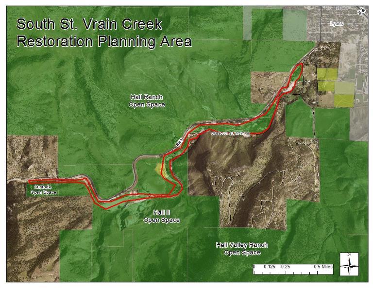
3
4 St. Vrain Creek Watershed Tier 1 - Projects reducing flood risk due to postflood conditions The purpose of this alternative is to implement a channel alignment that will optimize the interaction with completed, ongoing, and funded projects while being sensitive to the constraints presented by the presence of numerous private residences throughout this river corridor. The implementation of this alternative will expedite the maturation of this reach by re-establishing a natural channel, repairing erosion scars, reestablishing floodplain benches, building pointbars and excavating pools, re-vegetating denuded areas, and stabilizing channel banks. (p. 7-18)
5 St. Vrain Creek Watershed The also calls out the following restoration strategies for this reach (p to 7-25): Incorporate/stabilize a low flow channel section with lower width-to-depth ratio Increase in-stream habitat complexity by incorporating pools, boulders, rock clusters, and LWD (large woody debris) Revegetate riparian corridor with native species where needed However, the also states more detailed technical analysis and site specific survey and topographic information will further refine/revise the conceptual improvements reflected (in the ) (p to 7-25).
6 Funding Community Development Block Grant Disaster Recovery Planning Grant Grant = $295,000 Planning, surveys, engineering, public engagement, and up to 30% design for creek restoration Emergency Watershed Protection Program Eligible Projects 30% design complete by September 1, 2016 Construction ready by January 1, 2017 SSV 1 & SSV 2 = $1.6 million
7 Funding Spring 2016 Summer 2016 Planning and 30% Design* (CDBG-DR) Permitting & Environmental Clearance 100% Stream Design, as necessary Bidding & Contracting Implementation (EWP) days * Including Coalition and public engagement Fall 2016 Winter 2016 Spring 2017 Summer 2017 Fall 2017 Winter 2017

8
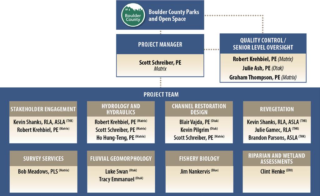
9 Matrix Fully integrated consulting firm Leaders in H&H analysis along with flood recovery Otak History of work in South St. Vrain Creek Watershed Leaders in resilient flood recovery solutions THK Native revegetation and riparian corridor restoration Leaders in public engagement and consensusbuilding
10 Design schedule Notice to proceed: May 2016 Alternative analysis: June 2016 Preferred alternative: July % design: August 2016 Final deliverable: September 2016 Public engagement meetings General public and St. Vrain coalition: Meetings in late May, June, and August

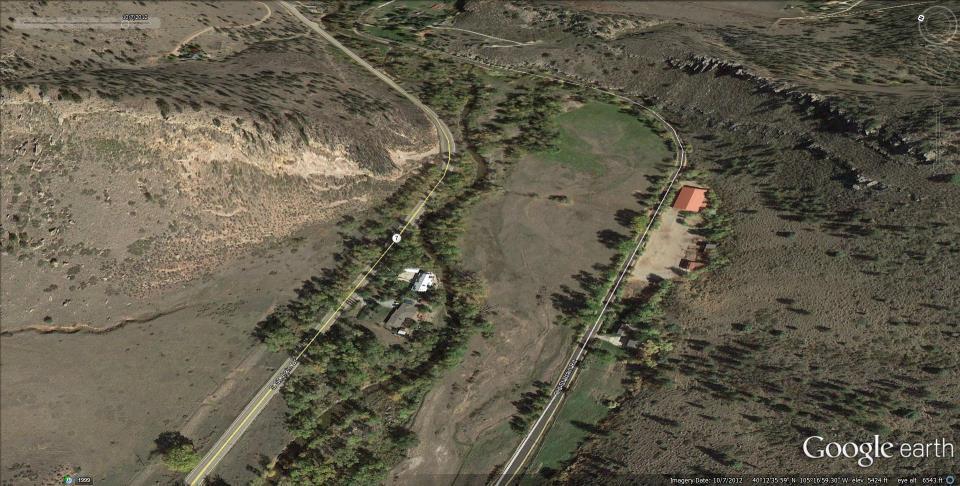
11 Pre Flood Aerial: 2012

12 Post Flood Aerial: 2013
13 Post Flood Aerial: 2014

14 Post Flood Aerial: 2015

15 Pre Flood Aerial: 2012

16 Post Flood Aerial: 2013

17 Post Flood Aerial: 2014

18 Post Flood Aerial: 2015

19 Pre Flood Aerial: 2012

20 Post Flood Aerial: 2013
21 Post Flood Aerial: 2014

22 Post Flood Aerial: 2015
23 General Reduce impact of future flooding Provide public safety Protect private and public infrastructure Re-establish floodplain connectivity Restore creek and surrounding areas
24 Execution Strategies Jumpstart return to healthy corridor: Reconnect floodplains Expedite maturation of native plant associations Restore aquatic and riparian health Risk reduction: Reduce impact of future flooding Protect private and public infrastructure Improve public safety : Neighbors and other stakeholders Boulder County
25 Execution Strategies - Jumpstart return to healthy corridor / Risk reduction: Review of Background/Existing Information Channel Forming Hydrology Channel Hydraulics Geomorphology Sediment Transport Aquatic and Terrestrial Habitat Permitting Process
26 Execution Strategies - Decision process: Review established project goals Community input to I.D. project issues Develop evaluation criteria Develop alternatives Community input on alternatives Alternatives analysis with evaluation criteria I.D. preferred alternative Community input on preferred alternative Refine preferred alternative with additional technical analysis 30% design Public presentation
27 General Reduce impact of future flooding Provide public safety Protect private and public infrastructure Re-establish floodplain connectivity Restore creek and surrounding areas
28 Figure A Monument Creek Watershed Restoration Decision Making Process Context Statement Core Values Critical Issues from Stakeholders Evaluation Criteria The Monument Creek Watershed includes square miles of forest and upland grass lands. The mountains meet the plans within the watershed which is why the United States Air Force Academy is located at the center of the watershed. The watershed is predominantly north of Colorado Springs and includes the communities of Monument and Palmer Lake. With a diversity of public and private ownerships, the watershed is a major regional tourist and recreation destination as well as home for a large percentage of El Paso County and Colorado Springs residents. The watershed is characterized by extremes in temperature and precipitation, large elevation changes, steep gradients and diverse ecosystems rich with plant life and wildlife. The recent summer of 2013 floods, coupled with the 2012 Waldo Canyon fire and the 2013 Black Forest fire, have resulted in considerable transport of sediment and debris. The floods altered the creek bed, banks, floodplains and structures and have led to extensive flood damage including property and infrastructure damage, erosion and sedimentation that resulted in a net loss of flood capacity. To identify strategies that will mitigate the effects of fire damage and flood damage in the watershed, a holistic restoration planning effort will provide effective and lasting protection of at risk assets, as well as the health, safety and welfare of the public. Safety Resiliency Constructability/Costs Environment Community Concern About Potential Forest Fires Concern About Potential Flooding 1. Reduces flood risk to the public and residents by providing long term solutions Public Health that increase resiliency? Actions in the Upper Watershed Effecting the Lower 2. Transfers risks or creates impacts downstream to infrastructure, channel and Watershed storm water system? Emergency Access 3. Number of people protected? Reduce Future Flood Damage Risk Provide Smarter Infrastructure Solutions Improve Creek Stability Risk to Critical Infrastructure 4. Physical area of watershed mitigated? 5. Critical Infrastructure at risk? Find Funding for Future Implementation 6. Creates infrastructure investments that are reasonable to construct and provides Fiscally Responsible Costs the best value for their lifecycle, function and purpose? Regional criteria, implementation and enforcement 7. Meets industry and local design standards? Long-term maintenance funding needed 8. Minimizes the effort required to maintain and repair the options? Minimize Maintenance Requirements and Costs 9. Compatible with forest fire mitigation? The impact of T&E species on constructability Reduce Future Sediment Loading and Hydrological Impacts to the Creek Due to 2012 and 2013 forest fires Reduce Sedimentation in General Improve Water Quality Including Turbidity, E. Coli and Debris Improve Wildlife Habitat (banking opportunities) Increase Channel Capacity to Accommodate future flooding Increase Storm Water Discharge Due to Development Work With Natural Systems Consistency with MS-4 requirements Presence of Endangered Species Introduction of new flow to the creek/volume change Detention ponds built to out dated design criteria Protect Infrastructure, Tourism and the Economy 10. Protects the habitat, water quality and geomorphology of Monument Creek? 11 Incorporates locally available materials and environmentally friendly processes? 12. Quantity of sediment reduced? 13. Consistent with MS-4 requirements? Concern About Increased Flood Insurance Costs Consider Greenway and Open Space Opportunities Communication with the Residents 14. Provides access and protects opportunities for enhancements to tourist destinations, Are the Historic CCC Structures of Value or a Risk to community facilities, features and neighborhoods? Future Flooding 15. Provides funding, partnering and collaboration opportunities by meeting multiple Need for better Flood Monitoring objectives? Collaboration Between Agencies and Communities 16. Can be supported by current land use regulations or revised land use regulations? Land Use Regulations and Management 17. Impacts to water rights? Impact on aesthetics (historical element of USAFA) Development Impact Economic injustice Impact to historic features Schedule Prioritize Strategies as Critical, Necessary or Desired
29 Decision Matrix Monument Creek Watershed Restoration Decision Matrix Draft 04/20/16 ID Criteria Evaluation Criteria Reduces flood risk to the public and residents by 1 providing long term solutions that increase resiliency? Avoids transfer of risks that create impacts 2 downstream to infrastructure, channel and storm water systems? 3 Number of people protected? 4 Physical area of watershed mitigated? 5 Critical Infrastructure at risk? Creates infrastructure investments that are reasonable to construct and provides the best value for their lifecycle, function and purpose? Meets or exceeds industry and local design standards? Minimizes the effort required to maintain and repair the options? Figure B Created utilizing the criteria identified in the Decision Making Flow Chat and a Fair/Better/Best ranking system Options Ranking Project A Project B Project C Fair Better Best 9 Compatible with forest fire mitigation? Protects or improves the habitat, water quality and geomorphology of Monument Creek? Incorporates locally available materials and environmentally friendly processes? 12 Quantity of sediment reduced? 13 Consistent with MS-4 requirements? Does it meet CWCB criteria for multi-objectives program elements? Provides access, connectivity and protects opportunities for enhancements to tourist destinations, community facilities, features and neighborhoods? Provides funding, partnering and collaboration opportunities by meeting multiple stakeholder objectives? Can be supported by current land use regulations or revised land use regulations?
30 Overall creek design Debris Andesite quarry Private residences along corridor Hall meadows / Split flow Longmont diversion Old South St Vrain Road bridge Ditches Additional Issues??
31 What s Next? Compilation of issue comments Develop evaluation criteria Develop alternatives Schedule next public meeting Post project up-dates to website
South St. Vrain / Hall Meadows Restoration Planning August 20, 2015
 South St. Vrain / Hall Meadows Restoration Planning August 20, 2015 Agenda Introductions Purpose & Goals of Meeting Planning Area Master Plan Restoration Planning: Cost Estimates, Grants, Scope, Timeline
Colorado Water Conservation Board Flood Recovery Update
 Colorado Water Conservation Board Flood Recovery Update Chris Sturm Stream Restoration Coordinator Colorado Water Conservation Board chris.sturm@state.co.us ORGANIZATIONAL CHART GOVERNOR DEPARTMENT OF
Request for Proposal Scope Development Guide. Asotin County Geomorphic Assessment. and. Conceptual Restoration Plan
 Request for Proposal Scope Development Guide Asotin County Geomorphic Assessment and Conceptual Restoration Plan Asotin County Conservation District December 3, 2015 1 1.0 INTRODUCTION The Asotin County
Beaver Creek Hydrology, LLC. Franklin, Tennessee
 Beaver Creek Hydrology, LLC. Franklin, Tennessee The Harpeth River Blueway Problems with Harpeth River EPA s 303(d) Listed for siltation, habitat alteration, nutrient enrichment and low dissolved oxygen
IMPROVING OUTCOMES FOR STREAM ALTERATION PROJECTS
 IMPROVING OUTCOMES FOR STREAM ALTERATION PROJECTS Bethany Matousek Inland Lakes and Streams Program Coordinator Wetlands, Lakes and Streams Unit DEQ Water Resources Division MatousekB@Michigan.gov 517-243-6421
Environment and Natural Resources Trust Fund 2015 Request for Proposals (RFP)
") Project Title: Total Project Budget: $ Environment and Natural Resources Trust Fund 2015 Request for Proposals (RFP) Flood Recovery on Sargent Creek Duluth Habitat Restoration Category: Proposed Project
Project Title: Total Project Budget: $ Environment and Natural Resources Trust Fund 2015 Request for Proposals (RFP) Flood Recovery on Sargent Creek Duluth Habitat Restoration Category: Proposed Project
2.4 Floodplain Restoration Principles
 Floodplain Restoration Principles 2.4 Floodplain Restoration Principles Anthropogenic alternation of river corridors and floodplains significantly modified the structure and function of landscapes and
Mountain States Chapter International Erosion Control Association Conference
 Mountain States Chapter International Erosion Control Association Conference November 5, 2015 Ian Paton, P.E, CFM Wright Water Engineers, Inc. Eliot Wong P.E., CFM Contech Engineered Solutions Hayes Lenhart,
Fires and Flash Flooding Federal Lands/Local Impact Waldo Canyon Fire Recovery Update: September Fall 2013
 Fires and Flash Flooding Federal Lands/Local Impact Waldo Canyon Fire Recovery Update: September 2013 Fall 2013 Started June 23, 2012, near Colorado Springs in western El Paso County Two people killed
Parks and Open Space 5201 St. Vrain Road Longmont, Colorado Fax:
 Parks and Open Space 5201 St. Vrain Road Longmont, Colorado 80503 303.678.6200 Fax: 303.678.6177 www.bouldercounty.org HALL RANCH 2 ACCESS ROAD REPAIRS Project Summary for Limited Impact Special Use Review
Meacham Creek Restoration Project
 Meacham Creek Restoration Project Meacham Creek Restoration Project Umatilla National Forest Walla Walla Ranger District Michael Rassbach, District Ranger Public Scoping Document Proposal Summary The Walla
4. Present Activities and Roles
 4. Present Activities and Roles The present missions, authorities, activities and roles of the various agencies involved with flood protection, floodplain management and flood-damage reduction are identified
May 15, Lower Squaw Creek Restoration Public Workshop. for The Friends of Squaw Creek Truckee River Watershed Council Sierra Nevada Conservancy
 Lower Squaw Creek Restoration Public Workshop for The Friends of Squaw Creek Truckee River Watershed Council Sierra Nevada Conservancy Prepared by: Mike Liquori May 15, 2008 Funding for this project has
Bylaw , being "Official Community Plan Bylaw, 2016" Schedule "A" 5Improve. Natural + Built Systems
 Bylaw 2600-2016, being "Official Community Plan Bylaw, 2016" Schedule "A" 5Improve Natural + Built Systems Vision Abbotsford will become both more city and more country, where the city becomes more urban
REPLACING CULVERTS FOR FLOOD RESILIENCY AND AQUATIC CONNECTIVITY. Cheryl Bondi and Lori Sommer NHDES Aquatic Resource Mitigation Program
 REPLACING CULVERTS FOR FLOOD RESILIENCY AND AQUATIC CONNECTIVITY Cheryl Bondi and Lori Sommer NHDES Aquatic Resource Mitigation Program How do stream crossings impact aquatic ecosystems and public safety?
BASIC PRINCIPLES AND MANAGEMENT GUIDELINES
 Chapter 1 BASIC PRINCIPLES AND MANAGEMENT GUIDELINES The overall goal of the management program for the Sacramento River Conservation Area (SB 1086) is to preserve remaining riparian habitat and reestablish
Bridging the Gap to Resilience Western Bridge Preservation Partnership Denver, CO May 23, 2017
 Bridging the Gap to Resilience Western Bridge Preservation Partnership Denver, CO May 23, 2017 Presenter Heather Paddock, PE Region 4 Central Program Engineer and Flood Recovery Manager heather.paddock@state.co.us
A collaborative strategy for optimizing management of the river corridor. Wednesday, June 2, 2010
 A collaborative strategy for optimizing management of the river corridor. Wednesday, June 2, 2010 Lower Feather River CMP Overview Map The Aerial Photo of the entire Big Picture Lower Feather River CMP
Drainage Criteria Manual Review
 City of Colorado Springs Stormwater Management Assessment and Standards Development Drainage Criteria Manual Review March 8, 2013 Springsgov.com/City Agencies/Stormwater/Stormwater Engineering/ Stormwater
Municipal Class Environmental Assessment for Pottersburg Creek Slope Stability Study South of Hamilton Road, Schedule B
 Municipal Class Environmental Assessment for Pottersburg Creek Slope Stability Study South of Hamilton Road, Schedule B February 13, 2013 Municipal Class EA Process We are here Purpose and Objective of
Prioritizing Local Action. Strengthening the Resilience of the Taunton River Watershed
 Prioritizing Local Action Strengthening the Resilience of the Taunton River Watershed No Really, We re Here to Help 6/12/14 Healthy and Resilient Taunton Watershed Project EPA s Healthy Watershed Program
STREAM RESTORATION PURPOSE, PRACTICE, AND METHODS. By Marcus Rubenstein, CPESC
 STREAM RESTORATION PURPOSE, PRACTICE, AND METHODS By Marcus Rubenstein, CPESC WHAT IS STREAM RESTORATION? The return of a stream s lost natural functions, usually resulting from watershed alterations,
IAFSM 2010 Annual Conference. City of Rockford Keith Creek Greenway Flood Mitigation Project
 IAFSM 2010 Annual Conference City of Rockford Keith Creek Greenway Flood Mitigation Project March 10, 2010 Introduction Problem Overview 1890 s Building of homes along Keith Creek 1920 s Home construction
APPENDIX H JOINT PUBLIC NOTICE
 APPENDIX H JOINT PUBLIC NOTICE DEPARTMENT OF THE ARMY SAVANNAH DISTRICT, CORPS OF ENGINEERS 100 W. OGLETHORPE AVENUE SAVANNAH, GEORGIA 31401-3604 August 17, 2016 JOINT PUBLIC NOTICE U.S. Army Corps of
How Much Habitat Is Enough? How Much Disturbance is Too Much?
 How Much Habitat Is Enough? How Much Disturbance is Too Much? Jocelyn Sherwood Canadian Wildlife Service - Ontario January 27 th, 2017 Page 2 April 19, 2017 Page 3 April 19, 2017 Grasslands Forest Wetlands
Funding Guidelines State Fiscal Year 2016
 State Fiscal Year 2016 Water Quality Financial Assistance Centennial Clean Water Program Clean Water Act Section 319 Program Stormwater Financial Assistance Program Washington State Water Pollution Control
Support legislation that will protect the quantity of water in Lake Erie
 Specific Regional Priorities Each of Pennsylvania s major drainage basins has an array of individual characteristics that distinguish it from other regions of the state. These include diverse geographic
Scoping Study for Upper Petaluma River Watershed Flood Control Project. Frequently Asked Questions
 Scoping Study for Upper Petaluma River Watershed Flood Control Project Frequently Asked Questions December 8, 2011 1. Why was the public not notified of the April 28 meeting? The April 28 meeting was intended
Local Flood Hazard Mitigation Program. A framework for hazard mitigation in the NYC West of Hudson Water Supply Watersheds
 Local Flood Hazard Mitigation Program A framework for hazard mitigation in the NYC West of Hudson Water Supply Watersheds Flood Hazard Mitigation Defined 2 2 Presentation Overview Why and how is the NYC
RIPARIAN CORRIDOR STUDY FINAL PARLEYS CREEK MANAGEMENT PLAN TABLE OF CONTENTS
 TABLE OF CONTENTS 1.0 INTRODUCTION... 1-1 Riparian Corridor Study and Management Plan Goals... 1-1 Study Area... 1-2 Importance and Functions of Riparian Corridors... 1-2 Habitat for Mammals, Birds, and
Background. AEM Tier 2 Worksheet Stream & Floodplain Management. Glossary
 AEM Tier 2 Worksheet Stream & Floodplain Management Glossary Bankfull Stage: The stage at which water starts to flow over the flood plain; the elevation of the water surface at bankfull discharge. (This
Sustainable Post Disaster Recovery
 Sustainable Post Disaster Recovery May 14, 2013 4 PM Lucinda Andreani & Dustin Woodman Coconino County Public Works (Arizona) 1 Presenters Lucinda Andreani, Deputy Director, Coconino County Public Works
Post-Fire BAER Assessment Burned Area Emergency Response (BAER)
") November 2017 Post-Fire BAER Assessment Burned Area Emergency Response (BAER) Information Brief Diamond Creek Fire Values at Risk Matrix and Treatments CentralWashingtonFireRecovery.info EMERGENCY DETERMINATION
November 2017 Post-Fire BAER Assessment Burned Area Emergency Response (BAER) Information Brief Diamond Creek Fire Values at Risk Matrix and Treatments CentralWashingtonFireRecovery.info EMERGENCY DETERMINATION
Watershed Hydrology: Go with the flow. Greg Jennings, PhD, PE
 Watershed Hydrology: Go with the flow Greg Jennings, PhD, PE jenningsenv@gmail.com Streams What are your CHALLENGES? Hydrology too much water Pollutants upstream and on-site Vegetation wrong plants, wrong
Restoration of Riparian Forests and Riparian Ecosystem Processes and Implications for Salmon Restoration. Katie Ross-Smith Jennifer Hammond
 Restoration of Riparian Forests and Riparian Ecosystem Processes and Implications for Salmon Restoration Katie Ross-Smith Jennifer Hammond Outline > Background California riparian communities Riparian
DEVELOPING A WATERSHED IMPROVEMENT PLAN TO MEET MULTIPLE COMMUNITY OBJECTIVES IN GAINESVILLE AND HALL COUNTY, GEORGIA
 DEVELOPING A WATERSHED IMPROVEMENT PLAN TO MEET MULTIPLE COMMUNITY OBJECTIVES IN GAINESVILLE AND HALL COUNTY, GEORGIA Chrissy, Thom 1, David Dockery 2, Kevin McInturff 3, Betsy Massie 1, and Lauren Murphy
Don t Mow. Let it Grow!
 Don t Mow. Let it Grow! The Science Behind the Need for Riparian Buffer Protection. Chelsea Walker, WCD Watershed Specialist chelsea@wcdpa.com 724-837-5271 What is a Riparian Buffer? A riparian buffer
The F.O.R.C.E. The Future Of Redwood Creek Environment
 The F.O.R.C.E. The Future Of Redwood Creek Environment Robert Andersen Katelyn Csatari Achyuth Madabhushi Julie Swanson Overview Mission Statement Watershed Characterization Land and Water Use History
No Adverse Impact Floodplain Management
 No Adverse Impact Floodplain Management June 6, 2013 Beth Lucas, Senior Planner Broome County Planning No Adverse Impact Developed by Association of State Floodplain Managers Purposes: Address the shortcomings
RIPARIAN CORRIDOR STUDY FINAL CITY CREEK MANAGEMENT PLAN TABLE OF CONTENTS
 TABLE OF CONTENTS 1.0 INTRODUCTION... 1-1 Riparian Corridor Study and Management Plan Goals... 1-1 Study Area... 1-2 Importance and Functions of Riparian Corridors... 1-2 Habitat for Mammals, Birds, and
7.0 WATER-BASED CONTROL MEASURES
 7.0 WATER-BASED CONTROL MEASURES 7.1 IDENTIFICATION AND DESCRIPTION OF CONTROL MEASURES Table 7-1 lists the water-based options being considered for implementation in the initial screening stage. Descriptions
Primer introduction to watershed management Plan Process highlight the major steps of plan development Project types look at some examples of common
 1 Primer introduction to watershed management Plan Process highlight the major steps of plan development Project types look at some examples of common projects Plan Organization how to read the plan Next
Section 6: Stormwater Improvements
 Section 6: Stormwater Improvements A major objective of this study was to identify opportunities for improvements to address the widespread water quality impairments caused by stormwater runoff in the
COASTAL CONSERVANCY. Staff Recommendation March 25, 2004 NCCP PROGRAM IMPLEMENTATION: SAN DIEGO RIVER CALMAT PROPERTY PHASE 2
 COASTAL CONSERVANCY Staff Recommendation March 25, 2004 NCCP PROGRAM IMPLEMENTATION: SAN DIEGO RIVER CALMAT PROPERTY PHASE 2 File No. 03-137 Project Manager: Marc Beyeler RECOMMENDED ACTION: Authorization
Climate Smart Resiliency Plans, Policies, and Projects Improvement Plan for: The Town of Caroline
 Climate Smart Resiliency Plans, Policies, and Projects Improvement Plan for: The Town of Caroline Overview This document should serve as a supplement to the Climate Smart Resiliency Planning Evaluation
Chapter 4 Watershed Goals and Objectives
 Chapter 4 Watershed Goals and Objectives Eight (8) long-term watershed goals have been developed by the NEW Watershed Advisory Group (WAG) after consideration of discussions held during monthly watershed
Stinson Beach Watershed Program
 Stinson Beach Watershed Program www.marinwatersheds.org Purpose The Board of Supervisors authorized the Department of Public Works to begin implementation of a County-wide Watershed Program on May 13,
Waldo Canyon Fire Post-Fire Flash Flood Recovery. Fall Sallie Clark Former County Commissioner El Paso County, CO
 Waldo Canyon Fire Post-Fire Flash Flood Recovery Fall 2013 Sallie Clark Former County Commissioner El Paso County, CO El Paso County Disaster Recovery OVERVIEW Declared Disasters: June 2012 - Waldo Canyon
Chehalis Basin Strategy Programmatic SEPA Draft EIS
 Chehalis Basin Strategy Programmatic SEPA Draft EIS History of Flooding I-5 closed in 1990, 1996, 2007, 2009 Five largest flood events occurred since 1986 2 History of Habitat Degradation Harvest has been
Toronto and Region Conservation 2017 Progress & 2018 Budget Peel Council
 Toronto and Region Conservation 2017 Progress & 2018 Budget Peel Council November 16, 2017 1 2 Input $4,248,000 44 Projects Activities Watershed 2017 Output Increased coverage of Flood Monitoring and Real
HYDROLOGY, WATER USE, AND INFRASTRUCTURE
 HYDROLOGY, WATER USE, AND INFRASTRUCTURE Water resources in the Blue Mountains are valued for fisheries and other aquatic biota, recreation, municipal and residential use, vegetation, agriculture, and
Chapter 5: Water Quality Buffer Requirements
 Chapter 5: Water Quality Buffer Requirements 5.1 Introduction Water quality buffer requirements apply to all new land development or redevelopment containing streams or other water bodies such as ponds,
Narragansett Bay and Watershed Restoration Bond Fund
 Narragansett Bay and Watershed Restoration Bond Fund 1) Govt. Entities Nonpoint Source Water Pollution Control Fund 2) Non-Govt. Non-point Source Water Pollution Control Fund 3) Riparian Buffer Restoration
CATEGORY a protection of the natural environment, its ecosystems and biodiversity.
 29. ENVIRONMENTAL DEVELOPMENT PERMIT AREA CATEGORY a protection of the natural environment, its ecosystems and biodiversity. The requirement to obtain an environmental development permit is cited in Section
ANCR INDIVIDUAL RESPONSES SUMMARY: 2/11/04 WATER RESOURCES GOALS AND OBJECTIVES
 ANCR INDIVIDUAL RESPONSES SUMMARY: 2/11/04 WATER RESOURCES GOALS AND OBJECTIVES Goal 1: Protect the health and safety of the Dane County population. a. Prevent development that may have an adverse effect
MONTEREY PENINSULA WATER MANAGEMENT DISTRICT PROJECT DESCRIPTION FOR SELECTIVE VEGETATION MANAGEMENT AND BANK RESTORATION (RANCHO SAN CARLOS AREA)
") MONTEREY PENINSULA WATER MANAGEMENT DISTRICT PROJECT DESCRIPTION FOR SELECTIVE VEGETATION MANAGEMENT AND BANK RESTORATION (RANCHO SAN CARLOS AREA) IN THE CARMEL RIVER CHANNEL, SUMMER AND FALL 2014 SELECTIVE
MONTEREY PENINSULA WATER MANAGEMENT DISTRICT PROJECT DESCRIPTION FOR SELECTIVE VEGETATION MANAGEMENT AND BANK RESTORATION (RANCHO SAN CARLOS AREA) IN THE CARMEL RIVER CHANNEL, SUMMER AND FALL 2014 SELECTIVE
RE: Recommendations for Staged Implementation of Alternative 3a
 March 10, 2006 Ms. Julie Thomas Coastal San Luis Resource Conservation District 545 Main Street, Suite B-1 Morry Bay, Ca 93442 RE: Recommendations for Staged Implementation of Alternative 3a Dear Ms. Thomas,
The Beckett s Run Experience. Fort Wayne, Indiana
 The Beckett s Run Experience Fort Wayne, Indiana Introductions Charlie Cochran City of Fort Wayne, Wet Weather Storm & Sewer Engineering Jason Durr, PE Christopher B. Burke Engineering, LLC 2 A Little
Thief River One Watershed One Plan Prioritization Matrix Prioritization of Issues
 Thief River One Watershed One Plan Prioritization Matrix Prioritization of Issues The Prioritization Matrix is a categorized table that lists the issues that were compiled for the Thief River watershed,
Chapter 5. Natural Features. Environmental Management Mode Land Resources Water Resources Air Quality Preparing for Climate Change
 Chapter 5 Natural Features Natural Features Environmental Management Mode Land Resources Water Resources Air Quality Preparing for Climate Change 5.1 NATURAL FEATURES BACKGROUND Maple Ridge encompasses
BMP 5.4.2: Protect /Conserve/Enhance Riparian Areas
 BMP 5.4.2: Protect /Conserve/Enhance Riparian Areas The Executive Council of the Chesapeake Bay Program defines a Riparian Forest Buffer as "an area of trees, usually accompanied by shrubs and other vegetation,
Bluff Creek One Water
 Bluff Creek One Water The Bluff Creek Watershed has no lakes within its boundaries. As the westernmost watershed within the District, land use changes from agricultural to residential have occurred relatively
COON CREEK WATERSHED DISTRICT PERMIT REVIEW
 16-054 Woodland Creek Wetland Banking Restoration Project, Page 1 of 6 COON CREEK WATERSHED DISTRICT PERMIT REVIEW MEETING DATE: August 22, 2016 AGENDA NUMBER: 11 FILE NUMBER: 16-054 ITEM: Woodland Creek
Wood-Pawcatuck Watershed Flood Resiliency Management Plan
 Wood-Pawcatuck Watershed Flood Resiliency Management Plan Project Steering Committee Kickoff Meeting March 26, 2015 Wood-Pawcatuck Watershed Association Meeting Agenda 10:00 10:05 Welcome and Opening Remarks
US ARMY CORPS OF ENGINEERS ACTIONS DURING 2016 TEXAS SPRING FLOOD
 1 US ARMY CORPS OF ENGINEERS ACTIONS DURING 2016 TEXAS SPRING FLOOD 237 237 237 217 217 217 200 200 200 80 119 27 252 174.59 255 255 255 0 0 0 163 163 163 131 132 122 239 65 53 110 135 120 112 92 56 62
GETTING STARTED: LEVERAGING FUNDING SOURCES TO CREATE OPPORTUNITIES KAMM CONFERENCE August 24, 2016 Presented By: Sarah Taylor
 GETTING STARTED: LEVERAGING FUNDING SOURCES TO CREATE OPPORTUNITIES 2016 KAMM CONFERENCE August 24, 2016 Presented By: Sarah Taylor OVERVIEW Do I really have a problem? Identifying the need Finding the
A Freshwater Blueprint for Maritime Canada
 A Freshwater Blueprint for Maritime Canada Union of Nova Scotia Municipalities (UNSM) November 8 th, 2017 William Millar Aquatic Conservation Biologist william.millar@natureconservancy.ca Craig Smith Conservation
Management Objectives and Targets
 Management Objectives and Targets As part of the Yampa River Stream Management Plan, the community of Steamboat Springs developed management objectives for the reach of the Yampa River near Steamboat Springs.
DECISION MEMO. West Fork Blacktail Deer Creek Hardened Crossing
 Page 1 of 6 Background DECISION MEMO USDA Forest Service Madison Ranger District Madison County T12S, R4W, Section 30 The project is in the Gravelly Landscape, Snowcrest Recommended Wilderness Management
Public Notice ISSUED: 5/6/2014 EXPIRES: 6/5/2014
 APPLICANT: Kinghorn Company / Scannell Properties Public Notice ISSUED: 5/6/2014 EXPIRES: 6/5/2014 REFER TO: 2014-00724-MMJ SECTION:404 - Clean Water Act 1. APPLICATION FOR PERMIT TO discharge fill material
City of Fairmont Storm Water Pollution Prevention Plan Annual Public Meeting. June 11, 2018
 City of Fairmont Storm Water Pollution Prevention Plan Annual Public Meeting June 11, 2018 Why is Water Quality Important? Water has always been important to Minnesota and is a key part of our history,
CHESAPEAKE BAY COMPREHENSIVE WATER RESOURCES AND RESTORATION PLAN - UPDATE. Update to Chesapeake Bay Program STAR January 25, 2018
 CHESAPEAKE BAY COMPREHENSIVE WATER RESOURCES AND RESTORATION 255 255 255 237 237 237 0 0 0 217 217 217 163 163 163 200 200 200 PLAN - UPDATE 131 132 122 239 65 53 80 119 27 110 135 120 252 174.59 112 92
STAFF REPORT FOR POLICY PLAN AMENDMENT S10-CW-1CP
 STAFF REPORT FOR POLICY PLAN AMENDMENT S10-CW-1CP EXECUTIVE SUMMARY This Plan Amendment would serve to clarify policy guidance regarding circumstances under which proposals for disturbances to Environmental
Riparian Buffer Restoration Fund. Gregg J. Cassidy RI DEM, Sustainable Watersheds Office
 Riparian Buffer Restoration Fund Gregg J. Cassidy RI DEM, Sustainable Watersheds Office Narragansett Bay and Watershed Restoration Bond Fund 1) Govt. Entities Nonpoint Source Water Pollution Control Fund
Reclaiming Seiad Creek Part 1
 Reclaiming Seiad Creek Part 1 After 100+ Years of Placer Mining Presented by: Jason E. Poulsen May 4, 2016 Montana Tech Mine Design, Operation & Closure Conference Badges? We ain t got no badges... We
C. Staffing Needs Approximately 150 staff days TSA #3 staff time will also be utilized.
 2017 Annual Plan I. Introduction The purpose of this annual plan is to detail work items that will be completed in 2017. The annual plan will provide a tool for SWCD staff and supervisors to evaluate program
Juncrock Timber Sale Draft Environmental Impact Statement. Appendix G Soils
 Juncrock Timber Sale Draft Environmental Impact Statement Appendix G Soils Soil Condition Monitoring on the Barlow Ranger District of the Mt. Hood National Forest 1999 The Barlow Ranger District conducts
NRCS Programs and Practices for Riparian Areas in Hawaii
 NRCS Programs and Practices for Riparian Areas in Hawaii NRCS Pacific Islands Area Hawaii - State (State (PIA) Office Honolulu, Oahu) Seven field offices (Kauai, Oahu, Molokai, Maui, Hawaii) Plant Materials
Small Project Proposal
 Combined Scoping and Notice and Comment Document Small Project Proposal USDA Forest Service Fishlake National Forest Beaver Ranger District Sevier County, Utah The purpose of this document is to inform
DECISION MEMO FOR CATEGORICAL EXCLUSION HOLY JIM CREEK CROSSING REPLACEMENT
 DECISION MEMO FOR CATEGORICAL EXCLUSION HOLY JIM CREEK CROSSING REPLACEMENT U.S.D.A. Forest Service Cleveland National Forest Trabuco Ranger District Orange County, California Background The current configuration
Restoring Ecological & Geomorphic Function on the Heartrock Ranch
 Restoring Ecological & Geomorphic Function on the Heartrock Ranch DAVE ROSGEN BRANDON ROSGEN WILDLAND HYDROLOGY FORT COLLINS, COLORADO RIVER RESTORATION 2018, TWO HARBORS, MN OCTOBER 29 TH, 2018 Cooperators
Warren Wagon Road Improvement Project McCall Ranger District, Payette National Forest Project Description
 Warren Wagon Road Improvement Project McCall Ranger District, Payette National Forest Project Description Introduction The analysis of the Warren Wagon Road Improvement Project is tiered to the 2003 Environmental
Environmental Assessment
 United States Department of Agriculture Forest Service May 2009 Environmental Assessment Powder River Campground Decommissioning Powder River Ranger District, Bighorn National Forest Johnson and Washakie
Spatially prioritizing fuel treatments to manage wildfire risks to municipal watersheds
 Spatially prioritizing fuel treatments to manage wildfire risks to municipal watersheds Benjamin Gannon 1,2, Yu Wei 2, Stephanie Kampf 3, Lee MacDonald 3, Jeff Cannon 1, Brett Wolk 1, Tony Cheng 1,2, Kelly
Technical, Political, and Environmental Requirements of Transbasin Diversions
 Technical, Political, and Environmental Requirements of Transbasin Diversions Brian Werner, Northern Water Becky Mitchell, Colorado Water Conservation Board Casey Funk, Denver Water Colorado Transbasin
Downtown Estes Loop Project Frequently Asked Questions
 May 15 th, 2015 Project Status 1) Has Alternative 1 already been selected? Is it a done deal? Response: The NEPA process will proceed with environmental analysis of both the No Action and Alternative 1.
Meacham Creek Fish Habitat Enhancement: Application of the CTUIR River Vision
 Meacham Creek Fish Habitat Enhancement: Application of the CTUIR River Vision Future of Our Salmon A Vision of Restoration in the Columbia River Basin June 1, 2011 James Webster Confederated Tribes of
Town of Aurora Stream Management Master Plan PUBLIC INFORMATION CENTRE May 1 st, 2018
 Town of Aurora Stream Management Master Plan PUBLIC INFORMATION CENTRE May 1 st, 2018 Your comments are encouraged and appreciated, as this will provide us an opportunity to address project issues and
Public Information Centre September 19 th, 2017
 Public Information Centre September 19 th, 2017 WELCOME! Public Information Centre for the Maple Hill Creek Rehabilitation Class Environmental Assessment Please take the time to sign our sign in sheet
Chapter 10 Natural Environment
 Chapter 10 Natural Environment Existing Conditions The Natural Environment Element addresses the protection, conservation, preservation, and restoration of the natural resources the Bayview Ridge Subarea,
Small Project Proposal
 Scoping Document Small Project Proposal USDA Forest Service Fishlake National Forest Beaver Ranger District Beaver County, Utah The purpose of this document is to inform you of a new individual small project
INDIAN CREEK WATERSHED PLAN EXECUTIVE SUMMARY
 INDIAN CREEK WATERSHED PLAN EXECUTIVE SUMMARY The Indian Creek Watershed covers a 38 square mile area in southern Lake County, Illinois that drains 24,116 acres before discharging into the Des Plaines
PROJECT SCREENING MATRIX: A User s Guide
 Version 2.0 Page 1 of 7 November 9, 2010 PROJECT SCREENING MATRIX: A User s Guide BACKGROUND The Project Screening Matrix (Screening Matrix) is one of several tools that comprise the River Restoration
Stream Corridor Stewardship & Management Planning
 Stream Corridor Stewardship & Management Planning Presentation by: Shelly Johnson-Bennett, DC Planning Department Wayne Reynolds, DC Department of Public Works Purpose To enhance stream corridor stewardship
Ingram Gulch Drainage 30% Design Report
 Ingram Gulch Drainage 30% Design Report Submitted to: Four Mile Watershed Coalition Project Number: 970-1 Date: March 13, 2017 Norwest Corporation 950 South Cherry Street, Suite 800 Denver, Colorado 80246
Appendix B Stormwater Site Plan Submittal Requirements Checklist
 Stormwater Site Plan Submittal Requirements Checklist The Submittal Requirements Checklist is intended to aid the design engineer in preparing a Stormwater Site Plan. All items included in the following
Get the Rock Out: Engineered wood structures for stream restoration. Joe Berg, Doug Streaker, Matt Koozer and Kevin Nunnery Biohabitats, Inc.
 Get the Rock Out: Engineered wood structures for stream restoration Joe Berg, Doug Streaker, Matt Koozer and Kevin Nunnery Biohabitats, Inc. Examples of Wood Structures in Stream Design Root wads one of
Water Quality Stewardship Plan (WaQSP)
") Salt Lake Countywide Water Quality Stewardship Plan (WaQSP) Natalie Rees Salt Lake County Flood Control & Engineering Division 2008 Watershed Symposium COUNTY RESPONSIBILITY AND AUTHORITY Salt Lake County
Salt Lake Countywide Water Quality Stewardship Plan (WaQSP) Natalie Rees Salt Lake County Flood Control & Engineering Division 2008 Watershed Symposium COUNTY RESPONSIBILITY AND AUTHORITY Salt Lake County
Flood Mitigation Plan
 City of Huntsville, Alabama Flood Mitigation Plan 2001 Prepared by Flood Mitigation Planning Committee June 1, 2001 City of Huntsville, Alabama Flood Mitigation Plan Executive Summary 1973 1999 Prepared