Aitkin Wetland Mitigation Site
|
|
|
- Heather Preston
- 6 years ago
- Views:
Transcription

1 Aitkin Wetland Mitigation Site Wetland Mitigation Plan Poly Met Mining Inc. May 2014
2 Aitkin Wetland Mitigation Site Wetland Mitigation Plan May 2014 Contents 1.0 Introduction Wetland Mitigation Crediting Wetland Mitigation Goals Shallow Marsh Shrub-Carr Hardwood Swamp Coniferous Swamp Wetland Mitigation Performance Standards General Performance Standards Hydrology Shallow Marsh Shrub-Carr Hardwood Swamp Conifer Swamp Vegetation Shallow Marsh Growing Season Growing Season Growing Season Growing Seasons Shrub-Carr Growing Season Growing Season Growing Season Growing Seasons Hardwood Swamp Growing Season Growing Season i
3 4.6.3 Growing Season Growing Seasons Coniferous Swamp Growing Season Growing Season Growing Season Growing Seasons Upland Buffer Growing Season Growing Season Growing Season Growing Seasons Wetland Restoration Site Description Aitkin Wetland Mitigation Site Description Geology and Soils East Area Soils West Area Soils Topography Climate Hydrology Hydrology Monitoring Wetland Delineation Wetland Restoration Plan Aitkin Wetland Restoration Construction Plan Vegetation Restoration Establishment General Site Preparation Natural Regeneration - All Communities Seeding/Planting - Shallow Marsh and Shrub-Carr Communities Planting Hardwood Swamp Community Seeding/Planting Coniferous Swamp Community Upland Area Establishment Wetland Management Schedule Year ii
4 7.1.1 Fall/Winter Spring/Summer Year Fall End of First Full Growing Season Spring/Summer Year Fall End of Second Full Growing Season Spring/Summer Years Years Wetland Mitigation Monitoring Hydrologic Monitoring Years Shallow Marsh All Other Communities Hydrologic Monitoring Years All Other Communities Vegetation Monitoring Monitoring Report References...31 iii
5 List of Tables Table 1 Table 2 Table 3 Wetland Mitigation Credit Summary Wetland Mitigation Target Community Summary Potentially Problematic Invasive Species List of Figures Figure 1 Figure 2 Figure 3 Figure 4 Figure 5 Figure 6 Figure 7 Figure 8 Wetland Restoration Plan Wetland Mitigation Credit Areas Soils Wetland Delineation National Wetland Inventory Site Drainage Area 1940 Aerial Photo 1991 Aerial Photo List of Appendices Appendix A Appendix B Permanent Conservation Easement Example Soil and Water Transect Data iv
6 1.0 Introduction On behalf of Poly Met Mining Inc. (PolyMet), Barr Engineering Co. has prepared this wetland restoration plan to provide compensatory wetland mitigation to replace unavoidable wetland impacts associated with PolyMet s NorthMet Project (Project). The Project site is located in the St. Louis River #3 major watershed and a total of 939 acres of wetland impacts are proposed. The compensatory mitigation activities described in this report include those planned within one site located near Aitkin, Minnesota in Aitkin County. The Aitkin mitigation location is the site of an active sod production facility that encompasses approximately 1,070 acres of land, on which, 808 acres of wetland restoration and 83 acres of upland buffer preservation is proposed (Figure 1). The site is located in the Mississippi River-Brainerd #10 major watershed. PolyMet has entered into an option agreement with the landowner formalizing the intent to conduct wetland restoration activities. This report includes discussions of the restoration site, construction activities, vegetation establishment and management activities, wetland restoration goals, performance standards, schedules, and monitoring plans. A preliminary wetland restoration plan was submitted to the U.S. Army Corps of Engineers (USACE) and Minnesota Department of Natural Resources (MDNR) Division of Lands and Minerals in August The plan was reviewed by the USACE, MDNR, and MPCA; comments were provided, and the plan was resubmitted for review. A final review was conducted by the same agencies and a final plan was submitted in January A revised permit application was submitted to the USACE and MDNR in August 2013 to start the permitting process. The agencies determined that hydrologic monitoring should be conducted to justify the proposed crediting in the plan and the plans should be revised to comply with standards that have changed since the initial submittal. Therefore, this plan was developed to comply with the current Wetland Conservation Act (WCA) rules (Minnesota Rules Chapter 8420) as administered by the Minnesota Department of Natural Resources Division of Lands and Minerals, Section 404 of the Clean Water Act as administered by the USACE, and Minnesota Rules (wetland mitigation) as administered by the Minnesota Pollution Control Agency. Permanent Conservation Easements similar to the example provided in Appendix A will be prepared and recorded to cover the wetland restoration and associated upland buffer areas within one year after starting the restoration activities at the site. 1
7 2.0 Wetland Mitigation Crediting Because the wetland mitigation site included in this plan is located outside of the project watershed, all mitigation associated with this plan will be conducted at a ratio of 1.25:1 or 1.5:1 in accordance with USACE guidance. Current guidance from the USACE regarding conditions that constitute in-advance compensatory mitigation was provided in a memo dated May 29, Restoration successfully completed following the guidance in that memo and comprised of the same type as the impacted wetlands will be credited at a 1.25:1 ratio and replacement out-of-kind will be credited at a 1.5:1 ratio. Should in-kind compensatory mitigation be deemed unsuccessful such that an equal area of in-kind replacement is not provided for the impacts, those impacts will be replaced at a 1.5:1 ratio. Wetland replacement completed at the site will be required at a 1.5:1 ratio in accordance with the WCA, because it is located outside of the project watershed. Should additional wetland mitigation credits be established beyond the needs for direct impacts, the excess credits will be utilized to compensate for indirect wetland impacts. The proposed wetland replacement credit areas are shown in Figure 2. The credits were calculated based on: Hydrology monitoring (Reference (1)) Soil survey information (Figure 3) Target plant communities (Figure 1) developed based on existing elevations, proposed elevations, and planned hydrologic restoration Existing wetland boundaries (Figure 4) Other site conditions These credits are summarized in Table 1 based on actions eligible for credit in the USACE s policy (2009) for wetland mitigation in Minnesota and in the WCA rules. Proposed actions eligible for credit include the following with references to the applicable USACE s policy (2009) and subpart under the WCA Chapter : Upland buffer credit [Section 404 (upland buffers) and WCA-Subp. 2] is applied to areas that are not expected to develop as wetland after restoration is complete. These areas will be restored to native, non-invasive vegetation. Upland buffer credits are credited at 25% of the area maintained as upland buffer (4:1 ratio of upland acres to credit). Credit from upland buffers will not exceed 25% of the total credit from the site. A total of 83.2 acres of upland buffer and 20.8 credits are estimated to result from the proposed wetland restoration work (Table 1). Credit for restoration of completely drained wetlands [Section 404 (restoration via reestablishment) and WCA-Subp. 3] is applied to the majority of the wetland restoration areas on the site presently under cultivation. The estimated area of wetland that is expected to develop is discussed in Section 7.0. Areas that are presently non-wetland and develop as wetland after restoration are proposed as 100% credit for the area restored (1:1; wetland to credit). An 2
8 Table 1 estimated acres of drained wetland are planned to be restored with the project for credits (Table 1). Restoration of partially-drained wetland [Section 404 (restoration via rehabilitation) and WCA- Subp. 4] currently applies to the wetland in the northwest portion of the site located east of Highway 1 (Figure 2). Hydrology monitoring in documented that this area is partiallydrained by the drainage system managed throughout the site. The minimum wetland hydrology criteria were met in both years of monitoring, but the duration was only 12 percent to 26 percent of that documented within the reference wetland. Restoration will restore natural hydrology to this wetland by removing the drainage system. This would qualify as credit for restoration via rehabilitation under the USACE s policy (Reference (2)) and is proposed for 50% credit of the area restored (2:1; wetland to credit). The partially-drained wetland area encompasses 50.0 acres for 25.0 credits (Table 1). Wetland Mitigation Credit Summary Restoration Method Area (acres) Percent Credit Credits Upland buffers % 20.8 Partially-drained wetlands % 25.0 Restoration of drained wetlands % Total for Site All of the private ditch wetlands within the site, encompassing 31.5 acres, will be filled to eliminate drainage effects. Those areas will remain wetland and are proposed to receive no credit. The areas within the Diversion Channel easement are not proposed for credits because those areas may be modified by the local ditch authority in the future to manage regional drainage. No credits are proposed for areas within the County Highway 1 right-of-way. In order to adequately track the timing of wetland mitigation construction and wetland impacts, a structured accounting system may be needed to determine the required mitigation ratios. This information could be provided in the MDNR Permit to Mine annual report. The annual report could include a tabulation of wetland mitigation that was constructed, including the dates when construction was completed and wetland impacts that occurred by December 31 of each year. This information would be submitted using the schedule for the Permit to Mine annual report, typically within one month after the end of the year. 3
9 3.0 Wetland Mitigation Goals To the degree feasible, the primary goal of the wetland mitigation plan for PolyMet is to restore high quality wetland communities (Reference (3)) of the same types as those impacted by the project. While it is not practicable to replace all impacted wetland types with an equivalent area of in-kind wetland due to site limitations, technical feasibility, and other considerations; the goal of the mitigation plan is to replace the wetland types in-kind to the degree practicable in order to replace lost wetland functions and values. A summary of the acreage of each targeted wetland restoration community is provided in Table 2. A total of acres of wetland restoration is proposed (Figure 1), including four wetland community types that are planned to replace impacts in-kind to the degree practicable, constrained by the restoration of wetland types that are ecologically suitable and sustainable for the landscape area. Table 2 Wetland Mitigation Target Community Summary Targeted Plant Community Area (acres) Credit Shallow Marsh Shrub-Carr Hardwood Swamp Conifer Swamp Wetland Total Upland Buffer Total for Site Detailed descriptions of the targeted wetland communities within the wetland restoration area are provided in the following sections. 3.1 Shallow Marsh A total of 39.2 acres of shallow marsh wetland is planned in two areas of the site (Table 2, Figure 1). Shallow march communities typically form with a slightly wetter landscape position than wet meadows, with saturation near the surface typical and shallow inundation of 2-3 inches common, particularly early in the growing season. The sedge meadow community is targeted for a dominance of primarily native sedges, however, grasses such as Canada bluejoint and manna grass may be present along with scattered perennial forbs and some shrubs. The muck soils are typically saturated close to the surface for most of the growing season with shallow inundation common for long periods of time. 3.2 Shrub-Carr A total of 36.5 acres of shrub-carr wetland is planned in one area of the site (Table 2, Figure 1). Shrub-carr communities are typically saturated close to the surface for much of the growing season with occasional 4
10 short-term inundation during floods and following snowmelt, particularly where a hummocky surface is present. The vegetation is expected to be composed of at least 50 percent areal coverage of shrubs, including primarily willow, meadowsweet, and dogwood. The understory vegetation is expected to be composed of grasses such as Canada bluejoint and manna grass along with scattered, perennial forbs. The tree coverage is variable in shrub-carr wetlands, typically with less than 25 percent coverage of trees taller than six feet. The majority of the shrub-carr restoration area contains muck and hemic peat soils. 3.3 Hardwood Swamp A total of acres of hardwood swamp wetland is planned on the western part of the site (Table 2, Figure 1). Hardwood swamps are typically dominated by black ash, but other tree species such as quaking aspen, balsam poplar, and yellow birch may develop. Shrub layer cover is expected to be variable with black ash common, along with mountain maple and swamp red currant likely. Herbaceous plants may include various grasses, sedges, ferns, and forbs suited to the microtopography present at the site. The hardwood swamp communities are planned in the transition zones between the organic soil wetlands and mineral soil uplands. In mature hardwood swamps (older than 75 years) the tree canopy ranges from interrupted to continuous in coverage (50 to 100 percent cover). The majority of the hardwood swamp restoration area at the site is underlain by mineral soils. 3.4 Coniferous Swamp A total of acres of coniferous swamp wetland is planned on the eastern part of the Aitkin site (Table 2, Figure 1). Tamarack-dominated coniferous swamp is the targeted community in this plan. While tamarack is targeted as the dominant tree species, black spruce and balsam fir may also be present. Shrub layer cover is expected to be considerable, and may be composed of species such as speckled alder, winterberry, Labrador tea, blueberries, and various tree species. The groundlayer is expected to be variable, and may include mosses, grasses, sedges, ferns, and forbs suited to the microtopography present at the site. In coniferous swamps, the tall shrub layer coverage is variable and the tree canopy is patchy to interrupted (50 to 75 percent cover). The planned coniferous swamp restoration areas are predominantly underlain by muck soils. 5
11 4.0 Wetland Mitigation Performance Standards Performance standards have been developed for each wetland community type targeted in this plan to guide the restoration activities and to determine success. The performance criteria include measures to evaluate whether or not the hydrology and vegetation meet the plan goals. Should the performance standards not be met during the established monitoring period (five years for shallow marsh, eight years for the shrub communities, and twenty years for the forested communities), a proposal will be submitted to the USACE and the MDNR Division of Lands and Minerals describing the corrective actions proposed and an implementation schedule. 4.1 General Performance Standards Several general performance standards apply to all wetland restoration areas: More than 75 percent areal coverage of the vegetation in each wetland community shall be facultative (FAC) or wetter (FACW, OBL) as listed in the current version of the National Wetland Plant List (NWPL, current version) for the Northcentral and Northeast region. Invasive plant species shall not comprise more than 15 percent cumulative areal coverage by the end of the monitoring period. Invasive species include those identified in Table 3 and non-native species listed by the MDNR (Reference (4)). Native, non-invasive species shall comprise at least 85 percent areal coverage. 6
12 Table 3 Potentially Problematic Invasive Species Common Name Flowering rush Smooth brome grass Canada thistle Glossy false buckthorn Yellow iris Non-native honeysuckles Bird s Foot trefoil Purple loosestrife Sweet clover Reed canary grass Common reed Common buckthorns Curly dock Foxtail Perennial sow thistle Common tansy Narrowleaf cattail Blue cattail Scientific Name Botomus umbellatus Bromus inermis Cirsium arvense Frangula alnus Iris pseudacorus Lonicera x bella; Lonicera tartarica, etc. Lotus corniculatus Lythrum salicaria Melilotus alba or M. officianalis Phalaris arundinacea Phragmites australis Rhamnus cathartica Rumex crispus Setaria spp. Sonchus arvensis Tanacetum vulgare Typha angustifolia Typha x glauca 4.2 Hydrology Due to the nature of the site, it is expected that the extent and duration of soil saturation and high water table will gradually increase as the site develops more dense vegetation and hydrology stabilizes following removal of the drainage system. Therefore, it is expected that the duration of the high water table at the site will gradually become more similar to the reference wetlands as these conditions develop. The hydrology success criteria are designed to reflect the incremental changes in hydrology. All restored wetland areas must meet the minimum hydrology standard during each year of monitoring in which precipitation conditions are within or wetter than the normal range Shallow Marsh The shallow marsh communities will develop in the wettest portions of the site subject to inundation and extended periods of soil saturation. The hydrology in the shallow marsh community is likely to consist of water table at the surface to inundation by up to 6 inches of water for a minimum of 56 consecutive days 7
13 or four periods of 14 consecutive days during the growing season, under normal to wetter than normal conditions (70 percent of years based on the most recent 30-year record of precipitation). During the growing season, inundation by up to 18 inches of water may occur, but will not exceed 30 consecutive days (e.g., water depth drops from 18 inches to 6 inches within the 30 days) Shrub-Carr The hydrology in the shrub-carr community is likely to consist of saturation to the surface throughout much of the growing season, under normal to wetter than normal conditions (70 percent of years based on the most recent 30-year record of precipitation). Inundation shall not occur (unless there are sitespecific conditions). An exception can be made for sites with hummocky microtopography: hollows between hummocks can have standing water depths of up to 6 inches for extended duration. For years in which precipitation conditions are drier than normal, the duration of saturation is expected to be within 25 percent of that documented within the reference wetland Hardwood Swamp The hydrology in the hardwood swamp community is likely to consist of saturation within 6 inches of the surface, to inundation by up to 6 inches of water, for a minimum of 28 consecutive days or two periods of 14 consecutive days, during the growing season, under normal to wetter than normal conditions (70 percent of years based on most recent 30-year record of precipitation). Inundation by more than 6 inches of water during the growing season shall not occur except following the 10-year frequency or greater storm/flood event. Inundation greater than 6 inches of water shall have a duration of less than 14 days. An exception can be made for sites with hummocky micro-topography: hollows between hummocks can have standing water depths of 6 to 12 inches for extended duration Conifer Swamp The hydrology in the conifer swamp community is likely to consist of saturation to the surface throughout the growing season, except in drought years (driest 10 percent of the most recent 30-year period of precipitation record). Inundation shall not occur (unless there are site-specific conditions). An exception can be made for sites with hummocky microtopography: hollows between hummocks can have standing water depths of up to 6 inches for extended duration. For years in which precipitation conditions are drier than normal, the duration of saturation is expected to be within 25 percent of that documented within the reference wetland. A similar reference wetland has the same wetland community type or a comparable hydrologic regime to the restored target community type. Reference wetlands have been identified with shrub-carr and conifer swamp communities. A similar reference wetland could not be found for the planned shallow marsh wetland. 8
14 4.3 Vegetation Vegetation development within the restored wetlands is planned to start with emphasis on developing the herbaceous layer in the first one to two years followed by the addition of shrubs and trees in the shrub-carr, hardwood swamp, and conifer swamp communities. While no seeding is planned within the first couple of years, our experience indicates that a diverse, native herbaceous community is likely to develop from the seedbank and natural seed dispersal mechanisms. This natural regeneration has been observed to result in similar diversity and cover compared to sites that have been seeded. If vegetation development is not adequate to meet the success criteria, seed may be installed after the first or second growing season. These community type success criteria will be used to determine success of the wetland replacement site. 4.4 Shallow Marsh This area will meet the following vegetation success criteria described below for each growing season following construction: Growing Season 1 Herbaceous vegetation shall cumulatively comprise at least 50 percent areal cover. At least 30 percent areal cover shall be comprised of at least 3 species of native, non-invasive plants. No more than 30 percent areal cover shall be comprised of non-native or invasive species Growing Season 2 Herbaceous vegetation shall cumulatively comprise at least 60 percent areal cover. At least 40 percent areal cover shall be comprised of at least 4 species of native, non-invasive plants. No more than 25 percent areal cover shall be comprised of non-native or invasive species Growing Season 3 Herbaceous vegetation shall cumulatively comprise at least 60 percent areal cover. At least 65 percent areal cover shall be comprised of at least 8 species of native, non-invasive plants. No more than 15 percent areal cover shall be comprised of non-native or invasive species Growing Seasons 4-5 Herbaceous vegetation shall cumulatively comprise at least 60 percent areal cover. At least 10 species of native, non-invasive plants shall be present and at least 3 species shall be dominants as determined by an approved vegetation dominance test or will have a vegetative diversity/integrity rating of high quality using the Minnesota Routine Assessment Method (MnRAM) for Evaluating Wetland Functions. 9
15 No more than 15 percent areal cover shall be comprised of non-native or invasive species. 4.5 Shrub-Carr Shrub-carr will meet the following success criteria described below for each growing season following construction: Growing Season 1 Herbaceous vegetation shall cumulatively comprise at least 70 percent areal cover. At least 40 percent areal cover shall be comprised of at least 5 species of native, non-invasive plants. No more than 50 percent areal cover of non-native or invasive herbaceous species will be present Growing Season 2 Herbaceous vegetation shall cumulatively comprise at least 70 percent areal cover. At least 60 percent areal cover shall be comprised of at least 6 species of native, non-invasive plants. No more than 35 percent areal cover of non-native or invasive herbaceous species will be present. At least 200 stems per acre of woody plants over 80 percent of the designated shrub-carr community will be present, including willow, dogwood, alder, and other native species present in the reference wetlands. No more than 5 percent areal cover of non-native or invasive shrub species will be present Growing Season 3 Herbaceous vegetation shall cumulatively comprise at least 70 percent areal cover. At least 6 species of native, non-invasive plants shall be present or the community will have a vegetative diversity/integrity rating of high quality using the current version of MnRAM. No more than 20 percent areal cover of non-native or invasive herbaceous species will be present. At least 200 stems per acre of woody plants over 80 percent of the designated shrub-carr community will be present, including willow, dogwood, alder, and other native species present in the reference wetlands. No more than 5 percent areal cover of non-native or invasive shrub species will be present Growing Seasons 4-8 Herbaceous vegetation shall cumulatively comprise at least 70 percent areal cover. At least 8 species of native, non-invasive plants shall be present or the community will have a vegetative diversity/integrity rating of high quality using the current version of MnRAM. No more than 15 percent areal cover of non-native or invasive herbaceous species will be present. At least 200 stems per acre of woody plants over 80 percent of the designated shrub-carr community will be present, including willow, dogwood, alder, and other native species present in 10
16 the reference wetlands or the total native shrub and tree sapling cover will exceed 60 percent. No more than 5 percent areal cover of non-native or invasive shrub species will be present. 4.6 Hardwood Swamp The hardwood swamp community will meet the following vegetation success criteria for each growing season following construction Growing Season 1 Herbaceous vegetation shall cumulatively comprise at least 70 percent areal cover. At least 40 percent areal cover shall be comprised of at least 5 species of native, non-invasive herbaceous plants. No more than 50 percent areal cover of non-native or invasive herbaceous species will be present Growing Season 2 Herbaceous vegetation shall cumulatively comprise at least 70 percent areal cover. At least 60 percent areal cover shall be comprised of at least 6 species of native, non-invasive herbaceous plants. No more than 30 percent areal cover of non-native or invasive herbaceous species will be present. At least 200 living tree seedlings per acre will be present, including quaking aspen and balsam poplar, but other species may be present consistent with the species present in the natural forested reference wetlands. No more than 5 percent areal cover of non-native or invasive tree species will be present Growing Season 3 Herbaceous vegetation shall cumulatively comprise at least 70 percent areal cover. At least 8 species of native, non-invasive herbaceous plants shall be present or the community will have a vegetative diversity/integrity rating of high quality using the current version of MnRAM. No more than 20 percent areal cover of non-native or invasive herbaceous species will be present. At least 150 living tree seedlings per acre will be present, or the number of trees per acre will be at least 80 percent of the trees per acre in a reference wetland of similar community type. The tree species will include quaking aspen and balsam poplar, but other species may be present consistent with the species present in the natural forested reference wetlands. No more than 5 percent areal cover of non-native or invasive tree species will be present Growing Seasons 4-20 Herbaceous vegetation shall cumulatively comprise at least 70 percent areal cover. At least 8 species of native, non-invasive herbaceous plants shall be present or the community will have a vegetative diversity/integrity rating of high quality using the current version of MnRAM. No more than 15 percent areal cover of non-native or invasive herbaceous species will be present. 11
17 At least 150 living tree seedlings per acre will be present or the number of trees will be at least 80 percent of a reference wetland of similar community type. At least 75 of those living trees will be at least 4 feet in height. The tree species will include quaking aspen and balsam poplar, but other species may be present consistent with the species present in the natural forested reference wetlands. No more than 5 percent areal cover of non-native or invasive tree species will be present. 4.7 Coniferous Swamp Growing Season 1 Herbaceous vegetation shall cumulatively comprise at least 70 percent areal cover. At least 40 percent areal cover shall be comprised of at least 5 species of native, non-invasive herbaceous plants. No more than 50 percent areal cover of non-native or invasive herbaceous species will be present Growing Season 2 Herbaceous vegetation shall cumulatively comprise at least 70 percent areal cover. At least 60 percent areal cover shall be comprised of at least 6 species of native, non-invasive herbaceous plants. No more than 30 percent areal cover of non-native or invasive herbaceous species will be present. At least 200 living tree seedlings per acre will be present, including tamarack and black spruce, but other species may be present consistent with the species present in the natural forested reference wetlands. No more than 5 percent areal cover of non-native or invasive tree species will be present Growing Season 3 Herbaceous vegetation shall cumulatively comprise at least 70 percent areal cover. At least 8 species of native, non-invasive herbaceous plants shall be present or the community will have a vegetative diversity/integrity rating of high quality using the current version MnRAM. No more than 20 percent areal cover of non-native or invasive herbaceous species will be present. At least 150 living tree seedlings per acre will be present, or the number of trees per acre will be at least 80 percent of the trees per acre in a reference wetland of similar community type. The tree species will include tamarack and black spruce, but other species may be present consistent with the species present in the natural forested reference wetlands. No more than 5 percent areal cover of non-native or invasive tree species will be present Growing Seasons 4-20 Herbaceous vegetation shall cumulatively comprise at least 70 percent areal cover. At least 8 species of native, non-invasive herbaceous plants shall be present or the community will have a vegetative diversity/integrity rating of high quality using the current version of MnRAM. No more than 15 percent areal cover of non-native or invasive herbaceous species will be present. 12
18 At least 150 living tree seedlings per acre will be present or the number of trees will be at least 80 percent of a reference wetland of similar community type. At least 75 of those living trees will be at least 4 feet in height. The tree species will include quaking aspen and balsam poplar, but other species may be present consistent with the species present in the natural forested reference wetlands. No more than 5 percent areal cover of non-native or invasive tree species will be present. 4.8 Upland Buffer The upland buffer areas will meet the success criteria described below for each growing season following construction Growing Season 1 Vegetation will comprise at least 50 percent areal cover, which shall be composed of native perennial species, including at least six species of native/non-invasive plant species. The herbaceous layer or herbaceous communities shall be comprised of four or more species of native/non-invasive plants. No more than 50 percent areal cover shall be comprised of non-native or invasive vegetation and no more than 5 percent areal cover of non-native or invasive shrub and tree species shall be present Growing Season 2 Vegetation will comprise at least 60 percent areal cover, which shall be composed of native perennial species, including at least seven species of native/non-invasive plant species. The herbaceous layer or herbaceous communities shall be comprised of five or more species of native/non- invasive plants. No more than 35 percent areal cover shall be comprised of non-native or invasive vegetation and no more than 5 percent areal cover of non-native or invasive shrub and tree species shall be present Growing Season 3 Vegetation will comprise at least 70 percent areal cover, which shall be composed of native perennial species, including at least eight species of native/non-invasive plants. The herbaceous layer or herbaceous communities shall be comprised of six or more species of native/non-invasive plants. No more than 20 percent areal cover shall be comprised of non-native or invasive vegetation and no more than 5 percent areal cover of non-native or invasive shrub and tree species shall be present. 13
19 4.8.4 Growing Seasons 4-5 Vegetation will comprise at least 90 percent areal cover, which shall be composed of native perennial species, including at least ten species of native/non-invasive plants. The herbaceous layer or herbaceous communities shall be comprised of eight or more species of native/non-invasive plants. No more than 15 percent areal cover shall be comprised of non-native or invasive vegetation and no more than 5 percent areal cover of non-native or invasive shrub and tree species shall be present. 14
20 5.0 Wetland Restoration Site Description 5.1 Aitkin Wetland Mitigation Site Description The Aitkin wetland mitigation plan includes the restoration of 808 acres of wetland and the preservation of 83 acres of upland buffer on a row-crop farm (Figure 1). The wetland restoration site is located in Section 6, Township 47 North, Range 26 West; and Section 1, Township 47 North, Range 27 West, Aitkin County, Minnesota. The site is located in the upper portion of the Mississippi River-Brainerd #10 major watershed and Bank Service Area #5 (Figure 1). The National Wetland Inventory map for the wetland restoration area is provided in Figure Geology and Soils Oakes and Bidwell (Reference (5)) mapped the surficial geology within the restoration area as glacial lake peat deposits, silts, sands and clays with flat topography. The site is located in an area of extensive peat deposits in the glacial Lake Upham area. County Well Index boring logs in the vicinity of the site indicate layered deposits of primarily clay and sand to a depth of 150 feet or more below the surficial soils. The soils within the wetland restoration areas are mapped in the Soil Survey of Aitkin County, Minnesota (Reference (6)) as primarily muck soils, including the Cathro (Map Unit 1983), Sago (Map Unit 532), and Sax (Map Unit 1154) soil series (Figure 3). Mineral hydric soils including: Baudette silt loam (Map Unit 1982), Spooner silt loam (Map Unit 147), Sandwick loamy sand (Map Unit 625), and Waukenabo fine sandy loam (Map Unit 759) are mapped within portions of the site (Figure 3). All soils mapped within the wetland restoration areas are hydric. The majority of the entire land area located upstream of the site is also mapped as hydric soils, and includes predominantly muck and peat soils in the large wetland complexes and mineral hydric soils in the mesic forested areas. The water table appears to be near the surface throughout much of the general area, as indicated by the large wetland complexes underlain by muck and peat soils. Soil profiles and water table information were collected during fieldwork conducted on April 25, 2007 and June 5-6, A topographic survey was completed for the site and a one-foot contour map was created from the data. The survey data along with soil information was used to create stratigraphic fence diagrams that show the complexity of the soils in the area. The water table information collected during the field survey was also plotted on the diagrams (Figures B2-B9, Appendix B). A discussion of the site, based on the fieldwork, is presented in the following sections East Area Soils Soil borings were completed on the east side of the site and showed that deep organic soils were present across the majority of Fields 17, 18, 21, 22, and 23 (Figure B1, Appendix B). Soils that have an organic layer that is 16 or more inches thick (within the upper 32 inches of soil) are classified as Histosols. These soils are typically found in the areas likely to have been the wettest historically. These soils are in areas that are poorly to very poorly drained with long periods of saturation in their undisturbed state. The depth of peat 15
21 and/or muck at the sites ranged from 16 inches to more than 48 inches in depth, typically underlain by either sand or fine textured materials (e.g., clay, silt, silt loam, etc.). These profiles are described at sites 1-4, 7, 8, 18-21, and 24 (Figure B1, Appendix B). Soils with an organic layer that is more than eight inches but less than 16 inches in depth have a histic epipedon. These soils are typically formed under somewhat poorly drained conditions with frequent periods of high water tables. The depth of peat and/or muck at these sites ranges from 6 to 15 inches in depth, and is typically underlain by either fine sand, silt, clay, and/or clay loam soils. These profiles are described at sites 5, 6, 16, and 17 (Figure B1, Appendix B). The remainder of the sites have mineral soil profiles that typically contain up to seven different textural horizons within 36 to 42 inches below the soil surface. The textures throughout the profiles include fine sand, loam, silt, clay, clay loam, loamy fine sand, fine sandy loam, fine sandy clay loam, and fine sandy clay. The presence of multiple strata within 3 to 4 feet of soil indicates these soils were created in near-shore conditions with little wave action so that finer textured materials settle out over time. These profiles are generally formed under poorly drained conditions with periods of short inundation. All the profiles were classified as hydric except at sites 10, 11, and 12, which are located in the northeast area (Figure 1) at elevations above 1202 feet Mean Sea Level (MSL) (Appendix B) West Area Soils Soil borings were completed on the west side of the site in Fields 2, 6, 8, 9, 10, and 11 (Figures B-1 to B-9, Appendix B). These borings show that organic soils are present to a depth of at least 15 inches below the soil surface. In addition, soil samples were collected throughout the west area of the site for a seedbank germination project. A walk-over of the west area during the collection of soil samples indicated that organic soils were present throughout the ditch system and the sod fields. The soil survey indicates that nearly the entire west area is mapped as Cathro muck, which typically has peat and/or muck to a depth of 16 to 51 inches below the soil surface. There are two areas of mapped mineral soil, Spooner silty loam, in the northwest and southwest portions of the west area. This series is typically a poorly drained soil that formed from glaciolacustrine parent material and it is classified as hydric. These soils typically formed under poorly to very poorly drained conditions with long periods of saturation Topography The topographic relief is fairly minimal throughout the site. The United States Geological Survey (USGS) quadrangle topography indicates an elevation of 1205 feet MSL in the west-central portion of the site to an elevation of 1204 feet MSL in the east-central portion of the site. The USGS topography does not show any contours through most of the fields. Detailed survey data indicates ground elevations in the wetland restoration areas ranging from 1196 feet MSL to 1201 feet MSL with elevations on the dikes up to 1213 feet MSL. The gradient in the wetland restoration area ranges from flat to about 1.5 percent in the 16
22 northwest and northeast corners of the site. The gradient in the wetland complex located north of the restoration area appears to be about 1.5 feet per mile or 0.03% Climate The average annual precipitation for Aitkin, based on the current 30-year normal period is 28.9 inches (Reference (7)). A water budget completed by Oakes and Bidwell (Reference (5)) for the Mississippi River headwaters watershed calculated general runoff in the watershed to be 5.34 inches based on annual, average precipitation of inches. The wetland restoration site is located in the downstream portion of the Mississippi River headwaters watershed, for which the water budget was calculated. While the average annual runoff value calculated by Oakes and Bidwell (Reference (5)) may not accurately reflect runoff conditions in all areas of the watershed, it provides a reasonable estimate for computing an order-ofmagnitude water volume that might be expected to discharge from various portions of the watershed Hydrology The Mississippi River Diversion Channel (Diversion Channel), constructed in the 1950s to prevent flood damages to the city of Aitkin, is located on the north side of the site (Figure 6). The flood channel diverts a portion of the Mississippi River flows downstream to lower portion of the river during high flows. A flood study was published for the Aitkin County area in 1981 (Reference (8)) in which specific flood elevations were determined for the Aitkin project area. The 10-year flood elevation for the site is approximately.5 feet MSL and the 100-year flood elevation for the site is approximately 1203 feet MSL. The flood channel also intercepts the Little Willow River and carries its discharge to the Mississippi River. It appears that the Diversion Channel may also intercept some surface and subsurface drainage from the north that may have historically made its way to the restoration site. However, based on a review of historic topography maps and aerial photographs, it appears that the drainage area affecting the wetland restoration site may be limited. There is an artesian well located near the central part of the site that will flow freely when not restricted. However, the specifications of that well are unknown. It does indicate that there is a general upward groundwater head gradient at some depth at the site. The Mississippi River abuts the east side of the site. The existing contributing watershed area to the site is currently confined to the site itself and there is no upstream drainage that enters the site (Figure 6). The primary drainage features affecting the farm are surface ditches spaced approximately every 700 feet with the fields contoured to drain to the ditches. There are four outlets from the west part of the site; two in the northwest part (one north through the Diversion Channel dike and one through the west dike), one in the southeast corner, and another near the center of the east side. These outlets range in elevation from feet MSL in the northwest to 1195 feet MSL in the east and southeast, generally 5 to 7 feet below the field elevations. There is a small county ditch located west of the site. The west half of the site is bordered by dikes on the north and west sides. The north dike ranges in elevation from about 1205 feet MSL to 1210 feet MSL. The west dike ranges in elevation from about feet MSL to about 1204 feet MSL. County Highway 1 acts as a dike along the east and south sides of the west part of the site ranging in elevation from about 1205 feet MSL to more than 1207 feet MSL. 17
23 There are two outlets from the east half of the site; one crossing County Highway 1 through the double ditch and one along the east side discharging to the Mississippi River. The culvert through the Diversion Channel dike in the northwest corner generally only carries discharge from the County Highway 1 ditch. The site outlets range in elevation from feet MSL in the northwest corner to feet MSL in the east, generally 5-6 feet below the field elevations. The east outlet has an adjustable control structure that can be modified to control water levels. The east half of the site is bordered by a dike on the north side ranging in elevation from about 1205 feet MSL to 1213 feet MSL. County Highway 1 acts as a dike on the west side, ranging in elevation from about 1205 feet MSL to more than 1207 feet MSL. The south side of the east half of the site is bordered by a dike that ranges in elevation from about 1201 feet MSL to 1205 feet MSL. The east side of the east half of the site is bordered by 391 st Lane which ranges in elevation from about 1202 feet MSL in the south to 1205 feet MSL in the north. Review of the 1940 aerial photograph indicates that much of the site was under agricultural production at that time and some of the drainage ditches had already been constructed (Figure 7). The 1991 aerial photograph (Figure 8) shows the site during the years of wild rice production, which apparently extended from as early as the late 1950s until about 1998 when the site was converted for sod production. Hydrology will be restored within the majority of the proposed wetland restoration areas by reconnecting the site to the Diversion Channel with surface overflows/inlets, filling the drainage ditches, and blocking or raising outlet structures to historic elevations to the degree feasible Hydrology Monitoring In 2012 and 2013, hydrology was monitored to collect baseline data for the proposed wetland restoration, to determine if wetland hydrology is present on the site, and to provide further justification for the credit plan. The two years of monitoring data, from 2012 and 2013, indicate that the majority of the site no longer has wetland hydrology. During 2012, a total of 73 of the first 80 days of the growing season (May 15 through August 2) were characterized by antecedent precipitation wetter than the normal range. Precipitation at the site during the first three months of the growing season exceeded the total for the same 3-month period during the past 122 years by over 5 inches. In addition, hydrology on the site was influenced by Mississippi River flood conditions during late June and early July. The monitoring locations had sustained water levels above the wetland threshold for 29 days to 37 days during the wetter than normal period in However, during the normal or drier than normal periods, only two locations (Wells 10 and 11) had sustained water levels for more than 14 days, which is the wetland hydrology criteria stated in the Regional Supplement. During 2013, a total of 34 of the first 67 days of the growing season were characterized by antecedent precipitation wetter than the normal range. The 2013 monitoring data showed that, when considering data from the entire growing season, including the periods with wetter than normal antecedent precipitation; only Well 10 had sustained water levels above the wetland threshold for more than 14 days. However, during periods with normal and drier than normal antecedent precipitation, the longest 18
24 sustained duration for Well 10 was 3 days. Water levels in all other monitoring locations were sustained above the wetland threshold for 8 days or less throughout the entire growing season. Considering the two years of monitoring data collected so far, wetland hydrology criteria have been met in Wells 10 and 11 during one of the two years. Wetland hydrology criteria have not been met in the remaining wells during normal or drier than normal periods during 2012 and Wetland Delineation Existing wetlands on the site have been preliminarily identified as shown on Figure 4. The final delineation of wetlands present within the site will be conducted in the field early in the 2014 growing season. All private ditches within the site have wetland characteristics, which will be specifically documented and located in the field. The existing, seasonally flooded wetland located east of County Highway 1 has been preliminarily mapped based on the hydrology monitoring data collected and interpretation of topography and aerial photograph information. The final delineation of the wetland will be conducted based on additional hydrology monitoring data from early in the 2014 growing season along with field evaluation. 19
25 6.0 Wetland Restoration Plan The site is currently in row crop agricultural production, which requires considerable control over the hydrology of the site. Prior to about 2009, the site was managed for sod production and previously had been managed as a wild rice production facility. The site hydrology is controlled by a series of ditches throughout with outlet structures through the diversion channel dikes and crossing perimeter roads. Water levels in the ditches are typically maintained approximately 2 to 4 feet below the field elevations to ensure an aerated rooting zone without soil saturation. The goal for each step in the restoration process is to continually progress toward the final goal of establishing a variety of wetland communities with the appropriate hydrology and dominated by characteristic native vegetation within each community. 6.1 Aitkin Wetland Restoration Construction Plan The ultimate objective of the plan is to restore the hydrology within the site by removing the internal drainage system and constructing outlets to establish specific hydrologic conditions that will meet the goals and performance standards described in Sections 4.0 and 5.0. The hydrology will be restored utilizing broad, rock-lined weirs, and eliminating culverts with the exception of the culverts crossing County Highway 1 and the east outlet crossing 391 st Lane. The restoration process will start with activities to restore the hydrology. Prior to constructing the surface inlets and outlets, silt fence/barrier will be installed downstream of the restoration areas within the primary outlet ditches. A ring dike will first be constructed around the homestead property that is excluded from the restoration plans. The dike will be constructed to elevation 1202 feet MSL to prevent surface flooding. The proposed outlet modifications will be constructed next, then moving upstream within the site, culverts will be removed and internal ditches will be filled in accordance with the plan. The next step will involve raising the dikes and land area to prevent flooding of neighboring properties. The west dike will be raised to elevation 1202 feet MSL. The land along the south and southeast corner of the west half will be raised to elevation 1201 feet MSL to prevent water from the restoration area from entering the County Highway 1 drainage system. A rock-lined surface weir will be constructed in the southeast corner of the west half of the site with an overflow elevation of feet MSL. The weir will consist of approximately a 20 foot bottom width with 20H:1V slopes cutting into the berm. The overflow would then be covered with 1/2-inch to 4-inch rock over geotextile fabric to a depth of 12 inches and extending up the sides of the overflow 1 to 2 feet in elevation. The rock will also extend on the upstream and downstream slopes. The weir will allow water to discharge from the site into the County Highway 1 ditch and flow through the culvert easterly under the highway to the Mississippi River, maintaining saturated soil conditions over the majority of the area. The culverts under County Highway, 1 connecting the east and west parts of the site, will not be modified and therefore will allow water movement between them. The culverts that cross County Highway 1 near 20
26 the south part of the site will also remain in place to maintain drainage from the road generally as it currently exists. The east outlet across 391 st Lane will be reconstructed with a concrete weir and pipe with a control elevation of 1201 feet MSL. The organic or mineral hydric soils removed from the dike during construction would be utilized to fill the interior field ditches where practical. After the water supply has been reestablished, efforts will be focused on establishment of the targeted wetland communities as described in Section Vegetation Restoration Establishment An adaptive management program is proposed to guide the development of the restored wetlands to the targeted conditions. The vegetative restoration community types proposed in the Aitkin wetland restoration area are shown on Figure 1 and are summarized in Table 2. The vegetative restoration of the herbaceous layer in each wetland community will be conducted to promote the establishment of characteristic native species that are present in the seed bank or that may be transported to the area from adjacent wetlands. The process for restoration of the wetlands is designed to meet the goals described in Section 4.0 and the performance objectives described in Section 5.0 in the most effective manner. The goal of the restoration is to provide a setting and conditions in which the restoration areas will be restored to naturally self-sustaining and functioning wetlands to the extent feasible. The proposed wetland communities have been planned in areas that appear to match the natural hydrologic characteristics of each community type. However, during the restoration process, it is expected that the defined areas and wetland communities may change to some degree and the plan will allow for adaptation to the conditions. Where feasible, reference wetlands will be identified in the vicinity of the site for each restoration community type that represent an approximation of the wetland communities anticipated after restoration. It is recognized that this process cannot be accomplished within a year or two, but will take time, and therefore, short-term interim goals are also included in the performance standards General Site Preparation Prior to or concurrent with conducting hydrologic restoration activities, existing, non-native and invasive vegetation will be removed from the restoration site through mechanical means or herbicide application. Areas where vegetation is present will be assessed to determine the most appropriate vegetation management treatments. Treatment methods that may be used include mowing (for annual weeds), selective herbicide application (for broadleaf weeds or non-native or invasive grasses), or broad-spectrum herbicide application (for areas where limited desirable species are present) Natural Regeneration - All Communities The proposed vegetation establishment and maintenance activities anticipated to meet the goals of the plan are listed for the conditions described as appropriate to the restoration schedule: 21
27 Presence of reed canary grass or other non-native grasses. Spray grass-selective herbicide at label rates in late fall (after desirable native vegetation has senesced) within wetland restoration areas containing more than 20 percent areal coverage of reed canary grass or other non-native or invasive grasses and all dikes and ditch slopes adjacent to the wetland restoration areas. The purpose of this treatment is to kill reed canary grass and other actively growing non-native grasses while desirable native plants are dormant. Other restoration projects have had considerable success using this treatment recently. Presence of broadleaf weeds. Spray perimeter dikes and slopes adjacent to wetland restoration areas and other areas where warranted with a broadleaf herbicide (e.g., Transline) at recommended rates targeting stinging nettle, Canada thistle, and other broadleaf non-native species. Revegetate berms and dikes. Seed ditch banks and dikes with an appropriate native grass seed mix. Hydrologic restoration and monitoring. Construct hydrologic restoration activities as described in Section 6.1 within 4 weeks after initial herbicide application where invasive or non-native vegetation is a concern. Monitor water levels in restored wetlands to determine if target hydrology is present. Presence of annual weeds. Where annual weeds are present, mow seeded areas to 6-8 inch height with low ground-pressure mower to prevent any annual weeds present from going to seed. Vegetation characterization. Characterize vegetation establishing in each wetland restoration area in June and August of each year to determine necessary management and establishment procedures. Vegetation characterization will include documenting all species present and the approximate areal coverage of each species by conducting meandering surveys within each wetland restoration area as described in Section 8.0. General weed control. Continue treatments 1, 2, and 5 annually until reed canary grass, stinging nettle, Canada thistle and other non-native or invasive species are adequately controlled (see list in Table 3). Site specific treatment. Spot spray wetland restoration areas two times annually to control reed canary grass and other perennial non-native or invasive species for up to 8 years in shrub communities, 20 years in bog and forested communities, and 5 years in other communities following initial restoration. Extensive treatments may not be needed after a sustainable wetland dominated by characteristic native vegetation is established such that the performance standards described in Section 5.0 are achieved. 22
28 Weed control. Conduct a spring burn in the sedge meadow and wet meadow communities after the second or third growing season to kill weed seed and promote germination of native plants, assuming that there is sufficient fuel for burning and assuming that there are no concerns with fire management due to climate conditions or potential for peat fires. Shallow and deep marsh weed control. Should narrow-leaved cattails, hybrid cattails or other invasive, non-native emergent species become denser than described in the performance standards, control measures will be implemented. A herbicide approved for use over water may be wick-applied selectively to the species in need of control Seeding/Planting - Shallow Marsh and Shrub-Carr Communities Diverse, native, herbaceous wetland vegetation is expected to develop in the restoration wetlands from the existing seedbank and from the wetland vegetation that surrounds the wetland restoration site (both through vegetative propagation and through seed transport) or by other seed dispersal methods. At the end of the second growing season, a detailed assessment of seed bank re-establishment will be conducted within the wetland areas. Based upon the results of the assessment as per the performance standards in Section 4.0, areas that have not met the requirements will be seeded as follows: Shallow marsh drawdown vegetation development. Shallow marsh communities that have not developed adequate species diversity and cover after the second full growing season may be drawn down to expose the soils and promote vegetation development. Emergent fringe seeding. After the second full growing season, shallow marsh fringe areas that have not had adequate wetland vegetation cover established will be drawn down to expose the soils and the emergent wetland fringe will be seeded with State seed mix Emergent Wetland at a rate of 5.6 pounds/acre. Shrub-carr communities. Shrub-carr wetlands that do not meet the performance standards after the second full growing season will be planted with locally collected dormant cuttings of willow and dogwood species, which will be staked in the fall or spring at approximately 220 shrubs per acre. Shrub survival will be closely monitored and corrective measures will be planned and implemented if shrub mortality surpasses 50 percent Planting Hardwood Swamp Community In the hardwood swamp community, trees will be planted in the spring of the second or third year after construction, depending on the success of herbaceous species establishment, the presence of invasive species, and the stability of the hydrology. Trees planted in this area will likely include black ash, quaking aspen, yellow birch, and American elm, but will be planned to correspond closely to the species present in a local hardwood swamp reference community. These trees will be planted at about 300 trees per acre. Tree survival will be closely monitored and corrective measures will be planned and implemented if tree mortality surpasses 50 percent. 23
29 If tree densities do not appear to be on a trajectory to meet the performance standards after the fifth full growing season, bare root seedlings of similar species will be interplanted to achieve a stem densities of 200 trees per acre Seeding/Planting Coniferous Swamp Community Coniferous swamp communities will be established initially by direct seeding tamarack at a rate of 4 ounce/acre. As tamarack seed does not exhibit dormancy, it will be planted in the spring. If tree growth does not appear to be on a trajectory to meet the performance standards after the second full growing season, trees will be planted in the spring of the third year after construction, depending on the success of herbaceous species establishment, the presence of invasive species, and the stability of the hydrology. Trees planted in this area will include predominantly tamarack with some black spruce. These trees will be planted at about 300 trees per acre. Tree survival will be closely monitored and corrective measures will be planned and implemented if tree mortality surpasses 50 percent. If tree growth does not appear to be on a trajectory to meet the performance standards after the fifth full growing season, bare root seedlings of similar species will be interplanted to achieve a stem densities of 200 trees per acre Upland Area Establishment Existing vegetation in the upland areas will be managed to promote development of native plant communities. The primary maintenance activity will be control of non-native invasive species and seeding to develop diverse, native communities. Protecting the site from further disturbances and allowing natural colonization and successional processes will maintain ecosystem biodiversity and structure. Establishment activities will include: Monitoring site to identify invasive species and management needs prior to seeding. Particular attention will be paid to edges of the upland sites. Removing or treating with appropriate herbicides all non-native or invasive plant species. Seeding of upland buffers with State seed mix Woodland Edge Northeast at a rate of 8.5 pounds/acre native species. 24
30 7.0 Wetland Management Schedule The following schedule represents a preliminary plan of the expected activities that may be involved in restoring wetlands at the Aitkin site. However, with an adaptive management perspective, it should be recognized that the timing of specific establishment and management activities are likely to change as the restoration work progresses. The overall schedule for restoration activities at the site is to complete the majority of the restoration work within the first 4 years of the project. Within the first year after permit issuance, the Year 1 restoration work will be completed within the site. The remaining restoration activities will generally follow the conceptual schedule provided below. The wetlands restored as mitigation for the Project will require regular management to become established. This is critical in the first five to ten years and should be recognized as integral to the wetland mitigation success. Management will include both eliminating non-native and invasive species, creating ideal conditions for the native plants to flourish, and seeding/planting to supplement natural regeneration. Weeds can establish quickly as the wetlands develop because the ground is bare at the time of restoration. Some weeds are very aggressive and will out-compete the desirable wetland seedlings. Therefore, weed removal and careful monitoring is important during the early stages of the restoration. As native plants grow and spread over the years, and as thatch builds, the site will become less vulnerable to weed species. Removal of weeds will continue to be important during the first five to ten years to ensure that the native plant communities become established. Structures constructed to control hydrology within the restoration areas will be inspected annually during the 20 year monitoring period established and repairs will be made to maintain the goals of the plan. After final certification of the restored wetlands by the appropriate regulatory agencies, the land owner will be required by the Permanent Conservation Easement that will be recorded after completion of construction (examples provided in Appendix A), to regularly inspect and maintain those structures to sustain the goals of the approved plan. 7.1 Year Fall/Winter Apply herbicide to areas where undesirable vegetation is present. Construct berms (around excluded homestead area) and fill ditches as shown on the plans. Complete hydrologic restoration construction as described in Section 6.1 and as shown on the wetland restoration plans. Spray grass-selective and broad-leaf herbicides on dikes and dike slopes adjacent to restoration areas. Seed dike and dike slopes with appropriate native grass seed mix. Spray restoration fields containing at least 20 percent areal coverage of non-native or invasive grass species with grass-selective herbicide. Seed upland buffer areas with State seed mix
31 7.1.2 Spring/Summer Monitor water levels in restored wetlands. Seed tamarack and black spruce during late winter/early spring in conifer wetland communities. Characterize vegetation in restoration areas in June and August followed by development of specific management objectives for the remainder of the year based on the findings. Mow wetlands in spring if annual weeds are present but no trees or shrubs are present. Apply grass-selective and broad-leaf herbicide to upland buffers, dikes, and dike slopes where non-native or invasive species are present. Spot spray wetland restoration areas to eliminate non-native or invasive species. 7.2 Year Fall End of First Full Growing Season Complete monitoring report, including documentation of wetland establishment activities completed during the previous year conducted in comparison to the plan and recommended actions for the following year. Monitor water levels in restored wetlands. Apply herbicides as necessary to control non-native and invasive species in all communities Spring/Summer Monitor water levels in restored wetlands. Spray grass-selective and broad-leaf herbicides (typically in early June) in upland areas adjacent to restoration areas where non-native or invasive grass and forb species are present before seed production is complete. Characterize vegetation in restoration areas in June and August followed by development of specific management objectives for the remainder of the year based on the findings. Spot spray or wick-apply wetland restoration areas with grass-selective and non-selective or other appropriate herbicide to eliminate non-native or invasive species. Mow wetlands if annual weeds are present prior to seed production. 7.3 Year Fall End of Second Full Growing Season Complete monitoring report, including documentation of wetland establishment activities completed during the previous year conducted in comparison to the plan and recommended actions for the following year. Make recommendations for permanent water level control adjustments that may be needed for restored wetlands to better promote vegetation development that meets performance standards. Monitor water levels in restored wetlands. Apply herbicides as necessary to control non-native and invasive species in all communities. 26
32 If shrub development does not conform to performance standards, conduct shrub staking or seeding. If species diversity or vegetative cover development in wetland herbaceous layers do not conform to performance standards, conduct seeding. If shallow marsh communities do not meet performance standards, draw down water levels and seed fringe areas Spring/Summer Monitor water levels in wetlands. Spray grass-selective and broad-leaf herbicides (typically in early June) on dikes and dike slopes adjacent to restoration areas where non-native or invasive grass and forb species are present before seed production is complete, reseed if bare soils are present. If shrub development does not conform to performance standards, conduct shrub staking. Conduct tree planting in hardwood and conifer swamp communities. Characterize vegetation in restoration areas in June and August followed by development of specific management objectives for the remainder of the year based on the findings. Spot spray or wick-apply wetland restoration areas with grass-selective, broad-leaved, or nonselective herbicide to eliminate non-native or invasive species. 7.4 Years 4-5 Many of the management activities described for Year 3 will be continued in Years 4 and 5 along with the monitoring activities. If tree development in hardwood and coniferous swamp communities does not conform with performance standards, seedlings will be planted as described in Sections and The monitoring report completed after the fifth growing season will assess whether or not restored wetland communities (with the exception of shrub and forested communities) are in conformance with performance standards such that the five year monitoring would be sufficiently complete. 7.5 Years 6-20 Because establishment of shrub, forested, and bog wetland communities can take longer, active management and monitoring will be conducted for eight years within shrub communities and twenty years in forested communities. Many of the management activities described for Years 4-5 will be continued in Years 6-20 along with the monitoring activities. 27
33 8.0 Wetland Mitigation Monitoring The wetland restoration area will be monitored for at least five years (eight years for shrub communities and twenty years for forest communities) beginning in the first full growing season after beginning hydrologic restoration to document the progress and condition of the wetland communities at the mitigation site. For wetlands other than shrub and forest communities, monitoring reports will be prepared each year in years 1 through 5 following construction. For shrub communities, monitoring reports will be prepared and submitted in years 1, 2, 3, 5, and 8 following construction. For forested communities, monitoring reports will be prepared and submitted in years 1, 2, 3, 5, 10, and 20 following construction. The monitoring report completed after the final growing season will assess whether or not the restored wetlands are in conformance with performance standards. Hydrologic parameters will be evaluated in the mitigation area more intensively during the first five years and then at a level appropriate to the hydrologic characteristics of each area thereafter. Any significant modifications to the monitoring frequency proposed herein will be described in a revised monitoring plan to be submitted for review and approval prior to implementation. In addition to monitoring the restored wetlands, one reference wetland of each wetland restoration community type (if available) will be monitored within the general area of the restoration site, in areas with relatively natural hydrologic conditions. A monitoring plan will be submitted for review and approval that will include proposed locations of reference wetlands prior to implementing the monitoring program. Continuous recording wells will be utilized to the extent feasible. 8.1 Hydrologic Monitoring Years Shallow Marsh Hydrologic monitoring in these inundated wetland communities will be conducted using monitoring wells placed within each restored wetland area. Water elevations will be recorded several times per day during the growing season All Other Communities Hydrologic monitoring in these generally saturated wetland communities will be conducted using shallow wells placed within each restored wetland area. Water elevations will be recorded several times per day throughout the growing season. 8.2 Hydrologic Monitoring Years All Other Communities If the monitoring conducted during Years 1-5 indicate a stable and consistent hydrologic regime similar to the reference wetlands, water elevations will be recorded several times per day throughout the growing season during Years 6-8 for the shrub and forest communities, but data will only be collected one time at the end of the growing season. 28
34 In wetlands where water elevation fluctuations differ substantially from the reference wetlands, water elevations will be recorded several times per day throughout the growing season in Years 6-8 for shrub and forest communities. Water level data will be collected approximately two times during the growing season to assist in determining the need for any corrective actions. If hydrology in the forested communities differs substantially from the performance standards through Year 8, monitoring will continue in years 9-20 utilizing recording wells with water levels recorded several times per day during the growing season and downloaded approximately twice. 8.3 Vegetation Monitoring A detailed vegetation survey will be conducted once per year (typically August) in each wetland mitigation community, as well as the reference wetland communities, to evaluate the success of the restoration during the appropriate monitoring period for each community type. A time meander search will randomly sample 20 percent of each wetland restoration community. Documentation photographs will also be taken in August from fixed reference points around each restored wetland area. 8.4 Monitoring Report A monitoring report will be prepared annually during the 5-year monitoring period. In addition, annual monitoring reports will be prepared following growing season 8 following restoration for the shrub communities and following growing seasons 8, 10, and 20 for the forested communities. The report will describe the status of the wetland mitigation, summarize the results of the vegetative and hydrologic monitoring, and discuss management activities and corrective actions conducted during the previous year, and activities planned for the following year. The report will be submitted to the USACE and MDNR by December 31 of each year. The annual report will include the following information at a minimum: A brief description of the wetland mitigation area, including location, size, vegetative and hydrologic monitoring data, current wetland types and desired wetland types. Preparation of an as-built survey within the first year after construction is complete along with a comparison of the as-built survey to the approved plans. This as-built survey will be prepared upon the completion of establishing the permanent overflow structures, which may not be completed during the first year. A summary of water level measurements taken to date and a determination whether the hydrology in the wetlands meets the design elevations and wetland hydrology criteria as defined in the performance standards. Vegetation survey information, including species and percent areal coverage within each restored wetland community and a determination of whether the vegetation meets the performance criteria. A map of the various plant communities present within the restoration areas will be prepared as distinctly different communities develop. Color photographs of the wetland mitigation sites taken in August of each year at designated photo-reference points. 29
35 A summary of management activities and/or corrective actions conducted in the wetlands during the previous year and activities planned for the following year. 30
36 9.0 References 1. Barr Engineering Company. Aitkin Mitigation Site Hydrology Monitoring Prepared for Poly Met Mining Inc. May U.S. Army Corps of Engineers St. Paul District. St. Paul District Policy for Wetland Compensatory Mitigation in Minnesota. January Eggers, S.D. and D.M. Reed. Wetland Plants and Plant Communities of Minnesota and Wisconsin: Second Edition. U.S. Army Corps of Engineers, St. Paul District Minnesota Department of Natural Resources. Invasive terrestrial plants. Minnesota Department of Natural Resources. [Online] Oakes, E L and Bidwell, L E. Water Resources of the Mississippi River Headwaters Watershed North- Central Minnesota. Washington, D.C. : U.S. Geological Survey, Natural Resources Conservation Service. Soil Survey of Aitkin County, Minnesota. Washington, D.C. : U.S. Department of Agriculture, WETS Climate Information. U.S. Department of Agriculture NRCS. [Online] Federal Emergency Management Agency. Flood Insurance Study, Aitkin County, Minnesota, Unincorporated Areas
37 Figures


38 Diversion Channel Barr Footer: ArcGIS , :49 File: I:\Client\PolyMet_Mining\Work_Orders\Wetlands\Maps\Reports\Wetland_Mitigation_Plans\Aitkin\Figure 1 Wetland Restoration Plan.mxd User: arm Image Source: FSA, th Ave Mississippi River Wetland Restoration Plan Conifer swamp Hardwood swamp Shallow marsh Shrub-carr Aitkin Mitigation Site Ditch Private Ditch Upland Buffer Public Ditch None Surface Elevation 5-Ft Contour 1-Ft Contour I ,600 Feet DRAFT Figure 1 WETLAND RESTORATION PLAN NorthMet Project Poly Met Mining Inc. Hoyt Lakes, MN


39 Diversion Channel Barr Footer: ArcGIS , :38 File: I:\Client\PolyMet_Mining\Work_Orders\Wetlands\Maps\Reports\Wetland_Mitigation_Plans\Aitkin\Figure 2 Wetland Mitigation Credit Areas.mxd User: arm Image Source: FSA, th Ave Mississippi River Wetland Credits Drained - 100% Partially Drained - 50% Upland Buffer - 25% No Credit - 0% Aitkin Mitigation Site I ,600 Feet DRAFT Figure 2 WETLAND MITIGATION CREDIT AREAS NorthMet Project Poly Met Mining Inc. Hoyt Lakes, MN


40 Diversion Channel W 759 Barr Footer: ArcGIS , :57 File: I:\Client\PolyMet_Mining\Work_Orders\Wetlands\Maps\Reports\Wetland_Mitigation_Plans\Aitkin\Figure 3 Aitkin County Soil Survey.mxd User: arm Image Source: FSA, th Ave W Mississippi River 1982 Map Unit Symbol W Map Unit Name 147 Spooner silt loam 532 Sago muck Sandwick loamy sand 672 Willosippi loam Waukenabo fine sandy W loam 1154 Sax muck Baudette-Spooner complex Cathro muck, stratified substratum SSURGO Soils with Map Unit Symbol Aitkin Mitigation Site Private Ditch Public Ditch I ,600 Feet DRAFT Figure 3 SOILS NorthMet Project Poly Met Mining Inc. Hoyt Lakes, MN

41 Diversion Channel Barr Footer: ArcGIS , :06 File: I:\Client\PolyMet_Mining\Work_Orders\Wetlands\Maps\Reports\Wetland_Mitigation_Plans\Aitkin\Figure 4 Wetland Delineation.mxd User: arm Image Source: FSA, th Ave Mississippi River Wetland Delineations Seasonally flooded basin Shallow marsh Aitkin Mitigation Site I ,600 Feet DRAFT Figure 4 WETLAND DELINEATION NorthMet Project Poly Met Mining Inc. Hoyt Lakes, MN

42 PSS/EM5B PSSBd PFOB PEM5B PEM5B PSSB PSSB PFO1B PSS/EM5B Diversion Channel R2UBHx PSSB PEM5B PSSB PEM5C Barr Footer: ArcGIS , :11 File: I:\Client\PolyMet_Mining\Work_Orders\Wetlands\Maps\Reports\Wetland_Mitigation_Plans\Aitkin\Figure 5 National Wetland Inventory.mxd User: arm Image Source: FSA, PEM5B 410th Ave PEM5B PEM5C PSS1/EM5C 55 PUBH R3UBH PSS1C PEM5F PUBH PEM5F Mississippi River R3UBH R3UBH PFO1C National Wetlands Inventory (NWI) Freshwater Emergent Wetland Freshwater Forested/Shrub Wetland Freshwater Pond Riverine Aitkin Mitigation Site Private Ditch Public Ditch I ,600 Feet DRAFT Figure 5 NATIONAL WETLANDS INVENTORY NorthMet Project Poly Met Mining Inc. Hoyt Lakes, MN


43 Pine River Willow River Mississippi River - Grand Rapids Mud Bro ok Ross Johnson Cree k Brook River iver Little Willow R S andy Barr Footer: ArcGIS , :37 File: I:\Client\PolyMet_Mining\Work_Orders\Wetlands\Maps\Reports\Wetland_Mitigation_Plans\Aitkin\Figure 6 Site Drainage Area.mxd User: arm2 Ironton Creek Image Source: FSA, Deadmans Creek Mississippi River - Brainerd 6 Dean Brook Mississippi River Cedar Creek Mississippi R 169 Ripple River iver Raspberr y Creek 169 Sisabagamah Creek 210 Rabbit Creek 47 Fleming Brook Rice River Aitkin Mitigation Site National Hydrography Dataset Watersheds - DNR Level 4 Flowlines Watersheds - DNR Level 8 Waterbodies Ditches I Miles DRAFT Figure 6 SITE DRAINAGE AREA NorthMet Project Poly Met Mining Inc. Hoyt Lakes, MN

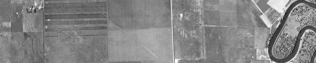

44 Diversion Channel Barr Footer: ArcGIS , :27 File: I:\Client\PolyMet_Mining\Work_Orders\Wetlands\Maps\Reports\Wetland_Mitigation_Plans\Aitkin\Figure Aerial Photo.mxd User: arm th Ave Mississippi River Aitkin Mitigation Site I ,600 Feet DRAFT Figure AERIAL PHOTO NorthMet Project Poly Met Mining Inc. Hoyt Lakes, MN

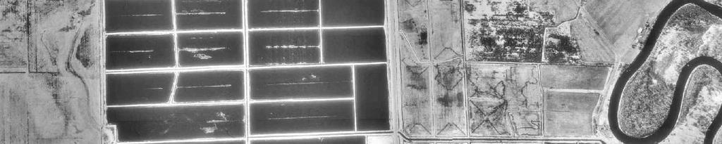
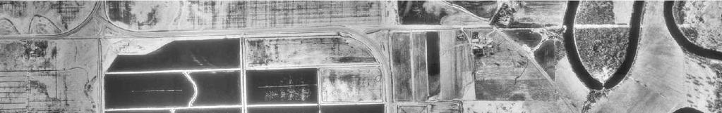
45 Diversion Channel Barr Footer: ArcGIS , :27 File: I:\Client\PolyMet_Mining\Work_Orders\Wetlands\Maps\Reports\Wetland_Mitigation_Plans\Aitkin\Figure Aerial Photo.mxd User: arm th Ave Mississippi River Aitkin Mitigation Site I ,600 Feet DRAFT Figure AERIAL PHOTO NorthMet Project Poly Met Mining Inc. Hoyt Lakes, MN
46 Appendices
47 Appendix A Permanent Conservation Easement Example
48 (Above Space is Reserved for Recording Information) PERPETUAL CONSERVATION EASEMENT FOR WETLAND BANK Grantor: Location: within Section 5, Township 39 North, Range 22 West, County of Pine This Perpetual Conservation Easement for Wetland Replacement ( Easement ) is made on (date) by the undersigned, hereinafter referred to collectively as the Grantor : RECITALS A. This Easement is made pursuant to and in furtherance of the Wetland Conservation Act of 1991, as amended, Minn. Stat. 103G.222, et. seq. ( WCA ) and the rules implementing WCA, Minn. R. ch ( WCA Rules ). B. This Easement pertains to all or part of the real property in Pine County, Minnesota, which is legally described on Exhibit A attached hereto and made a part hereof ( Real Property ). C. The Real Property is the subject of a wetland bank plan pursuant to Minn. R D. The Grantors include all of the following (1) all the fee owners of the Real Property and (2) the applicants under the bank plan if different from the fee owners. The term Grantor includes all of the Grantors if there is more than one. The Grantors are jointly and severally responsible for complying with the terms of this instrument. This Easement and the duties and restrictions contained in it shall also run with the land. E. WCA is administered by the State of Minnesota through its Board of Water and Soil Resources ( State ). BWSR Form: wca-bank-06 (easement).doc Revised 2/12/03 Page 1 of 6
49 F. The local government unit ( LGU ) charged under WCA with approval of the subject wetland replacement plan ( replacement plan ) is the Minnesota Department of Natural Resources Division of Lands and Minerals. The subject wetland mitigation plan includes all fully executed forms provided by the State, all supporting maps, engineering plans, drawings, monitoring plan, vegetation establishment plan and management plan and facilities maintenance plan. A complete copy of the replacement plan is on file at the LGU. The address of the LGU is 1525 Third Avenue East, Hibbing, MN The State is responsible for the acceptance of this Easement. G. The replacement plan requires the restoration or creation of a wetland on the portion of the Real Property designated in Exhibit B attached hereto and made a part hereof ( Replacement Area ). The replacement plan may also require the establishment of upland buffer within the Replacement Area. This Easement pertains to both wetlands and specified uplands within the Replacement Area. H. The Replacement Area is subject to the WCA, WCA Rules and all other provisions of law that apply to wetlands, except that the exemptions in Minn. Stat. 103G.2241 and Minn. R do not apply to the Replacement Area, pursuant to Minn. Stat. 103G.222, subd. 1(h) and Minn. R I. All references in this Easement to Minnesota Statutes and to Minnesota Rules are to the statutes and rules currently in effect and as amended or renumbered in the future. J. The purposes of this Easement are to maintain and improve the ecological values of the Replacement Area through the means identified in the replacement plan and to preserve the Replacement Area in a natural condition in perpetuity. IN ADDITION, THE GRANTORS, FOR THEMSELVES, THEIR HEIRS, SUCCESSORSAND ASSIGNS COVENANT THAT THEY: 1. Shall establish and maintain wetlands and upland buffers within the Replacement Area as specified in the replacement plan approved by the LGU and on file at the offices of the LGU. The wetland and any specified upland buffer area shall be the size and type specified in the replacement plan. Grantor shall not make any use of the Replacement Area that would adversely affect any of the functions or values of the area. Those functions and values are identified in Minn. R , subp. 10, or specified in the approved replacement plan. 2. Shall pay the costs of establishment, maintenance, repairs and reconstruction of the wetlands and specified upland buffers within the Replacement Area, which the LGU or the State may deem necessary to comply with the specifications for the Replacement Area in the approved replacement plan. The Grantor s obligations under this paragraph include the payment of any lawful taxes or assessments on the Real Property. 3. Shall establish and maintain visible monuments such as signs, numbered fence posts or survey posts at prominent locations along the boundary of the Replacement Area in accordance with the approved replacement plan. If numbered fence posts are used, Grantor s Replacement Plan must contain a survey or scaled drawing of the property that corresponds to the fence post numbering. Posts BWSR Form: wca-bank-06 (easement).doc Revised 2/12/03 Page 2 of 6
50 must be at least 4 feet high and notably visible on the landscape. If signs are used, such signs must be have a surface area of at least one quarter (1/4) square feet, mounted on a fence post at least 4 feet above ground, and minimally contain the words Boundary of Wetland Replacement Area - Subject to Perpetual Conservation Easement Restrictions Contact MN Board of Water and Soil Resources or Local Soil and Water Conservation District for Further Information. Said monuments must be made of non-degradable material and shall be at least four feet in height. 4. Grants to the LGU, the State, and the agents and employees of the LGU and the State, reasonable access to the Replacement Area for inspection, monitoring and enforcement purposes. The LGU, the State, and the agents and employees of the State are hereby granted a perpetual ingress and egress easement ("Access Easement") for access to and from the Replacement Area. The Access Easement shall be over and across the area ("Access Area") that is specified on Exhibit A attached hereto and made a part hereof or, if not specified on Exhibit A, the most reasonably direct and convenient route between the Replacement Area and a public road. If all or any part of the Access Area is owned by a person or entity other than Grantor, then the owner has joined in this Easement for purposes of granting the Access Easement by signing below. The signed written consent and subordination of all other holders of interests in the Access Area has been or will be obtained by Grantor and recorded in the same manner as specified in paragraph 5 below. This Easement grants no access to or entry to the Real Property, the Replacement Area, or the Access Area to the general public. 5. Represents that Grantor is (a) the fee owner of the Real Property and (b) the applicant under the replacement plan, if different from the fee owner. Grantor represents that all other parties who may have an interest in the Real Property (e.g., mortgagees, contract for deed vendees, holders of easements, etc.) have consented and subordinated their interests to this Easement by signing below. If it is determined at any time that there is any other party who may have an interest in the Real Property that is prior to this Easement, then Grantor shall immediately obtain and record a consent and subordination agreement signed by such other party. Acceptance of this Easement does not release Grantor from the obligation to obtain and record a consent and subordination agreement signed by any party who may have an interest in the Real Property that is prior to this Easement, even if such interest was of record at the time of acceptance. 6. Will record this easement at Grantor s expense in the real property records of the county where the Real Property is located. Said recording shall take place within 30 days of the State s acceptance of this Easement. The Grantor shall provide the original copy of the recorded easement to the State prior to making any credits from this replacement area available for use. 7. Acknowledge that this Easement shall be unlimited in duration, without being rerecorded. This Easement shall be deemed to be a perpetual conservation easement pursuant to Minn. Stat. ch. 84C. 8. Acknowledge that, unless expressly authorized in writing by the LGU in the approved replacement plan, Grantor: (a) Shall not produce agricultural crops on the Replacement Area, except that this provision does not restrict the harvest of the seeds of native vegetation if only the seed-head is BWSR Form: wca-bank-06 (easement).doc Revised 2/12/03 Page 3 of 6
51 (b) (c) (d) (e) (f) (g) (h) (i) removed in the process of harvest and does not involve the use of vehicular, motorized equipment; Shall not cut hay, mow vegetation or cut timber on the Replacement Area except as allowed or prescribed in the Replacement Plan; Shall not make any vegetative alterations on the Replacement Area that do not enhance or would degrade the ecological functions and values of the Replacement Area. Vegetative alterations shall be limited to those listed in the approved replacement plan; Shall not graze livestock on the Replacement Area; Shall not place any materials, substances or other objects, nor erect or construct any type of structure, temporary or permanent, on the Replacement Area. Shall not allow vehicular traffic on the Replacement Area except for the purpose of implementing construction or maintenance activities specifically authorized in the replacement plan. Shall not alter the topography of the Replacement Area by any means including plowing, dredging, filling, mining or drilling except for the purpose of implementing construction or maintenance activities specifically authorized in the replacement plan. Shall not modify the hydrology of the Replacement Area in any way or by any means including pumping, draining, ditching, diking, impounding or diverting surface or ground water into or out of the Replacement Area except for the purpose of implementing construction or maintenance activities specifically authorized in the replacement plan. Shall regularly inspect and maintain structures specified in the Replacement Plan in good working condition to sustain the goals in the approved Replacement Plan. 9. Acknowledge that the Grantor is responsible, at Grantor s cost, for weed control by complying with noxious weed control laws and emergency control of pests necessary to protect the public health on the Replacement Area. 10. Acknowledge that this Easement may be modified only by the joint written approval of the LGU and the State. If the Replacement Area has been used to mitigate wetland losses under the Federal Water Pollution Control Act, the U.S. Army Corps of Engineers (or successor agency) must also agree to the modification in writing. 11. Acknowledge that this Easement may be enforced, at law or in equity, by the LGU or the State. The LGU and the State shall be entitled to recover an award of reasonable attorney s fees from Grantor in any action to enforce this Easement. The right to enforce the terms of this Easement is not waived or forfeited by any forbearance or failure to act on the part of the State or LGU. If the subject Replacement Area is to be used partially or wholly to fulfill permit requirements under the Federal Water Pollution Control Act or a federal farm program, then the provisions of this Easement BWSR Form: wca-bank-06 (easement).doc Revised 2/12/03 Page 4 of 6
52 that run to the State or the LGU may also be enforced by the United States of America in a court of competent jurisdiction. 12. Acknowledge that this Easement is not valid until the Easement has been accepted by the State, the Grantor has recorded this Easement and the State has received evidence of such recording. BWSR Form: wca-bank-06 (easement).doc Revised 2/12/03 Page 5 of 6
53 SIGNATURE OF GRANTOR SIGNATURE OF FEE OWNER(S): STATE OF MINNESOTA ) ) ss. COUNTY OF ) This instrument was acknowledged before me this day of, by (name(s) with marital status). T Notarial Stamp or Seal Notary Public SIGNATURE OF BANK APPLICANT (S), IF DIFFERENT FROM FEE OWNER: STATE OF MINNESOTA ) ) ss. COUNTY OF ) This instrument was acknowledged before me this day of, by (name(s) with marital status). T Notarial Stamp or Seal Notary Public BWSR Form: wca-bank-06 (easement).doc Revised 2/12/03 Page 6 of 6
54 ACCEPTANCE The State accepts the foregoing Easement. MINNESOTA BOARD OF WATER AND SOIL RESOURCES: By: Its: STATE OF MINNESOTA ) ) ss. COUNTY OF ) This instrument was acknowledged before me this day of, by (name of person) as (title) of the Board of Water and Soil Resources. T Notarial Stamp or Seal Notary Public This instrument was drafted by the Board of Water and Soil Resources One West Water Street, St. Paul, MN If there are additional holders of interest the subject real property CHECK HERE and attach their Consent and Subordination agreement [BWSR Form Number: wca-bank-03 (consent).doc]. BWSR Form: wca-bank-06 (easement).doc Revised 2/12/03 Page 7 of 6
55 EXHIBIT A Legal Description of Real Property
56 EXHIBIT B Map or Survey of Bank Area
57 Appendix B Soil and Water Transect Data

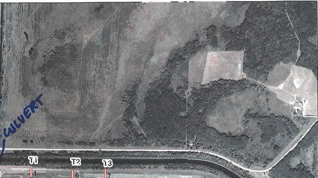


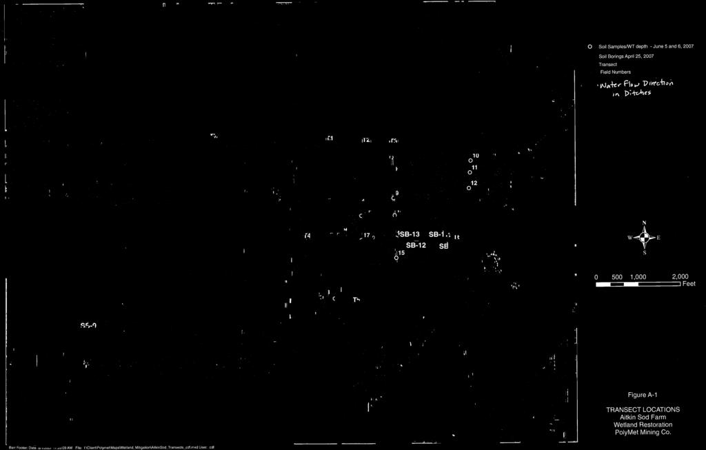
58 Figure B-1
59 Figure B-2


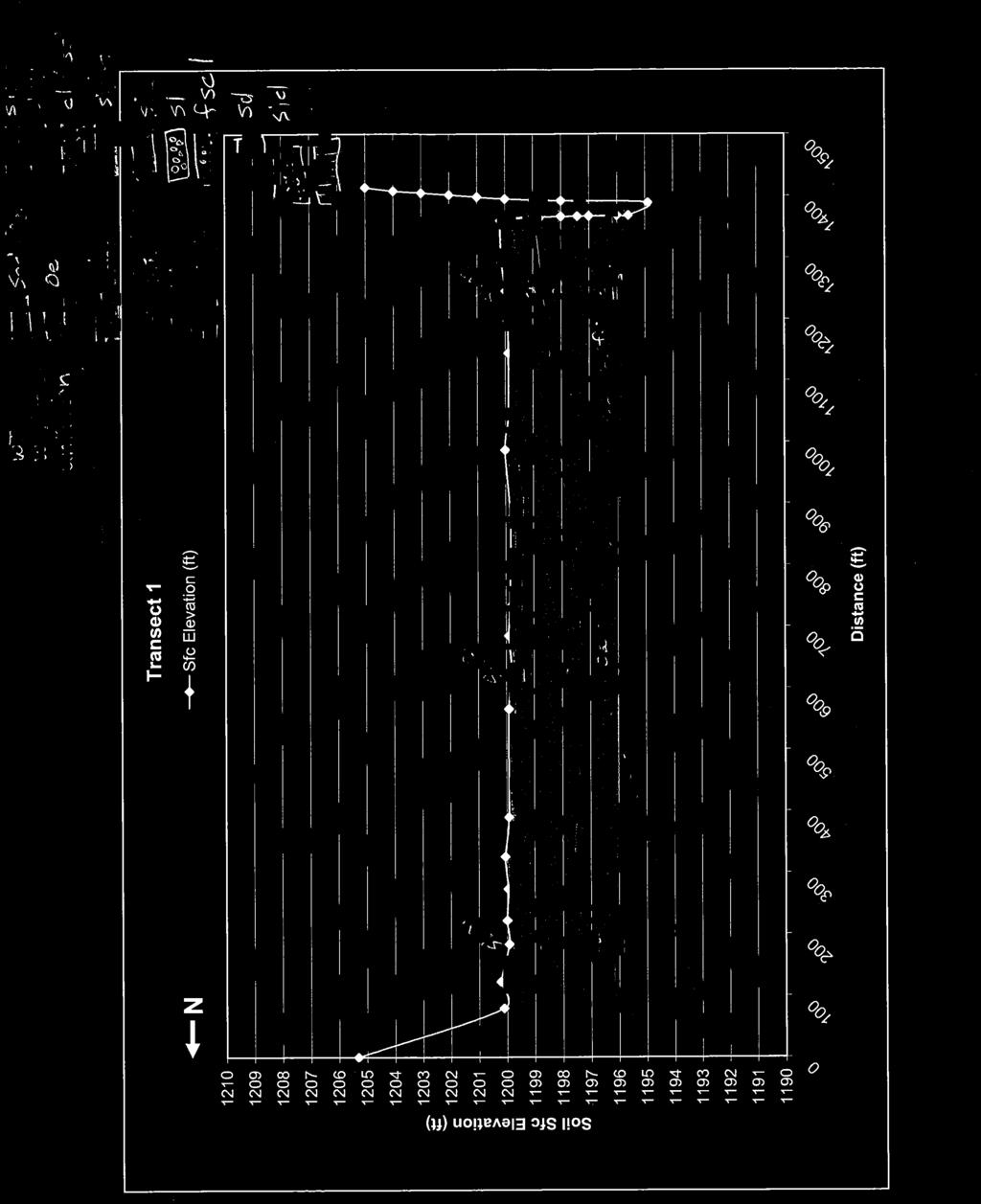
60 Figure B-3

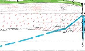

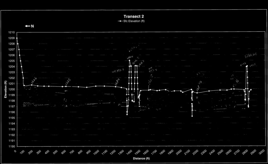
61 Figure B-4


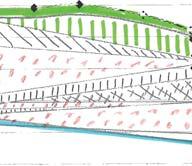

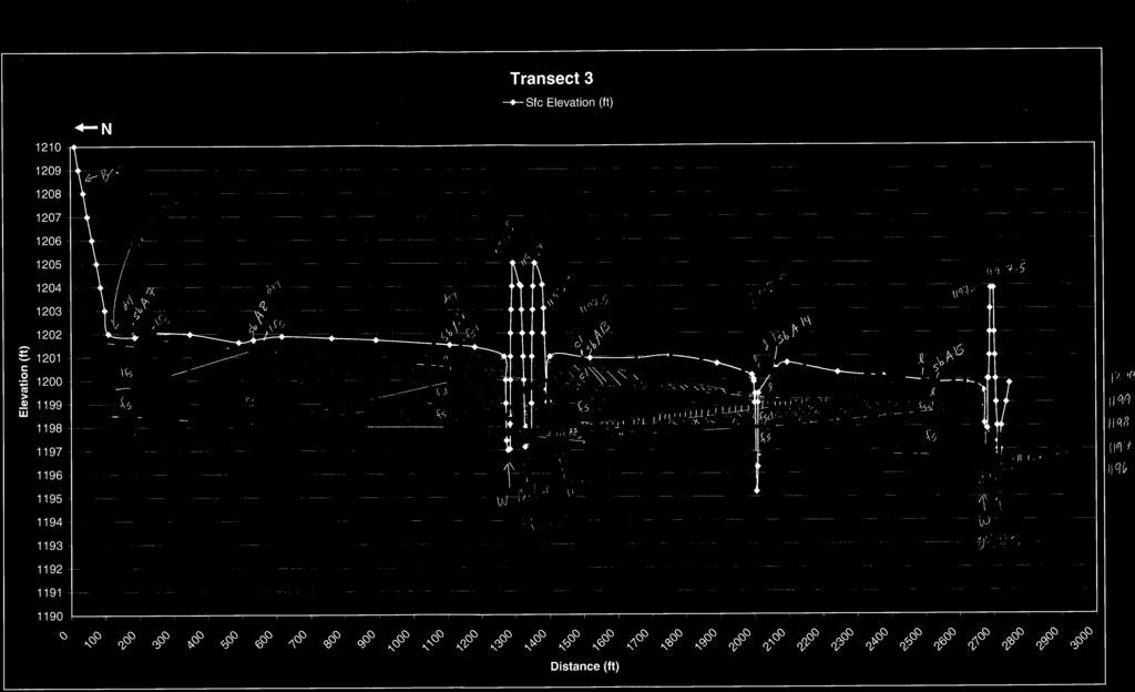
62 Figure B-5


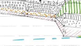

63 Figure B-6

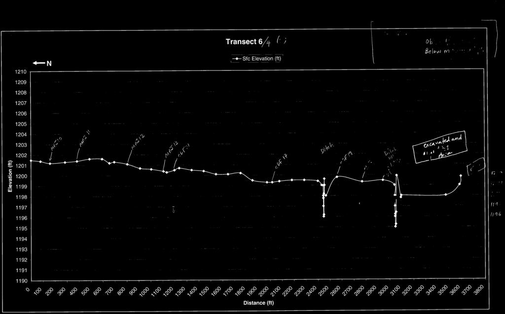
64 Figure B-7
65 Figure B-8

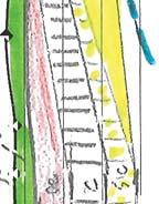
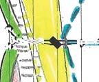


66 Figure B-9
Hinckley Wetland Mitigation Site
 Hinckley Wetland Mitigation Site Wetland Mitigation Plan Poly Met Mining Inc. May 2014 Hinckley Wetland Mitigation Site Wetland Mitigation Plan Poly Met Mining Inc. May 2014 Hinckley Wetland Mitigation
SECTION 10: WETLANDS PROTECTION
 SECTION 10: WETLANDS PROTECTION 10-1 INTENT AND PURPOSE A. Intent 1. The City finds that wetlands serve a variety of beneficial functions. Wetlands maintain water quality, reduce flooding and erosion,
Performance Standards for Target Hydrology
 Performance Standards for Target Hydrology Steve Eggers Senior Ecologist Regulatory Branch St. Paul District December 10, 2015 US Army Corps of Engineers Introduction Target Hydrology: the hydrology necessary
Update on the National Wetland Plant List
 Update on the National Wetland Plant List Steve Eggers Senior Ecologist July 2013 Steve D. Eggers US Army Corps of Engineers Steve D. Eggers Steve D. Eggers http://wetland_plants.usace.army.mil 7/22/2013
Wetland Mitigation Crediting & Performance
 Wetland Mitigation Crediting & Performance Subhead for title slide BWSR Academy 2014 Overview Quick Review of Crediting Banking vs Impact Approvals & the Private Market Basic Requirements & Considerations
Appendix E Preliminary Jurisdictional Wetland Delineation Report, JYL 2008
 Appendix E Preliminary Jurisdictional Wetland Delineation Report, JYL 2008 PRELIMINARY JURISDICTIONAL WETLAND DELINEATION REPORT A portion of USS 3819 and 2664: Horton Lot and Statter Harbor Juneau, Alaska
BLOOMINGDALE PARK DISTRICT SPRINGFIELD PARK WETLAND REPORT AND STEWARDSHIP PLAN
 BLOOMINGDALE PARK DISTRICT SPRINGFIELD PARK WETLAND 2014-2015 REPORT AND STEWARDSHIP PLAN Pizzo and Associates, LTD Prepared by: Forrest Rackmyer Photos are examples of species observed at Springfield
Sage Lake Cedar Swamp Ecological Reference Area (ERA)
") Sage Lake Cedar Swamp Ecological Reference Area (ERA) Administrative Information: Sage Lake Cedar Swamp Atlanta Management Unit Compartment 12, stands 26 & 188 (Avery Hills Management Area) Montmorency
Sage Lake Cedar Swamp Ecological Reference Area (ERA) Administrative Information: Sage Lake Cedar Swamp Atlanta Management Unit Compartment 12, stands 26 & 188 (Avery Hills Management Area) Montmorency
Public Notice ISSUED: 17 April 2018 EXPIRES: 17 May 2018
 SPONSOR: Kevin Root Public Notice ISSUED: 17 April 2018 EXPIRES: 17 May 2018 REFER TO: MVP-2017-00698-BBY SECTION: 404 - Clean Water Act 1. WETLAND COMPENSATORY MITIGATION BANK PROPOSAL 2. SPECIFIC INFORMATION
Public Notice ISSUED: 26 December 2017 EXPIRES: 26 January 2018
 SPONSOR: Carex Group, LLC Public Notice ISSUED: 26 December 2017 EXPIRES: 26 January 2018 REFER TO: MVP-2015-01348-EJI SECTION:404 - Clean Water Act 1 WETLAND COMPENSATORY MITIGATION BANK PROPOSAL 2 SPECIFIC
Public Notice ISSUED: October 16, 2017 EXPIRES: November 15, 2017
 SPONSOR: REFER TO: Wisconsin Department of Natural Resources (WDNR): Wisconsin Wetland Conservation Trust In-Lieu Fee (ILF) program MVP-2013-00984-RMG Public Notice ISSUED: October 16, 2017 EXPIRES: November
Wetland Regulatory Aspects of Plant Community Mapping
 Wetland Regulatory Aspects of Plant Community Mapping Major Topics: Delineation and Classification Wetland Implications (in-kind) Monitoring of Wetland Sites Delineating Plant Community Types t new concept
PROSPECTUS. Proposed Beech River Canal Wetland and Stream Mitigation Bank
 PROSPECTUS Proposed Beech River Canal Wetland and Stream Mitigation Bank INTRODUCTION This prospectus provides an overview of Beech River Farms, LLC s (BRF) proposed Beech River Canal Wetland and Stream
Recommended Wetland Management Standards According to Management Class
 Recommended Wetland Management Standards According to Management Class Measure Management Strategy Management Class Preserve Manage 1 Manage 2 Manage 3 Maintain wetland and existing functions, values and
Wetland Delineation. Richard L. Darden, Ph.D. U.S. Army Corps of Engineers Charleston District October 3, 2012 BUILDING STRONG
 Wetland Delineation Richard L. Darden, Ph.D. U.S. Army Corps of Engineers Charleston District October 3, 2012 Why Delineate Wetlands? To define the limits of federal jurisdiction, in accordance with current
SW-74 SERENOVA PRESERVE SITES 2, 3, 4, 8 MITIGATION PLAN
 SW-74 SERENOVA PRESERVE SITES 2, 3, 4, 8 MITIGATION PLAN BACKGROUND INFORMATION Project SWIM? Aquatic Control? Exotic Control? Mitigation Bank? Type No No No No Mitigation Restoration and enhancement Type
NorthMet Project. Wetland Management Plan. Version 7
 Version 7 Issue Date: January 28, 2015 Version: 7 Page i Table of Contents Acronyms, Abbreviations and Units... 3 1.0 Introduction... 4 1.1 Objective... 4 1.2 Outline... 4 2.0 Wetland Mitigation Design...
Public Notice ISSUED: 11 February 2019 EXPIRES: 13 March 2019
 SPONSOR: Minnesota Board of Water and Soil Resources Public Notice ISSUED: 11 February 2019 EXPIRES: 13 March 2019 REFER TO: MVP-2019-0122-JTB SECTION: 404 - Clean Water Act 1. WETLAND COMPENSATORY MITIGATION
SR 520 Medina to SR 202 Eastside Transit and HOV (Yarrow Creek Wetland) Mitigation Site USACE IP NWS
 Mitigation Site USACE IP NWS") SR 520 Medina to SR 202 Eastside Transit and HOV (Yarrow Creek Wetland) Mitigation Site USACE IP NWS-2009-562 Northwest Region 2018 MONITORING REPORT Wetlands Program Issued March 2019 Environmental Services
SR 520 Medina to SR 202 Eastside Transit and HOV (Yarrow Creek Wetland) Mitigation Site USACE IP NWS-2009-562 Northwest Region 2018 MONITORING REPORT Wetlands Program Issued March 2019 Environmental Services
CHAPTER 7 PHYSICAL INVENTORY OF THE CITY
 CHAPTER 7 PHYSICAL INVENTORY OF THE CITY Chapter 7: Physical Inventory of the City 39 This page intentionally left blank. Chapter 7: Physical Inventory of the City 40 SECTION 1 PHYSICAL SETTING While communities
PERFORMANCE STANDARDS AND MONITORING PROTOCOL FOR TIDAL WETLAND MITIGATION BANKS. October 28, 2016
 PERFORMANCE STANDARDS AND MONITORING PROTOCOL FOR TIDAL WETLAND MITIGATION BANKS October 28, 2016 A. Tidal wetland mitigation banks shall conform to the following performance standards by the end of the
ABBREVIATED NOTICE OF RESOURCE AREA DELINEATION YANKEE NUCLEAR POWER STATION ROWE, MASSACHUSETTS MARCH 2004 PREPARED FOR
 ABBREVIATED NOTICE OF RESOURCE AREA DELINEATION YANKEE NUCLEAR POWER STATION ROWE, MASSACHUSETTS MARCH 2004 PREPARED FOR YANKEE ATOMIC ELECTRIC COMPANY 49 YANKEE ROAD ROWE, MASSACHUSETTS 01367 PREPARED
The Crandon Mine Experience
 Determining Indirect Impacts to Wetland Plant Communities resulting from Mine-induced changes to Groundwater Hydrology The Crandon Mine Experience Jim Arndt, Ph.D., Westwood Professional Services John
Snitz Creek Park Wetland Mitigation Bank Prospectus. Pennsylvania Department of Transportation Engineering District 8-0
 Snitz Creek Park Wetland Mitigation Bank Prospectus Pennsylvania Department of Transportation Engineering District 8-0 February 2010 In accordance with 33 CFR 332.8(d)(2), The Pennsylvania Department of
What is a Wetland? Common Wetland Names. Wetlands: Ecotones between Upland and Aquatic Systems. Matthew J. Gray University of Tennessee.
 What is a Wetland? Matthew J. Gray University of Tennessee Common Wetland Names Backwater swamps Peatland Estuary Vernal Pools Marsh Playa Fen Bog Bayou Spring Seep Humedales Wetlands: Ecotones between
Appendix C-3. Wetlands and Other Surface Waters Report
 Appendix C-3 Wetlands and Other Surface Waters Report WETLANDS AND OTHER SURFACE WATERS REPORT Hatchet Ridge Wind Energy Project Shasta County, California Prepared for: Hatchet Ridge Wind, LLC Portland,
Minnetonka Code of Ordinances
 19. Tree Protection. a) Purpose. The goal of this subdivision is to preserve as much as practical Minnetonka's highly valued tree natural resources, ecosystems and viewsheds, while allowing reasonable
WETLAND DELINEATION REPORT
 WETLAND DELINEATION REPORT WHITMORE LAKE LOT WASHTENAW COUNTY, MICHIGAN JULY 2015 PREPARED FOR: WASHTENAW COUNTY PARKS AND RECREATION 2230 SOUTH PLATT ROAD ANN ARBOR, MICHIGAN 48104 PREPARED BY: THE MANNIK
INDIANA DEPARTMENT OF ENVIRONMENTAL MANAGEMENT We Protect Hoosiers and Our Environment. Mitchell E. Daniels Jr.
 INDIANA DEPARTMENT OF ENVIRONMENTAL MANAGEMENT We Protect Hoosiers and Our Environment. Mitchell E. Daniels Jr. 100 North Senate Avenue Governor Indianapolis, Indiana 46204 (317) 232-8603 Thomas W. Easterly
THE NEW WETLAND RULES How do they affect you? City Engineers Conference January 27, 2010
 THE NEW WETLAND RULES How do they affect you? City Engineers Conference January 27, 2010 Introduction Beth Kunkel, PWS Certified Professional Wetland Scientist Certified Wetland Delineator 22 years working
2015 Reinvest in Minnesota (RIM) Reserve Wetlands Program
 Reserve Wetlands Program") 2015 Reinvest in Minnesota (RIM) Reserve Wetlands Program Site Evaluation Form Instructions Document 12/31/14 This instructions document is to be used for guidance in completing the Site Evaluation Form
2015 Reinvest in Minnesota (RIM) Reserve Wetlands Program Site Evaluation Form Instructions Document 12/31/14 This instructions document is to be used for guidance in completing the Site Evaluation Form
Wetland Impact Assessment & Two Part Finding Form
 Office of Environmental Stewardship 395 John Ireland Blvd. St. Paul, MN 5555 February 208 Wetland Impact Assessment & Two Part Finding Form ** Red text provides descriptive guidance and should be replaced/removed
Public Notice ISSUED: EXPIRES:
 SPONSOR: City of Superior Public Notice ISSUED: EXPIRES: REFER TO: 2015-04234-WMS SECTION:404 - Clean Water Act 1. WETLAND COMPENSATORY MITIGATION BANK PROPOSAL 2. SPECIFIC INFORMATION. SPONSOR S ADDRESS:
Appendix D: MULTI-AGENCY COMPENSATORY MITIGATION PLAN CHECKLIST 1
 Appendix D: MULTI-AGENCY COMPENSATORY MITIGATION PLAN CHECKLIST 1 Mitigation Goals and Objectives o Describe functions lost at impact site o Describe functions to be gained at mitigation site o Describe
SR nd Street SE to 112th Street SE (527 Widening) Mitigation Site WIN # A52720B USACE NWP (14)
 Mitigation Site WIN # A52720B USACE NWP (14)") SR 527 132nd Street SE to 112th Street SE (527 Widening) Mitigation Site WIN # A52720B USACE NWP (14) 2002-00046 Northwest Region 2016 MONITORING REPORT Wetlands Program Issued March 2017 Environmental
SR 527 132nd Street SE to 112th Street SE (527 Widening) Mitigation Site WIN # A52720B USACE NWP (14) 2002-00046 Northwest Region 2016 MONITORING REPORT Wetlands Program Issued March 2017 Environmental
DRAFT UPDATE TO THE 2002 INTERAGENCY GUIDELINES FOR WETLAND COMPENSATORY MITIGATION IN WISCONSIN (GUIDELINES)
") Public Notice ISSUED: 13-February-2013 EXPIRES: 15-March-2013 DRAFT UPDATE TO THE 2002 INTERAGENCY GUIDELINES FOR WETLAND COMPENSATORY MITIGATION IN WISCONSIN (GUIDELINES) I. PURPOSE OF THIS PUBLIC NOTICE.
Public Notice ISSUED: 13-February-2013 EXPIRES: 15-March-2013 DRAFT UPDATE TO THE 2002 INTERAGENCY GUIDELINES FOR WETLAND COMPENSATORY MITIGATION IN WISCONSIN (GUIDELINES) I. PURPOSE OF THIS PUBLIC NOTICE.
PERFORMANCE STANDARDS AND MONITORING PROTOCOL FOR NONTIDAL WETLAND MITIGATION BANKS. October 28, 2016
 PERFORMANCE STANDARDS AND MONITORING PROTOCOL FOR NONTIDAL WETLAND MITIGATION BANKS October 28, 2016 A. Nontidal wetland mitigation banks shall conform to the following performance standards by the end
Review of Natural Environment Existing Conditions, Johnston Road Study Area
 Brunton Consulting Services 216 Lincoln Heights Road, Ottawa, Ontario K2B 8A8 Phone: (613) 829-7307 Fax: (613) 829-4688 e-mail: bruntonconsulting@rogers.com January 13, 2011 Review of Natural Environment
Wetland Functions in the Watershed: Part 1 Watershed Elements. USDA NRCS Module Name 1
 Wetland Functions in the Watershed: Part 1 Watershed Elements USDA NRCS Module Name 1 Objectives Define Landscape Elements in the Watershed Describe Hydrologic Connections Between Elements Introduce Soil
7.6 Wetlands, Riparian and Littoral Habitats
 7.6 Wetlands, Riparian and Littoral Habitats 7.6.1 Overview Yuba County Water Agency This section discusses wetland, riparian and littoral habitats in the vicinity 1 of Yuba County Water Agency s (YCWA
Compensatory Mitigation Plan Requirements For Permittee Responsible Mitigation Projects St. Louis District, Corps of Engineers May 2010
 Compensatory Mitigation Plan Requirements For Permittee Responsible Mitigation Projects St. Louis District, Corps of Engineers May 2010 The U.S. Army Corps of Engineers (Corps) and U.S. Environmental Protection
WETLANDS AND OPEN WATERS Compensatory Mitigation Definitions of Factors
 Adverse effects as used in this section of the SOP means any adverse ecological effect on wetlands or areas of open water. Those effects, or impacts, include filling, excavating, flooding, draining, clearing,
M E M O R A N D U M Clallam County Public Works Department
 M E M O R A N D U M Clallam County Public Works Department TO: TO: Craig Jacobs, Public Works Director Joel Winborn, Division Manager FROM: Dave Lasorsa, Environmental Coordinator SUBJ: Wetland Assessment
MANAGED FOREST LANDS STEWARDSHIP FORESTRY PLAN
 Page 1 of 19 MANAGED FOREST LANDS STEWARDSHIP FORESTRY PLAN Landowner(s) as Shown on Deed: Name and Address of Contact Person: Entry Period: 25 years Starting January 1, 2014 Ending December 31, 2038 Municipality(s):
Poly Met Mining, Inc. Antidegradation Review - Preliminary Determination for 401 Certification
 Poly Met Mining, Inc. Antidegradation Review - Preliminary Determination for 401 Certification Summary Poly Met Mining, Inc. (PolyMet) submitted an application for a Clean Water Act Section 401 Water Quality
Public Notice ISSUED: May 21, 2013 EXPIRES: June 20, 2013
 SPONSOR: REFER TO: Wisconsin Dept. of Transportation Public Notice ISSUED: May 21, 2013 EXPIRES: June 20, 2013 SECTION:404 - Clean Water Act 1. WETLAND COMPENSATORY MITIGATION BANK PROPOSAL 2. SPECIFIC
I-5/Mellen Street to Blakeslee Junction (Horseshoe Lake) Mitigation Site USACE IP NWS
 Mitigation Site USACE IP NWS") I-5/Mellen Street to Blakeslee Junction (Horseshoe Lake) Mitigation Site USACE IP NWS-2009-1211 Southwest Region 2018 MONITORING REPORT Wetlands Program Issued March 2019 Environmental Services Office
I-5/Mellen Street to Blakeslee Junction (Horseshoe Lake) Mitigation Site USACE IP NWS-2009-1211 Southwest Region 2018 MONITORING REPORT Wetlands Program Issued March 2019 Environmental Services Office
A GUIDE TO THE WETLAND, DEEPWATER HABITATS, AND RIPARIAN CLASSIFICATIONS USED IN WETLAND AND RIPARIAN MAPPING IN MONTANA
 A GUIDE TO THE WETLAND, DEEPWATER HABITATS, AND RIPARIAN CLASSIFICATIONS USED IN WETLAND AND RIPARIAN MAPPING IN MONTANA Purpose: The Montana Natural Heritage Program s Wetland and Riparian Mapping Center
1.1 INTRODUCTION 1.2 GOALS AND OBJECTIVES 1.3 SITE PROTECTION INSTRUMENT 1.4 BASELINE INFORMATION. SWG Mitigation Plan Sheet 1 of 9
 Sheet 1 of 9 P R E L I M I N A R Y M I T I G A T I O N P L A N 1.1 INTRODUCTION The proposed Permittee Responsible Mitigation (PRM) site for the Metro Park Square Project (SWG-2016-00264) consists of approximately
Public Notice ISSUED: March 17, 2016 EXPIRES: April 17, 2016
 SPONSOR: Stanley Antolick Public Notice ISSUED: March 17, 2016 EXPIRES: April 17, 2016 REFER TO: 2015-01201-LMG SECTION:404 - Clean Water Act 1. WETLAND COMPENSATORY MITIGATION BANK PROPOSAL 2. SPECIFIC
PERFORMANCE STANDARDS AND MONITORING PROTOCOL FOR NONTIDAL WETLAND MITIGATION BANKS. April 3, 2018
 PERFORMANCE STANDARDS AND MONITORING PROTOCOL FOR NONTIDAL WETLAND MITIGATION BANKS April 3, 2018 A. Nontidal wetland mitigation banks shall conform to the following performance standards by the end of
Information for File # ARC
 Information for File # 2015-02993-ARC Applicant Corps Contact St. Louis-Lake Counties Regional Rail Authority Andrew R. Chambers Address 600 South Lake Avenue, Suite 211, Duluth, MN 55802 E-Mail Andrew.R.Chambers@usace.army.mil
Phase II: Proposed (regulated) Impervious in disturbed area (ac) Long Lake Existing Impervious in disturbed area (ac)
 Impervious in disturbed area (ac) Long Lake Existing Impervious in disturbed area (ac)") Permit Application No.: 17-181 Rules: Erosion Control, Wetland Protection, and Waterbody Crossings & Structures Applicant: Hennepin County Received: 4/27/17 Project: CSAH 112 Phase II Complete: 9/5/17
Permit Application No.: 17-181 Rules: Erosion Control, Wetland Protection, and Waterbody Crossings & Structures Applicant: Hennepin County Received: 4/27/17 Project: CSAH 112 Phase II Complete: 9/5/17
DA Permit SAJ Attachment G - Compensatory Mitigation Plan Attachment A, Part 3 - Mitigation Categories
 DA Permit SAJ-1993-01395 Attachment G - Compensatory Mitigation Plan Attachment A, Part 3 - Mitigation Categories ST-IS-R24 South Pasture Extension No Mine Boundary Open Water USACE Reclamation Only USACE
Clara Unit Card. Alternative 2 Acres: 19 Treatment Acres: 6 Stand Age: 106 Primary ELT: 16. Primary Treatment: Single-Tree Selection
 Unit: 7-013-014 Total BA: 62 Forest Type: Quaking Aspen New Forest Type: Aspen/W.Spruce/Fir Primary Treatment: Single-Tree Selection Acres: 19 Treatment Acres: 6 Stand Age: 106 Primary ELT: 16 Treatment
Public Notice Corps of Engineers
 Public Notice US Army Corps of Engineers Memphis District REPLY TO ATTN: Roger Allan U.S. Army Corps of Engineers 167 North Main Street, Room B-202 Memphis, Tennessee 38103-1894 Telephone: (901) 544-3682
SECONDARY WETLAND IMPACTS ANALYSIS
 SECONDARY WETLAND IMPACTS ANALYSIS USACE File. SWG-2012-00153 During the development of the Grand Parkway (State Highway 99) Segments H and I-1 from United States Highway 59/Interstate Highway 69 N to
38. VEGETATION Introduction. Vegetation Cook Inlet Drainages
 38. VEGETATION 38.1 Introduction The vegetation study describes the predominant vegetation types found in the Cook Inlet drainages study area. This information also helps to support wetland and habitat
Wetlands. DuPage County Stormwater Ordinance Update- Wetlands and Buffers. Is a Stormwater Permit Required? 7/13/2012
 DuPage County Stormwater Ordinance Update- Wetlands and Buffers PRESENTED BY: MARY BETH FALSEY WETLAND SPECIALIST Wetlands Section 15-18.A.1.a: If a Stormwater Administrator has the expertise, he/she can
Chapter 13: Wildlife and Vegetation
 Chapter 13: Wildlife and Vegetation Introduction and Setting Nevada County contains an extremely wide range of plants, animals and habitat types. With topographic elevations ranging from 300 feet in the
WETLAND MITIGATION IN MINNESOTA: One Nonprofit's Perspective
 Northeastern WETLAND MITIGATION IN MINNESOTA: One Nonprofit's Perspective Jill Bathke, Natural Resource Scientist Minnesota Center For Environmental Advocacy Heart of our mission: a reverence for nature
Names: ESS 315. Lab #6, Floods and Runoff Part I Flood frequency
 Names: ESS 315 Lab #6, Floods and Runoff Part I Flood frequency A flood is any relatively high flow of water over land that is not normally under water. Floods occur at streams and rivers but can also
Target Hydrology and Performance Standards for Compensatory Mitigation Sites
 Target Hydrology and Performance Standards for Compensatory Mitigation Sites I. Executive Summary VERSION: 6.0 DATE: MARCH 20, 2019 This guidance document is an update and expansion of previous guidance
Nonmetallic Mining Reclamation & Operation Plan. Amendment No. 1 (Includes modifications for Wash Plant construction) DRAFT
 DRAFT") Nonmetallic Mining Reclamation & Operation Plan Amendment No. 1 (Includes modifications for Wash Plant construction) Mondovi Mine Town of Mondovi, Wisconsin Prepared for: Buffalo White Sand, LLC PO Box
Nonmetallic Mining Reclamation & Operation Plan Amendment No. 1 (Includes modifications for Wash Plant construction) Mondovi Mine Town of Mondovi, Wisconsin Prepared for: Buffalo White Sand, LLC PO Box
Saving Wetlands. Is saving Lives
 Saving Wetlands Is saving Lives What are Wetlands? areas between water and land What are Wetlands? contain hydric soil - saturated by water. soil lacks oxygen when saturated land that is seasonally wet.
Chapter 2: Conditions in the Spring Lake Watershed related to Stormwater Pollution
 Chapter 2: Conditions in the Spring Lake Watershed related to Stormwater Pollution To identify the primary causes and consequences of stormwater discharges to Spring Lake and its adjoining waterbodies,
Collaborative Opportunities to Restore Wetland Functions in an Urbanized Setting: Moses Creek Restoration Case Study
 Collaborative Opportunities to Restore Wetland Functions in an Urbanized Setting: Moses Creek Restoration Case Study Presented to: SER 2013 World Conference Madison, WI 2013 Award Winner Presented by:
39. WETLANDS Introduction. Wetlands and Waterbodies Cook Inlet Drainages
 39. WETLANDS 39.1 Introduction This chapter summarizes the wetlands and waterbodies study for the Cook Inlet drainages study area (Figure 39-1). The objectives of the study were to determine and map the
LAKE COUNTY HYDROLOGY DESIGN STANDARDS
 LAKE COUNTY HYDROLOGY DESIGN STANDARDS Lake County Department of Public Works Water Resources Division 255 N. Forbes Street Lakeport, CA 95453 (707)263-2341 Adopted June 22, 1999 These Standards provide
Background. Literature Review
 Ms. Joanna Helms Economic Development Director Town of Apex 73 Hunter Street P.O. Box 250 Apex, North Carolina 27502 October 23, 2015 Reference: Report of Wetland Determination Cash Perkins Site ECS Project
Chapter 10 Natural Environment
 Chapter 10 Natural Environment Existing Conditions The Natural Environment Element addresses the protection, conservation, preservation, and restoration of the natural resources the Bayview Ridge Subarea,
Cover it up! Using plants to control buckthorn
 Cover it up! Using plants to control buckthorn Mike Schuster, Peter Wragg, Peter Reich, Lee Frelich Minnesota Invasive Terrestrial Plants and Pests Center University of Minnesota Alex Roth Paul Bockenstedt
Public Notice ISSUED: June 29, 2017 EXPIRES: July 31, 2017
 SPONSOR: Gary Pestorious Public Notice ISSUED: June 29, 2017 EXPIRES: July 31, 2017 REFER TO: 2012-01634-DAS SECTION:404 - Clean Water Act 1. WETLAND COMPENSATORY MITIGATION BANK PROPOSAL: Pickerel Lake
How to avoid getting bogged down by the Nova Scotia Wetland Conservation Policy
 How to avoid getting bogged down by the Nova Scotia Wetland Conservation Policy for the Environmental Services Association of Nova Scotia By Krista Hilchey Wetland Specialist, Nova Scotia Environment To
Pine Oak Hemlock in the Northeast
 Pine Oak Hemlock in the Northeast Silvics, Dynamics, Climate Change, Restoration Tom Lee Department of Natural Resources and the Environment University of New Hampshire 1 Topics Where is pine oak hemlock
HOUSE BILL lr0052
 M HOUSE BILL lr00 By: Chair, Environment and Transportation Committee (By Request Departmental Environment) Introduced and read first time: February, 0 Assigned to: Environment and Transportation Committee
Deep River-Portage Burns Waterway Watershed 2015
 2.4 Soils Soil development is the product of the interaction of parent material, topography, climate, organisms and time. Understanding the types of soils that exist within a watershed and their characteristics
LESSON TEN: What Is an Ecological Site and What Causes Plant Community Change?
 LESSON TEN: What Is an Ecological Site and What Causes Plant Community Change? Ecological Sites Ecological sites are a distinctive kind of land that is different from all other kinds of land based on soil
Design Features of Constructed Wetlands for Nonpoint Source Treatment. September 1995
 Design Features of Constructed Wetlands for Nonpoint Source Treatment September 1995 Brochure written by William W. Jones, School of Public and Environmental Affairs, Indiana University, Bloomington, Indiana.
Plant, Wildlife and Wetland Assessment
 WSU Project Site Plant, Wildlife and Wetland Assessment approximately 38 acres of the site would be in retained natural area, including passive use portions of the park and smaller natural areas in other
CATEGORY a protection of the natural environment, its ecosystems and biodiversity.
 29. ENVIRONMENTAL DEVELOPMENT PERMIT AREA CATEGORY a protection of the natural environment, its ecosystems and biodiversity. The requirement to obtain an environmental development permit is cited in Section
FOREST MANAGEMENT PLAN For the GLADDEN MEMORIAL WOODLAND
 FOREST MANAGEMENT PLAN For the GLADDEN MEMORIAL WOODLAND Prepared by Don Carlson-Purdue University Forester DECEMBER 2003 1. Legal Description and Location The Purdue University Claude M. Gladden Memorial
Chapter 6: Land Use/Land Cover
 Chapter 6: Land Use/Land Cover The general historic land use pattern that emerged in Burt Township is similar to many other communities across the Upper Peninsula. Commercial fishing and lumbering were
TECHNICAL SUPPORT DOCUMENT # 1 COMPARATIVE EVALUATION OF ALTERNATIVE SITES APPENDIX TDS#1-G. Agriculture Component
 TECHNICAL SUPPORT DOCUMENT # 1 COMPARATIVE EVALUATION OF ALTERNATIVE SITES APPENDIX TDS#1-G Agriculture Component February 2013 February 2013 Agriculture Component Appendix TSD#1-G COMPARATIVE EVALUATION
Maine s Land Use Regulations and Erosion Control Techniques
 Maine s Land Use Regulations and Erosion Control Techniques Protecting Maine s Air, Land and Water Colin Clark 441-7419 colin.a.clark@maine.gov Tom Gilbert 441-8031 thomas.gilbert@maine.gov Jim Rodrigue
Red Pine Management Guide A handbook to red pine management in the North Central Region
 Red Pine Management Guide A handbook to red pine management in the North Central Region This guide is also available online at: http://ncrs.fs.fed.us/fmg/nfgm/rp A cooperative project of: North Central
Taking Action to Protect UW-Stout s Last Remaining Wetland
 Taking Action to Protect UW-Stout s Last Remaining Wetland Maxine Pettis Undergraduate Student, Applied Science Key words: Wetland delineation, wetland indicators, hydrophytic vegetation, hydric soils,
Restoring The North Shore Forest. Welcome!
 Restoring The North Shore Forest Welcome! A bit about this evening History and current condition of North Shore Vegetation Info on North Shore Forest Collaborative How you can help make a difference on
AMERICAN ELECTRIC POWER (SWEPCO)
") 2016 DAM & DIKE INSPECTION REPORT ASH PONDS GERS-16-163 WELSH POWER PLANT AMERICAN ELECTRIC POWER (SWEPCO) CASON, TEXAS NATIONAL INVENTORY NO. TX4357 PREPARED BY GEOTECHNICAL ENGINEERING AEP SERVICE CORPORATION
2016 DAM & DIKE INSPECTION REPORT ASH PONDS GERS-16-163 WELSH POWER PLANT AMERICAN ELECTRIC POWER (SWEPCO) CASON, TEXAS NATIONAL INVENTORY NO. TX4357 PREPARED BY GEOTECHNICAL ENGINEERING AEP SERVICE CORPORATION
Public Notice. MVK Ms. Tarmiko Graham (601) July 25, 2018 August 23, 2018
 July 25, 2018 August 23, 2018") US Army Corps of Engineers. Vicksburg District 4155 Clay Street Vicksburg, MS 39183-3435 www.mvk.usace.army.mil Public Notice APPLICATION NO.: EVALUATOR: PHONE NO.: E-MAIL: DATE: EXPIRATION DATE: MVK-2018-336
US Army Corps of Engineers. Vicksburg District 4155 Clay Street Vicksburg, MS 39183-3435 www.mvk.usace.army.mil Public Notice APPLICATION NO.: EVALUATOR: PHONE NO.: E-MAIL: DATE: EXPIRATION DATE: MVK-2018-336
Wetland Identification/Delineation and Bog Turtle Habitat Screening Report for. S.R. 0097, Section 003 Two Taverns Bridge Replacement over Littles Run
 Wetland Identification/Delineation and Bog Turtle Habitat Screening Report for S.R. 0097, Section 003 Two Taverns Bridge Replacement over Littles Run June 2003 Prepared for: The Pennsylvania Department
NorthMet Project Baseline Wetland Type Evaluation
 NorthMet Project Baseline Wetland Type Evaluation Mine Site and Tailings Basin Areas Prepared for PolyMet Mining Inc. March 2010 NorthMet Project Baseline Wetland Type Evaluation Mine Site and Tailings
Cokato Lake (86-263) Wright County. Hydrologic Investigation
 Wright County. Hydrologic Investigation") Cokato Lake (86-263) Wright County Hydrologic Investigation April 14, 2005 Cokato Lake (86-263) Wright County Hydrologic Investigation April 14, 2005 Problem Statement In recent years, heavy rainfall has
Cokato Lake (86-263) Wright County Hydrologic Investigation April 14, 2005 Cokato Lake (86-263) Wright County Hydrologic Investigation April 14, 2005 Problem Statement In recent years, heavy rainfall has
Ecosystem Unit Analysis
 Ecosystem Unit Analysis Background information provided for the Ecosystem Unit Analysis is largely from the Field Guide to the Native Plant Communities of Minnesota: The Laurentian Mixed Forest Province
Wetland Mitigation Site Monitoring Report
 Wetland Mitigation Site Monitoring Report Agassiz Valley Water Resource Management Project 2014 (year three of five) Prepared for: The Middle-Snake-Tamarac Rivers Watershed District 453 McKinley Street,
Public Notice APPLICATION NO.: EVALUATOR: PHONE NO.: FAX NO.: DATE: EXPIRATION DATE:
 US Army Corps of Engineers. Vicksburg District 4155 Clay Street Vicksburg, MS 39183-3435 www.mvk.usace.army.mil Public Notice APPLICATION NO.: EVALUATOR: PHONE NO.: FAX NO.: E-MAIL: DATE: EXPIRATION DATE:
Minnesota Wetland Conservation Act Notice of Decision Permit to Mine
 Minnesota Wetland Conservation Act Notice of Decision Permit to Mine Approving Authority Department of Natural Resources (DNR) Division of Lands and Minerals Address 500 Lafayette Road N, Box 45 St. Paul,
Prepared by: Rummel, Klepper & Kahl
 WETLAND DELINEATION REPORT Kutztown Road (SR 1033) Resurfacing and Bridge Replacement Upper Hanover Township, Montgomery County, Pennsylvania Prepared for: PennDOT District 6-0 Prepared by: Rummel, Klepper
16.0 Water Quality Management Criteria for Developed Land
 October 2003, Revised February 2005 Criteria for Developed Land Page 1 16.1 Introduction 16.0 Water Quality Management Criteria for Developed Land Stormwater quality control is an integral part of any