Wetland Mitigation Site Monitoring Report
|
|
|
- Marcus Hood
- 6 years ago
- Views:
Transcription

1 Wetland Mitigation Site Monitoring Report Agassiz Valley Water Resource Management Project 2014 (year three of five) Prepared for: The Middle-Snake-Tamarac Rivers Watershed District 453 McKinley Street, PO Box 154 Warren, MN I hereby certify that this field investigation and report was prepared by me or under my direct supervision. Mark D. Aanenson CWD Certification No Date: 1/29/2015 Houston Engineering Inc st Avenue North Fargo, ND Ph. (701) HE Project No
2 Introduction This report documents the third year of monitoring of the wetland replacement site for the Agassiz Valley Water Resource Management Project (The Project) site located in Sections 12 and 13 of T154N R47W and Sections 7 and 18 of T154N R46W in Marshall and Polk County, Minnesota. The purpose of this annual report is to provide a record of the vegetative and hydrology parameters of the wetland mitigation area. This report identifies the field conditions of the wetland replacement site that were observed and measured by Houston Engineering staff. Well and staff gauge readings were taken by Middle-Snake-Tamarac River Watershed District staff. Description of the Site This multipurpose project covers approximately four sections of land in McCrea and Comstock Townships in Marshall County and Brislet and Helgeland Townships in Polk County (Attachment A). The structure straddles the line between Marshall and Polk Counties. The impoundment will stores floodwaters that flow into the Red River of the North by the way of the Snake River and Judicial Ditch No The site is about 62.4 channel miles above the Red River of the North. The city of Warren is six miles west and one mile north of the structure site. On Site Mitigation On-site mitigation was proposed in the north half of Section 7 of T154N R46W in Marshall County. The hydrology of the mitigation site was established by diverting runoff from the project inlet channel. A weir was constructed in the ditch and runoff is diverted during high flows into the mitigation site. Excess water exits the site to the west through two corrugated metal pipes (CMP, Attachment A). The drainage surrounding the mitigation site was also modified to bring runoff to the site. The site was proposed to be a 36.1 acre Circular 39 Type 1 and 3 wetland complex with seasonally flooded and shallow marsh plant communities. A seeding plan for the adjacent upland areas is shown in Table 1. The seed mix was a WRP seeding mix provided by the West Polk NRCS office, and was planted with a Truax drill or similar type. Table 1. Seed Mix for the Upland Areas Grasses Forbs Species Seed lbs./acre Species Seed oz./acre Big Bluestem 4 Prairie Blazing Star 2 Indiangrass 2 Maximillian Sunflower 2 Side Oats Grama 2 Wild Bergamot 2 Canada Wildrye 1 Yarrow 1 Switchgrass 0.5 Stiff Goldenrod 2 1
3 The mitigation site was constructed primarily in 2009 and seeded initially in In 2011 the site was evaluated and determined that a seeding catch was not adequate and a reseeding of the uplands was completed in Monitoring of the wetland consists the following: an inventory of the vegetative communities within the mitigation site, photographs of the site, and observations of the hydrologic conditions. At the end of the monitoring period, a wetland delineation will be conducted to measure and document the new wetland acres created. In 2014, two monitoring wells were placed at sites near the north end of the project area (Attachment B). Staff gauges were planned for each of the large ponds, but were not placed due to high water levels caused by heavy precipitation events. As an alternative, the staff gauge at the outlet of the mitigation site was monitored and considered representative of the water levels in the system pond. This outlet structure was closed for the season on November 14, 2014 when the pool was empty. Also in 2014, an additional vegetation monitoring site was added (Site 5, Appendix B). This upland site is intended to give more detailed and thorough monitoring data regarding the encroachment of weeds into the southern portion of the mitigation area, a potential problem as recognized in the 2013 Mitigation Report. Results General Physical Appearance The "as built" condition of the mitigation site appears to correspond with the locations and sizes shown on the project plans. The total size of the new wetland areas was calculated to be 51.0 acres (Attachment B). Approximately 40 acres are Circular 39 Type 3 wetlands and 11 acres are Circular 39 Type 1 wetlands. Upland buffer areas comprise approximately 25 acres of land surrounding the wetland areas. Photography of the site is included in Attachment C at the end of this report. Hydrology As in the previous monitoring report in 2013, the surface water depths were observed during the September site visit (Table 2). Hydrologic measurements were estimated through visual observation. The well monitoring data were collected between July 2 and October 31, 2014 (Table 3). By September 19, some of the wells began to dry, and by October 3 rd, most were dry to the bottom of the well. 2
4 Table 2. Hydrologic Conditions Observed During Vegetation Monitoring 9/29/14 Site Site 1 Site 2 Site 3 Site 4 Site 5 Estimated Average Water Depth In Wetland Area No surface water and not saturation observed None Uplands Average water depths north of the sample location = 0.5 to 1.0 feet Average water depths west of the sample location = Saturated to 0.5 feet None Uplands Table 3. Agassiz Valley Well Monitoring Well Measurements 2014, water elevation in feet at each measurement date. Staff Gauge* Well 1 Well 2 Well 3 Well 4 n/a Elev. at Natural Ground (ft.) Elev. at Natural Ground (ft.) Elev. at Natural Ground (ft.) Elev. at Natural Ground (ft.) Sample Date elev. Water elev. Water Distance below Surface elev. Water Distance below Surface elev. Water Distance below Surface elev. Water Distance below Surface 7/2/ /14/ /1/ /7/ /15/2014 no data /22/ /29/2014 no data /5/ /12/ /19/ /26/ /3/ /10/ /17/ /24/ /31/ * Converted Staff gauge reading = pool elevation at Ag-Valley outlet (1988 Datum). A rain event occurred on 7/24/14 of 3-5 inches over system depending on location. The gate was closed 7/28/14 through 8/21/14 for work to be done downstream at outlet, thus pool reductions during this time were most likely due to evaporation. 3
5 Vegetation Vegetation observed during the site visit is summarized below in Tables 4-7. Currently, much of the Type 3 Wetland areas (Sample Sites 3-4) consisted of shallow open water habitat. For these two sites, the species listed were observed in the terrestrial and emergent wetland areas near the upland-wetland transition. Most of the species listed are considered native wetland species and are typical for wetlands in the region. The Nonnative/Invasive status is based on a species list included in the US Army Corps of Engineers project permit conditions. The wetland indicator status is taken from the Great Plains Regional Plant list ( Additional emergent wetland species will likely become established in future years. Table 4. Monitoring Date 9/29/14 - Sample Site 1 Wetland Area % Cover Scientific Name Common Name Wetland Indicator Status Nonnative and/or Invasive 90 Typha sp. Cattail OBL no 50 Hordeum jubatum Foxtail Barley FACW no 25 Rumex crispus Curly Dock FAC no <5 Alisma subcordatum Water Plantain OBL no <5 Schoenoplectus fluviatilis River Club-Rush OBL no <5 Beckmannia syzigachne Sloughgrass OBL no <5 Echinochloa muricata Wild Millet FACW no <5 Cirsium arvense Canada thistle FACU yes <5 Schoenoplectus tabernaemontani Softstem bulrush OBL no <5 Bidens cernua Beggartick OBL no <5 Setaria pumila Yellow Foxtail FACU no Table 5. Monitoring Date 9/29/14 - Sample Site 2 Upland Buffer % Cover Scientific Name Common Name Nonnative and/or Invasive 30 Elymus canadensis Canada Wildrye no 20 Melilotus alba White Sweetclover yes 20 Melilotus officinalis Yellow Sweetclover yes 10 Cirsium arvense Canada Thistle yes 10 Andropogon gerardii Big Bluestem no 5 Helianthus maximiliani Maximillian Sunflower no 5 Sorghastrum nutans Indiangrass no 5 Populus deltoides Eastern Cottonwood no <5 Panicum virgatum Switchgrass no <5 Solidago canadensis Canada goldenrod no <5 Oligoneuron rigidum Stiff Goldenrod no <5 Solidago gigantea Giant Goldenrod no <5 Phleum pratense Timothy grass no <5 Elymus trachycaulus Slender Wheatgrass no 4
6 Table 6. Monitoring Date 9/29/14 - Sample Site 3 Wetland Area % Cover Scientific Name Common Name Wetland Indicator Status Nonnative and/or Invasive 40 Typha sp. Cattail OBL no 30 Populus deltoides Eastern Cottonwood FAC no <5 Shoenoplectus tabernaemontani Softstem club-rush OBL no Table 7. Monitoring Date 9/29/14 - Sample Site 4 Wetland Area % Cover Scientific Name Common Name Wetland Indicator Status Nonnative and/or Invasive 30 Typha sp. Cattail OBL no 25 Eleocharis erythropoda Spikerush OBL no 20 Eleocharis asicularis Needle Spikerush OBL no 10 Alisma subcordatum Water plantain OBL no 5 Salix discolor Pussy Willow FACW no 5 Populus deltoides Eastern Cottonwood FAC no <5 Shoenoplectus tabernaemontani Softstem club-rush OBL no <5 Mentha arvensis Field mint FACW no <5 Beckmannia syzigachne Sloughgrass OBL no <5 Juncus nodosus Rush OBL no <5 Ambrosia artemesiifolia Common ragweed FACU yes <5 Erigeron sp. Fleabane --- no <5 Cirsium arvense Canada thistle FACU yes Table 8. Monitoring Date 9/29/14 - Sample Site 5 Upland Buffer % Cover Scientific Name Common Name Nonnative and/or Invasive 50 Erigeron sp. Fleabane no 25 Elymus canadensis Canada Wildrye no 10 Cirsium arvense Canada thistle yes <5 Bidens cernua Beggartick no <5 Echinochloa crus-galli Barnyard grass no <5 Sorghastrum nutans Indiangrass no <5 Elymus trachycaulus Slender Wheatgrass no <5 Setaria glauca Yellow Foxtail no <5 Andropogon gerardii Big Bluestem no <5 Solidago canadensis Canada goldenrod no <5 Helianthus maximiliani Maximillian Sunflower no <5 Lactuca serriola Yellow lettuce no 5
7 Success Criteria Evaluation Currently most of the areas are meeting the success criteria as outlined in the USACE project permit conditions. The hydrology criteria were met (according to well monitoring). The vegetation cover criteria were also met for Type 1 wetlands and Type 3 wetlands. For the upland buffers, the vegetation diversity and cover meet the USACE criteria. The abundance of Sweetclover (Melilotus sp.), which is considered nonnative-invasive, may become an area of concern (see section below). Table 9. Success Criteria defined in the USACE Permit and mitigation site results. Type 1 Wetland areas Type 3 Wetland areas Upland Buffers Hydrology Performance Standard (USACE Permit) Observed Hydrology to 24 in. surface water for 15 days Wells 1 & 2 show surface water to mid- September Saturation or inundation of 6 in. water for 60 days Surface water present through September (Sites 3 & 4) N/A N/A Vegetation and Cover Performance Standard (USACE Permit) Site contains 10+ native-noninvasive species, 70% areal cover by yr. 3, >50% species in wetland areas hydrophytic Site contains 10+ native-noninvasive species, 70% areal cover by yr. 3, >50% of species in wetland areas hydrophytic Site contains 10+ nativenoninvasive species, 70% areal cover by yr. 3 Vegetation and Cover Observed native-noninvasive species at Site 1 1 species nonnativeinvasive 82% of species hydrophytic Areal cover is 100%. 3 native-noninvasive species at Site 3, 11 at Site 4 2 species nonnative-invasive at Site 4 100% species hydrophytic at Site 3, 84% at Site 4 Areal cover 100% except Site 3 with approx. 70%, open water areas also present 11 native-noninvasive species at Sites 2 & 5. 3 nonnative-invasive. Areal cover 100%. Spot mowing recommended for 2015 Areas of Concern Currently, Houston does not have any major concerns with the wetland mitigation activities for the Agassiz Valley Water Resource Management Project Mitigation Site. The site has been completed in accordance with the mitigation plan. In 2013 weed control problems on the adjacent land south of the mitigation site were identified as a concern, but in 2014 this area had been cropped, which reduced the potential for adverse impacts on the mitigation site. Some areas within the upland buffers (near Site 2) have patches of Sweetclover (Melilotus sp.). 6
8 These areas are recommended to be mowed prior to flowering in 2015 to prevent the spread of this species. Conclusions Based on Houston's field monitoring activities, it is our conclusion that Circular 39 Type 3 and Type 1 wetland hydrology has been created within the mitigation area. The wetland area is of adequate size to meet the requirements outlined in the USACE Permit. A significant number of additional wetland areas appear to have developed within the site. Wetland vegetation is present and their populations are becoming established. The upland areas consisting of native prairie species are present and becoming established. Some of the created wetland areas could be considered a Deep Marsh plant community due to the areas of open water. Drier conditions in 2015 and 2016 may result in smaller areas of open water. Spot mowing will be conducted in the upland areas in 2015 to address some patches of Sweetclover. 7
9 Attachment A Mitigation Site Maps
10 SMH MDA,RRS AS SHOWN LOCATION MAP WETLAND MITIGATION SITE AGASSIZ VALLEY WATER RESOURCE PROJECT E 1
11 SMH MDA,RRS AS SHOWN SITE MAP WETLAND MITIGATION SITE AGASSIZ VALLEY WATER RESOURCE PROJECT PROJECT NO APPENDIX E FIGURE 2
12 Attachment B Mitigation Site Monitoring Maps


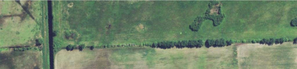
13 ± 210th St NW site 1 Monitoring Well 2 Monitoring Well 1 Monitoring Well 3 site 2 Monitoring Well 4 site 4 site 3 H:\Fargo\JBN\3400\3429\00_3429_014\Mitigation Site Monitoring\GPS Location map.mxd Site Locations Monitoring Wells Type 1 Wetlands - 11 Ac. Type 3 Wetlands - 40 Ac. Uplands - 25 Ac. site Feet
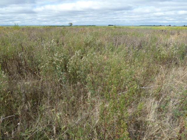
14 Attachment C Mitigation Site Photographs


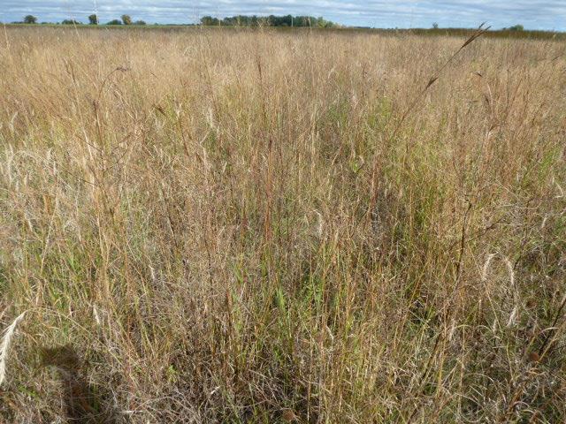

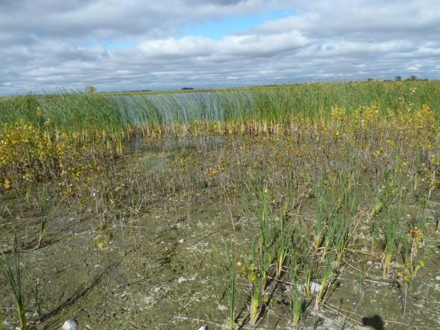
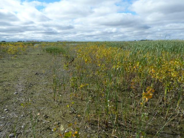
15 Site 1 Site 2 Site 3


16 Site 4 Site 5
5.15 Wetlands and Other Waters of the U.S.
 I-70 East Final EIS 5.15 Wetlands and Other Waters of the U.S. 5.15 Wetlands and Other Waters of the U.S. This section discusses wetlands, open waters, and other waters of the U.S. in the study area and
FIRST YEAR MONITORING REPORT
 FIRST YEAR MONITORING REPORT FOR WAY/ /MED-71-7.04/0.00 (PID 14017) USACE Permit: NWP 14# 200500803 OEPA ID#: 033596 STREAM MITIGATION AREA Prepared by The Ohio Department of Transportation Office of Environmental
Multi-Scale Monitoring of Potential Groundwater Withdrawal Impacts Using Delineation Methodology; Lower Platte River, Nebraska
 Multi-Scale Monitoring of Potential Groundwater Withdrawal Impacts Using Delineation Methodology; Lower Platte River, Nebraska Sarah Soard, PWS Burns & McDonnell Justin Bailey, PWS Burns & McDonnell Mike
Hinckley Wetland Mitigation Site
 Hinckley Wetland Mitigation Site Wetland Mitigation Plan Poly Met Mining Inc. May 2014 Hinckley Wetland Mitigation Site Wetland Mitigation Plan Poly Met Mining Inc. May 2014 Hinckley Wetland Mitigation
INFLOW DESIGN FLOOD CONTROL SYSTEM PLAN 40 C.F.R. PART PLANT YATES ASH POND 3 (AP-3) GEORGIA POWER COMPANY
 GEORGIA POWER COMPANY") INFLOW DESIGN FLOOD CONTROL SYSTEM PLAN 40 C.F.R. PART 257.82 PLANT YATES ASH POND 3 (AP-3) GEORGIA POWER COMPANY EPA s Disposal of Coal Combustion Residuals from Electric Utilities Final Rule (40 C.F.R.
INFLOW DESIGN FLOOD CONTROL SYSTEM PLAN 40 C.F.R. PART 257.82 PLANT YATES ASH POND 3 (AP-3) GEORGIA POWER COMPANY EPA s Disposal of Coal Combustion Residuals from Electric Utilities Final Rule (40 C.F.R.
Factors Associated with Invasive Plant Distribution Along Wisconsin Roadsides. Mark Renz & Joslyn Mink University of Wisconsin-Madison
 Factors Associated with Invasive Plant Distribution Along Wisconsin Roadsides. Mark Renz & Joslyn Mink University of Wisconsin-Madison Extent of Roadway System United States Roads cover 1% Ecologically
SECTION ONE: GENERAL INFORMATION
 The purpose of this survey is to gather information needed to develop guidelines for ecological restoration project planning in Minnesota. We are asking you to provide cost and time estimates for site
Duck s Unlimited Canada s Prairie CARE Program
 Duck s Unlimited Canada s Prairie CARE Program Diana Alfuth Duck s Unlimited Canada (DUC) is a private, non-profit conservation organization. It has been involved with waterfowl habitat restoration since
Restoration Theory and Practice
 Restoration Theory and Practice An Overview PCAP 2014 Native Prairie Restoration/Reclamation Workshop January 29 th, 2014 Regina, Sk Larry K. Gabruch Native Plant Solutions, Saskatoon OVERVIEW Project
SR 520 Medina to SR 202 Eastside Transit and HOV (Yarrow Creek Wetland) Mitigation Site USACE IP NWS
 Mitigation Site USACE IP NWS") SR 520 Medina to SR 202 Eastside Transit and HOV (Yarrow Creek Wetland) Mitigation Site USACE IP NWS-2009-562 Northwest Region 2018 MONITORING REPORT Wetlands Program Issued March 2019 Environmental Services
SR 520 Medina to SR 202 Eastside Transit and HOV (Yarrow Creek Wetland) Mitigation Site USACE IP NWS-2009-562 Northwest Region 2018 MONITORING REPORT Wetlands Program Issued March 2019 Environmental Services
Aitkin Wetland Mitigation Site
 Aitkin Wetland Mitigation Site Wetland Mitigation Plan Poly Met Mining Inc. May 2014 Aitkin Wetland Mitigation Site Wetland Mitigation Plan May 2014 Contents 1.0 Introduction... 1 2.0 Wetland Mitigation
Public Notice ISSUED: 11 February 2019 EXPIRES: 13 March 2019
 SPONSOR: Minnesota Board of Water and Soil Resources Public Notice ISSUED: 11 February 2019 EXPIRES: 13 March 2019 REFER TO: MVP-2019-0122-JTB SECTION: 404 - Clean Water Act 1. WETLAND COMPENSATORY MITIGATION
Wetland Assessment Report for Hawk Nest Park
 Wetland Assessment Report for Hawk Nest Park Location: A 20.18-acre parcel, located within part of the Hawk Nest Condominium development and further located within Section 36, Dewitt Township, Clinton
WETLAND DELINEATION REPORT
 WETLAND DELINEATION REPORT WHITMORE LAKE LOT WASHTENAW COUNTY, MICHIGAN JULY 2015 PREPARED FOR: WASHTENAW COUNTY PARKS AND RECREATION 2230 SOUTH PLATT ROAD ANN ARBOR, MICHIGAN 48104 PREPARED BY: THE MANNIK
Comparing revegetation methodologies for brush pile burn sites. Scott Gardner Mark Simmons Steve Windhager
 Comparing revegetation methodologies for brush pile burn sites Scott Gardner Mark Simmons Steve Windhager Initial Assumptions The process of burning brush creates a scar that seldom recovers to pre-existing
THE NEW WETLAND RULES How do they affect you? City Engineers Conference January 27, 2010
 THE NEW WETLAND RULES How do they affect you? City Engineers Conference January 27, 2010 Introduction Beth Kunkel, PWS Certified Professional Wetland Scientist Certified Wetland Delineator 22 years working
Will be modified map from GIS 6/16 EOD
 Middle-Snake-Tamarac Rivers Watershed District Judicial Ditch #19 Watershed Regional Conservation Partnership Program (RCPP) Public Scoping Meeting September 26, 2016 Will be modified map from GIS 6/16
Project No.: Prepared: December 2, 2011 The Ohio Department of Transportation; The Dawes Arboretum
 A Year 5 and Final Monitoring and Management Report, The Dawes Arboretum Mitigation Wetland Licking County, Ohio US Army Corps of Engineers Permit No. 200300260 Ohio EPA ID No. 052273 Project No.: 205101
I THOUGHT IT WAS JUST WET LAND: A GUIDE TO ENVIRONMENTAL PERMITTING FOR AIRPORTS ROAD SCHOOL 2018 SIMON DAVIES, SENIOR SCIENTIST MARCH 7, 2018
 I THOUGHT IT WAS JUST WET LAND: A GUIDE TO ENVIRONMENTAL PERMITTING FOR AIRPORTS ROAD SCHOOL 2018 SIMON DAVIES, SENIOR SCIENTIST MARCH 7, 2018 Definition Regulatory Definition - Those areas that are inundated
Lochmere Golf Course
 Lochmere Golf Course File No.: 199600376 City and State: Northfield, NH General Impacts: 3.76 acres Functions and Values Lost: (From EA/SOF) Floodflow Alteration Water Quality Maintenance Wildlife Habitat
SECTION 10: WETLANDS PROTECTION
 SECTION 10: WETLANDS PROTECTION 10-1 INTENT AND PURPOSE A. Intent 1. The City finds that wetlands serve a variety of beneficial functions. Wetlands maintain water quality, reduce flooding and erosion,
The following provides a summary of information required by Fort Collins Land Use Code under (D) (1) items (a) through (k).
 (1) items (a) through (k).") July 30, 2013 James Dullea Parker Land Investments, LLC. 9162 S. Kenwood Court Highlands Ranch, Colorado 80126 RE: Revised Ecological Characterization Study (ECS) Letter Report for the Proposed Waterfield
July 30, 2013 James Dullea Parker Land Investments, LLC. 9162 S. Kenwood Court Highlands Ranch, Colorado 80126 RE: Revised Ecological Characterization Study (ECS) Letter Report for the Proposed Waterfield
Upper Lightning Lake Water Level Management Environmental Assessment Worksheet. Attachment D Design Report for Upper Lightning Lake
 Upper Lightning Lake Water Level Management Environmental Assessment Worksheet Attachment D Design Report for Upper Lightning Lake DESIGN REPORT for Upper Lightning Lake Wetland Enhancement MN-332-2 I
Wallace Camp Auto. File No.: City and State: Westbrook, ME. General Impacts: 2.88 acres non-tidal wet meadow
 Wallace Camp Auto File No.: 199501767 City and State: Westbrook, ME General Impacts: 2.88 acres non-tidal wet meadow Functions and Values Lost: (From EA/SOF) Water Quality Maintenance Floodflow Alteration
INFLOW DESIGN FLOOD CONTROL SYSTEM PLAN PLANT GREENE COUNTY ASH POND ALABMA POWER COMPANY
 INFLOW DESIGN FLOOD CONTROL SYSTEM PLAN PLANT GREENE COUNTY ASH POND ALABMA POWER COMPANY Section 257.82 of EPA s regulations requires the owner or operator of an existing or new CCR surface impoundment
CONCEPTUAL COMPENSATORY MITIGATION PLAN for wetland losses
 CONCEPTUAL COMPENSATORY MITIGATION PLAN for wetland losses Teton County Idaho Reconstruction of W6000S, from Chapin Lane to W5750S May 21, 2015 Prepared for: Teton County Idaho Darryl Johnson, Public Works
Public Notice ISSUED: May 21, 2013 EXPIRES: June 20, 2013
 SPONSOR: REFER TO: Wisconsin Dept. of Transportation Public Notice ISSUED: May 21, 2013 EXPIRES: June 20, 2013 SECTION:404 - Clean Water Act 1. WETLAND COMPENSATORY MITIGATION BANK PROPOSAL 2. SPECIFIC
What is a Wetland? Common Wetland Names. Wetlands: Ecotones between Upland and Aquatic Systems. Matthew J. Gray University of Tennessee.
 What is a Wetland? Matthew J. Gray University of Tennessee Common Wetland Names Backwater swamps Peatland Estuary Vernal Pools Marsh Playa Fen Bog Bayou Spring Seep Humedales Wetlands: Ecotones between
Dahms West Pasture Mean FQI
 Mean FQI Mean N Reassessing Impacts of Kentucky Bluegrass on Prairie Plant Communities Chris Helzer, The Nature Conservancy November, 1 1 Degraded prairies are often characterized by low plant diversity
Project Started in 1990 on the Ron Risdal Farm. Ron Risdal
 Project Started in 1990 on the Ron Risdal Farm Ron Risdal Before/After on Specific Sites (1990-1994) Before/After on Specific Sites (1990-1994) Buffers On Lon Strum Farm Before Before Riparian Management
SPECIES COMPOSITION OF A CACHE VALLEY, UTAH PASTURE
 3 October 2004 Bart Simpson Department of Forest, Range, and Wildlife Sciences Utah State University Logan, UT 84321-5230 435-280-1567 eatmyshorts@cc.usu.edu RH: Species Composition of Ron Ryel s Property
ENGINEER S REPORT MAIN TILE IMPROVEMENTS DRAINAGE DISTRICT NO. 131 WRIGHT COUNTY
 ENGINEER S REPORT MAIN TILE IMPROVEMENTS DRAINAGE DISTRICT NO. 131 WRIGHT COUNTY 2013 TABLE OF CONTENTS Page I. Introduction 1 II. Background 1 III. Existing Conditions 1-4 IV. Improvement Options 4-6
Public Notice ISSUED: 26 December 2017 EXPIRES: 26 January 2018
 SPONSOR: Carex Group, LLC Public Notice ISSUED: 26 December 2017 EXPIRES: 26 January 2018 REFER TO: MVP-2015-01348-EJI SECTION:404 - Clean Water Act 1 WETLAND COMPENSATORY MITIGATION BANK PROPOSAL 2 SPECIFIC
Wetland Mitigation Crediting & Performance
 Wetland Mitigation Crediting & Performance Subhead for title slide BWSR Academy 2014 Overview Quick Review of Crediting Banking vs Impact Approvals & the Private Market Basic Requirements & Considerations
Native Seed Mixes and Orders -Quality Assurance
 PCAP -2012 Native Prairie/Reclamation Workshop February 8 9, 2012 Saskatoon Native Seed Mixes and Orders -Quality Assurance Larry K. Gabruch P.Ag Nature Conservancy of Canada Saskatchewan Region Parklands
INFLOW DESIGN FLOOD CONTROL SYSTEM PLAN PLANT BARRY ASH POND ALABAMA POWER COMPANY
 INFLOW DESIGN FLOOD CONTROL SYSTEM PLAN PLANT BARRY ASH POND ALABAMA POWER COMPANY Section 257.82 of EPA s regulations requires the owner or operator of an existing or new CCR surface impoundment or any
ME DOT Orrington Bypass
 File No.: 199301389 City and State: Hampden, ME ME DOT Orrington Bypass General Impacts: 2.2 acres palustrine forested, scrub-shrub, and emergent Functions and Values Lost: Groundwater Discharge Floodflow
Overcoming Challenges to Restore Native Tallgrass Prairie. University and U.S. Fish and Wildlife Service Partner to Find Solutions
 Sharing innovative research, success stories, and tips with invasive plant managers. SPRING Newsletter 2011 Prairie & Grasslands Edition Overcoming Challenges to Restore Native Tallgrass Prairie University
MnRAM Guidance on Selected Questions
 MnRAM Guidance on Selected Questions 1 1 Formula: Vegetative Integrity/Diversity There are four ways to report this function: Individual Community Scores: maintain raw data as recorded. Highest Quality
Appendix D Section Will 12
 Draft Wetland Delineation Report South Suburban Airport Master Plan Appendix D Section Will 12 Area ID Total Depth Hydric Soil Native FQI Comments UW12NE-1 NA NA NA Photo NE UW12NE-2 NA NA NA Photo S W12NE-3-S2
Environmental Information Worksheet
 Environmental Information Worksheet Water System Owner (Attach additional sheets if necessary) Needs and Alternatives Provide a brief narrative that describes: Current drinking water system needs. Project
PERFORMANCE STANDARDS AND MONITORING PROTOCOL FOR TIDAL WETLAND MITIGATION BANKS. October 28, 2016
 PERFORMANCE STANDARDS AND MONITORING PROTOCOL FOR TIDAL WETLAND MITIGATION BANKS October 28, 2016 A. Tidal wetland mitigation banks shall conform to the following performance standards by the end of the
INNOVATIVE, DIVERSIFIED AGROFORESTRY PLANTINGS IN SUPPORT OF ENERGY SECURITY, ENVIRONMENTAL QUALITY, AND LOCAL ECONOMIES
 INNOVATIVE, DIVERSIFIED AGROFORESTRY PLANTINGS IN SUPPORT OF ENERGY SECURITY, ENVIRONMENTAL QUALITY, AND LOCAL ECONOMIES ALTERNATIVE PERENNIALS IN AGROFORESTRY FEBRUARY 25, 2011 Joshua D. Gamble a, Gregg
INFLOW DESIGN FLOOD CONTROL SYSTEM PLAN 40 C.F.R. PART PLANT YATES ASH POND B (AP-B ) GEORGIA POWER COMPANY
 GEORGIA POWER COMPANY") INFLOW DESIGN FLOOD CONTROL SYSTEM PLAN 40 C.F.R. PART 257.82 PLANT YATES ASH POND B (AP-B ) GEORGIA POWER COMPANY EPA s Disposal of Coal Combustion Residuals from Electric Utilities Final Rule (40 C.F.R.
INFLOW DESIGN FLOOD CONTROL SYSTEM PLAN 40 C.F.R. PART 257.82 PLANT YATES ASH POND B (AP-B ) GEORGIA POWER COMPANY EPA s Disposal of Coal Combustion Residuals from Electric Utilities Final Rule (40 C.F.R.
Camden and Rockland Water Company
 Camden and Rockland Water Company File No.: 199201515 City and State: West Rockport, ME General Impacts: 1.13 acres of an unspecified type Functions and Values Lost: (From Compensation Plan) Groundwater
Conservation Partners Legacy Grant Program Annual Accomplishment Report Form
 Contract/ Organization Project Name PO Number 56632/3-31491 Heron Lake Watershed District HLWD Aquatic-Upland Prairie Restoration Person completing this report Daytime phone number Fiscal Year Reporting
Lakes Helen, Ellen and Barbara
 February 4, 2003 MEMORANDUM TO: File FROM: Doug Leeper, Senior Environmental Scientist Resource Conservation and Development Department Southwest Florida Water Management District SUBJECT: Proposed minimum
Basic Wetland Delineation in Minnesota
 Basic Wetland Delineation in Minnesota 2009 Wetland Delineator Certification Program (WDCP) Course MN Board of Water and Soil Resources University of Minnesota U.S. Army Corps of Engineers 1 Introductions
JOINT PUBLIC NOTICE U.S. ARMY CORPS OF ENGINEERS
 ISSUE DATE: February 23, 2018 EXPIRATION DATE: March 25, 2018 JOINT PUBLIC NOTICE U.S. ARMY CORPS OF ENGINEERS Availability of draft Environmental Assessment, draft Finding of No Significant Impact, and
S.R. 430, Segment 250 Offset 0000, Greenfield Township Wetland Delineation
 S.R. 430, Segment 250 Offset 0000, Greenfield Township Wetland Delineation Date: October 30, 2007 Re: To: From: Erie County SR 430 Segment 250 Offset 0000 Wetland Delineation Mr. Todd Palmer Bridge Unit
TREASURE COAST REGIONAL PLANNING COUNCIL M E M O R A N D U M. To: Council Members AGENDA ITEM 5E
 TREASURE COAST REGIONAL PLANNING COUNCIL M E M O R A N D U M To: Council Members AGENDA ITEM 5E From: Date: Subject: Staff March 15, 2013 Council Meeting Intergovernmental Coordination and Review Log The
AGRICULTURAL DRAINAGE
 AGRICULTURAL DRAINAGE ARCHITECTURE + ENGINEERING + True Expertise + Sustainable Solutions ENVIRONMENTAL + PLANNING Facing the Challenges Together With over 40 years of experience, ISG is focused on improving
Prepared by: Rummel, Klepper & Kahl
 WETLAND DELINEATION REPORT Kutztown Road (SR 1033) Resurfacing and Bridge Replacement Upper Hanover Township, Montgomery County, Pennsylvania Prepared for: PennDOT District 6-0 Prepared by: Rummel, Klepper
Public Notice ISSUED: May 20, 2016 EXPIRES: June 20, 2016
 SPONSOR: Howard Pender Public Notice ISSUED: May 20, 2016 EXPIRES: June 20, 2016 REFER TO: 2014-03696-LSP SECTION: 404 - Clean Water Act 1. WETLAND COMPENSATORY MITIGATION BANK PROPOSAL 2. SPECIFIC INFORMATION.
Indiana University Campus Wetland Survey 2010 Final Report Kari Metcalf
 Indiana University Campus Wetland Survey 2010 Final Report Kari Metcalf INTRODUCTION Following recommendations by the Indiana Department of Environmental Management, Indiana University inventoried jurisdictional
Managing Prairies for Biological Diversity and Ecological Resilience. Chris Helzer, The Nature Conservancy - Nebraska
 Managing Prairies for Biological Diversity and Ecological Resilience Chris Helzer, The Nature Conservancy - Nebraska Platte River Prairies - Nebraska 25-28 annual rainfall Lowland tallgrass and upland
Wetland Rehabilitation in a Reservoir Setting Wetland Habitat Enhancement: U.S. 95 Sand Creek Byway Josh Butler & Gretchen Herron CH2M HILL Inc.
 Wetland Rehabilitation in a Reservoir Setting Wetland Habitat Enhancement: U.S. 95 Sand Creek Byway & Gretchen Herron CH2M HILL Inc., Boise, Idaho CONTENTS 1. Background & Design Basis 2. Construction
AGRICULTURAL DRAINAGE
 AGRICULTURAL DRAINAGE ARCHITECTURE + ENGINEERING + ENVIRONMENTAL + PLANNING True Expertise + Sustainable Solutions Facing the Challenges Together With over 40 years of experience, ISG is focused on improving
Flowering Rush Delineation, Control, and Assessment for Forest Lake, Washington County, Minnesota, 2016
 in Forest Lake, July, 2016, Control, and Assessment for Forest Lake, Washington County, Minnesota, 2016 : July 14 and 15, 2016 Herbicide Treatments on 36 acres: August 3 and 31, 2016 Assessment: September
Alfalfa Medicago sativa L.
 FORAGE IDENTIFICATION Alfalfa Medicago sativa L. Winter Hardiness Very High Drought Tolerance Bloat Hazard Yes Hay, silage, pasture, green manure crop. Northern half; increasing acreage in the Southeast
How to avoid getting bogged down by the Nova Scotia Wetland Conservation Policy
 How to avoid getting bogged down by the Nova Scotia Wetland Conservation Policy for the Environmental Services Association of Nova Scotia By Krista Hilchey Wetland Specialist, Nova Scotia Environment To
Public Notice ISSUED: March 17, 2016 EXPIRES: April 17, 2016
 SPONSOR: Stanley Antolick Public Notice ISSUED: March 17, 2016 EXPIRES: April 17, 2016 REFER TO: 2015-01201-LMG SECTION:404 - Clean Water Act 1. WETLAND COMPENSATORY MITIGATION BANK PROPOSAL 2. SPECIFIC
Waters of the U.S. Revisions
 City and County of Denver January 12 2015 Denver International Airport Waters of the U.S. Revisions Sarah Reeves, Brown and Caldwell Waters of the US (WOTUS) Clean Water Act... protects waters to keep
APPENDIX III Hydrologic and Hydraulic Evaluations
 APPENDI III Hydrologic and Hydraulic Evaluations Hydrologic and Hydraulic Analysis Related to Compliance Requirements South Fly Ash Pond, Boiler Slag Pond and Clearwater Pond Kyger Creek Power Plant, Gallia
Fargo-Moorhead Flood Risk Management Project Supplement to Environmental Impact Statement (SEIS) Final Preparation Notice May 21, 2018
 Final Preparation Notice May 21, 2018") Fargo-Moorhead Flood Risk Management Project Supplement to Environmental Impact Statement (SEIS) Final Preparation Notice May 21, 2018 1. Title of EIS being supplemented and date of completion: Final Environmental
Fargo-Moorhead Flood Risk Management Project Supplement to Environmental Impact Statement (SEIS) Final Preparation Notice May 21, 2018 1. Title of EIS being supplemented and date of completion: Final Environmental
FEMA/USACE Coordination Plan
 FEMA/USACE Coordination Plan Project: Fargo-Moorhead Metropolitan Feasibility Study ND Diversion Channel with upstream staging Federal Plan (Authorized WRRDA 2014) Project Design: Project Reach: U.S. Army
Natural and Engineered Wetlands for Stormwater Management
 Natural and Engineered Wetlands for Stormwater Management Dan Hitchcock, Ph.D., P. E. Baruch Institute of Coastal Ecology and Forest Science Clemson University Georgetown, SC Prominence and Diversity of
Wetland Identification/Delineation and Bog Turtle Habitat Screening Report for. S.R. 0097, Section 003 Two Taverns Bridge Replacement over Littles Run
 Wetland Identification/Delineation and Bog Turtle Habitat Screening Report for S.R. 0097, Section 003 Two Taverns Bridge Replacement over Littles Run June 2003 Prepared for: The Pennsylvania Department
Public Notice ISSUED: 17 April 2018 EXPIRES: 17 May 2018
 SPONSOR: Kevin Root Public Notice ISSUED: 17 April 2018 EXPIRES: 17 May 2018 REFER TO: MVP-2017-00698-BBY SECTION: 404 - Clean Water Act 1. WETLAND COMPENSATORY MITIGATION BANK PROPOSAL 2. SPECIFIC INFORMATION
Passive Reduction of Salts and Nitrate from Greenhouse Effluent by Planted Bioreactors
 Evaluation of Passive Reduction of Salts and Nitrate from Greenhouse Effluent by Planted Bioreactors Soheil Fatehi Pouladi* Bruce Anderson* Brent Wootton Lloyd Rozema *Civil Engineering Dept. Queen s University
Model Results Operation and Maintenance (O& M) Results Cost-Benefit Analysis Results Conclusions
 Results Cost-Benefit Analysis Results Conclusions") BMP Performance and Outline Background Model Results Operation and Maintenance (O& M) Results Results Conclusions Melissa Baker, Water Resource Technician Capitol Region Watershed District, St. Paul, MN
BMP Performance and Outline Background Model Results Operation and Maintenance (O& M) Results Results Conclusions Melissa Baker, Water Resource Technician Capitol Region Watershed District, St. Paul, MN
LIST OF APPENDICES. Appendix B. Plans of Freshwater Wetland Components and Modeled Alternatives
 LIST OF APPENDICES Appendix A. Hydrologic Budget Results Appendix B. Plans of Freshwater Wetland Components and Modeled Alternatives Appendix C. Wetland Zones Appendix D. Cost Sheets Appendix E. Alternative
Forecast Informed Reservoir Operations for Groundwater Recharge Prado Dam
 Forecast Informed Reservoir Operations for Groundwater Recharge Prado Dam Greg Woodside Orange County Water District Bridging the Gap Conference January 29, 2019 Anaheim Army Corps of Engineers & OCWD
III. INVENTORY OF EXISTING FACILITIES
 III. INVENTORY OF EXISTING FACILITIES Within the Growth Management Boundary, the existing storm drainage facilities are largely associated with development that has historically occurred in the ten drainage
COON CREEK WATERSHED DISTRICT PERMIT REVIEW Mississippi Dr Coon Rapids, MN SQ FT Residence on 0.64 Acre Lot
 17-082 Van Sloun Residence, Page 1 of 5 COON CREEK WATERSHED DISTRICT PERMIT REVIEW MEETING DATE: May 8, 2017 AGENDA NUMBER: 17 FILE NUMBER: 17-082 ITEM: Van Sloun Residence RECOMMENDATION: Approve with
Grand Marais Creek Outlet Restoration Appendix
 Grand Marais Creek Outlet Restoration Appendix TABLE OF CONTENTS RLWD Project 60F Grand Marais Creek Outlet Restoration Final Engineer s Plan Report to the Board of Managers of the Red Lake Watershed District
SW-74 SERENOVA PRESERVE SITES 2, 3, 4, 8 MITIGATION PLAN
 SW-74 SERENOVA PRESERVE SITES 2, 3, 4, 8 MITIGATION PLAN BACKGROUND INFORMATION Project SWIM? Aquatic Control? Exotic Control? Mitigation Bank? Type No No No No Mitigation Restoration and enhancement Type
NJDEP Regulations that impact or soon will impact agricultural operations. April 1, 2007 Horses 2007
 NJDEP Regulations that impact or soon will impact agricultural operations. April 1, 2007 Horses 2007 Peter L. Kallin, Ph.D., P.W.S. Phone: 732-499-3600 Ext. 237 E-mail: pkallin@aesop.rutgers.edu www.water.rutgers.edu
AMERICAN ELECTRIC POWER (SWEPCO)
") 2016 DAM & DIKE INSPECTION REPORT ASH PONDS GERS-16-163 WELSH POWER PLANT AMERICAN ELECTRIC POWER (SWEPCO) CASON, TEXAS NATIONAL INVENTORY NO. TX4357 PREPARED BY GEOTECHNICAL ENGINEERING AEP SERVICE CORPORATION
2016 DAM & DIKE INSPECTION REPORT ASH PONDS GERS-16-163 WELSH POWER PLANT AMERICAN ELECTRIC POWER (SWEPCO) CASON, TEXAS NATIONAL INVENTORY NO. TX4357 PREPARED BY GEOTECHNICAL ENGINEERING AEP SERVICE CORPORATION
Distributed Storage Alternative Screening Analysis February 17, 2015
 Distributed Storage Alternative Screening Analysis February 17, 2015 Executive Summary The Distributed Storage Alternative (DSA) was conceptualized during the public comment and alternative screening process
SR nd Street SE to 112th Street SE (527 Widening) Mitigation Site WIN # A52720B USACE NWP (14)
 Mitigation Site WIN # A52720B USACE NWP (14)") SR 527 132nd Street SE to 112th Street SE (527 Widening) Mitigation Site WIN # A52720B USACE NWP (14) 2002-00046 Northwest Region 2016 MONITORING REPORT Wetlands Program Issued March 2017 Environmental
SR 527 132nd Street SE to 112th Street SE (527 Widening) Mitigation Site WIN # A52720B USACE NWP (14) 2002-00046 Northwest Region 2016 MONITORING REPORT Wetlands Program Issued March 2017 Environmental
Routine Wetland Determination
 Project/Site: 60-0008-0560-0032 Applicant/owner: PENNDOT, Eng. District 1-0 Investigator(s): Christopher R. Wolfgong Routine Wetland Determination DATA FORM 1 (Revised) 1987 Corps Wetland Delineation Manual)
INFLOW DESIGN FLOOD CONTROL SYSTEM PLAN PLANT GASTON GYPSUM POND ALABAMA POWER COMPANY
 INFLOW DESIGN FLOOD CONTROL SYSTEM PLAN PLANT GASTON GYPSUM POND ALABAMA POWER COMPANY Section 257.82 of EPA s regulations requires the owner or operator of an existing or new CCR surface impoundment or
Chapter 2. Watershed Characteristics
 Chapter 2. Watershed Characteristics The Pelican Lakes are glacial lakes formed during the last retreat of the Red River Lobe starting about 13,000 years ago. The soils deposited by the glacier are primarily
Taking Action to Protect UW-Stout s Last Remaining Wetland
 Taking Action to Protect UW-Stout s Last Remaining Wetland Maxine Pettis Undergraduate Student, Applied Science Key words: Wetland delineation, wetland indicators, hydrophytic vegetation, hydric soils,
Ordinary High Water Mark
 Ordinary High Water Mark Town of Long Beach Advisory Plan Commission Hearing on The Proposed Lake Michigan Shoreline Preservation and Enhancement Overlay District Ordinance May 24, 2018 Ordinary High Water
Appendix C-3. Wetlands and Other Surface Waters Report
 Appendix C-3 Wetlands and Other Surface Waters Report WETLANDS AND OTHER SURFACE WATERS REPORT Hatchet Ridge Wind Energy Project Shasta County, California Prepared for: Hatchet Ridge Wind, LLC Portland,
US ARMY CORPS Reply To: Public Notice No. OF ENGINEERS U.S. Army Corps of Engineers P-3121
 US ARMY CORPS Reply To: Public Notice No. OF ENGINEERS U.S. Army Corps of Engineers P-3121 St. Louis District Attn: CEMVS-OD-F Gateway to Excellence 1222 Spruce Street Public Notice Date: St. Louis, Missouri
PROPOSED RESTORATION PLAN
 4 PROPOSED RESTORATION PLAN Restoring Natural Function Goals and Objectives Restoration of hydrologic function is the main goal of floodplain restoration. Other goals include values derived from the restored
Constructing Wetlands for Wastewater Treatment: Design Considerations & Strategies for Success
 Constructing Wetlands for Wastewater Treatment: Design Considerations & Strategies for Success Metropolitan Water Reclamation District of Greater Chicago and V3 Companies Introductions Jennifer Maercklein,
Performance Standards for Target Hydrology
 Performance Standards for Target Hydrology Steve Eggers Senior Ecologist Regulatory Branch St. Paul District December 10, 2015 US Army Corps of Engineers Introduction Target Hydrology: the hydrology necessary
Municipal Stadium Wetland
 W A T E R S H E D F A C T S Total watershed area 140 mi 2 Average annual rainfall 38 in Average annual temperature 58 F Elevation Max 1321 ft Min 899 ft C. J. Brown Reservoir controls flow from 83 mi 2
Constructed Wetland Pond T-8
 Constructed Wetland Pond T-8 Description A constructed wetlands pond is a shallow retention pond designed to permit the growth of wetland plants such as rushes, willows, and cattails. Constructed wetlands
INITIAL RUN-ON AND RUN-OFF CONTROL PLAN 40 C.F.R. PART 257
 INITIAL RUN-ON AND RUN-OFF CONTROL PLAN 40 C.F.R. PART 257.81 HUFFAKER ROAD (PLANT HAMMOND) PRIVATE INDUSTRIAL LANDFILL (HUFFAKER ROAD LANDFILL) GEORGIA POWER COMPANY EPA s Disposal of Coal Combustion
Objectives. Rationale
 Evaluation of Traditional and Novel Species for Reducing Sediment Loss in North Central Indiana Kristie S. Walker, Cale A. Bigelow, Doug R. Smith, and Glenn Hardebeck Objectives Phase 1: Identify alternative
SAN LORENZO VALLEY WATER DISTRICT CAMPUS CENTER PROJECT WETLAND MITIGATION AND MONITORING PLAN. San Lorenzo Valley Water District
 SAN LORENZO VALLEY WATER DISTRICT CAMPUS CENTER PROJECT WETLAND MITIGATION AND MONITORING PLAN Prepared For: San Lorenzo Valley Water District Prepared By: Denise Duffy & Associates, Inc. 947 Cass St.
Information for File # TAW
 Information for File #2013-01458-TAW Applicant: Goodhue County, c/o Mr. Marty Dale Corps Contact: Travis Wiley, U.S. Army Corps of Engineers, 180 5 th Street East, Suite 700, St. Paul, MN, 55101-1678;
Wetland Delineation. Richard L. Darden, Ph.D. U.S. Army Corps of Engineers Charleston District October 3, 2012 BUILDING STRONG
 Wetland Delineation Richard L. Darden, Ph.D. U.S. Army Corps of Engineers Charleston District October 3, 2012 Why Delineate Wetlands? To define the limits of federal jurisdiction, in accordance with current
INFLOW DESIGN FLOOD CONTROL SYSTEM PLAN 40 C.F.R. Part PLANT MCINTOSH ASH POND 1 GEORGIA POWER COMPANY
 INFLOW DESIGN FLOOD CONTROL SYSTEM PLAN 40 C.F.R. Part 257.82 PLANT MCINTOSH ASH POND 1 GEORGIA POWER COMPANY EPA s Disposal of Coal Combustion Residuals from Electric Utilities Final Rule (40 C.F.R. Part
ABBREVIATED NOTICE OF RESOURCE AREA DELINEATION YANKEE NUCLEAR POWER STATION ROWE, MASSACHUSETTS MARCH 2004 PREPARED FOR
 ABBREVIATED NOTICE OF RESOURCE AREA DELINEATION YANKEE NUCLEAR POWER STATION ROWE, MASSACHUSETTS MARCH 2004 PREPARED FOR YANKEE ATOMIC ELECTRIC COMPANY 49 YANKEE ROAD ROWE, MASSACHUSETTS 01367 PREPARED