Estimating Soil Carbon Sequestration Potential: Regional Differences and Remote Sensing
|
|
|
- Griffin Cox
- 5 years ago
- Views:
Transcription
1 Estimating Soil Carbon Sequestration Potential: Regional Differences and Remote Sensing Tris West Environmental Sciences Division Technical Working Group on Agricultural Greenhouse Gases (T-AGG): Experts Meeting Chicago, Illinois April 22 & 23, 2010
2 Regional Differences: Causes Climate Annual weather Soils (texture and water holding capacity) Management (crop rotation; tillage & residue management; manure & grazing management) Management can be manipulated, and is currently done through conservation programs and education 2 Managed by UT-Battelle
3 Regional Differences: Some Results 3 Managed by UT-Battelle West and Six Climatic Change 80:
4 Regional Differences: Sequestration Dynamics Soil carbon (a) Soil carbon (b) Saturation level Steady State 2 Sd 3 C 3 R 3 Sd C 1 2 R 2 Steady State 1 Sd 2 C 1 R 1 D2 D 1 Time I 1 I 2 I 3 D 3 Carbon input 4 Managed by UT-Battelle West and Six Climatic Change 80:
5 Sequestration potential can be defined as: (1) Sequestration rate (soil carbon accumulation per unit area and per soil depth) X (2) Potential land area available for carbon sequestration activities = (3) Total carbon sequestration potential 5 Managed by UT-Battelle
6 Use of Remote sensing data and products for modeling agricultural systems and soil carbon sequestration Identify crops and fields [EVI, NDVI] Identify underlying soil attributes Estimate management practices [CAI] Estimate NPP [LAI] All of the above can be developed in conjunction with existing inventory data. 6 Managed by UT-Battelle
7 Integration of field data, inventory data, and remote sensing for soil carbon accounting Land cover County boundaries Carbon dynamics based on analyses of field data Spatial data: Composite data set of land cover classes, county boundaries, and spatial soil units Final product: Spatiallydelineated changes in soil carbon updated annually Soil carbon Data: Harvested crop area per county 7 Data: Tillage intensity per crop per county Managed by UT-Battelle West et al Soil Science Society of America Journal 72:


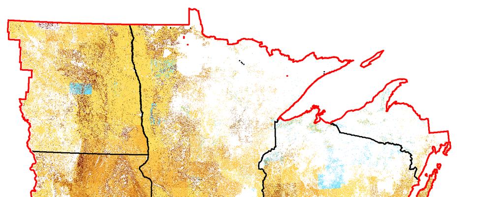
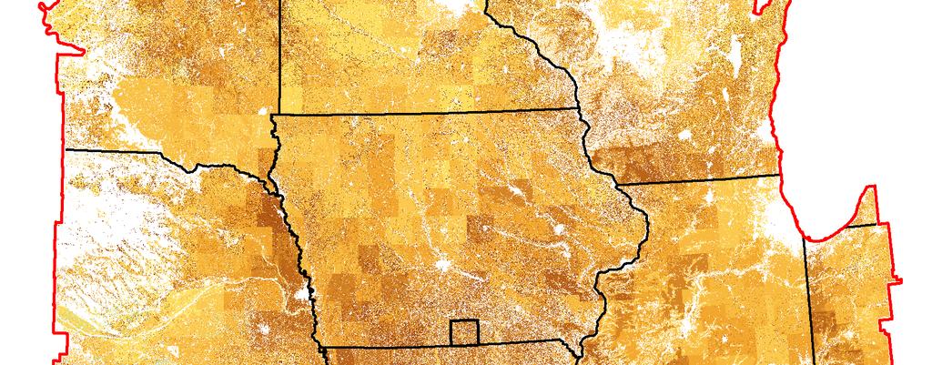
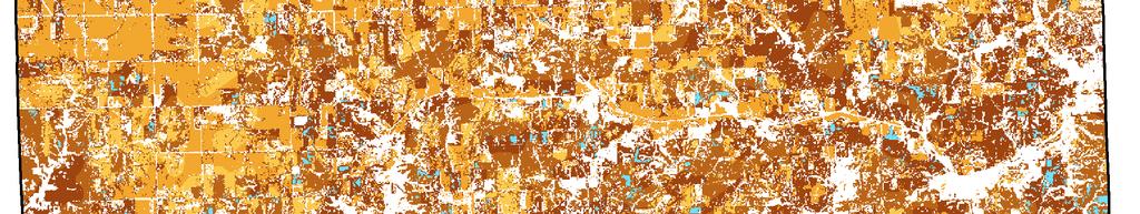
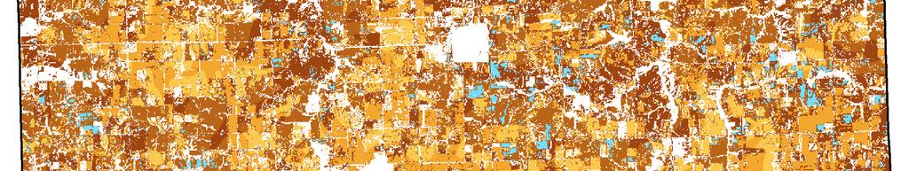

8 Soil carbon change, Results commensurate with 30m-resolution Landsat-based Land Cover Data 8 Managed by UT-Battelle West et al Soil Science Society of America Journal 72:
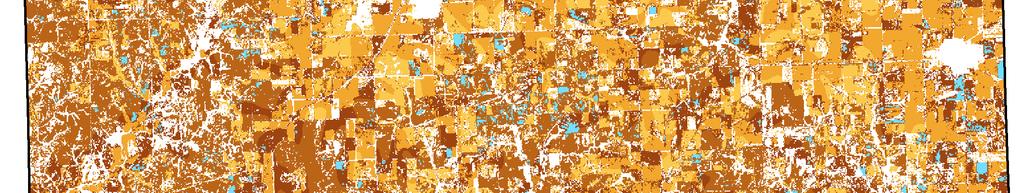
9 Geospatial estimates of net carbon flux from croplands Results commensurate with 1km-resolution MODIS-based Land Cover Data On-site net carbon flux from US croplands in 2004 associated with land management = -C uptake +decomposition soil C accumulation +fossil CO2 emissions +CO2 from aglime. Net negative flows FROM the atmosphere, net positive flows TO the atmosphere. 9 Managed by UT-Battelle Method and more recent results in West et al. Ecological Applications (in press)


 Bondville,")


 (d) CDL 2003")
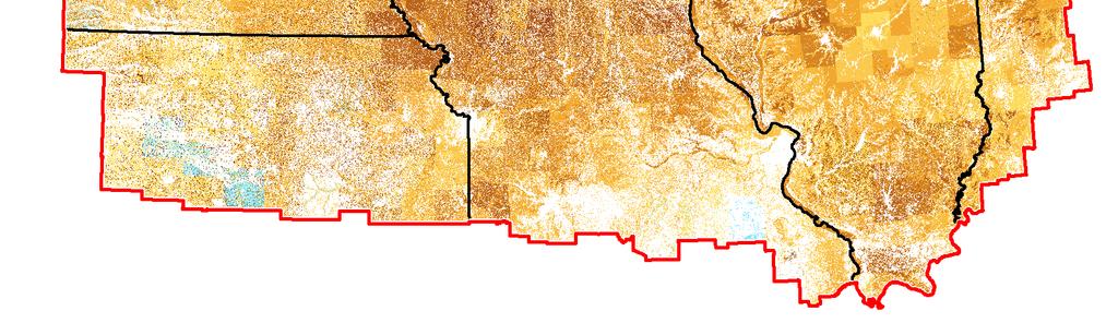
10 Moving from MODIS to Cropland Data Layer, including use of flux tower measurements (a) (b) Bondville, Illinois flux site as represented by the Cropland Data Layer CDL 2001 CDL 2002 (c) (d) CDL 2003 CDL Managed by UT-Battelle
11 Annually aggregated NEE from Bondville flux tower compared to our C accounting approach, using different land cover data sets 0 Estimated net ec cosystem exchange for corn/soyb bean rotation in Bondville, Il llinois (g C yr -1 ) Flux Tower CDL-based estimate MODIS-based estimate County-based estimate Time (yr) NEE = estimated -NPP + harvested carbon + decomposed biomass + soil carbon change + CO2 from lime application + on-farm fossil fuel emissions 11 Managed by UT-Battelle
12 Shift in crop phenology does not always change annual yield, but does change temporal signature of carbon uptake and release 1 Average MODIS NDV VI for Iowa Crops Corn (2007) Corn (2008) Soybean (2007) Soybean (2008) Day of the Year (DOY) 12 Managed by UT-Battelle NDVI processed by Prasad Bandaru, ORNL
13 Ideal sensor for agricultural monitoring Important bands: 480 nm (blue) 550 nm (green) 670 nm (red) 710 nm (red-edge) 850 nm (NIR) 1650 nm (SWIR) 2030 nm (SWIR) 2100 nm (SWIR) 2210 nm (SWIR) 11 & 12 µm (Thermal IR) aerosols chlorophyll vegetation cover chlorophyll vegetation cover vegetation water content cellulose cellulose cellulose vegetation stress, ET 13 Managed by UT-Battelle Compiled by Guy Serbin (USDA Foreign Agriculture Service)
14 Conclusions Integration of ACTUAL cropland cover, annually, nationally can be done now, further development of standardized approach could be considered Integration of crop phenology (inter-annual carbon uptake and residue contribution) per crop species can be done in near future (1-3 years). Crop residue management needs long-term effort (5+ years). National database on soils and on land management, with focus on soil carbon change, could be better coordinated and possibly revised (i.e., SSURGO, NRI, USDA NASS, USDA ERS) 14 Managed by UT-Battelle
15 15 Managed by UT-Battelle


16 Estimating Future Land Management and Carbon Budgets Predicting land-use change Improved estimates of available land for bioenergy crops 16 Managed by UT-Battelle
Energy Inputs for 1 st and 2 nd Generation Ethanol Feedstocks: Modeling Effects of Cultivation Practices and Crop Selection on GHG Emissions
 Energy Inputs for 1 st and 2 nd Generation Ethanol Feedstocks: Modeling Effects of Cultivation Practices and Crop Selection on GHG Emissions Tristram O. West, Laurence M. Eaton, Chad Hellwinckel,* Mark
Remote Sensing Uses in Agriculture at NASS
 Remote Sensing Uses in Agriculture at NASS United States Department of Agriculture (USDA) National Agriculture Statistics Service (NASS) Research and Development Division Geospatial Information Branch
Estimating the Overall Impact of A Change In Agricultural Practices on Atmospheric CO 2
 Estimating the Overall Impact of A Change In Agricultural Practices on Atmospheric CO 2 T.O. West (westto@ornl.gov; 865-574-7322) G. Marland (marlandgh@ornl.gov; 865-241-4850) Environmental Sciences Division,
COMET-FARM and COMET-Planner Updates
 COMET-FARM and COMET-Planner Updates C-AGG Chicago July 19, 2017 Keith Paustian, Mark Easter, Amy Swan, Steve Williams, and Kevin Brown Natural Resource Ecology Laboratory & Dept. Soil and Crop Sciences
USDA GLOBAL CHANGE FACT SHEET
 USDA GLOBAL CHANGE FACT SHEET Greenhouse Gas Emissions and Agriculture and Forestry The global concentration of greenhouse gases in the atmosphere has increased measurably over the past 250 years, partly
Biogeochemical Consequences of Land Use Transitions Along Brazil s Agricultural Frontier
 Biogeochemical Consequences of Land Use Transitions Along Brazil s Agricultural Frontier Gillian Galford* 1,2, John Mustard 1, Jerry Melillo 2, Carlos C. Cerri 3, C.E.P. Cerri 3, David Kicklighter 2, Benjamin
CROP STATE MONITORING USING SATELLITE REMOTE SENSING IN ROMANIA
 CROP STATE MONITORING USING SATELLITE REMOTE SENSING IN ROMANIA Dr. Gheorghe Stancalie National Meteorological Administration Bucharest, Romania Content Introduction Earth Observation (EO) data Drought
Remote Sensing for Monitoring USA Crop Production: What is the State of the Technology
 Remote Sensing for Monitoring USA Crop Production: What is the State of the Technology Monitoring Food Security Threats from Space - A CELC Seminar Centurion, SA 21 April 2016 David M. Johnson Geographer
To provide timely, accurate, and useful statistics in service to U.S. agriculture
 NASS MISSION: To provide timely, accurate, and useful statistics in service to U.S. agriculture What does NASS do? Administer USDA s Statistical Estimating Program Conduct the 5-year Census of Agriculture
Quantifying CO 2 fluxes of boreal forests in Northern Eurasia
 Quantifying CO 2 fluxes of boreal forests in Northern Eurasia Integrated analyses of in-situ eddy flux tower, remote sensing and biogeochemical model Xiangming Xiao Institute for the Study of Earth, Oceans
Biogeochemical Cycling Studies
 Biogeochemical Cycling Studies Fort Benning, GA 1999-2009 Bill Goran and Hal Balbach US Army Engineer Research and Development Center Champaign, IL Shuguang (Leo) Liu USGS Earth Resources Observation and
Strategies for Mitigating Rice GHG Emissions: Modeling and Geospatial Monitoring
 Strategies for Mitigating Rice GHG Emissions: Modeling and Geospatial Monitoring April 23, 2010 William Salas Applied Geosolutions, LLC Durham, NH 03924 USA wsalas@agsemail.com APPLIED GEOSOLUTIONS, LLC
Carbon sequestration in China s ecosystems, Jingyun Fang Department of Ecology Peking University
 Carbon sequestration in China s ecosystems, 1981-2000 Jingyun Fang Department of Ecology Peking University Feb. 14, 2008 IPCC (2007) Most of the observed increase in global temperatures since the mid-20th
Daily Monitoring of Rangeland and Pasture using 30m Vegetation Index for USDA LTAR Sites
 5 th GEOGLAM RAPP Workshop, May 16-17, 2017, Frascati, Italy Daily Monitoring of Rangeland and Pasture using 30m Vegetation Index for USDA LTAR Sites Feng Gao 1, Rowan Gaffney 2, David Augustine 2, Lauren
Potential for Sustainable Deployment of Biofuels Under EISA
 Potential for Sustainable Deployment of Biofuels Under EISA American Chemical Society Science & the Congress Briefing on Cellulosic Biofuels Virginia H. Dale Oak Ridge National Laboratory Washington, D.C.
Rapid Land Use and Land Cover Database Development
 Rapid Land Use and Land Cover Database Development Utility of the Land Use and Land Cover Database Socio-Economic Climate Change Water Quantity Water Quality 2 Overview of the Mapping Approach Goal: Develop
Tools and Methods to Manage Carbon Sequestration in Agriculture and Forestry
 Tools and Methods to Manage Carbon Sequestration in Agriculture and Forestry Marci Baranski, PhD Climate Change Specialist U.S. Department of Agriculture Policy imperative UNFCCC commitment USDA Building
Greenhouse gases and agricultural: an introduction to the processes and tools to quantify them Richard T. Conant
 Greenhouse gases and agricultural: an introduction to the processes and tools to quantify them Richard T. Conant Natural Resource Ecology Laboratory Colorado State University Perturbation of Global Carbon
Overview of the EPRI-MSU Nitrous Oxide (N 2 O) Greenhouse Gas Emissions Offsets Methodology
 Greenhouse Gas Emissions Offsets Methodology") Overview of the EPRI-MSU Nitrous Oxide (N 2 O) Greenhouse Gas Emissions Offsets Methodology Adam Diamant Senior Project Manager EPRI Global Climate Program Joint C-AGG, T-AGG, M-AGG Meeting Chicago, IL
Overview of the EPRI-MSU Nitrous Oxide (N 2 O) Greenhouse Gas Emissions Offsets Methodology Adam Diamant Senior Project Manager EPRI Global Climate Program Joint C-AGG, T-AGG, M-AGG Meeting Chicago, IL
Land Surface Monitoring from the Moon
 Land Surface Monitoring from the Moon Jack Mustard, Brown University Workshop on Science Associated with Lunar Exploration Architecture Unique Perspective of Lunar Observation Platform Low Earth Orbit:
Evaluating and improving cover crop performance and adoption
 Evaluating and improving cover crop performance and adoption W. Dean Hively U.S. Geological Survey Eastern Geographic Science Center U.S. Department of the Interior U.S. Geological Survey NESARE Cover
The Economic and Policy Challenges of Biofuels
 The Economic and Policy Challenges of Biofuels Madhu Khanna Department of Agricultural and Consumer Economics University of Illinois, Urbana-Champaign Economic, Environmental and Policy Challenges Growing
AGOG 485/585 APLN 533 Spring 2019
 AGOG 485/585 APLN 533 Spring 2019 Outline Vegetation analysis and related MODIS products Phenology and productivity Fire monitoring using MODIS and VIIRS data Readings: Textbook Chapter 17 FAQ on Vegetation
Remote Sensing and Image Processing: 9
 Remote Sensing and Image Processing: 9 Dr. Mathias (Mat) Disney UCL Geography Office: 301, 3rd Floor, Chandler House Tel: 7670 4290 (x24290) Email: mdisney@geog.ucl.ac.uk www.geog.ucl.ac.uk/~mdisney 1
Production of Biofuels Feedstock on Agriculture Land and Grasslands
 Production of Biofuels Feedstock on Agriculture Land and Grasslands W. W. Wilhelm 1, Gary Varvel 1, Rob Mitchell 2, and Brian Wienhold 1 1 Agroecosystem Management Research Unit 2 Grain, Forage, and Bioenergy
REMOTE SENSING, NORMALIZED DIFFERENCE VEGETATION INDEX (NDVI), AND CROP YIELD FORECASTING XIJIE LV THESIS
, AND CROP YIELD FORECASTING XIJIE LV THESIS") REMOTE SENSING, NORMALIZED DIFFERENCE VEGETATION INDEX (NDVI), AND CROP YIELD FORECASTING BY XIJIE LV THESIS Submitted in partial fulfillment of the requirements for the degree of Master of Science in
REMOTE SENSING, NORMALIZED DIFFERENCE VEGETATION INDEX (NDVI), AND CROP YIELD FORECASTING BY XIJIE LV THESIS Submitted in partial fulfillment of the requirements for the degree of Master of Science in
New Tech Predicts Local Corn Supply. -The Opportunities and Limits of Statistical Ag Data-
 New Tech Predicts Local Corn Supply -The Opportunities and Limits of Statistical Ag Data- Presented by: Steffen Mueller, PhD Principal Economist Biofuel and Bioenergy Research University of Illinois at
Evaluation of Nutrient Use Efficiency Using County and Hydrologic Unit Nutrient Budgets for U.S. Cropland and Soil Test Summaries
 Evaluation of Nutrient Use Efficiency Using County and Hydrologic Unit Nutrient Budgets for U.S. Cropland and Soil Test Summaries ASA-CSSA-SSSA International Annual Meeting November 3, 2009 Paul E. Fixen,
Availability of Biomass Feedstocks in the Appalachian Region
 Availability of Biomass Feedstocks in the Appalachian Region Appalachian Woody Biomass to Ethanol Conference Bob Perlack Oak Ridge National Laboratory September 5, 2007 Managed by UT-Battelle Quick review
Remote Sensing (C) Team Name: Student Name(s):
 Team Name: Student Name(s):") Team Name: Student Name(s): Remote Sensing (C) Nebraska Science Olympiad Regional Competition Henry Doorly Zoo Saturday, February 27 th 2010 96 points total Please answer all questions with complete sentences
Team Name: Student Name(s): Remote Sensing (C) Nebraska Science Olympiad Regional Competition Henry Doorly Zoo Saturday, February 27 th 2010 96 points total Please answer all questions with complete sentences
Manag Mana in g g Soil Carbon to Imp to Im rove Water Qualit Douglas L. Douglas L Karlen USDA USDA--ARS National ARS National Soil Tilth Lab REAP
 Managing g Soil Carbon to Improve Water Quality Douglas L. Karlen USDA-ARS ARS National Soil Tilth Lab Presentation Outline Climate & agricultural effects on soil carbon How soil carbon affects soil quality
Remote Sensing of Land & Vegetation. C S Murthy
 Remote Sensing of Land & Vegetation C S Murthy Remote Sensing current status New era of RS in 21 st Century Increased utilisation of data Quantitative algorithms/improved retrieval methods Better calibrations
Biofuels: Costs and Potential for Mitigating Greenhouse Gases
 Biofuels: Costs and Potential for Mitigating Greenhouse Gases Madhu Khanna Department of Agricultural and Consumer Economics Energy Biosciences Institute University of Illinois, Urbana-Champaign GHG Emissions
The role of Remote Sensing in Irrigation Monitoring and Management. Mutlu Ozdogan
 The role of Remote Sensing in Irrigation Monitoring and Management Mutlu Ozdogan Outline Why do we care about irrigation? Remote sensing for irrigated agriculture What are the needs of irrigators? Future
Climate Data and Drought Research
 Climate Data and Drought Research Can NLWIS Help the Drought Research Initiative? A. Howard: Agriculture and Agri-Food Canada What is the National Land and Water Information Service? An across-canada,
Spatio-temporal dynamics of perennial energy crops in the U.S. Midwest agricultural lands
 Spatio-temporal dynamics of perennial energy crops in the U.S. Midwest agricultural lands Cuizhen (Susan) Wang Associate Professor, Dept. of Geography, University of Missouri E-mail: wangcu@missouri.edu;
Mapping the Boreal zone forest cover and forest cover loss 2000 to 2005
 Matthew Hansen a, Peter Potapov a, Steve Stehman b, Kyle Pittman a, Thomas Loveland c, Mark Carroll d, Charlene DiMiceli d Mapping the Boreal zone forest cover and forest cover loss 2000 to 2005 a - South
Carbon fluxes and sequestration opportunities in grassland ecosystems
 GCP, Beijing, 15-18 November 2004. Regional Carbon Budgets: from methodologies to quantification Carbon fluxes and sequestration opportunities in grassland ecosystems Jean-Francois Soussana INRA, Grassland
Irrigated Crop Management Effects On Productivity, Soil Nitrogen, and Soil Carbon
 Irrigated Crop Management Effects On Productivity, Soil Nitrogen, and Soil Carbon Dr. Ardell D. Halvorson Dr. Arvin R. Mosier Mr. Curtis A. Reule UDSA, Agricultural Research Service 2150 Centre Avenue,
MULTI-SOURCE SPECTRAL APPROACH FOR EARLY WATER-STRESS DETECTION IN ACTUAL FIELD IRRIGATED CROPS
 Department of Geography and Environmental Studies MULTI-SOURCE SPECTRAL APPROACH FOR EARLY WATER-STRESS DETECTION IN ACTUAL FIELD IRRIGATED CROPS Maria Polinova 1, Thomas Jarmer 2, Anna Brook 1 1 Spectroscopy
ArcGIS Agricultural Land-Use Maps: The Mississippi Cropland Data Layer Fred L. Shore, Ph.D., Thomas L. Gregory, and Rick Mueller
 ESRI Federal User Conference, 1/31/06-2/02/06, Washington, D.C. ArcGIS Agricultural Land-Use Maps: The Mississippi Cropland Data Layer Fred L. Shore, Ph.D., Thomas L. Gregory, and Rick Mueller Abstract:
Carbon Sequestration in Agro-Ecosystems
 Carbon Sequestration in Agro-Ecosystems Charles W. Rice Soil Microbiologist Department of Agronomy K-State Research and Extension Atmospheric Concentrations of CO 2, Methane (CH 4 ), and Nitrous Oxide
Integrated Early-Warning Monitoring and Forecasting: Data Products
 Integrated Early-Warning Monitoring and Forecasting: Data Products John J. Qu, Xianjun Hao & Lingli Wang jqu@gmu.edu Environmental Science & Technology Center (ESTC) College of Science George Mason University
Economics of a New Generation of Bioenergy Crops: Implications for Land Use and Greenhouse Gases
 Economics of a New Generation of Bioenergy Crops: Implications for Land Use and Greenhouse Gases Madhu Khanna Department of Agricultural and Consumer Economics University of Illinois, Urbana-Champaign
Rapid National Model Assessments to Support US Conservation Policy Planning Mike White
 Rapid National Model Assessments to Support US Conservation Policy Planning Mike White USDA-ARS Grassland, Soil and Water Research Laboratory, Temple, TX 1 Topics Current National Assessments Future National
Analysis of Time-Series MODIS 250 m Vegetation Index Data for Crop Classification in the U.S. Central Great Plains
 University of Nebraska - Lincoln DigitalCommons@University of Nebraska - Lincoln Drought Mitigation Center Faculty Publications Drought -- National Drought Mitigation Center 6-15-2007 Analysis of Time-Series
Sequestering Carbon in Cropping and Pasture Systems
 Sequestering Carbon in Cropping and Pasture Systems Alan J. Franzluebbers Ecologist Raleigh NC Soil functions mediated by conservation cropping and pasture management 1. Sustaining viable plant cover 2.
MULTI-ANGULAR SATELLITE REMOTE SENSING AND FOREST INVENTORY DATA FOR CARBON STOCK AND SINK CAPACITY IN THE EASTERN UNITED STATES FOREST ECOSYSTEMS
 MULTI-ANGULAR SATELLITE REMOTE SENSING AND FOREST INVENTORY DATA FOR CARBON STOCK AND SINK CAPACITY IN THE EASTERN UNITED STATES FOREST ECOSYSTEMS X. Liu, M. Kafatos, R. B. Gomez, H. Wolf Center for Earth
Forest change detection in boreal regions using
 Forest change detection in boreal regions using MODIS data time series Peter Potapov, Matthew C. Hansen Geographic Information Science Center of Excellence, South Dakota State University Data from the
NDVI for Variable Rate N Management in Corn
 NDVI for Variable Rate N Management in Corn David Mulla, Ph.D. Director Precision Ag. Center Dept. Soil, Water & Climate University of Minnesota Co-authors: Aicam Laacouri, Tyler Nigon and Jeff Vetsch
Quality Indicators for Societal Benefit QI4SB Irwin Alber (IEEE/ICEO)
") Quality Indicators for Societal Benefit QI4SB Irwin Alber (IEEE/ICEO) Workshop on Facilitating Implementation of QA4EO CEOS/WGCV 01 October, 2009 Antalya, Turkey 1 Outline QA of GEOSS data products for
Quality Indicators for Societal Benefit QI4SB Irwin Alber (IEEE/ICEO) Workshop on Facilitating Implementation of QA4EO CEOS/WGCV 01 October, 2009 Antalya, Turkey 1 Outline QA of GEOSS data products for
Integrated Landscape Monitoring: Prairie Pilot
 Integrated Landscape Monitoring: Prairie Pilot Prairie Pilot Science Team U.S. Department of the Interior U.S. Geological Survey JUSTIFICATION & NEED USDA Agency influences 400 million acres of cropland
Cropland Mapping with Satellite Data
 Cropland Mapping with Satellite Data Rick Mueller Head/Spatial Analysis Research USDA/National Agricultural Statistics Service Border-Area Water Management Remote Sensing Workshop Agenda Cropland Data
Science Mission Directorate Carbon Cycle & Ecosystems Roadmap NACP
 Science Mission Directorate Carbon Cycle & Ecosystems Roadmap NACP Bill Emanuel Program Scientist, Terrestrial Ecology Carbon Cycle & Ecosystems Focus Area Carbon Cycle & Ecosystems Focus Area Program
VEGETATION AND SOIL MOISTURE ASSESSMENTS BASED ON MODIS DATA TO SUPPORT REGIONAL DROUGHT MONITORING
 University of Szeged Faculty of Science and Informatics Department of Physical Geography and Geoinformatics http://www.geo.u-szeged.hu kovacsf@geo.u-szeged.hu Satellite products for drought monitoring
RESTORE+: Addressing Landscape Restoration for Degraded Land in Indonesia and Brazil. Picture credit Stora Enso
 RESTORE+: Addressing Landscape Restoration for Degraded Land in Indonesia and Brazil Picture credit Stora Enso IMPORTANCE OF RESTORATION Bonn Challenge and Global Partnership on Forest Landscape Restoration
POTENTIALS FOR DETECTING CANOPY WATER STRESS USING GEOSTATIONARY MSG-SEVIRI SWIR DATA
 POTENTIALS FOR DETECTING CANOPY WATER STRESS USING GEOSTATIONARY MSG-SEVIRI SWIR DATA Rasmus Fensholt, *Department of Geography and Geology, University of Copenhagen, Denmark Co-workers; Silvia Huber*,
Agriculture is responsible for about 10% of total greenhouse
 Greenhouse Gas Emissions Calculator for Grain and Biofuel Farming Systems Claire P. McSwiney,* Sven Bohm, Peter R. Grace, and G. Philip Robertson ABSTRACT Opportunities for farmers to participate in greenhouse
Biochar and Bioenergy: What Can They Do to Help Mitigate Climate Change?
 Biochar and Bioenergy: What Can They Do to Help Mitigate Climate Change? Jim Amonette Pacific Northwest National Laboratory, Richland, WA Washington State Bioenergy Research Symposium Seattle, WA 08 November
VEGETATION AND SOIL MOISTURE ASSESSMENTS BASED ON MODIS DATA TO SUPPORT REGIONAL DROUGHT MONITORING
 University of Szeged Faculty of Science and Informatics Department of Physical Geography and Geoinformatics http://www.geo.u-szeged.hu kovacsf@geo.u-szeged.hu Satellite products for drought monitoring
European Forest Fire Information System (EFFIS) - Rapid Damage Assessment: Appraisal of burnt area maps with MODIS data
 - Rapid Damage Assessment: Appraisal of burnt area maps with MODIS data") European Forest Fire Information System (EFFIS) - Rapid Damage Assessment: Appraisal of burnt area maps with MODIS data Paulo Barbosa European Commission, Joint Research Centre, Institute for Environment
European Forest Fire Information System (EFFIS) - Rapid Damage Assessment: Appraisal of burnt area maps with MODIS data Paulo Barbosa European Commission, Joint Research Centre, Institute for Environment
Integrating Agricultural Land Management into a Watershed Response Model
 Integrating Agricultural Land Management into a Watershed Response Model Adam Freihoefer, Tom Beneke, & Aaron Ruesch Wisconsin Department of Natural Resources NCASI Northern Region Meeting May 6, 2014
7 wedges needed to reach stabilize carbon emissions
 Greenhouse Gases: Soil Science, Terrestrial Sequestration, and Agricultural Offsets Charles W. Rice University Distinguished Professor Soil Microbiologist Department of Agronomy K-State Research and Extension
Tillage Management and Soil Organic Matter
 Resources Conservation Practices Tillage Management and Soil Organic Matter Conservation Quiz 1. What are the two classes of soil organic matter? 2. How does soil disturbance by tillage decrease soil organic
Carbon sequestration in agricultural soils a global perspectivep
 Carbon sequestration in agricultural soils a global perspectivep Pete Smith Royal Society-Wolfson Professor of Soils & Global Change, FSB, FRSE & Science Director of Scotland s ClimateXChange Institute
Remote sensing: A suitable technology for crop insurance?
 Remote sensing: A suitable technology for crop insurance? Geospatial World Forum 2014 May 9, 2014, Geneva, Switzerland Agenda 1. Challenges using RS technology in crop insurance 2. Initial situation Dominance
Investigations of Carbon Sequestration and Storage Using Advanced Geospatial Analysis
 Journal of Energy and Power Engineering 12 (2018) 223-230 doi: 10.17265/1934-8975/2018.05.001 D DAVID PUBLISHING Investigations of Carbon Sequestration and Storage Using Advanced Geospatial Analysis Joonghyeok
Towards remote sensing of vegetation processes
 1 Institute of Systems Biology and Ecology, Academy of Sciences of the Czech Republic 2 Institute of Physical Biology, University of South Bohemia 3 Centre for Geo-Information, Wageningen University 4
A Model Integration Framework for Assessing Integrated Landscape Management Strategies
 A Model Integration Framework for Assessing Integrated Landscape Management Strategies Jared M. Abodeely 1, David J. Muth 1, Joshua B. Koch 1, and Kenneth M. Bryden 2 1 Idaho National Laboratory, Idaho
Oklahoma Ecological Observatory: Its Contribution to the NASA GeoCarb Mission
 Oklahoma Ecological Observatory: Its Contribution to the NASA GeoCarb Mission Xiangming Xiao ( 肖向明 ) Earth Observation and Modeling Facility Department of Microbiology and Plant Biology, College of Arts
CARBON, GREENHOUSE GASES, AND HOW WE MEASURE THEM
 CARBON, GREENHOUSE GASES, AND HOW WE MEASURE THEM Mila Bristow ENV1 Lecture 215 Mila.Bristow@nt.gov.au http://www.nt.gov.au/d/primary_industry/index.cfm?header=action%2on%2the%2ground Quiz 1. What are
Impact of Agricultural Production on Climate Change
 Impact of Agricultural Production on Climate Change Aaron J. Glenn Research Scientist - Micrometeorology Brandon Research & Development Centre March 22, 2017 What is micrometeorology? A part of meteorology
Using MODIS Medium-Resolution Remote Sensing Data to Monitor Hydroclimatic Variability
 Using MODIS Medium-Resolution Remote Sensing Data to Monitor Hydroclimatic Variability Past and Future Hydroclimatic Variability: Applications to water Resources Management in the Prairie Provinces, Canmore,
Supplement of Human amplified changes in precipitation runoff patterns in large river basins of the Midwestern United States
 Supplement of Hydrol. Earth Syst. Sci., 21, 5065 5088, 2017 https://doi.org/.5194/hess-21-5065-2017-supplement Author(s) 2017. This work is distributed under the Creative Commons Attribution 3.0 License.
Sentinel-2 for agriculture and land surface monitoring from field level to national scale
 Sentinel-2 for agriculture and land surface monitoring from field level to national scale The on-going BELCAM, Sen2-Agri and LifeWatch experiences C. Delloye, S. Bontemps, N. Bellemans, J. Radoux, F. Hawotte,
Pasture Management for Carbon and
 Pasture Management for Carbon and Livestock Methane and Nitrous Oxide Daniel L. Martino daniel.martino@carbosur.com.uy Chicago - 23 April 2010 Technical Working Group on Agricultural Greenhouse Gases (T-AGG)
DMC 22m Sensors for Supertemporal Land Cover Monitoring. Gary Holmes DMC International Imaging Ltd June 2014
 DMC 22m Sensors for Supertemporal Land Cover Monitoring Gary Holmes DMC International Imaging Ltd June 2014 DMC 2 nd Generation Satellites UK-DMC2 and Deimos-1 launched 29 th July 2009 650km swath width
Options for in-season adjustment of nitrogen rate for corn
 213 Integrated Crop Management Conference - Iowa State University 145 Options for in-season adjustment of nitrogen rate for corn John E. Sawyer, professor and Extension soil fertility specialist, Agronomy,
6. Examples. Examples are used to highlight for each case only some aspects that appear particularly relevant for the purposes of the review.
 6. Examples Examples are used to highlight for each case only some aspects that appear particularly relevant for the purposes of the review. The analysis presented here should be considered as preliminary
Information Needs for Climate Change Policy and Management. Improving Our Measures of Forest Carbon Sequestration and Impacts on Climate
 Improving Our Measures of Forest Carbon Sequestration and Impacts on Climate Richard Birdsey Mark Twery Coeli Hoover Information Needs for Climate Change Policy and Management Good data about past trends
Research and Applications using Realtime Direct Broadcast Imagery, Weather Radar, and LiDAR in Disaster Response and Preparedness
 Research and Applications using Realtime Direct Broadcast Imagery, Weather Radar, and LiDAR in Disaster Response and Preparedness Richard P. Watson, Ph.D. University of New Mexico Earth Data Analysis Center
Agriculture is responsible for about 10% of total greenhouse
 Published online Greenhouse Gas Emissions Calculator for Grain and Biofuel Farming Systems Claire P. McSwiney,* Sven Bohm, Peter R. Grace, and G. Philip Robertson ABSTRACT Opportunities for farmers to
POSSIBILITY OF GCOM-C1 / SGLI FOR CLIMATE CHANGE IMPACTS ANALYZING
 POSSIBILITY OF GCOM-C1 / SGLI FOR CLIMATE CHANGE IMPACTS ANALYZING Y. Honda* a, M. Moriyama b, M. Hori c, M. Murakami c, A. Ono c, K. Kajiwara a a Center for Environmental Remote Sensing (CEReS), Chiba
Iowa Soybean Association Farmer Research Conference
 Iowa Soybean Association Farmer Research Conference February 7, 2018 Josh Pritsolas and Randy Pearson, Ph.D. Laboratory for Applied Spatial Analysis (LASA) Southern Illinois University Edwardsville Edwardsville,
THE INTRODUCTION THE GREENHOUSE EFFECT
 THE INTRODUCTION The earth is surrounded by atmosphere composed of many gases. The sun s rays penetrate through the atmosphere to the earth s surface. Gases in the atmosphere trap heat that would otherwise
SOUTHERN INDIANA 2008 FLOODS: DAMAGE ASSESSMENT AND WEB MAPPING
 SOUTHERN INDIANA 2008 FLOODS: DAMAGE ASSESSMENT AND WEB MAPPING Ejaz Hussain KyoHyouk kkim Jie Shan, Associate Professor {ehussain,kim458,jshan}@,j purdue.edu Tel:765-494-2168 School Of Civil Engineering
Supplementary Material. A - Population density
 Gond, V. et al. Vegetation structure and greenness in Central Africa from MODIS multitemporal data. 2013. Phil Trans Roy Soc B 368 doi: 10.1098/rstb.2012.0309 Supplementary Material A - Population density
Sensitivity of vegetation indices derived from Sentinel-2 data to change in biophysical characteristics
 Sensitivity of vegetation indices derived from Sentinel-2 data to change in biophysical characteristics Dragutin Protić, Stefan Milutinović, Ognjen Antonijević, Aleksandar Sekulić, Milan Kilibarda Department
DNDC Modeling to Quantify Mitigation Potential N2O from CA Agricultural Soils plus a follow up on OpTIS
 DNDC Modeling to Quantify Mitigation Potential N2O from CA Agricultural Soils plus a follow up on OpTIS *wsalas@agsemail.com William A. Salas*, Applied GeoSolutions, LLC Jia Deng (Changsheng Li), University
Introduction to a MODIS Global Terrestrial Evapotranspiration Algorithm Qiaozhen Mu Maosheng Zhao Steven W. Running
 Introduction to a MODIS Global Terrestrial Evapotranspiration Algorithm Qiaozhen Mu Maosheng Zhao Steven W. Running Numerical Terradynamic Simulation Group, Dept. of Ecosystem and Conservation Sciences,
Institute of Ag Professionals
 Institute of Ag Professionals Proceedings of the 2006 Crop Pest Management Shortcourse & Minnesota Crop Production Retailers Association Trade Show www.extension.umn.edu/agprofessionals Do not reproduce
Changing Dynamics of Tropical Deforestation and Atmospheric Carbon: Science Meets Policy PLEASE DO NOT USE GRAPHICS WITHOUT PERMISSIONS
 Changing Dynamics of Tropical Deforestation and Atmospheric Carbon: Science Meets Policy R. DeFries, University of Maryland College Park Michigan State University, March 18, 2008 Collaborators G. Van der
On-Farm Comparison Results Mulliken
 Years: 2001-2002, 2004-2010 Title: Profitability of Incorporating Lime Crop: Soybean/Corn Rotation NSFGPP Operator: Jerry, Dodge County Private Industry Cooperator: Jerry Objective: To determine & document
Energy Issues Affecting Corn/Soybean Systems: Challenges for Sustainable Production
 Energy Issues Affecting Corn/Soybean Systems: Challenges for Sustainable Production Issue Paper 48 January 2012 Dr. Doug Karlen www.cast-science.org 1 Authors Douglas Karlen (Chair) Task Force Members
Greenhouse gas emissions from agricultural soils a global perspective
 Greenhouse gas emissions from agricultural soils a global perspective PD Dr. Werner Eugster, Prof. Nina Buchmann Institute of Agricultural Sciences, ETH Zürich 1 Outline Greenhouse gas emissions from agricultural
Monitoring water quality of the Southeastern Mediterranean sea using remote sensing
 Monitoring water quality of the Southeastern Mediterranean sea using remote sensing Tamir Caras The Remote Sensing Laboratory Jacob Blaustein Institutes for Desert Research Ben-Gurion University of the
Executive Stakeholder Summary
 Soil as a Resource National Research Programme NRP 68 www.nrp68.ch Wildhainweg 3, P.O. Box 8232, CH-3001 Berne Executive Stakeholder Summary Project number 40FA40_154247 Project title COMET-Global: Whole-farm
Reducing Emissions from Deforestation and Forest Degradation (REDD) is an effort to create a financial value for the carbon stored in forests,
 is an effort to create a financial value for the carbon stored in forests,") Carbon Cycling CCT GENERAL QUESTION 6: How do changing freshwater inflows, tidal and storm cycles, and climate patterns affect the magnitude, rates, and pathways of C sequestration, loss, storage, and
Carbon Cycling CCT GENERAL QUESTION 6: How do changing freshwater inflows, tidal and storm cycles, and climate patterns affect the magnitude, rates, and pathways of C sequestration, loss, storage, and
LTAR Soil Data Summary
 Improving Soil Quality During and After Organic Transition athleen Delate and Cynthia mbardella Iowa State University and USDA-ARS National Soil Tilth Lab Introduction: The organic agriculture industry
Remote Sensing and Modeling: A tool to provide the spatial information for biomass production potential
 Remote Sensing and Modeling: A tool to provide the spatial information for biomass production potential K. P. Günther, E. Borg, K. Wißkirchen, M. Schroedter-Homscheidt, B. Fichtelmann, J. Gehrung Folie