Mapping the Boreal zone forest cover and forest cover loss 2000 to 2005
|
|
|
- Ellen Blair
- 5 years ago
- Views:
Transcription

1 Matthew Hansen a, Peter Potapov a, Steve Stehman b, Kyle Pittman a, Thomas Loveland c, Mark Carroll d, Charlene DiMiceli d Mapping the Boreal zone forest cover and forest cover loss 2000 to 2005 a - South Dakota State University, GIScCE b - State University of New York, SUNY-ESF c USGS, EROS Data center d - University of Maryland

2 MODIS Vegetation Continuous Fields 2000 Percent cover Bare ground Grass/shrubs/moss 0% 100% Trees

3 Major forest biomes of the World Boreal forests Temperate forests Humid tropical forests Dry tropical and subtropical forests and savannas
4 Mapping boreal forest cover and forest cover loss, 2000 to 2005 Use a sampling approach with Landsat data to estimate area of change Employ MODIS to stratify boreal biome into high, medium and low areas of change Also use MODIS in the analysis phase via a regression estimator procedure Integrated approach enables rapid assessment of biome-scale change with known uncertainty The approach employs MODIS data on an annual basis and Landsat data for years 2000 and 2005 Maps presence or absence of tree cover, disregarding forestry land use definitions
5 Biome-scale MODIS-based forest cover loss monitoring MODIS data time series analysis is based on annual metrics instead of monthly composites alone Classification and regression tree (CART) classification algorithm employed as primary tool for intellectual data analysis and change mapping Single supervised classification model used for biomewide annual data analysis Sub-pixel percent forest cover change training were used as a dependent variable. Coarse resolution training data set developed from higher resolution imagery
6 MODIS time-series data analysis MODIS 32-day composites composites per year Change detection using single-day MODIS images Training data Selected MODIS inputs Annual forest loss results Data aggregation Annual metrics annual metrics Regression tree data analysis Threshold applied Change hotspot map
")

7 Example of annual MODIS metrics boreal region R band 7 (SWIR) mean of 3 months G band 2 (NIR) with highest NDVI B band 1 (Red)
8 Change signal on MODIS metrics Reflectance, % NDVI / / / / / / / / / / / /02 Area affected by clearcut (Québec, Canada) SWIR band Mean SWIR-band value for 3 greenest month NIR band Monthly NDVI mean NDVI of 3 greenest mont
9 Method Change signal on MODIS metrics Reflectance, % NDVI / / / / / / / / / / / /02 Area affected by standreplacement fire (Québec, Canada) SWIR band Mean SWIR-band value for 3 greenest month NIR band Monthly NDVI mean NDVI of 3 greenest mont
10 Training sites distribution Boreal biome Boreal biome boundaries Training sites

11 Training site example Boreal biome MODIS NIR band (250m) Multi-temporal composite Classification results 10 km Main areas of forest removal Forest cover loss areas

12 Annual forest cover loss in Alaska (USA) and Yukon (Canada) Cumulative areas of forest canopy loss 0% 100% Tree canopy density* *from Vegetation Continuous Fields dataset, km

13 Annual forest cover loss in Quebec (Canada) Cumulative areas of forest cover loss 0% 100% Tree canopy density* *from Vegetation Continuous Fields dataset, km


14 Annual forest cover loss in European Russia Cumulative areas of forest cover loss 0% 100% Tree canopy density* *from Vegetation Continuous Fields dataset, km 15 km

15 Average change hotspot for 18.5x18.5 km blocks 0% 100% Forest cover loss hotspot , 500m % change per 18.5x18.5 km blocks


16 Hotspot map change into change likelihood strata Low change Medium change High change Low change Medium change High change Stratified samples

17 2000 Landsat sample blocks analysis Boreal biome
18 2005 Landsat sample blocks analysis Boreal biome
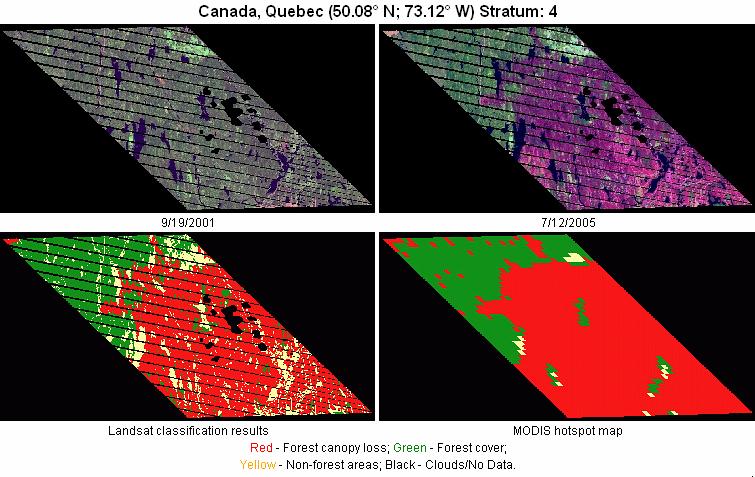
19 Landsat sample blocks analysis Boreal biome Image classification Change Classification results RED change GREEN forest mask


20 Landsat sample blocks analysis Boreal biome Image classification Change Classification results RED change GREEN forest mask MODIS results

21
22
23
24 Boreal biome 118 sample blocks MODIS-derived change estimates, % change area per sample block y = 1.14x R 2 = Landsat-derived change estimates, % change area per sample block

25 Landsat-calibrated forest cover and forest cover loss estimates for Boreal biome

26 Landsat-calibrated forest cover and forest cover loss estimates for Humid Tropical biome
27 MODIS change analysis validation using independent datasets NFDP burned areas data for Canada Comparison of annual burned area per province Annual area burned per province, thousand ha. MODIS y = 0.61x R 2 = Annual area burned per province, thousand ha. NFDP
28 MODIS change analysis validation using independent datasets NFDP burned areas data for Canada Comparison of annual burned area for Canada NFDP MODIS 2500 Area burned, thousand ha
29 Forest cover loss area for continents and selected countries within the boreal biome Region By continent By country Percent of total biome area Within-region forest cover loss as percent of land area (s.e.) Within-region forest cover loss as percent of year 2000 forest area Percent forest cover loss within the region attributed to fire North America (0.12) Eurasia (0.12) Canada (0.15) Russia (0.19) Biome total 1.63 (0.10)
30 Biome-wide forest cover loss area estimation, Boreal Humid Tropics Biome area, million ha 2, ,962.4 Forest area 2000, million ha % forest loss (standard error) 1.63 (0.10) 1.39 (0.08) Area of forest loss , million ha % Forest loss area of forest 2000 area excluding fire 2.36
31 Conclusion A monitoring strategy combining data from sensors at multiple temporal and spatial resolutions offers a feasible and cost-effective methodology to produce timely, precise and internally consistent estimates of biome-wide forest cover loss. Results of this analysis illustrate the regional and temporal variability of forest cover loss within the boreal biome and point the way forward for combining such information with available carbon stock data to improve carbon accounting
32 Next Steps Complete temperate and dry tropical biomes Investigate other possibilities Estimating tree cover gain 1990 to 2000 using AVHRR as a stratifier 2005 to 2010 continuation of present approach
Forest change detection in boreal regions using
 Forest change detection in boreal regions using MODIS data time series Peter Potapov, Matthew C. Hansen Geographic Information Science Center of Excellence, South Dakota State University Data from the
FORMA: Forest Monitoring for Action
 FORMA: Forest Monitoring for Action FORMA uses freely-available satellite data to generate rapidly-updated online maps of tropical forest clearing. We have designed it to provide useful information for
Towards Methodologies for Global Monitoring of Forest Cover with Coarse Resolution Data
 Towards Methodologies for Global Monitoring of Forest Cover with Coarse Resolution Data R. DeFries M. Hansen J. Townshend R. Sohlberg M. Carroll C. DiMicelli University of Maryland, College Park Objective:
Improvements in Landsat Pathfinder Methods for Monitoring Tropical Deforestation and Their Extension to Extra-tropical Areas
 Improvements in Landsat Pathfinder Methods for Monitoring Tropical Deforestation and Their Extension to Extra-tropical Areas PI: John R. G. Townshend Department of Geography (and Institute for Advanced
Linking Remote Sensing and Economics: Evaluating the Effectiveness of Protected Areas in Reducing Tropical Deforestation
 Linking Remote Sensing and Economics: Evaluating the Effectiveness of Protected Areas in Reducing Tropical Deforestation Joe Maher 1 and Xiaopeng Song 2 1 University of Maryland, Department of Agricultural
Accuracy assessment of the vegetation continuous field tree cover product using 3954 ground plots in the south-western USA
 International Journal of Remote Sensing Vol. 26, No. 12, 20 June 2005, 2699 2704 Accuracy assessment of the vegetation continuous field tree cover product using 3954 ground plots in the south-western USA
Overview of new MODIS and Landsat data derived products to characterise land cover and change over Russia. Sergey BARTALEV
 Russian Academy of Sciences Space Research Institute (IKI) Overview of new MODIS and Landsat data derived products to characterise land cover and change over Russia Sergey BARTALEV 15 Aprile 2013, GOFC-GOLD
Multi-sensor imaging of tree and water cover time-series at continental to global scales
 1 Multi-sensor imaging of tree and water cover time-series at continental to global scales Joe Sexton Min Feng, Saurabh Channan, John Townshend (PI) Global Land Cover Facility Department of Geographical
Performance anomalies are a relative measure of ecosystem services
 Performance anomalies are a relative measure of ecosystem services Bruce K. Wylie 1, J. Rover 2, and E. Fosnight 1 1 ASRC Research and Technology Solutions, contractor to the USGS at the EROS Center. Work
Remote sensing as a tool to detect and quantify vegetation properties in tropical forest-savanna transitions Edward Mitchard (University of Edinburgh)
") Remote sensing as a tool to detect and quantify vegetation properties in tropical forest-savanna transitions Edward Mitchard (University of Edinburgh) Presentation to Geography EUBAP 10 th Oct 2008 Supervisor:
Remote sensing as a tool to detect and quantify vegetation properties in tropical forest-savanna transitions Edward Mitchard (University of Edinburgh) Presentation to Geography EUBAP 10 th Oct 2008 Supervisor:
MULTI-ANGULAR SATELLITE REMOTE SENSING AND FOREST INVENTORY DATA FOR CARBON STOCK AND SINK CAPACITY IN THE EASTERN UNITED STATES FOREST ECOSYSTEMS
 MULTI-ANGULAR SATELLITE REMOTE SENSING AND FOREST INVENTORY DATA FOR CARBON STOCK AND SINK CAPACITY IN THE EASTERN UNITED STATES FOREST ECOSYSTEMS X. Liu, M. Kafatos, R. B. Gomez, H. Wolf Center for Earth
Humid tropical forest clearing from 2000 to 2005 quantified by using multitemporal and multiresolution remotely sensed data
 Humid tropical forest clearing from 2000 to 2005 quantified by using multitemporal and multiresolution remotely sensed data Matthew C. Hansen*, Stephen V. Stehman, Peter V. Potapov*, Thomas R. Loveland*,
Towards an operational MODIS continuous field of percent tree cover algorithm: examples using AVHRR and MODIS data
 Remote Sensing of Environment 83 (2002) 303 319 www.elsevier.com/locate/rse Towards an operational MODIS continuous field of percent tree cover algorithm: examples using AVHRR and MODIS data M.C. Hansen
Increasing the efficiency of forest clearing estimation in the Legal Amazon using targeted sampling
 Increasing the efficiency of forest clearing estimation in the Legal Amazon using targeted sampling Mark Broich 1 Stephen V. Stehman 2 Matthew C. Hansen 1 Peter Potapov 1 Yosio E. Shimabukuro 3 1 South
Fire Scar Detection in the Canadian Boreal Forest. Plummer, S.E., Gerard, F.F., Iliffe, L. and Wyatt, B.K.
 Fire Scar Detection in the Canadian Boreal Forest Plummer, S.E., Gerard, F.F., Iliffe, L. and Wyatt, B.K. Centre for Ecology and Hydrology, Monks Wood, Abbots Ripton, Cambs, PE17 2LS, UK Tel: +44 1487
Integration of forest inventories with remotely sensed data for biomass mapping: First results for tropical Africa
 Integration of forest inventories with remotely sensed data for biomass mapping: First results for tropical Africa Alessandro Baccini Nadine Laporte Scott J. Goetz Mindy Sun Wayne Walker Jared Stabach
Quantifying CO 2 fluxes of boreal forests in Northern Eurasia
 Quantifying CO 2 fluxes of boreal forests in Northern Eurasia Integrated analyses of in-situ eddy flux tower, remote sensing and biogeochemical model Xiangming Xiao Institute for the Study of Earth, Oceans
COMPARATIVE STUDY OF NDVI AND SAVI VEGETATION INDICES IN ANANTAPUR DISTRICT SEMI-ARID AREAS
 International Journal of Civil Engineering and Technology (IJCIET) Volume 8, Issue 4, April 2017, pp. 559 566 Article ID: IJCIET_08_04_063 Available online at http://www.iaeme.com/ijciet/issues.asp?jtype=ijciet&vtype=8&itype=4
Aboveground carbon loss in Democratic Republic of the Congo
 Jurisdictional Approaches to Green Development Jurisdictional-scale carbon accounting: evaluating options Aboveground carbon loss in Democratic Republic of the Congo Study and Presentation by: Alexandra
Forest Disturbances Requirements of Biomass Datasets
 CENTRE FOR LANDSCAPE AND CLIMATE RESEARCH Forest Disturbances Requirements of Biomass Datasets Heiko Balzter Pedro Rodriguez-Veiga 1 st ESA CCI Biomass Workshop, Paris, France 25-26 September 2018 Biomass
Mapping Hemlocks to Estimate Potential Canopy Gaps Following Hemlock Woolly Adelgid Infestations in the Southern Appalachian Mountains
 Mapping Hemlocks to Estimate Potential Canopy Gaps Following Hemlock Woolly Adelgid Infestations in the Southern Appalachian Mountains Tuula Kantola, Maria Tchakerian, Päivi Lyytikäinen-Saarenmaa, Robert
Supplementary Information
 Supplementary Information 585 590 595 600 605 The 46 sites that were used in this study represent gradients in climate, tree cover, and disturbance frequency (Figure 1; Table S3). The sites fall within
Remote Sensing Uses in Agriculture at NASS
 Remote Sensing Uses in Agriculture at NASS United States Department of Agriculture (USDA) National Agriculture Statistics Service (NASS) Research and Development Division Geospatial Information Branch
of ecosystems to climate change moderated by habitat intactness. Global Change Biology
 Felix Eigenbrod 1, Patrick Gonzalez 2, Jadunandan Dash 3, and Ilse Steyl 1. 2015. Vulnerability of ecosystems to climate change moderated by habitat intactness. Global Change Biology 21: 275-286. 1. Centre
Remote Measurements of Active Fire Behavior and Post-Fire Effects
 Remote Measurements of Active Fire Behavior and Post-Fire Effects Alistair Smith (and many many others ) Remote Sensing: A very Brief Overview ~ 5 million years B.C. : Humans Begin to Understand their
The Role of Land-Cover Change in High Latitude Ecosystems: Implications for the Global Carbon Cycle
 The Role of Land-Cover Change in High Latitude Ecosystems: Implications for the Global Carbon Cycle PI - A. David McGuire, University of Alaska Fairbanks Co-PIs Dave Verbyla, University of Alaska Fairbanks
The role of remote sensing in global forest assessments. Introduction, objectives and alternative survey scenarios
 The role of remote sensing in global forest assessments Erkki Tomppo 1 and Ray Czaplewski 2 1 Finnish Forest Research Institute, National Forest Inventory Unioninkatu 40 A, FIN-00170 Helsinki, Finland
Remote Sensing Techniques in Monitoring Post-Fire Effects and Patterns of Forest Recovery in Boreal Forest Regions: A Review
 Remote Sens. 2014, 6, 470-520; doi:10.3390/rs6010470 Review OPEN ACCESS remote sensing ISSN 2072-4292 www.mdpi.com/journal/remotesensing Remote Sensing Techniques in Monitoring Post-Fire Effects and Patterns
Mangrove deforestation analysis in Northwestern Madagascar Stage 1 - Analysis of historical deforestation
 Mangrove deforestation analysis in Northwestern Madagascar Stage 1 - Analysis of historical deforestation Frédérique Montfort, Clovis Grinand, Marie Nourtier March 2018 1. Context and study area : The
LSP: using AVHRR NDVI data and from 2003 using MODIS NBAR. Water Quality: using MSS and TM Landsat data and from 2001 using
 Land cover land use change effects on surface water quality: Integrated MODIS and SeaWiFS assessment of the Dnieper and Don River basins and their reservoirs Anatoly A. Gitelson, Wesley Moses & Daniela
The Global Land Cover Facility
 The Global Land Cover Facility REASoN Activities John Townshend, Principal Investigator Joseph JaJa, Co-Principal Investigator University of Maryland January 2004 The GLCF The GLCF research facility is
Supplement of Daily burned area and carbon emissions from boreal fires in Alaska
 Supplement of Biogeosciences, 12, 3579 3601, 2015 http://www.biogeosciences.net/12/3579/2015/ doi:10.5194/bg-12-3579-2015-supplement Author(s) 2015. CC Attribution 3.0 License. Supplement of Daily burned
Map accuracy assessment methodology and results for establishing Uganda s FRL
 Map accuracy assessment methodology and results for establishing Uganda s FRL 1 Table of Contents Acronyms... 4 1 Introduction... 5 2 Process and institutions involved... 5 3 Objectives of the map AA...
MODIS ,,, 2005, %, Vol. 30,No. 7 July,2008 RESOURCES SCIENCE : (2008) : ; :
 : ; :") 2008 7 RESOURCES SCIENCE Vol. 30,No. 7 July,2008 :1007-7588(2008) 07-1076 - 08 MODIS 1,2, 1,2, 3,4 (1., 100101 ; 2., 100049 ; 3., 100875 ; 4., 100875) :,,,, MOD09Q1 1 2,MOD09A1 6 MOD11A2,, NDVI NDSI LST
2008 7 RESOURCES SCIENCE Vol. 30,No. 7 July,2008 :1007-7588(2008) 07-1076 - 08 MODIS 1,2, 1,2, 3,4 (1., 100101 ; 2., 100049 ; 3., 100875 ; 4., 100875) :,,,, MOD09Q1 1 2,MOD09A1 6 MOD11A2,, NDVI NDSI LST
Greening and Seasonality: Multi-scale Approaches
 Greening and Seasonality: Multi-scale Approaches Jiong Jia Chinese Academy of Sciences jiong@tea.ac.cn Yonghong Hu Hesong Wang Howie Epstein Skip Walker Rovaniemi, March 8, 2010 Available Data NOAA/AVHRR
A Decision Support Tool to Monitor Chimpanzee Habitat Health in Africa. Lilian Pintea 1, Samuel Jantz 2, Janet Nackoney 2, Matthew Hansen 2
 A Decision Support Tool to Monitor Chimpanzee Habitat Health in Africa Lilian Pintea 1, Samuel Jantz 2, Janet Nackoney 2, Matthew Hansen 2 1 the Jane Goodall Institute, Vienna, VA, USA 2 Department of
European Forest Fire Information System (EFFIS) - Rapid Damage Assessment: Appraisal of burnt area maps with MODIS data
 - Rapid Damage Assessment: Appraisal of burnt area maps with MODIS data") European Forest Fire Information System (EFFIS) - Rapid Damage Assessment: Appraisal of burnt area maps with MODIS data Paulo Barbosa European Commission, Joint Research Centre, Institute for Environment
European Forest Fire Information System (EFFIS) - Rapid Damage Assessment: Appraisal of burnt area maps with MODIS data Paulo Barbosa European Commission, Joint Research Centre, Institute for Environment
Estimating Soil Carbon Sequestration Potential: Regional Differences and Remote Sensing
 Estimating Soil Carbon Sequestration Potential: Regional Differences and Remote Sensing Tris West Environmental Sciences Division Technical Working Group on Agricultural Greenhouse Gases (T-AGG): Experts
NERIN-Fire activities (ongoing and future)
") NERIN-Fire activities (ongoing and future) T. Loboda 1, I. Csiszar 1, A. Terekhov 2, D. Ershov 3, E. Loupian 4,O. Ravsal 5 1 University of Maryland, USA; 2 Institute of Space Research, Kazakhstan; 3 Center
NERIN-Fire activities (ongoing and future) T. Loboda 1, I. Csiszar 1, A. Terekhov 2, D. Ershov 3, E. Loupian 4,O. Ravsal 5 1 University of Maryland, USA; 2 Institute of Space Research, Kazakhstan; 3 Center
Carbon in the Forest Biomass of Russia
 Carbon in the Forest Biomass of Russia Woods Hole Research Center R.A. Houghton Tom Stone Peter Schlesinger David Butman Oregon State University Olga Krankina Warren Cohen Thomas K. Maiersperger Doug Oetter
A North-American Forest Disturbance Record from Landsat Imagery
 GSFC Carbon Theme A North-American Forest Disturbance Record from Landsat Imagery Jeffrey Masek, NASA GSFC Forrest G. Hall, GSFC & UMBC Robert Wolfe, GSFC & Raytheon Warren Cohen, USFS Corvallis Eric Vermote,
ASSESSING THE STRUCTURE OF DEGRADED FOREST USING UAV
 ASSESSING THE STRUCTURE OF DEGRADED FOREST USING UAV STUDY CASE IN YUNGAS CLOUD FOREST, NORTH ARGENTINA Fernando Rossi 1, Andreas Fritz 2, Gero Becker 1, Barbara Koch 2 Albert-Ludwigs-Universität Freiburg
REMOTE SENSING OF EBVS TO MONITOR BIODIVERSITY. Andrew Skidmore, ITC, University Twente
 REMOTE SENSING OF EBVS TO MONITOR BIODIVERSITY Andrew Skidmore, ITC, University Twente INTRODUCTION BIODIVERSITY: THE VARIETY OF LIFE INTRODUCTION WHY BIODIVERSITY MATTERS: THE EXAMPLE OF ECOSYSTEM SERVICES
Global Biomass Map Products
 Global Biomass Map Products Maurizio Santoro (santoro@gamma-rs.ch) & GlobBiomass team Status of global biomass datasets at UW3 A first version of the global AGB and GSV datasets were delivered to ESA and
Satellite observations of fire-induced albedo changes and the associated radiative forcing: A comparison of boreal forest and tropical savanna
 Satellite observations of fire-induced albedo changes and the associated radiative forcing: A comparison of boreal forest and tropical savanna 1 Yufang Jin, 1 James T. Randerson, 2 David P. Roy, 1 Evan
MULTI-SOURCE SPECTRAL APPROACH FOR EARLY WATER-STRESS DETECTION IN ACTUAL FIELD IRRIGATED CROPS
 Department of Geography and Environmental Studies MULTI-SOURCE SPECTRAL APPROACH FOR EARLY WATER-STRESS DETECTION IN ACTUAL FIELD IRRIGATED CROPS Maria Polinova 1, Thomas Jarmer 2, Anna Brook 1 1 Spectroscopy
Canadian Forest Carbon Budgets at Multi-Scales:
 Canadian Forest Carbon Budgets at Multi-Scales: Dr. Changhui Peng, Uinversity of Quebec at Montreal Drs. Mike Apps and Werner Kurz, Canadian Forest Service Dr. Jing M. Chen, University of Toronto U of
County- Scale Carbon Estimation in NASA s Carbon Monitoring System
 County- Scale Carbon Estimation in NASA s Carbon Monitoring System Ralph Dubayah, University of Maryland 1. Motivation There is an urgent need to develop carbon monitoring capabilities at fine scales and
Remote Sensing of the Urban Heat Island Effect Across Biomes in the Continental USA
 Remote Sensing of the Urban Heat Island Effect Across Biomes in the Continental USA Marc Imhoff, Lahouari Bounoua, Ping Zhang, and Robert Wolfe NASA s Goddard Space Flight Center Land Cover Land Use Change
Identifying and and Understanding Carbon Cycle Implications of of North American Natural and and Anthropogenic Disturbances:
 Identifying and and Understanding Carbon Cycle Implications of of North American Natural and and Anthropogenic Disturbances: 1982-2005 Progress Progress Report Report NRA-04-OES-01 NRA-04-OES-01 Christopher
Forest Dragon 3 Project Id
 Forest Dragon 3 Project Id. 10666 Principle Investigator: Co-Investigator: Young Scientists: Prof. Li, Academy of Forest Sciences Prof. Schmullius, University of Jena Prof. Pang, Dr. Feilong, Dr. Santoro
Global Burnt Area Products
 Global Burnt Area Products Kevin Tansey Department of Geography, University of Leicester, UK kevin.tansey@le.ac.uk Structure Why burnt area estimation is important Challenges to global burnt area mapping
CARPE monitoring of the Congo Basin results and ideas for REDD monitoring
 CARPE monitoring of the Congo Basin results and ideas for REDD monitoring Matthew C. Hansen Erik Lindquist Peter Potapov Bwangoy Bankanza South Dakota State University Chris Justice Alice Altstatt Diane
Role and importance of Satellite data in the implementation of the COMIFAC Convergence Plan
 Plenary Meeting of the Congo Basin Forest Partnership (CBFP) Palais des Congrès, Yaoundé. Cameroon 11-12 November, 2009 Role and importance of Satellite data in the implementation of the COMIFAC Convergence
PeatRus project. Restoring Peatlands in Russia - for fire prevention and climate change mitigation
 PeatRus project Restoring Peatlands in Russia - for fire prevention and climate change mitigation Forest-peat fires 2010 9 August, 2010 Moscow, August 01, 2010 +36 C Gaps Inventory of peatlands Satellite
The GMES Forest Monitoring REDD Services Preparation of Sentinel 2 Applications
 Sentinel-2 for Science Workshop 21 May 2014, Frasacti The GMES Forest Monitoring REDD Services Preparation of Sentinel 2 Applications T. Haeusler, S.Gomez, G.Ramminger, R. Siwe Consortium led by: Project
Forestry Department Food and Agriculture Organization of the United Nations FRA 2000 GLOBAL FOREST COVER MAP. Rome, November 1999
 Forestry Department Food and Agriculture Organization of the United Nations FRA 2000 GLOBAL FOREST COVER MAP Rome, November 1999 Forest Resources Assessment Programme Working Paper 19 Rome 1999 The Forest
AUTOMATED LAND COVER MAPPING AND INDEPENDENT CHANGE DETECTION IN TROPICAL FOREST USING MULTI-TEMPORAL HIGH RESOLUTION DATA SET
 AUTOMATED LAND COVER MAPPING AND INDEPENDENT CHANGE DETECTION IN TROPICAL FOREST USING MULTI-TEMPORAL HIGH RESOLUTION DATA SET A. Verhegghen a, *, C. Ernst a, P. Defourny a, R. Beuchle b a Earth and Life
Everett A. Hinkley National Remote Sensing Program Manager
 USDA Forest Service Wildfire Support Programs Update GOFC-Fire IT Meeting October 2011 Everett A. Hinkley National Remote Sensing Program Manager USDA Forest Service / Geospatial Management Office Brad
SPACE MONITORING of SPRING CROPS in KAZAKHSTAN
 SPACE MONITORING of SPRING CROPS in KAZAKHSTAN N. Muratova, U. Sultangazin, A. Terekhov Space Research Institute, Shevchenko str., 15, Almaty, 050010, Kazakhstan, E-mail: nmuratova@mail.ru Abstract The
Forestry Department Food and Agriculture Organization of the United Nations FRA 2000 GLOBAL FOREST COVER MAPPING FINAL REPORT.
 Forestry Department Food and Agriculture Organization of the United Nations FRA 2000 GLOBAL FOREST COVER MAPPING FINAL REPORT Rome, 2001 Forest Resources Assessment Programme Working Paper 50 Rome 2001
Greenhouse Gas Emissions from Biomass Burning
 Global Fire Greenhouse Gas Emissions from Biomass Burning Chris Justice Geography Department Chris Justice GOFC/GOLD University Fire of Maryland IT co-chair University of Maryland Fires in Southern Africa,
New York Declaration on Forests
 Progress on the New York Declaration on Forests Technical Annexes Goal 1: At least halve the rate of loss of natural forests globally by 2020 and strive to end natural forest loss by 2030 November 2015
Remote Sensing for Fire Management
 Remote Sensing for Fire Management FOR 435/535: Remote Sensing for Fire Management 5. Severity A Source of Confusion Field Measures Remote Sensing Measures FOR 435: A Source of Confusion The terms fire
Combining models and data to quantify the terrestrial carbon cycle Shaun Quegan. ESA UNCLASSIFIED - For Official Use
 Combining models and data to quantify the terrestrial carbon cycle Shaun Quegan ESA UNCLASSIFIED - For Official Use Lecture content 1. What a C model has to do 2. Types of C models 3. Interfacing data
Product Delivery Report for K&C Phase 3. Maurizio Santoro. GAMMA Remote Sensing
 Product Delivery Report for K&C Phase 3 Maurizio Santoro GAMMA Remote Sensing Science Team meeting #21 Phase 3 Result Presentations Kyoto Research Park, Kyoto, Japan, December 3-4, 2014 Nuno Carvalhais,
Effects of Vegetation Dynamics on the relation between ET and soil moisture in the North American Monsoon region
 Effects of Vegetation Dynamics on the relation between ET and soil moisture in the North American Monsoon region Enrique R. Vivoni 1, Hernan A. Moreno 1, Giuseppe Mascaro 1, Julio C. Rodriguez 2, Christopher
Forest and Land Cover Monitoring by Remote Sensing Data Analysis
 Low Carbon Asia Research Network (LoCARNet) 3rd Annual Meeting Bogor, Indonesia November 24 26, 2014 Forest and Land Cover Monitoring by Remote Sensing Data Analysis Muhammad Ardiansyah Center for Climate
Using MODIS Medium-Resolution Remote Sensing Data to Monitor Hydroclimatic Variability
 Using MODIS Medium-Resolution Remote Sensing Data to Monitor Hydroclimatic Variability Past and Future Hydroclimatic Variability: Applications to water Resources Management in the Prairie Provinces, Canmore,
NASA DEVELOP National Program Focusing on Partnerships with project example
 National Aeronautics and Space Administration NASA Ames Research Center NASA DEVELOP National Program Focusing on Partnerships with project example Jenna Williams Center Lead Where DEVELOP Fits @ NASA
Forest Changes and Biomass Estimation
 Forest Changes and Biomass Estimation Project Title: Comparative Studies on Carbon Dynamics in Disturbed Forest Ecosystems: Eastern Russia and Northeastern China Supported by NASA Carbon Cycle Science
GLOBAL FOREST LAND- USE CHANGE FROM 1990 TO 2010: AN UPDATE TO A GLOBAL REMOTE SENSING SURVEY OF FORESTS
 Forest Resources Assessment Working Paper 187 GLOBAL FOREST LAND- USE CHANGE FROM 1990 TO 2010: AN UPDATE TO A GLOBAL REMOTE SENSING SURVEY OF FORESTS The designations employed and the presentation of
Assessment of North American Industrial Forests Disturbances, Biomass Extraction Growth Vigor
 Assessment of North American Industrial Forests Disturbances, Biomass Extraction Growth Vigor Chengquan Huang 1, Feng Aron Zhao 1, Xin Tao 1, Ming Feng 1, Pui-Yu Ling 1, Samuel Goward 1, Karen Schleeweis
Effects of Land Use On Climate and Water Resources: Application of a Land Surface Model for Land Use Management
 Effects of Land Use On Climate and Water Resources: Application of a Land Surface Model for Land Use Management Gordon Bonan, PI National Center for Atmospheric Research Boulder, Colorado Personnel Supported:
Globbiomass: new products and approaches
 Globbiomass: new products and approaches Global mapping of forest biomass: status-quo Maurizio Santoro 1, Oliver Cartus 1, GAMMA Remote Sensing Thuy Le Toan 2, Stephane Mermoz 2, Alexandre Bouvet 2, Ludovic
Different Methods To Estimate Above. Study From Nepal
 Different Methods To Estimate Above Ground dbiomass: A Comparative Study From Nepal A Comparative Study from Nepal Data Comparing 4 different methods to extrapolate LiDAR estimated carbon to landscape
Spatial patterns and estimates of global forest litterfall
 Spatial patterns and estimates of global forest litterfall GUANGRONG SHEN, 1,2, DONGMEI CHEN, 1 YU WU, 1 LU LIU, 1 AND CHUNJIANG LIU 1 School of Agriculture and Biology and Research Centre for Low-Carbon
Towards the Improvement of National Forest Monitoring Approaches
 Towards the Improvement of National Forest Monitoring Approaches Arief Wijaya Center for International Forestry Research (CIFOR), Indonesia Contributors: Ruandha Agung Sugardiman, Budiharto, Anna Tosiani,
APPLICATION OF NATIONAL FOREST INVENTORY FOR REMOTE SENSING CLASSIFICATION OF GROUND LICHEN IN NOTHERN SWEDEN. Sweden -
 ISPRS Archive Vol. XXXVIII, Part 4-8-2-W9, "Core Spatial Databases - Updating, Maintenance and Services from Theory to Practice", Haifa, Israel, 2010 APPLICATION OF NATIONAL FOREST INVENTORY FOR REMOTE
Testing the Global Surface Water Dataset for Canada
 Testing the Global Surface Water Dataset for Canada François Soulard Forum of Experts in SEEA Experimental Ecosystem Accounting 2018 Glen Cove, New York. June 2018 Global Surface Water (GSW) Produced by
Module 2.1 Monitoring activity data for forests using remote sensing
 Module 2.1 Monitoring activity data for forests using remote sensing Module developers: Frédéric Achard, European Commission (EC) Joint Research Centre (JRC) Jukka Miettinen, EC JRC Brice Mora, Wageningen
Satellite image classification of vegetation and surface water for assessment of flood damage to agricultural crops
 Satellite image classification of vegetation and surface water for assessment of flood damage to agricultural crops Lisa Colson 2, Mark Lindeman 1, Dath Mita 1, Tatiana Nawrocki 2, Paulette Sandene 1,
REGIONAL WORKSHOP ON REDD+ MRV IMPLEMENTATION AND DRIVERS OF DEFORESTATION
 REGIONAL WORKSHOP ON REDD+ MRV IMPLEMENTATION AND DRIVERS OF DEFORESTATION Guyana Forestry Commission Guyana, South America December, 2013 Outline of Presentation Background to MRV System Development Developing
September 8 th, 2018 Sample Current Affairs
 September 8 th, 2018 Sample Current Affairs 1. The latest study on global forest cover must be taken with a pinch of salt What are the key findings of study? What are the limitations of assessment of Forests?
Using Hansen's Global Forest Cover Change Datasets to Assess Forest Loss in Terrestrial Protected Areas
 Using Hansen's Global Forest Cover Change Datasets to Assess Forest Loss in Terrestrial Protected Areas A Case Study of the Philippines Armando Apan (Prof.), L.A. Suarez, Tek Maraseni & Allan Castillo
Opportunities and challenges for monitoring tropical deforestation and forest degradation in dynamic landscapes using Sentinel-2!
 Sentinel-2 For Science Workshop 20-22 May, 2014 ESA-ESRIN Frascati Opportunities and challenges for monitoring tropical deforestation and forest degradation in dynamic landscapes using Sentinel-2 Dirk
K&C Phase 4 Brief project essentials
 K&C Phase 4 Brief project essentials Measuring above-ground biomass and its changes over Brazilian tropical secondary forests and savanna woodlands (Cerrado) using L-band SAR data Shaun Quegan, João Carreiras
Quantifying the role of urban ecosystems on terrestrial carbon cycling
 Quantifying the role of urban ecosystems on terrestrial carbon cycling Cristina Milesi Cal State Univ Monterey Bay - NASA Ames Research Center Land transformed by urbanization is often the most fertile
Assessment of Irrigation Potential Utilization in Major Irrigation Project Using Geospatial Data
 Assessment of Irrigation Potential Utilization in Major Irrigation Project Using Geospatial Data Muthyam Shanker Abstract Many irrigation projects were constructed in India post-independence period spending
DEVELOPMENT OF A DECISION SUPPORT SYSTEM FOR NATURAL DAMAGE ASSESSMENT BASED ON REMOTE SENSING AND BIO-PHYSICAL MODELS
 DEVELOPMENT OF A DECISION SUPPORT SYSTEM FOR NATURAL DAMAGE ASSESSMENT BASED ON REMOTE SENSING AND BIO-PHYSICAL MODELS M.A. Sharifi a*, W.G.M. Bastiaanssen b, S.J. Zwart b a ITC, P.O. Box 6, 7500 AA, Enschede,
Remotely-Sensed Carbon and Water Variations in Natural and Converted Ecosystems with Time Series MODIS Data
 Remotely-Sensed Carbon and Water Variations in Natural and Converted Ecosystems with Time Series MODIS Data Alfredo Ramon Huete 1 Piyachat Ratana 1 Yosio Edemir Shimabukuro 2 1 University of Arizona Dept.
VEGETATION AND SOIL MOISTURE ASSESSMENTS BASED ON MODIS DATA TO SUPPORT REGIONAL DROUGHT MONITORING
 University of Szeged Faculty of Science and Informatics Department of Physical Geography and Geoinformatics http://www.geo.u-szeged.hu kovacsf@geo.u-szeged.hu Satellite products for drought monitoring
Evolution and Priorities for NASA Land Cover and Land Use Change Program
 Evolution and Priorities for NASA Land Cover and Land Use Change Program NASA LCLUC Science Team Meeting 15 th Anniversary University of Maryland 28 March 2011 Anthony C. Janetos, Director Joint Global
REMOTE SENSING, NORMALIZED DIFFERENCE VEGETATION INDEX (NDVI), AND CROP YIELD FORECASTING XIJIE LV THESIS
, AND CROP YIELD FORECASTING XIJIE LV THESIS") REMOTE SENSING, NORMALIZED DIFFERENCE VEGETATION INDEX (NDVI), AND CROP YIELD FORECASTING BY XIJIE LV THESIS Submitted in partial fulfillment of the requirements for the degree of Master of Science in
REMOTE SENSING, NORMALIZED DIFFERENCE VEGETATION INDEX (NDVI), AND CROP YIELD FORECASTING BY XIJIE LV THESIS Submitted in partial fulfillment of the requirements for the degree of Master of Science in
VEGETATION AND SOIL MOISTURE ASSESSMENTS BASED ON MODIS DATA TO SUPPORT REGIONAL DROUGHT MONITORING
 University of Szeged Faculty of Science and Informatics Department of Physical Geography and Geoinformatics http://www.geo.u-szeged.hu kovacsf@geo.u-szeged.hu Satellite products for drought monitoring
REDDAF. Infosheet. Content. Objective and Concept. November 2012
 November 2012 REDDAF Infosheet Content Objective and Concept Objective and Concept 1 User Requirements 2 Methods Development 2 Service Development 5 Validation and Proof of Concept 6 Capacity Building/Training
Canadian Wildland Fire Information System (CWFIS)
") The Canadian Wildland Fire Information System in support of the National Forest Carbon Accounting System and the National Sustainable Development Strategy NRCan Initiative Earth Science Sector (ESS) and
The Canadian Wildland Fire Information System in support of the National Forest Carbon Accounting System and the National Sustainable Development Strategy NRCan Initiative Earth Science Sector (ESS) and
Supporting Online Material for
 www.sciencemag.org/cgi/content/full/318/5853/1107/dc1 Supporting Online Material for Hurricane Katrina s Carbon Footprint on U.S. Gulf Coast Forests Jeffrey Q. Chambers,* Jeremy I. Fisher, Hongcheng Zeng,
A Remote Sensing Based Urban Tree Inventory for the Mississippi State University Campus
 A Remote Sensing Based Urban Tree Inventory for the Mississippi State University Campus W. H. Cooke III a and S.G. Lambert b a Geosciences Department, GeoResources Institute, Mississippi State University,
Assessing the use of LSA SAF VEGA data for environmental monitoring in Africa: Fractional cover and natural vegetation condition assessment
 Toulouse 16 November 21 LSA SAF 4 th user workshop 1 Assessing the use of LSA SAF VEGA data for environmental monitoring in Africa: Fractional cover and natural vegetation condition assessment J.-F. Pekel,