CDFW Compliance Guidance
|
|
|
- Edmund Black
- 6 years ago
- Views:
Transcription

1 CDFW Compliance Guidance David Manthorne Environmental Scien9st, CDFW Contact: Phone:
2 CDFW Compliance Guidance Outline 1. Cri9cal Species that Require Protec9on 2. Rural Land Use Impacts Associated with Development 3. CDFW s Jurisdic9on 4. Water Diversion: Surface Water, Springs, Wells 5. Water Storage: Ponds, Tanks 6. Stream Crossings: Culverts, Armored Fill Crossings 7. Viola9ons

3 Coho Salmon CA Threatened, Federally Endangered Species


4 Steelhead Trout Federally Threatened Species
5 Salmonid Habitat and Status Coho salmon and steelhead trout emerge from eggs laid in the gravel in the late winter and rear in the summer in cold tributary streams in our region Cool water temperatures and adequate instream flows are required for healthy rearing and overall success survival Pool and riffle habitat in streams should be connected to allow for food dri_ and dissolved oxygen content to promote survival Popula9ons con9nue to decline due to environmental degrada9on
6 Southern Torrent Salamander CA Species of Special Concern

7 Southern Torrent Salamander: Habitat Found in shallow, cold, clear, well- shaded streams, waterfalls and seepages, par9cularly those running through talus and under rocks all year Found in seeps and springs where people divert water Occasionally found in riparian vegeta9on adjacent to water, but usually found in contact with water

8 Why is this an Issue? Degraded Watershed Health Cannabis is an unregulated industry Water Diversion occurs from springs and tributary streams Grading causes erosion Headwater Amphibians at Risk Nutrients delivery causes algal blooms Explosion in rural residen9al development directly related to cannabis cul9va9on
9 Rural Land Development Requirements Development of a water source Road building Stream crossings Grading Permits required to conduct the work
")
10 CDFW s Authority CDFW has jurisdic9on over the conserva9on, protec9on, and management of fish, wildlife, na9ve plants, and habitat necessary for biologically sustainable popula9ons of those species (FGC 1802)
 that conserve the State s fish and wildlife public trust")
11 CDFW s Authority Responsible Agency California Endangered Species Act (CESA: FGC 2081) Fish and Game Code (FGC) that conserve the State s fish and wildlife public trust resources

 Water dra:ing/diversion Stream")

12 CDFW s Authority Responsible Agency Lake and Streambed Altera9on Agreement Program (LSAA: FGC 1600 et seq.) Water dra:ing/diversion Stream Crossings/Bridges Stream Crossings/Culverts Photo: JoAnn Dunn Photo: JoAnn Dunn
13 CDFW s Jurisdic9on Includes all streams with a bed, bank and channel that transport sediment Stream types include: Class I Fish bearing Class II Typically flow year round and support aqua9c life (ex. spring) Class III Intermijent flow, dries up in the summer and may not flow without recent rain Includes lakes, ponds and wet areas

14 Example: Class III Streams = Small Watershed, Small Channel
15 Water Diversion Permilng If you are diver9ng from a stream or a spring than it is most likely you need a permit from CDFW If you have a well that is near a stream than you may need a permit from CDFW, off- set wells are good If you are diver9ng from a pond, wetland, or wet area, then you need a permit from CDFW If you are diver9ng from loca9ons where fish or amphibians live, you will need to screen the intake with no greater than 3/32 inch material
16 Water Diversion Permilng What does it include? CDFW regulates water diversion by ensuring bypass flows are adequate past the Point of Diversion (POD) ex. 90% Based on the site specific loca9on of the POD s and the water needs/availability, CDFW is likely to assign a forbearance (no diversion) period in lieu of the applicant conduc9ng a bypass flow study To meet forbearance terms, water storage may be necessary and may come in the form of tanks or a pond Rate of diversion; slow is good

17 Water Diversion: Cistern is OK- Needs Cover

18 Water Diversion: Screened Intake OK

19 Water Diversion: Spring Excava9on Not OK = Viola9on
20 Water Use: Water Use and Storage Es9mated at 1.8 gallons per 10 square feet per day (WQ) Es9mated water need of 360 gallons per day for 2,000 square feet canopy Es9mate d water need of 1,080 gallons per day for 6,000 square feet of canopy Water Storage to Meet 150 Day Forbearance: ,000 gallons for 2,000 square feet 162,000 gallons for 6,000 square feet How to Store Water? Tanks, pond, reduce use
21 Pond Construc9on On- stream Ponds: - May be allowed with engineering, geologic review and proper permilng (CDFW, WQ, County) - Permit issuance is much slower and cost is higher - Ponds may not be lined on- stream Off- stream Ponds: - Allowed with proper permits (CDFW, County) - Must not promote erosion Loca9on - Shall not be located in a wetland

22 Pond Design Sizing - Pond should be sized to meet your water needs for storage of up to 180 days - Pond should be able to be drained should invasive bullfrogs be present to interrupt the life cycle Structural Integrity - Required to have an engineered spillway or overflow design - Must be designed by a licensed engineer


23 Pond Spillway Examples Pond spillway shall be armored to dissipate energy of concentrated flow Spillway shall be sized to accommodate the 100 year storm


24 Google Earth Documents Time of Construc9on

25 Good Loca9on for a Pond? Stable?

26 Spillway Constructed as Designed?

27 Cracked Fill Face is a Bad Sign

28 Water Diversion: Unpermijed On- stream Pond Not OK = Viola9on

29 No Spillway = Viola9on

30 Pond Built on Wetland = Viola9on

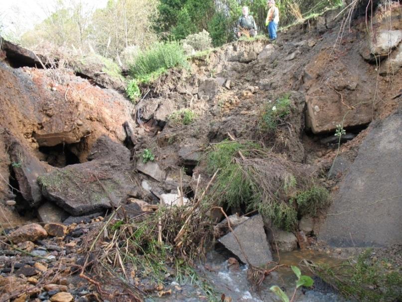
31 Pond is on stream = Viola9on

32 No Engineering = Viola9on

33 Pond Fail Built on Spring No Engineering, Expensive Liability

34 Stream Crossings: CDFW Permit Required
35 Stream Crossings Specifics: Culverts Culverts shall be sized to pass a 100- Year storm event and associated debris (ex. trees, branches) Culverts shall be set to grade, aligned with the natural stream channel, and extended beyond the fill slope (1-20 s9ck will not do in most cases) Rock armoring required around the culvert to dissipate energy and reduce erosion Consult with a professional

36 Example Stream Crossing: Steep Terrain with Downspout and Energy Dissipater = Good

37 Example: Armored Culvert = Good

38 Armored Fill Crossing: No Culvert = Good

39 Culvert: Shot- gunned, no armor = Failure

40 Culvert: No armor, grading near stream = Viola9on


41 Culvert Failure Can Destroy Your Road
42 CDFW Fish and Game Code Viola9ons Site Inspec9on 1602: Unpermijed altera9on of bed, bank, and channel (includes water diversion) 5650/5652: Pollu9on delivery to waters of the state 5937: Sufficient water for fish and amphibians below dam or POD 5901: To prevent or impede fish passage


43 Example: Pollutants near and in- stream diesel fuel for generators
44 CDFW Fish and Game Code Viola9ons CDFW is commijed to working with people who want to become compliant CDFW expects compliance to be achieved as expediently as possible Cul9va9on area will o_en dictate the expected speed of remedial ac9ons; the larger the canopy area, the faster we expect remedia9on It should be thought of as a business expense to protect the environment. Hire a consultant, they can help you

45 Contacts at CDFW Laurie Harnsberger: Administra9ve Staff David Manthorne: Environmental Scien9st
FORM B: DAMMING AND DIVERSION OF WATER
 APPLICATION FOR RESOURCE CONSENT FORM B: DAMMING AND DIVERSION OF WATER NOTES Resource use activities must meet all the conditions of any relevant Permitted Activity Rules in the Waikato Regional Plan
Application for resource consent Form B Damming and diversion of water
 Application for resource consent Form B Damming and diversion of water Notes Resource use activities must meet all the conditions of any relevant Permitted Activity Rules in the Waikato Regional Plan or
LEGAL AUTHORITY AND JURISDICTIONS
 CALIFORNIA DEPARTMENT OF FISH AND GAME RIPARIAN RESOURCES AND REGULATORS: The DFG Lake and Streambed Alteration 1600 Process LEGAL AUTHORITY AND JURISDICTIONS Serge Glushkoff CENTRAL COAST REGION YOUNTVILLE
Chehalis Basin Strategy Programmatic SEPA Draft EIS
 Chehalis Basin Strategy Programmatic SEPA Draft EIS History of Flooding I-5 closed in 1990, 1996, 2007, 2009 Five largest flood events occurred since 1986 2 History of Habitat Degradation Harvest has been
Case Study 12. Grubbs Concrete Slab Vented Ford
 Appendix A Case Study Case Study. Grubbs Concrete Slab Vented Ford Location North central California. Plumas National Forest. Mount Hough Ranger District. Grizzly Creek. 3 miles west of Bucks Lake, CA.
Western Strait Drainages. Watershed Summaries DRAINAGES EST WRIA 19 EST
 Page 31 WESTERN STRAIT DRAINAGES EST WRIA 19 WEST EST Snow, Bullman, Jansen & Olsen Creeks Sekiu River Hoko & Little Hoko Rivers Clallam River & Estuary Pysht River & Estuary Green Creek Jim & Joe Creeks
Cannabis Cultivation and the Protection of Public Resources
 Cannabis Cultivation and the Protection of Public Resources PRESENTATION FOR: FRESNO CANNABIS ASSOCIATION S FRESNO CANNABIS & HEMP CONFERENCE APRIL 26, 2017 Presented by: The Central Valley Regional Water
Case Study 15. Moonlight Crossing Concrete Box Vented Ford
 Appendix A Case Study 15 Case Study 15. Moonlight Crossing Concrete Box Vented Ford Location Northeastern California. Plumas National Forest. On Lights Creek, 8 miles north of Taylorsville, CA., Forest
Lyon Creek Cedar Way Stormwater Detention Dam Operation and Maintenance Manual
 Lyon Creek Cedar Way Stormwater Detention Dam Operation and Maintenance Manual Prepared by: Mike Shaw Stormwater Program Manager City of Mountlake Terrace January 2010 Section I General Information This
Central Strait Drainages DRAINAGES AST WRIA 19 AST
 Page 41 CENTRAL STRAIT DRAINAGES AST WRIA 19 EAST AST Deep Creek East Twin River E. Fork East Twin & Sadie Creek West Twin River Lake Crescent / Lyre River System Murdock Creek Field, Whiskey & Colville
Pacheco Reservoir Expansion
 California Water Commission Pacheco Reservoir Expansion Unique Opportunity for Fisheries Recovery, Flood Risk Reduction and Emergency Water Supply December 13, 2017 1 of 33 Project Partners Pacheco Pass
Chapter 3 Stream Discharge
 Chapter 3 Stream Discharge - Introductory Level Volunteer Water Quality Monitoring Training Notebook - What is Discharge (Flow)? Discharge, also called flow, is the amount of water that flows past a given
Response of Juvenile Salmonids to Habitat Restoration in Humboldt Bay, CA. Michael Wallace California Department of Fish and Game
 Response of Juvenile Salmonids to Habitat Restoration in Humboldt Bay, CA Michael Wallace California Department of Fish and Game What did the fish tell us about habitat needs and use? Coho Salmon Catches
Tokul Creek Intake Diversion Dam and Fishway Replacement
 University of Massachusetts Amherst ScholarWorks@UMass Amherst International Conference on Engineering and Ecohydrology for Fish Passage International Conference on Engineering and Ecohydrology for Fish
Case Study 5. Willow Creek Concrete Plank Ford
 Appendix A Case Study Case Study. Willow Creek Concrete Plank Ford Location Northeastern California. Plumas National Forest. Willow Creek. miles northwest of Portola, CA, on Spur Road 23N97Y off Forest
Environmental Assessment Form Part 1 Resource Identification Enclosure C Description of Aquatic Habitat
 Environmental Assessment Form Part 1 Resource Identification Enclosure C Description of Aquatic Habitat 8. Provide a written narrative, identified and labeled as Enclosure C Description of Aquatic Habitat,
Lagunitas Creek Stewardship Plan Marin Municipal Water District Final June 2011 TABLES
 Lagunitas Creek Stewardship Plan Marin Municipal Water District Final June 2011 TABLES Lagunitas Creek Stewardship Plan Final June 2011 Table 1: Chronology of events for the Marin Municipal Water District
Russian River Volunteer Drought Initiative Public Information Meeting. May 14 th, 2015 Salmon Creek School, Occidental
 Russian River Volunteer Drought Initiative Public Information Meeting May 14 th, 2015 Salmon Creek School, Occidental Agenda Why We re Here CDFW s Concern and Role Why These Watersheds Impacts on Streamflow
Atlantic Salmon ESA Listing Workshop
 Atlantic Salmon ESA Listing Workshop MARCH 26, 2010 Declining numbers of adults ESA Listing Overview When and why was the listing? 2000 Downeast rivers listing Other rivers added in June 2009 Prompted
SHORELINE INVENTORY AND RESTORATION PLANNING
 CHAPTER 3 SHORELINE INVENTORY AND RESTORATION PLANNING A. PURPOSE OF THE SHORELINE INVENTORY AND CHARACTERIZATION A first step in the comprehensive Master Program update process is development of a shoreline
STREAM INVENTORY REPORT PUDDING CREEK
 STREAM INVENTORY REPORT PUDDING CREEK WATERSHED OVERVIEW Pudding Creek is a tributary to the Pacific Ocean (Figure 1). Elevations range from sea level at the mouth of the creek to 1,600 feet in the headwater
INTERMEDIATE BMI ASSESSMENT TIER 2 FIELD SHEET
 INTERMEDIATE BMI ASSESSMENT TIER 2 FIELD SHEET PHYSICAL PARAMETERS ASSESSMENT FIELD SHEET ALL TIERS NAME: DATE: TIME: STREAM OR RIVER NAME: WATERSHED NAME: TOWN: WEATHER PRESENT PAST 48 HOURS SITE DESCRIPTION
4. Ponds and infiltration BMPs can achieve 60 to 100% removal efficiencies for sediment.
 Landscape BMPs For the purposes of this project, preventive measures have been categorized into two categories: landscape BMPs and source prevention BMPs. Landscape BMPs includes both vegetative practices
The F.O.R.C.E. The Future Of Redwood Creek Environment
 The F.O.R.C.E. The Future Of Redwood Creek Environment Robert Andersen Katelyn Csatari Achyuth Madabhushi Julie Swanson Overview Mission Statement Watershed Characterization Land and Water Use History
Farmington Dam Repurpose Project
 Farmington Dam Repurpose Project 2017 $158,100,000 to re-purpose the Farmington Dam from flood protection only to a long-term water storage facility that increases water supply reliability to the region.
Stream Health. Stream Bugs Our Stream Health Communicators. Upper Nottawasaga River Stream Health. NVCA Science & Stewardship
 NVCA Science & Stewardship Stream Health Upper Nottawasaga River, 2015 Stream Bugs Our Stream Health Communicators Stream bugs (benthic macroinvertebrates) are organisms that spend much or all of their
Suggested Stormwater Management Practices For Individual House Lots
 Suggested Stormwater Management Practices For Individual House Lots These practices are necessary to satisfy the water quantity and water quality criteria of the Rappahannock Stormwater Ordinance. These
Wood Canyon Emergent Wetland Project. City of Aliso Viejo 12 Journey, Suite 100 Aliso Viejo, CA 92656
 Wood Canyon Emergent Wetland Project City of Aliso Viejo 12 Journey, Suite 100 Aliso Viejo, CA 92656 Introduction Wood Canyon is located within Aliso and Wood Canyon Regional Park in southwest Orange County,
Climate Change and Fish in the Pacific Northwest: Case Study of the Snoqualmie River Basin
 Climate Change and Fish in the Pacific Northwest: Case Study of the Snoqualmie River Basin Pete Bisson USDA Forest Service PNW Research Station Olympia, WA U.S. Forest Service Water Strategy 2009-2019
DFO s Fish Habitat Management Program
 DFO s Fish Habitat Management Program Overview Fish and Fish Habitat DFO Policy - Objectives and Goals How Do the Fisheries Act and Navigable Waters Protection Act Affect Cattle Producers Riparian Areas,
Maitland Valley WATERSHED
 Maitland Valley WATERSHED Report Card 2018 Maitland Conservation has prepared this report card as a summary of the state of your forests, wetlands, and water resources. WHERE ARE WE? We are one of 36 Conservation
Glossary of Terms. Aquifer A permeable body of rock capable of yielding quantities of groundwater to wells and springs.
 Glossary of Terms 100-year flood A large, but infrequent, flood event that has a 1% chance of occurring in any given year (occurs, on average, once every 100 years). 100-year floodplain Areas adjacent
The Importance of Riparian Forests
 The Importance of Riparian Forests By Jean Llewellyn Monroe County is the second fastest growing county in Pennsylvania. This rapid growth can be problematic because uncontrolled and unregulated growth
Assessing Habitat in Watersheds. Sabrina Drill UC Cooperative Extension Los Angeles and Ventura
 Assessing Habitat in Watersheds Sabrina Drill UC Cooperative Extension Los Angeles and Ventura sldrill@ucdavis.edu 323-260 260-3404 What is Habitat? The environment in which a plant and animal lives, and
STREAM RESTORATION PURPOSE, PRACTICE, AND METHODS. By Marcus Rubenstein, CPESC
 STREAM RESTORATION PURPOSE, PRACTICE, AND METHODS By Marcus Rubenstein, CPESC WHAT IS STREAM RESTORATION? The return of a stream s lost natural functions, usually resulting from watershed alterations,
MONTEREY PENINSULA WATER MANAGEMENT DISTRICT PROJECT DESCRIPTION FOR SELECTIVE VEGETATION MANAGEMENT AND BANK RESTORATION (RANCHO SAN CARLOS AREA)
") MONTEREY PENINSULA WATER MANAGEMENT DISTRICT PROJECT DESCRIPTION FOR SELECTIVE VEGETATION MANAGEMENT AND BANK RESTORATION (RANCHO SAN CARLOS AREA) IN THE CARMEL RIVER CHANNEL, SUMMER AND FALL 2014 SELECTIVE
MONTEREY PENINSULA WATER MANAGEMENT DISTRICT PROJECT DESCRIPTION FOR SELECTIVE VEGETATION MANAGEMENT AND BANK RESTORATION (RANCHO SAN CARLOS AREA) IN THE CARMEL RIVER CHANNEL, SUMMER AND FALL 2014 SELECTIVE
Background. AEM Tier 2 Worksheet Stream & Floodplain Management. Glossary
 AEM Tier 2 Worksheet Stream & Floodplain Management Glossary Bankfull Stage: The stage at which water starts to flow over the flood plain; the elevation of the water surface at bankfull discharge. (This
2017 Agricultural Water Quality Workshop
 2017 Agricultural Water Quality Workshop Focus Area Lower Lewis and Clark Clatsop SWCD has identified this area as one that needs much improvement This does not mean we can t do projects in other areas
DECISION MEMO FOR CATEGORICAL EXCLUSION HOLY JIM CREEK CROSSING REPLACEMENT
 DECISION MEMO FOR CATEGORICAL EXCLUSION HOLY JIM CREEK CROSSING REPLACEMENT U.S.D.A. Forest Service Cleveland National Forest Trabuco Ranger District Orange County, California Background The current configuration
Maine s Land Use Regulations and Erosion Control Techniques
 Maine s Land Use Regulations and Erosion Control Techniques Protecting Maine s Air, Land and Water Colin Clark 441-7419 colin.a.clark@maine.gov Tom Gilbert 441-8031 thomas.gilbert@maine.gov Jim Rodrigue
APPENDIX D WATER DRAFTING GUIDELINES. D-1 NMFS Water Drafting Specifications. D-2 DFG Guidelines for Temporary Water Drafting: Preliminary Draft
 APPENDIX D WATER DRAFTING GUIDELINES D-1 NMFS Water Drafting Specifications D-2 DFG Guidelines for Temporary Water Drafting: D-1 NMFS - WATER DRAFTING WATER-DRAFTING SPECIFICATIONS National Marine Fish
The Science Behind Forest Riparian Protection in the Pacific Northwest States By George Ice, Summer 2004
 The Science Behind Forest Riparian Protection in the Pacific Northwest States By George Ice, Summer 2004 Riparian buffers, streamside management zones, and similar measures are essential parts of forest
Riparian Ecology Station OBJECTIVES
 Riparian Ecology Station OBJECTIVES Students learn The basic definition of a riparian area. The condition of any riparian area greatly affects the water quality and aquatic habitat of the water body it
RIPARIAN CORRIDOR STUDY FINAL CITY CREEK MANAGEMENT PLAN TABLE OF CONTENTS
 TABLE OF CONTENTS 1.0 INTRODUCTION... 1-1 Riparian Corridor Study and Management Plan Goals... 1-1 Study Area... 1-2 Importance and Functions of Riparian Corridors... 1-2 Habitat for Mammals, Birds, and
THE WATERSHED The watershed is an area of land that drains into a stream. This includes both the surface runoff and groundwater. Because a stream is m
 Understanding Streams A stream is the product of its watershed. Good land use in the watershed will be reflected in the stream. MOST PEOPLE enjoy the captivating qualities of flowing water. But streams
My Stream s Temperatures
 My Stream s Temperatures Temperature Adapted from: An original Creek Connections activity. Creek Connections, Box 10, Allegheny College, Meadville, Pennsylvania 16335. Grade Level: basic, all Duration:
Ponds. Pond A water impoundment made by excavating a pit, or constructing a dam or an embankment.
 POND SITE SELECTION AND CONSTRUCTION Uses, Planning, & Design David Krietemeyer Area Engineer USDA-NRCS June 20, 2008 Uses Considerations for Location of Commonly Used Terms Pond A water impoundment made
Assessing Fish Passage at Culverts the method, its metrics and preliminary findings from over 4,000 assessments.
 Assessing Fish Passage at Culverts the method, its metrics and preliminary findings from over 4,000 assessments. Richard Thompson, Ministry of Environment, Richard.Thompson@gov.bc.ca ABSTRACT There has
Appendix F. Response to Comments. North Coast System Rehabilitation Project 9/22/14 Phase 3 Coast Segment Draft Initial Study
 Appendix F This page intentionally left blank APPENDIX F RESPONSES TO COMMENTS In accordance with CEQA Guidelines Section 15073, the Initial Study/Draft Mitigated Negative Declaration (IS/MND) for the
No. 6 December, Wisconsin s Forestry Best Management Practices for Water Quality Forest Roads
 No. 6 December, 1995 Wisconsin s Forestry Best Management Practices for Water Quality Forest Roads Steve Holaday, Wisconsin Dept. of Natural Resources, and Jeff Martin, Dept. of Forestry, UW-Madison BMPs
Appendix A. Location of Transects, Study Sections, Instream Structures and U.S. Geological Survey Gage Stations -Russian River and Lower Dry Creek
 scanned for KRIS Appendix A Location of Transects, Study Sections, Instream Structures and U.S. Geological Survey Gage Stations -Russian River and Lower Dry Creek Symbols used are defined in the following
Fish Passage EXEMPTION Application
 OREGON DEPARTMENT OF FISH AND WILDLIFE Fish Passage EXEMPTION Application Use this form if a waiver has already been granted for the artificial obstruction for which an Exemption is being requested, fish
Habitat Assessment. Summary. Background. Chicago River Field Trip Activity
 Chicago River Field Trip Activity Summary Students answer a series of quantitative and qualitative questions to gage the quality of river and river edge habitat. Data can be used to interpret results from
Sandy Wyman Rangeland Management Specialist National Riparian Service Team SRM, Feb. 6, 2013
 Assessing Proper Functioning Condition (PFC) of Lentic Areas Sandy Wyman Rangeland Management Specialist National Riparian Service Team SRM, Feb. 6, 2013 TR 1737-16 What is PFC? How well physical processes
Temporary Stream Crossing
 Categories EC Erosion Control SE Sediment Control TC Tracking Control WE Wind Erosion Control Non-Stormwater NS Management Control Waste Management and WM Materials Pollution Control Legend: Primary Objective
TOWN OF SMYRNA Water Quality Buffer Zone Policy
 TOWN OF SMYRNA Water Quality Buffer Zone Policy Section I - Description A water quality buffer zone (a.k.a. a riparian zone) is a strip of undisturbed native (indigenous) vegetation, either original or
Temporary Stream Crossing
 Temporary Stream Crossing NS-4 Objectives EC Erosion Control SE Sediment Control TR Tracking Control WE Wind Erosion Control Non-Stormwater NS Management Control Waste Management and WM Materials Pollution
BIG ROCHE A CRI LAKE CHARACTERISTICS
 BIG ROCHE A CRI LAKE CHARACTERISTICS Lake Description Big Roche Cri Lake is located in north central Adams County and has a surface area of 205 acres, a shoreline length of 6.1 mile, a volume of 6,993
WASHINGTON WATER PROJECT CLEAR CREEK FISH PASSAGE AND INSTREAM FLOW ENHANCEMENT
 WASHINGTON WATER PROJECT CLEAR CREEK FISH PASSAGE AND INSTREAM FLOW ENHANCEMENT Final Narrative Report for Agreement 2014-04RR October 12, 2018 Please also view the project story map at: http://www.arcgis.com/home/item.html?id=22017a9e549142be8bb153fc0862c9b7
Battle Creek Salmon and Steelhead Restoration Project January 2017
 Battle Creek Salmon and Steelhead Restoration Project January 2017 Battle Creek has the unique geology, hydrology, and habitat suitability to support threatened and endangered Chinook salmon and Central
Missouri Streams. Fact Sheet. What factors affect stream habitat? Stream Habitat Affects Aquatic Communities
 Missouri Streams Fact Sheet Written by Del Lobb & Suzanne Femmer Edited by Sarah Wolken When most people think of habitat, they usually picture places where fish or wildlife live, like a hollow log or
Watershed Hydrology: Go with the flow. Greg Jennings, PhD, PE
 Watershed Hydrology: Go with the flow Greg Jennings, PhD, PE jenningsenv@gmail.com Streams What are your CHALLENGES? Hydrology too much water Pollutants upstream and on-site Vegetation wrong plants, wrong
EXECUTIVE SUMMARY. Consultative Committee Report Jordan River Water Use Plan
 EXECUTIVE SUMMARY The consultative process was initiated in April 2000 and completed in November 2001. The consultative process follows the steps outlined in the 1996 provincial government Water Use Plan
Funding Guidelines State Fiscal Year 2016
 State Fiscal Year 2016 Water Quality Financial Assistance Centennial Clean Water Program Clean Water Act Section 319 Program Stormwater Financial Assistance Program Washington State Water Pollution Control
3 Baseline and Existing Conditions
 1 2 3 4 5 6 7 8 9 10 11 12 13 14 3 Baseline and Existing Conditions The effective date of the VSP legislation is July 22, 2011. This is also the date chosen by the legislature as the applicable baseline
RIPARIAN CORRIDOR STUDY FINAL PARLEYS CREEK MANAGEMENT PLAN TABLE OF CONTENTS
 TABLE OF CONTENTS 1.0 INTRODUCTION... 1-1 Riparian Corridor Study and Management Plan Goals... 1-1 Study Area... 1-2 Importance and Functions of Riparian Corridors... 1-2 Habitat for Mammals, Birds, and
Ithaca Creek Habitat Monitoring
 Ithaca Creek Habitat Monitoring My name is: Class: Date: Ithaca Creek is part of the Catchment. Today when I was walking at the creek I decided that I wanted to investigate how healthy my waterway was.
Stream Crossing Reconstruction on the Bog Dam Loop Road (FR15) Scoping Notice. Androscoggin Ranger District
 Scoping Notice. Androscoggin Ranger District") United States Department of Agriculture Forest Service White Mountain National Forest Stream Crossing Reconstruction on the Bog Dam Loop Road (FR15) Scoping Notice Androscoggin Ranger District Androscoggin
United States Department of Agriculture Forest Service White Mountain National Forest Stream Crossing Reconstruction on the Bog Dam Loop Road (FR15) Scoping Notice Androscoggin Ranger District Androscoggin
WATERSHED. Maitland Valley. Report Card 201
 Maitland Valley WATERSHED Report Card 201 The Maitland Valley Conservation Authority has prepared this report card as a summary on the state of our forests, wetlands, surface water, and ground water resources.
7.0 WATER-BASED CONTROL MEASURES
 7.0 WATER-BASED CONTROL MEASURES 7.1 IDENTIFICATION AND DESCRIPTION OF CONTROL MEASURES Table 7-1 lists the water-based options being considered for implementation in the initial screening stage. Descriptions
Amphibian Protection Strategies. Presented by: Linda Dupuis, M.Sc., R.P.Bio Wildlife Habitat Ecologist
 Amphibian Protection Strategies Presented by: Linda Dupuis, M.Sc., R.P.Bio Wildlife Habitat Ecologist Vulnerability Biphase life histories and physiological limitations make aquatic-breeding amphibians
Kings Run Project Public Meeting. July 31, 2014
 Kings Run Project Public Meeting July 31, 2014 Welcome and Overview Lower Mill Creek - Kings Run Project Details Q&A Kings Run Project Stations (opportunity to talk to MSD staff) MSD is under a federal
SAN GERONIMO VALLEY SALMON ENHANCEMENT PLAN
 SAN GERONIMO VALLEY SALMON ENHANCEMENT PLAN A Guidance Document Prepared for Marin County Department of Public Works Prepared by Prunuske Chatham, Inc. with assistance from Stillwater Sciences February
TABLE OF CONTENTS. TOC-i
 TOC-i TABLE OF CONTENTS 1.0 INTRODUCTION... 1-1 Riparian Corridor Study and Management Plan Goals... 1-1 Study Area... 1-2 Importance and Functions of Riparian Corridors... 1-2 Habitat for Mammals, Birds,
WATER RESOURCES PAGE. Groundwater
 WATER RESOURCES PAGE Water Resources Water resources consist of two main sources of water: surface water and groundwater. Surface water is water in a river, lake or fresh water wetland. Surface water is
The Impacts of Cannabis Cultivation on Fisheries Recovery
 + The Impacts of Cannabis Cultivation on Fisheries Recovery A Concurrent Session at the 34 th Annual Salmonid Restoration Conference held in Fortuna, CA from April 6-9, 2016. + Session Overview Session
Project sponsors provided a brief presentation on their project(s), followed by comments from the Committee.
, followed by comments from the Committee.") WRIA 14 Salmon Habitat Recovery Committee Meeting April 17, 2014 Summary notes Project sponsors provided a brief presentation on their project(s), followed by comments from the Committee. Allyn Shoreline
WRIA 14 Salmon Habitat Recovery Committee Meeting April 17, 2014 Summary notes Project sponsors provided a brief presentation on their project(s), followed by comments from the Committee. Allyn Shoreline
Rainfall, runoff and sediment transport in the Napa River watershed: now and a possible future
 Rainfall, runoff and sediment transport in the Napa River watershed: now and a possible future Lester McKee San Francisco Estuary Institute 5/24/2017 1 The importance of the natural water cycle of infiltration
ILLINOIS URBAN MANUAL PRACTICE STANDARD TEMPORARY STREAM CROSSING (no.) CODE 975. Source: Hey and Associates, Inc.
 CODE 975. Source: Hey and Associates, Inc.") ILLINOIS URBAN MANUAL PRACTICE STANDARD TEMPORARY STREAM CROSSING (no.) CODE 975 Source: Hey and Associates, Inc. DEFINITION A bridge or culvert crossing installed across a stream or watercourse for short-term
ILLINOIS URBAN MANUAL PRACTICE STANDARD TEMPORARY STREAM CROSSING (no.) CODE 975 Source: Hey and Associates, Inc. DEFINITION A bridge or culvert crossing installed across a stream or watercourse for short-term
Information for File # PRH
 Information for File # 2016-02602-PRH Applicant Corps Contact Tom Morley Paul Hauser Address 152 Baker Drive, Redwood Falls, MN 56283 E-Mail Paul.R.Hauser@usace.army.mil Phone 651-290-5357 Primary County
Sustainable Natural Environment Fish Habitat
 Town of Huntsville Official Plan Review - POLICY BACKGROUND PAPER Sustainable Natural Environment Fish Habitat BACKGROUND: Lakes, rivers, streams, ponds and many wetlands provide fish habitat. Intermittent
Whatcom County Code Chapter Critical Areas Regulations: Wetlands, Streams, and Wildlife
 Whatcom County Code Chapter 16.16 Critical Areas Regulations: Wetlands, Streams, and Wildlife August 20, 2014 Wayne Fitch Natural Resources Supervisor Erin Page Natural Resources Planner III CAO Basics
Yakima Tributary Access & Habitat Program Summary of Accomplishments Diversion 14 Fish Passage and Screening, 2003 Ahtanum Creek
 Yakima Tributary Access & Habitat Program Summary of Accomplishments Diversion 14 Fish Passage and Screening, 2003 Ahtanum Creek This early action project involved removing a fish passage barrier, screening
Chapter Four: Overview. Introduction to Environmental Geology, 5e. Case History: Endangered Trout. Ecology and Geology Linkage
 Chapter Four: Overview Introduction to Environmental Geology, 5e Chapter 4 Ecology and Geology Jennifer Barson Spokane Falls Community College Linkages between geology with ecology and relationships with
TEMPORARY STREAM DIVERSION
 ILLINOIS URBAN MANUAL PRACTICE STANDARD TEMPORARY STREAM DIVERSION (ft,) CODE 976 (Source: Aukland Regional Council Stream Facts) DEFINITION A temporary channel or pipe used to convey stream flow around
COTTON CREEK CULVERT REPLACMENT
 COTTON CREEK CULVERT REPLACMENT Integrating Mobility with Environmental Innovation Located along a scenic section of Highway 3/95 in British Columbia, Moyie Bluffs, a 6.5 km stretch of inland highway had
Grand Traverse Bay Watershed Protection Plan:
 Grand Traverse Bay Watershed Protection Plan: An Overview Sarah U Ren Program Director The Watershed Center 231-935-1514, suren@gtbay.org The Grand Traverse Bay Watershed 973 square miles Bay Volume =
Watershed Response to Water Storage. 8/1/2012 Paul Wymar Scientist Chippewa River Watershed Project
 Watershed Response to Water Storage 8/1/2012 Paul Wymar Scientist Chippewa River Watershed Project Chippewa River Watershed 1.3 Million Acres Largest tributary watershed in the Minnesota River Basin 7
GRAYS HARBOR ESTUARY MANAGEMENT UNIT GRAYS HARBOR ESTUARY
 GRAYS HARBOR ESTUARY MANAGEMENT UNIT GRAYS HARBOR ESTUARY Description: The Grays Harbor Estuary is a bar-built estuary that was formed by the combined processes of sedimentation and erosion caused by both
United States Department of the Interior
 United States Department of the Interior FISH AND WILDLIFE SERVICE Red Bluff Fish & Wildlife Office 10950 Tyler Road, Red Bluff, California 96080 (530) 527-3043, FAX (530) 529-0292 July 20, 2015 To: Guy
Voluntary Water Quality Conservation Plan
 Voluntary Water Quality Conservation Plan Plan Table of Contents A. Mid Coast Agricultural Water Quality Management Area Rules and Plan Overview B. Landowner Resource/Practice Inventory C. Recommended
Oregon Water Resources Department
 Oregon Water Resources Department Final Order to Deny Limited License Application LL-1533 Appeal Rights This is a final order in other than a contested case. This order is subject to judicial review under
Water intake for hatchery on Chattahoochee River
 Lake Lanier Turnover Facts Buford Trout Hatchery gets the water used to grow trout from the tailwater area of the Chattahoochee River immediately below Lake Lanier. Natural processes occurring in the lake
Grand Traverse Bay Watershed Protection Plan:
 Grand Traverse Bay Watershed Protection Plan: An Overview Sarah U Ren Program Director The Watershed Center 231-935-1514, suren@gtbay.org What is a Watershed? A watershed is an area of land that captures
4. Present Activities and Roles
 4. Present Activities and Roles The present missions, authorities, activities and roles of the various agencies involved with flood protection, floodplain management and flood-damage reduction are identified
Carp Creek 2013 Summary Report
 Monitoring Activity in the Carp River Watershed In 2012, Mississippi Valley Conservation Authority (MVCA) worked with Friends of the Carp River (FCR) on a preliminary assessment of the Carp River. This
SMALL WATER PROJECTS PROGRAM 101 BY. JODIE PAVLICA, P.E. SMALL WATER PROGRAM MANAGER WYOMING WATER DEVELOPMENT OFFICE 3/20/18
 SMALL WATER PROJECTS PROGRAM 101 BY. JODIE PAVLICA, P.E. SMALL WATER PROGRAM MANAGER WYOMING WATER DEVELOPMENT OFFICE 3/20/18 TODAY S TOPICS SMALL WATER PROJECT PROGRAM To provide grant funding for Small
PROJECT HIGHLIGHTS,
 PROJECT HIGHLIGHTS, 2012-003 935 linear feet of fence encompassing livestock pond 1 water tank, 2 water troughs, 3800 linear feet pipeline Project: 2012-003 Watershed: Tomales Bay, East Shore Practices:
NORTH COAST INTEGRATED REGIONAL WATER MANAGEMENT PLAN
 NORTH COAST INTEGRATED REGIONAL WATER MANAGEMENT PLAN Integrated Coastal Watershed Management Plan IMPLEMENTATION PROPOSAL, ROUND 2, STEP 2 ATTACHMENT 13: LETTERS OF SUPPORT OR OPPOSITION Integrated Regional
Improving the River Petteril Online Story Map featuring a case study in catchment management
 Improving the River Petteril Online Story Map featuring a case study in catchment management Summary The Improving the River Petteril story map presents a catchment management case study for the River