Draft General Plan Amendment of 2015 SB Year Flood Protection March 25, 2015
|
|
|
- Thomas Owen Hodge
- 6 years ago
- Views:
Transcription

1 City of Lathrop Comprehensive General Plan Draft General Plan Amendment of 2015 SB Year Flood Protection March 25, 2015
2 City of Lathrop Comprehensive General Plan Draft General Plan Amendment of 2015 SB Year Flood Protection March 25, 2015 Community Development Department CITY OF LATHROP 390 Towne Center Drive Lathrop, CA rwillis@ci.lathrop.ca.us
3 Table of Contents CHAPTER 1.0 INTRODUCTION City of Lathrop The 200-Year Flood Protection Challenge Lathrop General Plan Year Flood Requirements for Local Government General Plan Amendment Organization Agency Consultation and Review California Environmental Quality Act GPA Adoption The SB 5 Bills Senate Bill 5 (2007) Senate Bill 17 and Assembly Bill 5 (2007) Assembly Bill 162 (2007) Assembly Bill 70 (2007) CHAPTER 2.0 AMENDMENT TO THE SAFETY ELEMENT OF THE LATHROP GENERAL PLAN Introduction Proposed Amendment of Safety Element Flood Protection Provisions of Existing LGP Safety Element Explicit Amendments of Lathrop General Plan Flooding in the City of Lathrop San Joaquin River Hydrology and Flooding Flooding and Flood Protection History Flood Protection Facilities Upstream Reservoirs Federal Project Levees State Plan of Flood Control (SPFC) Levees Reclamation District Levees Reclamation District Reclamation District Reclamation District Flood Hazard Areas Flood Hazard Zones, National Flood Insurance Program Maps U.S. Army Corps of Engineers Flood Hazard Information CVFPB Designated Floodway Maps Levee Flood Protection Zones Areas Subject to Inundation in the Event of the Failure of Project or Nonproject Levees or Floodwalls Awareness Floodplain Mapping Program RD 17 Detailed 200-Year Floodplain Mapping Dam Failure Inundation Maps Exposure to Flooding: Population, Essential Facilities, Real Property, Planned Growth Population, Improvement Values Essential Facilities City of Lathrop General Plan, SB 5 Flood Protection Amendment of 2015 iii
4 2.6.3 Planned Development in Lathrop Emergency Response Other Non-Structural Flood Management Strategies Levee Maintenance Exposure Reduction Standards and Criteria Federal Emergency Management Agency (FEMA) United States Army Corps of Engineers (USACE) California Department of Water Resources (DWR) Central Valley Flood Protection Board (CVFPB) Governor s Office of Emergency Services Delta Protection Commission Delta Stewardship Council San Joaquin County San Joaquin Area Flood Control Agency (SJAFCA) San Joaquin County Flood Control and Water Conservation District Paradise Cut Bypass Flood Protection Goals, Policies and Objectives Legislative Requirements Policy Definitions: Flood Protection Goals and Policies Flood Protection Implementation Measures CHAPTER 3.0 CONSISTENCY WITH THE LATHROP GENERAL PLAN Consistency with the Community Development Element Consistency with the Resource Management Element Consistency with the Hazard Management Element SOURCES City of Lathrop General Plan, SB 5 Flood Protection Amendment of 2015 iv
5 1.1 City of Lathrop CHAPTER 1.0 INTRODUCTION The City of Lathrop is a general law city located in San Joaquin County, California; Lathrop had a 2014 population of 19,800. The City lies east and west of the San Joaquin River as it flows north into the Sacramento-San Joaquin Delta at Mossdale. Interstate 5 (I-5), Interstate 205 (I-205) and State Route 120 (SR 120) intersect within the City (Figures 1, 2 and 3). Lathrop was incorporated in 1989 and adopted an urban growth-oriented general plan in 1991; the Lathrop General Plan has been amended several times since adoption. The City is responsible for public safety, including policing and fire protection, as well as for water, wastewater, storm drainage and parks and recreation services. City public safety concerns include flood protection, floodplain management and emergency response in the event of flooding. These services are delivered in cooperation with a variety of federal, state and local agencies. Locally, these agencies include the reclamation districts that are directly responsible for levee maintenance, Lathrop Police Services, the Lathrop-Manteca Fire District and San Joaquin County Office of Emergency Services. The various agency involvements are defined in more detail later in this document. 1.2 The 200-Year Flood Protection Challenge In 2007, the State of California approved Senate Bill 5 (2007) and a series of related Senate and Assembly bills intended to set new flood protection standards for urban areas. This group of bills, described in more detail in Section 1.9, is referred to collectively in this document as the SB 5 Bills. The SB 5 Bills establish the State standard for flood protection in urban areas as protection from the 200-year frequency flood. Under the SB 5 Bills, urban and urbanizing areas must be provided with 200-year flood protection no later than After July 2, 2016, new development in areas potentially exposed to 200-year flooding more than three feet deep will be prohibited unless the local land use agency certifies that 200-year flood protection has been provided, or that adequate progress has been made toward provision of 200-year flood protection by These requirements are to be instituted in local general plans and zoning. Most of the City of Lathrop is exposed to potential flooding from the San Joaquin River, and from Old River and Paradise Cut, which surround Stewart Tract. Existing 100-year flood protection is provided to much of this area by levees certified by the Federal Emergency Management Agency (FEMA); the levees are maintained by three local reclamation districts (RDs): RD 17, RD 2062 and RD RDs 17 and together with the City of Lathrop - are responsible for providing flood protection to urban and urbanizing portions of Lathrop; RD 17 together with the City of Manteca is responsible for flood protection in portions of Manteca immediately adjacent to Lathrop. The cities are seeking protection from 200-year flooding for these areas. RD 2107 is not currently protected from the 100-year flood, does not include urban or urbanizing areas and is not seeking 200-year flood protection. City of Lathrop General Plan, SB 5 Flood Protection Amendment of
6 San Joaquin County _ ^ City of Lathrop Regional Location Map Figure 1
7 RD 17, the City of Lathrop and the City of Manteca are in the process of evaluating flooding risk, assessing the capability of the existing levee system to provide 200-year flood protection, and determining what improvements are needed in order to provide the required level of protection. RD 2062 is independently pursuing 200-year flood protection for Stewart Tract, initially for Phase 1 of the River Islands project, which is under construction. The City of Lathrop intends to be able to demonstrate adequate progress toward meeting the 200-year flooding requirements for urban and urbanizing areas in RDs 17 and 2062 on or before July 2, In addition to setting 200-year flood protection requirements for urban areas, the SB 5 Bills also established new and more comprehensive State flood protection policies and a public investment strategy for flood protection improvements. Generally led by the State Department of Water Resources (DWR), the flood protection effort involves a range of local, state and federal agencies. These agency roles are described in more detail in Section The 200-year flood protection requirements imposed by the SB 5 Bills are to be enforced through other requirements of the Bills; the 200-year flood protection requirements must be incorporated into local general plans by July 2, 2015, and into local zoning ordinances by July 2, Upon its adoption by the Lathrop City Council, this document fulfills the general plan amendment (GPA) requirement of the SB Bills and will serve as the basis of required amendments of the Lathrop zoning ordinance. 1.3 Lathrop General Plan The California Government Code et. seq. requires each city and county to adopt a general plan for the physical development of the county or city, and any land outside its boundaries which bears relation to its planning ( 65300). The general plan has been deemed by the California courts to be the jurisdiction s constitution for future development. The general plan describes the community s land use and development goals, policies, objectives and standards and the measures needed to implement the plan. The general plan includes seven required elements: Land Use, Circulation, Housing, Conservation, Open-Space, Safety and Noise. Implementation measures may include the means for providing street and utility infrastructure needed to support new development, how natural resources will be conserved, and how public health and safety will be protected. Most local government decisions related to development are required by law to be consistent with the General Plan. The general plan is to be comprehensive in its treatment of land use and related issues, and the multi-faceted plan must also be internally consistent. The City of Lathrop has adopted a comprehensive, long-term general plan that addresses the applicable Government Code requirements in a range of specialized elements adapted to local conditions. The City, incorporated in 1989, adopted the City of Lathrop Comprehensive General Plan (the LGP ) on December 17, The LGP includes the seven elements required by law. The LGP has been updated several times since adoption; the last major amendment of the LGP occurred in November 2004 in conjunction with the approval of the Central Lathrop Specific Plan; the last update of the Housing Element was completed in The LGP Land Use/Circulation Diagram is shown on Figure 2. City of Lathrop General Plan, SB 5 Flood Protection Amendment of


8
9 The LGP divides the City into three sub-plan areas as shown on Figure 2; most of the land within the three sub-plan areas contains or is intended for urban development. Sub-Plan Areas 1 and 2 are located east of the San Joaquin River, and are protected from San Joaquin River flooding by RD 17 levees. Virtually all of the undeveloped land area within Sub-Plan Areas 1 and 2 has been entitled for urban development through specific plan approvals. Sub-Plan Area 3 is the approximately 5,000-acre Stewart Tract, site of the approved River Islands planned urban development; most of Stewart Tract is protected from flooding by RD 2062 levees, and nearly all of the Tract was entitled for urban development in The non-urban southeastern portion of Stewart Tract receives flood protection from RD City Specific Plan approvals are shown on Figure 3. California general plans have since 1971 been required to include a Safety Element that addresses flooding, geologic hazards, emergency response and other public safety concern; the adopted Lathrop General Plan includes consideration of these concerns. However, the Hurricane Katrina disaster in 2005 intensified flood protection concerns and underscored the need for better planning and emergency response preparation at all levels of government. The SB 5 Bills outlined a more aggressive State flood protection agenda, established the 200-year flood protection standard and placed most of the responsibility for meeting the new standard, and for implementing new policy, on local government. The individual SB 5 Bills are described in more detail in Section 1.9. The LGP includes consideration of flood hazards associated with the San Joaquin River, Old River and Paradise Cut. The LGP defines flood hazards with respect to the FEMA 100-year floodplain standard, which is the basis for the National Flood Insurance Program (NFIP), and has until passage of the SB 5 Bills been the land use planning standard for the State and the nation. FEMA makes federal flood insurance available to development within areas subject to potential 100-Year and 500-Year flooding provided that local land use regulations for the area conform to federal standards. The City has been active in land use planning, public involvement and other activities required to conform to federal requirements. The new 200-year flooding requirements of the SB 5 Bills exceed the FEMA 100-year standards but are not presently addressed in the LGP. This general plan amendment incorporates the 200-year standards and other requirements of the SB 5 Bills into the LGP Year Flood Requirements for Local Government The State s overall long-term program for improving flood protection includes expanded availability of flood risk and planning information, establishment of flood protection and facility design standards, technical assistance to flood protection and land use agencies, and an enforcement system for the new requirements. A key feature of the State program is the Central Valley Flood Protection Plan (the CVFPP ), adopted by the Central Valley Flood Protection Board in 2012; the CVPPP, to be updated on a 5-year cycle, provides an overall understanding of flooding risk and exposure in the Central Valley, the general nature and adequacy of existing flood protection systems, and a statewide strategy for the allocation of available funding for flood protection improvements; the financing strategy is known as the Statewide System Investment Approach (SSIA). City of Lathrop General Plan, SB 5 Flood Protection Amendment of
10 5 ONRAMP BRIGGS MANILA 0 12 JULIE RIS PH TO FIFTH UP D CY ER LA N TLE CH 120 South Lathrop Southeast Stewart Tract City of Lathrop Specific Plan Areas Figure 3 PARK UP Cross Roads Industrial Park D AR NES TORO LATHROP HO W W GOLD EN VALLEY AD PA R QUEIR OLO MAN TH E Y MCKEE E GOLDEN SPIK FI EL D WHEAT River Islands LOUISE N O SEVENTH N RIEGER PECAN HO LLO N IS E CO HE JONQUIL H I J K L DERBY RT OPAL EY MANTH AVON N RL A 5 PATRICIA THOMSEN K LONG BARN FIFTH (PVT) PA R 5 D OLD HA SPARTAN LA N STEW A BOULDER Central Lathrop DGE CAMBRI Mossdale Village Specific Plans DE LIMA TE SL A TALC OLIVIN E MCKINLEY HARLA KLO N FREWERT Lathrop Gateway
11 The CVFPP is primarily concerned with State Plan of Flood Control (SPFC) facilities, which are shared federal/state facilities the State is obligated to cooperate in maintaining and improving. In defining the SSIA, DWR considered three principal approaches to flood protection: 1) repair or improvements to SPFC levees, 2) 200-year flood protection improvements in high-risk urban and urbanizing areas, and 3) integrated projects, such as setback levees that improve the flood system capacity while achieving other goals. The SSIA identified $13-17 billion in phased improvements, including 200-year flood levee improvements along the San Joaquin River and expanding flood flow capacity via the Paradise Cut project. The CVFPP identifies the need for more area-specific Regional Flood Management Plans. An RFMP has been drafted for the Lower San Joaquin River-South Delta area (SJAFCA, 2014). Another key requirement of the SB 5 Bills is that urban and urbanizing areas must be provided with an Urban Level of Flood Protection (ULOP). An urban area is defined as: a developed area in which there are 10,000 residents or more. An urbanizing area as a developed area or an area outside a developed area that is planned or anticipated to have 10,000 residents or more within the next 10 years. Levees that are intended to provide ULOP must conform to State-defined Urban Levee Design Criteria (ULDC). The incorporated area of the City of Lathrop, excluding RD 2107, is composed of areas considered urban or urbanizing. RDs 17 and 2062 have identified providing ULOP as their individual goals for Long-Term Level of Flood Protection. RD 2107 is not currently protected from the 100-year flood, does not include existing or planned urban areas and does not need to or intend to provide ULOP. After July 2, 2016, the City of Lathrop may not approve new urban development in potential 200-year floodplain areas where predicted flood depths would be 3 feet or more unless ULOP has been provided, or unless the City certifies, based on substantial evidence that adequate progress has been made toward provision of ULOP by Development includes certain development agreements, subdivision maps and development permits as described in Government Code (a), 65962(a) and (a). The City may, however, allow development on sites that will be exposed to shallow 200-year flooding (less than 3 feet deep). These requirements will be instituted in the Lathrop General Plan and zoning. 1.5 General Plan Amendment Organization The requirements of the SB 5 Bills must be incorporated into the LGP on or before July 2, 2015, and into the City s Zoning Code by July 2, This document, the GPA, describes the amendments to the LGP needed to reflect the requirements of the SB 5 Bills. The GPA is organized as follows: Chapter 1.0. Introduction provides an overview of the City of Lathrop, flood protection considerations, and the general requirements of the SB 5 Bills to be met in the GPA. Chapter 2.0 is the proposed Amendment of the Safety Element of the LGP; the proposed amendment includes: Background information describing areas subject to flooding, agency flood protection responsibilities, existing and planned flood protection improvements, and emergency response responsibilities with respect to flooding, City of Lathrop General Plan, SB 5 Flood Protection Amendment of
12 Goals, policies and implementation measures that address flood protection as required by the SB 5 Bills. Chapter 3.0 reviews the consistency between the GPA and the LGP, and the need for amendments to the LGP to maintain internal consistency. Appendices 1.6 Agency Consultation and Review Government Code 65352(a), which governs the preparation and amendment of general plans, includes general requirements for review of general plans and amendments prior to adoption but also mandatory consultation requirements for the amendment of Safety Elements as required by the SB 5 Bills. Documentation of the City s consultation and review efforts, comments submitted in response to these efforts, and the City s consideration of comments are shown in Appendix A. 1.7 California Environmental Quality Act The GPA is a project as defined in the California Environmental Quality Act (CEQA), and therefore its potential environmental effects must be considered before the GPA can be adopted. An Initial Study of potential environmental effects of the GPA was prepared; on the basis of the Initial Study, the City believes that a Negative Declaration should be adopted and will provide public notice of its intent to do so as required by CEQA. Prior to adoption of this GPA, after the required public and agency review of the GPA and the proposed Negative Declaration, and based on the recommendation of the Lathrop Planning Commission, the City Council will consider whether the GPA would or would not involve a significant effect on the environment, and consider adopting the Negative Declaration. 1.8 GPA Adoption The City of Lathrop will conduct public hearings with respect to the GPA before the Lathrop Planning and City Council in June and July, Hearings will be noticed in accordance with the requirements of Government Code and After consideration of public comment and adoption of the Negative Declaration, and after considering the Planning Commission s recommendations, the City Council will consider approving the GPA. 1.9 The SB 5 Bills The SB 5 Bills consist of five interrelated Assembly and Senate bills passed in 2007, and several other related bills passed between 2009 and Overall, the Bills set in motion the State s plan for improvement of flood protection statewide; they establish the 200-year flood protection standard and ensure that 200-year protection will be provided to all Central Valley urban and urbanizing areas as soon as possible but no later than 2025 by requiring the amendment of local general plans and zoning to institute the requirements. The Bills provide that adequate flood hazard information be available to all portions of the State, in particular the Central Valley, and especially areas protected by State Plan of Flood Control (SPFC) levees such as the City of Lathrop. City of Lathrop General Plan, SB 5 Flood Protection Amendment of
13 The primary SB 5 Bills consist of SB 5, AB 5 and SB 17, AB 70 and AB 162. The full text of each of the bills are shown in Appendix B, and the primary bills are summarized below. Some of the 200-year floodplain requirements are applicable to all cities and counties in the State; some are applicable only to agencies within the Sacramento-San Joaquin Valley, and others are applicable only to agencies within the Sacramento-San Joaquin Drainage District. The City of Lathrop is located, at least partially, within all of these geographic areas (see Figure 4) Senate Bill 5 (2007) SB 5 establishes the State flood protection standard for urban areas in Water Code 9602(i) as the Urban Level of Flood Protection (ULOP). ULOP is defined as the level of protection that is necessary to withstand flooding that has a 1-in-200 chance of occurring in any given year (i.e. 200-year flooding) using criteria consistent with, or developed by, the (Department of Water Resources). These criteria are described in the Department of Water Resources (DWR) publication Urban Level of Flood Protection Criteri a(2013), including by reference DWR s Urban Levee Design Criteria (2012). The 200-year flood protection standard is to be implemented by cities and counties through required amendments of their general plans and zoning codes. The amendments must establish goals, policies and implementation measures consistent with State flood protection standards. Upon the effective date of the zoning amendment, local governments are prohibited from approving urban development projects - including certain development agreements, subdivision maps and other permits as specified in Government Code (a)(3), 65962(a) or (a) - within defined flood hazard zones if ULOP is not in place, or alternatively unless the local government certifies based on substantial evidence that adequate progress has been made toward provision of ULOP by In addition, SB 5 requires revisions to the California Building Standards Code for areas subject to flooding. Each County is required to prepare flooding emergency response plans in collaboration with the incorporated cities within its boundaries. SB 17 and Assembly Bill 162 are companion bills that were signed into law at the same time as SB 5. The contents of these related bills are discussed below Senate Bill 17 and Assembly Bill 5 (2007) These bills rename the State Reclamation Board as the Central Valley Flood Protection Board (CVFPB), defines the transfer of responsibilities between the entities and sets the administrative requirements for the CVFPB. The DWR is directed to prepare a preliminary report on the status of the State Plan of Flood Control and to prepare and adopt a strategic flood protection plan. The status report is the State Plan of Flood Control Descriptive Document. Adopted in 2012, the strategic plan is known as the Central Valley Flood Protection Plan (CVFPP). The CVFPP is intended to guide more-detailed Regional Flood Management Plans, flooding provisions of local general plans and zoning, and local flood management and facility improvement plans. Likewise, these local plans must be consistent with the CVFPP. City of Lathrop General Plan, SB 5 Flood Protection Amendment of


14 80 UV 50 UV 89 UV UV 12 Cosumnes River Stockton Lathrop 205 Mokelumne River Bear Creek Littlejohns Creek Modesto UV 88 Stanislaus River UV 4 UV 120 Tuolumne River Tuolumne River UV 395 UV 120 Nevada California UV 99 San Joaquin River UV 152 Merced River Merced UV 140 Ash Slough Fresno River UV 41 San Joaquin River 5 Fresno UV 101 San Joaquin River Watershed Sacramento - San Joaquin Drainage District San Joaquin River Tributaries Map prepared by Peterson Brustad, Inc. 0 1 inch = 25 miles Miles CITY OF LATHROP GENERAL PLAN AMENDMENT San Joaquin River Watershed Bakersfield 50 miles FIGURE 4
15 1.9.3 Assembly Bill 162 (2007) AB 162 augments the SB 5 requirement that cities and counties amend their general plans to reflect State standards and strategies. AB 162 sets forth more specific requirements for amendment of the Land Use, Conservation, and Safety Elements of the general plan, including required content of the elements. In addition to the Government Code s requirements related to consultation with agencies during preparation and amendment of general plans, AB 162 requires specific consultations and reviews that must take place during the amendment of Safety Elements in response to the SB 5 Bills. These include a required review of the GPA by the CVFPB and a requirement that the local agency consider and document its response to CVFPB comments. AB 162 also contains specifications related to future Housing Element updates; no changes to the Lathrop Housing Element are proposed at this time Assembly Bill 70 (2007) AB 70 provides that the City may be liable for its contribution to flood damage costs from unreasonably approving new development in areas protected by SPFC facilities. City of Lathrop General Plan, SB 5 Flood Protection Amendment of
16 CHAPTER 2.0 AMENDMENT TO THE SAFETY ELEMENT OF THE LATHROP GENERAL PLAN 2.1 Introduction The City of Lathrop is a general law city incorporated in Most of the City is developed or planned for urban development and is at the same time potentially affected by 200-year flooding from the San Joaquin River and its distributaries. The City is responsible for public safety, including floodplain management and emergency response. The City is seeking to provide ULOP for urban and urbanizing areas by 2025, and to be able to certify that adequate progress toward this objective has been made by July 2, The City in conjunction with the City of Manteca and Reclamation Districts 17 and 2062 are actively evaluating flooding risks, the effectiveness and condition of existing levees, and levee improvements needed to provide ULOP. Lathrop s general plan the LGP needs to be amended to reflect the requirements of the SB 5 Bills. This amendment of the Safety Element of the LGP amendment has been prepared in accordance with the applicable requirements of the SB 5 Bills. After adoption of the GPA, the Lathrop Zoning Ordinance (Chapter 17 of the Lathrop Municipal Code) will be amended to conform to the amended LGP and to the requirements of the SB 5 Bills. The SB 5 Bills included detailed new Safety Element requirements related to flood protection, including requirements for inclusion of certain data and analysis, and for establishment of goals, policies and implementation measures that reflect statewide flood protection strategies and feasible implementation measures. These detailed requirements are described in GC 65302(g)(2) and shown below. As required by the SB 5 Bills, preparation of this GPA included consultation with specified agencies listed in Appendix A. This GPA is being circulated to agencies with interests in flood protection for review and comment, including a required referral to the Central Valley Flood Protection Board and to local flood protection agencies with direct responsibility for flood protection. The City of Lathrop will consider the recommendations of the agencies, and they will be reflected in the adopted version of the GPA. Consultation that has occurred to date is documented in Appendix A. 2.2 Proposed Amendment of Safety Element Flood Protection Provisions of Existing LGP Safety Element The LGP contains an existing Safety Element prepared in accordance with the requirements that preceded the SB 5 Bills. At the time of the last modification of the LGP, the general plan content requirements for Safety Elements were described as follows: City of Lathrop General Plan, SB 5 Flood Protection Amendment of
17 California Government Code 65302, General Plan Content Requirements GC 65302(g) Safety Element Content Requirements 65302(g)(2) The safety element, upon the next revision of the housing element on or after January 1, 2009, shall also do the following: (A) Identify information regarding flood hazards, including, but not limited to, the following: Flood hazard zones. As used in this subdivision, "flood hazard zone" means an area subject to flooding that is delineated as either a special hazard area or an area of moderate or minimal hazard on an official flood insurance rate map issued by the Federal Emergency Management Agency (FEMA). The identification of a flood hazard zone does not imply that areas outside the flood hazard zones or uses permitted within flood hazard zones will be free from flooding or flood damage. (i) (ii) National Flood Insurance Program maps published by FEMA. Information about flood hazards that is available from the United States Army Corps of Engineers. (iii) Designated floodway maps that are available from the Central Valley Flood Protection Board. (iv) Dam failure inundation maps prepared pursuant to Section that are available from the Office of Emergency Services. (v) Awareness Floodplain Mapping Program maps and 200-year flood plain maps that are or may be available from, or accepted by, the Department of Water Resources. (vi) Maps of levee protection zones. (vii) Areas subject to inundation in the event of the failure of project or nonproject levees or floodwalls. (viii) Historical data on flooding, including locally prepared maps of areas that are subject to flooding, areas that are vulnerable to flooding after wildfires, and sites that have been repeatedly damaged by flooding. (ix) Existing and planned development in flood hazard zones, including structures, roads, utilities, and essential public facilities. (x) Local, state, and federal agencies with responsibility for flood protection, including special districts and local offices of emergency services. (B) Establish a set of comprehensive goals, policies, and objectives based on the information identified pursuant to subparagraph (A), for the protection of the community from the unreasonable risks of flooding, including, but not limited to: (i) (ii) Avoiding or minimizing the risks of flooding to new development. Evaluating whether new development should be located in flood hazard zones, and identifying construction methods or other methods to minimize damage if new development is located in flood hazard zones. (iii) Maintaining the structural and operational integrity of essential public facilities during flooding. (iv) Locating, when feasible, new essential public facilities outside of flood hazard zones, including hospitals and health care facilities, emergency shelters, fire stations, emergency command centers, and emergency communications facilities or identifying construction methods or other methods to minimize damage if these facilities are located in flood hazard zones. (v) Establishing cooperative working relationships among public agencies with responsibility for flood protection. (C) Establish a set of feasible implementation measures designed to carry out the goals, policies, and objectives established pursuant to subparagraph (B). City of Lathrop General Plan, SB 5 Flood Protection Amendment of
18 65302(g)(1) A safety element for the protection of the community from any unreasonable risks associated with the effects of seismically induced surface rupture, ground shaking, ground failure, tsunami, seiche, and dam failure; slope instability leading to mudslides and landslides; subsidence; liquefaction; and other seismic hazards identified pursuant to Chapter 7.8 (commencing with Section 2690) of Division 2 of the Public Resources Code, and other geologic hazards known to the legislative body; flooding; and wildland and urban fires. The safety element shall include mapping of known seismic and other geologic hazards. It shall also address evacuation routes, military installations, peakload water supply requirements, and minimum road widths and clearances around structures, as those items relate to identified fire and geologic hazards. The LGP contains information, goals and policies related to Safety Element requirements in two locations: Part IV Community Development Element, Section D Water, Sewerage, Drainage and Flood Control beginning on page 4-D-6. Part VI Hazard Management Element, Section A Safety beginning on page 6-1. The discussion of flooding in Part IV provides that FEMA 100-year flood protection is already provided for Sub-Plan Areas #1 and #2 area east of the San Joaquin River as a result of developer-funded and FEMAaccredited improvements to the RD 17 levees. FEMA 100-year flood protection was at that time the accepted flood protection standard; 200-year flood protection was not required nor addressed. The LGP contains no goals or policies specifically related to the RD 17 area. This portion of the LGP also addresses flood exposure in the Stewart Tract (Sub-Plan Area #3); at the time of construction, levees protecting the Stewart Tract were designed to prevent only 50-year frequency flooding. The LGP acknowledges that floods exceeding the 50-year design criteria have occurred in both the RD 2062 and RD 2107 portions of Stewart Tract, including the floods of 1997, and that additional improvements would be needed to provide adequate flood protection for urban development. The LGP provides additional detail and policy guidance regarding improvements that would need to be made to provide 100-year FEMA flood protection to planned urban development in the River Islands project. FEMA-accredited 100-year levees protect areas currently undergoing urban development. Provision of urban flood protection to the RD 2107 portion of Stewart Tract is not addressed. Like the RD 17 area, 200-year flood protection is not addressed for any portion of the Stewart Tract. The Hazard Management Element provides very limited information related to flooding. Technical information, analysis, goals and policies are provided related to geologic, seismic, soils, criminal activity, urban fire, emergency response and evacuation as well as peak demands on infrastructure under evacuation conditions. This section references the potential for flooding from the failure of upstream dams or levee breaks, but detailed information related to flooding-from the San Joaquin River and the flooding-related information required by the SB 5 Bills is not provided here Explicit Amendments of Lathrop General Plan Upon the adoption of this GPA, portions of the existing LGP Community Development Element related to flooding are amended, more specifically, as follows: The third paragraph of LGP page 4-A-15 is amended to read as follows: City of Lathrop General Plan, SB 5 Flood Protection Amendment of
19 State Law requires that the Land Use Element of the General Plan provide also for the proposed general distribution and general location and extent of the uses of the land for... agriculture, natural resources, recreation and enjoyment of scenic beauty and solid and liquid waste disposal facilities. Areas subject to flooding must also be identified as part of the Land Use Element. In this regard, only lands within the Stewart Tract are within the 100 year flood plain. Most of the urban and urbanizing land within the City of Lathrop is exposed to potential 200-year flooding as defined in SB 5 and related legislation. Urbanized and urbanizing areas of potential flooding are protected by levees accredited by FEMA to provide 100-year flood protection. The City is currently working in cooperation with the reclamation districts to improve the flood protection levees to the 200-year standard established by the State in SB 5 and related legislation. A complete discussion and specific identification of areas potentially subject to flooding as identified by the Federal Emergency Management Agency (FEMA) and the California Department of Water Resources (DWR) is provided in the General Plan Amendment of 2015, SB Year Flood Protection, adopted by the City Council on July 2, Page 4-D-6, delete and Flood Control from the section title Surface Water Drainage and Flood Control. Page 4-D-6, delete from the beginning of paragraph 3 at The potential for flooding... to the end of the second paragraph on page 4-D-7... under the Specific Plan process. On page 4-D-7, Policy 2, delete first sentence after from meet Project levee Standards... to the end of sentence and replace with meet 200-year Urban Levee of Protection standards. On page 4-D-8, add new heading and text after Policy 9 as follows: Floodplain Management Additional information and provisions related to flooding are included in the Hazards Management Element, Section A Safety, of the Lathrop General Plan, beginning at page 6-1. The major portion of this information is included in a separate document entitled City of Lathrop Comprehensive General Plan, General Plan Amendment of 2015, SB Year Flood Protection as adopted by the Lathrop City Council on, On adoption, that made a part of the Safety Element of the Lathrop General Plan. On page 6-1, add the following title and text prior to the title: SEISMIC HAZARDS FLOODING HAZARDS The Hazard Management Element of the Lathrop General Plan is amended to include the technical information, analysis, goals, policies, objectives and implementation measures required by Government Code as described in a separate document entitled City of Lathrop Comprehensive General Plan, General Plan Amendment of 2015, SB Year Flood Protection as adopted by the Lathrop City Council on July 2, That document is hereby added to and made a part of the Safety Element of the Lathrop General Plan. City of Lathrop General Plan, SB 5 Flood Protection Amendment of
20 2.3 Flooding in the City of Lathrop San Joaquin River Hydrology and Flooding The City of Lathrop is adjacent to the mainstem San Joaquin River as well as portions of Old River and Paradise Cut as they flow from the San Joaquin River to and through the Sacramento-San Joaquin Delta. Upstream (south) of the City of Lathrop, the San Joaquin River collects runoff from all of the major rivers draining the 13,500-square mile San Joaquin Valley; the drainage area, excluding the Tulare Lake Basin, includes over 40% of the land area in California (Figure 4). The San Joaquin River and its distributaries are the primary source of flooding in Lathrop; each convey seasonally high flows, which can result from prolonged rainfall, snow melt and rain-on-snow events in the watershed. The Lathrop area, with the exception of the most western portion of Stewart Tract, is not subject to tidal flooding, although water surface elevations during high flows through the City can be influenced by the tides. High flows on the San Joaquin River that are derived from rainfall generally occur between November and April and are characterized by high peak flows of moderate duration. Snowmelt floods, on the other hand, normally occur later in the year, between April and June; high flows derived from snowmelt may be sustained for weeks and months. The quantity of flow reaching the Lathrop area under either high flow condition is moderated by upstream reservoirs operated by federal, state and local agencies for various purposes, primarily water supply but including flood protection. Local flood protection systems are primarily levee constructed and maintained to federal standards by RDs 17, 2062 and 2107 (Figure 5) under the authority of the State (SJAFCA, 2014). The San Joaquin River discharges an average of more than 3 million acre-feet of water annually. Historically, as recorded by the US Geological Survey at Vernalis, monthly average flows have ranged from less than 100 cubic feet per second (cfs) in the late summer of some years to sustained winter and spring flows of 40,000 cfs. The highest recorded flow on the San Joaquin River at Vernalis was 79,000 cfs in 1950, including estimated flows through failed levees; the river reached its maximum flood elevation in The Regional Flood Management Plan (RFMP) for the Lower San Joaquin River/Delta Region (SJAFCA, 2014) estimated 100-year frequency and 200-year frequency San Joaquin River flows in cfs at several locations in the Lathrop area. The 200-year flow estimates were later refined by PBI in their 2014 study for the City of Lathrop, as shown below: Location 100-year 200-year (RFMP/PBI) Upstream of Paradise Cut 68,106 81,305/78,330 Downstream of Paradise Cut 43,049 61,330/56,860 Mossdale Railroad Bridge 42,796 63,772/62,100 Upstream of Old River 42,792 63,757/62,080 Downstream of Old River 13,879 29,024/32,140 City of Lathrop General Plan, SB 5 Flood Protection Amendment of
21 RD 404 RD 524 French Camp Slough City of Stockton Middle River 5 RD 1 RD 544 San Joaquin River RD 17 Lathrop City Limits Lathrop Sphere of Influence RD 2089 OldRiver City of Lathrop RD 2062 City of Manteca Paradise Cut RD 1007 RD 2058 RD 2107 RD 2096 UV City of Tracy RD 2094 Lathrop City Limits Lathrop Sphere of Influence Sacramento - San Joaquin Drainage District Reclamation District Boundary Stream 5 RD 2095 San Joaquin River RD 2075 Map prepared by Peterson Brustad, Inc. 0 1 inch = 1.5 miles Miles CITY OF LATHROP GENERAL PLAN AMENDMENT Reclamation and Drainage District Boundaries FIGURE 5
22 DWR s Regional Flood Atlas (DWR, 2013) estimates the design capacity of the San Joaquin River for floodwater passage at 52,000 cfs south and upstream of the City of Lathrop, 37,000 cfs along the San Joaquin River through the City, and 15,000 and 30,000 cfs in upper and lower Paradise Cut, respectively Flooding and Flood Protection History According to the San Joaquin County General Plan (SJGP, 2009), floods in the San Joaquin Valley have been recorded for over 175 years. The County reports that the Great Flood of was followed by major floods in 1867, 1881, 1890, and that other major floods occurred in 1904, 1907, 1909, 1911 and One of these floods washed out the UPRR crossing of the San Joaquin River and cut the US 50 connection between Lathrop and the San Francisco Bay area (Gatto, Freeman, pers. comms.). These and other events led to establishment of the cooperative federal-state flood protection system in the early 1900s. Under this system, the federal government reconstructed existing private levees and constructed new levees to federal standards, including several projects in San Joaquin County. These include the 1966 Lower San Joaquin River and Tributaries Project, which includes all of the project levees protecting the City of Lathrop; these levees are the responsibility of RD 17, RD 2062 and RD Constructed by the federal government, the State s contribution was acceptance of maintenance responsibility for the levees in perpetuity. This responsibility was later assigned to the reclamation districts. Notwithstanding the development of project levees over time, according to the San Joaquin County General Plan, major damaging flood events occurred in 1950, 1955, 1958, the 1962/63 season, the 1968/69 season and four times since 1980, most recently in January The most recent floods were caused by regional-scale storms that produced very high runoff in the San Joaquin River basin. The 1997 flood was the result of a rain-on-snow event that caused extensive flooding along the San Joaquin River and in the Delta, including flooding from 27 levee failures along the San Joaquin River. The 1997 flooding inundated both RD 2107 and RD 2062 as a result of floodwater spill from RD 2107 to RD Long-time local residents and Planning Commissioners Bennie Gatto and Mac Freeman report that flooding in Lathrop was relatively rare after the floods of the early 1900s. Despite levee improvements initiated in 1922, RD 2062 was flooded in 1938 and again in with the failure of the San Joaquin River levee. Following City approval of the River Islands project in 2003, RD 2062 improved levees surrounding the River Islands Phase 1 area, approximately 900 acres in the eastern portion of Stewart Tract, which were accredited by FEMA in No portion of the Stewart Tract has been subject to flooding since that time. Substantial additional improvements to RD 2062 levees will be required to support planned urban development of the River Islands project; these improvements are in the federal permit process, as discussed in more detail below. High river flows during the winter of caused flooding from increased groundwater levels in the area between the San Joaquin River and I-5. In 1997, there were no failures of the RD 17 levees although high flows required sandbagging along the levee top (Gatto, Freeman, pers. comms.). The levees also sustained considerable seepage damage in 1997; RD 17 subsequently completed two phases of levee seepage improvements and restored FEMA accreditation. A third phase of RD 17 seepage improvements is planned and undergoing permit review by the USACE. City of Lathrop General Plan, SB 5 Flood Protection Amendment of
23 The flood history of RD 2107 is not well-documented, but the District did flood in the 1938, and 1997 events. As noted, the 1997 flooding of RD 2107 also resulted in the flooding of the Stewart Tract. Planned improvements to the River Islands levees will include measures to prevent overflow of RD 2107 floodwater to RD 2062 and provide an avenue for release of RD 2107 floodwater back to Paradise Cut. DWR s Regional Flood Atlas (DWR, 2013) contains a more detailed flood history of the Lower San Joaquin area as a whole as well as descriptions of individual events. The Lower San Joaquin River/Delta RFMP (SJAFCA, 2014) estimates average annual equivalent damages from floods in the Lower San Joaquin River basin at approximately $25 million annually; about 60% of the estimated amount is attributed to crop damage. 2.4 Flood Protection Facilities The role of federal agencies in providing flood protection, primarily through the USACE, has historically been to evaluate flood risk, develop federal design standards and to design and construct federallyauthorized flood control facilities such as reservoirs, bypasses and levees. The State has not historically had a major role in flood protection planning, standards development or construction projects. In its longterm partnership with the federal government, the State has assumed responsibility primarily for maintenance and inspection of levees and other flood protection facilities constructed by the federal government Upstream Reservoirs Primary existing flood protection facilities in City of Lathrop are the federal project and State Plan of Flood Control levees maintained and improved by the reclamation districts, as discussed below. Outside and upstream of the Lathrop area, however, potential flood flows in the River are mitigated to a greater or lesser extent by federal, state and local agencies responsible for operation of upstream reservoirs, as coordinated by the USACE. Federal reservoirs constructed and operated by the USACE are primarily flood control facilities with secondary water supply functions. The USDI Bureau of Reclamation facilities are primarily water supply projects that include some flood protection storage, or are operated to reduce flood flows, on an individual basis. Irrigation districts and municipalities operate yet other water supply reservoirs that provide some flood control benefits. Reservoir Name Waterway Managing Entities Camanche Reservoir Mokelumne River East Bay MUD New Hogan Reservoir Calaveras River USACE New Melones Reservoir Stanislaus River US Bureau of Reclamation, OID, SSJID New Don Pedro Reservoir Tuolumne River Modesto and Turlock IDs, City of San Francisco Lake McClure Merced River Merced Irrigation District Millerton Lake San Joaquin River US Bureau of Reclamation City of Lathrop General Plan, SB 5 Flood Protection Amendment of
24 The reservoirs are operated in accordance with USACE flood control rules that require, during the flood season, a portion of the storage space in the lake to be reserved for capturing flood flow peaks and then releasing them gradually. The required flood control space is adjusted to reflect seasonal precipitation, soil moisture, and snowpack and the runoff characteristics of each river basin. During major flood events, there is close coordination between State, federal, and local agencies to forecast weather and runoff conditions, manage and coordinate flood releases from the reservoir system, patrol and floodfight along the levee and bypass system, and operate the weirs, drainage pumps, and other flood control structures (CVFPB, 2012) Federal Project Levees Flood management facilities protecting the City of Lathrop consist of project levees along both sides of the San Joaquin River, and along the sections of Paradise Cut and Old River enclosing Stewart Tract. The levees are a portion of the San Joaquin River Flood Control System (SJRFCS), which includes levees on the San Joaquin River, adjacent reaches of its tributaries and distributaries, and bypasses such as Paradise Cut from Gravelly Ford in Fresno County to the southern Delta. According to the USACE, the SJRFCS was visionary when conceived in the early 1900s. The SJRFCS has supported the economic prosperity of the Central Valley and fostered more intensive land uses in areas such as Lathrop that remain physically vulnerable to flood risks. This area is also one of the fastest growing parts of California, with much of the urban growth planned to occur in flood prone areas (USACE, 2002). The SJRFCS was developed and originally constructed by the USACE and the Central Valley Flood Control Board (formerly The Reclamation Board). The location of the project levees is shown on Figure 6. In addition to the Project levees, there are two segments of non-project levees located in RDs 17 and These are described in the following discussion of facilities managed by each district individually State Plan of Flood Control (SPFC) Levees The project levee system is the result of long-term federal-state agreements under which the State commits to the maintenance of the federally-constructed levees; these are known as State Plan of Flood Control (SPFC) facilities. The SPFC by definition consists of the state and federal flood control works, lands, programs, plans, policies, conditions, and mode of maintenance and operations of the... flood control projects in the Sacramento River and San Joaquin River watersheds... for which the (state) has provided the assurances of nonfederal cooperation to the United States... Actual maintenance work is delegated by the State to the Local Maintaining Agencies (LMAs), which in the Lathrop area are the reclamation districts; the work is overseen and inspected by the State. The riverbank levees protecting the City of Lathrop are SPFC facilities, which are also project levees (Figure 6). The SPFC inventory is somewhat fluid as facilities added or modified; the current SPFC inventory is presented in the State Plan of Flood Control Descriptive Document (CVFMPP, 2010). City of Lathrop General Plan, SB 5 Flood Protection Amendment of
25 S an Joaq uin Riv er Lathrop City Limits Lathrop Sphere of Influence Lathrop City Limits Lathrop Sphere of Influence Fre nch Camp Slough SPFC Levee Non-SPFC Levee Stream City of Stockton M iddle River 5 Old Rive r City of Lathrop Paradise Cut City of Manteca UV City of Tracy 5 San Joaquin River Map prepared by Peterson Brustad, Inc. 0 1 inch = 1.5 miles Miles CITY OF LATHROP GENERAL PLAN AMENDMENT SPFC Levees FIGURE 6
26 Historically, reclamation district levees were funded by the benefitted landowners, but some financial support has been provided by the State subventions program administered by DWR. Even with assistance from the State, many of the RDs have struggled to maintain and improve levees (SJAFCA, 2014) Reclamation District Levees RD 17, RD 2062 and RD 2107 are directly responsible for flood protection levees in the City of Lathrop. The State accepted responsibility for maintenance and improvement of the federally-constructed project levee, which was delegated to reclamation districts, which are also known as Local Maintaining Agencies (LMAs). All land in the Lathrop incorporated area is located in one of the three districts. The reclamation districts were established in the 1800s and early 1900s to reclaim low-lying lands for agriculture. As urban development expanded into former agricultural areas, the levees were improved to higher standards as a part of USACE projects such as the Lower San Joaquin River and Tributaries Project; the Lathrop area levees were improved to modern standards as a part of this project, which was completed in Reclamation districts are special districts that are authorized and created under the California Water Code and governed in accordance with the Government Code by an elected local board, usually composed of major landowners. Operation and maintenance costs are covered by property taxes, but the costs of major improvements must be met with State and federal funding managed through cooperative agreements. AB 156 requires public agencies that maintain levees that protect more than 1,000 people, such as RD 17 and RD 2062, to adopt Flood Safety Plans and sign cooperative agreements with the City or County in order to receive State funds for Project Levee upgrades. These agreements and plans are in place for RD 17. RD 2062 and RD 2107 do not presently meet the 1,000-person threshold but will be subject to these requirements when the threshold is reached. The RDs have been proactively working on their Flood Safety Plans, which are nearly complete. Flood Safety Plans must be approved by the City Engineer Reclamation District 17 Those areas of the City of Lathrop located east of the San Joaquin River are protected from flooding by RD 17 levees. RD 17 is bounded on the west by the San Joaquin River, on the north by French Camp Slough and on the south by a dry land levee protecting the District from flood waters passing through Reclamation Districts 2094 and 2096; high ground defines the District boundary on the east. RD 17 levees also protect portions of the cities of Manteca and Stockton as well as nearby unincorporated areas (Figure 7). The overall population in RD 17 was estimated to be in excess of 43,000 residents in 2013 (RD 17, 2013). RD 17 was organized in 1863 when initial levee construction began. By 1930 RD 17 had developed a levee system considered adequate by the USACE, but the District was subject to levee failure and flooding in 1938, and again in USACE development of the Lower San Joaquin River and Tributaries Project from , and then further improvements to these project levees by land developers in the late 1980s led to FEMA 100-year accreditation of the RD 17 system in City of Lathrop General Plan, SB 5 Flood Protection Amendment of
27 Lathrop City Limits M iddle River San Joaquin River Fre nch Camp Slough 5 City of Stockton RD 17 Lathrop Sphere of Influence Old River City of Lathrop Paradise Cut City of Manteca UV City of Tracy 5 Current RD 17 Seepage Project RD 17 Levee Stream Map prepared by Peterson Brustad, Inc. 0 1 inch = 1.5 miles Miles CITY OF LATHROP GENERAL PLAN AMENDMENT Reclamation District 17 FIGURE 7
28 During the floods of 1997, the RD 17 levees did not fail but were subject to seepage damage. Two phases of seepage improvements since then have preserved RD 17 s FEMA accreditation. A permit application for a third phase of seepage improvements is under consideration by the USACE. The DWR completed detailed Urban Levee and Non-Urban Levee Evaluations (ULE, NULE) program as reported in the Urban Levees Evaluation Program, Regional Flood Atlas The ULEP considered general levee conditions, evaluated possible deficiencies and identified improvements needed to meet ULDC requirements. Evaluation factors included levee geometry, seepage, structural instability, erosion, settlement, penetrations, levee vegetation, rodent damage and encroachments. Based on this analysis, the RD 17 levees were classified as being of Higher Concern together with the western RD 2062 levees, and the RD 2107 levees. The levees surrounding River Islands Phase 1 are classified as being of Lower Concern, and the Stewart Tract levees along Paradise Cut are classified as being of Medium Concern. The Atlas identified seepage problems in all three levee systems as well as isolated areas of slope instability, erosion and other performance problems. The City of Lathrop, City of Manteca and RD 17 are developing a program for design, funding and improvement of the RD 17 levees, including the non-project levee, to meet the ULDC and provide ULOP. A $1.1 million technical evaluation of levee conditions, improvements needed to meet ULDC and a preliminary cost estimate for improvements was completed in 2014 (KSN, 2014) based on existing data, including the DWR ULEP studies and the 200-Year Freeboard Analysis and Floodplain Mapping within RD 17 (PBI, 2014). The evaluation found that there were no ULDC deficiencies in height, geometry or other physical characteristics. The primary concern with respect to meeting the ULDC is potential for underseepage. The primary proposed remediation is the installation of cutoff walls in the existing levees together with other relatively minor improvements to correct levee top width, acquire right-of-way and correct slope stability and existing penetration concerns. The total projected cost of improvements is approximately $168 million. The cities are moving forward with an additional $1.4 million program to complete levee evaluations, secure construction funding, and then design and construct necessary improvements Reclamation District 2062 RD 2062 Stewart Tract is responsible for flood protection for approximately 4,900 City acres located west of the San Joaquin River and north of the UPRR, which is the site of the River Islands planned urban development. Flood protection for the Stewart Tract as a whole is provided by project and SPFC levees along the banks of the San Joaquin River, Old River and Paradise Cut (Figure 8). RD 2062 was organized, and initial levee plans were approved, in The entirety of Stewart Tract, including the levee system, was annexed to the City of Lathrop and approved for urban development in In 2003 the River Islands planned urban community was approved. Stage 1 of the River Islands project is currently under development. This portion of the Stewart Tract is protected from 100-year flooding by FEMA-accredited levees constructed in 2005 and The Stage 1 area is mapped as Zone X (areas protected by levees) by the FEMA FIRMs. The remainder of Stewart Tract north of the UPRR, approximately 3,800 acres, is located within the FEMA 100-year floodplain, Zone AE. City of Lathrop General Plan, SB 5 Flood Protection Amendment of
29 5 Rive r Middle Lathrop City Limits Old River Paradise Cut RD 2062 Dryland Levee UPRR UV 120 Lathrop SOI 205 City of Tracy FEMA Non-Accredited Levee FEMA-Accredited Levee 200-Year Levee (+ FEMA-Accredited) Lathrop City Limits Lathrop Sphere of Influence Stream 5 San Joaquin River Map prepared by Peterson Brustad, Inc. 0 1 inch = 1 mile Miles CITY OF LATHROP GENERAL PLAN AMENDMENT Reclamation District 2062 FIGURE 8
30 The Stage 1 levee improvements included a ring levee constructed landward of the project levees along the waterways; the project levees were reconstructed landward of the waterside crown, and the area between the ring levees and reconstructed project levees was subsequently filled with levee material to create what are termed super-levees. Dry-land (interior) levees were constructed within the Tract to complete 100-year flood protection for Stage 1; the interior levees are non-project levees and provide ULOP. The Stage 1 levees were designed and constructed in accordance with DWR 200-year flooding standards and levee design criteria in effect in The adopted ULDC were not in place at the time. RD 2062 is completing a detailed engineering evaluation of the Stage 1 levees to confirm they comply with ULDC. The Draft Engineering Report indicates that the Stage 1 levees meet all applicable ULDC, including levee height, width, seepage and stability. Due to the unusual nature of the super-levees, there are minor variances from the exact ULDC requirements but none that affect the ability of the levees to provide ULOP. Once the ULDC analysis is complete and reviewed by the independent review board, the goal is for the City to be able to certify that existing levees provide ULOP for new development in the Stage 1 area. Existing project levees surround the western 3,800 acres of the River Islands project and provide 50- year flood protection appropriate to agricultural areas. The existing RD 2062 levees were also analyzed by the DWR Urban Levees Evaluation Program with respect to levee geometry, seepage, structural instability, erosion, settlement, penetrations, levee vegetation, rodent damage and encroachments. The Old River levees were classified as being of Higher Concern while the levees along Paradise Cut were classified as being of Medium Concern. DWR s Regional Flood Atlas (DWR 2013) reported the design and condition of RD 2062 levees protecting River Islands Stage 1 as being of Lower Concern. RD 2062 is planning and will improve the balance of the levees to provide ULOP for planned urban development; an application has been submitted to the USACE for approval of levee and related improvements within the USACE jurisdiction, including improvements that will prevent flooding of River Islands caused from a levee failure in the RD 2107 portion of Stewart Tract. The USACE prepared and released a Draft Environmental Impact Statement covering this work for public review in November Because these levees will be improved after July 2016, River Islands intends to submit a plan prior to that date illustrating how those levees will be able to meet Adequate Progress for an ultimate 200-year level of certification in Reclamation District 2107 RD 2107 encompasses the southernmost portion of the Stewart Tract, the area south of the Union Pacific Railroad and outside of the River Islands project area. RD 2107 is bounded on the southwest by Paradise Cut and on the east and southeast by the San Joaquin River (Figure 9). The majority of RD 2107 is agricultural land but also includes a sand and aggregate mine, the Dell Osso Farms event facility and other areas of non-urban residential and commercial development. The Dell Osso facility is located in the City of Lathrop. The I-5 / I-205 combined freeway passes through RD City of Lathrop General Plan, SB 5 Flood Protection Amendment of
31 5 Dryland Levee UV 120 Lathrop City Limits UPRR Lathrop City Limits Lathrop SOI Paradise Cut RD FEMA Non-Accredited Levee FEMA-Accredited Levee 200-Year Levee (+ FEMA-Accredited) Lathrop Sphere of Influence Lathrop City Limits San Joaquin River Stream Map prepared by Peterson Brustad, Inc. 0 1 inch = 2,000 ft 1,000 2,000 Feet CITY OF LATHROP GENERAL PLAN AMENDMENT Reclamation District 2107 FIGURE 9
32 RD 2107 is mapped as being within the FEMA floodplain, Zone AE. This area is protected from flooding by levees but not to either 100-year or urban 200-year standards. RD 2107 levees were also considered by the DWR Urban Levees Evaluation Program and were classified as being of Higher Concern. RD 2107 is not seeking to provide ULOP and is not involved in detailed levee evaluation. The flood history of RD 2107 is not as well documented, but the District was flooded in the 1938, and As noted, the 1997 flood also resulted in the flooding of the adjacent RD The River Islands Phase 2 flood protection project will include measures to prevent further RD 2062 flooding and provide an avenue for release of floodwaters entering RD 2107 to Paradise Cut. RD 2107 is not seeking to provide ULOP but will continue to maintain its levees at PL levels (SJAFCA, 2014). Like RD 17 and 2062, RD 2107 is responsible for floodfighting and coordination with other agencies in emergency response situations. 2.5 Flood Hazard Areas GC 65302(g) requires that the Safety Element include a range of information related to flooding, including flood hazard zones, FEMA National Flood Insurance Program maps, flood hazard information available from the USACE, CVFPB floodway maps, dam failure inundation maps, Awareness Floodplain Mapping, 200-year floodplain maps available from DWR, Levee Protection Flood Zone maps, and maps of areas potentially subject to flooding in the event of a failure of levees and floodwalls. There are information overlaps between several of the listed items, and in some cases the required information has been superseded by more recent and/or accurate information. Nonetheless, each of the listed items is addressed in the following subsections. The cities of Lathrop and Manteca, as a part of their program to provide ULOP for urban and urbanizing areas exposed to 200-year flooding, have developed local and more precise 200-year floodplain area and depth maps. These maps, a refinement of the FEMA 100-year and 500-year floodplain mapping, are the foundation for the cities efforts to plan and design levee improvements needed to provide ULOP Flood Hazard Zones, National Flood Insurance Program Maps A flood hazard zone is defined in SB 5 as: an area subject to flooding that is delineated as either a special hazard area or an area of moderate or minimal hazard on an official flood insurance rate map issued by the Federal Emergency Management Agency. Flood Insurance Rate Maps (FIRMs) for the City of Lathrop have been issued by the FEMA. Figure 10 shows those areas in Lathrop that are shown on the FIRMs as being subject to flood risk in the various FEMA classifications. FEMA floodplain mapping is also shown in the Regional Flood Atlas, Map 16. City of Lathrop General Plan, SB 5 Flood Protection Amendment of
33 Lathrop Sphere of Influence Fren Ca m ch Lathrop City Limits gh A Zone (SFHA) City of Stockton X (shaded) Zone X Zone Stream p Sl ou FEMA FIRM Zones M iddle River 5 S an Jo a r ve Pa ra d is ec Lathrop City Limits Ri City of Lathrop Lathrop Sphere of Influence quin Ol dr i v er City of Manteca ut V U City of Tracy 5 San Joaquin River Map prepared by Peterson Brustad, Inc. 1 inch = 1.5 miles Miles CITY OF LATHROP GENERAL PLAN AMENDMENT FEMA Flood Insurance Rate Map FIGURE 10
34 According to the FIRMS, the San Joaquin River, Old River, most of Stewart Tract, and Paradise Cut between the existing levees are located in Zone AE, 100-year floodplain areas where Base Flood Elevations have been determined. These are classified by FEMA as Special Flood Hazard Areas (SFHAs). Areas outside of the SFHAs are classified as areas of moderate or minimal hazard. As shown on the FIRMs, approximately 990 acres of RD 2062, and virtually all of the City of Lathrop east of the San Joaquin River is located in Zone X. Zone X areas are protected from the 100-year flood by FEMA-accredited levees; these are also areas that would be exposed to flooding in the event of levee failure and that would be subject to potential 500-year flooding hazards. Zone X areas are areas of moderate or minimal hazard as defined by AB 162. RD 17, RD 2062 and the City are seeking to provide ULOP for both reclamation districts. The Interstate 5 embankments and railroad embankments within the City are mapped as Other Areas that are outside the area subject to 500-year flooding U.S. Army Corps of Engineers Flood Hazard Information The USACE is responsible for preparing the Sacramento and San Joaquin River Basins Comprehensive Study (SSJRCS) after the floods of This SSJRCS (USACE, 2002) addressed the entire Central Valley flood control system, including 1) a post-1997 flood risk and damage assessment, 2) development of plans for flood control and environmental restoration, and 3) development of a hydrologic/hydraulic model of the entire system, including the operation of the existing reservoirs. Among other things, the SSJRCS included mapping of the 100-year floodplain and of the 200-year and 500- year floodplains; the information provided in these maps are largely coincident with the FEMA FIRMs and are superseded by the FEMA regulatory maps. More recent and locally-accurate 200-year floodplain maps have been developed for the cities of Lathrop and Manteca (PBI, 2013). The SSJRCS maps are posted and available for review on the DWR Best Available Mapping web site ( floodmgmt/lrafmo/fmb/fes/best_available_maps/) CVFPB Designated Floodway Maps Designated floodways are the primary non-structural flood management program employed by the State through the CVFPB (CVFMPP, 2010). Land use in designated floodways is managed to maintain flood passage capacity. Designated floodway maps that are available are posted on the CVFPB web site. Although the City of Lathrop is exposed to flooding risks, review of the web site, and followup contact with CVFPB staff (Thatch, pers. comm.), confirms that the CVFPB has not designated any floodways in or adjacent to the City of Lathrop Levee Flood Protection Zones Levee Flood Protection Zones (LFPZs) are theoretical areas that could be flooded in the event of levee failure in levee-protected areas. More specifically, the LFPZs describe areas that would be flooded to depths of three feet or more, or to depths of less than 3 feet, if the river water level contained by a Statefederal project or SPFC levee is at the top of the levee, and then released as a result of levee failure. These maps were developed by California DWR, as required by Water Code Section 9130, to estimate the maximum potential flooded area from levee failure. The LPFZ inundation areas in Lathrop are shown on City of Lathrop General Plan, SB 5 Flood Protection Amendment of
35 Figure 11. The LPFZ maps are shown on Map 3 of the LSJR/D Regional Flood Atlas (DWR 2013) and online at As noted by DWR, the LPFZ maps are not regulatory tools and may not describe all potential flooding hazards Areas Subject to Inundation in the Event of the Failure of Project or Non- Project Levees or Floodwalls. As discussed in the previous section, maximum potential flooding from failure of project levees is described by Levee Flood Protection Zones (LFPZs) discussed in the previous section. Areas subject to potential inundation as a result of levee failure of project levees are also described by the FEMA Flood Insurance Rate Maps and floodplain mapping in the USACE Sacramento-San Joaquin Rivers Comprehensive Study. These same maps also describe flooding that could result from failure of the nonproject RD 17 dryland levee (Walthall Slough Dryland Levee) Awareness Floodplain Mapping Program DWR established the Awareness Floodplain Mapping project to identify flood hazard areas that may not otherwise be mapped, e.g. under the FEMA National Flood Insurance Program (NFIP), and to provide communities with an additional tool for understanding potential flood hazards. The DWR Awareness Floodplain Maps (DWR, 2015) do not show any areas in or near the City of Lathrop that are potentially subject to flooding and that are not already shown on the FEMA FIRMs or other federal or state floodplain maps RD 17 Detailed 200-Year Floodplain Mapping The City of Lathrop, in conjunction with the adjacent City of Manteca, the reclamation districts and other flood protection and funding agencies are taking action toward providing an Urban Level of Flood Protection (ULOP), including protection from the 200-year flood, in potentially-inundated portions of both cities. As a part of this effort, the cities jointly funded an initial contract with consultants Peterson Brustad Inc. (PBI) to produce the 200-year Freeboard Analysis & Floodplain Mapping Within RD 17. This analysis produced 1) a refined version of available federal and state hydraulic modeling, 2) 200-year water surface profiles in the San Joaquin River, and 3) mapping of the 200-year floodplain area (and depth) for all areas protected by RD 17 levees. The analysis addressed a number of potential levee break points, including one or more points along the non-project Walthall Slough Dryland Levee. This initial effort was completed in May Mapping results are shown on Figure 12, which shows areas of 200-year flood inundation by depth. The cities have also developed a reconnaissance-level assessment of ULDC deficiencies based on existing information produced by RD 17 and DWR, and a programmatic cost estimate for the levee rehabilitation needed to meet ULDC. The assessment indicates that the existing levees are generally consistent with geometric criteria and other ULDC. The cost of correcting deficiencies is estimated at approximately $150 million, primarily installation of cutoff walls to prevent seepage through the levee (KSN, 2014). City of Lathrop General Plan, SB 5 Flood Protection Amendment of
36 S an Joaq uin Riv er Lathrop City Limits Lathrop Sphere of Influence Levee Flood Protection Zone Deep Fre nch Camp Slough Shallow Depth Unknown Lathrop Sphere of Influence Lathrop City Limits Stream City of Stockton M iddle River 5 Old R iver City of Lathrop Paradise Cut City of Manteca UV City of Tracy 5 San Joaquin River Map prepared by Peterson Brustad, Inc. 0 1 inch = 1.5 miles Miles CITY OF LATHROP GENERAL PLAN AMENDMENT DWR Levee Flood Protection Zones FIGURE 11
37 Lathrop City Limits Lathrop Sphere of Influence Note: Detailed 200-year flood mapping not prepared for RD 2062 or RD French CampSlou gh Mi ddle River City of Stockton Overbank flooding from French Camp Slough not included in analysis Littlejohns Creek San Joaquin River UV 99 Old River Paradise Cut RD 2062 City of Lathrop City of Manteca RD 2107 UV Limits of Flood Mapping Lathrop City Limits Lathrop Sphere of Influence RD 17 Levee 200-Year Floodplain Depth (ft) > Stream City of Tracy 5 San Joaquin River Stanislaus River Map prepared by Peterson Brustad, Inc. 0 1 inch = 2 miles Miles CITY OF LATHROP GENERAL PLAN AMENDMENT 200-Year Floodplain by Depth East of San Joaquin River FIGURE 12
38 The cities consultants are collecting more detailed geotechnical design information, in order to produce improvement plans and develop a more refined rehabilitation cost estimate so that financing can be secured and the necessary improvements permitted and constructed. This analysis will be documented in a Preliminary Design Report, which will be subject to review by an Independent Panel of Experts, as a part of providing substantial evidence of documenting ULOP adequate progress requirements Dam Failure Inundation Maps The San Joaquin River watershed includes numerous dams ranging from small stock ponds to federal project reservoirs capable of storing more than 2 million acre-feet of water. These facilities, distributed throughout the San Joaquin River drainage, provide storage for agricultural and urban water supply, power generation and in some cases flood control. State law requires that dams be evaluated regularly to verify their structural integrity, including resistance to earthquake damage. However unlikely, failure of a dam would release stored water that could inundate downstream areas and result in loss of life, damage to property, displacement of residents and damage to water resource and other infrastructure. San Joaquin County (SJGP, 2009) has identified the major dams with potential to inundate portions of San Joaquin County in the event of a dam failure. Of 15 major dams identified by the County, six have the potential to inundate all or portions of the City of Lathrop area in the event of a dam failure. Maps estimating potential areas of inundation from failure of each of these dams are shown on Figures Failure of the largest reservoirs, New Melones and San Luis, has the potential to inundate the entire Lathrop community and surrounding areas. Failure of the New Exchequer or Pine Flat Reservoirs has the potential to inundate Stewart Tract and other areas west of I-5. Failure of New Hogan Reservoir would cause inundation of Delta areas adjacent to but not within the Stewart Tract. Failure of Tulloch Reservoir could inundate only areas located within RD The storage volume and estimated elapsed time from dam failure to flood water arrival at the City of Lathrop, where available, is shown below (SJOES, 2003). Reservoir Storage (million acrefeet) Time to reach Lathrop New Exchequer (Lake McClure, Merced County) 1.0 MAF NA New Hogan Reservoir (Calaveras County) 0.3 MAF 3+ hours New Melones Reservoir (Calaveras County) 2.4 MAF 11 hours Pine Flat Lake (Fresno County) 1.0 MAF NA San Luis Reservoir (Merced County) 2.0 MAF 30 hours Tulloch Reservoir (Calaveras, Tuolumne County) 0.07 MAF 6-7 hours City of Lathrop General Plan, SB 5 Flood Protection Amendment of
39
40
41

42
43

44
45 Local agencies must adopt emergency procedures for the evacuation and control of populated areas below such dams. The San Joaquin County OES has prepared a Dam Failure Plan (SJOES, 2003) that includes descriptions of the dams, anticipated direction, timing and depths of flood waters, along with responsibilities and actions of various jurisdictions affected. The County OES continues to coordinate with the State OES, dam owners and operators, and work with the County planning department, cities and local jurisdictions to maintain and improve the plan. 2.6 Exposure to Flooding: Population, Essential Facilities, Real Property, Planned Growth Potential flooding involves significant risks to lives and property in the City. Flooding effects can include loss of life and injury, damage to and destruction of buildings and site improvements, permanent damage to or temporary loss of utility services, damage to roads and bridges, unavailability of goods and services, entrainment of hazardous materials and the threat of waterborne diseases as well as social and economic effects on the community. The current State Plan of Flood Control (SPFC) system protects a population of over one-million people and many billions of dollars in public and private assets currently located within floodplains. These at-risk assets include major freeways, railroads, airports, water supply systems, utilities, and other public and private infrastructure of national, regional and statewide importance. Planned levee improvements will provide additional flood protection for population and assets within the City of Lathrop Population, Improvement Values Existing population and assets located within the City of Lathrop that are potentially threatened by flooding were identified on a general level in the Lower San Joaquin River/Delta Regional Flood Atlas (DWR, 2013) as Urban and Built-Up Land and Farmland in various classifications. The potentiallythreatened population was estimated at approximately 10,000, and the overall value of assets protected from flooding was estimated to range from $100,000/acre to $200,000/acre in the developed portions of the 23-square mile City, and from $0/acre to $100,000/acre in the undeveloped portions of the area. The current (1/1/2014) population of the City of Lathrop, however, is approximately 19,800, and most of this population is exposed to potential 200-year flooding. Similarly, the City contains more than 5,600 residential units, about 90% of which are single-family residences, and the majority are exposed to flooding. Likewise, most of the more than 12 million square feet in existing industrial and commercial development are exposed to 200-year flooding. Improvements at risk of flooding, excluding land values, are estimated at more than $1.3 billion Essential Facilities The City of Lathrop contains numerous essential and key facilities that are potentially subject to 200-year flooding. These facilities include: Interstate 5 and 205 interchanges SR 120 interchanges Union Pacific Railroad Altamont Commuter Express Lathrop City Hall Lathrop Police Facility City of Lathrop General Plan, SB 5 Flood Protection Amendment of
46 Lathrop Manteca Fire Protection District stations Lathrop High School Lathrop Elementary School Mossdale Elementary School Lathrop Generations Center and Library Sharpe Army Depot Lathrop Combined Wastewater Facility SSJID South County Surface Water Supply Project City Potable Water Wells City Storm Drainage Pump Stations Electrical Utility Substations and Distribution Systems RD 17, 2062 and 2107 Levees and Pumping Systems Planned Development in Lathrop Planned development in the City of Lathrop is defined in the Lathrop Comprehensive General Plan (LGP), which is, as defined in the California Government Code, the constitution for land development in the City. The LGP was first adopted in 1991 shortly after the City was incorporated. At that time, City s planning area included lands east of the San Joaquin River (Sub-Plan Areas #1 and #2) and the 4,800-acre Stewart Tract west of the San Joaquin River. With the exception of planned parks and open spaces, the entire planning area was designated for urban development in various classifications. The City further committed to urban development of these lands by adopting a series of Specific Plans pursuant to California Government Code et. seq., entered into Development Agreements with the developers, and approved Vesting Tentative Maps. These projects include: Crossroads Specific Plan (528 ac.) West Lathrop Specific Plan (River Islands and Mossdale Village) (7,400 ac.) Central Lathrop Specific Plan (1,540 ac.) Lathrop Gateway Business Park (384 ac.) South Lathrop Specific Plan (pending) (315 ac.) Specific Plans and other entitlements for urban development have been approved for more than 10,000 acres, more than half of the land area of the City. Nearly all of this area is potentially exposed to 200-year flooding, and a portion of that area was subject to 100-year flooding. At the time these entitlements were granted, accredited 100-year flood protection was in place or required to be constructed as a condition of approval. Urban development entitled by these approvals amounts to more than 20,000 residential units, 3 million square feet of retail commercial development, 3 million square feet of service commercial development and more than 25 million square feet of employment-generating office and business park uses. In all, entitlements have been granted for what will likely exceed $10 billion in new development. Urban development of Lathrop has proceeded consistent with the LGP and approved Specific Plans. The Crossroads business park is largely built out. The Mossdale Village area has been improved with urban streets and infrastructure, and in this area most of the planned residential areas and parks, and many of the planned commercial areas have been constructed. The Mossdale Village area is nearing buildout. City of Lathrop General Plan, SB 5 Flood Protection Amendment of
47 River Islands has improved levees surrounding its 900-acre Phase 1 to obtain FEMA 100-year accreditation and to meet the 200-year ULOP requirements in place at the time of construction. DWR provided 200- year flood protection maps that confirmed, until the ULOP criteria was established, that Phase 1 had been removed from the 200-year floodplain. The City has approved a Vesting Tentative Map that would create more than 4,000 residential units and associated commercial and recreational development within this area. River Islands has constructed major utilities and access improvements, and residential construction on the initial 500 residential lots in the Community at South River Bend is underway. A charter school and parks have been developed. Additional residential and commercial development in the adjacent Town Center and East Village portions of the development is underway in In the Central Lathrop area, mass grading of the entire site has been completed, and the major street and utility improvements have been installed. These include construction of a major wastewater lift station, Golden Valley Parkway north to Spartan Way (Lathrop Road), and Spartan Way from I-5 to the San Joaquin River, among others. Vesting tentative subdivision maps for nearly 1,500 residential units have already been approved by the City. The Manteca Unified School District is operating the new Lathrop High School at the west end of Spartan Way, and the City recently completed its Generations community center and library facility in the vicinity of the high school. 2.7 Emergency Response Emergency response to flooding and flooding threats is primarily the responsibility of local agencies including the City of Lathrop, the reclamation districts, the Lathrop-Manteca Fire District and Lathrop Police Services as well as the San Joaquin County Office of Emergency Services. The State of California and the federal government serve a larger coordinating role in emergency response planning, financing and logistical support; these agencies have established uniform Incident Command Systems, which are the basis for County, City and other agency emergency action plans. In the event of a flooding incident or threatened incident, the City of Lathrop plays a key role in response together with the Lathrop Manteca Fire District and Lathrop Police Services. Emergency response efforts are organized in accordance with California Incident Command System (ICS), which is in turn based on the National Incident Management System (NIMS). The purpose of both is to provide uniform incident management organization and procedures that can be used effectively and simultaneously by public safety agencies at all levels of government, including local agencies in San Joaquin County. In the event of a flood or impending flood, an Incident Command is established, typically by the City, although this role can be assumed by other agencies. The Incident Command is responsible for integrating planning, logistics, finance and coordination of all local activities including flood fight, public communication and evacuation operations. The Incident Command is typically directed by the City Manager or Mayor but may also be headed by the Fire or Police Chief. Additional emergency response support is developed during pre-event planning at all levels of government. At the local level, this may include further definition of organization and procedure, training exercises and identification of supply facilities, evacuation routes and rally points. In emergency situations that involve larger geographic areas, an Incident Command, together with Incident Commands established by other jurisdictions, may also be supported by Area Commands and/or Emergency Operations Centers. These organizations, often established by the San Joaquin County Office of Emergency Services, exist for the purpose to supporting the local Incident Commands with liaison to City of Lathrop General Plan, SB 5 Flood Protection Amendment of
48 government officials, finance, purchasing. These temporary teams are also organized in accordance with the California ICS and NIMS procedures and may draw resources and other support from allied State and federal agencies. The San Joaquin County OES has responsibility for coordinating multi-agency emergency response events within the San Joaquin Operational Area, including Lathrop; flooding along the San Joaquin River would likely be a multi-agency event involving the cities, city and County police services, fire protection agencies, medical and other emergency responders and the affected reclamation districts. Within the San Joaquin Operational Area, flood fight responsibilities are divided into four Flood Fight Command areas. The RD 17 portion of the City is located in the Metro Flood Fight Command based at the County OES offices on Amelia Earhart Way in Stockton. RDs 2062 and 2107 are located in the South Delta Flood Fight Command area, based at South Airport Way and Perrin Road. The County s Multi-Agency Coordination System (MACS) provides overall guidance to the various emergency response agencies identifying agency-specific responsibilities for community warning, action, communication, mutual aid and other coordination with the responsible agencies. MACS is based on the federal NIMS command system and State SEMS system, which is tiered from NIMS. The County s efforts are centered at the San Joaquin Operational Area Emergency Operations Center. A uniform command structure is defined in the SEMS Incident Command System (ICS). The cities, police services agencies, emergency response providers and reclamation districts have each prepared and adopted Emergency Operations Plans, which define agency responsibilities based on the NIMS, SEMS and MACS. The reclamation districts have direct responsibility for the levees, pumps and other systems that protect district lands in the event of flooding. Emergency-related responsibilities include water level observation, levee and equipment inspection and physical work needed to prevent levee damage, overtopping or failure. RD board members, executives and employees must be properly trained in the physical aspects of flood protection systems as well as in coordination with other agencies through the County OES. The Districts Flood Safety Plans must be approved by the City Engineer, County OES and DWR. The State DWR is the lead State agency for responding to flood emergencies, coordinating response. The DWR is also responsible for development and funding of enhanced levee operation and maintenance programs, including after-event identification of erosion or other levee damage, information collection and sharing, local emergency response planning, additional forecasting and notification, improvements to County Alert System and levee improvements, including the provision of all-weather roads on levee crowns to facilitate monitoring. 2.8 Other Non-Structural Flood Management Strategies In addition to the provision of flood protection structures and emergency response planning, flood management includes other means for prevention of and preparation for flood events, such as development of flood-related information, mapping and plans, establishment of standards and criteria, inspection, maintenance and improvement of existing facilities and planning to minimize flood exposure. These responsibilities are shared among agencies at all levels of government. These responsibilities are discussed by type; then the individual flood management responsibilities of federal, state and local agencies are described. City of Lathrop General Plan, SB 5 Flood Protection Amendment of
49 Despite improvements to levees and installation of other flood protection structures, the risk of flooding and the need for flood management cannot be eliminated. Inadequate maintenance of flood protection structures like levees can lead to facility failures, or the capacity of these structures may be exceeded by extreme flood events. Land use planning that is not mindful of flooding risk can place more people and improvements in harm s way, and absent or ineffective flood emergency planning and response can result in unnecessary loss of life, injury and property damage. This remaining flood threat is termed residual risk, which can be addressed by non-structural flood management efforts. Non-structural elements of flood management involve efforts to 1) adequately inspect and maintain flood control structures, 2) reduce the risk of exposure of people and improvements to potential flooding, and 3) plan for effective emergency response in the event of flooding. A more detailed discussion is found in the Lower San Joaquin River and Delta Regional Flood Management Plan (SJAFCA, 2014) Levee Maintenance The reclamation districts as well as supporting State and federal agencies have opportunities to provide an additional margin of flood protection by providing for the proper maintenance and operation of flood protection facilities. The reclamation districts have primary responsibility for operating, inspecting and correcting problems with levees and other structures, and for providing adequate training for officials and employees in these activities (as well as in emergency response). This can include maintenance and surface improvements to levee roads, burrowing rodent control and vegetation management. The districts have responsibility for day-to-day inspection and correction of problems with their facilities and for coordinating with State and federal officials in their required periodic levee inspections. The City has an indirect role in these activities; the City Engineer has general oversight and is responsible for the review and approval of the reclamation districts Flood Safety Plans, discussed in the next section. Under AB 156, local reclamation and levee districts are now required to submit levee condition, operation, and maintenance information to DWR by September 30 of each year. DWR is required to summarize the information from all reporting agencies in an annual report to the CVFPB by December 31 of each year. Under this new mandate, all agencies that maintain Project levees or Non-Project levees that benefit land within the boundaries of an area benefited by a Project levee are required to submit information. The State DWR and the USACE both have responsibility for periodic inspection of flood protection facilities and for administration of funding programs that support levee maintenance and repair activities by the reclamation districts Exposure Reduction Reducing the risk of exposure to flooding is largely through the City s land use planning and zoning authority. Lathrop General Plan goals and policies discourage urban development in 100-year floodplain areas; these objectives are instituted in the Lathrop Municipal Code (LMC), including zoning provisions that govern what if any development can occur in floodplains, and if so under what conditions. Goals, policies and regulations are not yet in place for 200-year flooding; adoption of this GPA will be the City s initial step toward that end. The City s floodplain regulations (LMC Chapter 15.56) require a special permit and findings to be made before any building and construction can be allowed within Special Flood Hazard Areas as designated on the FEMA 100-year Flood Insurance Rate Maps (FIRMs). Among other things, the regulations establish procedures for permitting and standards for floor elevation, foundation anchoring and other building City of Lathrop General Plan, SB 5 Flood Protection Amendment of
50 requirements meant to reduce flood exposure and flood damage. Development is prohibited within floodways except under certain conditions. The LMC requires notification of buyers, owners and residents of floodplain areas, prevents floodway encroachment and modification and prohibits dumping in waterways. The City has also adopted and requires compliance with its Stormwater Management Program, which requires new development to limit local contributions to flood flows in the San Joaquin River. The City makes additional effort toward reducing exposure through its participation in the FEMA National Flood Insurance Program (NFIP). The NFIP promotes more effective floodplain management by offering reduced flood insurance premiums for development that is not located within the 100-year floodplain. The City of Lathrop has historically participated in the NFIP, and its general plan and LMC floodplain requirements are a part of participation. The City is also active in the FEMA Community Rating System (CRS); owners of floodplain property located within cities that participate in the CRS receive a furtherdiscounted rate on flood insurance. The rate reduction is proportional to the City s extra effort in floodplain management. The City currently has a CRS rating of 8, which translates to an additional 10% reduction in flood insurance costs. Lathrop s participation in the CRS is reviewed and reaffirmed annually with a more comprehensive review every 5 years. The 5-year renewal was completed in Potential exposure to flooding may also be reduced by ensuring that land use agencies have accurate information as to flooding potential. Among its SB 5 flood management responsibilities, the State DWR has responsibility for coordinating the availability of best available floodplain mapping and other floodrelated information to potentially-affected communities. These are in addition to DWR s other flood management through its FloodSAFE program. The reclamation districts have direct responsibility for the levees, pumps and other systems that protect district lands in the event of flooding. Emergency-related responsibilities include water level observation, levee and equipment inspection and physical work needed to prevent levee damage, overtopping or failure. RD board members, executives and employees must be properly trained in the physical aspects of flood protection systems as well as in coordination with other agencies through the County OES. The Districts Flood Safety Plans must be approved by the City Engineer, County OES and DWR. The State DWR is the lead State agency for responding to flood emergencies, coordinating response. San Joaquin County and the other local agencies are responsible for maintaining up-to-date emergency action plans and for implementing emergency response system protocols. The DWR is also responsible for development and funding of enhanced levee operation and maintenance programs, including after-event identification of erosion or other levee damage, information collection and sharing, local emergency response planning, additional forecasting and notification, improvements to County Alert System and levee improvements, including the provision of all-weather roads on levee crowns to facilitate monitoring Standards and Criteria With the passage of SB 5 Bills, however, the State has assumed a more active role in flood management. The facets of the State s involvement now include: collecting and disseminating floodplain mapping and other information; inventory of State Plan of Flood Control facilities; establishment of the 200-year flood protection standard for urban areas (ULOP); establishment of the Urban Levee Design Criteria (ULDC); and requiring local government to provide ULOP, or cease urban development in flood-prone areas, at least until it has made adequate progress toward ULOP. City of Lathrop General Plan, SB 5 Flood Protection Amendment of
51 An important element of the new State role was preparation of the Central Valley Flood Protection Plan (CVFPP). The CVFPP includes general information on the State role in flood protection, on SPFC facilities and facility improvement needs. The principal element of the CVFPP is a strategy for prioritization and effective application of government funding to necessary flood protection improvements. The CVFPP s State Systemwide Investment Approach (SSIA) is a coordinated investment strategy for meeting the CVFPP objectives to improve public safety, ecosystem stewardship and economic sustainability, with due consideration to government financial limitations Federal Emergency Management Agency (FEMA) FEMA has a wide range of emergency and disaster assistance responsibilities, including response to flood event emergencies; however, FEMA is the primary federal agency with respect to floodplain mapping and management. FEMA administers the National Flood Insurance Program (NFIP), which makes federallysubsidized flood insurance available to property owners within communities that participate in the NFIP, provided that the community regulates land use and development in accordance with FEMA standards. Standards are defined, in part, in the designation of floodplain areas in FEMA-prepared Flood Insurance Rate Maps (FIRMs). FIRMs are updated periodically to reflect the level of flood protection provided in flood-prone areas as well as changing conditions such as land use, water flow, levee condition, and drainage patterns. The FIRMs are considered the regulatory floodplain from a federal and local perspective, and considered the base flood plain by the USACE. FEMA is also involved in emergency response and disaster assistance. The design and condition of levees are key elements of FIRM mapping. Areas protected by FEMAaccredited levees are mapped as being outside the 100-year floodplain; areas protected by sub-standard levees are considered to remain exposed to potential 100-year flooding (Zone A). Levees for much of the City of Lathrop have been accredited by FEMA. The RD 17 levees were accredited for 100-year flooding in The River Islands Phase 1 area was accredited for 100-year flooding in Levees for the remaining areas of Stewart Tract are not FEMA-accredited United States Army Corps of Engineers (USACE) The USACE is responsible for analysis of flood risk, for flood protection improvement feasibility analysis, for construction and operation of flood control reservoirs and other facilities, and for analysis, engineering, construction and inspection of levees. The USACE develops and adopts levee and other flood protection standards in cooperation with the State. The USACE is responsible for implementing most federally-authorized flood control projects, in partnership with State and local agencies. These projects are constructed under agreements where the State of California, through DWR and the CVFPB, and with the reclamation districts, assumes liability and principal maintenance responsibility for facilities constructed by the USACE. Nearly all of the levees providing flood protection to the City of Lathrop are federal project levees (Figure 6). Any modification of an existing federal flood management project requires approval from the USACE under 33 USC 408. Major modifications may require a federal feasibility study, such as the Lower San Joaquin River Feasibility Study, currently in progress and discussed below. USACE conducts routine annual levee inspections and more-detailed periodic 5-year inspections to determine whether federal maintenance standards are met. In the Lathrop area, USACE is the federal agency responsible for the Lower San Joaquin River and Tributaries Project levees, which were initially constructed by 1966; these are the project and State Plan City of Lathrop General Plan, SB 5 Flood Protection Amendment of
52 of Flood Control levees that protect the City of Lathrop (Figure 6). The USACE has also participated in levee improvement and repair projects on Lathrop-area levees. The USACE also regulates discharges of dredge and fill material to Waters of the U.S. under Clean Water Act Section 404. In addition to these responsibilities, the USACE is responsible for the maintenance of navigation ways in inland waters and construction and ongoing operation of some of the upstream reservoirs that provide flood protection for the Central Valley. The USACE is involved in a feasibility study of further improvements to levees in the Lathrop area, including improvements needed to provide ULOP to existing and planned urban areas in RD 17. This effort is known as the Lower San Joaquin River and South Delta Feasibility Study (LSJRFS). The USACE released the Draft LSJRFS on January 27, The Study is due to be finalized in The LSJRFS is a multiagency effort to define improvements needed to provide 200-year flood protection along the San Joaquin River that involves the USACE, the CVFPB and San Joaquin Area Flood Control Agency (SJAFCA). Locally, SJAFCA is partnered with the several reclamation districts in the study area, Including RD 17, the City of Lodi and the San Joaquin County Flood Control and Water Conservation District. The LSJRFS is an outgrowth of the USACE Sacramento River and San Joaquin River Basins Comprehensive Study discussed above. To date, the LSJRFS process has identified constraints and opportunities, and developed and compared of flood protection alternatives, to the point of identifying a Tentatively Selected Plan (TSP). The TSP will be subject to review in an EIS/EIR then presented to the Chief Engineer and ultimately to Congress for authorization. At this point in time (March 2015) the TSP excludes improvements to RD 17 levees. This issue is currently in discussion with the USACE. On a more detailed level, and in connection with its levee maintenance responsibilities, the USACE in cooperation with DWR, the reclamation districts and several federal and State resource agencies developed the California s Central Valley Flood System Improvement Framework (USACE, 2009) which has established an initial interagency agreement for the management of vegetation on project levees so that both levee maintenance needs and natural resource concerns can be accommodated simultaneously. This initial policy framework continues to evolve in ongoing interagency discussion California Department of Water Resources (DWR) DWR has broad water-related responsibilities including administration of water rights, protection of water quality and dam safety, among others. Historically, DWR has been responsible for State-federal cooperation with respect to the project levees and oversight of the State Plan of Flood Control (SPFC) facilities including the Lathrop-area levees. DWR oversees and inspects reclamation district activities (Local Maintaining Agencies). DWR also serves as the California NFIP Coordinating Office for FEMA. DWR administers State-funding programs to assist local reclamation districts with levee maintenance and improvements; Delta levees are assisted under other specific programs. Initial efforts at implementing the State s 200-year strategy were assigned to DWR, the State s principal flood management agency, and the Central Valley Flood Protection Board (CVFPB), which is staffed by DWR. These initial efforts included program development and organization, assembly and publication of floodplain mapping, preparation of the Central Valley Flood Protection Plan and definition of urban flood protection and levee standards. DWR activities related to flood protection are coordinated through FloodSAFE California, a program launched by DWR in The FloodSAFE Program is intended to help improve integrated flood City of Lathrop General Plan, SB 5 Flood Protection Amendment of
53 management statewide, with an emphasis on the Central Valley and Delta areas where communities and resources face high risk of catastrophic damage. DWR provides technical, financial, and emergency response assistance to local agencies related to flooding. This role was greatly expanded after approval of the SB 5 Bills, which increased the flood protection requirements for urban areas to the new 200-year standard (ULOP). The new requirements triggered the need for substantial additional technical evaluation, public information and planning, engineering and financing for necessary improvements. The DWR efforts under FloodSAFE include: State Plan of Flood Control Administration. Following the passage of SB 5, DWR prepared the firstever inventory of SPFC facilities in its State Plan of Flood Control Descriptive Document (CVFMPP, 2010). DWR technical studies and planning are largely oriented to the SPFC facilities, and DWR is responsible for periodic inspection of these facilities. All of the Lathrop-area levees adjacent to the San Joaquin River, Old River and Paradise Cut are SPFC facilities; interior dry land levees are not SPFC facilities. Urban and Non-Urban Levee Evaluations. DWR evaluated 470 miles of urban levees and 1,620 miles of non-urban levees for hidden defects. The ULE and NULE projects considered State- Federal project levees, and associated non-project levees, to determine whether they meet levee design and, where needed, identify remedial measures, including cost estimates, to improve levees to meet the desired criteria. ULE and NULE included aerial surveying, mapping, hydrology, hydraulics and geotechnical studies; information developed through the ULE and NULE projects informed the Flood Control System Status Report and the CVFPP; they also serve as a resource for more detailed evaluation of local flood protection systems. Urban Levee Design Criteria (ULDC). Adopted in 2012 by DWR, the ULDC provides criteria and guidance for design, evaluation, operation, and maintenance of levees and floodwalls that provide protection to urban and urbanizing areas. Urban Level of Protection (ULOP) Criteria. DWR prepared the ULOP Criteria to help local agencies interpret the requirements of the SB 5 Bills. The ULOP define the applicability of the SB 5 Bills to pending land-use decisions, where the requirements apply, what findings are required to permit development in floodplain areas, and what constitutes sufficient supporting evidence for findings. Local agencies may define their own criteria, as long as they are consistent with the DWR ULOP. Best Available Mapping. DWR compiled and made available the Best Available Mapping of flood risk and exposure, based on existing information. Mapping products generated included FEMA Digital Flood Insurance Rate Maps (DFIRMs), Levee Flood Protection Zone maps, maps of federal and non-federal project levees, USACE floodplain mapping and Awareness Floodplain Maps. These maps were provided to assist initial flood protection planning and are to be replaced by later more-detailed local mapping and information, such as the information being developed for RD 17 levees protecting eastern Lathrop. California Levee Database. DWR continues work on the California Levee Database, storing and retrieving statewide levee attribute information and technical resource data for levee evaluation, in coordination with FEMA and the USACE. The purpose of this effort is to provide for information availability, promote compatibility and avoid duplication of the various multi-agency efforts. Regional Flood Management Plans (RFMPs). DWR funded development of six local RFMPs to provide DWR information on the local visions for flood management for use in future DWR studies, such as its San Joaquin River Basin-Wide Feasibility Study (BWFS), and the 2017 CVFPP. City of Lathrop General Plan, SB 5 Flood Protection Amendment of
54 RFMPs include flood hazard identification, risk analysis, review of existing protection measures, identification of potential projects and funding, evaluation of system resiliency, and compatibility with State goals and Integrated Regional Water Management Plans (IRWMP). The San Joaquin Area Flood Control Agency (SJAFCA) completed a draft RFMP for the Lower San Joaquin/Delta Region, including Lathrop; the RFMP is an important resource for this GPA Central Valley Flood Protection Board (CVFPB) The mission of the CVFPB is to control flooding along the Sacramento and San Joaquin Rivers and certain tributaries in cooperation with the USACE; to cooperate with various agencies in establishing, operating, and maintaining flood control infrastructure; and to maintain the integrity of the existing flood control system and designated floodways; this latter objective is accomplished with its encroachment permit authority. The CVFPB delegates most levee maintenance to local levee and reclamation districts, aka Local Maintaining Agencies (LMAs) The CVFPB oversees the potential flooding effects of development activities by requiring an encroachment permit for activities that have the potential to affect designated waterways, flooding and flood flow within those waterways. The San Joaquin River, Old River and Paradise Cut are among the CVFPB-regulated waterways. The CVFPB is also responsible for designation of floodways, which receive additional protection from encroachment. There are no designated floodways in the Lathrop vicinity. With respect to SB 5, CVFPB was tasked with assessing flooding risk and exposure of people and improvements to flooding, and then to identify a coordinated program of investment that would meet the need on a priority and cost-effectiveness basis. The program was developed and adopted by the CVFPB in 2012 as the Central Valley Flood Protection Plan (CVFPP). The CVFPP is identified by the SB 5 Bills as a primary source for related Safety Element amendments such as this and is the State s comprehensive long-term flood protection planning document. The CVFPP describes a strategy for meeting flood protection challenges while also considering ecosystem, operations and maintenance and institutional support concerns. The CVFPP is to be updated every 5 years. The CVFPP is primarily concerned with State Plan of Flood Control (SPFC) facilities, which are shared federal/state facilities the State is obligated to cooperate in maintaining and improving. The identifies a State Systemwide Investment Approach (SSIA) that is intended to guide federal, State and local agencies in making cost-effective integrated investments in improving the flood protection system. In taking a general approach to statewide planning, the CVFPP recognized that more-detailed analysis and planning would need to happen at a local level. Six regional flood management plans (RFMPs) were to be prepared based on available information; the plans would provide a more-detailed look at existing facilities and improvement needs, as well as non-structural flood management, and prioritize action consistent with the SSIA, thereby facilitating the delivery of available State funding for needed improvements. The RFMPs are also intended to provide local feedback to the CVFPB as it prepares the 2017 CVFPP. The RFMPs recognize that levels of flood protection will vary between urban and non-urban areas. Not all areas of the regions need, or desire, the same level of protection from the threats of flooding. ULOP would need to be achieved in areas containing existing and planned urban areas; most of the agricultural reclamation districts in the Delta and Lower San Joaquin River area would instead seek PL Delta Standard or better as their minimum levee configuration. City of Lathrop General Plan, SB 5 Flood Protection Amendment of
55 2.8.8 Governor s Office of Emergency Services The purpose of the Governor's Office of Emergency Services (State OES) is enhancement of safety and emergency preparedness through leadership and collaboration with other agencies. The agency s goal is to protect lives and property by effectively preparing for, preventing, responding to, and recovering from all threats, crimes, hazards, and emergencies, including flooding. State OES is responsible for development of emergency response plans such as the State Emergency Management System (SEMS) and for coordination with county OESs to be sure that emergency services are delivered in a consistent and coordinated manner. The California Dam Safety Act requires dam owners to submit maps of potential inundation from dam failure to the State OES, which in turn makes these maps available to the county OESs and other local emergency preparedness agencies Delta Protection Commission. The Delta Protection Commission (DPC) is a regional land use planning agency with regulatory authority over the 450,000-acre Primary Zone of the Sacramento-San Joaquin Delta; its authorizing legislation is the 1992 Delta Protection Act. The mission of the DPC is to protect, maintain, enhance, and where feasible restore the overall quality of the Delta environment including agriculture, wildlife habitat, and recreation, within the Delta Primary Zone. Land use guidance is provided by the DPC s Land Use and Resource Management Plan (LRMP). General plans and projects in the Primary Zone must be consistent with the LRMP, and are subject to review by the Commission. The Commission is also authorized to comment on projects in the Secondary Zone that have the potential to impact the Primary Zone, although the Commission s comments are non-binding. The City of Lathrop is located in the Secondary Zone. This GPA will be circulated to the DPC for comment Delta Stewardship Council. The Delta Stewardship Council (DSC) was created in 2009 by the Delta Reform Act (DRA) and associated bills. The DRA codified the State s Delta policy, which consists of two co-equal goals: 1) Providing a more reliable water supply for California, and 2) Protecting, restoring, and enhancing the Delta ecosystem. Both goals are to be accomplished in such a way that the unique cultural, recreational, natural resource, and agricultural values of the Delta as an evolving place are protected and enhanced. The DSC was tasked with overseeing and implementing these goals in part by preparing and adopting the Delta Plan in The Delta Plan is regulatory in that Covered Actions, which include plans and projects within the Legal Delta (Primary Zone + Secondary Zone) must be consistent with the Delta Plan. Prior to establishment of the DSC, the City of Lathrop approved several large specific plans that are considered Covered Actions by the DSC; these include the West Lathrop Specific Plan, the River Islands Vesting Tentative Map and Development Agreement, and the Central Lathrop Specific Plan and Development Agreement. This Safety Element amendment is oriented to maintenance and improvement of the SPFC levees, which are specifically identified in the Delta Plan. The DSC is also leading a multi-agency effort to set new priorities for state investments in Delta levees to reduce the potential for levee failures, while advancing the co-equal goals. This effort is known as the Delta Levees Investment Strategy (DLIS), which is to involve State agencies, reclamation districts, Delta landowners and businesses, and other interested stakeholders. Levees within the Delta that would be City of Lathrop General Plan, SB 5 Flood Protection Amendment of
56 considered under the DLIS are also State Plan of Flood Control (SPFC) levees that are addressed in the CVFPP. The CVFPP includes a related investment strategy for SPFC facilities known as the SSIA San Joaquin County As a jurisdiction participating in the NFIP, San Joaquin County is responsible for implementing FEMA floodplain management regulations in the unincorporated area; the Public Works Department is the Floodplain Administrator for the NFIP. The Community Development Department has land use authority over the unincorporated area. Other than as a cooperating agency, however, San Joaquin County is not involved in Lathrop flood protection improvements. The San Joaquin County Office of Emergency Services (County OES) serves many of the same functions as the California OES but is also responsible for overall coordination of local emergency planning and response, including planning and response for flooding events. The County OES coordinates and administers funding for flood preparedness planning at the Reclamation District Level. The County OES has prepared and makes available to the public a range of flood protection materials. With respect to a potential dam failure, the County OES has prepared a Dam Failure Plan that includes descriptions of the dams, anticipated direction, timing and depths of flood waters, along with responsibilities and actions of various jurisdictions affected. The County OES continues to coordinate with the State OES, dam owners and operators, and work with the planning department, cities and local jurisdictions to maintain and improve the plan. Coordination between SJC OES, the local agencies, and involved state and federal agencies within the County is guided by the Multi-Agency Coordination System (MACS). The procedures contained in the MACS guide jurisdictions on multi-agency coordination, community warning, and mutual aid within San Joaquin County during emergencies through the San Joaquin Operational Area Emergency Operations Center (EOC). The MACS is a component of the California Standardized Emergency Management System (SEMS) and the federal National Incident Management System (NIMS). Within these systems, the Incident Command System (ICS) provides an organized structure for staff to provide a quick, managed and documented response to emergencies and disasters. San Joaquin County has also developed a common se of emergency management maps that describe existing dry land levees, low points, and estimated water depths in the event of a flood; and structures, schools, pumping stations, significant levee structures (e.g. drains, flood gates, pipes), access roads, and water access sites (e.g. ferry landings and boat ramps). The mapping includes detailed flood contingency planning for each area, and response plans including evacuation plans are printed directly on the maps. The Flood Contingency Maps are made available on the County website. The San Joaquin County Sheriff s Department staff s Lathrop Police Services and is an emergency for incidents potentially affecting the unincorporated area. The Sheriff provides flood emergency services in league with the other responsible agencies through the adopted Incident Command System. City of Lathrop General Plan, SB 5 Flood Protection Amendment of
57 nto River th Nor Mokel umne River Sout hmokelumneriver Lodi Mokelumne R iv er P addy Cree Middle Paddy Cree k 5 Bear Creek UV 99 Calaveras R iver Stockton Mormon Slough Primary Delta Zone F O ldriver M iddleriver Joaquin River Sa n ren chc amp Sl ough Littlejohns Cr eek 580 Paradise Cut Lathrop Manteca UV120 Secondary Delta Zone 205 Tracy 5 Delta Zones San Joaquin River Primary Secondary Lathrop City Limits Stream Map prepared by Peterson Brustad, Inc. 0 1 inch = 5 miles Miles CITY OF LATHROP GENERAL PLAN AMENDMENT Delta Primary and Secondary Zones FIGURE 19
58 San Joaquin Area Flood Control Agency (SJAFCA) The San Joaquin Area Flood Control Agency (SJAFCA) is a Joint Powers Authority formed in 1995 to finance and manage flood control projects in the vicinity of the City of Stockton, San Joaquin County, and the San Joaquin County Flood Control and Water Conservation District. The City of Lathrop is outside of the SJAFCA boundary and is not a party to the SJAFCA JPA. SJAFCA is, however, responsible for preparation of the DWR-funded and Local Management Agency-authorized Regional Flood Management Plan for the Lower San Joaquin River/Delta Region (RFMP), which includes the City of Lathrop. The RFMP is a reconnaissancelevel assessment of flood risks, and a prioritized list of near-term and long-term flood risk reduction projects, largely improvements to existing levees in the region. SJAFCA is also a non-federal sponsor of the USACE Lower San Joaquin River Feasibility Study. The Lower San Joaquin River and Delta RFMP (SJAFCA, 2014) documents evaluation of a wide range of flood protection measures including improvement of existing levees, new levees, setback levees, and increasing channel capacity; improving expanding and re-operating upstream reservoirs; flood flow diversion; limiting development; and improvements in emergency response, operation and maintenance, among others. The RFMP top priority is levee improvements, new levees and setback levees in selected areas, such as Paradise Cut. A series of project cost allocations are described including $186 million and $172 million for 200-Year ULOP protection in RD 17 and RD 2062, respectively. Approximately $2.8 million is identified for RD 2107 levee improvements to meet PL standards. In considering long-range projects, the RFMP considers construction of setback levees along the San Joaquin River to be infeasible. However, construction of setback levees along Paradise Cut is identified as a feasible longer-term project and the best opportunity for providing additional flood flow capacity through the Lathrop area. The RFMP also includes a number of recommendations for investment in non-structural flood protection for urban and urbanizing areas including organizational improvements, enhanced post-event maintenance, improved emergency response support systems, and better management of flood plain land use, among others. Detailed recommendations are also provided for rural areas San Joaquin County Flood Control and Water Conservation District The San Joaquin County Flood Control and Water Conservation District (District) was formed in 1956 to construct, operate, maintain, and plan flood control, water supply, drainage and groundwater recharge projects for the protection of life, property, and health of San Joaquin County residents and to ensure economic, environmental, and social viability of the County. The San Joaquin County Board of Supervisors serves as the governing board for the District, and the District is staffed by the San Joaquin County Department of Public Works. The District is responsible for flood control and water conservation districts in the unincorporated area surrounding Lathrop but does not have any substantial involvement in Lathrop flood protection concerns Paradise Cut Bypass Paradise Cut is an existing bypass that diverts flow from the lower San Joaquin River, just upstream of Lathrop and returns it to Old River at the west end of the Stewart Tract. This diversion reduces hydraulic load on the downstream San Joaquin River levees. The expansion of Paradise Cut to increase bypass City of Lathrop General Plan, SB 5 Flood Protection Amendment of
59 capacity and further reduce load on downstream River levees has been subject to numerous studies and is recognized as a long-term flood protection priority in the Lower San Joaquin River/South Delta RFMP. Phase 1 Paradise Cut expansion is known as Base Case Improvements; these improvements are to be constructed by the River Islands Development as required by the project environmental studies and the settlement agreement with the Natural Resources Defense Council. The Base Case Improvements would involve construction of a setback levee along Paradise Cut in both the RD 2107 and RD 2062 frontage on this waterway, removal of an existing bench downstream of the Paradise Cut weir and breaching the existing Paradise Cut levee. It is recognized that further expansion of Paradise Cut will be required in the long-term. This would involve land acquisition and construction of a new setback levee south of Paradise Cut. The Lower San Joaquin River/South Delta RFMP includes $5 million in funding for preparation of a Paradise Cut management plan and $330 million in Tiers 2 and 3 funding for land acquisition and construction. Expansion of Paradise Cut has the potential to lower the San Joaquin River water level by about 20 inches downstream of the bypass, improving overall flood system resiliency and mitigating increased flood risk in RD 17 due to future development. The expanded bypass would also significantly increase terrestrial ecosystem restoration opportunities and improve water supply reliability by providing improved access to irrigation water (SJAFCA, 2014). Additional planning and communication is needed to develop a broadly-supported Paradise Cut project beyond the Base Case Improvements. This plan could be coordinated with a Paradise Cut Corridor Management Plan. 2.9 Flood Protection Goals, Policies and Objectives Legislative Requirements As described in the SB 5 Bills, the Safety Element shall establish goals, policies and objectives for the protection of lives and property that will reduce the risk of flood damage. As described in more detail in AB 162, the Safety Element shall: establish a set of comprehensive goals, policies, and objectives based on the information identified pursuant to subparagraph (A), for the protection of the community from the unreasonable risks of flooding, including, but not limited to: (i) Avoiding or minimizing the risks of flooding to new development. (ii) Evaluating whether new development should be located in flood hazard zones, and identifying construction methods or other methods to minimize damage if new development is located in flood hazard zones. (iii) Maintaining the structural and operational integrity of essential public facilities during flooding. (iv) Locating, when feasible, new essential public facilities outside of flood hazard zones, including hospitals and health care facilities, emergency shelters, fire stations, emergency command centers, and emergency communications facilities. City of Lathrop General Plan, SB 5 Flood Protection Amendment of
60 (v) Establishing cooperative working relationships among public agencies with responsibility for flood protection Policy Definitions: 200-year flood exposure and depth are those geographic areas and depths as defined on Figure 9, the original maps produced by Peterson Brustad Inc. or subsequent maps approved by the City Engineer. New development is defined as a development agreement, a tentative map, or a parcel map for which a tentative map was not required, a discretionary approval or a ministerial permit that would result in the construction of a new residence, as described in Government Code (a), 65962(a), or (a), as amended. Adequate progress is as defined in California Government Code Sections 65007, (a)(3), 65962(a)(3) or (a)(3). Essential facilities are defined as hospitals, health care facilities, emergency shelters, fire stations, emergency response centers and emergency communications facilities. Flood Hazard Zones are Special Flood Hazard Areas (SFHAs) as defined and mapped by FEMA Non-urban or not urbanizing areas are all lands within RD 2107 that are within the City of Lathrop. Urban level of flood protection (ULOP) means the level of protection that is necessary to withstand flooding that has a 1-in-200 chance of occurring in any given year using criteria consistent with, or developed by, the Department of Water Resources. Urban level of flood protection shall not mean shallow flooding or flooding from local drainage that meets the criteria of the national Federal Emergency Management Agency standard of flood protection (GC 65007). The DWR-approved criteria are described in Urban Level of Flood Protection Criteria, November Urban Levee Design Criteria (ULDC) are engineering criteria and guidance for civil engineers to follow in meeting the requirements of California s Government Code Sections , 65962, and with respect to Findings that levees and floodwalls in the Sacramento-San Joaquin Valley provide protection against a flood that has a 1-in-200 chance of occurring in any given year. The criteria are described in Urban Level Design Criteria, May Urban and urbanizing areas are lands within RD 17 and 2062 that are within the City of Lathrop. City of Lathrop General Plan, SB 5 Flood Protection Amendment of
61 2.9.3 Flood Protection Goals and Policies Goal S1. Provide a suitable planning framework for flood protection and residual risk management consistent with federal and State law Policy S1-1. Adopt, implement and periodically update the Lathrop General Plan Safety Element containing goals, policies, objectives and standards in order to maintain compliance with applicable federal and State requirements. (Implementation CDD-3) Policy S1-2. Maintain and periodically update City flood safety plans, flood protection ordinances, zoning ordinance, building codes and other related sections of the Lathrop Municipal Code to reflect Safety Element goals, policies and standards, applicable federal and State law, and National Flood Insurance Program requirement. (Implementation ENG-1) Goal S2. Require adequate flood protection for urban development Policy S2-1. After July 2, 2016, unless that date is amended by the State Legislature, the City will not approve new development in urban or urbanizing areas where 200-year flooding may exceed 3 feet in depth unless the City determines that an Urban Level of (Flood) Protection (ULOP) is available for the project site, or that, based on substantial evidence, adequate progress has been made toward provision of ULOP to the project site by 2025, as described in Government Code (a), 65962(a), or (a), as amended. (Implementation CDD-1) Policy S2-2. Until ULOP has been provided, the City may permit new development in portions of urban and urbanizing areas where potential 200-year flooding depth is less than 3 feet, provided that any applicable requirements of LMC Chapter have been met. (Implementation CDD-1) Policy S2-3. The City may permit new development in areas not identified as urban or urbanizing provided that they are protected from 100-year flooding by FEMA-accredited levees or equivalent flood protection as shown on an adopted FEMA FIRM, a FEMA-approved Letter of Map Revision (LOMR) or a Conditional Letter of Map Revision (CLOMR), subject to conditions specified in the CLOMR. (Implementation CDD-2) Policy S2-4. The City may permit new development in areas not protected by FEMA-accredited 100-year levees subject to all applicable requirements of LMC requirements, the California Building Standards Code as adopted by the City, and the latest promulgated FEMA standards for development in the 100-year floodplain, provided that new development approval will not cause the project site or area to be defined as urban or urbanizing. (Implementation CDD-1) Goal S3. Promote high-quality maintenance and continuing improvement of flood protection facilities Policy S3-1. Work closely with RD 17 and 2062 to improve levee systems as required to provide ULOP for urban and urbanizing areas in Lathrop by 2025, and to provide the basis for findings of adequate progress toward that objective based on substantial evidence. (Implementation IAC- 1) Policy S3-2. Work closely with RD 2062 to obtain permits and improve levee systems protecting River Islands Phase 2 in order to provide ULOP for planned urban development. (Implementation IAC-1) City of Lathrop General Plan, SB 5 Flood Protection Amendment of
62 Policy S3-3. Work closely with RD 2107 in efforts to improve levee systems or benefit flood protection systems, including projects such as Paradise Cut improvements or FEMA 100-year levee improvements. (Implementation IAC-2) Policy S3-4. Assist reclamation districts and related agencies in securing funding and permitting for maintenance and improvement of levees protecting the City of Lathrop. (Implementation IAC- 2) Goal S4. Minimize and/or manage residual flooding risks, including loss of life, personal injury and property damage from flooding, and facilitate recovery from flooding events Policy S4-1. Cultivate effective working relationships with agencies and organizations with responsibility for flood protection, emergency preparedness and emergency response. (Implementation IAC-2) Policy S4-2. Maintain active participation in the National Flood Insurance Program (NFIP) where feasible. (Implementation CDD-4) Policy S4-3. Continue active participation in the FEMA Community Rating System (CRS) to maintain, and if feasible increase reductions in flood insurance costs. (Implementation CDD-4) Policy S4-4. Provide technical assistance and encourage landowners within the FEMA Special Flood Hazard Area (100-year floodplain) to purchase and maintain flood insurance. (Implementation CDD-4) Policy S4-5. Maintain and implement the City Emergency Operations Plan as required; activate City officials, staff and allied emergency management agencies during flood events in accordance with the City Emergency Operations Plan. (Implementation ENG-1) Policy S4-6. Cooperate with San Joaquin County OES, Lathrop Manteca Fire District, Lathrop Police Services, the reclamation districts and other agencies with responsibility for emergency management in emergency response planning, training and provision of logistical support. (Implementation IAC-2) Policy S4-7. Support participation by City staff, LPS and LMFD in emergency response demonstrations and training where feasible. (Implementation IAC-2) Policy S4-8. Require new development setbacks from levees and other provisions for flood emergency response consistent with local, State and federal recommendations, standards and requirements. (Implementation CDD-5) Policy S4-9. Consider risks of catastrophic dam failure in the planning and environmental review of new urban development projects. (Implementation CDD-5) Policy S4-10. Provide opportunities for review of and comment by the reclamation districts, Lathrop Police Services, the Lathrop Manteca Fire District for comment during new development project review. (Implementation CDD-5) Goal S5. Provide for availability and functionality of essential public facilities during potential flooding events City of Lathrop General Plan, SB 5 Flood Protection Amendment of
63 Policy S5-1. Locate new essential City facilities, and promote the location of non-city essential facilities, including hospitals, health care facilities, emergency shelters, fire stations, emergency response centers and emergency communications facilities outside of flood hazard zones where feasible. (Implementation CDD-7) Policy S5-2. Essential facilities that are or must be located within flood hazard zones should incorporate feasible site design or building construction features that will minimize flood damage and increase functionality during flooding events. (Implementation CDD-7) Goal S6. Assist federal and state efforts at integrated water management where not in conflict with City interests Policy S6-1. Support development of the Lower San Joaquin River (Paradise Cut) bypass Policy S6-2. Incorporate riparian habitat protection, mitigation or enhancement into flood protection improvements where feasible. (Implementation IAC-3) 2.10 Flood Protection Implementation Measures Community Development CDD-1 The City will amend Title 17 Zoning of the LMC so as to require that ULOP or adequate progress findings specified in the Safety Element, and in Government Code Sections 65007, , and , be made prior to approving a development project located within portions of RD 17 and RD 2062 with predicted 200-year flood depths of more than 3 feet according to the official map approved by the City Engineer. The Title 17 amendments shall also implement other Safety Element policies related to development permitting in potentially flooded areas. CDD-2 The City will amend Title 17 Zoning of the LMC so as to require that development in RD 2107 shall be protected by FEMA-accredited 100-year levees, or shall meet the applicable requirements of LMC and the Lathrop Building Code. CDD-3 The City will evaluate the consistency of the Safety Element with applicable laws, regulations and plans in conjunction with its annual review of the General Plan. The City shall determine whether and when an amendment of the Safety Element is required. CDD-4 The City will continue to participate in the FEMA CRS program, including dissemination of information to the public and annual reviews of its participation in the FEMA CRS program and improve the program as feasible to maintain or improve effects on flood insurance costs. CDD-5 The Community Development Department will consider, in the review of plans for new development, the need for levee setbacks, dam failure risks and the views of the local flood protection and emergency response agencies. CDD-6 Applications for development in areas subject to 200-year flooding shall indicate the depth of predicted 200-year flooding on the basis of official maps approved by the City Engineer. CDD-7 The City will consider options for location of essential facilities outside flood-prone areas where feasible, and if essential facilities they must be located in areas of potential flooding how to mitigate the effects of flooding on the availability and use of those facilities. City of Lathrop General Plan, SB 5 Flood Protection Amendment of
64 Engineering ENG-1 The City Engineer will monitor changes in federal and state laws and regulations related to local flood protection, including the National Flood Insurance Program (NFIP) and incorporate necessary changes into Section 15.56, Title 17 of the Lathrop Municipal Code, the City s Emergency Operations Plan and building codes as required. ENG-2 The City Engineer will prepare an official 200-year Floodplain Map for the City of Lathrop identifying predicted flood depths for reference by Community Development in making land use determinations. ENG-3 The City Engineer will amend Chapter of the LMC to reflect flood protection requirements specified in the Safety Element as well as any relevant updates to federal or State requirements. ENG-4. The City will consider potential effects of climate change in planning, design and maintenance of levee improvements and other flood control facilities. Inter-Agency Coordination IAC-1 City will coordinate with RD 17 and RD 2062 as required for the purpose of ensuring that ULOP is available as soon as possible and that adequate progress findings can be made. IAC-2 The City will periodically coordinate local flood protection agencies, including the reclamation districts, to discuss the status of flood protection facilities and improvements, strategize future improvements, consider potential climate change effects, financing for improvements, emergency response plans, and worker training for emergency response situations. IAC-3 The City will encourage the reclamation districts to incorporate riparian habitat protection and/or enhancement in levee improvement plans where feasible. City of Lathrop General Plan, SB 5 Flood Protection Amendment of
65 CHAPTER 3.0 CONSISTENCY WITH THE LATHROP GENERAL PLAN The Lathrop General Plan, including the required elements of the Plan, was reviewed in detail during the preparation of this Safety Element amendment. The General Plan was reviewed for any information or policy statements that might render the general plan internally inconsistent. In addition, modifications to the other general plan elements required by the SB 5 Bills were identified. General Plan revisions addressing both purposes are described in Section The Lathrop General Plan meets planning law requirements for the content of general plans but is structured to the needs of the community. The major sections of the LGP, described as Consolidated Elements are listed below and any LGP content that might involve conflict with the GPA is identified and discussed. 3.1 Consistency with the Community Development Element The Community Development Element of the Lathrop General Plan includes pages 4-A-1 to 4-A-33 (Land Use), 4-B-1 to 4-B-14 (Circulation) and Section 4-C (Housing Element). Within the Community Development Element there are few references to flooding, which are confined to the Land Use section, specifically at page 4-A-15. Potential conflicts in this section are addressed and resolved in Section The circulation portion of the Community Development Element of the Lathrop General Plan contains no references to flooding and no policies or other statements that would conflict with the GPA. The housing portion of the Community Development Element is a 200-page standalone document, which is included in the LGP as Section 4-C. Section 4-C contains very few references to floods or flooding, as listed below: Page 57, passing reference to a flood overlay Page 82, reviews the levee improvement history of River Islands Page 84, identifies flooding as a major issue for Lathrop, no specific data or policy statements Page 106 notes the requirements of the City s Flood Management Ordinance. The above references do not conflict with the GPA. There are no other references to flooding within Section 4-C and no housing policies or other statements that would conflict with the GPA. The Surface Water Drainage and Flood Control portion of Section D, Water, Sewerage and Drainage component of the Community Development Element contains discussion of flood control matters. Portions of this section that involved potential conflicts with this GPA were amended in Section The remainder of this section does not involve conflicts with this GPA. No other flooding-related information or potential conflicts between the Community Development Element and the GPA were identified. City of Lathrop General Plan, SB 5 Flood Protection Amendment of
66 3.2 Consistency with the Resource Management Element The Conservation Element and the Open Space Element of the Lathrop General Plan are combined in a single chapter titled Resource Management Element, which extends from page 5-1 to There are no references to flooding within the Resource Management Element and no existing policies or other statements that would conflict with the Safety Element Amendment. The California Government Code Section 65302(d)(3) as amended by AB 162 requires:... the conservation element shall identify rivers, creeks, streams, flood corridors, riparian habitats, and land that may accommodate floodwater for purposes of groundwater recharge and stormwater management Section of this GPA proposes modifications to page 4-D-8 of the Resource Management Element that references the content of this GPA as added to the Safety Element of the LGP. The GPA identifies any rivers, creeks, streams, flood corridors, riparian habitats, and land that may accommodate floodwater for purposes of groundwater recharge and stormwater management in the City of Lathrop. No further revision of the conservation is required. 3.5 Consistency with the Hazard Management Element The Noise of the Lathrop General Plan extends from page 6-6 to There are no references to flooding within the Noise Element and no policies or other statements that would conflict with the Safety Element Amendment. As discussed in Section 2.2, any and all existing flooding-related provisions of the Lathrop General Plan are deleted upon the adoption of this document. On adoption, therefore, there will be no potential conflict between existing and post-adoption versions of the Safety Element. City of Lathrop General Plan, SB 5 Flood Protection Amendment of
67 SOURCES CDOF, California Department of Finance, Demographics Unit. Report E-5 Population and Housing Estimates for Cities, Counties, and the State, January , with 2010 Benchmark. CVFMPP, Central Valley Flood Management Planning Program FloodSAFE California. State Plan of Flood Control Descriptive Document. November CVFPB, Central Valley Flood Protection Board. Central Valley Flood Protection Plan. June 29, CVFPB, Central Valley Flood Protection Board. Index of Maps and Designated Floodways of San Joaquin County. October 16, DPC, Delta Protection Commission. Land Use and Resource Management Plan for the Primary Zone of the Delta DSC, Delta Stewardship Council. The Delta Plan. September 1, DWR, California Department of Water Resources. Implementing California Flood Legislation into Local Land Use Planning. October 4, DWR, California Department of Water Resources. Urban Levee Design Criteria. May DWR, California Department of Water Resources. Lower San Joaquin River/Delta South Region, Regional Flood Atlas Draft. May DWR, California Department of Water Resources. Urban Level of Flood Protection Criteria. November DWR, California Department of Water Resources. Guidance on General Plan Amendments for Addressing Flood Risk. September DWR, California Department of Water Resources. Addendum to Implementing California Flood Legislation into Local Land Use Planning. December 3, DWR BAM, Best Available Mapping website. DWR, California Department of Water Resources. Awareness Floodplain Maps DWR, California Department of Water Resources. Levee Flood Protection Zone Maps. EDAW, EDAW. Initial Study/Proposed Mitigated Negative Declaration Phase II-RD Year Levee Seepage Project. June 4, FEMA, Federal Emergency Management Agency. Flood Map Service Center website. Freeman, Mac. Former Mayor and Lathrop resident. Personal Communication. City of Lathrop General Plan, SB 5 Flood Protection Amendment of
68 Gatto, Bennie. Former Mayor and Lathrop resident. Personal Communication. KSN, Almaas, Erik, P.E., Kjeldsen, Sinnock, Neudeck. Technical Memorandum, Reconnaissance Levee Rehabilitation Cost Estimate. September 30, LGP, City of Lathrop. Comprehensive General Plan. December 17, Pyron, Jennifer. Images of America: Lathrop. Arcadia Publishing PBI, Peterson Brustad Inc Year Freeboard Analysis and Floodplain Mapping Within RD RD 17, Reclamation District 17. Emergency Operations Plan, Basic Plan, for all 3 districts (California Water Code Section 9650 Safety Plan), San Joaquin Operational Area. January 2013 SJC, San Joaquin County General Plan Background Report. Chapter 14, Safety. July 2, SDWA, South Delta Water Agency, LP+E Inc. Planners and CBG Engineers. South Delta Flood Conveyance Plan. June 20, SJAFCA, San Joaquin Area Flood Control Agency. Lower San Joaquin River and Delta South, Regional Flood Management Plan, Draft. September 15, SJGP, San Joaquin County General Plan, Background Report, Public Review Draft. July 2, SJOES, San Joaquin Office of Emergency Services. Dam Failure Plan. December Thatch, Hien. California Department of Water Resources, CVFPB. Telephone contact. October 10, USACE, U.S. Army Corps of Engineers. Sacramento and San Joaquin River Basins Comprehensive Study. December 1, USACE, U.S. Army Corps of Engineers. Sacramento and San Joaquin River Basins Comprehensive Study, Lower San Joaquin River Assessment. March USACE, U.S. Army Corps of Engineers. California s Central Valley Flood System Improvement Framework (Framework Agreement, 2009). February 27, USACE, U.S. Army Corps of Engineers. Lower San Joaquin River Project Interim Report, Draft Integrated Interim Feasibility Report/Environmental Impact Statement/Environmental Impact Report. February City of Lathrop General Plan, SB 5 Flood Protection Amendment of
69 APPENDIX A CONSULTATION


70


71


72


73


74


75


76


77


78


79


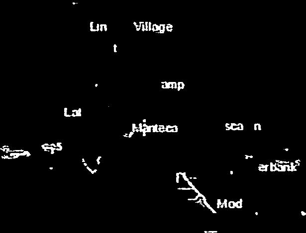


80


81


82


83


84


85
86 APPENDIX B MAJOR SB 5 BILLS (SB 5, SB 17, AB 5, AB 70, AB 162)


87

88


89


90


91


92


93


94


95


96


97


98


99


100


101


102


103


104


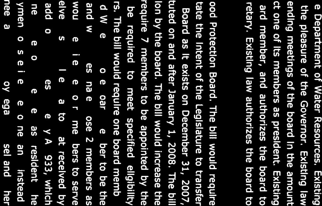


105


106


107


108


109


110


111


112


113


114


115


116


117


118


119


120


121


122


123


124

125


126


127


128


129

130

131

132


133


134

135

136


137


138


139

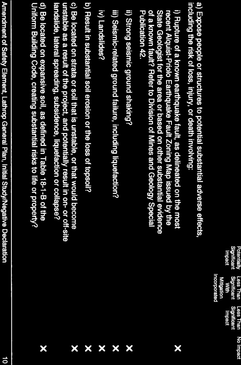
140

141

142

143


144

145

146


147


148


149

150


151


152
By Roger Churchwell San Joaquin Area Flood Control Agency.
 By Roger Churchwell San Joaquin Area Flood Control Agency www.sjafca.com Urban flood control facilities have preformed over the last 59 years Locally we are at the bottom of the bathtub Nearly 500,000
APPENDIX C. Background Information SB 5 General Plan Amendment for 200-Year Flood Protection
 APPENDIX C Background Information for 200-Year Flood Protection for 200-Year Flood Protection City of Live Oak Background Information Prepared by: 2020 L Street, Suite 400 Sacramento, CA 95811 February
Lower San Joaquin River Feasibility Study PLAN FORMULATION ADDENDUM
 PLAN FORMULATION ADDENDUM Non-Structural Measure Descriptions Elevate Critical Infrastructure This measure would raise at-risk critical structures above the design inundation level. Elevation would be
Technical Memorandum Channel Capacity Report 2018 Restoration Year
 Technical Memorandum Channel Capacity Report 2018 Restoration Year 1 Table of Contents 2 1.0 Executive Summary... ES-1 3 4 2.0 Introduction... 1 5 2.1 Objective... 2 6 2.2 CCAG Roles and Responsibilities...
Stockton General Plan 2035
 General Plans in general California Government Code Section 65300. Each planning agency shall prepare and adopt a comprehensive, long-term general plan for the physical development of the city, and of
Sacramento and San Joaquin river basins: Procedures for hydrologic analysis September 9, 2008
 Sacramento and San Joaquin river basins: Procedures for hydrologic analysis September 9, 2008 David Ford Consulting Engineers, Inc. 2015 J Street, Suite 200 Sacramento, CA 95811 Ph. 916.447.8779 Fx. 916.447.8780
CITY OF GRIDLEY 2030 General Plan
 1 TABLE OF CONTENTS Page LEGAL AUTHORITY... 1 Land Use... 2 Transportation... 2 Open Space... 3 Conservation... 3 Housing... 3 Noise... 3 Safety... 4 CHANGES IN RELEVANT LAW... 5 GENERAL PLAN IMPLEMENTATION...
General Plan. Safety Element. Adopted December 15, 1993 Amended November 9, 2011 Amended December 13, 2016 Amended September 26, 2017
 General Plan Safety Element Adopted December 15, 1993 Amended November 9, 2011 Amended December 13, 2016 County of Sacramento Office of Planning and Environmental Review This page blank. Sacramento County
Technical Memorandum No. 8 June 3, 2013 Page 2. FEMA Floodplain Mapping Flood Elevations at WWTP
 Page 2 FEMA Floodplain Mapping Flood Elevations at WWTP Existing Flood Control Facilities The City of Davis WWTP is located immediately north of the Willow Slough Bypass and west of the Yolo Bypass (see
Marysville Levee Commission
 Marysville Levee Commission Outline CVFPP Goals & Objectives Highlights of Draft Feather River RFMP Integration between Flood Protection, Agriculture and Wildlife and Floodplain Uses Proposed Projects
Dry Creek Flood Control Improvement Project
 Dry Creek Flood Control Improvement Project The following is a brief overview of the planned IRWM Stormwater Flood Management Grant Application from the Fresno Metropolitan Flood Control District (FMFCD)
Attachment B-1 Scope of Work (3/4/13) INTRODUCTION On behalf of the Lower San Joaquin and Delta South Regions, the San Joaquin Area Flood Control Agen
 INTRODUCTION On behalf of the Lower San Joaquin and Delta South Regions, the San Joaquin Area Flood Control Agen") Attachment B-1 Scope of Work (3/4/13) INTRODUCTION On behalf of the Lower San Joaquin and Delta South Regions, the San Joaquin Area Flood Control Agency (SJAFCA) appreciates the California Department of
Attachment B-1 Scope of Work (3/4/13) INTRODUCTION On behalf of the Lower San Joaquin and Delta South Regions, the San Joaquin Area Flood Control Agency (SJAFCA) appreciates the California Department of
4.3 GROUNDWATER Impact Issues and Evaluation Criteria
 4.3 GROUNDWATER 4. Environmental Consequences and Mitigation Measures This section describes changes to groundwater conditions associated with the project alternatives, as compared to the No Action alternative.
acquiring, managing, and disposing of federal lands and facilities;
 2.2.1 HYDROLOGY AND FLOODPLAIN This section discusses and analyzes the surface hydrology and water quality characteristics of the project. The information provided in this section is based on the Preliminary
Chapter Content. Tables. Figures. Chapter 3 Watershed and Delta Hydrology...33 Precipitation...33 Runoff Index...34 Delta Outflows...
 MWQI Summary and Findings from Data Collected August 199 through September 1 Chapter 3 Watershed and Delta Hydrology - Content Chapter Content Chapter 3 Watershed and Delta Hydrology...33...33 Runoff Index...3
The Nature Conservancy Cosumnes River Preserve Franklin Boulevard Galt CA 95632
 Study Partners The Nature Conservancy Cosumnes River Preserve 13501 Franklin Boulevard Galt CA 95632 East Bay Municipal Utility District 1 Winemaker Way, Unit K Lodi CA 95240 Sacramento County Water Agency
3. AFFECTED ENVIRONMENT
 3. AFFECTED ENVIRONMENT This chapter presents a general description of the physical environment of the project area and vicinity. The existing condition of resources sets the baseline against which the
ATTACHMENT A I. INTRODUCTION
 ATTACHMENT A CERTIFICATION OF THE FINAL ENVIRONMENTAL IMPACT REPORT FOR THE SAN JOAQUIN AREA FLOOD CONTROL AGENCY (SJAFCA) LOWER SAN JOAQUIN RIVER FEASIBILITY STUDY (LSJRFS) AND SJAFCA S FINDINGS OF FACT
IV. ENVIRONMENTAL IMPACT ANALYSIS G. HYDROLOGY/WATER QUALITY
 IV. ENVIRONMENTAL IMPACT ANALYSIS G. HYDROLOGY/WATER QUALITY ENVIRONMENTAL SETTING The project site is located in the Wilshire community of the City of Los Angeles and is bound by S. Wetherly Drive to
Upper San Joaquin River Regional Flood Management Plan
 Upper San Joaquin River Regional Flood Management Plan Regional Flood Protection Now and in the Future Workshop 9: Project Prioritization and Financial Analysis Wednesday August 20 th, 2014 Lower San Joaquin
3F. Hydrology and Water Quality
 This section provides an analysis of potential hydrological and water quality impacts associated with implementation of the proposed project. The section also evaluates and describes the potential impacts
Farmington Dam Repurpose Project
 Farmington Dam Repurpose Project 2017 $158,100,000 to re-purpose the Farmington Dam from flood protection only to a long-term water storage facility that increases water supply reliability to the region.
MUNICIPAL SERVICE REVIEW AND SPHERE OF INFLUENCE UPDATES FOR
 MUNICIPAL SERVICE REVIEW AND SPHERE OF INFLUENCE UPDATES FOR ORESTIMBA CREEK FLOOD CONTROL DISTRICT SAND CREEK FLOOD CONTROL DISTRICT Prepared By: Stanislaus Local Agency Formation Commission 1010 Tenth
DRAFT EXISTING CONDITIONS, CONSTRAINTS AND OPPORTUNITIES REPORT
 2.6 SAFETY ELEMENT The Safety Element of a General Plan addresses protection from any unreasonable risks associated with hazards such as fire, flood, and earthquakes. Public safety issues related to fire
Summary ECONOMIC STUDIES
 ECONOMIC STUDIES The Comprehensive Study performed basin-wide economic evaluations that incorporated a risk-based analysis. The primary tool for the economic studies was the Corps Flood Damage Analysis
ENGINEERING ECOSYSTEM RESTORATION
 APPENDIX D ENGINEERING ECOSYSTEM RESTORATION ENGINEERING APPENDIX FOR EXISTING CONDITION ANALYSIS FOR RISK INFORMED DECISION MAKING FOR PROJECT ALTERNATIVE SELECTION DELTA ISLANDS AND LEVEES FEASIBILITY
CHAPTER 3 Water Supply
 CHAPTER 3 3.1 WATER SUPPLY OVERVIEW This chapter describes the sources of water available to the City and MID. The chapter includes a description of each water source, including limitations, water quality
Appendix VI: Illustrative example
 Central Valley Hydrology Study (CVHS) Appendix VI: Illustrative example November 5, 2009 US Army Corps of Engineers, Sacramento District Prepared by: David Ford Consulting Engineers, Inc. Table of contents
Draft Environmental Impact Report
 Revised Draft Environmental Impact Report San Francisquito Creek Flood Protection, Ecosystem Restoration, and Recreation Project Upstream of Highway 101 This notice announces that a Draft Environmental
A Case Study: Imperial Valley, California
 University of Colorado Law School Colorado Law Scholarly Commons Western Water: Expanding Uses/Finite Supplies (Summer Conference, June 2-4) Getches-Wilkinson Center Conferences, Workshops, and Hot Topics
4.5 WASTEWATER, STORM DRAINAGE, AND FLOODING
 4.5 WASTEWATER, STORM DRAINAGE, AND FLOODING INTRODUCTION This section addresses the potential wastewater, storm drainage, and flooding impacts resulting from development under the Draft General Plan.
Chapter 21 Stormwater Management Bylaw
 Chapter 21 Stormwater Management Bylaw SECTION 1. PURPOSE The purpose of this Bylaw is to: implement the requirements of the National Pollutant Discharge Elimination System (NPDES) General Permit for Storm
4. Present Activities and Roles
 4. Present Activities and Roles The present missions, authorities, activities and roles of the various agencies involved with flood protection, floodplain management and flood-damage reduction are identified
Multi-Benefit Planning in the San Joaquin River Basin-wide Feasibility Study
 Multi-Benefit Planning in the San Joaquin River Basin-wide Feasibility Study September 8 th, 2016 Presented by: Eric Tsai, P.E. California Department of Water Resources Eric.Tsai@water.ca.gov Jeremy Thomas,
Technical Memorandum Public Draft Channel Capacity Report 2019 Restoration Year
 Public Draft Channel Capacity Report 2019 Restoration Year 1 Table of Contents 2 1.0 Executive Summary... 1 3 2.0 Introduction... 1 4 3.0 Study Area... 3 5 4.0 Completed Channel Capacity Studies and Related
CHAPTER 7. San Dieguito River Flooding Adaptation
 CHAPTER 7 San Dieguito River Flooding Adaptation This chapter includes a range of adaptation measures to address vulnerabilities from flooding along the San Dieguito River, including the river valley,
DRAINAGE AND NATURAL AQUIFER GROUNDWATER RECHARGE ELEMENT
 Goal 7.0. To optimize integrated stormwater management in order to reduce damage and impacts from sea level rise and flooding, promotes recharge to the Surficial Aquifer System (SAS), improve and protect
CHAPTER 7. San Dieguito River Flooding Adaptation
 CHAPTER 7 San Dieguito River Flooding Adaptation This chapter includes a range of adaptation measures to address vulnerabilities from flooding along the San Dieguito River, including the river valley,
Friant Dam and Millerton Reservoir
 San Joaquin River Restoration Program Floodplain Management Association Presentation SJRRP Update Continued: Impacts from Subsidence April 18, 2013 1 Friant Dam and Millerton Reservoir Completed in 1942
APPENDIX A. Project Scoping
 APPENDIX A Project Scoping Notice of Preparation To: From: Agencies and Interested Parties Paul Brunner, Executive Director, Three Rivers Levee Improvement Authority Date: June 13, 2006 Subject: Notice
RIPON MUNICIPAL SERVICE REVIEW AND SPHERE OF INFLUENCE PLAN
 RIPON AND SPHERE OF INFLUENCE PLAN Prepared by the City of Ripon For San Joaquin LAFCO October 29, 2009 2009 PUBLIC REVIEW DRAFT SUBMITTED BY CITY OF RIPON OCTOBER 29, 2009 Table of Contents TABLE OF CONTENTS
California Drought Update. The 2016 CALAFCO Annual Conference Program. Water Status Update: Where Are We? Where Are We Going?
 California Drought Update The 2016 CALAFCO Annual Conference Program Water Status Update: Where Are We? Where Are We Going? October 26, 2016 David Inouye Water Management Branch Chief Department of Water
NOTICE OF PREPARATION
 NOTICE OF PREPARATION Date: June 12, 2014 To: From: Subject: Governor s Office of Planning and Research/State Clearinghouse Unit, Responsible Agencies, Trustee Agencies, and Interested Parties Announcement
Initial 2018 Restoration Allocation & Default Flow Schedule January 23, 2018
 Initial 2018 Restoration Allocation & Default Schedule January 23, 2018 Bureau of Reclamation 2800 Cottage Way, MP-170 Sacramento, California 95825 Introduction The following transmits the initial 2018
FINDINGS OF FACT AND STATEMENT OF OVERRIDING CONSIDERATIONS
 WEST SACRAMENTO AREA FLOOD CONTROL AGENCY SOUTHPORT SACRAMENTO RIVER EARLY IMPLEMENTATION PROJECT (BORROW ONE PROJECT) FINDINGS OF FACT AND STATEMENT OF OVERRIDING CONSIDERATIONS P R E P A R E D F O R
CONCEPTUAL DEVELOPMENT PLAN Land Use, Governance, Funding & Implementation
 M a r y l a n d P a r k L a k e D i s t r i c t Advisory Committee Meeting CONCEPTUAL DEVELOPMENT PLAN Land Use, Governance, Funding & Implementation City of Maryland Heights, Missouri November 07, 2018
Technical Memorandum No Basis of Comparison
 Pajaro River Watershed Study in association with Technical Memorandum No. 1.2.1 Basis of Comparison Task: Basis of Comparison To: PRWFPA Staff Working Group Prepared by: J. Schaaf Reviewed by: R. Raines
4.6 - Hydrology and Water Quality
 City of Wasco - Wasco Center Walmart Hydrology and Water Quality 4.6 - Hydrology and Water Quality 4.6.1 - Introduction This section provides an evaluation of hydrology and water quality. The analysis
San Francisco Public Utilities Commission Hydrological Conditions Report For May 2017 J. Chester, C. Graham, & M. Tsang, June 5, 2017
 San Francisco Public Utilities Commission Hydrological Conditions Report For May 2017 J. Chester, C. Graham, & M. Tsang, June 5, 2017 High inflows increased inflows to and releases from Hetch Hetchy. The
Hydrologic Characteristics of the Owens River Basin below the Upper Owens River
 Appendix T. Hydrologic Characteristics of the Owens River Basin below the Upper Owens River The hydrology of Mono Basin is described in detail in Chapter 3A. This appendix describes the Owens River basin
1. PURPOSE OF AND NEED FOR ACTION
 1. PURPOSE OF AND NEED FOR ACTION INTRODUCTION The Bureau of Reclamation (Reclamation) and the San Joaquin River Group Authority (Authority) are jointly preparing this Environmental Impact Statement/Environmental
LAKE COUNTY STORMWATER MANAGEMENT COMMISSION GENERAL PERMIT NUMBER 3 AUTHORIZING MINOR MAINTENANCE DREDGING ACTIVITIES
 I. INTRODUCTION This document is created under the authorities granted to the Lake County Stormwater Management Commission (LCSMC) with respect to the Lake County Watershed Development Ordinance (WDO)
Central Orange County Integrated Regional Water Management Plan
 12 CLIMATE CHANGE 12.1 REGIONAL CLIMATE The region lies in the semipermanent high-pressure zone of the eastern Pacific, resulting in a mild climate characterized by warm, dry summers and cool, wet winters
RESOLUTION NO. R2013-XXXX
 RESOLUTION NO. R2013-XXXX A RESOLUTION OF THE CITY COUNCIL OF THE CITY OF MANTECA MAKING FINDINGS AND APPROVING GENERAL PLAN AMENDMENT NO. GPA-13-96-03 FOR THE MANTECA GENERAL PLAN SAFETY ELEMENT UPDATE
EXECUTIVE SUMMARY ES.1 BACKGROUND
 EXECUTIVE SUMMARY ES.1 BACKGROUND The San Francisco Bay/Sacramento-San Joaquin Delta Estuary (Bay/Delta Estuary) is a critically important part of California s natural environment and economy. In recognition
Yuba County IRWMP 2015 UPDATE APPENDIX 10-1 General Plan Relation to IRWMP
 APPENDIX 10-1 General Plan Relation to IRWMP 1 of 13 Community Development Element Goal CD11: Quality of Life and Local Advantages Provide a high quality of life and take advantage of the County s economic
Appendix A Regional Setting and Context
 Appendix A Regional Setting and Context 1 1. Overview to Appendix A This appendix provides more detailed information on regional setting and context than that contained in Chapter 2 of the RFMP. This chapter
Woodlake General Plan Draft Environmental Impact Report
 5.0 UNAVOIDABLE ADVERSE ENVIRONMENTAL EFFECTS The following potential adverse environmental effects appear to be unavoidable if the Woodlake General Plan is implemented, even if certain mitigation measures
9 CEQA Alternatives. Alternatives
 9 CEQA Alternatives 9 CEQA Alternatives CHAPTER 9 CEQA Alternatives Sections Tables 9.1 Introduction 9.2 Alternatives Analysis 9.3 Comparison of Alternatives to the Proposed WSIP 9.4 Alternatives Identification
Subject: Notice of Preparation of a Draft Environmental Impact Report
 NOTICE OF PREPARATION From: Santa Clara Valley Water District 5750 Almaden Expressway San Jose, CA 95118 Subject: Notice of Preparation of a Draft Environmental Impact Report Project Title: Guadalupe Dam
The origin and evolution of the california state plan of flood control levee system
 July 3 7, The origin and evolution of the california state plan of flood control levee system Graham Bradner a, Emilie Singleton b Engineering Division, GEI Consultants, Sacramento, United States a gbradner@geiconsultants.com
Appendix Q Draft Location Hydraulic Study Report For the State Route 32 Widening Between Fir Street and Yosemite Drive at Dead Horse Slough and South
 Appendix Q Draft Location Hydraulic Study Report For the State Route 32 Widening Between Fir Street and Yosemite Drive at Dead Horse Slough and South Fork Dead Horse Slough in the, California Draft Location
CEDAR RUN WATERSHED ACT 167 STORMWATER MANAGEMENT PLAN FINAL REPORT
 CEDAR RUN WATERSHED ACT 167 STORMWATER MANAGEMENT PLAN FINAL REPORT I. PURPOSE OF THE REPORT The purpose of this report is to summarize the findings and recommendations of the Cedar Run Watershed Act 167
CHAPTER 3 FLOOD RELATED STUDIES
 CHAPTER 3 FLOOD RELATED STUDIES Although the area has experienced regular flooding there have been few formal flood studies until more recently. There are a number of water quality studies in the basins.
Sacramento Area Flood Control Agency. May State Clearinghouse No Prepared for: Prepared by: Consulting Engineers and Scientists
 Addendum No. 3 (North Sacramento Streams) to the Environmental Impact Report on the North Sacramento Streams, Sacramento River East Levee, Lower American River, and Related Flood Improvements Project Prepared
Lower San Joaquin and Delta South Regional Flood Management Plan
 Lower San Joaquin and Delta South Regional Flood Management Plan Draft Document for Public Review/Comment January 2014 Contents 1 Acronyms and Abbreviations iv 2 Executive Summary 1 3 Introduction 2 3.1
Distributed Storage Alternative Screening Analysis February 17, 2015
 Distributed Storage Alternative Screening Analysis February 17, 2015 Executive Summary The Distributed Storage Alternative (DSA) was conceptualized during the public comment and alternative screening process
2030 General Plan. November 1, :00 p.m.
 2030 General Plan GPAC Meeting #7 November 1, 2007 7:00 p.m. Planning Commission Review of Land Use Map Planning Commission concurred with most GPAC recommendations Exceptions include: Consider area along
CHAPTER 11 Climate Change Considerations
 CHAPTER 11 CHAPTER 11 CLIMATE CHANGE CONSIDERATIONS 11.1 INTRODUCTION Human activities, such as energy production and land development also result in both direct and indirect emissions that contribute
Subject: Notice of Preparation of a Draft Environmental Impact Report
 NOTICE OF PREPARATION From: Santa Clara Valley Water District 5750 Almaden Expressway San Jose, CA 95118 Subject: Notice of Preparation of a Draft Environmental Impact Report Project Title: Calero Dam
LAKE COUNTY HYDROLOGY DESIGN STANDARDS
 LAKE COUNTY HYDROLOGY DESIGN STANDARDS Lake County Department of Public Works Water Resources Division 255 N. Forbes Street Lakeport, CA 95453 (707)263-2341 Adopted June 22, 1999 These Standards provide
Pajaro River Watershed Flood Prevention Authority. Phase 3 and 4a. Pajaro River Watershed Study
 Pajaro River Watershed Flood Prevention Authority Phase 3 and 4a FEBRUARY 2005 Funding for this project has been provided in full or in part through a contract with the SWRCB pursuant to the Costa-Machado
EAST BAY MUNICIPAL UTILITY DISTRICT
 EAST BAY MUNICIPAL UTILITY DISTRICT DATE: May 6, 2010 MEMO TO: Board of Directors THROUGH: Dennis M. Diemer, General Manager td^i FROM: SUBJECT: Alexander R. Coate, Director of Water and Natural Resources
Amendment to EBMUD Retirement System Ordinance (No. 40) - Section 21 First Reading. Board of Directors March 10, 2015
 - Section 21 First Reading. Board of Directors March 10, 2015") Amendment to EBMUD Retirement System Ordinance (No. 40) - Section 21 First Reading Board of Directors March 10, 2015 Updates to Ordinance No. 40 Section 21 provides for an optional modification of a member
Amendment to EBMUD Retirement System Ordinance (No. 40) - Section 21 First Reading Board of Directors March 10, 2015 Updates to Ordinance No. 40 Section 21 provides for an optional modification of a member
Presentation Overview
 Little Dry Creek Restoration Deep River Flood Risk Management Final Presentation to LCRBDC June 10, 2015 Presentation Overview Project Overview & Background Information Data Collection Model Development
Freight Street Development Strategy
 Freight Street Development Strategy Appendix B: Naugatuck River Floodplain Analysis Freight Street Development Strategy DECEMBER 2017 Page B-1 1.0 NAUGATUCK RIVER FLOODPLAIN AT FREIGHT STREET 1.1 Watershed
Sacramento County Board of Supervisors Sacramento County Water Agency. October 21, 2008
 Sacramento County Board of Supervisors Sacramento County Water Agency October 21, 2008 Adopt Resolutions Approving the Sacramento County and the Sacramento County Water Agency Policies With Respect to
V. PUBLIC HEALTH AND SAFETY
 V. PUBLIC HEALTH AND SAFETY V. PUBLIC HEALTH AND SAFETY The County has responsibility to plan for a safe environment in which the public is reasonably protected from risks to life, health, and property.
INDIAN CREEK WATERSHED PLAN EXECUTIVE SUMMARY
 INDIAN CREEK WATERSHED PLAN EXECUTIVE SUMMARY The Indian Creek Watershed covers a 38 square mile area in southern Lake County, Illinois that drains 24,116 acres before discharging into the Des Plaines
Spring Forecast Based Operations, Folsom Dam, California
 Spring Forecast Based Operations, Folsom Dam, California Paul E. Pugner, P.E. Chief, Water Management Section Sacramento District U.S. Army 1325 J Street, Room 1126 Sacramento, CA 95814-2922 Tel: (916)
SECTION 9.0 Effects Found Not To Be Significant
 SECTION 9.0 Effects Found Not To Be Significant 9.0 EFFECTS FOUND NOT TO BE SIGNIFICANT The City of Santa Clarita conducted an Initial Study in April 2006 to determine significant effects of the proposed
Short List of Projects No. PROJECT
 Short List of Projects No. PROJECT 1 Smith Canal Closure Structure 2 RD 17 Levee Strengthening 3 Paradise Cut Improvements (Base Case) 4 Tentatively Selected Plan from the Lower San Joaquin Feasibility
Central Valley hydrology study
 Central Valley hydrology study November 29, 2015 Prepared for California Department of Water Resources Letter of agreement #4600007762 Prepared by US Army Corps of Engineers Sacramento District and David
Jose Gutierrez - Chief Operating Officer. Water Education Foundation, April 4,2019
 Jose Gutierrez - Chief Operating Officer Water Education Foundation, April 4,2019 Presentation Overview Who We Are CVP South of Delta Allocation Groundwater Conditions Sustainable Groundwater Management
LECTURE #19: Floods & Flooding Hazards
 GEOL 0820 Ramsey Natural Disasters Spring, 2018 LECTURE #19: Floods & Flooding Hazards Date: 29 March 2018 I. Flooding Hazards: what is a flood? o damaging floods result when the volume of river flow exceeds
Appendix J. Existing Efforts for Identifying Multi-Benefit Projects
 Appendix J Existing Efforts for Identifying Multi-Benefit Projects Water Purveyor Projects Existing Efforts for Identifying Multi Benefits Projects In-lieu groundwater recharge under RWA planning efforts
2017 Central Valley Flood Protection Plan Update: Overview
 2017 Central Valley Flood Protection Plan Update: Overview 2015 FMA Conference CVFPP Overview- Mike Mierzwa, DWR Basin-wide Feasibility Study Planning Context- Eric Tsai, DWR Technical Tools/Methodologies-
Water for Southern California: How Bay-Delta is Key to All of the Above Strategy
 Water for Southern California: How Bay-Delta is Key to All of the Above Strategy Stephen N. Arakawa Manager, Bay-Delta Initiatives The Metropolitan Water District of Southern California October 15, 2016
Water Supply Effects Modeling: San Joaquin Tributary Streamflow Requirements
 Water Supply Effects Modeling: San Joaquin Tributary Streamflow Requirements Will Anderson State Water Resources Control Board Division of Water Rights April 12, 2016 Overview Regulatory background and
City and County of San Francisco San Francisco Planning Department. Summary Presentation on
 City and County of San Francisco San Francisco Planning Department Summary Presentation on Draft Program Environmental Impact Report for the San Francisco Public Utilities Commission s Water System Improvement
11 HEALTH AND SAFETY ELEMENT
 11 HEALTH AND SAFETY ELEMENT 11 The Butte County Fire Department has critical responsibilities for the safety of Butte County citizens and property. Photo courtesy of the Butte County Department of Development
5.3 Tuolumne River System and Downstream Water Bodies
 5.3 Tuolumne River System and Downstream Water Bodies Section 5.3 Subsections 5.3.1 Stream Flow and Reservoir Water Levels 5.3.2 Geomorphology 5.3.3 Surface Water Quality 5.3.4 Surface Water Supplies 5.3.5
Lower San Joaquin Feasibility Study Environmental Impact Report/ Supplemental Environmental Impacts Statement
 Sacramento District Engineering Division Lower San Joaquin Feasibility Study Environmental Impact Report/ Supplemental Environmental Impacts Statement San Joaquin County, California Appendix B: Engineering
Fargo-Moorhead Flood Risk Management Project Supplement to Environmental Impact Statement (SEIS) Final Preparation Notice May 21, 2018
 Final Preparation Notice May 21, 2018") Fargo-Moorhead Flood Risk Management Project Supplement to Environmental Impact Statement (SEIS) Final Preparation Notice May 21, 2018 1. Title of EIS being supplemented and date of completion: Final Environmental
Fargo-Moorhead Flood Risk Management Project Supplement to Environmental Impact Statement (SEIS) Final Preparation Notice May 21, 2018 1. Title of EIS being supplemented and date of completion: Final Environmental
Title 26 DEPARTMENT OF THE ENVIRONMENT Subtitle 04 REGULATION OF WATER SUPPLY, SEWAGE DISPOSAL, AND SOLID WASTE
 Title 26 DEPARTMENT OF THE ENVIRONMENT Subtitle 04 REGULATION OF WATER SUPPLY, SEWAGE DISPOSAL, AND SOLID WASTE Chapter 03 Water Supply and Sewerage Systems in the Sub division of Land in Maryland Authority:
Natural Hazards, Climate Change & DCR. DCR s 2018 vulnerability assessment survey for the State Hazard Mitigation & Climate Adaptation Plan
 Natural Hazards, Climate Change & DCR DCR s 2018 vulnerability assessment survey for the State Hazard Mitigation & Climate Adaptation Plan What is climate change? A statistically significant variation
Port of Camas/Washougal Levee Recertification and Engineering Analysis Request for Proposal May 3, 2011
 I. Project Summary As part of their Map Modernization Program, FEMA has initiated a countywide Flood Insurance Study (FIS) and Digital Flood Insurance Rate Map (DFIRM) for the Port of Camas/Washougal.
CHAPTER 8 FLOOD CONTROL 8.1 ENVIRONMENTAL SETTING/AFFECTED ENVIRONMENT YUBA REGION
 CHAPTER 8 FLOOD CONTROL Floods can be damaging and costly, often resulting in loss of life or substantial property damage. Levees, dams, and reservoirs provide flood control throughout most of California.
GENERAL OVERVIEW MEETING JANUARY 10, 2019
 Upper Barataria Basin Coastal Storm Risk Management and The Amite River and Tributaries-Comprehensive Study East of the Mississippi River, Louisiana Feasibility Studies GENERAL OVERVIEW MEETING JANUARY
AN ORDINANCE OF THE COUNTY OF SAN BERNARDINO, STATE OF CALIFORNIA, ADDING ARTICLE 5 TO CHAPTER 6 OF DIVISION
 ORDINANCE NO. AN ORDINANCE OF THE COUNTY OF SAN BERNARDINO, STATE OF CALIFORNIA, ADDING ARTICLE TO CHAPTER OF DIVISION OF TITLE OF THE SAN BERNARDINO COUNTY CODE RELATING TO GROUNDWATER MANAGEMENT IN THE