2017 Central Valley Flood Protection Plan Update: Overview
|
|
|
- Jean Parks
- 6 years ago
- Views:
Transcription
1 2017 Central Valley Flood Protection Plan Update: Overview 2015 FMA Conference CVFPP Overview- Mike Mierzwa, DWR Basin-wide Feasibility Study Planning Context- Eric Tsai, DWR Technical Tools/Methodologies- Rummy Sandhu & David Arrate, DWR Climate Change Considerations- Amy Bindra, DWR Ecosystem Benefits Analysis- Mary Jimenez, DWR Assessing Value of Other Economic Benefits- Steve Hatchett, CH2M Hill Next Steps and Key Messages- Mary Jimenez, DWR 1

2 2012 Central Valley Flood Protection Plan 2
3 Outcome Based Planning CVFPP Goals Primary Goal: Improve flood risk management Reduce the chance of flooding Reduce damages once flooding occurs Improve public safety, preparedness, and emergency response Supporting Goals Improve Operations and Maintenance Promote Ecosystem Functions Promote Multi-benefit Projects Improve Institutional Support Intended Outcomes 3


4 One Process, Many Activities GOAL: Supporting comprehensive investments to better manage flood waters 4
5 Basin-Wide Feasibility Studies Planning Context 1


6 2012 CVFPP State Systemwide Investment Approach 3

7 Basin-wide Feasibility Study Purpose & Scope Refine scale/location of flood system elements; integrate environmental conservation Evaluate systemwide hydraulic effects, and ecosystem restoration opportunities Inform 2017 CVFPP update 2
8 Basin-wide Feasibility Study Goals Primary Goal Improve Flood Risk Management Supporting Goals Promote Ecosystem Functions Improve Operations and Maintenance Promote Multi- Benefit Projects Balanced Reasonable Cost-efficient 9

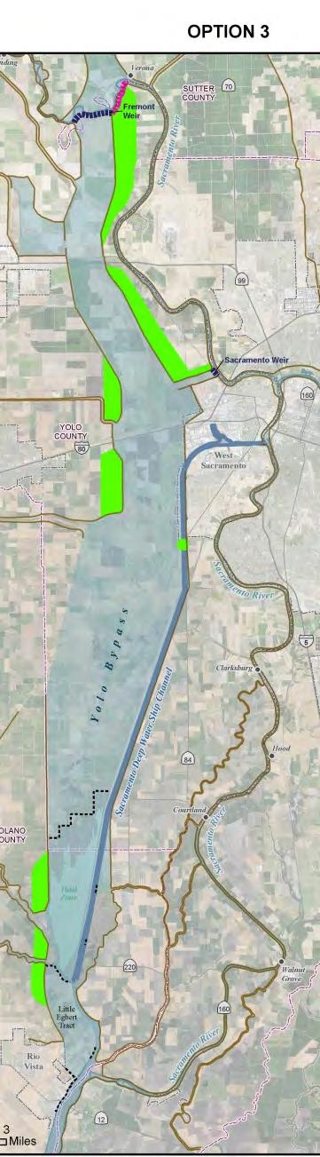


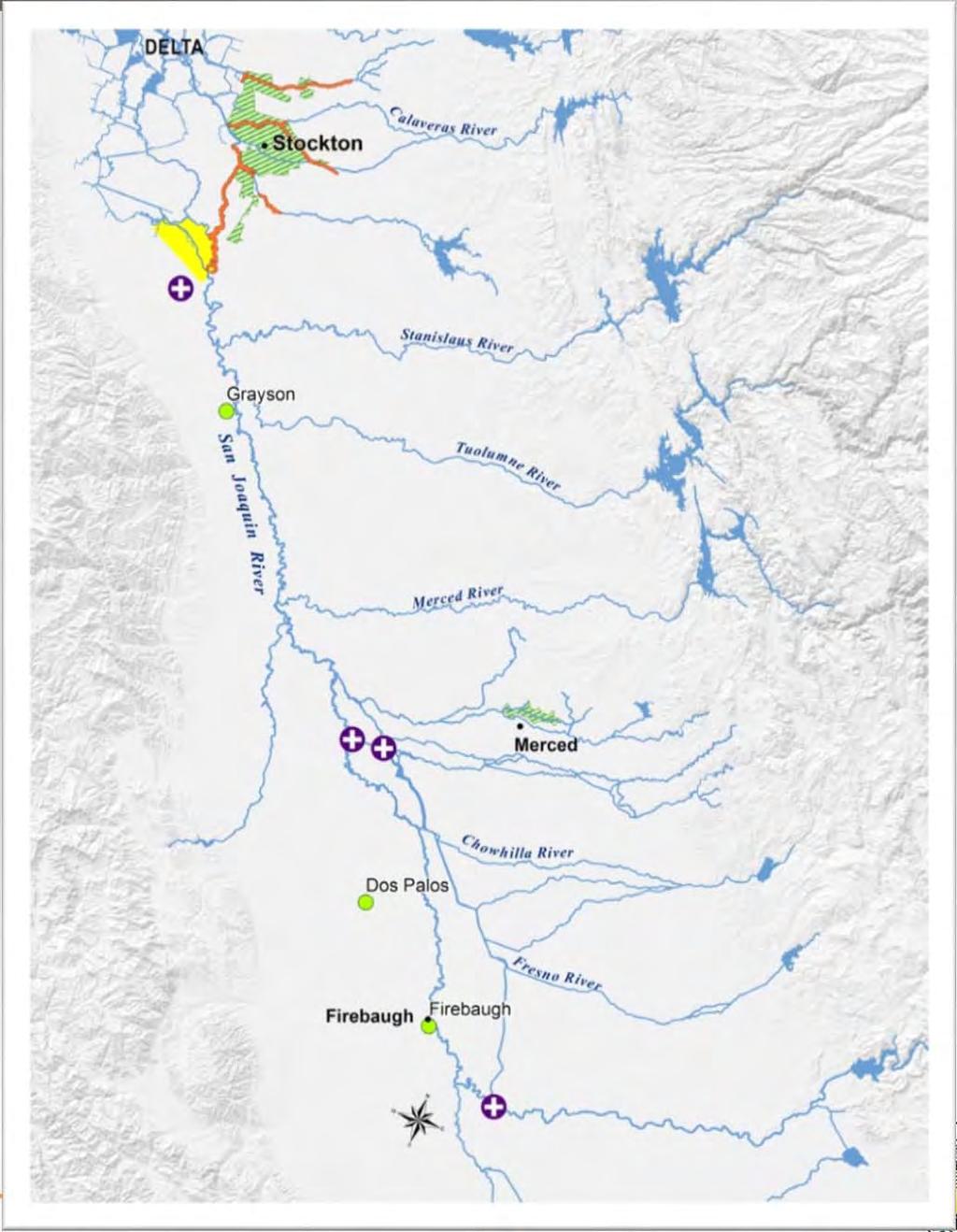
9 Yolo Bypass Options 4
10 Basin-Wide Technical Analysis Tools & Methodology


")


")


")
")
 Cost")


11 Technical Analysis: Tools & Methodology Reservoir Flow (HEC-ResSim) Local Flow (HEC- HMS) Riverine Hydraulics (HEC-RAS) Geotechnical Evaluation (ULE/NULE) Flood Hydrology Analysis (CVHS) Delta Hydraulics (RMA2) Economic & Life Risk Analysis (HEC-FDA) Historical Data (CDEC/ USGS) Climate Change (VIC) Floodplain Hydraulics (FLO2D) Cost Estimates Ecosystem Water Quality Commercial Fisheries Water Supply Regional Economics Recreation Open/Space Navigation Loss of Services


12 Flood Risk Analysis of Key Locations Regulated Flow Impact Area Index Point Channel Stage Regulated Stage

 2 3 4 ULE/NULE 1 5 8 Updated")

13 System-wide Tools Applications CVHS HEC-ResSim CVFED HEC-RAS CVFED HEC-RAS RMA2 HEC-HMS/ Bulletin 17B (CVHS) ULE/NULE Updated Structure Inventory, Multiple flooding sources 7 6 CVFED FLO-2D HEC-RAS HEC-FDA 13


14 Sacramento BWFS: What We ve Learned Our flood system needs to be modernized to meet today s needs and be resilient to future changes. Sacramento and Fremont Weir expansions can provide significant cross-regional stage reduction. Yolo Bypass setbacks provide varying levels of flood and ecosystem benefits. Sacramento Weir and Bypass Expansions Fremont Weir Expansions


15 San Joaquin BWFS: Stage Frequency in the Delta Tidal Influenced Elements Affected Paradise Cut RD17 Stockton/Delta Front RMA2 Bay-Delta Model Dynamic Tide Stage Boundaries Total Latitude Flow Frequency

16 San Joaquin BWFS: Example Multi-Objective Element Firebaugh Small Community Improvements Flood Risk Improvement Ecosystem Benefits Hydraulic Impacts
17 Climate Change Considerations 17

18 Hydrologic Variability Considerations 18
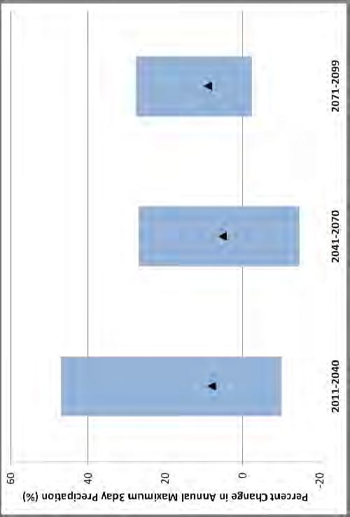
19 How Temperature Increases Influence Storm Runoff Volumes Existing Rain / Snow Trends Future Rain / Snow Trends 19
 38.8 cm (1.27 ft.) 83.1 cm (2.73 ft.) 2100 42.4 cm 91.9 cm 166.")
20 How Sea Level Rise Influences System Outflow Estimates of Future Sea Level Rise in California Low Mean High cm 14.4 cm 29.7 cm cm 28.0 cm 60.8 cm 2062* 18.5 cm (0.61 ft.) 38.8 cm (1.27 ft.) 83.1 cm (2.73 ft.) cm 91.9 cm cm (Source: NRC, 2012) 20


21 Climate Change Impacts Contributes to rise in extreme weather events Expected to generate more extreme floods, more seasonal rain, less snow and rising sea levels Increases stress on the system 21
22 Climate Change Approach for 2017 CVFPP Multi-phased approach Phase 1 included in 2012 plan Phase 2a 2007 global climate models, 112 independent climate projections Phase 2b More robust analysis and integration; 2013 global climate models, 200 independent climate projections Uses latest science and data Integrates existing hydrologic and flood risk approaches Consistent with State s climate change policies 22

23 Increasing Temperature and Precipitation Extremes 23


24 How Temperature Increases Influence Storm Runoff Volumes Existing Rain / Snow Trends Future Rain / Snow Trends 24


25 CVFPP Climate Change Approach Linking atmospheric processes, precipitation and temperature fields, and watershed conditions to inform changes in flood risk Atmospheric River 45ºN Atmospheric River Stream flow 35ºN 25ºN 140ºE 170ºE 160ºW 130ºW 100ºW Precipitation Watershed Historical Projected Temperature Adjusted Unregulated Flow Frequency Curves Projected General Circulation Model Risk Analysis and Flood Management Planning Historical
26 Ecosystem Benefits Analysis for Multi-Objective Flood Planning 26
27 Today s Discussion Ecosystem Integration into the Central Valley Flood Protection Plan - Overview of the CVFPP Draft Conservation Strategy - Development of Multi-Benefit Opportunities BWFS Ecosystem Benefits Analyses - Overview of Purpose and Approach 27

28 Ecosystem Integration into the CVFPP CVFPP Draft Conservation Strategy 28
29 Multi-Benefit Project Development The Draft Conservation Strategy guided development of ecosystem restoration concepts for flood system elements currently under consideration 29
30 Fremont Weir Upper Yolo Bypass Ecosystem Integration Concept Elkhorn Basin
31 Conservation Strategy guided development of restoration concepts Multiple restoration concepts developed to show range of options Ongoing collaboration with stakeholders
32 Opportunities to expand riparian and shaded riverine aquatic (SRA) habitat Would provide benefits to target fish and bird species
33 Opportunities to work with local interests to expand floodplain inundation Would be in coordination with agricultural practices Would provide local and downstream benefits to target fish species

34 Opportunities to reduce existing fish passage barriers and expand fish passage in and out of the bypass Would provide benefits to adult and juvenile fish species
35 Ecosystem Benefits Analyses 35
36 Purpose of Ecosystem Benefits Analyses Informs decision making and understanding of tradeoffs Informs subsequent project implementation Quantifies ecosystem values in a way that helps track progress in meeting Conservation Strategy goals Informs discussions with resource agencies on permitting for projects and long-term O&M Develops tools that allow consistent evaluation of projects in regional context and meet USACE requirements 36
37 Ecosystem Benefits Approach Based on a modified USACE Habitat Equivalency Analysis (HEA) methodology Uses the ecosystem features identified in the restoration concepts as the basis for the benefits analyses - as compared to existing conditions Coordinated models were developed: An Ecosystem Model that addresses habitat structure and function Species Models that address target species and habitat connectivity 37
38 Ecosystem Benefits Example Results Net Benefits for Habitats Benefits for Species (Ex: Swainson s Hawk) Existing Configuration 1 Configuration 2 Configuration 3 Configuration 3 2 Value Weighted Acres Configuration 4 1 Channel Bank Riparian Marsh-Other Wetland ,000 1,500 2,000 Fully Functional Acre Equivalents 0 Concept 1 Concept 2 Concept 3 Concept 4 Concept 5 Concept 6 System Element 38
39 Assessing Value of Other Economic Benefits of the CVFPP 39


40 CVFPP Seeks to Provide a Range of Benefits Water supply and water quality Flood risk management Hydropower Ecosystem restoration Recreation and open space Navigation Commercial fisheries Social and regional economic effects 40
")
41 Open space Enhances Property Value Hedonic demand approach Existing study of protected wildlife areas near cities Evaluated the effect of open space proximity to property value Adjusted for other property features California property value 3-6% higher if near protected wildlife area (all else equal) 41
 network to road centerline geolocations.")

42 Loss of Transportation Service Linked California Statewide Travel Demand Model (CSTDM) network to road centerline geolocations. Overlaid flood inundation areas and depths on road network Assessed road operations and closures Used CSTDM to estimate traffic volumes, routes, travel times Estimated costs of travel delays, rerouting 42

43 CSTDM Road Network- Central Valley Portion 43

44 Linked Analysis Will Provide New Way of Assessing Transportation Service Benefits 44
45 Where We re Going Next Steps and Key Messages 45
46 Basin-wide Feasibility Study Next Steps Evaluation and comparison of BWFS options Continued stakeholder engagement Formulation of State-Preferred Plan Draft BWFS by End of 2015 Further coordination/refinement through 2017 CVFPP 14

47 CVFPP Next Steps Outcome-Based Planning for 2017 CVFPP Update Continued collaboration with stakeholders and parallel planning efforts (e.g., RFMP Phase 2) Evaluation of flood O&M requirements for existing and future flood system and ecosystem features Documentation of monitoring/tracking value of investments 47
48 Key Messages DWR is using the latest tools, models and methodologies to evaluate and compare various planning options Multiple planning efforts at different scales are being conducted to support the 2017 CVFPP DWR is conducting systemwide, multiobjective planning studies in two river basins to achieve resiliency and a wide range of public values 48
Multi-Benefit Planning in the San Joaquin River Basin-wide Feasibility Study
 Multi-Benefit Planning in the San Joaquin River Basin-wide Feasibility Study September 8 th, 2016 Presented by: Eric Tsai, P.E. California Department of Water Resources Eric.Tsai@water.ca.gov Jeremy Thomas,
Assessing the Ecological Benefits of River and Floodplain Restoration
 Assessing the Ecological Benefits of River and Floodplain Restoration John Hunter, Ph.D. (HTH), Michael Yun (Anderson Krygier), Craig Williams (DWR), Mary Jo Kealy, Ph.D. (CH2M), Ron Melcer (DWR), and
Sacramento River General Reevaluation Report
 Sacramento River General Reevaluation Report Yolo Bypass Working Group 24 May 2016 US Army Corps of Engineers Guidance Engineer Circular (EC) 1105-2-404 Planning Civil Works Projects under the Environmental
Abstract. What is big data? Successfully overcoming big data and big analysis challenges for the California Central Valley Hydrology Study
 Successfully overcoming big data and big analysis challenges for the California Central Valley Hydrology Study At left: San Joaquin River Basin reservoir operation model schematic. The model includes 35
Appendix VI: Illustrative example
 Central Valley Hydrology Study (CVHS) Appendix VI: Illustrative example November 5, 2009 US Army Corps of Engineers, Sacramento District Prepared by: David Ford Consulting Engineers, Inc. Table of contents
Marysville Levee Commission
 Marysville Levee Commission Outline CVFPP Goals & Objectives Highlights of Draft Feather River RFMP Integration between Flood Protection, Agriculture and Wildlife and Floodplain Uses Proposed Projects
Balancing Life Safety with Ecological Health and Economic Sustainability: Challenging the Status Quo in the Sacramento River Valley and Delta
 Balancing Life Safety with Ecological Health and Economic Sustainability: Challenging the Status Quo in the Sacramento River Valley and Delta Sara Schultz Water Resources Planner Sacramento District, USACE
State of California Department of Water Resources
 Yolo Bypass Salmonid Habitat Restoration & Fish Passage Environmental Impact Statement Environmental Impact Report Presentation for the Yolo Bypass Fisheries Enhancement Planning Team March 20, 2014 (Abridged)
Central Valley Integrated Flood. (CVIFMS) Informational Briefing. Rhiannon Kucharski Lead Planner Sacramento District, US Army Corps of Engineers
 Informational Briefing. Rhiannon Kucharski Lead Planner Sacramento District, US Army Corps of Engineers") Central Valley Integrated Flood Management Watershed Study (CVIFMS) Informational Briefing Rhiannon Kucharski Lead Planner Sacramento District, US Army Corps of Engineers December 16, 2015 US Army Corps
Central Valley Integrated Flood Management Watershed Study (CVIFMS) Informational Briefing Rhiannon Kucharski Lead Planner Sacramento District, US Army Corps of Engineers December 16, 2015 US Army Corps
Water and the Watershed
 Water and the Watershed Davis, California Purpose: The primary objective of the course is to provide participants with a broad background for watershed planning and management. Students will gain an understanding
ENGINEERING ECOSYSTEM RESTORATION
 APPENDIX D ENGINEERING ECOSYSTEM RESTORATION ENGINEERING APPENDIX FOR EXISTING CONDITION ANALYSIS FOR RISK INFORMED DECISION MAKING FOR PROJECT ALTERNATIVE SELECTION DELTA ISLANDS AND LEVEES FEASIBILITY
Hydrologic and hydraulic aspects of Corps planning/risk analysis studies: Life after Central Valley hydrology study
 Hydrologic and hydraulic aspects of Corps planning/risk analysis studies: Life after Central Valley hydrology study December 1, 2010 Contents: 1. Hydrologic and hydraulic integration flowchart (logic diagram)
Folsom Dam Water Control Manual Update
 Folsom Dam Water Control Manual Update Stakeholder Discussion October 31, 2013 Location: Tsakopoulos Library Galleria, East Room, 828 I Street, Sacramento US Army Corps of Engineers WELCOME & INTRODUCTIONS
CALFED Ecosystem Restoration Program (ERP)
") CALFED Ecosystem Restoration Program (ERP) The goal of the Ecosystem Restoration Program is to improve and increase aquatic and terrestrial habitats and improve ecological functions in the Bay-Delta to
CALFED Ecosystem Restoration Program (ERP) The goal of the Ecosystem Restoration Program is to improve and increase aquatic and terrestrial habitats and improve ecological functions in the Bay-Delta to
Water Operations 101. Jerry Johns and John Leahigh Department of Water Resources BDCP Steering Committee 5/8/09
 Water Operations 101 Jerry Johns and John Leahigh Department of Water Resources BDCP Steering Committee 5/8/09 Water Operations Overview Where Does BDCP Fit Into California Planning Hydrologic Variability
June 22, Francis E. Borcalli, P.E.
 CACHE CREEK SETTLING BASIN SYMPOSIUM Managing the Settling Basin Who s Doing What! June 22, 2009 Francis E. Borcalli, P.E. CACHE CREEK SETTLING BASIN SYMPOSIUM Managing the Settling Basin Who s Doing What!
Technical Memorandum No. 8 June 3, 2013 Page 2. FEMA Floodplain Mapping Flood Elevations at WWTP
 Page 2 FEMA Floodplain Mapping Flood Elevations at WWTP Existing Flood Control Facilities The City of Davis WWTP is located immediately north of the Willow Slough Bypass and west of the Yolo Bypass (see
Sacramento and San Joaquin river basins: Procedures for hydrologic analysis September 9, 2008
 Sacramento and San Joaquin river basins: Procedures for hydrologic analysis September 9, 2008 David Ford Consulting Engineers, Inc. 2015 J Street, Suite 200 Sacramento, CA 95811 Ph. 916.447.8779 Fx. 916.447.8780
POTENTIAL WITH-Conservation Measure 2. Presentation to the Yolo Bypass Fishery Enhancement Planning Team August 25, 2011
 EXISTING HYDROLOGIC CONDITIONS and POTENTIAL WITH-Conservation Measure 2 HYDROLOGIC CONDITIONS IN YOLO BYPASS M i Ki kl d DWR Marianne Kirkland, DWR Presentation to the Yolo Bypass Fishery Enhancement
Summary ECONOMIC STUDIES
 ECONOMIC STUDIES The Comprehensive Study performed basin-wide economic evaluations that incorporated a risk-based analysis. The primary tool for the economic studies was the Corps Flood Damage Analysis
BDCP Chapter 3 Conservation Strategy. Presentation to BDCP Steering Committee July 30, 2009
 BDCP Chapter 3 Conservation Strategy Presentation to BDCP Steering Committee July 30, 2009 Major Sections of Chapter 3 Conservation Strategy 3.1 Introduction 3.2 Overview of Conservation Approach 3.3 Biological
 The Yolo Natural Heritage Program Interface with the Bay Delta Conservation Plan Background, Summary, and Remaining Issues May 23, 2013 Background The Yolo Natural Heritage Program (Yolo HCP/NCCP) and
Flood Protection Meets Climate Change
 Flood Protection Meets Climate Change Robin Grossinger, San Francisco Estuary Institute, robin@sfei.org Scott Dusterhoff, San Francisco Estuary Institute Julie Beagle, San Francisco Estuary Institute Climate
Lower Sacramento / Delta North Region: CORRIDOR MANAGEMENT FRAMEWORK
 Lower Sacramento / Delta North Region: CORRIDOR MANAGEMENT FRAMEWORK WHAT IS THIS? A coalition of local agencies developed this (CMF) for the Lower Sacramento / Delta North Region. For the purposes of
Investigation Highlights
 Investigation Highlights May 2014 INVESTIGATION HIGHLIGHTS A Summary North-of-the-Delta Offstream Storage (NODOS) would provide a robust set of benefits, including water supply reliability for municipal
Risk. Management Center
 Risk Hydro-Metrologic Modeling Tools for Water Management and Analysis Management Center US Army Corps of Engineers William Charley Hydrologic Engineering Center Institute for Water Resources June 2016
The Nature Conservancy Cosumnes River Preserve Franklin Boulevard Galt CA 95632
 Study Partners The Nature Conservancy Cosumnes River Preserve 13501 Franklin Boulevard Galt CA 95632 East Bay Municipal Utility District 1 Winemaker Way, Unit K Lodi CA 95240 Sacramento County Water Agency
Using high flows from, or in anticipation of, rainfall or snowmelt, for managed aquifer recharge on agricultural lands and working landscapes
 Using high flows from, or in anticipation of, rainfall or snowmelt, for managed aquifer recharge on agricultural lands and working landscapes More competition over surface water storage Potential surface
Appendix 5G Comparison of FEIRS Alternative 4A Modeling Results to the California Water Fix Section BA Proposed Action Modeling Results
 Appendix G Comparison of FEIRS Alternative A Modeling Results to the California Water Fix Section BA Proposed Action Modeling Results 6 7 8 9 0 6 7 8 9 0 6 7 8 9 0 6 7 Appendix G Comparison of FEIRS Alternative
On Course for Sustainable Water Resources Management
 On Course for Sustainable Water Resources Management December 2015 Gary Bardini Deputy Director CA Department of Water Resources Topics To Cover Today Managing Risk in California Today Investing in Flood
Lower San Joaquin Feasibility Study Environmental Impact Report/ Supplemental Environmental Impacts Statement
 Sacramento District Engineering Division Lower San Joaquin Feasibility Study Environmental Impact Report/ Supplemental Environmental Impacts Statement San Joaquin County, California Appendix B: Engineering
Pacheco Reservoir Expansion
 California Water Commission Pacheco Reservoir Expansion Unique Opportunity for Fisheries Recovery, Flood Risk Reduction and Emergency Water Supply December 13, 2017 1 of 33 Project Partners Pacheco Pass
Food Production Program Continues to Improve Delta Smelt Conditions
 Media Contact: Todd Manley (916) 442-8333 October 8, 2018 Food Production Program Continues to Improve Delta Smelt Conditions WOODLAND The second year of a program to improve conditions for endangered
By Roger Churchwell San Joaquin Area Flood Control Agency.
 By Roger Churchwell San Joaquin Area Flood Control Agency www.sjafca.com Urban flood control facilities have preformed over the last 59 years Locally we are at the bottom of the bathtub Nearly 500,000
SUPERSEDED. BDCP Conservation Measure 1: Water Facilities and Operation. BDCP Bay Delta Conservation Plan
 BDCP Bay Delta Conservation Plan March 2013 BDCP Conservation Measure 1: Water Facilities and Operation A cornerstone of the Bay Delta Conservation Plan (BDCP) strategy is to construct and operate a dual-conveyance
Integrating Sea Level Rise Considerations in the South Bay Salt Ponds Restoration Project. Norma J. Camacho Chief Operating Officer, Watersheds
 Integrating Sea Level Rise Considerations in the South Bay Salt Ponds Restoration Project Norma J. Camacho Chief Operating Officer, Watersheds Presentation Overview Mission of the District Santa Clara
BDCP Public Meeting. November 29, 2012
 BDCP Public Meeting November 29, 2012 BDCP Proposed Project Update and Response to Agency Comments ICF International California Department of Water Resources California Department of Fish and Game U.S.
PROJECT OVERVIEW. B.G. Heiland, P.E. June 15, 2016
 PROJECT OVERVIEW B.G. Heiland, P.E. June 15, 2016 WATER DELIVERY UPGRADE PERMITTING APPROACH BDCP Habitat Conservation Plan under Section 10 of the U.S. Endangered Species Act. Natural Community Conservation
Lower San Joaquin River Feasibility Study PLAN FORMULATION ADDENDUM
 PLAN FORMULATION ADDENDUM Non-Structural Measure Descriptions Elevate Critical Infrastructure This measure would raise at-risk critical structures above the design inundation level. Elevation would be
CVSIM: Linking C2VSIM with CVP-SWP Reservoir Operations
 CVSIM: Linking C2VSIM with CVP-SWP Reservoir Operations Tariq N. Kadir, Ph.D., P.E. California Department of Water Resources CWEMF 2018 Annual Meeting April 2, 2018 Acknowledgements Jay Lund UC Davis Department
The Beckett s Run Experience. Fort Wayne, Indiana
 The Beckett s Run Experience Fort Wayne, Indiana Introductions Charlie Cochran City of Fort Wayne, Wet Weather Storm & Sewer Engineering Jason Durr, PE Christopher B. Burke Engineering, LLC 2 A Little
Yolo Bypass Salmonid Habitat Restoration & Fish Passage
 Yolo Bypass Salmonid Habitat Restoration & Fish Passage Yolo Bypass Fishery Enhancement Planning Team January 27, 2015 State of California Department of Water Resources 1 Only 1 Presentation Overview Reclamation
Sacramento County Board of Supervisors Sacramento County Water Agency. October 21, 2008
 Sacramento County Board of Supervisors Sacramento County Water Agency October 21, 2008 Adopt Resolutions Approving the Sacramento County and the Sacramento County Water Agency Policies With Respect to
What is an ecosystem?
 What is an ecosystem? An ecosystem is generally defined as a community of organisms living in a particular environment and the physical elements in that environment with which they interact. (http://www.enviroliteracy.org/category.php/3.html)
ENGINEERING AND CONSTRUCTION BULLETIN
 ENGINEERING AND CONSTRUCTION BULLETIN No. 2018-14 Issuing Office: CECW-EC Issued: 10 Sep 18 Expires: 10 Sep 20 SUBJECT: Guidance for Incorporating Climate Change Impacts to Inland Hydrology in Civil CATEGORY:
A Hydrologic Study of the. Ryerson Creek Watershed
 A Hydrologic Study of the Ryerson Creek Watershed Dave Fongers Hydrologic Studies Unit Land and Water Management Division Michigan Department of Environmental Quality May 8, 2002 Table of Contents Summary...2
Farmington Dam Repurpose Project
 Farmington Dam Repurpose Project 2017 $158,100,000 to re-purpose the Farmington Dam from flood protection only to a long-term water storage facility that increases water supply reliability to the region.
Hydraulic and Sediment Transport Modeling Strategy
 Appendix B Hydraulic and Sediment Transport May 2014 Technical Memorandum Channel Capacity Report September 2014 San Joaquin River Restoration Program Hydraulic and Sediment Transport The San Joaquin River
The Future of Integrated Water Management: Moving the Program Forward
 The Future of Integrated Water Management: Moving the Program Forward Gary Bardini, Deputy Director CA Department of Water Resources Santa Ana River Watershed 2013 Conference April 11, 2013 1 Today s Presentation
Wood-Pawcatuck Watershed Flood Resiliency Management Plan
 Wood-Pawcatuck Watershed Flood Resiliency Management Plan Project Steering Committee Kickoff Meeting March 26, 2015 Wood-Pawcatuck Watershed Association Meeting Agenda 10:00 10:05 Welcome and Opening Remarks
Practical Needs and Approaches for Water Resources Adaptation to Climate Uncertainty
 Practical Needs and Approaches for Water Resources Adaptation to Climate Uncertainty Rolf Olsen, PhD Senior Lead, Climate Change Institute for Water Resources U.S. Army Corps of Engineers Alexandria, Virginia
Attachment B-1 Scope of Work (3/4/13) INTRODUCTION On behalf of the Lower San Joaquin and Delta South Regions, the San Joaquin Area Flood Control Agen
 INTRODUCTION On behalf of the Lower San Joaquin and Delta South Regions, the San Joaquin Area Flood Control Agen") Attachment B-1 Scope of Work (3/4/13) INTRODUCTION On behalf of the Lower San Joaquin and Delta South Regions, the San Joaquin Area Flood Control Agency (SJAFCA) appreciates the California Department of
Attachment B-1 Scope of Work (3/4/13) INTRODUCTION On behalf of the Lower San Joaquin and Delta South Regions, the San Joaquin Area Flood Control Agency (SJAFCA) appreciates the California Department of
Central Valley hydrology study
 Central Valley hydrology study November 29, 2015 Prepared for California Department of Water Resources Letter of agreement #4600007762 Prepared by US Army Corps of Engineers Sacramento District and David
FISH RESTORATION PROGRAM
 FISH RESTORATION PROGRAM Implementing Habitat Restoration Requirements Of The Biological Opinions Dennis McEwan Department of Water Resources waterways tidal wetlands Whipple et al. 2012: Sacramento-San
Technical Study #2: Evaluation of North Delta Migration Corridors: Yolo Bypass
 Draft Technical Memorandum Technical Study #2: Evaluation of North Delta Migration Corridors: Yolo Bypass Prepared for Bay Delta Conservation Plan Integration Team Updated April 29 SDO/TS#2 NORTH DELTA
ADOPT A RESOLUTION OF THE CITY COUNCIL IN SUPPORT OF THE CALIFORNIA WATERFIX AND CALIFORNIA ECO RESTORE
 ADOPT A RESOLUTION OF THE CITY COUNCIL IN SUPPORT OF THE CALIFORNIA WATERFIX AND CALIFORNIA ECO RESTORE Presented by Gary Takara City Council September 18, 2017 Agenda Item 12 Recommendations Find that
LEVEE DISTRICT NO. 1 OF SUTTER COUNTY
 LEVEE DISTRICT NO. 1 OF SUTTER COUNTY STAR BEND SETBACK LEVEE AND HABITAT ENHANCEMENT PROJECT BASIS OF DESIGN FEBRUARY 2009 Prepared By: TABLE OF CONTENTS QUALITY CONTROL CERTIFICATION... iv 1.0 INTRODUCTION...
Technical Memorandum Channel Capacity Report 2018 Restoration Year
 Technical Memorandum Channel Capacity Report 2018 Restoration Year 1 Table of Contents 2 1.0 Executive Summary... ES-1 3 4 2.0 Introduction... 1 5 2.1 Objective... 2 6 2.2 CCAG Roles and Responsibilities...
CHESAPEAKE BAY COMPREHENSIVE WATER RESOURCES AND RESTORATION PLAN. Anacostia Watershed Restoration Partnership Management Committee February 22, 2018
 CHESAPEAKE BAY COMPREHENSIVE WATER RESOURCES AND 255 255 255 237 237 237 0 0 0 217 217 217 163 163 163 200 200 200 131 132 122 239 65 53 80 119 27 RESTORATION PLAN 110 135 120 252 174.59 112 92 56 62 102
Chapter 3 Planning Objectives and Constraints and the Alternative Development Process
 Chapter 3 Planning Objectives and Constraints and the Alternative Development Process Planning Objectives and Constraints The planning objectives for the NODOS Investigation are consistent with the Federal
DRAFT ANNOTATED OUTLINE 12/4/2006
 DRAFT ANNOTATED OUTLINE 12/4/2006 INTEGRATED WATER MANAGEMENT PLAN SAN DIEGO REGION A. INTRODUCTION AND REGIONAL WATER MANAGEMENT GROUP Summary This Integrated Regional Water Management Plan (IRWM Plan)
Conceptual Design and Feasibility of a Natural Fishway at the Fremont BART Weir, Alameda Creek, California
 Conceptual Design and Feasibility of a Natural Fishway at the Fremont BART Weir, Alameda Creek, California Final Report September 2005 Prepared by Center for Ecosystem Management and Restoration, Oakland,
Levee Capacity Evaluation of Geotechnical Gravelly Ford (Reach 2A) Study Area
 Study Area") Appendix C of Geotechnical Gravelly Ford August 2015 Technical Memorandum Channel Capacity Report, 2017 Restoration Year January 2017 of Geotechnical Gravelly Ford 1. INTRODUCTION August 7, 2015 To support
Appendix C of Geotechnical Gravelly Ford August 2015 Technical Memorandum Channel Capacity Report, 2017 Restoration Year January 2017 of Geotechnical Gravelly Ford 1. INTRODUCTION August 7, 2015 To support
CHESAPEAKE BAY COMPREHENSIVE WATER RESOURCES AND RESTORATION PLAN. Update to Chesapeake Bay Program Management Board June 14, 2018
 CHESAPEAKE BAY COMPREHENSIVE WATER RESOURCES AND 255 255 255 237 237 237 0 0 0 217 217 217 163 163 163 200 200 200 131 132 122 239 65 53 80 119 27 RESTORATION PLAN 110 135 120 252 174.59 112 92 56 62 102
SACOG Board of Directors
 SACOG Board of Directors Item #15-4-7 Consent April 9, 2015 Approve Support for H.R. 1060 (Sacramento Valley Water Storage and Restoration Act of 2015) Issue: Should SACOG support H.R. 1060, the Sacramento
Lauren Hastings, Matt Nobriga and Carl Wilcox
 Conceptual Models, Monitoring, Assessment and Performance Measures in Support of Adaptive Management in the California Bay Delta System Lauren Hastings, Matt Nobriga and Carl Wilcox CALFED Science Program
21 st Century Water Management Using 20 th Century Infrastructure
 21 st Century Water Management Using 20 th Century Infrastructure NAFSMA Annual Meeting Charleston, South Carolina June 27, 2017 Presented By: Leslie M. Gallagher Executive Officer, Central Valley Flood
Revised 8-4. Board of Directors Water Planning and Stewardship Committee. September 11, 2007 Board Meeting. Subject. Description
 Board of Directors Water Planning and Stewardship Committee September 11, 2007 Board Meeting Subject Adopt criteria for conveyance options in implementation of Long Term Delta Plan Description Revised
Upper San Joaquin River Regional Flood Management Plan
 Upper San Joaquin River Regional Flood Management Plan Regional Flood Protection Now and in the Future Workshop 9: Project Prioritization and Financial Analysis Wednesday August 20 th, 2014 Lower San Joaquin
City and County of San Francisco San Francisco Planning Department. Summary Presentation on
 City and County of San Francisco San Francisco Planning Department Summary Presentation on Draft Program Environmental Impact Report for the San Francisco Public Utilities Commission s Water System Improvement
Sacramento and San Joaquin Basins Study & Climate Adaptation Options
 Sacramento and San Joaquin Basins Study & Climate Adaptation Options Presentation to MCWRA and ACWA Region 3 March 11, 2014 v2 WaterSMART Basin Study Program Overview Basin Studies Authorized in SECURE
Meacham Creek Fish Habitat Enhancement: Application of the CTUIR River Vision
 Meacham Creek Fish Habitat Enhancement: Application of the CTUIR River Vision Future of Our Salmon A Vision of Restoration in the Columbia River Basin June 1, 2011 James Webster Confederated Tribes of
Colorado Climate Plan
 Colorado Climate Plan Colorado Parks and Wildlife Commission Mtg. March 9, 2016 Taryn Finnessey Climate Change Risk Management Specialist Colorado Water Conservation Board Released in Sept. 2015 by Governor
Three visions of the Mississippi River
 Three visions of the Mississippi River Ecological Settlement Infrastructural Systems Analysis: Hierarchical scale of interacting subsystems from the free services of nature to the commerce of regional,
Preliminary Feasibility Study for South San Francisco Bay Shoreline Economic Impact Areas 1-10 Executive Summary
 Economic Impact Areas 1-10 Executive Summary Prepared For: Department of Water Resource Division of Flood Management State Of California Prepared By: Santa Clara Valley Water District February 2017 A preliminary
JD 14 Project Area Project Team Meeting
 Middle-Snake-Tamarac Rivers Watershed District JD 14 Project Area Project Team Meeting January 31, 2017 RCPP Study Process 1. INITIATE PLANNING 1. Discuss purpose and need for project with sponsors/initiate
Hydrology and Flooding
 Hydrology and Flooding Background The 1996 flood Between February 4, 1996 and February 9, 1996 the Nehalem reporting station received 28.9 inches of rain. Approximately 14 inches fell in one 48 hour period.
Boardman River Dams Committee (BRDC) Detailed Analysis of Alternatives
 Detailed Analysis of Alternatives") Boardman River Dams Committee (BRDC) Detailed Analysis of Alternatives Presentation Outline Summary of Detailed Analysis Summary of Cost and Economic Impacts Public Opinion Survey Questions and Discussion
Boardman River Dams Committee (BRDC) Detailed Analysis of Alternatives Presentation Outline Summary of Detailed Analysis Summary of Cost and Economic Impacts Public Opinion Survey Questions and Discussion
Creating a Flood Forecasting System for the San Diego River Watershed
 Creating a Flood Forecasting System for the San Diego River Watershed Rand Allan County of San Diego Flood Control Martin J. Teal, P.E., P.H., D.WRE WEST Consultants inc. OUTLINE San Diego River Watershed
Appendix C. Demonstration Model
 Appendix C Demonstration Model Connecticut River Partnership Demonstration hydrologic/dam operations models Overview The Nature Conservancy, together with partners, has identified an altered flow regime
San Joaquin River Restoration Program Restoration Administrator
 San Joaquin River Restoration Program Restoration Administrator Memorandum Date: April 23, 2011 To: Ali Forsythe SJRRP Program Manager cc. Michael Jackson, Ed Salazar Doug DeFlitch, the TAC From: Rod Meade
Overview of Conjunctive Management in California Let s Have a Frank Discussion
 Overview of Conjunctive Management in California Let s Have a Frank Discussion Mark S. Nordberg, P.G. Division of Integrated Regional Water Management North Central Region Office Geology and Groundwater
Managed Groundwater Recharge to Support Sustainable Water Management. A Sacramento Valley Perspective November 8, 2017
 To advance the economic, social and environmental sustainability of Northern California by enhancing and preserving the water rights, supplies and water quality. Managed Groundwater Recharge to Support
US Army Corps of Engineers
 US Army Corps of Engineers Roles and Responsibilities in the BDCP 13 August 2009 USACE Roles in the Federal Family Slide 2 Primary USACE Responsibilities with BDCP Regulatory Program Protect the nation
Water Supply Outlook 2009 and Beyond What can be Done
 Water Supply Outlook 2009 and Beyond -------- What can be Done January 27, 2009 Jerry Johns Deputy Director Department of Water Resources Overview The State s s Water Supply systems This years conditions
U.S. Army Corps of Engineers Reservoir Operations Maria Placht, Institute for Water Resources, USACE 49
 U.S. Army Corps of Engineers Reservoir Operations Maria Placht, Institute for Water Resources, USACE 49 Context The U.S. Army Corps of Engineers (the Corps) is responsible for a variety of water resourcerelated
4. Present Activities and Roles
 4. Present Activities and Roles The present missions, authorities, activities and roles of the various agencies involved with flood protection, floodplain management and flood-damage reduction are identified
Scope of Work Lower Arroyo Grande Creek Flooding Analysis
 Scope of Work Lower Arroyo Grande Creek Flooding Analysis Overview Please note that the limits of work for the hydrologic and hydraulic analysis include the following: Detailed topographic surveys: flood
Programmatic Environmental Compliance and Permitting for Invasive Weed Control and Habitat Restoration Projects. Presented by: Ron Unger
 Programmatic Environmental Compliance and Permitting for Invasive Weed Control and Habitat Restoration Projects Presented by: Ron Unger October 2, 2003 1 Benefits of Programmatic Compliance Enables new
SRCD s Review of Impacts the Proposed Bay Delta Conservation Plan (BDCP) and Companion EIR/EIS on the Suisun Marsh
 and Companion EIR/EIS on the Suisun Marsh") SRCD s Review of Impacts the Proposed Bay Delta Conservation Plan (BDCP) and Companion EIR/EIS on the Suisun Marsh By Steve Chappell, Executive Director Suisun RCD BDCP Document is Extremely Challenging
SRCD s Review of Impacts the Proposed Bay Delta Conservation Plan (BDCP) and Companion EIR/EIS on the Suisun Marsh By Steve Chappell, Executive Director Suisun RCD BDCP Document is Extremely Challenging
CLIMATE CHANGE RESILIENCY AND STORM WATER MANAGEMENT: A FEDERAL SITE'S PERSPECTIVE
 drhgfdjhngngfmhgmghmghjmghfmf IAFSM 2016 ANNUAL CONFERENCE TINLEY PARK, ILLINOIS CLIMATE CHANGE RESILIENCY AND STORM WATER MANAGEMENT: A FEDERAL SITE'S PERSPECTIVE PETER LYNCH Environmental Engineer Argonne
FRANKS TRACT PILOT PROJECT Summary Paper March 19, 2007
 FRANKS TRACT PILOT PROJECT Summary Paper March 19, 2007 DRAFT2 Introduction[1] The Flooded Islands Pre-Feasibility Study Report identified several project alternatives to alter the Delta hydrodynamics
Santa Clara Valley Water District 2017 Water Supply Master Plan Planning Objectives
 Santa Clara Valley Water District 2017 Water Supply Master Plan Planning Objectives The purpose of the Water Supply Master Plan (Water Master Plan) is to present the District s strategy for ensuring a
Agricultural and Economic Impacts of Yolo Bypass Fish Habitat Proposals
 FINAL REPORT Agricultural and Economic Impacts of Yolo Bypass Fish Habitat Proposals PREPARED FOR: Yolo County PREPARED BY: Richard Howitt 1, Duncan MacEwan 1, Cloe Garnache 1, Josue Medellin Azuara 1,
GEOTECHNICAL EVALUATION OF CALIFORNIA S CENTRAL VALLEY LEVEES
 GEOTECHNICAL EVALUATION OF CALIFORNIA S CENTRAL VALLEY LEVEES Steven Mahnke, PE, GE California Department of Water Resources Sujan Punyamurthula, PhD, PE URS Corporation Mark W. Connelly, PMP Kleinfelder
County of Calaveras Department of Planning
 Date: July 18, 2013 To: From: Project: Advisory Agencies Amy Augustine, AICP - Planner County of Calaveras Department of Planning Rebecca L. Willis, AICP ~ Planning Director Phone (209) 754-6394 Fax (209)
Environmental RD&T Programs
 Environmental RD&T Programs Briefing For The 2014 Regional Sediment Management & Engineering With Nature Working Meeting Al Cofrancesco, Ph.D. Technical Director Engineer Research and Development Center;
DES MOINES RIVER RESERVOIRS WATER CONTROL PLAN UPDATES IOWA ASCE WATER RESOURCES DESIGN CONFERENCE
 DES MOINES RIVER RESERVOIRS WATER CONTROL PLAN UPDATES 237 237 237 217 217 217 200 200 200 0 0 0 163 163 163 131 132 122 80 119 27 252 174.59 110 135 120 112 92 56 IOWA ASCE WATER RESOURCES DESIGN CONFERENCE
Integrated Water Resource Services
 Integrated Water Resource Services Water: when scarce, a precious resource when excessive, a source of many hazards 1 Gary Carter NOAA Hydrology Program Manager Interagency Meeting on Water Resources May
Chapter 5: Use of CALVIN in DSM2 Planning Studies
 Methodology for Flow and Salinity Estimates in the Sacramento-San Joaquin Delta and Suisun Marsh 24 th Annual Progress Report June 2003 Chapter 5: Use of CALVIN in DSM2 Planning Studies Author: Jamie Anderson