FINAL DATA REPORT. Jay Kilian Scott Stranko Jason Frentress
|
|
|
- Francine Berry
- 6 years ago
- Views:
Transcription
 watersheds: Deer Creek, Prettyboy Reservoir, Port Tobacco River, Miles River and Assawoman Bay Jay Kilian Scott Stranko Jason Frentress Maryland Department of Natural Resources Monitoring and")
1 FINAL DATA REPORT Aquatic Conservation Targets: prioritization of streams in need of restoration and protection and the assessment of stream conditions in 2005 Watershed Restoration Action Strategy (WRAS) watersheds: Deer Creek, Prettyboy Reservoir, Port Tobacco River, Miles River and Assawoman Bay Jay Kilian Scott Stranko Jason Frentress Maryland Department of Natural Resources Monitoring and Non-Tidal Assessment Division 580 Taylor Avenue, C-2 Annapolis, MD February 2006
2 Introduction Maryland s landscape is changing at a rapid pace. Current and forecasted human population growth, suburban sprawl, and conversion of forested lands will have profound adverse effects on Maryland stream ecosystems and aquatic biodiversity. The pervasive and pressing nature of these threats requires sound conservation planning over a large geographic area. However, limited funding and resources are available for conservation of biodiversity in the State. This necessitates the application of a cost-effective conservation strategy that focuses protection and restoration efforts into priority areas; areas deemed critical for the protection of rare, threatened, or endangered aquatic species in Maryland. This report describes a watershed prioritization approach that uses best available data on stream biological resources in Maryland to target specific areas for aquatic biodiversity conservation in the 2005 WRAS watersheds: Deer Creek, Prettyboy Reservoir, Port Tobacco, Miles River, and Assawoman Bay. This targeting includes the identification of 12-digit sub-watersheds most in need of both protection and restoration based on the presence of unique stream resources and high biological integrity. The goal of this report is to provide guidance for targeting resource management initiatives so that they provide the maximum benefit to aquatic biodiversity in these watersheds. This report also provides biological, chemical, and physical data collected as part of the Maryland Biological Stream Survey (MBSS), conducted by the Maryland Department of Natural Resources. These data describe conditions of non-tidal streams in the WRAS watersheds and can be used to identify problem areas and probable stressors to biota. This work was completed by the Maryland Department of Natural Resources (MDNR), Resource Assessment Service, Monitoring and Non-Tidal Assessment Division under contract number CZM 142 as part of the 2005 Watershed Restoration Action Strategy. This report covers the five 2005 WRAS watersheds: Deer Creek, Prettyboy Reservoir, Port Tobacco River, Miles River, and Assawoman Bay. This report, along with the GIS data (shapefiles and layers) used in this analysis, will be provided to each 2005 WRAS Steering Committee. Methods Watershed Prioritization: Aquatic Conservation Targets The significance of every sub-watershed within each of the 2005 WRAS watersheds to aquatic biodiversity cannot be overstressed. These sub-watersheds, and the streams they contain, are a single component of the larger stream network. Water quality, habitat quality, and biological integrity must be maintained or improved in each sub-watershed to ensure overall ecosystem health and to maintain healthy populations of aquatic species at the 8-digit watershed scale. Every sub-watershed is important as habitat, refugia, and
3 source of recolonization to all aquatic species, including those that are rare, threatened, or endangered. Given limited funding available for conservation in Maryland, complete protection and restoration of every sub-watershed is not realistic. Therefore, it is necessary and cost-effective to prioritize sub-watersheds so that conservation efforts can be focused first into areas deemed most critical to the maintenance of aquatic biodiversity. A tiered sub-watershed prioritization method was developed for use in the 2005 WRAS watersheds. Fauna included in the prioritization consisted of stream salamanders, freshwater fishes, and freshwater mussels. It is understood that these species do not represent the full array of aquatic biodiversity. However, data on other aquatic fauna and flora are limited or non-existent. Also, this prioritization is focused strictly on freshwater, non-tidal stream biodiversity. Biological data on tidal portions of Port Tobacco River, Miles River, and Assawoman Bay watersheds and on lentic portions of Prettyboy Reservoir watershed were not included in this analysis. Species identified by MDNR s Natural Heritage Division as rare, threatened, or endangered (COMAR ) and the biological integrity of fish and benthic macroinvertebrate communities were used to prioritize sub-watersheds for protection and restoration. Rare, threatened, and endangered aquatic species data used in this prioritization are provided by the Maryland Biological Stream Survey (Roth et al. 2005), MDNR Natural Heritage Program, and Dr. Richard Raesly at Frostburg State University. Measures of biological integrity used in this prioritization are the Fish Index of Biotic Integrity (FIBI) and Benthic Index of Biotic Integrity (BIBI) developed from MBSS data ( ). FIBI and BIBI scores from MBSS sites and BIBI scores from MDNR Stream Waders sites were used to prioritize 12-digit sub-watersheds (Boward and Bruckler 2004)). BIBI scores from sites sampled by Stream Waders volunteers were used to prioritize sub-watersheds not sampled by the MBSS. Sub-watersheds are prioritized into tiers, termed Aquatic Conservation Targets, using the following criteria: Aquatic Conservation Target 1: Sub-watershed where an aquatic species considered rare, threatened, or endangered is known to be present. These are species considered critically imperiled in Maryland because of extreme rarity and/or vulnerability to extirpation (MDNR 2003). Due to the sensitivity of species in Target One watersheds to habitat degradation and their rarity, we recommend that no additional disturbances be allowed in these watersheds. Urban development, stream channel modification, chemical discharges, or other factors that may substantially alter the stream environment should be avoided. In addition to these conservation measures, opportunities for stream improvements should be pursued. These improvements could include, but are not limited to managing runoff from impervious or agricultural land, stabilizing stream banks, removing stream blockages, planting riparian buffers, and any other practices that are likely to result in improved conditions for the sensitive biota residing in these systems.
4 Aquatic Conservation Target 2: Sub-watershed where a watch list aquatic species is known to be present. These are rare to uncommon species with relatively restricted distributions in the state that may be susceptible to large scale disturbances (MDNR 2003). The species in Target Two watersheds are extremely sensitive to habitat disturbances. Human impacts, such as urban development, that are likely to considerably alter the stream environment should be minimized in these watersheds. Wide and continuous riparian buffers should be maintained. Any impervious land cover should be mitigated with the best available storm-water management practices. Stream improvement projects should also be conducted to provide additional protection to these sensitive species. Aquatic Conservation Target 3: Sub-watershed having good biological integrity as measured by the Fish or Benthic Indices of Biotic Integrity (IBI scores > 4.0), and in which no known rare, threatened, or endangered aquatic species are present. Although rare species do not currently reside in Target Three watersheds, these are places where these species could potentially become re-established if current stream conditions can be improved or at least not allowed to degrade further. The good IBI scores in these watersheds indicate that the streams contain high biological richness and diversity as well as species that are moderately sensitive to stream degradation. To maintain the good biological condition of these watersheds and to enhance the potential for rare and sensitive species to become re-established, protection and restoration strategies as described above for Target Two watersheds should be implemented. Aquatic Conservation Target 4: Sub-watershed having fair or poor biological integrity as measured by the Fish and Benthic Indices of Biotic Integrity (IBI scores < 4.0), and in which no known rare, threatened, or endangered aquatic species are present. Target Four sub-watersheds are likely to benefit from any restoration. However, restoration work will only be successful if efforts aimed at eliminating stressor sources are also conducted to allow streams to return to an improved stable equilibrium. Historically, these areas most likely supported important components of Maryland s aquatic biodiversity and even incremental improvements in condition through restoration, along with elimination of stressors, should result in improved biological health of these stream ecosystems. Stream ecosystems directly reflect conditions within their watersheds. Protection of stream ecosystems requires sound land use planning and responsible land management. Preserving riparian buffers and large tracts of forested land within Aquatic Conservation Target sub-watersheds will help maintain healthy streams and serve to protect unique stream resources and biological integrity. We recommend that protection and restoration efforts be focused in higher priority watersheds first to maintain populations of rare, threatened, or endangered aquatic species and/or good biological integrity. Restoration
5 initiatives aimed eliminating the sources of stream stressors within these watersheds can improve stream conditions which will also benefit stream biota. Focusing efforts into high priority watersheds is cost-effective, in that it is more expensive to restore degraded watersheds than it is to prevent healthy watersheds from becoming degraded. Also, loss of rare, threatened, or endangered species is often permanent. Reintroduction of these species, if possible at all, is costly. Limitations to this prioritization approach: As mentioned above, data on all aquatic biota were not available for this analysis. Only the best available data for the select fauna were used in this approach. Lack of quantitative information on other aquatic fauna and flora (e.g. periphyton, aquatic vegetation) is a major limitation to this aquatic prioritization approach and emphasizes the need for additional biological monitoring and research in Maryland streams. Subwatersheds with no biological data were not included in this prioritization approach. These watersheds represent major information gaps and are areas in which future biological monitoring and assessment should be focused. Additional conservation priorities are likely to be identified as new information becomes available. Additionally, this approach focuses only on aquatic biodiversity. Each of the 2005 WRAS watersheds contain terrestrial and wetland biodiversity that is of equal importance. MDNR Natural Heritage Program has identified Ecologically Significant Areas (ESA) in Maryland. These areas contain rare, threatened, or endangered plants and animals and unique, important habitats. Aquatic Conservation Target sub-watersheds, identified in this report, can be used concurrently with the Ecologically Significant Areas to provide guidance for targeting resource management initiatives for the protection of both terrestrial and aquatic biodiversity in each of the WRAS watersheds. Characterization of stream conditions: Data on stream conditions in each of the Aquatic Conservation Target watersheds can be useful in determining problem areas and potential stressors to stream biota. Knowledge of stream conditions (e.g. streams with poor water quality, inadequate riparian buffers, poor instream habitat quality, severe stream bank erosion) can assist in focusing restoration efforts that will provide the most benefit to stream habitats and aquatic biodiversity in each Aquatic Conservation Target. Fish, benthic macroinvertebrate, physical habitat, chemical and land use data collected as part of the Maryland Biological Stream Survey conducted in Round 1 ( ), Round 2 ( ) and in 2005, along with Stream Waders Volunteer Monitoring Program data are used in this report to characterize stream conditions in Deer Creek, Prettyboy Reservoir, Port Tobacco, Miles River, and Assawoman Bay watersheds. These data offer useful insights into the health of non-tidal streams in these watersheds and can be used to identify problem areas to focus restoration efforts. MBSS (Kazyak 2000; Roth et al. 2005) and Stream Waders (MDNR 2001) monitoring and assessment methods are described below:
6 Fish: Fish assemblage data were collected using double-pass electrofishing with direct current backpack units. Each 75 m long site was blocked at each end using 0.25 in. mesh block nets and all available habitats were thoroughly sampled. For each pass, all captured fish were identified to species, counted, and released. Fishes were collected during summer (June - September) to avoid the effects of spring and fall spawning movements on fish assemblages and to maximize electrofishing catch efficiencies. Fish data were analyzed in terms of species richness, composition, relative abundance, and general pollution tolerance. A Fish Index of Biotic Integrity (FIBI) was also calculated. The FIBI is a stream assessment tool that evaluates biological integrity based on characteristics of the fish assemblage at a site (Southerland et al. 2005; ). Benthic Macroinvertebrates: Benthic macroinvertebrates were collected by MBSS biologists or Stream Waders volunteers using D-frame sampling nets during spring (March-April). A 100 organism sub-sample of the benthos collected at each site was processed and identified by DNR staff for both programs. MBSS samples were identified to genus taxonomic level. These data were used to calculate a genus level benthic macroinvertebrate index of biotic integrity (BIBI) respectively for each site. Stream Waders samples were identified to family taxonomic level. These data were used to calculate a family level BIBI for each site. The BIBI is a stream assessment tool that evaluates biological integrity based on characteristics of the benthic macroinvertebrate assemblage at a site (Southerland et al. 2005; Water Quality: MBSS water chemistry sampling occurred during the spring of each sampling year (March - April). Water samples were analyzed for a suite of parameters includeding closed ph, acid neutralizing capacity, total phosphate and nitrate. Additional sampling of water quality occurred during the summer of each sampling year when in situ measurements were made concurrent with fish sampling. Prior to 2000, parameters measured included dissolved oxygen (DO), ph, and temperature. During 2000, turbidity was added to the suite of summer sampling measurements. All measurements were taken with a HydrolabJ multiprobe water quality meter, except turbidity, which was measured with a LaMotteJ turbidity meter. Both instruments were calibrated before sampling according to MBSS QA/QC guidelines (Kazyak 2000). Physical Habitat: Physical habitat assessments were conducted to evaluate habitat effects on biota. MBSS habitat assessment procedures were derived from two methods: EPA s Rapid Bioassessment Protocols (Plafkin et al. 1989), as modified by Barbour and Stribling (1991), and Ohio EPA s Qualitative Habitat Evaluation Index (Ohio EPA 1987). Instream habitat, epifaunal substrate, and stream bank stability were scored based on visual observations at sites. Land Use: ArcGIS software was used to generate site-specific land use and impervious surface information for the catchment (land area draining to a stream from upstream) of each MBSS site using U.S. EPA Multi-Resolution Land Characteristic Consortium
7 (MRLC) data. These land use data are based on Landsat TM data acquired between and, as a result, do not reflect land use changes that have occurred since These MBSS data, used in conjunction with MDE s 2005 Synoptic Stream Survey and Stream Corridor Assessment, can identify potential trouble areas in each WRAS watershed and assist WRAS planners in focusing protection and restoration in Aquatic Conservation Targets. Probable Stressors to Fishes: Probable stressors to the fishes within each of the WRAS watersheds are diagnosed at each MBSS site based on relationships between stressor variables and fish species presence and absence (Stranko et al. 2005). Diagnosing probable stressors to fish species that were expected to occur, but were absent was determined based on the tolerance thresholds of fish species to 14 stressor variables in the MBSS data set. The tolerance thresholds for each species were considered the minimum and maximum value for each variable where the species was collected in the development data set. If the value for one of these stressor variables exceeded the tolerance thresholds for a species that was absent but was expected to occur at a site then that variable was considered to be a stressor to the species. Sets of these variables were combined into seven stressors for ease of reporting. Stressors that were reported (along with the variables that were combined for that stressor) included: Acidic ph (ph and Acid Neutralizing Capacity), habitat (instream habitat, epifaunal substrate, embeddedness, average thalweg depth, pool quality, and riffle quality), stream bank erosion (bank stability), nitrate (nitrate-nitrogen), agriculture (percent agriculture land use in catchments draining to MBSS sites), urban (percent urban land use in catchments draining to MBSS sites, percent impervious land cover in MBSS site catchments), introduced species (large numbers of brown trout associated with absence of brook trout where brook trout were expected to occur). Knowledge of the stressors to a given stream system can be used to focus restoration efforts on parameters that should provide the greatest benefit to biological communities and aquatic biodiversity. All possible physical and chemical conditions could not be measured at MBSS sites and many that were measured were only measured one time and may not reflect the most severe conditions for biota. Therefore, the identification of land-use stressors is directly related to sensitivity of fishes to physical and chemical conditions that are likely to be more severe than reflected by other variables as a result of the conversion of land to impervious parking lots and roads or agricultural crops and pastures. Although sampling by the MBSS includes a large number of probable stream stressors, many variables not measured by the MBSS may have influenced stream fishes and were not detected. Discrete, one-time sampling by the MBSS may also miss important measurements that may be acting as stressors to stream biota.
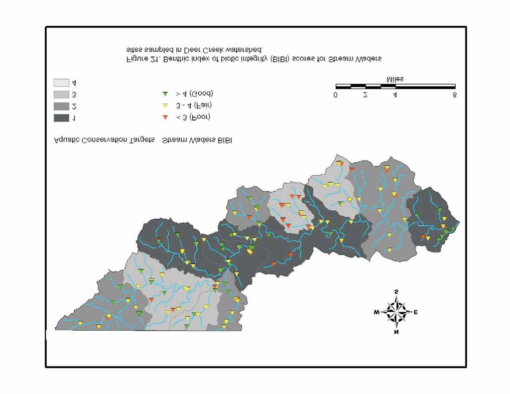
8 Deer Creek: Watershed Prioritization: Aquatic Conservation Targets: Aquatic Conservation Target 12-digit Watershed Streams in Aquatic Conservation Target Watershed Deer Creek mainstem/ Rock Hollow Branch/ Wet Stone Branch Little Deer Creek Deer Creek mainstem/ Saint Omer Branch Deer Creek mainstem at Susquehanna River confluence Falling Branch/ Deer Creek mainstem Deer Creek mainstem in Baltimore County Coolbranch Run/ Mill Brook/ Hopkins Branch/ Hollands Branch/ Deer Creek mainstem North Stirrup Run/ South Stirrup Run Big Branch Island Branch/ Jackson Branch/ Deer Creek mainstem Cabbage Run/ Stout Bottle Branch Thomas Run Deer Creek 12-digit sub-watersheds , , , and are designated as Aquatic Conservation Target One watersheds (Figure 1). It is recommended that protection and restoration be focused in these watersheds first to maintain populations of rare, threatened, or endangered aquatic species and/or good biological integrity. MDNR Natural Heritage Program s Ecologically Significant Areas depict lands within the Deer Creek watershed having important terrestrial biodiversity. ESAs should be used in conjunction with Aquatic Conservation Targets to focus protection and restoration to benefit terrestrial and aquatic biodiversity in Deer Creek (Figure 2). Characterization of stream conditions: A total of 75 MBSS sites were sampled in the Deer Creek watershed from 1994 to 2005 (Figure 3). An additional 171 Stream Waders sites were sampled in the Deer Creek watershed from 2000 to Select water quality, physical habitat, and land use variables that are useful indicators of anthropogenic influence at each MBSS site in Deer Creek are mapped (Figures 4-17). Measures of biological integrity (FIBI and BIBI) are also useful indicators of biological conditions as it relates to human disturbance. Biological integrity measured at MBSS and Stream Waders sites in Deer Creek are also mapped (Figures18-20). These maps depict site-specific data overlying the Aquatic Conservation Target sub-watersheds and should be useful in identifying problem areas and potential stressors to stream biota in these areas. The thresholds that were used for classifying values as good, fair, or poor on these figures are listed in Appendix A.
9 Probable Stressors to Fishes: The most prevalent stressors to fishes based on species absence where they were expected to occur in the Deer Creek watershed were high urban land use, high agriculture land use, and high nitrate concentrations. Stream bank erosion, acidic ph, introduced species, and low physical habitat scores were also identified as stressors to fishes in some streams (Figures 22-28). Prettyboy Reservoir: Watershed Prioritization: Aquatic Conservation Targets: Aquatic Conservation Target 12-digit Watershed Streams in Aquatic Conservation Target Watershed Compass Run/ PrettyBoy Reservoir/ Frog Hollow Cove Gunpowder Falls/ Muddy Run/ Walker run Grave Run/ Indian Run South Branch Gunpowder Falls Compass Run/ Georges Run/ Murphy Run/ Peggys Run The Prettyboy Reservoir 12-digit sub-watershed is designated as an Aquatic Conservation Target One watershed (Figure 29). It is recommended that protection and restoration be focused in this watershed first to maintain populations of rare, threatened, or endangered aquatic species and/or good biological integrity. MDNR Natural Heritage Program s Ecologically Significant Areas depict lands within the Prettyboy Reservoir watershed having important terrestrial biodiversity. ESAs should be used in conjunction with Aquatic Conservation Targets to focus protection and restoration to benefit terrestrial and aquatic biodiversity in the Prettyboy Reservoir watershed (Figure 30). Characterization of stream conditions: A total of 40 MBSS sites were sampled in the Prettyboy Reservoir watershed from 1996 to 2005 (Figure 31). An additional 16 Stream Waders sites were sampled in the watershed from 2000 to Select water quality, physical habitat, and land use variables that are useful indicators of anthropogenic influence at each MBSS site in Prettyboy Reservoir are mapped (Figures 32-46). Measures of biological integrity (FIBI and BIBI) are also useful indicators of biological conditions as it relates to human disturbance. Biological integrity measured at MBSS and Stream Waders sites in Prettyboy Reservoir are also mapped (Figures 47-49). These maps depict site-specific data overlying the Aquatic Conservation Target sub-watersheds and should be useful in identifying problem areas and potential stressors to stream biota in these areas. The thresholds that were used for classifying values as good, fair, or poor on these figures are listed in Appendix A.
10 Probable Stressors to Fishes: The most prevalent stressors to fishes based on species absence where they were expected to occur in the Prettyboy Reservoir watershed were high urban land use, high agriculture land use, high nitrate concentrations, low physical habitat quality, and stream bank erosion (Figures 50-54). Miles River: Watershed Prioritization: Aquatic Conservation Targets: Aquatic Conservation Target 12-digit Watershed Potts Mill Creek Potts Mill Creek Goldsborough Creek Glebe Creek Streams in Aquatic Conservation Target Watershed Black Duck Cove/ Gully Cove/ Miles River/ Potts Mill Creek Hunting Creek/ Leeds Creek/ Miles River/ Woodland Creek Grocelys Cove/ Hayward Cove/ Long Haul Creek/ Miles River/ Spencer Creek/ Oak Creek There are no Target One or Target Two watersheds in Miles River. Miles River 12-digit sub-watersheds and are designated as Aquatic Conservation Target Three watersheds (Figure 55). It is recommended that protection and restoration be focused in these Target Three watersheds first to maintain good biological integrity. MDNR Natural Heritage Program s Ecologically Significant Areas depict lands within the Miles River watershed having important terrestrial biodiversity. ESAs should be used in conjunction with Aquatic Conservation Targets to focus protection and restoration to benefit terrestrial and aquatic biodiversity in Miles River (Figure 56). Characterization of stream conditions: A total of 12 MBSS sites were sampled in the Miles River watershed from 2003 to 2005 (Figure 57). An additional 15 Stream Waders sites were sampled in the watershed in Select water quality, physical habitat, and land use variables that are useful indicators of anthropogenic influence at each MBSS site in Miles River are mapped (Figures 58-72). Measures of biological integrity (FIBI and BIBI) are also useful indicators of biological conditions as it relates to human disturbance. Biological integrity measured at MBSS and Stream Waders sites in Miles River are also mapped (Figures 73-
11 75). These maps depict site-specific data overlying the Aquatic Conservation Target subwatersheds and should be useful in identifying problem areas and potential stressors to stream biota in these areas. The thresholds that were used for classifying values as good, fair, or poor on these figures are listed in Appendix A. Probable Stressors to Fishes: The most prevalent stressors to fishes based on species absence where they were expected to occur in the Miles River watershed were high urban land use, acidic ph, and stream bank erosion (Figures 76-78). Port Tobacco River: Watershed Prioritization: Aquatic Conservation Targets: Aquatic Conservation Target 12-digit Watershed Streams in Aquatic Conservation Target Watershed Hoghole Run/ Port Tobacco Creek Port Tobacco River Jennie Run/ Port Tobacco Run/ Pages Swamp Wills Branch Wills Branch Port Tobacco River 12-digit sub-watersheds and are designated as Aquatic Conservation Target One watersheds (Figure 79). It is recommended that protection and restoration be focused in these watersheds first to maintain populations of rare, threatened, or endangered aquatic species and/or good biological integrity. MDNR Natural Heritage Program s Ecologically Significant Areas depict lands within the Port Tobacco River watershed having important terrestrial biodiversity. ESAs should be used in conjunction with Aquatic Conservation Targets to focus protection and restoration to benefit terrestrial and aquatic biodiversity in Port Tobacco River (Figure 80). Characterization of stream conditions: A total of 32 MBSS sites were sampled in the Port Tobacco River watershed from 2003 to 2005 (Figure 81). An additional 65 Stream Waders sites were sampled in the watershed from 2003 to Select water quality, physical habitat, and land use variables that are useful indicators of anthropogenic influence at each MBSS site in Port Tobacco River are mapped (Figures 82-96). Measures of biological integrity (FIBI and BIBI) are also useful indicators of biological conditions as it relates to human disturbance. Biological integrity measured at MBSS and Stream Waders sites in Port Tobacco River are also mapped (Figures 97-99). These maps depict site-specific data overlying the Aquatic Conservation Target sub-watersheds and should be useful in identifying problem areas and potential stressors to stream biota in these areas. The
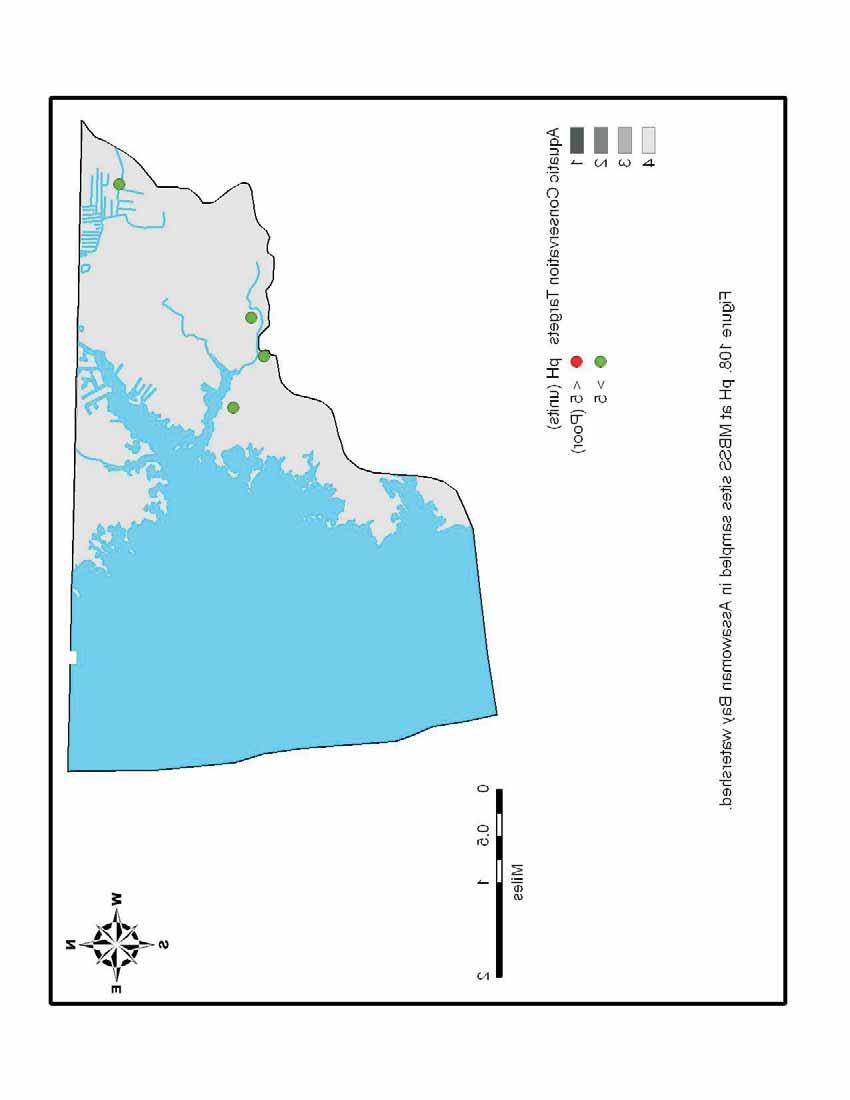
12 thresholds that were used for classifying values as good, fair, or poor on these figures are listed in Appendix A. Probable Stressors to Fishes: The most prevalent stressors to fishes based on species absence where they were expected to occur in the Port Tobacco River watershed were acidic ph, high urban land use, low physical habitat quality, and stream bank erosion (Figures ). Assawoman Bay: Watershed Prioritization: Aquatic Conservation Targets: Aquatic Conservation Target 12-digit Watershed Streams in Aquatic Conservation Target Watershed Montego Bay/ Caine Keys/ Bayside Keys Back Creek/ Greys Creek/ Goose Creek/ Peeks Creek There are no Target One, Target Two, or Target Three watersheds in the Assawoman Bay watershed. Assawoman Bay 12-digit sub-watersheds and are designated as Aquatic Conservation Target Four watersheds (Figure 104). Target Four watersheds are likely to benefit from any restoration effort. Historically, these areas most likely supported important components of Maryland s aquatic biodiversity and even incremental improvements in condition through restoration should result in improved biological health of these stream ecosystems. MDNR Natural Heritage Program s Ecologically Significant Areas depict lands within Assawoman Bay watershed having important terrestrial biodiversity. ESAs should be used in conjunction with Aquatic Conservation Targets to focus protection and restoration to benefit terrestrial and aquatic biodiversity in Assawoman Bay (Figure 105). Characterization of stream conditions: A total of four MBSS sites were sampled in the Assawoman Bay watershed in 2005 (Figure 106). There are no Stream Waders sites in this watershed. Select water quality, physical habitat, and land use variables that are useful indicators of anthropogenic influence at each MBSS site in Assawoman Bay are mapped (Figures ). Measures of biological integrity (FIBI and BIBI) are also useful indicators of biological conditions as it relates to human disturbance. Biological integrity measured at MBSS sites in Assawoman Bay are also mapped (Figures ). These maps depict sitespecific data overlying the Aquatic Conservation Target sub-watersheds and should be useful in identifying problem areas and potential stressors to stream biota in these areas.
13 The thresholds that were used for classifying values as good, fair, or poor on these figures are listed in Appendix A. Probable Stressors to Fishes: No specific stressors to fishes were identified in the Assawoman Bay watershed.
14 Literature Cited Barbour, M.T. and Stribling, J.B Biological Criteria: Research and Regulation. U.S. Environmental Protection Agency, Washington, D.C. Boward, D. and R. Bruckler Maryland Stream Waders Sample Year 2003 Report. Prepared by the Monitoring and Non-Tidal Assessment Division, Maryland Department of Natural Resources. Annapolis, MD. Kazyak, P.F Maryland Biological Stream Survey Sampling Manual. Prepared by the Monitoring and Non-Tidal Assessment Division, Maryland Department of Natural Resources. Annapolis, MD. MDNR Rare, Threatened, and Endangered Animals of Maryland. Prepared by Wildlife and Heritage Service, Natural Heritage Program, Maryland Department of Natural Resources. Annapolis, MD. MDNR Maryland Stream Waders volunteer stream monitoring manual. Maryland Department of Natural Resources. Monitoring and Non-tidal Assessment Division, Annapolis, Maryland. Ohio EPA Biological Criteria for the Protection of Aquatic Life. Ohio Environmental Protection Agency, Columbus, Ohio. Plafkin, J.L., Barbour, M.T., Porter, K.D., Gross, S.K., Hughes, R.M Rapid Bioassessment Protocols for Use in Streams and Rivers. U.S. Environmental Protection Agency, Washington, D.C. Roth, N., J. Volstad, L. Erb, E. Weber, P. Kazyak, S. Stranko, and D. Boward Maryland Biological Stream Survey Volume 6: Laboratory, Field, and Analytical Methods. Prepared for the Monitoring and Non-Tidal Assessment Division, Maryland Department of Natural Resources, Annapolis, MD CBWP- MANTA-EA Stranko, S., M.K. Hurd, and R.J. Klauda Applying a large, statewide database to the assessment, stressor diagnosis, and restoration of stream fish communities. Environmental Monitoring and Assessment 108: Southerland, M.T., M.J. Kline, D.M. Boward, G.M. Rogers, R.P. Morgan, P.F. Kazyak, R.J. Klaude, and S.A. Stranko New biological indicators to better assess the condition of Maryland streams. Prepared for the Monitoring and Non-Tidal Assessment Division, Maryland Department of Natural Resources, Annapolis, MD CBWP-MANTA-EA
15 Appendix A: Thresholds for classifying physical habitat, chemical, biological, and land use values as indicative of degradation or good quality. Biological Parameters Fish IBI Score: Fish Index of Biotic Integrity, scored on the following scale: Good Fair Poor/ Very Poor IBI Score IBI Score IBI Score Site is shaded red if FIBI score is <3.0. Site is shaded yellow if FIBI score is Site is shaded green if FIBI score is >4.0. Comparable to reference streams considered to be minimally impacted. Fall within the upper 50% of reference site conditions. Comparable to reference conditions, but some aspects of biological integrity may not resemble the qualities of these minimally impacted streams. Fall within the lower portion of the range of reference sites (10 th to 50 th percentile). Significant deviation from reference conditions, with many aspects of biological integrity not resembling the qualities of these minimally impacted streams, indicating severe degradation. Benthic IBI Score: Benthic Index of Biotic Integrity, scored on the following scale: Good Fair Poor/ Very Poor IBI Score IBI Score IBI Score Site is shaded red if BIBI score is <3.0. Site is shaded yellow if FIBI score is Site is shaded green if BIBI score is >4.0. Comparable to reference streams considered to be minimally impacted. Fall within the upper 50% of reference site conditions. Comparable to reference conditions, but some aspects of biological integrity may not resemble the qualities of these minimally impacted streams. Fall within the lower portion of the range of reference sites (10 th to 50 th percentile). Significant deviation from reference conditions, with many aspects of biological integrity not resembling the qualities of these minimally impacted streams, indicating severe degradation.
16 Water Quality Parameters NO 3 Nitrate Nitrogen (mg/l): Site is shaded red (excessive) if value is >5, orange (high) if value is between 3 and 5, yellow (moderate) if value is between 1 and 3, and green (baseline) if value is <1. Total Phosphorus (mg/l): Site is shaded red (high) if value is >0.07, yellow (moderate) if value is between and 0.07, and green (low) if value is < D.O. Dissolved Oxygen (mg/l): Site is shaded red if value is 5 mg/l water criterion (COMAR ). ph (units): Site is shaded red if value is < 5.0. ph less than 5.0 is considered harmful to stream biota, especially fish (COMAR ). Acid Neutralizing Capacity (µeq/l): Site is shaded red (highly sensitive to acidification) if value is <50, yellow (sensitive to acidification) if value is between 51 and 200, and green (not sensitive to acidification) if value is >200. Turbidity (NTU): Measurement of suspended solids. Site is shaded red (high) if value is 10, and green (low) if value is <10. Physical Habitat Parameters: Instream Habitat Quality: Measurement of habitat quality as it relates to stream fishes. Site is shaded red if value is < 6, yellow if value is between 6 and 15, and green if value is >15. Epifaunal Substrate Quality: Measurement of habitat quality as it relates to benthic macroinvertebrates. Site is shaded red if value is < 6, yellow if value is between 6 and 15, and green if value is >15. Stream Bank Stability: Measurement of severity of erosion and potential for erosion on both stream banks. Site is shaded red if value is < 6, yellow if value is between 6 and 15, and green if value is >15. Substrate Embeddedness (%): Measurement of percentage of stream substrate surrounded by fine sediments (sands and silts). Site is shaded red (high) if value is 100. Stream Temperature ( C): Use Class I (Water Contact Recreation) Waters: Site is shaded red if value is >32 C (COMAR ). Use Class III (Natural Trout) Waters: Site is shaded red if value is > 20.0 C (COMAR ). Use Class IV (Recreational Trout) Waters: Site is shaded red if value is > 23.9 C
17 (COMAR ). Land Use Parameters Riparian Buffer Width (meters): Site is shaded red if buffer width is <10 meters, yellow if buffer width is between 10 and 49 meters, and green if width is 50 meters. Impervious Land Cover (%): Percent impervious land cover in the upstream catchment of site. Site is shaded red (excessive) if value is > 10, yellow (moderate) if value is between 2 and 9, and green (low) if value is < 2. Urban Land use (%): Percent urban land cover in the upstream catchment of site. Site is shaded red if value is > 50, yellow if value is between 21 and 49, and green if value is 20. Agriculture Land Use (%): Percent agriculture land cover in the upstream catchment of site. Site is shaded red if value is > 75. Stressors to Stream Fishes: Fish species tolerances to MBSS variables as used in this report can be found in Stranko et al. (2005). These thresholds, in some cases, exceed thresholds used for water quality criteria. For example, ph values recorded at a site may be above the water quality criterion of 5.0, but may exceed threshold tolerances for a fish species.
18
19
20
21
22
23
24
25
26
27
28
29
30
31
32
33
34
35
36
37
38
39
40
41

42
43
44
45
46
47
48
49
50
51
52
53
54
55
56
57
58
59

60
61
62
63
64
65
66
67
68
69
70
71
72

73
74
75
76

77
78
79
80
81
82
83
84
85
86
87
88
89
90
91
92
93

94
95
96
97
98
99
100
101
102
103
104
105
106
107
108
109
110
111
112
113
114
115
116
117
118
119
120
121
122
123

124
125
126
127
128
129
130
131
132
133
134
135
136
137
138
139
140
141
DRAFT Introduction:
 Introduction: Bay Area Macroinvertebrate Bioassessment Information Network San Francisco Bay Area Creeks Benthic Index of Biotic Integrity (IBI) Draft IBI Workplan v.4 The following describes a series
Defining Biologically Relevant Thresholds for TN & TP in Coastal Bays Non-Tidal Streams
 Defining Biologically Relevant Thresholds for TN & TP in Coastal Bays Non-Tidal Streams Carol B. McCollough 1, Carol J. Cain 2 Roman Jesien 2 & Cathy Wazniak 1 1 MD-DNR RAS/TEA, 2 Maryland Coastal Bays
9. Evaluation Mechanisms
 9. Evaluation Mechanisms Not everything that can be counted counts, and not everything that counts can be counted. - Albert Einstein Introduction Watershed planning is meant to be an iterative process
MURPHY DRAIN CATCHMENT
 The RVCA produces individual reports for 16 catchments in the Lower Rideau subwatershed. Using data collected and analysed by the RVCA through its watershed monitoring and land cover classification programs,
Carp Creek 2013 Summary Report
 Monitoring Activity in the Carp River Watershed In 2012, Mississippi Valley Conservation Authority (MVCA) worked with Friends of the Carp River (FCR) on a preliminary assessment of the Carp River. This
Chapter Three: Discussion and Conclusion. 3.1 Introduction/Overview. 3.2 Countywide Stream Assessment
 3.1 Introduction/Overview The objective of this study was to develop a stream prioritization tool that evaluates stream reaches in terms of the potential water quality improvements that could be achieved
Technical Memorandum. Ipswich and Shawsheen River Watersheds 2005 Fish Population Monitoring and Assessment
 Technical Memorandum Ipswich and Shawsheen River Watersheds 2005 Fish Population Monitoring and Assessment Robert J. Maietta Massachusetts Department of Environmental Protection Division of Watershed Management
CITY OF GRIFFIN STREAM BANK RESTORATION PROGRAM
 CITY OF GRIFFIN STREAM BANK RESTORATION PROGRAM Lee Phillips 1, J. Erik Alford2 and M. Brad McLeod 3 AUTHORS: 'Project Engineer, Integrated Science & Engineering, 118 North Expressway, Griffin, GA 30223;
WATERSHED. Maitland Valley. Report Card 201
 Maitland Valley WATERSHED Report Card 201 The Maitland Valley Conservation Authority has prepared this report card as a summary on the state of our forests, wetlands, surface water, and ground water resources.
Biological Uplift in Stream Restoration Projects. September 20, Presentation by: Wetlands and Waterways Program
 Biological Uplift in Stream Restoration Projects September 20, 2017 Presentation by: Wetlands and Waterways Program Integrated Water Planning Program Maryland Department of the Environment Wetlands & Waterways
Maumee Area of Concern Water Quality Database Development
 Maumee Area of Concern Water Quality Database Development Project Overview Background In 1987 the Maumee Area of Concern (AOC) in northwest Ohio was designated as an Area of Concern based on the identification
Functional Uplift Based Stream Assessment & Restoration Design
 Functional Uplift Based Stream Assessment & Restoration Design Darcy K.L. Turner Senior Environmental Scientist, Biohabitats, Inc. (dturner@biohabitats.com) Christopher A. Streb, PE Ecological Engineer,
Eutrophication: Tracing Nutrient Pollution Back to Penns Creek
 Eutrophication: Tracing Nutrient Pollution Back to Penns Creek Nutrients are substances that life depends on for growth and reproduction. However, when these nutrients enter our planets waterways in excess,
INteractive STream Assessment Resource Biological Monitoring Program
 Page 1 of 9 INteractive STream Assessment Resource Biological Monitoring Program Thumbnail Not Available Tags WADEABLE STREAMS, Habitat, Watersheds, Streams, BENTHOS, Fish, biota, environment, Biology,
THE NORTH BRANCH OF THE POTOMAC RIVER: RESULTS OF TWO YEARS OF LIME DOSING
 THE NORTH BRANCH OF THE POTOMAC RIVER: RESULTS OF TWO YEARS OF LIME DOSING INTRODUCTION Joseph E. Mills Maryland Department of the Environment Bureau of Mines 160 S. Water Street Frostburg, Maryland 21532
Watts Creek 2014 Summary Report
 Monitoring Activity in the City of Ottawa In 2012, Mississippi Valley Conservation Authority (MVCA) and the Friends of the Carp River (FCR) collaborated to undertake a broad scale assessment of potential
Ontario Envirothon LEARNING OBJECTIVES. Ontario Envirothon Learning Objectives
 Ontario Envirothon LEARNING OBJECTIVES Updated Fall 2015 5 Contents Contents... 6 Overall Objectives... 7 Aquatic Ecology... 8 Specific Objectives... 8 Overall Objectives... 8 Application/Analysis... 9
Factsheet: Town of Deep River Water Quality and Stormwater Summary
 79 Elm Street Hartford, CT 06106-5127 www.ct.gov/deep Affirmative Action/Equal Opportunity Employer Factsheet: Town of Deep River Water Quality and Stormwater Summary This document was created for each
VIDEO: Riparian Forest Buffers: The Link Between Land & Water
 VIDEO: Riparian Forest Buffers: The Link Between Land & Water Introduction to Riparian Buffers Adapted from: Riparian Forest Buffers: The Link Between Land & Water. Maryland Cooperative Extension. Wye
A Summary Guide to the. Rifle River WATERSHED MANAGEMENT PLAN. Know Your Watershed Protect Its Resources
 A Summary Guide to the Rifle River WATERSHED MANAGEMENT PLAN Know Your Watershed Protect Its Resources Table of Contents The Watershed... 3 The Management Plan... 4 Designated and Desired Uses... 5 Sources
Large River Semi-wadeable MMI. Dustin Shull 2017
 Large River Semi-wadeable MMI Dustin Shull 2017 Tom Wolf, Governor 1 Patrick McDonnell, Secretary Introduction: Large Rivers Large Rivers > 1000 mi 2 Typically non-wadeable Lacking description in literature
The list of SGCN identified in the 2005 Kansas Comprehensive Wildlife Conservation Plan was revised according to the following decisions:
 Chapter 2 METHODS Photo Travis Taggart Overview This revision involved an evaluation and revision of the list of SGCN and habitats developed for the 2005 Kansas Comprehensive Wildlife Conservation Plan,
Riffle Beetles to Riparian Buffers
 We care about WateR. it S What We do. Riffle Beetles to Riparian Buffers Exploring Methods of Assessing Surface Water Quality Grade level: 7-12 objective: Students will evaluate the quality of two water
Linda Cooper, Eno River State Park, Durham, NC
 Linda Cooper, Eno River State Park, Durham, NC 2 Rivers and Streams All 50 states, 2 interstate river commissions, American Samoa, Guam, Puerto Rico, the District of Columbia (collectively referred to
Riparian Buffers and Stream Restoration
 Riparian Buffers and Stream Restoration Why focus on riparian areas? Link land and water on any given site and link landscapes together in a watershed Riparian corridors protect the circulatory system
Analysis of Ephemeroptera, Plecoptera and Trichoptera (EPT) richness and diversity of Guilford Creek, Guilford, NY
 richness and diversity of Guilford Creek, Guilford, NY") Analysis of Ephemeroptera, Plecoptera and Trichoptera (EPT) richness and diversity of Guilford Creek, Guilford, NY Peter Hazelton 1 ABSTRACT Analysis of a single kick sample from a 2 nd order stream in
Analysis of Ephemeroptera, Plecoptera and Trichoptera (EPT) richness and diversity of Guilford Creek, Guilford, NY Peter Hazelton 1 ABSTRACT Analysis of a single kick sample from a 2 nd order stream in
Habitat Grant Projects Clinton River Watershed
 Habitat Grant Projects Clinton River Watershed L Y N N E S E Y M O U R E N V I R O N M E N T A L E N G I N E E R O F F I C E O F T H E M A C O M B C O U N T Y P U B L I C W O R K S C O M M I S S I O N
Chapter 10 Natural Environment
 Chapter 10 Natural Environment Existing Conditions The Natural Environment Element addresses the protection, conservation, preservation, and restoration of the natural resources the Bayview Ridge Subarea,
Council of Governments
 Metropolitan Washington Council of Governments Anne Arundel County Draft Phase II Watershed Implementation Plan January 18, 2011 Chesapeake Bay TMDL Pollutants of Concern Nitrogen Phosphorus Sediment 2
Stream Observation Data Sheet School: Charleroi Middle School Date 9/24/15 Stream Study Site: Maple Creek. Macroinvertebrate Survey
 Stream Observation Data Sheet School: Charleroi Middle School Date 9/2/15 Stream Study Site: Maple Creek Teacher: Mr. Johnson Latitude_210 7 degrees NORTH Yesterday Group Members: Period 7 th Longitude_79
USING HYDROSCAPES TO MAXIMIZE THE BENEFITS OF RIPARIAN CORRIDOR RESTORATION FOR MULTIPLE RIVER ECOSYSTEM SERVICES
 REFORM International Conference on River and Stream Restoration Novel Approaches to Assess and Rehabilitate Modified Rivers TEMPLATE FOR EXTENDED SUMMARY USING HYDROSCAPES TO MAXIMIZE THE BENEFITS OF RIPARIAN
Stream Observation Data Sheet School CMS Date 12/16/2015 Stream Study Site Mingo Creek. Macroinvertebrate Survey
 Stream Observation Data Sheet School CMS Date 2/6/205 Stream Study Site Mingo Creek Teacher Johnson Group Members: Latitude degrees NORTH Yesterday Longitude degrees WEST Weather Today Air Temperature
TORCH LAKE TOWNSHIP WATER QUALITY ACTION PLAN
 TORCH LAKE TOWNSHIP WATER QUALITY ACTION PLAN Elk-River-Chain-of-Lakes Gaps Analysis Project The Watershed Center Grand Traverse Bay Tip of the Mitt Watershed Council Michigan Department of Natural Resources
Stream Watch Visual Survey Instructions
 Stream Watch Visual Survey Instructions The Stream Watch Visual Survey is based on assessment parameters from the EPA's Rapid Bioassessment Protocol Habitat Assessment, Georgia Adopt a Stream Visual Survey,
BIOLOGICAL AND GEOMORPHOLOGICAL CONDITION IN THE PICTURE SPRING BRANCH SUBWATERSHED, SEVERN RIVER WATERSHED, ANNE ARUNDEL COUNTY, MARYLAND:
 BIOLOGICAL AND GEOMORPHOLOGICAL CONDITION IN THE PICTURE SPRING BRANCH SUBWATERSHED, SEVERN RIVER WATERSHED, ANNE ARUNDEL COUNTY, MARYLAND: 2013-2014 Prepared for Anne Arundel County, Maryland Department
Construction of Artificial Riffles and Pools For Freshwater Habitat Restoration
 Construction of Artificial Riffles and Pools For Freshwater Habitat Restoration Kate Howe Preserving biodiversity is one of the central goals of ecologists and conservation biologists today. As human population
Municipal Stormwater Management Planning
 Municipal Stormwater Management Planning Christopher C. Obropta, Ph.D., P.E. Water Resources Extension Specialist with Rutgers Cooperative Extension Assistant Professor with Department of Environmental
3 Objectives 3 Ob jec tives
 3 Objectives 3 Objectives 3 Objectives 3 Objectives contents Objective number Page 3.1 Ki uta ki tai: mountains to the sea O1-O5 37 3.2 Beneficial use and development O6-O13 38 3.3 Māori relationships
Index of Watershed Indicators: An Overview
 Index of Watershed Indicators: An Overview U.S. Environmental Protection Agency Office of Wetlands, Oceans, and Watersheds Table of Contents Introduction...1 Questions and Answers...3 Flow Charts for the
Lisa Hauck Stream Restoration May
 The Effects of Stream Restoration on Habitat Quality Lisa Hauck Abstract Many stream restoration projects do not include a requirement for long-term monitoring after the project has been completed, resulting
Amanda Deal & Len Lichvar Somerset Conservation District
 Stonycreek River Watershed Reassessment Amanda Deal & Len Lichvar Somerset Conservation District August 2008 Watershed Characteristics ti 298,920 acres 538 perennial stream miles 519 mi natural stream/river
Rewards, Challenges, Approaches and Solutions for Developing the Soos Creek Bioassessment TMDL
 Western Washington University Western CEDAR Salish Sea Ecosystem Conference 2014 Salish Sea Ecosystem Conference (Seattle) May 1st, 10:30 AM - 12:00 PM Rewards, Challenges, Approaches and Solutions for
 Good Morning! Bruce Gilman Department of Environmental Conservation and Horticulture Finger Lakes Community College 3325 Marvin Sands Drive Canandaigua, New York 14424 585-785- 1255 gilmanba@flcc.edu Northern
PLANT AND ANIMAL DIVERSITY
 by the planning rule team as of. These ideas are for discussion purposes and do not What we want to achieve PLANT AND ANIMAL DIVERSITY The Forest Service is committed to protecting species and sustaining
Comparison of Total Phosphorus and Macro Invertebrates and the Impact of Land Use on Water Quality. Laura Roldán Isardo Braverman Puerto Rico
 Comparison of Total Phosphorus and Macro Invertebrates and the Impact of Land Use on Water Quality Laura Roldán Isardo Braverman Puerto Rico The Streams Project The Streams Project is an effort by VT EPSCoR
Estero Americano Watershed Sediment Reduction Project, Phase II, Sonoma and Marin Counties, CA. Draft Quarterly Monitoring Report Item B.4.
 Estero Americano Watershed Sediment Reduction Project, Phase II, Sonoma and Marin Counties, CA Draft Quarterly Monitoring Report Item B.4.2 This quarterly report summarizes data collected from December
Shannon-Wiener Diversity Index: A measure of the taxonomic diversity of the community. Index value decreases with increasing stress.
 Benthic macroinvertebrate samples were analyzed using seven metrics mainly derived from RBP III (Barbour and others, 1999): (1) taxonomic richness; (2) modified Hilsenhoff Biotic Index; (3) percent Ephemeroptera;
BIG ROCHE A CRI LAKE CHARACTERISTICS
 BIG ROCHE A CRI LAKE CHARACTERISTICS Lake Description Big Roche Cri Lake is located in north central Adams County and has a surface area of 205 acres, a shoreline length of 6.1 mile, a volume of 6,993
A Freshwater Blueprint for Maritime Canada
 A Freshwater Blueprint for Maritime Canada Union of Nova Scotia Municipalities (UNSM) November 8 th, 2017 William Millar Aquatic Conservation Biologist william.millar@natureconservancy.ca Craig Smith Conservation
A Multimetric Benthic Macroinvertebrate Index for the Assessment of Stream Biotic Integrity in Korea
 Int. J. Environ. Res. Public Health 2012, 9, 3599-3628; doi:10.3390/ijerph9103599 OPEN ACCESS Article International Journal of Environmental Research and Public Health ISSN 1660-4601 www.mdpi.com/journal/ijerph
Ecosystem Service Tradeoffs in the Implementation of the Bay TMDL
 Ecosystem Service Tradeoffs in the Implementation of the Bay TMDL Lisa A. Wainger 1 and Jay Messer 2 1 University of Maryland Center for Environmental Science 2 Retired; formerly of US EPA Office of Research
Modeling Fate and Effects of Multiple Stressors on a Use- Impaired River
 Society for Environmental Toxicology & Chemistry Salt Lake City, Utah, November 18, 2002 Modeling Fate and Effects of Multiple Stressors on a Use- Impaired River Abstract Modeling the Effects of Multiple
CORSICA RIVER PRELIMINARY WATERSHED AUDIT. Opportunities To Build Upon A Highly Successful Watershed Restoration Campaign CORSICA RIVER CONSERVANCY
 CORSICA RIVER PRELIMINARY WATERSHED AUDIT Opportunities To Build Upon A Highly Successful Watershed Restoration Campaign Prepared By Richard Klein COMMUNITY & ENVIRONMENTAL DEFENSE SERVICES 811 Crystal
MARK CREEK DEMONSTRATION PROJECT
 MARK CREEK DEMONSTRATION PROJECT OCC Tasks 20 and 21 FY 1990 319(h) Task 210 EPA Grant # C9-006704-90-0 Submitted by: Oklahoma Conservation Commission Water Quality Division 413 NW 12 th Oklahoma City,
Alberta Wetland Policy
 Table of Contents Alberta Wetland Policy Overview...2 Acknowledgements...3 Wetlands in Alberta...4 The Need for a New Provincial Wetland Policy...5 Policy Context...6 Policy Scope...7 Policy Goal and Outcomes...8
EXISTING AND READILY AVAILABLE DATA
 EXISTING AND READILY AVAILABLE DATA The Bureau of Clean Water s Water Quality Division is seeking data for consideration in the 2018 303(d) assessment process. Data will be accepted until September 30
Project Goals and Scoping
 Prepared for: Boulder County, Colorado Flood Planning & Preliminary Design Services for South St. Vrain Creek Restoration at Hall Ranch and Scoping May 24, 2016 Meeting with General Public In association
South St. Vrain / Hall Meadows Restoration Planning August 20, 2015
 South St. Vrain / Hall Meadows Restoration Planning August 20, 2015 Agenda Introductions Purpose & Goals of Meeting Planning Area Master Plan Restoration Planning: Cost Estimates, Grants, Scope, Timeline
Environment & Conservation Introduction
 Environment & Conservation Introduction Anacortes is blessed with an abundance of natural beauty. Residents identify marine shorelines, streams, lakes, forested areas, and other natural features as defining
MiCorps 101. Presented by Paul Steen. & MiCorps Staff
 MiCorps 101 Presented by Paul Steen & MiCorps Staff MiCorps Team Bill Dimond Laura Kaminski Anne Sturm Dina Klemens Paul Steen, Ph.D. Jason Frenzel Scott Brown Jean Roth Jo Latimore, Ph.D. Together, we
BUCK HILL CREEK MONROE COUNTY WATER QUALITY STANDARDS REVIEW STREAM REDESIGNATION EVALUATION REPORT SEGMENT: BASIN STREAM CODE: 05023
 BUCK HILL CREEK MONROE COUNTY WATER QUALITY STANDARDS REVIEW STREAM REDESIGNATION EVALUATION REPORT SEGMENT: BASIN STREAM CODE: 05023 DRAINAGE LIST: C WATER QUALITY MONITORING SECTION (DSB) DIVISION OF
Macroinvertebrates as bioindicators
 Macroinvertebrates as bioindicators Now that you have collected a standardized sample of the stream benthic community, we will now evaluate that sample to calculate an Index of Biotic Integrity (IBI).
Rare Beauty: Volunteers Monitor Swamp Pink
 Rare Beauty: Volunteers Monitor Swamp Pink Citizens United, a local watershed organization in southern New Jersey, works in cooperation with the federal government to protect a rare species, swamp pink.
Public Notice. Applicant: City of Dallas Project No.: SWF Date: April 18, Name: Chandler Peter Phone Number:
 Public Notice Applicant: City of Dallas Project No.: SWF- 2014-00151 Date: April 18, 2014 The purpose of this public notice is to inform you of a proposal for work in which you might be interested. It
MARINE POLLUTION DEGRADATION MITIGATION MANAGEMENT IS ESSENTIAL FOR IMPROVING MARINE ENVIRONMENT
 MARINE POLLUTION DEGRADATION MITIGATION MANAGEMENT IS ESSENTIAL FOR IMPROVING MARINE ENVIRONMENT The health of the world s oceans and marine life is degrading rapidly as a result of excess human activities.
Chapter 13: Wildlife and Vegetation
 Chapter 13: Wildlife and Vegetation Introduction and Setting Nevada County contains an extremely wide range of plants, animals and habitat types. With topographic elevations ranging from 300 feet in the
Wisconsin s Green Fire: Voices for Conservation
 Analysis of proposal to remove state regulatory oversight of non-federal wetlands in legislation: AB547 / SB600 December 18, 2017 Legislation Description: The following is an excerpt of the analysis of
Maryland s Living Shorelines Program. Bhaskaran Subramanian February 27, 2015
 Maryland s Living Shorelines Program Bhaskaran Subramanian February 27, 2015 1 Erosion & traditional approaches Living shorelines- what is it? Maryland s Living Shorelines program LS Law Products Funding-
Appendix D3. Aquatic Resources. Tennessee Valley Authority Reservoir Operations Study Final Programmatic EIS
 Tennessee Valley Authority Reservoir Operations Study Final Programmatic EIS This page intentionally left blank. D3.1 Fish Index of Biotic Integrity (Used in Tailwaters)... D3-1 D3.2 Benthic Index of Biotic
Decision Rationale. Total Maximum Daily Load for Phosphorus for the Sassafras River, Cecil and Kent Counties, Maryland 4/1/2002
 Decision Rationale I. Introduction Total Maximum Daily Load for Phosphorus for the Sassafras River, Cecil and Kent Counties, Maryland 4/1/2002 The Clean Water Act (CWA) requires a Total Maximum Daily Load
Susquehanna River Smallmouth Bass Disease Investigation
 Susquehanna River Smallmouth Bass Disease Investigation May 9, 2013 Dial-in number for Audio: 1-877-668-4493 Event Number: 647 572 664 WebEx Technical Support: 866-229-3239 Note: You will not hear any
DECISION MEMO. West Fork Blacktail Deer Creek Hardened Crossing
 Page 1 of 6 Background DECISION MEMO USDA Forest Service Madison Ranger District Madison County T12S, R4W, Section 30 The project is in the Gravelly Landscape, Snowcrest Recommended Wilderness Management
AP Environmental Science
 AP Environmental Science Types of aquatic life zones MARINE Estuaries coral reefs mangrove swamps neritic zone pelagic zone FRESHWATER lakes and ponds streams and rivers wetlands Distribution of aquatic
Pacific Northwest Region, Forest Service Basin-scale Restoration Prioritization Process
 Pacific Northwest Region, Forest Service Basin-scale Restoration Prioritization Process Pacific Northwest Region U.S.D.A. Forest Service Dave Heller, Regional Fish Program Leader Bruce McCammon, Regional
STREAM AND BUFFER AREA PROTECTION/RESTORATION
 STREAM AND BUFFER AREA PROTECTION/RESTORATION AMENDMENT OPTIONS TO STRENGTHEN POLICY IN HEADWATERS AREAS DRAFT SUBSEQUENT TO THE JANUARY 25, 2007 MEETING OF THE PLANNING COMMISSION ENVIRONMENT COMMITTEE
Natural Resources and Climate Resiliency in Germantown
 Natural Resources and Climate Resiliency in Germantown Ingrid Haeckel, Andrew Meyer, and Elizabeth Murphy NYSDEC Hudson River Estuary Program and Cornell University Presentation to the Town of Germantown,
AGRICULTURAL WATER QUALITY INDEX
 Grand Valley State University ScholarWorks@GVSU Scientific Technical Reports Annis Water Resources Institute 1-1998 AGRICULTURAL WATER QUALITY INDEX Jeffrey Cooper Robert B. Annis Water Resources Institute
Quantifying the Benefits of Stream Restoration
 Quantifying the Benefits of Stream Restoration 10 th Annual GAFM Technical Conference, March 2016 Jarrod Karl, Hazen and Sawyer Presentation Outline Benefits of Stream Restoration The Watershed Approach
How Sensitive Are They?
 Pollution Tolerance Levels How Sensitive Are They? Adapted from: An original Creek Connections activity. Creek Connections, Box 10, Allegheny College, Meadville, Pennsylvania 16335. Grade Level: intermediate
Water Resources Element Appendix
 Appendix Housing Unit Projection Methodology The following assumptions were used to develop the housing unit projections for each Water Resources Element. All projections described in the and this Appendix
Wisconsin Wastewater Operators Association. Protecting Our Water Resources: The Future Bill Hafs - NEW Water 10/2014
 Wisconsin Wastewater Operators Association Protecting Our Water Resources: The Future Bill Hafs - NEW Water 10/2014 The Fox River Contributes 1/3 of All Nutrients to Lake Michigan APRIL 15, 2011 Photo
C O M P R E H E N S I V E P R O T E C T I O N & R E S T O R AT I O N P L A N. f or th e
 C O M P R E H E N S I V E P R O T E C T I O N & R E S T O R AT I O N P L A N f or th e R O S S B A R NE T T R E SERV O I R WATERS HED, MI S S I S S I P P I E X E C U T I V E S U M M A R Y O C T O B E R
CHESAPEAKE CLEANING UP THE THE ECONOMIC BENEFITS OF A VALUATION OF THE NATURAL BENEFITS GAINED BY IMPLEMENTING THE CHESAPEAKE CLEAN WATER BLUEPRINT
 OCTOBER 2014 THE ECONOMIC BENEFITS OF CLEANING UP THE CHESAPEAKE A VALUATION OF THE NATURAL BENEFITS GAINED BY IMPLEMENTING THE CHESAPEAKE CLEAN WATER BLUEPRINT The Chesapeake Bay Foundation gratefully
WATERSHED MANAGEMENT INITIATIVE: GOALS & IMPLEMENTATION OBJECTIVES, JULY 26, 1999
 WATERSHED MANAGEMENT INITIATIVE: GOALS & IMPLEMENTATION OBJECTIVES, JULY 26, 1999 The following table indicates the draft goals and objectives for the Santa Clara Basin WMI process. The overall objectives
National Environmental Standards for Plantation Forestry. Overview of the regulations
 National Environmental Standards for Plantation Forestry Overview of the regulations New national rules for plantation forestry Plantation forestry is New Zealand s third largest primary sector. It delivers
A Report on Existing and Possible Tree Canopy in the City of Charlotte and Mecklenburg County, NC
 A Report on Existing and Possible Tree Canopy in the City of Charlotte and Mecklenburg County, NC Why is Tree Canopy Important? Tree canopy (TC) is the layer of leaves, branches, and stems of trees that
DECISION NOTICE FINDING OF NO SIGNIFICANT IMPACT (FONSI)
") DECISION NOTICE AND FINDING OF NO SIGNIFICANT IMPACT (FONSI) FOR CASA LOMA RECREATION RESIDENCE PERMIT RENEWAL U.S. FOREST SERVICE CIBOLA NATIONAL FOREST SANDIA RANGER DISTRICT BERNALILLO COUNTY, NEW MEXICO
DECISION NOTICE AND FINDING OF NO SIGNIFICANT IMPACT (FONSI) FOR CASA LOMA RECREATION RESIDENCE PERMIT RENEWAL U.S. FOREST SERVICE CIBOLA NATIONAL FOREST SANDIA RANGER DISTRICT BERNALILLO COUNTY, NEW MEXICO
Portage Lake Hubbard County
 Prepared in cooperation with the Minnesota Department of Natural Resources Minnesota Lake ID: 9- Area: acres Watershed Area: 6,7 acres Ecoregion: Northern Lakes and Forests (NLF) Portage Lake Hubbard County
12/9/2011. Constructed Wetlands. Functions, Design Criteria
 Constructed Wetlands Functions, Design Criteria 1 2 Functions of Wetlands Flood mitigation Water filtration/purification (treatment) Wildlife habitat, biodiversity Biogeochemical cycles Recreation Reasons
Climate Change: Impacts, Monitoring, and Solutions
 Climate Change: Impacts, Monitoring, and Solutions 1 Responding to Climate Change 1. Projections/Impacts 2. Adaptation and Resiliency 3. Monitoring 4. What about emissions? 2 Native trout and salmon are
The total population of the township is 9,942 (2015 Five-Year American Community Survey [ACS]). The median household income is over $109,000.
![The total population of the township is 9,942 (2015 Five-Year American Community Survey [ACS]). The median household income is over $109,000.](/thumbs/72/67990406.jpg "The total population of the township is 9,942 (2015 Five-Year American Community Survey [ACS]). The median household income is over $109,000.") East Bradford Township, Pennsylvania Motivated by watershed impairment caused by suburban development over the past 30 years, a township with a full slate of water quality improvement programs looks outside
East Bradford Township, Pennsylvania Motivated by watershed impairment caused by suburban development over the past 30 years, a township with a full slate of water quality improvement programs looks outside
Highlands Environmental Resource Inventory for the [insert municipality name]tewksbury Township
![Highlands Environmental Resource Inventory for the [insert municipality name]tewksbury Township](/thumbs/72/66861609.jpg "Highlands Environmental Resource Inventory for the [insert municipality name]tewksbury Township") Highlands Environmental Resource Inventory for the [insert municipality name]tewksbury Township 2009 This Module 4 Highlands ERI for Tewksbury Township was completed by Kratzer Environmental Services using
Highlands Environmental Resource Inventory for the [insert municipality name]tewksbury Township 2009 This Module 4 Highlands ERI for Tewksbury Township was completed by Kratzer Environmental Services using
Truckee River Watershed Council 2016 Annual Monitoring Data Report April 25, 2017
 Truckee River Watershed Council 216 Annual Monitoring Data Report April 25, 217 i Executive Summary The Truckee River Watershed Council (TRWC) has maintained a volunteer-based water quality monitoring
Past experience in Arkansas Sally Entrekin University of Central Arkansas
 Past experience in Arkansas Sally Entrekin University of Central Arkansas Collaborators Funding through Arkansas Game and Fish Commission State Wildlife Grant # 223017 & 223023 University of Central Arkansas,
MONITORING QUESTIONS AND TASKS FOR THE GEORGE WASHINGTON PLAN
 MONITORING QUESTIONS AND TASKS FOR THE GEORGE WASHINGTON PLAN MONITORING THEME 1 CONSERVATION OF BIOLOGICAL DIVERSITY FOR ECOSYSTEMS MQ 1: How are ecological conditions maintaining or making progress toward
VILLAGE OF BELLAIRE WATER QUALITY ACTION PLAN
 VILLAGE OF BELLAIRE WATER QUALITY ACTION PLAN Elk-River-Chain-of-Lakes Gaps Analysis Project The Watershed Center Grand Traverse Bay Tip of the Mitt Watershed Council Michigan Department of Natural Resources
Avista Dam Relicensing Factsheet Commenting on the Draft License Application
 Avista Dam Relicensing Factsheet Commenting on the Draft License Application Please Note: This is intended for informational purposes only and does not constitute legal advice. The life of every river
Duwamish Waterway Self Guided Tour: Turning Basin Number Three and Terminal 105 Aquatic Habitat Restoration Sites
 Duwamish Waterway Self Guided Tour: Turning Basin Number Three and Terminal 105 Aquatic Habitat Restoration Sites Text and illustrations in the following pages include: (1) summary information describing
ENVIRONMENT. Subregion 6 Approved Master Plan and Sectional Map Amendment
 ENVIRONMENT Subregion 6 Approved Master Plan and Sectional Map Amendment Subregion 6 contains environmental assets of county, state, and even national importance, particularly near and along the Patuxent
Department of the Army Permit Application
 Department of the Army Permit Application DA File Number U.S. Army Corps of Engineers Honolulu District Date Received by CEPOH-RO Send Completed Application to: Honolulu District, U.S. Army Corps of Engineers