PRENTISS CREEK (SUB-E) KENSINGTON PLACE CONCEPT PLAN VILLAGE OF DOWNERS GROVE, ILLINOIS AUGUST, 2011
|
|
|
- Avis Stafford
- 6 years ago
- Views:
Transcription


1 PRENTISS CREEK (SUB-E) KENSINGTON PLACE CONCEPT PLAN VILLAGE OF DOWNERS GROVE, ILLINOIS AUGUST, 2011 Submitted to: NATHANIEL HAWK, STAFF ENGINEER VILLAGE OF DOWNERS GROVE 5101 WALNUT AVENUE DOWNERS GROVE, IL Prepared By:
2 2 MAKING A DIFFERENCE FOR STREAMS, RIVERS & LAKES Stream Restoration Lake and Wetland Management Water Quality Control Stormwater Engineering August 29, 2011 Nathaniel Hawk Staff Engineer Village of Downers Grove 5101 Walnut Avenue Downers Grove, IL60515 Re: PRENTISS CREEK (SUB E) - KENSINGTON PLACE CONCEPT PLAN Village of Downers Grove Dear Mr. Hawk: Thank you for the opportunity to submit this Prentiss Creek (Sub E) Kensington Place Concept Plan to the Village of Downers Grove. The Prentiss Creek Project Site includes approximately 730 LF of stream channel and on-line impoundment area along Prentiss Creek. Three (3) Options have been provided that would enhance existing conditions. These Options range from 1) Dredging, 2) Shoreline Stabilization, and 3) Dam Removal with Stream and Wetland Restoration. These Options differ based on long-term cost effectiveness, whether or not they include an environmentally sound approach, and the degree to which water quality control, recreational opportunity, aesthetic value, wildlife benefits, and other objectives are provided. Based on all factors considered, we recommend either Option # 3a or # 3b Dam Removal and Stream Restoration, or a combination of options including Dam Removal and Stream Restoration (such as # 4a or Option # 4b) be provided. Please contact me at to answer any questions or to set up a meeting to discuss steps towards possible implementation. Best Regards, Ted Gray, PE, CFM, CPESC Eco-Hydrologist & Engineer
3 3 Background: The Village of Downers Grove (Village) is evaluating potential alternatives to provide long-term, cost-effective improvements for existing on-line impoundment facility located along Prentiss Creek in the Kensington Place Subdivision east of Woodward Avenue and south of Loomes Avenue (Project Site). Site impacts at the Project Site include sediment deposition, mud flats, low water levels and other undesirable conditions. The Village of Downers Grove is working with the homeowners associations at the Project Site, as well as adjacent properties, to review alternative improvement options and recommendations. Three Options were evaluated for the Project Site: Option # 1: Dredging and Sediment Removal, Option # 2: Bank Stabilization / Shoreline Enhancement, and Option # 3: Dam Removal with Stream and Wetland Restoration. This Narrative Report describes the Project Site, site impacts, causes and sources of impacts, a description of each option, as well as advantages, disadvantages, costs, and permit considerations for each option. Project Area Description: Prentiss Creek Watershed Prentiss Creek flows through Downers Grove, DuPage County, Illinois (Fig. 1). The stream flows from east to west as an intermittent channel. The entire length of the stream channel through Woodward Avenue is approximately 0.85 miles in length. The watershed area through the Project Site is approximately 3.9 square miles in area. Most of the watershed is developed. Land uses include residential, commercial, industrial, and open space. Prentiss Creek has been channelized upstream of the Project Site, at least since 1939 (see Fig. 2). Prior to agricultural development, the pre-settlement vegetation type was dominated by prairie. Downstream of the Project Site, Prentiss Creek flows through Woodridge and then through the Green Valley Forest Preserve. Prentiss Creek then discharges into the East Branch DuPage River.


4 4 PROJECT SITE Fig. 1. Prentiss Creek sub-watershed boundary area and Project Site. The Project Site is located upstream of Woodward Avenue, south of 63 rd Street, and west of Prentiss Drive. The watershed area draining to the Project Site is approximately 3.9 square miles. Most of the watershed is urbanized. PROJECT SITE 1939 Fig. 2: 1939 aerial photograph of the Project site. East of Woodward Avenue, the stream had been channelized. West of Woodward Avenue, meanders occurred. Pre-settlement vegetation was prairie.

. 1974 Fig.")
 also occurred upstream of the impoundment. 2011 Fig.")
5 5 Project Site The proposed Project Site is located between Woodward Avenue to the west and downstream of Prentiss Drive. The riparian corridor at the Project Site is owned by the Village of Downers Grove and by the homeowners associations. The water surface area within the existing impoundment at the Project Site is approximately 1 acre in surface area. The length of stream channel within the impounded portion of the Project Site is approximately 730 linear feet (see also Concept Plans) Fig. 3: The 1974 aerial photograph depicts local development and the on-line impoundment. A small impounded area (depicted by arrow) also occurred upstream of the impoundment Fig. 4: By 2011, it is estimated that 3,000 cubic yards of silt became deposited in the impoundment. Existing water depths are typically 0.5 feet or less, due to the accumulation of silt. Algae blooms are visible (source: Google). By 2011, the small impounded area (see arrow) was also filled with silt.
. 4-FT+ Water Depths Fig.")
6 6 Based on available aerial photographs, the impoundment was created between 1961 and Based on past topographic map information, water depths when the impoundment was constructed may have been 4 feet or deeper (Fig. 5). 4-FT+ Water Depths Fig. 5: Based on past topographic information, there are indications that water depths within the impoundment were 4 feet or deeper. By 2011 average water depths are reduced to 0.5 feet or lower (Photo 1). Since construction of the impoundment, large accumulations of silt have become deposited. Based on existing thickness of silt deposits, as well as past topographic maps, it is possible that approximately 3,000 cubic yards of silt have been deposited in the impounded area. Photo 1: Existing (2011) site conditions include silt deposits, aesthetic impacts, aquatic habitat impacts, and nuisance algae blooms. (Photo from Woodward Avenue, facing east.)


7 Resulting problems at the Project Site have included water quality impacts due to silt deposition, aesthetic impacts, degradation of aquatic habitat, nuisance algae blooms, odors due to extensive silt deposits, lack of dissolved oxygen, and other factors. 7 Photo 2: Silt deposits within the impoundment become exposed during water drawdown events. (Photo from east impoundment area, facing west Woodward Avenue in background.) Photo 3: The existing outlet structure at Woodward Avenue raises the water level to allow the impoundment to form. But this also reduces stream slope and acts to trap silt within the impounded area. These types of structures are also a barrier to fish migration from downstream areas. Causes of Problems: Causes of existing problems include the following. Streams convey both sediment and water as a natural process. However, on-line impoundments, such as Prentiss Creek at Kensington (Sub E), not only reduce the stream slope, but they also substantially reduce water velocity. As a result, sediment particles are no longer
 become deposited at the upstream end of an impoundment.")
8 conveyed, but they settle out of the water column and become deposited on the bottom of the impoundment. Due to an inability to generate scouring velocities, sediment deposits remain onsite. Typically heavier sediment particles (gravel and sand) become deposited at the upstream end of an impoundment. Lighter particles that remain suspended for a longer time period (silts and clays) become deposited farther downstream within the impoundment. These sediment deposition patterns have been observed at the Project Site. The stream channel upstream of the impoundment contains cobble and gravel materials on the stream channel bottom. As the impoundment is approached, smaller particles (sand) becomes predominant. Farther downstream within the impoundment, silt and clay deposition is common. The top of the sediment is covered by an organic matrix, due in part to decaying algae. According to available topographic data, the stream profile upstream of Woodward Avenue is approximately ft/ft. This represents a fall of approximately 0.38 ft for each 100 ft of longitudinal distance. In contrast, the slope within the impounded area is only approximately ft/ft. This is 400% reduction in slope compared with the free-flowing stream channel. Downstream of Woodward Avenue the stream slope is 800% higher (fall of 0.7 ft per 100 ft of longitudinal distance) compared with the impounded area. The low slope at the impoundment increases the efficiency with which the existing impoundment traps sediment transported from upstream areas. 8 Fig. 6: According to the DuPage County Soil Survey, the local soil type at the Project Site is Orthents, clayey, undulating. Clay soils are typically more resistant to erosion than other soil types, such as loam. However, even clay soils are subject to shoreline or streambank erosion. Sources of sediment flowing into the impoundment include the following. Severe streambank erosion was noted along the inlet channel that flows into the

 of inflowing sediment into the impoundment, each year.")
9 impoundment from Loomes Avenue. According to the U.S. Geological Survey, up to 50% of the inflowing silt can originate from streambank erosion. In addition to this source of silt, washoff of solids can occur from sewered roads, parking lots, rooftops, commercial/industrial areas, and other urban areas of the watershed. In addition, onsite algae blooms contribute to decaying organic matter that contributes to filling of the impoundment. According to methods by Illinois EPA, it is possible that the 3.9 square mile watershed may contribute up to 750 cubic yards (wet volume) of inflowing sediment into the impoundment, each year. If this entire volume were deposited, this represents enough silt to fill up the available storage capacity of the impoundment within just a 4-year time period. When an impoundment is excavated, the efficiency for trapping sediment only increases. Therefore, even if the impoundment were re-excavated, it is likely the dredged volume would re-fill with silt perhaps within just several years. 9 Photo 3: Existing severe streambank erosion observed along the inlet channel that flows from near Loomes Avenue into the impoundment. In some watersheds, up to 50% of the inflowing sediment can be attributed to streambank erosion. Watershed development such as the installation of impervious surfaces as well as storm sewer systems has substantially contributed to existing degraded conditions at the Project Site. For instance, urbanization of the watershed reduces water levels during dry-season conditions. Drawdown of water levels contributes to exposing large mud flat deposits during low-water periods. This can occur because urbanization reduces the amount of rainfall that can infiltrate into the ground, thereby reducing replenishment of subsurface groundwater supplies. Without sufficient groundwater, stream flow and water depths can become so low that they threaten aquatic life present in the stream. The impounded conditions also worsen
10 water quality by raising water temperatures, reducing dissolved oxygen, and reducing desirable aquatic habitat for stream-dwelling species. 10 Proposed Alternative Solutions: Three alternative solutions were evaluated for Prentiss Creek at Kensington Place (Sub E). These alternatives included: 1) Dredging for Sediment Removal, 2) Bank Stabilization / Shoreline Enhancement, and 3) Dam Removal with Stream and Wetland Restoration. A description of each proposed alternative is as follows. Option 1: Dredging for Sediment Removal Option 1 Dredging for Sediment Removal was evaluated. It was assumed that enough sediment removal would be provided to maintain an average water depth of 2 feet in the approximately 1-acre impounded area. It is estimated that at least 3,000 cubic yards of sediment would need to removed in order to accomplish this objective. As a second option, over 5,500 cubic yards of sediment was evaluated for removal to provide an average 3.5 foot depth in the impoundment. In either case, it is likely that a safety shelf would need to be installed around the perimeter of the pond. Advantages: - Returns water depths to past conditions - Large area of open water for those wanting the historic condition - If permit agencies consider the site to be a detention facility, then dredging may be considered a maintenance project which can reduce permitting requirements. - Construction of the Sediment Forebay upstream of the impoundment will assist with trapping sediment from upstream areas before it enters the impoundment.
11 11 Disadvantages: - High long-term costs, since sediment deposition will continue to occur, necessitating probable future re-dredging. - Dredging is a temporary, costly solution. For instance, according to methods by Illinois EPA, it is possible that the 3.9 square mile watershed may contribute up to 750 cubic yards (wet volume) of inflowing sediment into the impoundment, each year. If this entire volume were deposited, this represents enough silt to fill up the available storage capacity of the impoundment within just a 4-year time period. When an impoundment is excavated, the efficiency for trapping sediment only increases. Therefore, even if the impoundment were re-excavated, it is likely the dredged volume would re-fill with silt perhaps within just several years. - Does not address impacts to water quality or impacts to aquatic life caused by on-line impoundments - If sediment toxicity is present, it may escalate disposal costs, permitting requirements, and/or permit-related construction costs beyond the existing cost projections. Permit Considerations: - See Disadvantages above. - Agencies likely to require permit review for Option # 1: U.S. Army Corps of Engineers plus joint review agencies (IDNR, FWS, IEPA, SHPO) Illinois EPA - Materials Data Analysis will be required. If sediment toxicity is present, it may escalate disposal costs, permitting requirements, and/or permit-related construction costs beyond the existing cost projections. Kane/DuPage Soil and Water Conservation District Illinois Department of Natural Resources - Office of Water Resources Village of Downers Grove - No hydraulic modeling should be necessary, since the existing outlet structure would not be modified. Option 1 simply proposes to change the section below the hydraulic control at Woodward and will have little impact with the possible exception of lowering the hydraulic profile a small amount. From a permitting perspective, this potential lowering
12 should not be modeled nor should it be counted on since the dredging activities would fall under a maintenance activity and future sedimentation would then impact the hydraulic profile negatively. - It remains unclear whether the Project Site was designed as a stormwater management facility. If so, then dredging would likely be considered a maintenance activity provided that a) sediment is controlled, b) downstream impacts are controlled, and c) shoreline naturalization is a component of excavation, and d) no long-term impacts would occur. Furthermore, wetlands formed within stormwater management facilities may not be subject to wetland regulations. - Any work within Prentiss Creek would at a minimum, require authorization from the U.S. Army Corps of Engineers. If a Sediment Forebay is constructed, then the Corps requests that only silt be removed, that as much existing wetland as practicable be maintained, and that the adjacent shoreline be restored to native plantings. Activities that involve filling or discharging or dredging within the waterway are subject to regulation under the federal Clean Water Act. The area of regulation typically includes the watercourse up to the Ordinary High Water Mark (OHWM), including any natural wetland areas extending beyond the OHWM. - A Wetland and Riparian submittal (Tab 4 and 5, respectively) would also need approval from the Village. 12 Other Factors: - Option 1 Dredging is considered an unsustainable, short-term option. It is relatively expensive, and it will require additional expenditures in the near future, potentially within several years, in order to sustain the constructed conditions. Therefore, long-term costs in order to sustain Option 1 Dredging are considered high. - Certain elements of Option # 1, possibly including construction of a Sediment Forebay upstream of the impoundment to trap sediment from upstream areas, may be desirable regardless of which Option is selected. Costs Two cost options were evaluated based on the amount of sediment removed:

13 - Cost Option # 1a = $354,298 to remove 3,000 cubic yards of silt and provide a temporary average water depth of 2 feet. - Cost Option # 1b = $502,345 to remove 5,500 cubic yards of silt to provide a temporary average water depth of 3.5 feet 13

 into a stabilized shoreline (right) with native plantings and shoreline wetland vegetation.")
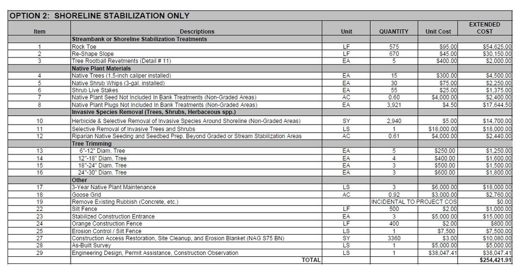
14 Option # 2: Bank Stabilization / Shoreline Enhancement Option # 2 Bank Stabilization / Shoreline Enhancement includes Bioengineering stabilization for existing eroding shoreline areas as well as replacement of invasive shrubs and trees with deep-rooted native species to enhance shoreline stabilization. However, Option # 2 does not address the exposed mud flats and sediment deposition within the impoundment. 14 BEFORE AFTER Photos 4 through 5: Example conversion of eroding shoreline with invasive shrubs (left) into a stabilized shoreline (right) with native plantings and shoreline wetland vegetation. Advantages: - Shoreline stabilization and enhancement - Reduction of sediment deposition within the impoundment from shoreline erosion Disadvantages: - No removal of sediment deposits - No stabilization of sediment deposits - No resolution for odors, aesthetic impacts within the impoundment, water quality impairment, or other factors.
15 15 Permit Considerations: - No hydraulic modeling may be necessary, since the existing outlet structure would not be modified. Option 2 proposes to restore the corridor through stabilization and restoration of the banks and vegetation along the shoreline of the facility. Such modification will not have an appreciable impact on the Manning's 'n', or resistance to flow, for this reach. Also, the sections associated with the facility are significantly wider than the rest of the stream, which will result in low velocities through this reach. This means any proposed changes to the vegetation will have little, if any, hydraulic impact and should not require modeling. - Agencies likely to require permit review for Option # 1: U.S. Army Corps of Engineers notification (permit submittal likely not necessary if no fill or discharge occurs in waters of the U.S.) Kane/DuPage Soil and Water Conservation District Village of Downers Grove Wetland and Riparian submittal (Tab 4 and 5, respectively) would also need approval from the Village. Other Factors: - Due to the Disadvantages described above, Option # 2 Shoreline Stabilization is not considered to be a comprehensive solution for existing problems. However, it does provide a desirable shoreline enhancement that would also reduce sediment deposition within the impoundment. Therefore, at least portions of Option # 2 may be desirable to implement to supplement one of the other selection Options. Costs - Cost Option # 2 = $254,421 for Bank Stabilization / Shoreline Enhancement. - This includes conversion of the shoreline from invasive species into native species, as well as over 556 linear feet of biotechnical bank stabilization, such as the eroding Loomes Avenue inlet area.
16 16


17 Option 3: Dam Removal with Stream and Wetland Restoration Option 3 Dam Removal with Stream and Wetland Restoration is considered an environmentally sound solution for existing problems. Option # 3 provides cost effective long-term elimination of exposed sediment and mud deposits within the impoundment. With Option # 3, in place of mud flats and nuisance algae blooms, a restored wetland would be constructed. Sediment deposits would be stabilized. A meandering stream channel would flow through the open space area. Native plant seed and plant plugs would be installed throughout the basin area (see Photos 6 through 10 below). 17 BEFORE AFTER BEFORE AFTER Photos 6 through 10 above: Example dam removal and stream restoration project with conversion of mud flats into meandering stream channel with native wetland and prairie.
18 Methods for dam removal could include the following. Dam removal could be accomplished by a phased removal of the center of the existing concrete outlet structure. In order to achieve a desirable stream gradient, comparable to upstream and downstream areas, the concrete invert of the central box culvert (of three existing box culverts) below Woodward Avenue would also be phased. The culvert invert would be sawcut and the stream invert elevation lowered to provide an acceptable stream gradient that will enable a balance between water and sediment transport. This will also protect downstream and upstream areas from disturbance. The channel bottom below Woodward Avenue would be armored at the new, lower elevation, using large rock materials. The outlet area would also be stabilized. 18 Advantages: - Environmentally sound elimination of mud flats and sediment deposits - High long-term cost effectiveness for sediment control - Stream restoration - Wetland restoration - Water quality improvement - Reduced nuisance algae blooms - Reduced odors - Sediment stabilization during the dam removal process using Option # 3a. - Fish passage would be restored through the Project Site - Increased diversity of birds, stream fishes, and other wildlife - Permit agencies may not require sediment testing since the sediment would be stabilized in-place with native wetland and prairie vegetation. - As a possibility, if the project creates new wetland, wetland buffer, or riparian habitat, these may be used to off-set either adverse impacts or mitigation responsibilities for this and/or other projects in the watershed. Enhancement of existing wetlands, buffers, and riparian habitat may also be used for mitigation purposes. - No removal of sediment necessary
19 19 Disadvantages: - Reduced area of open water (although this open water is being converted at present into exposed mud flats). - Permit requirements would require hydraulic modeling to be performed for permit approval. - At least some downstream discharge of sediment would occur. However, streams naturally convey both water and sediment. Permit Considerations: - See Hydraulic Modeling Feasibility Analysis below Option # 3 would require hydraulic modeling to be performed for permit approval, since the outlet structure would be modified. Option 3 will have a hydraulic impact on the flood profile for this reach due to the proposal to lower the thalweg of the existing box culvert, which conveys flow under Woodward Avenue. The lowering of the thalweg through the center box culvert by approximately one foot with no other modifications to the other box culverts would result in a lowered hydraulic profile for the 100-year event by almost 0.2 feet at the confluence just upstream of the on-line facility. Modification of the outer two box culverts under Woodward Avenue through construction of a concrete slab over the inverts would mitigate for the lowering of the hydraulic profile by preserving the limited open area of the existing box culverts. - The Village of Downers Grove is seeking to preserve existing stormwater storage capacity (volume above the existing normal water level control elevation) in a proposed condition. - Agencies likely to require permit review for Option # 1: DuPage County (floodway modifications review) Illinois Department of Natural Resources - Office of Water Resources U.S. Army Corps of Engineers plus joint review agencies (IDNR, FWS, IEPA, SHPO) Illinois EPA U.S. Fish & Wildlife Service Kane/DuPage Soil and Water Conservation District Village of Downers Grove
20 - Permit approvals for the proposed work will require a permit from DuPage County since the construction activities will occur within the Floodway of Prentiss Creek. The permit submittal will likely require two separate hydraulic models, one series of models using the regulatory information (1978-era HEC-2 converted to HEC-RAS and then modified to reflect the existing condition) and one series of models using the DuPage County FEQ information with modifications to reflect the existing and proposed conditions, which would then be compared to the original FEQ model. Further, it is likely that a separate Floodway model for at least the HEC- RAS regulatory information will need to be created, if not for both the HEC-RAS and FEQ models. - It remains unclear whether the Project Site was designed as a stormwater management facility. If so, then wetlands formed within stormwater management facilities are generally not subject to wetland regulations. - Regarding possible excavation of a Sediment Forebay alone, a preliminary discussion with the U.S. Army Corps of Engineers (ACOE) suggest that minor excavation of accumulated silt (Sediment Forebay) would be permitted, without mitigation, if water quality and wetland habitat is not significantly impacted. - Any work within Prentiss Creek would at a minimum, require authorization from the U.S. Army Corps of Engineers. Activities that involve filling or discharging or dredging within the waterway are subject to regulation under the federal Clean Water Act. The area of regulation typically includes the watercourse up to the Ordinary High Water Mark (OHWM), including any natural wetland areas extending beyond the OHWM. - A Wetland and Riparian submittal (Tab 4 and 5, respectively) would also need approval from the Village. 20 Other Factors: - Option # 3 Dam Removal with Stream and Wetland Restoration is considered the most environmentally sound, long-term, cost-effective solution available for this Project Site. - Desirable components of other Options discussed, such as a) Option # 1 Sediment Forebay installed upstream of the impoundment to trap sediment from upstream areas, and/or b) Shoreline Stabilization per Option # 2 may be desirable regardless of which Option is selected

21 21 Costs Two cost options were considered for Dam Removal with Stream Restoration - Cost Option # 3a = $468,726 includes not only dam removal, stream restoration, installation of Fiber Roll to retain some sediment, and installation of plantings, but also installation of structures such as Rock Vane Grade Control or Rock Points to provide sediment stabilization during the dam removal process (sediment destabilization could otherwise be more substantial during dam removal phase). Moreover, these same structures will facilitate long-term stream stabilization at the Project Site. - Cost Option # 3b = $326,814 will accomplish similar objectives as Option # 3a (dam removal, stream restoration, installation of Fiber Roll to retain some sediment, and installation of plantings). However,

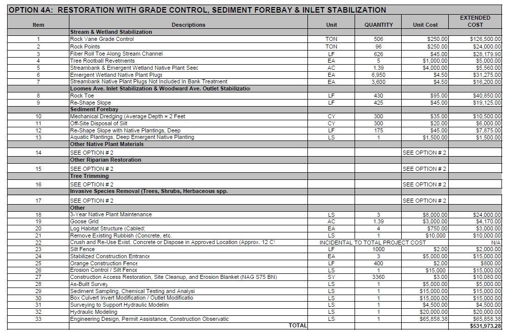
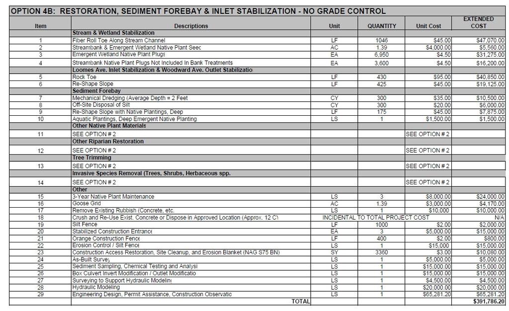
22 Option # 3b does not include structures such as Rock Vane Grade Control or Rock Points to provide short-term and long-term stabilization of sediment deposits. It is more likely that increased discharge of sediment deposits from the impounded area will be discharged downstream under Option # 3b. 22 Other Options & Considerations In addition to the three basic Options discussed above, other combinations of options could also occur. For instance, a combination of Option # 3 Dam Removal with Stream and Wetland Restoration, as well as installation of a Sediment Forebay and stabilization of the Loomes Avenue inlet channel (severe erosion) could occur. This Option # 4a would have a probable cost of $531,973 if grade control were included with stream stabilization. If grade control were not included, then Option # 4b would have a probable cost of $391,786.
23 23
24 24 Hydraulic Modeling Feasibility Analysis Dam Removal: The proposal to modify the on-line facility east of Woodward Avenue, described under Options for Dam Removal and Stream Restoration, necessitated the preparation of hydraulic models to understand the potential hydraulic impacts of the solutions proposed for this section of Prentiss Creek. The hydraulic models were created in HEC-RAS using the existing hydraulic data provided in the original DuPage County FEQ model for Prentiss Creek. Four (4) models were created to better understand the hydraulic situation at the on-line facility and the potential permitting considerations for the project options discussed in this report. The four models prepared are listed as follows: 1. The original model was created as a "direct" conversion from the FEQ model data supplied by the Village to provide baseline conditions for comparison. 2. The second model proposed to lower the invert of the central box culvert at Woodward Avenue with no other improvements to the upstream reach. 3. The third model proposed to lower the invert of the central box culvert at Woodward Avenue with reduction of capacity in the other two culverts through a layer of concrete on the bottom and no other improvements to the upstream reach. 4. The fourth model proposed to lower the invert of the central box culvert at Woodward Avenue with reduction of capacity in the other two culverts through a layer of concrete on the bottom and also improvements in the form of rock vanes and weirs to provide for the establishment of a defined stream channel in the upstream reach. The results from the hydraulic models indicate that the proposed improvements will not significantly impact the hydraulic character of the stream corridor and that any of the proposed options can be permitted. It should be noted that, in the case of Option # 3, care will need to be exercised in order to preserve the hydraulic character of the stream and maintain the stream storage presently being utilized by the on-line facility. We note that the original FEQ model is unclear with regard to the hydraulic character of the Woodward Avenue box culvert and weir complex. The elevations in the FEQUTL input file seem to describe the upstream end of the box culverts as having the same elevation as the upstream weir. Field observation indicates that this is not the case. It is likely that future permitting, for this project or others on this corridor, will require clarification of this hydraulic condition, through
25 additional survey and updated FEQ modeling. This concept study did not require revisions to establish a more exact hydraulic understanding, since the concepts are comparative in nature and seek only an understanding of potential permitting considerations. Hydraulic Modeling Results/Conclusions The proposed restoration and stabilization work on the Prentiss Creek facility east of Woodward Avenue should not affect the hydraulic characteristics of Prentiss Creek, with the exception of Option Option 1 simply proposes to change the section below the hydraulic control at Woodward and will have little impact with the possible exception of lowering the hydraulic profile a small amount. From a permitting perspective, this potential lowering should not be modeled nor should it be counted on since the dredging activities would fall under a maintenance activity and future sedimentation would then impact the hydraulic profile negatively. Option 2 proposes to restore the corridor through stabilization and restoration of the banks and vegetation along the shoreline of the facility. Such modification will not have an appreciable impact on the Manning's 'n', or resistance to flow, for this reach. Also, the sections associated with the facility are significantly wider than the rest of the stream, which will result in low velocities through this reach. This means any proposed changes to the vegetation will have little, if any, hydraulic impact and should not require modeling. Option 3 will have a hydraulic impact on the flood profile for this reach due to the proposal to lower the thalweg of the existing box culvert, which conveys flow under Woodward Avenue. The lowering of the thalweg through the center box culvert by approximately one foot with no other modifications to the other box culverts would result in a lowered hydraulic profile for the 100-year event by almost 0.2 feet at the confluence just upstream of the on-line facility. Modification of the outer two box culverts under Woodward Avenue through construction of a concrete slab over the inverts would mitigate for the lowering of the hydraulic profile by preserving the limited open area of the existing box culverts. Hydraulic Modeling Permit Considerations Permit approvals for the proposed work will require a permit from DuPage County since the construction activities will occur within the Floodway of Prentiss Creek. The permit submittal will likely require two separate hydraulic models, one series
26 of models using the regulatory information (1978-era HEC-2 converted to HEC- RAS and then modified to reflect the existing condition) and one series of models using the DuPage County FEQ information with modifications to reflect the existing and proposed conditions, which would then be compared to the original FEQ model. Further, it is likely that a separate Floodway model for at least the HEC-RAS regulatory information will need to be created, if not for both the HEC- RAS and FEQ models. 26 Hydraulic Modeling Results and Comparisons: Model Description 100-year 10-year Approx. 2-year Discharge Elev. Discharge Elev. Discharge Elev. Location: Downstream of Woodward Ave Culvert 1 - Correctedcs Base Conversion Corrected- Opt3O Drop Center Culvert Corrected- Opt3 Drop Center Culvert, Fill Inverts Corrected- Opt3A Drop Center Culvert, Fill Inverts, Rock Vanes Location: Upstream of Woodward Ave Culvert 1 - Correctedcs Base Conversion Corrected- Opt3O Drop Center Culvert Corrected- Opt3 Drop Center Culvert, Fill Inverts Corrected- Opt3A Drop Center Culvert, Fill Inverts, Rock Vanes Location: Confluence 1 - Correctedcs Base Conversion Corrected- Opt3O Drop Center Culvert Corrected- Opt3 Drop Center Culvert, Fill Inverts Corrected- Opt3A Drop Center Culvert, Fill Inverts, Rock Vanes Notes: 1. The 10 and 100-year information was based in flows and starting WSEL taken from the FIS.
27 2. The approximate 2-year information was based in flows from the FEQ and an estimated starting WSEL. 27 Summary Recommendation: Based on all information as provided above, we recommend that either Option # 3a, # 3b, # 4a, or # 4b be considered for implementation at the Project Site. This is because these options provide a long-term cost effective approach, environmentally sound techniques, and because multiple objectives and benefits will be provided to the community.

 - KENSINGTON PLACE.")

28 PRENTISS CREEK (SUB E) - KENSINGTON PLACE CONCEPT PLAN VILLAGE OF DOWNERS GROVE, ILLINOIS INDEX TO SHEETS SHEET 1 - COVER SHEET SHEET 2 - EXISTING CONDIITONS SHEET 3 - OPTION # 1 DREDGING SHEET 4 - OPTION # 2 SHORELINE STABILIZATION SHEET 5 - OPTION # 3 DAM REMOVAL & STREAM RESTORATION SHEET 6 - DETAILS OWNER VILLAGE OF DOWNERS GROVE 5101 WALNUT AVENUE DOWNERS GROVE, IL CONTACT: NATHANIEL HAWK ENGINEER LIVING WATERS CONSULTANTS, INC. 1 S. 132 SUMMIT AVE, SUITE 304 OAKBROOK TERRACE, IL OFFICE FAX CONTACT: TED GRAY, PE, CFM, CPESC PROJECT LOCATION PRENTISS CREEK (SUB E) - KENSINGTON PLACE. SOUTH OF 63RD STREET, EAST OF WOODWARD AVENUE, NORTH OF PRENTISS DRIVE, VILLAGE OF DOWNERS GROVE, DUPAGE COUNTY, ILLINOIS. WETLAND CONSULTANT JAMES J. BENES & ASSOCIATES 950 WARRENVILLE ROAD SUITE 101 LISLE, IL OFFICE FAX CONTACT: DAVID KOLDOFF Call LIVING WATERS CONSULTANTS, INC. 1 S. 132 SUMMIT AVE, SUITE 304 OAKBROOK TERRACE, IL TEL: FAX: SHEET 1: COVER SHEET PRENTISS CREEK - KENSINGTON PLACE VILLAGE OF DOWNERS GROVE SHEET 1 OF 6

29
30
31

32
33
Department of the Army Permit Application
 Department of the Army Permit Application DA File Number U.S. Army Corps of Engineers Honolulu District Date Received by CEPOH-RO Send Completed Application to: Honolulu District, U.S. Army Corps of Engineers
Stormwater Management Studies PDS Engineering Services Division ES Policy # 3-01
 Stormwater Management Studies PDS Engineering Services Division Revised Date: 2/28/08 INTRODUCTION The City of Overland Park requires submission of a stormwater management study as part of the development
SECTION 11: REGULATORY FLOODWAYS
 SECTION 11: REGULATORY FLOODWAYS Contents 11.1. The Floodway... 11-2 11.1.1. The floodway concept... 11-2 11.1.2. Floodway map... 11-2 11.1.3. Floodway permitting... 11-3 11.1.4. Changing the floodway...
Understanding Stormwater Pollution Prevention Plans (SWPPPs) (SWPPPS)
 (SWPPPS)") Understanding Stormwater Pollution Prevention Plans (SWPPPs) (SWPPPS) Definitions SWPPP: Storm Water Pollution Prevention Plan BMP: Best Management Practice(s) to control pollution IDNR: Iowa Department
Understanding Stormwater Pollution Prevention Plans (SWPPPs) (SWPPPS) Definitions SWPPP: Storm Water Pollution Prevention Plan BMP: Best Management Practice(s) to control pollution IDNR: Iowa Department
COON CREEK WATERSHED DISTRICT PERMIT REVIEW. Spring Lake Park Schools Westwood Middle School st Avenue NE, Spring Lake Park, MN 55432
 PAN 16-112, Westwood Middle School, Page 1 of 6 COON CREEK WATERSHED DISTRICT PERMIT REVIEW MEETING DATE: August 22, 2016 AGENDA NUMBER: 10 FILE NUMBER: 16-112 ITEM: Westwood Middle School RECOMMENDATION:
Environmental Information Worksheet
 Environmental Information Worksheet Water System Owner (Attach additional sheets if necessary) Needs and Alternatives Provide a brief narrative that describes: Current drinking water system needs. Project
SECTION 3 NATURAL RESOURCES
 SECTION 3 NATURAL RESOURCES The natural environment plays a large role in planning for future development. Environmental conditions, such as topography, wetlands, floodplains, and water bodies, can often
Constructed Wetland Pond T-8
 Constructed Wetland Pond T-8 Description A constructed wetlands pond is a shallow retention pond designed to permit the growth of wetland plants such as rushes, willows, and cattails. Constructed wetlands
Stormwater Local Design Manual For Houston County, Georgia
 Stormwater Local Design Manual For Houston County, Georgia Adopted November 15, 2005 TABLE OF CONTENTS 1. FORWARD... 1 2. GENERAL LEVEL OF SERVICE STANDARDS... 2 2.1. DETENTION REQUIREMENTS... 2 2.1.1.
Freight Street Development Strategy
 Freight Street Development Strategy Appendix B: Naugatuck River Floodplain Analysis Freight Street Development Strategy DECEMBER 2017 Page B-1 1.0 NAUGATUCK RIVER FLOODPLAIN AT FREIGHT STREET 1.1 Watershed
NEW CASTLE CONSERVATION DISTRICT. through. (Name of Municipality) PLAN REVIEW APPLICATION DRAINAGE, STORMWATER MANAGEMENT, EROSION & SEDIMENT CONTROL
 PLAN REVIEW APPLICATION DRAINAGE, STORMWATER MANAGEMENT, EROSION & SEDIMENT CONTROL") NEW CASTLE CONSERVATION DISTRICT through (Name of Municipality) PLAN REVIEW APPLICATION DRAINAGE, STORMWATER MANAGEMENT, EROSION & SEDIMENT CONTROL Office use only: Received by Municipality: Received by
NEW CASTLE CONSERVATION DISTRICT through (Name of Municipality) PLAN REVIEW APPLICATION DRAINAGE, STORMWATER MANAGEMENT, EROSION & SEDIMENT CONTROL Office use only: Received by Municipality: Received by
Information for File # PRH
 Information for File # 2016-02602-PRH Applicant Corps Contact Tom Morley Paul Hauser Address 152 Baker Drive, Redwood Falls, MN 56283 E-Mail Paul.R.Hauser@usace.army.mil Phone 651-290-5357 Primary County
STREAM RESTORATION PURPOSE, PRACTICE, AND METHODS. By Marcus Rubenstein, CPESC
 STREAM RESTORATION PURPOSE, PRACTICE, AND METHODS By Marcus Rubenstein, CPESC WHAT IS STREAM RESTORATION? The return of a stream s lost natural functions, usually resulting from watershed alterations,
MODEL Stormwater Local Design Manual. City of Centerville
 MODEL Stormwater Local Design Manual City of Centerville Adopted December 6, 2005 TABLE OF CONTENTS 1. FORWARD... 1 2. GENERAL LEVEL OF SERVICE STANDARDS... 1 2.1. DETENTION REQUIREMENTS... 1 2.1.1. Discharge
Appendix D - Evaluation of Interim Solutions
 Appendix D - Evaluation of Interim Solutions D.1 Introduction The implementation of long-term improvements is projected to take 5 to 8 years. To reduce the number of years of flooding impacts, the partner
Constructed Wetland Channel T-9
 Description A constructed wetland channel is a conveyance BMP that is built, in part, to enhance stormwater quality. Constructed wetland channels use dense vegetation to slow down runoff and allow time
TEMPORARY SEDIMENT TRAP CODE
 ILLINOIS URBAN MANUAL PRACTICE STANDARD TEMPORARY SEDIMENT TRAP CODE 960 Source: DEFINITION A small temporary stormwater storage structure designed to trap sediment. PURPOSE The purpose of this practice
Habitat Grant Projects Clinton River Watershed
 Habitat Grant Projects Clinton River Watershed L Y N N E S E Y M O U R E N V I R O N M E N T A L E N G I N E E R O F F I C E O F T H E M A C O M B C O U N T Y P U B L I C W O R K S C O M M I S S I O N
Constructed Wetland Use in Nonpoint Source Control
 Constructed Wetland Use in Nonpoint Source Control Description Constructed wetlands are excavated basins with irregular perimeters and undulating bottom contours into which wetland vegetation is purposely
Notice No Closing Date: May 12, 2017
 Public Notice U.S. Army Corps of Engineers Pittsburgh District In Reply Refer to Notice No. below US Army Corps of Engineers, Pittsburgh District 1000 Liberty Avenue Pittsburgh, PA 15222-4186 Application
STREAMBANK RESTORATION DESIGN
 STREAMBANK RESTORATION DESIGN WITH VINYL SHEET PILE GRADE CONTROL STRUCTURES BRUCE M. PHILLIPS, M.S., P.E. ABSTRACT Grade control structures are an effective channel stabilization measure which can eliminate
STREAM AND BUFFER AREA PROTECTION/RESTORATION
 STREAM AND BUFFER AREA PROTECTION/RESTORATION AMENDMENT OPTIONS TO STRENGTHEN POLICY IN HEADWATERS AREAS DRAFT SUBSEQUENT TO THE JANUARY 25, 2007 MEETING OF THE PLANNING COMMISSION ENVIRONMENT COMMITTEE
E. STORMWATER MANAGEMENT
 E. STORMWATER MANAGEMENT 1. Existing Conditions The Project Site is located within the Lower Hudson Watershed. According to the New York State Department of Environmental Conservation (NYSDEC), Lower Hudson
Public Notice ISSUED: June 29, 2017 EXPIRES: July 31, 2017
 SPONSOR: Gary Pestorious Public Notice ISSUED: June 29, 2017 EXPIRES: July 31, 2017 REFER TO: 2012-01634-DAS SECTION:404 - Clean Water Act 1. WETLAND COMPENSATORY MITIGATION BANK PROPOSAL: Pickerel Lake
iswm TM Criteria Manual City of Azle Section 14 City of Azle Subdivision Ordinance DRAFT-June Chapter 1
 City of Azle Section 14 City of Azle Subdivision Ordinance DRAFT-June 2010... Chapter 1 i CITY OF AZLE iswm CRITERIA MANUAL FOR SITE DEVELOPMENT AND CONSTRUCTION Incorporating the Regional NCTCOG Integrated
16.0 Water Quality Management Criteria for Developed Land
 October 2003, Revised February 2005 Criteria for Developed Land Page 1 16.1 Introduction 16.0 Water Quality Management Criteria for Developed Land Stormwater quality control is an integral part of any
I THOUGHT IT WAS JUST WET LAND: A GUIDE TO ENVIRONMENTAL PERMITTING FOR AIRPORTS ROAD SCHOOL 2018 SIMON DAVIES, SENIOR SCIENTIST MARCH 7, 2018
 I THOUGHT IT WAS JUST WET LAND: A GUIDE TO ENVIRONMENTAL PERMITTING FOR AIRPORTS ROAD SCHOOL 2018 SIMON DAVIES, SENIOR SCIENTIST MARCH 7, 2018 Definition Regulatory Definition - Those areas that are inundated
Doyle Park Reconstruction Project Improving Flood Control Facilities to Meet a TMDL
 Doyle Park Reconstruction Project Improving Flood Control Facilities to Meet a TMDL Ann Arbor, Michigan Washtenaw County Drain Commissioner & Malletts Creek Coordinating Committee November, 2007 Janis
Ponds. Pond A water impoundment made by excavating a pit, or constructing a dam or an embankment.
 POND SITE SELECTION AND CONSTRUCTION Uses, Planning, & Design David Krietemeyer Area Engineer USDA-NRCS June 20, 2008 Uses Considerations for Location of Commonly Used Terms Pond A water impoundment made
Lyon Creek Cedar Way Stormwater Detention Dam Operation and Maintenance Manual
 Lyon Creek Cedar Way Stormwater Detention Dam Operation and Maintenance Manual Prepared by: Mike Shaw Stormwater Program Manager City of Mountlake Terrace January 2010 Section I General Information This
Standards for Soil Erosion and Sediment Control in New Jersey May 2012 STANDARD FOR GRASSED WATERWAYS. Definition. Purpose
 STANDARD FOR GRASSED WATERWAYS Definition A natural or constructed watercourse shaped or graded in earth materials and stabilized with suitable vegetation for the safe conveyance of runoff water. Purpose
APPENDIX H Guidance for Preparing/Reviewing CEQA Initial Studies and Environmental Impact Reports
 APPENDIX H H.1 Guidance for Preparing and Reviewing CEQA Initial Studies Step 1: Consider the Project Characteristics as Provided by the Project Applicant Review the project application and draft plan
New Castle County, DE. Floodplain Regulations
 New Castle County, DE Floodplain Regulations John J. Gysling, PE CFM Department of Land Use New Castle County, DE February 26, 2009 Today s Presentation Floodplain Protection and Uses Terms and Definitions
7/16/2012. Post Construction Best Management Practices (PCBMPs) Article VIII: Post Construction Best Management Practices
 Article VIII: Post Construction Best Management Practices") Post Construction Best Management Practices (PCBMPs) Article VIII: Post Construction Best Management Practices Presented by Jennifer Boyer DuPage County DEC Includes BMPs intended to provide volume control
Post Construction Best Management Practices (PCBMPs) Article VIII: Post Construction Best Management Practices Presented by Jennifer Boyer DuPage County DEC Includes BMPs intended to provide volume control
Temporary Watercourse Crossing: Culverts
 Temporary Watercourse Crossing: Culverts DRAINAGE CONTROL TECHNIQUE Low Gradient Velocity Control Short Term Steep Gradient Channel Lining Medium-Long Term Outlet Control Soil Treatment Permanent Symbol
Chapter 10 Natural Environment
 Chapter 10 Natural Environment Existing Conditions The Natural Environment Element addresses the protection, conservation, preservation, and restoration of the natural resources the Bayview Ridge Subarea,
Erosion & Sedimentation Control Policy
 Issue Date 10/22/2010 Page 1 of 8 Erosion & Sedimentation Control Policy Introduction: Soil erosion is the removal of soil by water, wind, ice or gravity and sediment deposition occurs when the rate of
BIG ROCHE A CRI LAKE CHARACTERISTICS
 BIG ROCHE A CRI LAKE CHARACTERISTICS Lake Description Big Roche Cri Lake is located in north central Adams County and has a surface area of 205 acres, a shoreline length of 6.1 mile, a volume of 6,993
TORCH LAKE TOWNSHIP WATER QUALITY ACTION PLAN
 TORCH LAKE TOWNSHIP WATER QUALITY ACTION PLAN Elk-River-Chain-of-Lakes Gaps Analysis Project The Watershed Center Grand Traverse Bay Tip of the Mitt Watershed Council Michigan Department of Natural Resources
Phase II Report on Hydrology, Hydraulics, and Low Water Dams
 Phase II Report on Hydrology, Hydraulics, and Low Water Dams Arkansas River Corridor Tulsa, OK May 2005 Submitted To: U. S. Army Corps of Engineers Tulsa District Prepared by: The GUERNSEY Team 5555 N.
VILLAGE OF BELLAIRE WATER QUALITY ACTION PLAN
 VILLAGE OF BELLAIRE WATER QUALITY ACTION PLAN Elk-River-Chain-of-Lakes Gaps Analysis Project The Watershed Center Grand Traverse Bay Tip of the Mitt Watershed Council Michigan Department of Natural Resources
APPENDIX D: COST ESTIMATES FOR STUDY REACHES
 D-1 APPENDIX D: COST ESTIMATES FOR STUDY REACHES This appendix provides approximate quantity and cost information for the higher-priority improvement measures identified in the reach tables in Appendix
LEGAL AUTHORITY AND JURISDICTIONS
 CALIFORNIA DEPARTMENT OF FISH AND GAME RIPARIAN RESOURCES AND REGULATORS: The DFG Lake and Streambed Alteration 1600 Process LEGAL AUTHORITY AND JURISDICTIONS Serge Glushkoff CENTRAL COAST REGION YOUNTVILLE
WATERSHED. Maitland Valley. Report Card 201
 Maitland Valley WATERSHED Report Card 201 The Maitland Valley Conservation Authority has prepared this report card as a summary on the state of our forests, wetlands, surface water, and ground water resources.
STORMWATER RUNOFF AND WATER QUALITY IMPACT REVIEW
 SUBCHAPTER 8 STORMWATER RUNOFF AND WATER QUALITY IMPACT REVIEW 7:45-8.1 Purpose and scope of review Except for those projects expressly exempted by this chapter or waived by the Commission, the Commission
Standards for SWMF s. (Stormwater Management Facilities) Lacombe County s Guide to Developing Stormwater Management Facilities
 Lacombe County s Guide to Developing Stormwater Management Facilities") Standards for SWMF s (Stormwater Management Facilities) Lacombe County s Guide to Developing Stormwater Management Facilities August 2017 PREAMBLE Development results in a great amount of impervious area,
Standards for SWMF s (Stormwater Management Facilities) Lacombe County s Guide to Developing Stormwater Management Facilities August 2017 PREAMBLE Development results in a great amount of impervious area,
DEPARTMENT OF ENVIRONMENTAL PROTECTION Bureau of Water Quality Protection. Design Criteria - Wetlands Replacement/Monitoring
 DEPARTMENT OF ENVIRONMENTAL PROTECTION Bureau of Water Quality Protection DOCUMENT NUMBER: 363-0300-001 TITLE: Design Criteria - Wetlands Replacement/Monitoring EFFECTIVE DATE: February 11, 1997 AUTHORITY:
STORMWATER AND EROSION CONTROL PERMIT
 STORMWATER MANAGEMENT AND EROSION CONTROL PERMIT INSTRUCTIONS AND INFORMATION Any project that involves the disturbance of ANY quantity of land requires the applicant to receive approval for the project
BOONE COUNTY COMPREHENSIVE STORMWATER MANAGEMENT PLAN
 BOONE COUNTY COMPREHENSIVE STORMWATER MANAGEMENT PLAN Approved by the Boone County Stormwater Committee September 23, 2010 Approved by the Boone County Board December 21, 2011 Prepared for: Boone County
The total population of the township is 9,942 (2015 Five-Year American Community Survey [ACS]). The median household income is over $109,000.
![The total population of the township is 9,942 (2015 Five-Year American Community Survey [ACS]). The median household income is over $109,000.](/thumbs/72/67990406.jpg "The total population of the township is 9,942 (2015 Five-Year American Community Survey [ACS]). The median household income is over $109,000.") East Bradford Township, Pennsylvania Motivated by watershed impairment caused by suburban development over the past 30 years, a township with a full slate of water quality improvement programs looks outside
East Bradford Township, Pennsylvania Motivated by watershed impairment caused by suburban development over the past 30 years, a township with a full slate of water quality improvement programs looks outside
SOUTH FLORIDA WATER MANAGEMENT DISTRICT. Question 13: Wetlands
 SOUTH FLORIDA WATER MANAGEMENT DISTRICT Question 13: Wetlands 1. The wetland responses and topographical data provided in the ADA for the 520- acre project site are conceptual in nature. The referenced
Review of State and Federal Stormwater Regulations November 2007
 Review of State and Federal Stormwater Regulations November 2007 By: James T. Spaulding, PE, CPESC Joseph M. Ducharme, Jr., PE TTG ENVIRONMENTAL CONSULTANTS, LLC 27 LOCKE ROAD, CONCORD, NH 03301-5301 TELEPHONE:
Application for resource consent Form B Damming and diversion of water
 Application for resource consent Form B Damming and diversion of water Notes Resource use activities must meet all the conditions of any relevant Permitted Activity Rules in the Waikato Regional Plan or
BMP #: Infiltration Basin
 Structural BMP Criteria BMP #: Infiltration Basin An Infiltration Basin is a shallow impoundment that stores and infiltrates runoff over a level, subtle, uncompacted, (preferably undisturbed area) with
EFFECT OF UPSTREAM DEVELOPMENT ON THE CLEAR CREEK AREA
 EFFECT OF UPSTREAM DEVELOPMENT ON THE CLEAR CREEK AREA Technical Memorandum Farming in the Floodplain Project Prepared for May 2017 PCC Farmland Trust Photo credit: Google Earth TABLE OF CONTENTS Page
APPENDIX F. SECTION 404(B)(1) EVALUATION SHORT VERSION. Herbert Hoover Dike Dam Safety Modification Study
(1) EVALUATION SHORT VERSION. Herbert Hoover Dike Dam Safety Modification Study") Appendix F Section 404(b)(1) APPENDI F. SECTION 404(B)(1) EVALUATION SHORT VERSION Herbert Hoover Dike Dam Safety Modification Study HHD Dam Safety Modification Study EIS June 2016 E i Appendix F Section
Appendix F Section 404(b)(1) APPENDI F. SECTION 404(B)(1) EVALUATION SHORT VERSION Herbert Hoover Dike Dam Safety Modification Study HHD Dam Safety Modification Study EIS June 2016 E i Appendix F Section
Florida Department of Environmental Protection. Bureau of Mining and Minerals Regulation. Regulation of Mines. Howard J. Hayes, Program Administrator
 Florida Department of Environmental Protection Bureau of Mining and Minerals Regulation Regulation of Mines Howard J. Hayes, Program Administrator April 2011 What is a mine? Nonphosphate mine: Subsections
719 Griswold, Suite 820 Detroit, MI DANVERS POND DAM REMOVAL AND STREAM RESTORATION PROJECT
 Great Lakes Restoration Initiative Grant Final Report US EPA Grant GL 00E006 43 October, 2013 Valley Woods Wetland Southfield Lola Valley Grow Zone Wayne County Parks Venoy Park Grow Zone Wayne County
Municipal Stormwater Ordinances Summary Table
 APPENDIX F Municipal Ordinances Summary Table Municipality Abington Bryn Athyn Borough Hatboro Borough Ordinance, SALDO Runoff equals pre post Erosion Sediment Control Water Quality Requirements Any which
SW-74 SERENOVA PRESERVE SITES 2, 3, 4, 8 MITIGATION PLAN
 SW-74 SERENOVA PRESERVE SITES 2, 3, 4, 8 MITIGATION PLAN BACKGROUND INFORMATION Project SWIM? Aquatic Control? Exotic Control? Mitigation Bank? Type No No No No Mitigation Restoration and enhancement Type
(For individual lake and stream classifications in Cook County, refer to Appendix II)
") Article 7 Sec. 7.01 Shoreland Management Regulations Policy The uncontrolled use of shorelands of Cook County, Minnesota affects the public health, safety and general welfare not only by contributing to
Article 7 Sec. 7.01 Shoreland Management Regulations Policy The uncontrolled use of shorelands of Cook County, Minnesota affects the public health, safety and general welfare not only by contributing to
SECTION STORM DRAINAGE DESIGN, GRADING, AND WATER QUALITY TECHNICAL CRITERIA TABLE OF CONTENTS PAGE 402 STORM DRAINAGE DESIGN CRITERIA 400-1
 CITY OF THORNTON Standards and Specifications Revised: October 2012 SECTION 400 - STORM DRAINAGE DESIGN, GRADING, AND WATER QUALITY TECHNICAL CRITERIA TABLE OF CONTENTS PAGE 401 GENERAL PROVISIONS 400-1
CHAPTER 6 ADDITIONAL STANDARDS APPLYING TO SHORELAND AREAS AND PUBLIC WATERS
 CHAPTER 6 ADDITIONAL STANDARDS APPLYING TO SHORELAND AREAS AND PUBLIC WATERS Section 1 Intent. 49 Section 2 Floodplain Requirements 49 Section 3 Water-Oriented Accessory Structures 50 Section 4 Stairways,
In re: Town of Norwich Pool Dam Reconstruction, Stream Alteration Permit Application
 Agency of Natural Resources October 20, 2015 Neil R. Fulton Town Manager Town of Norwich P.O. Box 376 Norwich, VT 05055 In re: Town of Norwich Pool Dam Reconstruction, Stream Alteration Permit Application
Duwamish Waterway Self Guided Tour: Turning Basin Number Three and Terminal 105 Aquatic Habitat Restoration Sites
 Duwamish Waterway Self Guided Tour: Turning Basin Number Three and Terminal 105 Aquatic Habitat Restoration Sites Text and illustrations in the following pages include: (1) summary information describing
Stream Reaches and Hydrologic Units
 Chapter United States 6 Department of Agriculture Natural Resources Conservation Service Chapter 6 Stream Reaches and Hydrologic Units Rain clouds Cloud formation Precipitation Surface runoff Evaporation
RIVERSIDE OXBOW FORT WORTH, TEXAS CHAPTER 3 IDENTIFICATION OF PROBLEMS AND OPPORTUNITIES
 RIVERSIDE OXBOW FORT WORTH, TEXAS CHAPTER 3 IDENTIFICATION OF PROBLEMS AND OPPORTUNITIES Regular study team meetings were held with the Tarrant Regional Water District, the USFWS, Streams and Valleys,
Municipal Stormwater Management Planning
 Municipal Stormwater Management Planning Christopher C. Obropta, Ph.D., P.E. Water Resources Extension Specialist with Rutgers Cooperative Extension Assistant Professor with Department of Environmental
CHAPTER 9 DISCUSSIONS, CONCLUSIONS, AND RECOMMENDATIONS
 CHAPTER 9 DISCUSSIONS, CONCLUSIONS, AND RECOMMENDATIONS This chapter summarizes the results of feasibility level investigations undertaken to identify solutions to the water and related land resource problems
CHAPTER 8 EROSION AND SEDIMENT CONTROL PLAN REQUIREMENTS
 CHAPTER 8 EROSION AND SEDIMENT CONTROL PLAN REQUIREMENTS 8.1 INTRODUCTION To minimize the detrimental effects of erosion and sedimentation, Henrico County requires that those individuals responsible for
SECTION 3 DRAINAGE. 3-1 General. 3-2 Drainage Ordinances and Legal Requirements
 SECTION 3 DRAINAGE 3-1 General All Drainage plans for proposed development shall be prepared by a Professional Engineer registered in Virginia, except as noted below. Further, their seal and signature
Carp Creek 2013 Summary Report
 Monitoring Activity in the Carp River Watershed In 2012, Mississippi Valley Conservation Authority (MVCA) worked with Friends of the Carp River (FCR) on a preliminary assessment of the Carp River. This
Small Project Proposal
 Combined Scoping and Notice and Comment Document Small Project Proposal USDA Forest Service Fishlake National Forest Beaver Ranger District Sevier County, Utah The purpose of this document is to inform
Chapter 4 Watershed Goals and Objectives
 Chapter 4 Watershed Goals and Objectives Eight (8) long-term watershed goals have been developed by the NEW Watershed Advisory Group (WAG) after consideration of discussions held during monthly watershed
Implementing Stormwater Management through Split-Flow Drainage Design
 Implementing Stormwater Management through Split-Flow Drainage Design Stuart Patton Echols PhD, ASLA, RLA Assistant Professor - Department of Landscape Architecture 210 Engineering Unit D Center for Watershed
Stream Watch Visual Survey Instructions
 Stream Watch Visual Survey Instructions The Stream Watch Visual Survey is based on assessment parameters from the EPA's Rapid Bioassessment Protocol Habitat Assessment, Georgia Adopt a Stream Visual Survey,
CHAPTER 2 EROSION CONTROL
 CHAPTER 2 EROSION CONTROL 2.1 EROSION AND EROSION CONTROL Understanding Erosion Erosion occurs when soil particles are detached from the land surface and carried downslope by moving water. Figure 2.1-1
Greenfield Pond B Rehabilitation
 Preliminary Investigation Report Centennial, Colorado November 15, 2011 Prepared for: Liverpool Metropolitan District Prepared by: Stantec Consulting Services, Inc. Table of Contents Executive Summary...
Best Management Practice Fact Sheet 14: Wet Ponds
 Publication 426-133 Best Management Practice Fact Sheet 14: Wet Ponds David J. Sample, Assistant Professor and Extension Specialist, Biological Systems Engineering, Virginia Tech Stefani Barlow, Undergraduate
Nutrient Management in. A presentation to the West Metro Water Alliance
 Nutrient Management in Developing and Agricultural Areas A presentation to the West Metro Water Alliance Chris Meehan, P.E. May 25, 2011 Agenda Physical Improvements Planning Improvements How to get it
Location Drainage Study
 Location Drainage Study PROJECT ROUTE: LIMITS: MUNICIPALITY/COUNTY: JOB NUMBER: IL 47 at Burlington Road 750ft NW to 750ft SE of IL 47(Burlington), & 1000ft S to 1000ft N of Burlington (IL47) Kane County
DRAFT GREATER MOOSES TOOTH TWO (GMT2) DEVELOPMENT PROJECT PERMITTEE RESPONSIBLE WETLANDS MITIGATION PLAN NATIONAL PETROLEUM RESERVE-ALASKA
 DEVELOPMENT PROJECT PERMITTEE RESPONSIBLE WETLANDS MITIGATION PLAN NATIONAL PETROLEUM RESERVE-ALASKA") DRAFT GREATER MOOSES TOOTH TWO (GMT2) DEVELOPMENT PROJECT PERMITTEE RESPONSIBLE WETLANDS MITIGATION PLAN NATIONAL PETROLEUM RESERVE-ALASKA Prepared for: ConocoPhillips Alaska, Inc. Anchorage, AK March
DRAFT GREATER MOOSES TOOTH TWO (GMT2) DEVELOPMENT PROJECT PERMITTEE RESPONSIBLE WETLANDS MITIGATION PLAN NATIONAL PETROLEUM RESERVE-ALASKA Prepared for: ConocoPhillips Alaska, Inc. Anchorage, AK March
Living Shorelines & Coastal Resiliency: A Consultants Perspective. Presented by: Bethany Bearmore, P.E. Louis Berger
 Living Shorelines & Coastal Resiliency: A Consultants Perspective Presented by: Bethany Bearmore, P.E. Louis Berger Living Shorelines & Coastal Resiliency A Consultants Perspective 1. Why 2. Process 3.
Chapter 6. Hydrology. 6.0 Introduction. 6.1 Design Rainfall
 6.0 Introduction This chapter summarizes methodology for determining rainfall and runoff information for the design of stormwater management facilities in the City. The methodology is based on the procedures
ARTICLE A. POST-DEVELOPMENT STORMWATER MANAGEMENT FOR NEW DEVELOPMENT AND REDEVELOPMENT
 CHAPTER 11. STORMWATER MANAGEMENT ARTICLE A. POST-DEVELOPMENT STORMWATER MANAGEMENT FOR NEW DEVELOPMENT AND REDEVELOPMENT DIVISION 1. GENERALLY Sec. 10-11001. FINDINGS It is hereby determined that: (1)
CHAPTER 3 Environmental Guidelines for WATERCOURSE CROSSINGS GOVERNMENT OF NEWFOUNDLAND AND LABRADOR DEPARTMENT OF ENVIRONMENT AND LABOUR
 GOVERNMENT OF NEWFOUNDLAND AND LABRADOR DEPARTMENT OF ENVIRONMENT AND LABOUR CHAPTER 3 Environmental Guidelines for WATERCOURSE CROSSINGS WATER RESOURCES MANAGEMENT DIVISION Water Investigations Section
KRISTOPHER J. KRZYSTON, CEI, CEM
 PERMITTING IN NEW JERSEY KRISTOPHER J. KRZYSTON, CEI, CEM Kristopher J. Krzyston Rutgers graduate 1994 B.S. Environmental Planning Certificate in G.I.S. Assistant Division Manager Environmental Science
Sediment Management Alternatives Analysis
 Conservancy District April 19, 2017 Sediment Management Alternatives Analysis Report prepared for the Conservancy District -Unionville, IN Report By: KCI Technologies, Inc. 6983 Corporate Circle Indianapolis,
Low Head Stone Weirs By: Jon Fripp 1, Dr. Craig Fischenich 2, and Dr. David Biedenharn 2
 Low Head Stone Weirs By: Jon Fripp 1, Dr. Craig Fischenich 2, and Dr. David Biedenharn 2 Complexity Low Moderate High Environmental Value Low Moderate High Cost Low Moderate High OVERVIEW Establishing
King County Flood Control District approves grants for flood prevention projects Regional projects to benefit from district funds
 News Release Contact: Al Sanders 206-477-1016 August 31, 2015 Flood Control District approves grants for flood prevention projects Regional projects to benefit from district funds The Flood Control District
Stream Simulation in Very Low Gradient Channels
 University of Massachusetts - Amherst ScholarWorks@UMass Amherst International Conference on Engineering and Ecohydrology for Fish Passage International Conference on Engineering and Ecohydrology for Fish
PUBLIC NOTICE. REPLY TO: Denver Regulatory Office 9307 South Wadsworth Blvd 30 DAY NOTICE Littleton, CO FAX (303)
") PUBLIC NOTICE US Army Corps of Engineers Omaha District Application No: NWO-2017-01366-DEN Project: Douglas Lane Tributary Stabilization Project Applicant: Town of Castle Rock Waterway: Douglas Lane Tributary
PUBLIC NOTICE US Army Corps of Engineers Omaha District Application No: NWO-2017-01366-DEN Project: Douglas Lane Tributary Stabilization Project Applicant: Town of Castle Rock Waterway: Douglas Lane Tributary
Design Features of Constructed Wetlands for Nonpoint Source Treatment. September 1995
 Design Features of Constructed Wetlands for Nonpoint Source Treatment September 1995 Brochure written by William W. Jones, School of Public and Environmental Affairs, Indiana University, Bloomington, Indiana.
UMD Storm Water Program Construction Requirements. Greg Archer, MBA Environmental Compliance Specialist
 UMD Storm Water Program Construction Requirements Greg Archer, MBA Environmental Compliance Specialist Phase 2 Regulatory Overview Dec. 1999 EPA issues Phase 2 Federal Register Municipalities (MS4) from
Town of Essex, Vermont January, 2017 Standard Specifications For Construction CHAPTER 3 EROSION AND SEDIMENT CONTROL
 CHAPTER 3 EROSION AND SEDIMENT CONTROL CHAPTER 3 EROSION AND SEDIMENT CONTROL Section 300 General Summary All projects constructed within the Town of Essex shall be constructed in strict accordance with
Module 4 Regulatory requirements for Land Disturbing Activities
 Module 4 Regulatory requirements for Land Disturbing Activities MODULE 4 REGULATORY REQUIREMENTS FOR A LDA Module 4a Overview MODULE 4A REGULATORY REQUIREMENTS FOR A LDA ESC Regulations Overview 1990 First
NJDEP Regulations that impact or soon will impact agricultural operations. April 1, 2007 Horses 2007
 NJDEP Regulations that impact or soon will impact agricultural operations. April 1, 2007 Horses 2007 Peter L. Kallin, Ph.D., P.W.S. Phone: 732-499-3600 Ext. 237 E-mail: pkallin@aesop.rutgers.edu www.water.rutgers.edu
Richland County Department of Public Works Engineering (Land Development) Division
 Division") Richland County Department of Public Works Engineering (Land Development) Division Commercial Projects What is a Commercial Project? Projects that are not related to residential single family homes and/or
Richland County Department of Public Works Engineering (Land Development) Division Commercial Projects What is a Commercial Project? Projects that are not related to residential single family homes and/or
US Army Corps of Engineers and Stream Restoration Permitting
 US Army Corps of Engineers and Stream Restoration Permitting Jack Dinne US Army Corps of Engineers-Baltimore Maryland Section Northern May 6, 2014 US Army Corps of Engineers Presentation Overview Corps