Environmental and Social Impact Assessment Part 1. GEO: Adjaristsqali Hydropower Project
|
|
|
- Marcus Francis
- 6 years ago
- Views:
Transcription
1 Environmental and Social Impact Assessment Part 1 Project Number: April 2014 GEO: Adjaristsqali Hydropower Project Prepared by Mott MacDonald and Adjaristsqali Georgia LLC for the Asian Development Bank The environmental impact assessment is a document of the borrower. The views expressed herein do not necessarily represent those of ADB's Board of Directors, Management, or staff, and may be preliminary in nature. Your attention is directed to the Terms of Use section of this website. In preparing any country program or strategy, financing any project, or by making any designation of or reference to a particular territory or geographic area in this document, the Asian Development Bank does not intend to make any judgments as to the legal or other status of any territory or area.

2 Adjaristsqali Hydropower Cascade Project September 2013 Adjaristsqali Georgia LLC
3 Adjaristsqali Hydropower Cascade Project PWR EFR 1 F Adjaristsqali Hydropower Cascade Project 04 September 2013 September 2013 Adjaristsqali Georgia LLC 1. Abashidze Street 6, 6010 Batumi, Georgia Mott MacDonald, 1 Atlantic Quay, Broomielaw, Glasgow G2 8JB, United Kingdom T +44 (0) F +44 (0) W
4 Issue and revision record Revision Date Originator Checker Approver Description Standard A J. Glass V. Hovland L. Chapman Draft for Client approval B J. Glass V. Hovland L. Chapman Draft for Disclosure C V. Hovland V. Hovland L. Chapman Final draft disclosure D V. Hovland V. Hovland L. Chapman Final Report E M. Barnard L. Morton J. Prytherch L. Morton Update to address Lender comments. Draft for client review F M. Barnard L. Morton L. Morton Final draft for disclosure This document is issued for the party which commissioned it and for specific purposes connected with the above-captioned project only. It should not be relied upon by any other party or used for any other purpose. We accept no responsibility for the consequences of this document being relied upon by any other party, or being used for any other purpose, or containing any error or omission which is due to an error or omission in data supplied to us by other parties. This document contains confidential information and proprietary intellectual property. It should not be shown to other parties without consent from us and from the party which commissioned it..
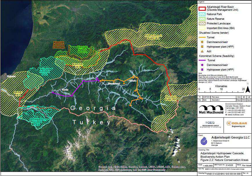
5 Contents Chapter Title Page 1 Introduction 1 2 The Project Background and status Project overview Project components 4 3 The Project and people Introduction Potential beneficial effects and enhancements Potential adverse effects and mitigations Monitoring 9 4 The Project and ecology Introduction Habitats and flora Fauna Fisheries and aquatic habitats Mitigation measures and post-mitigation effects 15 5 The Project and water resources Introduction Potential construction impacts Potential operation impacts Mitigation measures and post-mitigation effects 19 6 The Project and the environment Geology, landslides and seismic risks Materials and waste management Traffic and transportation Noise and vibration Air quality Greenhouse gas emissions Cultural heritage and archaeology Landscape and visual amenity 25 7 Other projects in the Adjaristsqali river basin 26 Appendices 27 Appendix A. Project location and protected areas 28 Appendix B. Project infrastructure 30
6
7 1 Introduction Adjaristsqali Georgia LLC (AGL) is developing a 331 MW hydropower project known as the Adjaristsqali Hydropower Cascade, on the Adjaristsqali River in the Autonomous Republic of Adjara, south-west Georgia (the Project). This non-technical summary (NTS) presents a synopsis of the potential environmental and social issues associated with the Project and measures that have been or will be undertaken to address these issues. The NTS has been based on the Environmental and Social Impact Assessment (ESIA) and associated documents that have been prepared in accordance with international standards to assess the potential environmental and social effects of the Project and any measures that would be needed to reduce or eliminate any significant effects. The ESIA process began in July 2011 and was completed in October 2012 subject to minor updates in May, August and September Throughout this NTS, the area that could be affected by the Project is referred to as the Project Area. This NTS is being made available for public review on the Project s dedicated website ( This website also provides a range of additional information on the Project, including the Stakeholder Engagement Plan (SEP). The website is updated on a regular basis. Anyone may submit comments on the NTS and the Project. Questions and comments can be addressed to AGL via the following contact details: Name: Address: Jeff Terry / Olafur Birgisson Adjaristsqali Georgia LLC (AGL) I. Abashidze Street 6, 6010 Batumi, Georgia Telephone / info@agl.com.ge 1

8 2 The Project 2.1 Background and status Need The Government of Georgia (the Government) has prioritised the development of renewable and alternative sources of energy. Long term goals include the replacement of thermal generation, realisation of Georgia s hydropower resource potential and the attraction of foreign investment in energy projects. Hydropower development on the Adjaristsqali River is considered by the Government to play an important role in achieving these objectives. Development In May 2010 AGL was successful in receiving concessions through a competitive tendering process run by the Government for three potential hydropower schemes on the Adjaristsqali River. The concessions received were for sections of the Adjaristsqali River and a number of its tributaries, in the vicinity of Shuakhevi, Koromkheti and Khertvisi. Following award of the concessions, the preliminary design and layout of the Project was developed through undertaking a series of progressively more detailed studies. As is standard practice, this process began with a feasibility study to confirm that a viable solution was possible. At the start of the feasibility phase, four potential schemes and six potential layouts for each scheme were identified for further consideration. In addition to technical and economic factors, the optioneering exercise included evaluating each scheme and layout Initial scheme options considered against its ability to avoid landslides, villages and areas used for agriculture, historic and cultural features including bridges and existing hydropower projects. Of these factors, the avoidance of landslide risks took precedence. The technical appraisal also considered the ability of each option to manage likely changes in climate. 2
9 The option taken forwards for optimisation from this process included a number of benefits: Fewer intakes and structures on the Adjaristsqali River and its tributaries; Smaller footprint (area of land affected by the Project); and Avoidance of high risk landslide areas and most medium risk landslide areas. An international Environmental and Social Impact Assessment (ESIA) was prepared in parallel with the feasibility study (July 2011-August 2012) with environmental and social issues considered at each stage and reflected in the design and layout of the Project. The final assessment was then carried out on the preferred option. The ESIA was carried out in accordance with International Finance Corporation (IFC) Performance Standards and European Bank for Reconstruction and Development (EBRD) Guidelines in order to assess whether the Project met relevant international environmental and social standards. The ESIA has been subsequently reviewed by the Asian Development Bank (ADB) and found to be in accordance with their requirements. The ESIA was prepared including consideration of all three scheme concessions (Shuakhevi, Koromkheti and Khertvisi). A translated version of the ESIA was also submitted to the Georgian authorities following minor amendment and was found to be in accordance with national ESIA standards. Detailed engineering design was undertaken subsequent to issue of the ESIA. During this process it was identified that significant economic and environmental risks were present with the Khertvisi scheme, including the potential for construction activities to fall within the boundaries of the planned Machakhela National Park. Due to these considerations AGL has confirmed that although it retains the concession at present, the Khertvisi scheme will not be pursued as part of the third and final phase of the Project. The Project to be developed will therefore constitute the Shuakhevi and Koromkheti schemes only. Other notable changes include a reduction in the capacity of the Shuakhevi scheme by 4 MW. A map showing the location of the Project is provided in Appendix A. Status and timescales The Project now comprises two separate hydropower schemes operating in cascade along the Adjaristsqali River. Only the Shuakhevi scheme is the subject of the current round of project financing. Construction of the Shuakhevi scheme is now scheduled to commence in September 2013 with Koromkheti following in Expected completion dates are 2016 and 2019 respectively. Both schemes are designed to be in operation for a minimum of 45 years. 2.2 Project overview The Project includes construction and operation of the Shuakhevi and Koromkheti HPP schemes with total installed capacity of 331 MW. The estimated power output (annual average production) will be 930 GWh of renewable electricity per annum. The Project is intended to be operated as a peaking plant; that is a plant that can achieve output at full capacity quickly during periods of high electricity demand. The Project has been designed specifically for this purpose. 3
 the stored water will be released through tunnels to turbines within a hydro power plant (HPP), where the energy from the rotating")
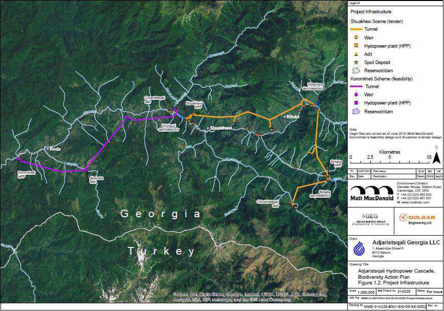
10 Small reservoirs and weirs included in the Project are designed to store water during periods in the day when demand for electricity is lower. During periods of high demand (commanding higher electricity prices) the stored water will be released through tunnels to turbines within a hydro power plant (HPP), where the energy from the rotating turbine is transformed into electricity. This type of HPP relies on gravity to force water through the turbine and as such HPP units are always located downslope of water intakes at the weirs and reservoirs. Once water has passed through the turbines it is returned to the river via a channel known as a tailrace. The Schematic of a typical Hydropower scheme voltage of the generated electricity will be increased via a transformer and switchyard located in proximity to each HPP, to enable export to the electricity supply grid. As the Project is not designed to store water for more than 24 hours or regulate the flow of a river, it is categorised as a run-of-river hydro scheme. Due to the daily release of water, water levels in the reservoirs will go up and down by approximately five to ten meters each day depending on the scheme. The generated electricity will be primarily sold on the Turkish energy market and supplied to the Georgian energy system during the winter (December, January and February). 2.3 Project components The main components of the Project are listed below with accompanying profile drawings. A plan view is provided in Appendix B. Shuakhevi Scheme (181 MW) Dam and reservoir on the Adjaristsqali river at Didachara; Dam and reservoir in the upper reaches of the Skhalta River; One weir to allow abstraction and sediment basin on the Chirukhistsqali River; Transfer / headrace tunnel between Chirukhistsqali weir and small capacity Hydro Power Plant (HPP) at the Skhalta dam HPP (6 MW) Transfer tunnel between Skhalta dam and Didachara reservoir; and Headrace tunnel from Didachara dam to the main HPP unit near Shuakhevi village (175 MW). 4
11 Indicative scheme design profile for Shuakhevi HPP at feasibility stage Koromkheti Scheme (150 MW) Dam and reservoir on the Adjaristsqali River near Khichauri; Weir on the river Chvanistsqali approximately 500 m north of the Khichauri dam; Weir on the Akavreta River approximately 5.5 km south east of Keda; and A series of connected tunnels to divert water from Chvanistsqali weir, Khichauri dam and Akavreta weir to an underground HPP near Koromkheti village (150 MW). Indicative scheme design profile of Koromkheti HPP at feasibility stage 5
12 Associated works To support the main works the following activities will also be required for construction and / or maintenance. Approximate locations are illustrated in Appendix B. Land acquisition associated with temporary and permanent structures; Development of borrow pits to provide aggregate for road building; Excavation of temporary and permanent access portals (known as adits), initially to construct underground infrastructure including tunnels and subsequently during operation for maintenance; Erection of temporary worker accommodation; Creation of temporary storage and work sites at dam and powerhouse locations; Disposal of significant amounts of spoil material from tunnel excavations; Installation and operation of concrete batching plant for the production of concrete to support foundation works; Upgrade of existing access roads to support delivery of equipment to site; Construction of new permanent access and maintenance roads; and Construction of temporary access roads for construction. The Project will also require transmission lines for transmitting the generated electricity to substations for eventual use by consumers. It is proposed that a new 220 kv transmission line will be constructed connecting into existing national grid at Batumi and Akhaltsikhe substations. It is expected that it will be constructed and in operation by late 2015 / early The construction of the transmission line is a separate project and will be undertaken in accordance with the national permitting requirements (this includes requirement to develop a stand-alone ESIA). The development of the transmission line is not included as part of the activities for which AGL are seeking finance. 6

13 3 The Project and people 3.1 Introduction The Project is located within the mostly rural municipalities of Khulo, Shuakhevi and Keda. Residential areas that may be affected by the Project mostly comprise small villages and the total population in the vicinity of the Project is approximately 15,000. The Ethnic Georgians (largely of Christian Orthodox and Muslim denomination) represent the majority of the local population. Depending on the altitude the main income source for the local population consists of growing vegetables (potatoes and tomatoes among others), fruits, tobacco, grapes, and cattle farming. Non-agricultural employment includes work in schools, local administration offices, medical stations and shops. Unemployment rates are higher than the Adjaran average and vary between 20% and 75% across different villages. The unemployment rate is likely to include those dependent on subsistence farming. Those people that may be affected by the Project include: Those villagers living and farmers / land owners working closest to the construction sites; Unemployed people looking for work on the Project, especially the unskilled; Those whose land has and will be acquired (in particular due to lack of availability of replacement land). In such cases proportionate offsetting will be established in line with the ESIA; and People displaced by natural disasters. The views of local people on the Project have been sought and considered through formal Typical conditions for farming in the Adjaristsqali valley stakeholder engagement activities that commenced at the start of the ESIA process. Stakeholder engagement activities undertaken and planned for the future are documented in the Stakeholder Engagement Plan (SEP). 3.2 Potential beneficial effects and enhancements The Project is considered likely to benefit the local community in a number of ways. Construction work for this type of project will require a sizeable labour force and there will be improved employment opportunities for local people. There will be a variable but generally high demand for labour across the estimated six year construction period. It is anticipated that experience gained on the Project will enhance the employability of local people once labour demand during construction has dissipated. Following construction, a reduced labour force will also be required to undertake routine maintenance and operational activities for the lifetime of the Project, considered to be in the region of 45 years. AGL has agreed to enhance employment opportunities for local people through undertaking skills mapping and subsequent establishing of training opportunities for local jobseekers, and is on target to meet its 7

14 commitment to train 600 persons from affected villages. It has in place a Recruitment Policy and this will be openly disclosed with opportunity for public comment. The Recruitment Policy includes a requirement to prioritise local employment equitably between villages taking into account available skills. Other actions that will be taken include publishing the need for staff and labourers locally, prior to recruitment commencing for any phase. This will allow potential employees to make an informed decision about applying for work in consideration of other commitments, such as harvesting. Local infrastructure, including roads and bridges, will be improved and maintained to facilitate construction works. This may result in benefits for existing businesses, including those associated with tourism. It may also allow new businesses to set up in the area. Following construction the improved infrastructure will remain in place for the benefit of the local communities. Local communities will also benefit through additional income to the local municipalities. Local municipalities will receive a yearly property tax from the Project, based on 1% of the value of the Project assets in their area. AGL has also agreed to support communities in identifying social improvement programmes that benefit them through the establishment of a committee and provision of organisational assistance. This may include setting up committee meetings and facilitating contacts between the committee and the municipalities. In relation to the wider area, the associated development of a 220 kv transmission line Health centre in Zamleti village between Batumi and the new substation at Akhaltsikhe will improve the reliability of the grid connection to Batumi, supporting increased electricity demand in the area. It will also improve electricity import and export opportunities to Turkey, Armenia and Azerbaijan as Georgia asserts itself as a power generation and distribution hub for the region. 3.3 Potential adverse effects and mitigations Social studies undertaken for the ESIA identified the potential for several adverse effects on local communities. When major infrastructure projects are developed they can encourage outsiders to migrate into an area in the search for work such as, for example taxi driving or clothes washing. This process is known as induced development and can lead to changes in the local population and cultural tensions can develop. The measures AGL has developed to enhance employment opportunities for local people have been designed to avoid this issue as far as possible. In addition, AGL s procurement practices have been modified to maximise opportunities for local people, and all international workers are to receive training on cultural sensitivities. 8
15 In light of the measures that will be taken by AGL, the assessment has found that detrimental effects of induced development should be avoided and that overall the local population will see benefits from preferential consideration for labour opportunities. The Project will require the permanent use of land that is currently used by local people either formally or informally, for other social or livelihood purposes. There are potential risks to the local population from the purchase of land in the absence of appropriate management. In the worst case, people could be required to leave home against their wishes, or they may be inadequately compensated for lost land and / or income. To avoid adverse effects, AGL will carry out land transactions through negotiated settlement. The formal process is established in AGL s Land Acquisition and Resettlement Framework (LALRF) that has been produced in accordance with IFC guidelines. For comfort that all affected people are identified, AGL will carry out consultation with people engaged in informal livelihood activities (such as the use of the rivers for wood collection and the river bed for building materials collection) in areas that will be affected by the Project. The purpose of this exercise is to find alternative sites to carry out informal activities and / or identify the need for compensation or assistance. 3.4 Monitoring Monitoring of social issues will take place to ensure that legal obligations and obligations set out in the ESIA and associated documents are adhered to. Monitoring and auditing will include of worker management, worker s rights, workers terms and conditions (including the labour accommodation), occupational health and safety and grievances. Monitoring will also confirm that stakeholder engagement and the management of grievances are being carried out as required. 9
16 4 The Project and ecology 1.1 Introduction Georgia is located within the southern Caucasus region, a region of rich and diverse flora and fauna. The Caucasus region has been identified as a Global 200 eco-region (by the WWF) and biodiversity hotspot as one of the top 25 biological rich regions (by Conservation International). While the Adjaristsqali river system is within this eco-region, the area within which the Project is located is degraded with agricultural expansion and village settlements along the entire length of the river basin. There are several nature conservation areas within or adjacent to the Project Area as illustrated in Appendix A. These include Kintrishi Nature Reserve and Important Bird Area (IBA), Machakhela National Park, Mtirala National Park, Shavsheti Ridge IBA, Adjara-Imereti Ridge IBA and Batumi IBA. The significance of any likely impacts related to the construction and operation of the Project is dependent on the presence or absence of species of high conservation concern and their specific sensitivity to likely impacts. As the exact distribution of species in the Project Area is not known, for the purposes of the assessment all species of high conservation value were assumed to be present. Sections provide a summary of the potential impacts of the Project in relation to the different ecological receptors. Mitigation that will be applied to minimise / offset impacts in relation to each of these receptors is discussed in Section Habitats and flora The Adjara region is well known as being of significant botanical interest with high floristic diversity. The Project Area supports three species that are listed as endangered on the red list of Georgia and Adjara and in total 19 protected and notable plant species are present. Forests and rivers within the Project Area are the most important habitat for biodiversity. The conservation value of the habitats varies depending on the species composition, presence of threatened species and degree of disturbance. The Project will result in a loss of habitat, primarily through the construction of access roads, laydown areas and site worker accesses. Further habitat will be lost through the creation of reservoirs. Of those habitats that will be affected, the most significant effects will be on the deciduous forests affected by the Koromkheti scheme. This is due to the sensitive nature of the habitats, the high conservation value and the size of area affected. A large number of protected and notable plant species are present in the deciduous forest habitats in the Project Area. The impact on these species due to habitat loss and degradation from the construction activities, particularly access routes and working areas, would be considered significant in the absence of mitigation. 10
17 1.3 Fauna Birds Bird diversity in the Project Area is relatively high due to the diversity of habitats along the Adjaristsqali and its location in an important area for raptor migration. A total of 161 bird species have been recorded within the Project Area to date, of which 75 are either protected or threatened. Of these, eight bird species of high conservation value were recorded in the Project Area for the ESIA. During construction, birds could be affected through noise disturbance from construction activities and loss and fragmentation of habitats associated with access roads and construction working areas. Of the species of high conservation value present, common Rosefinch is the only ground nesting bird and is most likely to be affected by construction activities. Birds of prey could also be affected should construction works take place close to an active nest site or through an increase in hunting. Prior to mitigation, potential effects on all species of high conservation value were considered significant. During the operational period the loss of habitat associated with reservoir creation could have an adverse effect on birds. However, it is possible that the open water habitats created may benefit certain bird species, such as waders and waterfowl, which could potentially benefit the overall bird diversity along the river catchment. The beneficial effects of this change are not considered significant as habitat changes and the extent of water bodies will be limited by the local topography. Birds breeding in forest areas surrounding the Project could also be affected by disturbance from Project operations, and effects on the common Rosefinch could be significant. Mammals Sixty-two mammal species were recorded along the Adjaristsqali during the biodiversity surveys for the ESIA, but others are known to be present. Two globally threatened mammal species are located in the Project Area. These are the Eurasian otter, considered rare in the Project Area due to a lack of fish and other food sources; and Mehely s horseshoe bat. Other critically endangered or endangered mammals in Georgia that may be in the Project Area are Eurasian lynx, Brown bear, Red-backed vole, Northern chamois and Wild goat. Jackal and Wild boar have also been confirmed as being present. While otters are not particularly abundant in the river systems of Adjara, they do occur. During construction it is considered that otters could be affected by physical and noise disturbance, sediment release into the rivers, habitat loss, noise disturbance and from construction activities in the river acting as an ecological barrier. The main impacts on otters during operation are likely to be from the reduced flows in the river system (which may also affect food availability); from dams and weirs acting as physical barriers to otter movement up and down stream; and from loss of terrestrial habitats along the river margins. Before mitigation is taken into account, the possible effects on otters are considered to be very significant. At least four bat species (including Mehely s horseshoe bat), and a further six possible, were recorded during studies for the ESIA. Bats are likely to be impacted during construction from tree removal for access 11
18 roads, noise and light disturbance, and temporary severance of commuting routes. No known bat roosts occur within the Project Area, although it is likely that some minor tree roosts will be disturbed and lost. Because all bat species are of high conservation value the possible effects on bats during construction are considered potentially very significant in the absence of mitigation. During operation, bats could be affected by the loss of forest habitats (notably tree as roosting sites) due to flooding. However, this will in part be compensated from the creation of open water habitats which will provide favourable foraging habitats. Due to the different value of habitats in different areas, significant adverse effects on bats during operation are only considered possible for the Shuakhevi scheme and overall the operational phase will have a lower impact than construction. Other mammals may be affected during construction in particular through increased risk of hunting, combined with temporary habitat loss and physical and noise disturbance. During operation, potential impacts are considered limited to habitat loss from reservoir creation, and potential occasional hunting due to the permanent increased access to the area. Potential adverse effects on mammal species other than otters and bats are not considered significant for the construction or operation phases. Reptiles and amphibians Fourteen species of reptiles have been recorded or are likely to occur within the Project Area. Of these, two species are globally and nationally threatened and are protected in Georgia. These are Clark s lizard and Caucasus viper. Both species are likely to occur at low abundance in forest edge habitats across the Project Area. Five species of amphibians have also been recorded in the Project Area. Of these, the Caucasian salamander is listed as vulnerable on the IUCN Red List and the Caucasian toad as nearthreatened. The Caucasian toad is common in the Project Area whilst the Caucasian salamander is likely to occur only in the forest habitats at higher elevations associated along the Chirukhistsqali River. Caucasus viper and Clark s lizard may be affected during construction by habitat loss, especially for access roads and construction activities. During operation, possible effects will be similar and linked to the permanent loss of habitat associated with the reservoir, dam sites and roads. Although effects will be limited they are considered significant due to the conservation value of the species. The Caucasian toad could be affected by localised habitat loss and degradation and disruption to local hydrological conditions and changes in water quality. The toad is of medium conservation value and possible adverse effects during construction and operation are not considered significant. The Caucasian salamander would be impacted by habitat loss associated with flooding of the upper Chirukhistsqali River. However, given the likely scarcity of the salamander and the localised impact the effects are not considered significant. 12
19 1.4 Fisheries and aquatic habitats Introduction At least 14 species of fish are present in the Adjaristsqali River and its tributaries within the Project Area, attracted by a diverse range of food sources and habitats suitable for spawning and fry as well as adult fish. Two of the species present are protected and could be affected by the Project; the Black Sea trout and Colchic khramulya. Black Sea trout was found in a number of tributaries of the Adjaristsqali during fish surveys for the ESIA. Whilst some populations are non-migratory, the Black Sea trout is generally known to migrate seasonally in freshwater but does not migrate to the sea. Upstream migration on the Adjaristsqali is thought to be prevented by the Asti dam (below the Project Area). Downstream migration is considered possible however, and the Project has been designed to allow for this requirement (refer to section 4.5). Colchic khramulya was also found to be present in the Adjaristsqali and similarly, is known to migrate within the Adjaristsqali river system. It is subject to the same constraints as Black Sea trout. Black Sea Salmon is a priority species for conservation in the region and surveys were carried out as part of the ESIA to determine its presence in the affected river system. These surveys found no evidence of Black Sea salmon and it is thought at present, that the existing Asti dam is an impassable barrier to upstream migration. To test this assumption, future surveys will be undertaken at different times of the year to check for Black Sea salmon at different life stages. Potential construction impacts The nature of impacts on aquatic habitats varies depending on the type of structure being constructed and its location. The types of adverse effects on the aquatic environment that are likely to result from the scheme in the absence of mitigation, include temporary disturbance to, or permanent loss of, river bid habitats (including those suitable for spawning); temporary reductions in water quality and increased sediment loads that could smother eggs downstream on deposition; temporary or permanent prevention of fish migration or movement between different feeding areas; and changes in the river flow that could also affect spawning habitat. The severity of impacts depends on the habitat at each construction location or within the area affected downstream. The most important factors in this assessment are the presence of spawning habitat and the use of the location by migratory fish species. The presence of alternative unaffected spawning sites and the frequency of natural high sediment loads, as may be caused by landslides, are factors that can act to reduce the significance of impacts. Considering the potential construction impacts for the Project as a whole, without mitigation it is considered that the Project is likely to have a significant effect on the aquatic ecology of the river system, including impacts on the fish population, and spawning habitats. Effects on protected fish species are also considered significant due to the medium conservation value of affected species, such as Brown trout. 13
20 Potential operation impacts Many of the potential impacts during the operation of the Project are similar to those for the construction phase although generally on a permanent rather than temporary basis. Again, the over-riding factor in determining the significance of effects is the presence or otherwise of spawning habitat and importance of the area to migratory fish species. A number of additional potential impacts are associated with the operation of the Project. These include the risk of mortality to newly hatched fry and fish, from entrainment in intake structures and weir grates during downstream migration; and the potential loss of vegetation and macro-invertebrates from water discharges at tail-races. It is also possible that tail-race releases could act as a barrier to fish movement, although the scale of the effect will depend on how quickly the velocity dissipates in the receiving water course and local and seasonal hydrological conditions. Of all the activities associated with the Project however, the permanent reduction in the flow of water downstream of weir and dam structures is recognised as having the potential to most greatly affect aquatic ecology and biodiversity. The reduction in flows is considered likely to result in the reduction, alteration or loss of riverine habitats (including spawning areas) and elimination of some slower backwater flood areas which shield some species from predation as well as providing important resting areas. The flow regime is determined by the nature of the catchment area, including topography, geology and land cover and by climate (precipitation and temperature), and is one of the most important factors in determining a river ecosystem. Other important factors that work alongside river flow to influence river ecosystems include water quality, the shape of the river channel, vegetation, food availability, the presence of physical barriers and fishing levels. It is the complex relationship between the flow regime and these factors that ultimately defines the suitability of a river for different species. How these factors work together to produce particular habitats is poorly understood. However, for projects that alter river flows it has been accepted that a flow level should continue to be provided from dam or weir releases to maintain downstream ecosystems and their benefits 1. This flow level is referred to as the environmental flow. The setting of an appropriate environmental flow level is the most important mitigation for any project that affects river flows. Historical river flows were studied in detail as part of the ESIA for each affected section of the river in order to model flow changes post-construction. The predicted environmental flow used in the ecological assessment has been assumed to be 10% of the mean annual flow. This is the standard formula for setting environmental flows in Georgia and the environmental flow level that the Project will adopt from start of operations. Although this would result in a lack of seasonal variation in flow levels, in practice some variation will be achieved through overspill from dams and weirs during periods of flood and also from periods of flushing during high flows to maintain sediment transport downstream. The appropriateness of the environmental flow will be assessed through long term monitoring and will be subject to mitigation and management measures. This is discussed further in Section From the International Union for Conservation of Nature (IUCN) adopted definition of environmental flows. 14
21 Overall it was found that the Project would significantly reduce the flows downstream along the Adjaristsqali River system and into the upper Adjaristsqali River. Without mitigation it was considered that future fish populations and aquatic ecology within the river systems would be adversely affected. Due to the nature of the scheme (a run of river which results in dam/weirs spilling during high flows) and the fact that important tributaries contribute to the flows in all rivers adding to the flow pattern variability, the scale of impacts changes considerably with distance from the Project infrastructure. The significance of impacts along the Adjaristsqali and its tributaries taking into account distance from project infrastructure is described below. In relation to the Shuakhevi scheme, on the Chirukhistsqali River, significant effects are considered likely to a distance of 13 km downstream from the weir. For the Adjaristsqali, very significant effects are considered likely for the first 9.7 km downstream of Didachara dam, significant effects between 9.7 km and 18.8 km and no significant effects thereafter, in view of this, a minor design change has been initiated to incorporate the Diakonidze River into the Didachara Dam to allow spilling to take place as required to preserve the required flows for water based life and other plant and species associated with the Adjaristsqali River downstream of the Didachara dam. The design of this change will be subject to further environmental assessment. All stretches of the Skhalta are considered likely to experience significant adverse effects, with effects most pronounced in the first 4.2 km below Skhalta dam. For the Koromkheti scheme, adverse effects on the Adjaristsqali below Khichauri dam were considered most severe in the first 4.7 km downstream, with significant adverse effects on the river continuing through to the confluence with the Chorokhi River. Similarly on the Akavreta, very significant adverse impacts would be experienced for the first 3.4 km below the weir, with the remaining downstream stretches of the river significantly affected to its confluence with the Adjaristsqali. Taken as a whole, without mitigation the Project is considered to have a very significant effect on fish populations and aquatic ecology, largely as a result of changes to river flows. 1.5 Mitigation measures and post-mitigation effects The Project is a large infrastructure development with two schemes spread over a large geographical area. The nature of the Project and the sensitivity of the terrestrial and aquatic habitats and species means there is likely to be a significant impact on ecological and hydrological conditions across the Project Area. In particular, without mitigation the Project is predicted to have very significant effects on biodiversity and ecosystem services along stretches of the Adjaristsqali River and its tributaries downstream of dams, weirs and powerhouses. It is therefore very important that mitigation measures are adopted to avoid, minimize and where it is not possible to reduce effects to acceptable levels, compensate or offset those remaining effects. It will also be important to monitor the effects of the Project to confirm that the scale of effects is as predicted in the ESIA and to allow for mitigation and management measures to be implemented as necessary. The ESIA identified a large number of mitigation measures for addressing ecological and hydrological concerns. A summary of the most important mitigations are presented in the table below. 15
22 Summary of ecological mitigation measures agreed for the Project Type of Mitigation Embedded mitigations (avoidance measures) Mitigations of nonsignificant effects Mitigations of significant effects Provisions to Address Ecological Impacts & Effects Reduced scheme design, with the removal of weirs and infrastructure on smaller tributaries of higher conservation value and high sensitivity during feasibility stage; and Site location selected during feasibility stage based on the least likely areas to cause ecological impacts. Measure to control the potential spread of alien, invasive plant and animal species will be implemented; Habitat clearance and working areas will be kept to a minimum; Illumination of construction sites at night will be limited to avoid disturbance to mammals and in particular bats; Noise disturbance and vibration levels will be kept to below national standards; All Project workers will be made aware of the ecological sensitivities and works will stop if any rare or protected species (notably mammals, including bats, birds, reptiles and amphibians) are found. In this event a qualified ecologist will be consulted and will identify mitigation measures to be applied; Construction Environmental Management Plans (CEMPs) will be adopted by AGL and requirements imposed on contractors. CEMPs will include agreed mitigation for the construction period. Tree and rare plant inventories will be taken prior to removal of high conservation value forest. Translocation of species will take place where possible. Each tree lost as a result of the Project will be replaced with two trees of the same species and native origin; A Habitat Removal and Reinstatement Plan will be produced and implemented. The plan will set out the minimum requirements in relation to the clearance and re-instatement of natural forest habitats; Habitat clearance will take place where possible outside the bird nesting period. Checks for nesting bird, bats, otters, reptile and amphibians will be carried out prior to any habitat clearance; There will be a ban on all hunting and fishing by Project workers; Fish passes will be installed on the Chirukhistsqali, Chvanistsqali, Khichauri and Khertvisi dams / weirs. These will be designed to allow fish of all sizes to travel up and down-stream. Didachara and Skhalta dams are located higher up in the catchment and have less of an impact on short range migration. Any impacts that may result can be mitigated through stocking of fish into water courses above and below the dams if necessary; Sediment release will be minimised during construction activities, especially during spawning periods (April to August) through implementation of clear sediment control procedures that will include the use of sediment traps as relevant; The Project will release a constant ecological flow of 10% of the average multiannual flow, except in situations where the natural flow in the rivers is less than 10 % of average multiannual flow. In these situations no storage of water will occur and the full available flow will be released as ecological flow; Long-term baseline monitoring (in addition to that carried out for the ESIA) of the biological environment in the river Adjaristskali and its tributaries will be undertaken directly alongside monitoring of flow. This will include full identification of fish species, specification of their reproduction, nursing and feeding areas and conditions, site specific habitat mapping and seasonal changes in the river flow regime. Monitoring will confirm the aquatic ecological effects of the Project and the effectiveness of the mitigation measures implemented. A monitoring and management programme will be established to implement these requirements that will also take into account the needs of other water users (discussed in the following NTS section); and Based on the findings of additional surveys and long term monitoring activities, AGL will review the suitability of the mitigation and management measures implemented and take into consideration requirement for additional mitigation or offsetting measures. 16
 has been drawn up and implementation has started.")
23 After introduction of the mitigation measures it is considered that there are still likely to be a number of significant effects on the ecological features within the Project Area. To address these issues further, a range of compensatory and offsetting measures will be implemented: A Biodiversity Action Plan (BAP) has been drawn up and implementation has started. The BAP will focus on the conservation and management of key habitats and species throughout the full operational period of the Project and will include additional monitoring requirements and an educational awareness programme to increase local community understanding of the importance to the regions biodiversity; The BAP will require the setting up of a Community Forest Scheme (to ensure the long-term protection and conservation of forests and their ecosystem function and services) and a Catchment Management Scheme (to ensure a long-term and sustainable water supply to ensure water users and ensure ecosystem functioning); A Community Wildlife Office will be employed by AGL to oversee all ecology mitigation and offsetting measures and to co-ordinate and implement the BAP; Recreational fishing areas will be created and reservoirs will be stocked with fish; Further consultation will be undertaken with the fish farms to ensure an adequate supply of water will be provided for their farms to continue to operate; Support will be provided to the Black Sea Salmon in situ conservation programme; Bird and bat boxes will be installed; and The scheme will include the creation/planting of 52,000 m 2 of new mixed species forest habitats to compensate for the 52,000 m 2 of high conservation value forest habitat which will be lost from the operational and construction activities of the Project. To verify that the proposed mitigation and offsetting measures are successful and meet the objective of reducing ecological impacts of the Project, a series of monitoring activities will be undertaken during and after construction for up to 10 years depending on the monitoring activity and results. If the monitoring shows deterioration in the quality of a particular feature then additional mitigation or offsetting measures may be implemented. Full details will be formulated and included in the construction or operational environmental and social management plan (as appropriate) and BAP. Adjaristsqali: Proposed Didachara Dam site August 2011 With the introduction of these measures it is considered that in the short to medium term, significant but reduced impacts will remain in relation to riverine/aquatic habitats, and also potentially in relation to otters. Once the biodiversity has adapted to the changes in the hydrological conditions and the offset measures start taking effect, in the long term it is considered that the overall impact on biodiversity is likely to be neutral and in some cases beneficial. 17
24 5 The Project and water resources 5.1 Introduction Through construction and operation, the Project has the potential to affect environmental features and human activities that rely on surface and ground water availability and water quality. Potential effects on physical and human receptors are considered here; those potential effects on ecology and ecosystem services related to water quality and flows are discussed in detail in the previous section of this NTS. Water inputs to the River Adjaristsqali are provided by snow, rain and groundwater, with rainfall the main source of river water. Snow melt feeds a major period of higher flows in spring through to early summer and a second period of higher flows occurs in late autumn driven by rain storms. There is shallower water in summer and winter. The steep upper catchment is very responsive to rainfall events and the river system is very active with erosion, transport and deposition of sediment creating a wide range of channel shapes along the Adjaristsqali River and its tributaries. Landslides also add large quantities of sediment to the river in places. There are several human requirements for water from the Adjaristsqali and its tributaries within the Project Area. These include the Asti HPP below Koromkheti; two irrigation schemes; public water supplies for Khulo and Keda from springs and for Shuakhevi (in part) from the river; untreated wastewater disposal for Khulo, Shuakhevi and Keda; and a fish farm below Koromkheti. The water resources also present a number of additional economic opportunities in the form of potential for bottled spring water, milling, subsistence fishing, and tourist and recreational use. Surface water quality was measured in 2011 in the vicinity of the Project weirs, dams and powerhouses, against a range of standard parameters. These measurements identified the water as high quality and moderately sensitive to construction and operational activities. The tunnels proposed for the Project will be cut in hard rock avoiding unstable landslide areas. The springs used by local communities are associated with landslide areas and hence the groundwater is not considered sensitive to Project activities. 5.2 Potential construction impacts The only construction activities that are considered to have potential to generate significant effects are the disposal of tunnelling spoil and the creation of new surfaced roads. A range of other activities have potential to generate effects that are not assessed to be significant. It is considered that possible impacts of all construction activities can be successfully mitigated through best practice construction and erosion minimisation methods which will be specified in construction contracts and monitored through the CESMP. 5.3 Potential operation impacts Potential impacts from the operation of the Project include effects on existing water users from reduced river flows, changes in water quality in the main river system (especially during periods of low flow), changes to the sediment regime with consequent potential impacts on channel shape, and changes in 18

25 water quality during sediment flushing of the dam system. The assessment found potentially significant effects resulting from the operation of the Skhalta, Didachara and Khichauri dams in the absence of mitigation. The potential for significant effects was considered to arise from changes in river flows and the sediment transport regime immediately downstream of the major dams, in conjunction with the existence of a small irrigation scheme below Khichauri dam that could be affected. 5.4 Mitigation measures and post-mitigation effects Mitigation has as far as possible been designed into the Project to enable the avoidance or minimisation of potential significant effects. The needs of all relevant human water users were checked to ensure that their water requirements could be met during the construction and operation of the Project, assuming the incorporation of environmental flow requirements into the operating rules for the Project. Where, as in the case of the existing HPP operator, flow rules were not an option other methods of mitigation have been proposed, including negotiated compensation. Other important considerations designed into the Project include control structures to allow release of an environmental flow up to 10% of the annual average, and sediment flushing arrangements designed to maintain the live storage in reservoirs and to maintain sediment transport down river. In addition, the siting of potential spoil deposit sites considered the potential for sediment release and hydraulic analysis was carried out to confirm there would be no localised increase in flood risk from use of selected spoil disposal areas. Where new roads are required on steep valley sides, the design will also be required to minimise potential for washout and erosion. In cases where minor risks have not been designed out, these will be managed through a comprehensive suite of CEMP s. Skhalta: Proposed dam site August 2011 Prior to and during operation of the Project, additional detailed flow surveys will be carried out and consultation with potentially affected water users undertaken to identify priority issues for additional mitigation and management. Following implementation of mitigation, it is considered that all potential impacts will be reduced to an insignificant level, except those associated with the operation of dams due to reduced river flows. The affected parties would be irrigators and fish farms. These are both very small scale operations and few in number. Compensation for these remaining effects will either be financial or through provision of an alternative water supply. Water monitoring will be undertaken at reservoirs, intakes and downstream of the Project to ensure that flow and sediment release obligations are being met. 19
26 6 The Project and the environment 6.1 Geology, landslides and seismic risks The Adjara region as a whole is highly sensitive to various natural hazards including mudflows, erosion and landslides. Consultation has identified landslides as a major source of concern for local people in relation to the Project. The area is also known to have seismic potential, albeit low. A number of project activities during the construction and operation phases have the potential to increase the risk of landslides. These include blasting for tunnels and creation of cuttings for road construction, other temporary works and deforestation during construction; and from fluctuations in reservoir levels during operation. Robust geological conditions are also required to ensure the stability of Project infrastructure. The risk of landslides has been the primary consideration in the location of Project structures during the feasibility and subsequent design stages. Full geological risk assessments were undertaken during the feasibility stage and were used by the design team to ensure that the Project does not increase landslide risks. The reduction in risk has been primarily achieved by moving the location of structures, including weirs, dams, powerhouses and reservoirs away from potentially large landslides to areas of negligible or low landslide risk. It is therefore considered that the project is unlikely to result in a significant additional risk of landslide. Where small areas of moderate landslide risk remain affected, risks will be reduced to an acceptable level through the implementation of technical mitigation measures common to the industry. The exact form of mitigation will be determined during detailed design. All mitigations to be adopted during construction (including for practices in low landslide risk areas) will be included in the CESMPs and construction activities will be selected with due consideration to the possible impact on landslides. Following the adoption of mitigation, the ESIA found no remaining significant risks of landslide from the Project s activities. With regard to seismic risks, the study of seismic activity will be on-going throughout the design phase. Presently it is not believed that an active tectonic fault could break ground surface at the locations of the Project structures in the future. The impacts of an earthquake have however been fully considered within a dam break analysis and the design for the Project has taken into consideration the nature of seismic activity in the area. The potential of the Project to trigger seismic activity has been assessed and no risk has been found. 6.2 Materials and waste management Waste management in Georgia has a low level of regulation and there is an absence of an overall, national waste management strategy and a weak legislative framework. Many landfill sites implement limited safe disposal practices and apply few engineered environmental protection measures. In the Adjara Region, most waste is managed through landfill sites which are poorly managed and rarely compliant with the waste permitting system. The landfill sites nearest the Project which have been designed to meet national and EU requirements are in Batumi and Tbilisi. 20
27 The likely waste types from both the construction and operational phases of the Project include solid, liquid, hazardous, non-hazardous and inert wastes. The selection of final treatment or disposal options for hazardous wastes will require careful consideration. Volumes of waste generated during operation are expected to be significantly less than that generated during the construction phase. General waste management will be managed for the construction phase through a detailed construction phase materials storage, handling and use plan and separate construction waste management plan. These plans will form part of the CEMP for the Project. Following construction, operational phase materials storage, handling and use procedures and a waste management procedure will be developed. These procedures will form part of an operational Environmental and Social Management System. The waste management procedure will include a Site Waste Management Plan (SWMP). The principal waste generated during the construction phase will be excavated material / spoil from tunnelling activities. Where possible, this material will be used in construction, including for concrete batching. For material which cannot be re-used, spoil disposal sites have been identified at a number of locations within the Project Area for the Shuakhevi scheme and detailed in a Spoil Disposal Plan. Potential disposal sites include within dry areas of the Chirukhistsqali, Skhalta, and Adjaristsqali (from Khichauri to Didachara) River beds although alternative options have been considered and could be adopted depending on the outcome of detailed design. The selection of possible sites has considered potential for impact on agricultural areas and existing infrastructure, the potential for spoil areas to protect against bank erosion and landslips, the potential to increase downstream flooding and potential changes to the quality of the landscape. This process will be repeated for the selection of spoil disposal sites for the Koromkheti scheme. No significant effects have been identified from the use of the spoil disposal sites selected through this process. Following the adoption of the mitigation measures outlined above it is not considered that there will be any significant risk to the environment from the handling, and temporary storage of waste in and around the Project site, or from the disposal of spoil. 6.3 Traffic and transportation Plant, equipment and construction material will be transported on truck by road to the Project Area from the harbour and rail terminal in Batumi. Less than 100 of these loads are anticipated to be of an abnormal size. Additional traffic will also be generated by the daily movement of personnel to site (primarily by bus) and trucks carrying services and supplies for staff. The S-1 Batumi-Akhaltsikhe highway will provide primary access to the Project Area. It is a national road and the main connecting highway for the main population centers within the Project Area. Unpaved local roads will be taken from the S-1 to access the main construction areas. The S-1 is currently undergoing a comprehensive upgrade that will bring it up to a standard more suitable for use by heavy vehicles. This activity is not associated with the Project. Sections of the local road network, including bridges, will be improved by AGL to meet Project requirements and four kilometres of the S-1 that currently run within the Khichauri and Didachara reservoirs will need to be realigned. New 21
28 access roads will also need to be constructed to connect the existing road system to all the major components of the Project and road links will also be provided across each of the dams. The existing national and local road network to be used for site access has been assessed to understand the potential operational, safety and environmental impacts of staff and truck movements associated with the project. The assessment found the potential during parts of the construction phase for very significant impacts on all stretches of the S-1, and three unpaved local roads. The most severe impacts were identified for the unpaved S-75 during construction of the Skhalta works. A range of mitigation measures have been proposed that would reduce impacts to a degree. These include a requirement for contractors to agree temporary traffic management measures with the local municipality and police and to monitor the effectiveness of these measures. A Traffic Management Plan (TMP) will also be finalised that will specify best practice measures for efficient transport of Project components and materials whilst minimising congestion and disruption to other road users including the emergency services. It will also include commitments in relation to wear and tear on public roads from use by construction traffic. The TMP will be agreed between the contractors and relevant stakeholders before the start of construction works. Additional mitigation focusses on reducing the volume of Project related traffic and the distances travelled. Measures include the re-use of excavated material on site where possible, the construction of temporary worker accommodation in the vicinity of the Project Area and provision of bus services for personnel living in nearby settlements. To allow the effect of the Project on road wear and tear to be assessed a perconstruction survey of road conditions will also be carried out and general road improvements undertaken as part of the Project will benefit local communities once construction is complete. Whilst these measures will lessen the severity of adverse effects it is expected that significant impacts will remain as a result of increased traffic volumes, including delays on the access road network from general traffic and abnormal loads, conflicts of general traffic with vulnerable road users and wear and tear. These will however be limited to the duration of the construction phase and will vary depending on the construction activities taking place at a given time. Traffic movements associated with the operational phase of the Project are expected to be limited and no significant impacts are expected. 6.4 Noise and vibration There are no significant sources of man-made noise in the vicinity of the Project other than traffic which is irregular and relatively light. Noise measurements taken as part of the noise assessment found Georgian noise standards to be exceeded in two places where measurements were taken, near crossroads in Adjari village and Khulo town. The higher noise levels in both areas were a result of road traffic noise. The Project will result in elevated noise levels as a result of construction activities, including blasting, excavation, drilling, rock crushing, concrete batching and traffic. However the level of impact depends on a number of factors including the level of generated noise, the length of the activity and the distance from local properties. It is generally accepted that noise effects are limited to within 200 m of the source. 22
29 There are dwellings located within 200 meters of all construction sites associated with the Project and also along all access routes. As background noise levels are low it is considered that the people living in these properties will have a low tolerance for increased noise. Mitigation measures for reducing noise from construction sites are well understood and are included within the CESMPs for the Project. Additional site specific measures will be identified once detailed design has been completed to ensure that measures are appropriate to the finalised construction methods. Following adoption of mitigation it is considered that there will be no significant effects on local residents from site based construction works. It is however predicted that there will be a significant elevation in noise levels from construction traffic during the Shuakhevi construction phase at properties along the S-75 from Zomleti (also known as Zamleti) to the Skhalta Dam construction site. Periods of elevated noise will however be of limited duration and will vary according to the construction programme. There is no significant elevation in noise levels expected during Project operations and assessment of potential for damage to local buildings from vibration caused by construction and operational activities has found no cause for concern. 6.5 Air quality There are very few sources of air pollution in the Project Area and air quality in general is considered to be good. It is not considered that local air quality will be significantly reduced by emissions from construction traffic, however a number of Project construction activities do have the potential to release high levels of dust. As there are numerous properties located within 500 meters of these activities it is possible that temporary significant reductions in local air quality will be experienced. In the absence of mitigation to minimise dust releases, significant effects could be experienced at properties within 500 meters of tunnelling operations (as a result of dust from drill and methods) and in locations where spoil will be moved to deposit locations. Due to their proximity, very significant reductions in air quality could be experienced at those properties within 100 meters of construction works for the power cavern and head race tunnel for the Koromkheti scheme. Measures to suppress dust emissions from construction activity are well understood and form part of good general construction practice. A range of best practice dust suppression measures have been identified as part of the ESIA and are included within the CEMP for the Project. These include for example, the containment of emissions from dusty processes (including cement batching), dust suppression using water or other suppressants and use of protection around external sources of dust such as conveyors or stock piles. The CEMP for the Project also sets out requirements to protect workers on site from the effects of dust. It is not considered that there will be any remaining significant impacts related to dust once mitigation measures contained within the CEMP have been implemented. To ensure this is taking place, auditing of work-sites against the requirements of the CEMP for minimising dust raising activities will be undertaken. 23
30 6.6 Greenhouse gas emissions The use of construction plant and the manufacture of materials required to build the Project will contribute to greenhouse gas (GHG) emissions. During the operational phase of the Project, only minor GHG emissions are expected to occur given the type of operation. As is accepted practice, the impact of the Project in terms of GHG emissions was determined by calculating the carbon payback period; that is the length of time required for the Project to become a net avoider of GHG emissions rather than a net emitter when compared to a fossil fuel plant producing the same electrical output. The payback time for each of the schemes when compared to a conventional Combined Cycle Gas Turbine (CCGT) generating plant (typically the most efficient type of fossil fuel plant) was calculated for Shuakhevi as 44 months, and Koromkheti as 35 months. It can be concluded that over the lifetime of the Project, enough renewable electricity will be produced to offset the emissions incurred during the construction of the project, as compared to if a thermal power plant was constructed instead. In this context the project can be considered to have a minimal negative impact on GHG emissions. 6.7 Cultural heritage and archaeology The locations of known cultural heritage sites have been identified and avoided in the Project design. There are two monuments located within 200 meters of below-ground tunnel positions, but due to the depth of tunnelling there is no potential for the monuments to be affected. There remains the potential for previously undiscovered, buried archaeological remains to be severely impacted by the Project in the absence of mitigation. Human occupation during the historic and pre-historic periods has been recorded along the major river valleys of Georgia. Although not formally investigated, it is considered likely that the Adjaristsqali valley was similarly occupied and it is highly likely, given the archaeological and historical background of the region that previously unrecorded and or buried cultural heritage assets survive within the Project Area. The most likely areas for their survival would be in the flatter, low-lying areas of modern settlement. Undiscovered archaeological remains could be damaged through any construction activities that break surface ground, including road widening, dam construction, reservoir construction and submergence, tunnel access portals, creation of construction facilities including worker housing, quarry excavation and utilities provision such as trenching of communication cables. To mitigate against significant impacts on archaeology, a chance find strategy will be implemented during all groundworks for the Project, with the exception of tunnelling involving drill and blast methods. Any archaeological finds and sites will be reported immediately to the Georgian National Cultural Heritage Agency and to the Cultural Heritage Preservation Agency of Adjara. Following implementation of these actions there is not expected to be any significant impact on archaeology. 24

31 6.8 Landscape and visual amenity The landscape in which the majority of the Project will be located is considered to be of high value due to the relative lack of development, unspoiled forest cover, wilderness quality and dramatic terrain. Only Koromkheti powerhouse and associated local infrastructure will be situated outside of the high value area. Those who could have their enjoyment of the landscape affected by views of construction activities and Project infrastructure, include people living and working in the Project Area and tourists. Due to the winding nature of the valley, the number of Project components visible to people from any single location will be limited. More of the Project will however be visible during longer journeys up the valley. The main visual changes will result from the erection of dams and creation of reservoirs, access roads, lower water flows, powerhouses, any quarries and spoil disposal sites, and construction works. Potential landscape and visual effects were considered carefully in the Project design and have been avoided as far as possible; in total 12 intake structures proposed in the valleys of tributaries in areas of high landscape value have been deleted from the Project during the feasibility stage. Landscape architects will continue to have input during detailed design to help inform sensitive selection of construction sites and ground rehabilitation following construction. The visual impact of spoil disposal will be minimised by placement along river bed edges where the character of the View of Skhalta valley area is already defined by rocky ground. Potential areas of erosion around Project infrastructure including dams and access roads will be overcome as far as possible, through implementing a landscape planting strategy that will be developed in consultation with the forestry authority and local landowners. Newly planted areas will also be fenced off from grazing cattle and other animals and the selection of tree types will be sensitive to ecological needs. The landscape planting strategy will be linked to the proposed biodiversity planting strategy. A monitoring programme will check the success and growth of vegetation on a six-monthly basis. Due to the nature and scale of the Project, following the implementation of mitigation it is anticipated that significant adverse changes to the landscape will remain as a result of mountainside cuttings for access roads, permanent excavation and quarrying works and the physical presence of the Skhalta, Didachara, Khichauri and Chvanistsqali dams and reservoirs. 25
32 7 Other projects in the Adjaristsqali river basin The potential for the Project to have combined environmental and social effects with other existing and planned projects was considered. The assessment undertaken to work out these types of combined effects is known as a Cumulative Impact Assessment (CIA). CIA was integrated within the environmental and social assessments carried out for the Project and took into account the potential effects arising from the following known existing and planned developments: Existing Asti Hydropower plant (HPP); Existing Machakhlistsqali Hydropower plant (HPP); Existing Chirukhistsqali HPP; Proposed Chorokhi hydropower cascade project; Local tree felling; Upgrade of the S1 highway; Ski Resort on the Chvanistsqali Valley; Goderdzi Pass Ski Resort (Khulo Municipality); Gomarduli Ski Resort (Shuakhevi Municipality, Gomarduli Village); and Goma Mountain Ski Resort (Shuakhevi and Keda Municipalities). No cumulative impacts were assessed as being significant for any environmental or social aspect as a result of interaction with other existing or planned developments. However, it is recognised that there is potential for cumulative transport effects depending on the construction periods for the planned ski resorts at the Goderdzi Pass, Gomarduli and Goma Mountain and the River Chorokhi HPP Cascade. These projects will also require use of portions of the main S-1 highway along the Adjaristsqali river valley. It is possible that construction periods will overlap with those for the Project and in this event a coordination plan including traffic management measures, will need to be drawn up with all stakeholders to mitigate impacts on the capacity of the local highway network and the amenity of local residents. 26
33 Appendices Appendix A. Project location and protected areas 28 Appendix B. Project infrastructure 30 27
34 Appendix A. Project location and protected areas 28
35 29
36 Appendix B. Project infrastructure 30
37 31
Darial Energy LLC. Dariali Hydro Power Plant Construction and Operation Project. Environmental and Social Action Plan, Dariali HPP
 Darial Energy LLC Dariali Hydro Power Plant Construction and Operation Project Environmental and Social Plan, Dariali HPP Tbilisi 2014 Dariali Energy JSC, the Sponsor, is planning construction and operation
Environmental and Social Impact Assessment for Rogun Hydro Power Plant
 Environmental and Social Impact Assessment for Rogun Hydro Power Plant Environmental and Social Impacts July 14-19, 2014 Content Project History Purpose and Scope The Project Area The Project The Project
Coire Glas Pumped Storage Scheme
 About SSE SSE is one of the UK s largest energy companies and is headquartered in Perth. Our purpose is to provide the energy people need in a reliable and sustainable way. We're involved in producing,
Yes: Y No: N (a) (b) (c) (d) (a) (a) (b) (c) (d) (e)
 (b) (c) (d) (a) (a) (b) (c) (d) (e)") Checklist: 3. Hydropower Stations, Dams and Reservoirs (1) 1 Permits and Explanation 2 Pollution Control (1) EIA and Permits (2) Explanation to the Local Stakeholders Main Check s Have EIA reports been
Checklist: 3. Hydropower Stations, Dams and Reservoirs (1) 1 Permits and Explanation 2 Pollution Control (1) EIA and Permits (2) Explanation to the Local Stakeholders Main Check s Have EIA reports been
Ecological Impact Assessments in Developing Countries: challenges faced and lessons learned. Dr Mihai Coroi
 Ecological Impact Assessments in Developing Countries: challenges faced and lessons learned Dr Mihai Coroi EcIA in Developing Countries Challenges Availability and language of information Satisfaction
ENVIRONMENT ACT TERMS OF REFERENCE NOVA SCOTIA DEPARTMENT OF TRANSPORTATION AND PUBLIC WORKS. Beaver Bank Bypass
 ENVIRONMENT ACT TERMS OF REFERENCE NOVA SCOTIA DEPARTMENT OF TRANSPORTATION AND PUBLIC WORKS Beaver Bank Bypass Highway 101 to the Beaver Bank Road Halifax County, NS NOVA SCOTIA DEPARTMENT OF THE ENVIRONMENT
POINTE DU BOIS MODERNIZATION PROJECT
 POINTE DU BOIS MODERNIZATION PROJECT CONSTRUCTION OF NEW FACILITIES AT PRESENT SITE AND DECOMMISSIONING OF EXISTING FACILITIES ENVIRONMENTAL ASSESSMENT DRAFT SCOPING DOCUMENT Submitted By Manitoba Hydro
These potential changes and their implications are outlined in Annex 1.
 Guidance Note Hydropower Guidance Note: This Guidance Note has been prepared by Natural Resources Wales (NRW) to provide applicants for abstraction and impoundment licences for hydropower schemes with
Annex F Scoping Checklist
 Scoping Checklist Table F1: Scoping Checklist Table. Questions to be considered in Scoping /? Which Characteristics of the Project 1. Will construction, operation or decommissioning of the Project involve
ENVIRONMENTAL AND SOCIAL IMPACT ASSESSMENT GUIDELINES FOR HYDROPOWER PROJECTS IN MYANMAR
 ENVIRONMENTAL AND SOCIAL IMPACT ASSESSMENT GUIDELINES FOR HYDROPOWER PROJECTS IN MYANMAR Overview of Presentation 1. Objectives of the Consultancy 2. Hydropower in Myanmar 3. Draft Table of Contents 4.
Welcome to the Boulevard Lake Dam Class Environmental Assessment. Public Information Session #1. June 14, 2016
 Welcome to the Boulevard Lake Dam Class Environmental Assessment Public Information Session #1 June 14, 2016 Boulevard Dam - Overview Built approximately 100 years ago Owned and operated by the City of
CHAPTER 3 Environmental Guidelines for WATERCOURSE CROSSINGS GOVERNMENT OF NEWFOUNDLAND AND LABRADOR DEPARTMENT OF ENVIRONMENT AND LABOUR
 GOVERNMENT OF NEWFOUNDLAND AND LABRADOR DEPARTMENT OF ENVIRONMENT AND LABOUR CHAPTER 3 Environmental Guidelines for WATERCOURSE CROSSINGS WATER RESOURCES MANAGEMENT DIVISION Water Investigations Section
Environmental Impact Assessment of Hydroelectric Power Plant LEEZA MALIK (2013CEP2080) TUSHAR SINGLA (2011MT50623)
 TUSHAR SINGLA (2011MT50623)") Environmental Impact Assessment of Hydroelectric Power Plant LEEZA MALIK (2013CEP2080) TUSHAR SINGLA (2011MT50623) 1 Contents Background Objective EIA of Hydroelectric plants Tools and Techniques used
Environmental Impact Assessment of Hydroelectric Power Plant LEEZA MALIK (2013CEP2080) TUSHAR SINGLA (2011MT50623) 1 Contents Background Objective EIA of Hydroelectric plants Tools and Techniques used
Comprehensive Study Scoping Document. for Lower Mattagami Hydroelectric Complex Redevelopment CEAR Reference Number:
 Comprehensive Study Scoping Document for Lower Mattagami Hydroelectric Complex Redevelopment CEAR Reference Number: 07-03-26302 Prepared pursuant to Subsection 21(1) of the Canadian Environmental Assessment
Outline for. Protected Areas Management Planning
 Outline for Protected Areas Management Planning Level One: Community-based protected area management organizations and Level Two: Conservation organizations / Non-governmental organizations Outline for
Chehalis Basin Strategy Programmatic SEPA Draft EIS
 Chehalis Basin Strategy Programmatic SEPA Draft EIS History of Flooding I-5 closed in 1990, 1996, 2007, 2009 Five largest flood events occurred since 1986 2 History of Habitat Degradation Harvest has been
Environmental Impact Statement for the Slave Falls Tramway Conversion Project
 Environmental Impact Statement for the Slave Falls Tramway Conversion Project Prepared for Submitted by 41844.101 March 2008 ENVIRONMENTAL IMPACT STATEMENT FOR THE SLAVE FALLS TRAMWAY CONVERSION PROJECT
3.6 Riparian Ecosystem Wildlife
 3.6 Riparian Ecosystem Wildlife 3.6.1 Introduction and Methodology Riparian areas and associated wetlands are widely recognized for the significant and diverse roles they play in the landscape. They clean
Implementing Party & Period - Project: Oslo Lysverker (Preparation and Application), (Construction), (in Operation)
, (Construction), (in Operation)") IEA Hydropower Implementing Agreement Annex VIII Hydropower Good Practices: Environmental Mitigation Measures and Benefits Case Study 10-04: Landscape and Cultural Heritage Aurland Hydropower Development,
IEA Hydropower Implementing Agreement Annex VIII Hydropower Good Practices: Environmental Mitigation Measures and Benefits Case Study 10-04: Landscape and Cultural Heritage Aurland Hydropower Development,
Factor Potential Effects Mitigation Measures
 Natural Environment No impacts of provincial significance to the natural environment are anticipated for the rapid transit project. Other impacts and how they will be mitigated are outlined in the table
Chapter 13 Management and Implementation
 Chapter 13 Management and Implementation TABLE OF CONTENTS 13 MANAGEMENT AND MONITORING... 13-1 13.1 Introduction... 13-1 13.2 Overview of AGT Region Operating Management System... 13-1 13.3 Construction
Leaside to Main Infrastructure Refurbishment Project Strengthening the transmission system in your neighbourhood
 Leaside to Main Infrastructure Refurbishment Project Strengthening the transmission system in your neighbourhood Purpose of this Public Information Centre Provide you with an update on Hydro One s infrastructure
GUIDE TO THE DEVELOPMENT OF A MINING AND RECLAMATION PLAN IN NEW BRUNSWICK
 PROVINCE OF NEW BRUNSWICK DEPARTMENT OF ENERGY AND RESOURCE DEVELOPMENT Minerals and Petroleum Development Branch GUIDE TO THE DEVELOPMENT OF A MINING AND RECLAMATION PLAN IN NEW BRUNSWICK Guide to the
SEARs project justification and conclusion
 31 Project justification and conclusion This chapter presents a justification for the project and a conclusion to the environmental impact statement (EIS). The justification is based on the strategic need
Chapter 14 Overall Project Assessment
 Chapter 14 Overall Project Assessment TABLE OF CONTENTS 14 OVERALL PROJECT ASSESSMENT... 14-1 14.1 Introduction... 14-1 14.2 Development of the ESIA... 14-1 14.2.1 Adopted Process... 14-1 14.2.2 Challenges
Adaptation Strategy of the Slovak Republic on Adverse Impacts of Climate Change Overview: Executive Summary
 Adaptation Strategy of the Slovak Republic on Adverse Impacts of Climate Change Overview: Executive Summary Ministry of Environment of the Slovak Republic December 2016 Climate change has caused a wide
ANNEXE 2: THE TERMS OF REFERENCE FOR ESIA AND RAP. 1. Objectives. The aim of the study is to achieve the following objectives:
 ANNEXE 2: THE TERMS OF REFERENCE FOR ESIA AND RAP 1. Objectives The aim of the study is to achieve the following objectives: Review of existing EIA and RAP reports on sections of the line which are not
6 Risk assessment methodology
 Risk assessment methodology 6 Risk assessment methodology 6.1 Introduction INPEX has committed to a systematic risk assessment process as a means of achieving best practice in environmental management
Introduction. They can help ensure that all key issues and elements have been considered; They help ensure that the review process is systematic; and
 Introduction There are many tools that a reviewer of environmental impact assessment documents can use to help determine whether such documents are complete and adequate. Among the powerful tools that
OPERATION PHASE: ENVIRONMENTAL MANAGEMENT PROGRAMME
 OPERA PHASE: ENVIRONMENTAL MANAGENT PROGRAMME 1. OBJECTIVE The overall goal for the Environmental Programme (O) is to ensure that the operation of the wind energy facility (WEF) does not have unforeseen
Guiding Principles on Sustainable Hydropower Development in the Danube River Basin
 Guiding Principles on Sustainable Hydropower Development in the Danube River Basin Lead Countries : Austria, Romania, Slovenia in the frame of the International Commission for the Danube River Protection
Introducing the WBG Guidelines for selecting EFlow assessment methods. Cate Brown
 Introducing the WBG Guidelines for selecting EFlow assessment methods Cate Brown This presentation Factors affected potential impacts Level of detail in EFlows assessments: Magnitude and complexity of
Ukraine Sustainable Energy Lending Facility (USELF) Strategic Environmental Review (SER) Ecoline EA Centre
 Strategic Environmental Review (SER) Ecoline EA Centre") Ukraine Sustainable Energy Lending Facility (USELF) Strategic Environmental Review (SER) Ecoline EA Centre Objectives of Strategic Environmental Review (SER) The European Bank for Reconstruction and Development
Ukraine Sustainable Energy Lending Facility (USELF) Strategic Environmental Review (SER) Ecoline EA Centre Objectives of Strategic Environmental Review (SER) The European Bank for Reconstruction and Development
Site 15: Gresgarth Hall, Caton
 Site 15: Gresgarth Hall, Caton Site Assessment Report Title Figure 1 Map showing general layout This mill is thought to have been built between 1770 and 1790 as a corn mill, becoming a threshing mill in
Chapter 13: Wildlife and Vegetation
 Chapter 13: Wildlife and Vegetation Introduction and Setting Nevada County contains an extremely wide range of plants, animals and habitat types. With topographic elevations ranging from 300 feet in the
Chapter 10 Natural Environment
 Chapter 10 Natural Environment Existing Conditions The Natural Environment Element addresses the protection, conservation, preservation, and restoration of the natural resources the Bayview Ridge Subarea,
Honeysuckle Reservoir decommissioning
 Honeysuckle Reservoir decommissioning Christopher Dwyer Earth Tech, PO Box 165 Wangaratta, 3676. Web: www.earthtech.com.au, Email: chris.dwyer@earthtech.com.au Abstract Often significant investment is
Building from the ground up in West Africa. The Hatch approach to projects in a developing country
 Building from the ground up in West Africa The Hatch approach to projects in a developing country 2 Agenda 1. Hatch Contribution to West Africa Development 2. Three Recent Projects on Which We Worked 3.
Inveraray to Crossaig Overhead Line Reinforcement
 About Scottish Hydro Electric (SHE) Transmission plc Scottish and Southern Energy Power Distribution is part of the SSE plc group of companies. We own, maintain and invest in the electricity networks in
Blanche Park Reservoir Decision Notice and Finding of No Significant Impact
 Blanche Park Reservoir Decision Notice and Finding of No Significant Impact U.S. Forest Service Grand Mesa, Uncompahgre, and Gunnison National Forests Delta County, Colorado INTRODUCTION The Grand Mesa
Appendix B. Operations on the Columbia River - Relationship between Columbia River Treaty, Non Treaty Storage Agreement, and Water Use Plans
 Appendix B Operations on the Columbia River - Relationship between Columbia River Treaty, Non Treaty Storage Agreement, and Water Use Plans The actual physical operations on the Columbia River are a result
Hydropower Guidance Note: HGN 7 Competing Schemes
 Guidance Note Hydropower Guidance Note: HGN 7 Competing Schemes This guidance is not intended as a statement of law and should be read in combination with and in the context of the relevant enactments
Northern Frontier Northern Homeland
 Northern Frontier Northern Homeland THE REPORT OF THE MACKENZIE VALLEY PIPELINE INQUIRY Volume Two Terms and Conditions Mr. Justice THOMAS R. BERGER ii NORTHERN FRONTIER, NORTHERN HOMELAND - Mackenzie
FRAMEWORK CONVENTION ON THE PROTECTION AND SUSTAINABLE DEVELOPMENT OF THE CARPATHIANS
 FRAMEWORK CONVENTION ON THE PROTECTION AND SUSTAINABLE DEVELOPMENT OF THE CARPATHIANS 2 The Parties, ACKNOWLEDGING that the Carpathians are a unique natural treasure of great beauty and ecological value,
WATERSHED. Maitland Valley. Report Card 201
 Maitland Valley WATERSHED Report Card 201 The Maitland Valley Conservation Authority has prepared this report card as a summary on the state of our forests, wetlands, surface water, and ground water resources.
Viridor Waste Management. Proposed Development of an In-Vessel Composting Facility. Land at Exide Batteries, Salford Road, Bolton
 Viridor Waste Management Proposed Development of an In-Vessel Composting Facility Land at Exide Batteries, Salford Road, Bolton Non-Technical Summary January 2009 Introduction Viridor Waste Management
Works, services and infrastructure code
 9.4.11 Works, services infrastructure code 9.4.11.1 Application (1) This code applies to assessable development identified as requiring assessment against the Works, services infrastructure code by the
Willow Brook Catchment Project
 Willow Brook Catchment Project Willow Brook Park Page 1 Contents 1. Introduction. 3 1.1 Background The Water Framework Directive and Drivers for Change... 3 1.2 The Willow Brook Catchment and Water Framework
SABI Code of Practice for On-farm Irrigation Design
 SABI Code of Practice for On-farm Irrigation Design This code was developed to provide guidelines for irrigators and those servicing irrigators on developing a new irrigation system or upgrading an existing
DETAILED IMPACT ANALYSIS OF MARMOT BASIN LONG RANGE PLAN
 2.0 JURISDICTION Parks Canada s decisions about the acceptability of proposals presented in the LRP are guided by a number of regulatory instruments and policies, the most relevant of which are described
Welcome to our Open House!
 Welcome to our Open House! Please sign in at the front desk and provide your contact information if you would like to receive project updates. We invite you to walk around and look at the displays. If
Application for resource consent Form B Damming and diversion of water
 Application for resource consent Form B Damming and diversion of water Notes Resource use activities must meet all the conditions of any relevant Permitted Activity Rules in the Waikato Regional Plan or
ESIAs for Large Scale Infrastructure: Energy
 ESIAs for Large Scale Infrastructure: Energy GEMS Environmental Compliance- ESDM Training Series Kabul July / August 2016 8/1/2016 1 SESSION OBJECTIVES: Understand importance of construction activities
The Social and Economic Importance of Canada s Privately Owned Forest Lands
 The Social and Economic Importance of Canada s Privately Owned Forest Lands Key Points n Private forests make up 6% of Canada s 402 million ha of forested land and 13% of the managed forest. n Private
DECISION MEMO. West Fork Blacktail Deer Creek Hardened Crossing
 Page 1 of 6 Background DECISION MEMO USDA Forest Service Madison Ranger District Madison County T12S, R4W, Section 30 The project is in the Gravelly Landscape, Snowcrest Recommended Wilderness Management
27 March 2014, Lefkosia (Nicosia), Cyprus
, Cyprus") Agriculture and forestry adaptation challenges of EU Eastern Partnership countries in the South Caucasus under the auspices of the Clima East project Mr Zsolt Lengyel, Team Leader & Key Expert 1. 27 March
Agriculture and forestry adaptation challenges of EU Eastern Partnership countries in the South Caucasus under the auspices of the Clima East project Mr Zsolt Lengyel, Team Leader & Key Expert 1. 27 March
Clifton Marsh Landfill Variation of planning permission 05/09/0376 & 06/09/0395 for the continuation of landfilling until Non Technical Summary
 Clifton Marsh Landfill Variation of planning permission 05/09/0376 & 06/09/0395 for the continuation of landfilling until 2035 Non Technical Summary SLR Consulting Limited Project Ref: 403.00079.00474
STANDARD. Document information. Version: v4.8 Dec Date: Dec (c) 2012 European Water Partnership. All rights reserved.
 2012 European Water Partnership. All rights reserved.") STANDARD Document information Version: v4.8 Dec 2012 Language: English Date: Dec 2012 (c) 2012 European Water Partnership. All rights reserved. PAGE LEFT BLANK ON PURPOSE European Water Stewardship (EWS)
STANDARD Document information Version: v4.8 Dec 2012 Language: English Date: Dec 2012 (c) 2012 European Water Partnership. All rights reserved. PAGE LEFT BLANK ON PURPOSE European Water Stewardship (EWS)
Improving the condition of Solway Tweed s water environment Tweed area management plan
 Improving the condition of Solway Tweed s water environment Tweed area management plan 2010 2015 Supplementary to the river basin management plan for the Solway Tweed river basin district Page 1 of 20
Murra Warra Wind Farm Project Environmental Management Plan
 1. Introduction This (EMP) covers the pre-construction, construction, operation and decommissioning phases for the Murra Warra Wind Farm Project. RES Australia recognises the importance of reducing human
Environmental Due Diligence (EDD) Of Renewable Energy Projects GUIDELINES. for. Small-Scale Hydroelectric Energy Systems
 Of Renewable Energy Projects GUIDELINES. for. Small-Scale Hydroelectric Energy Systems") Environmental Due Diligence (EDD) Of Renewable Energy Projects GUIDELINES for Small-Scale Hydroelectric Energy Systems Release 1.0 Environmental Due Diligence (EDD) process for Small-Scale Hydroelectric
Environmental Due Diligence (EDD) Of Renewable Energy Projects GUIDELINES for Small-Scale Hydroelectric Energy Systems Release 1.0 Environmental Due Diligence (EDD) process for Small-Scale Hydroelectric
Summary of Preparatory Study
 Summary of Preparatory Study 1. Title of the Cooperation Project, Relevant Project Report Preparatory Survey on the Project for the Establishment of Rural Water Supply System in Kambia Town in the Republic
Construction of Dariali HEPP. Reinstatement Plan
 Construction of Dariali HEPP Reinstatement Plan 2016 Table of Content 1. Introduction... 3 2. Site Clean-up... 4 3. Headwork Site Reinstatement... 4 4. Reinstatement Of The Pipeline Corridor.9 5. Cable
Performance Standard 6 V2
 Introduction 1. Performance Standard 6 recognizes that protecting and conserving biodiversity, maintaining ecosystem services, and sustainably managing living natural resources are fundamental to sustainable
MARINE POLLUTION DEGRADATION MITIGATION MANAGEMENT IS ESSENTIAL FOR IMPROVING MARINE ENVIRONMENT
 MARINE POLLUTION DEGRADATION MITIGATION MANAGEMENT IS ESSENTIAL FOR IMPROVING MARINE ENVIRONMENT The health of the world s oceans and marine life is degrading rapidly as a result of excess human activities.
PROJECT CONCEPT PRELIMINARY QUESTIONAIRE PART I: GENERAL INFORMATION. GEF: OTHER(S) (Specify)
 (Specify)") PROJECT CONCEPT PRELIMINARY QUESTIONAIRE PART I: GENERAL INFORMATION Interested Organization Name: Project Location: Projected amount of required project funding ($ /USD): TOTAL: Project Sector or Similar:
PROJECT CONCEPT PRELIMINARY QUESTIONAIRE PART I: GENERAL INFORMATION Interested Organization Name: Project Location: Projected amount of required project funding ($ /USD): TOTAL: Project Sector or Similar:
Climate Change Impact to the Water Resources of Eastern Caucasus (Kura Basin) Rivers and Ways of Its Mitigation
 Rivers and Ways of Its Mitigation") Journal of Hydraulic Engineering 1 (2016) 32-37 doi: 10.17265/2332-8215/2016.01.004 D DAVID PUBLISHING Climate Change Impact to the Water Resources of Eastern Caucasus (Kura Basin) Rivers and Ways of Its
Journal of Hydraulic Engineering 1 (2016) 32-37 doi: 10.17265/2332-8215/2016.01.004 D DAVID PUBLISHING Climate Change Impact to the Water Resources of Eastern Caucasus (Kura Basin) Rivers and Ways of Its
Temporary Watercourse Crossing: Culverts
 Temporary Watercourse Crossing: Culverts DRAINAGE CONTROL TECHNIQUE Low Gradient Velocity Control Short Term Steep Gradient Channel Lining Medium-Long Term Outlet Control Soil Treatment Permanent Symbol
FACTSHEET INTRODUCTION. help rebalance the water cycle, mitigate the effects of climate change and improve human health and livelihoods.
 1 FACTSHEET INTRODUCTION World Water Day, on 22 March every year, is about focusing attention on the importance of water. This year s theme, Nature for Water, explores nature-based solutions (NBS) to the
Chapter 17 Cumulative Impacts
 Chapter 17 Cumulative Impacts CONTENTS 17. Cumulative Effects... 2 17.1 Introduction... 2 17.2 Summary of Relevant Legislation, Planning Policy and Guidance... 2 17.3 Methods... 5 17.4 Consultation...
PROJECT BRIEF for the John Hart Generating Station Replacement Project
 PROJECT BRIEF for the John Hart Generating Station Replacement Project Issue Date: March 13, 2012 TABLE OF CONTENTS John Hart Generating Station Replacement Project Page ii of 17 1. INTRODUCTION... 3 1.1
4.0 ENVIRONMENTAL IMPACTS AND MITIGATION MEASURES. Negative or adverse impacts during the construction phase are:
 4.0 ENVIRONMENTAL IMPACTS AND MITIGATION MEASURES 4.1 POTENTIAL ENVIRONMENTAL IMPACTS 4.1.1 Impacts during Construction Phase Negative or adverse impacts during the construction phase are: Land environment:
ESIA for the proposed Baynes Hydropower Project:
 ESIA for the proposed Baynes Hydropower Project: Public Scoping Meeting: Windhoek Special Arrangements Visitors from Kunene Region Liaison Officer will translate for them. Meeting filmed. Microphones to
THE LOWER INDUS RIVER: BALANCING DEVELOPMENT AND MAINTENANCE OF WETLAND ECOSYSTEMS AND DEPENDENT LIVELIHOODS
 THE LOWER INDUS RIVER: BALANCING DEVELOPMENT AND MAINTENANCE OF WETLAND ECOSYSTEMS AND DEPENDENT LIVELIHOODS 1. BACKGROUND Study area: location and geography Afghanistan China The Indus River originates
SMALL HYDRO BIG CHALLENGES Renewable Energy World Asia 2016 Martin P. Bieri. September 21, 2016
 SMALL HYDRO BIG CHALLENGES Renewable Energy World Asia 2016 Martin P. Bieri September 21, 2016 CONTENT Introduction Potential in Southeast Asia Challenges in Small Hydro Main Design Steps (Bad) Examples
A Practical Guide to Assessment and Implementation of Small Hydropower. Group Manager Hydropower & Major Projects
 A Practical Guide to Assessment and Implementation of Small Hydropower Goran Stojmirovic Group Manager Hydropower & Major Projects Hydro Tasmania Consulting, Tasmania, Australia Email: goran.stojmirovic@hydro.com.au
The Peace Watershed. Current and Future Water Use and Issues, 2011
 This is an Executive Summary. For full report go to: www.mightypeacewatershedalliance.org The Peace Watershed Current and Future Water Use and Issues, 2011 March 2012 EXECUTIVE SUMMARY This study was undertaken
Overview of the Walkover Assessments conducted on the Pont and Blyth catchments
 Overview of the Walkover Assessments conducted on the Pont and Blyth catchments Pont upstream of the Matfen Transfer (08/03/12) Pont, as supplied from the Matfen Transfer. Also an impassable barrier to
Gulpur Hydropower Project. Assessment of Cumulative Impacts and Management. February, Vaqar Zakaria
 Gulpur Hydropower Project Assessment of Cumulative Impacts and Management February, 2016 Vaqar Zakaria The Project 2/26/2016 2/26/2016 Diversion Tunnels Powerhouse Intake Cofferdam Weir and Spillway
Three Gorges Project. A Project with Tremendous Benefits and in Favour of Environmental Improvement. By Cao Guangjing May 22, 2004
 Three Gorges Project A Project with Tremendous Benefits and in Favour of Environmental Improvement By Cao Guangjing May 22, 2004 Contents 1. Brief Introduction 2. Why Should TGP Be Built? 3. Investment
Biodiversity Debate. To evaluate the biological, aesthetic, ethical, social and economic arguments with regard to maintaining biodiversity.
 Purpose: Summary: To evaluate the biological, aesthetic, ethical, social and economic arguments with regard to maintaining biodiversity. In this exercise, students will hold a debate about the construction
Annesley Andalusite Mine: Section 24G Rectification Process. Consultation with community members 15 June 2017
 Annesley Andalusite Mine: Section 24G Rectification Process Consultation with community members 15 June 2017 AGENDA Welcome and introduction Meeting protocol Purpose of the meeting Project background Project
RMB Chivenor Flood Defence Scheme. Non-Technical Summary FINAL. Version 3.0
 RMB Chivenor Flood Defence Scheme Non-Technical Summary FINAL Version 3.0 RMB CHIVENOR FLOOD DEFENCE SCHEME ENVIRONMENTAL STATEMENT CONTENTS 1 INTRODUCTION AND BACKGROUND II 2 THE PROPOSED PROJECT III
Natural Heritage assessment of small scale wind energy projects which do not require formal Environmental Impact Assessment (EIA).
.") Guidance Natural Heritage assessment of small scale wind energy projects which do not require formal Environmental Impact Assessment (EIA). March 2008 Table of Contents Page INTRODUCTION... 2 DEFINITIONS...
Guidance Natural Heritage assessment of small scale wind energy projects which do not require formal Environmental Impact Assessment (EIA). March 2008 Table of Contents Page INTRODUCTION... 2 DEFINITIONS...
Wind Energy Development Specialist Report
 United States Department of Agriculture Forest Service Southwestern Region Cibola National Forest and National Grasslands Wind Energy Development Specialist Report Kiowa, Rita Blanca, Black Kettle and
Name of project: Climate Adaptation for Biodiversity, Ecosystem Services and Livelihoods in Rural Madagascar
 Name of project: Climate Adaptation for Biodiversity, Ecosystem Services and Livelihoods in Rural Madagascar Overall objectives: Assist Madagascar to improve its understanding and assessment of the impacts
LAND DEVELOPMENT AND PLANNING FORUM 2014 THE 2014 PROVINCIAL POLICY STATEMENT AND ENVIRONMENTAL PROTECTION
 LAND DEVELOPMENT AND PLANNING FORUM 2014 THE 2014 PROVINCIAL POLICY STATEMENT AND ENVIRONMENTAL PROTECTION MARY L. FLYNN-GUGLIETTI AND ANNIK FORRISTAL THE 2014 PROVINCIAL POLICY STATEMENT & ENVIRONMENTAL
A Risky Climate for Southern African Hydro: Assessing hydrological risks and consequences for Zambezi River Basin dams
 A Risky Climate for Southern African Hydro: Assessing hydrological risks and consequences for Zambezi River Basin dams Executive summary Africa is highly vulnerable to the impacts of climate change. Numerous
Low input aquaculture systems in Lao PDR
 Low input aquaculture systems in Lao PDR Simon Funge-Smith, Aquaculture Development Advisor Provincial Aquaculture Development Project LAO/97/007 By definition very low input aquaculture systems have the
Western Power Company Ltd. Ngonye Falls Hydroelectric Project October 2014
 Western Power Company Ltd. Ngonye Falls Hydroelectric Project October 2014 Western Power Company Western Power Company (WPC) is a Zambian Independent Power Producer which is working for the development
Environmental and Social Data Sheet
 Environmental and Social Data Sheet Overview Project Name: Project Number: 2013-0342 OUARZAZATE II (PARABOLIC) Country: MOROCCO Project Description: Construction and operation of a 200 MW CSP Parabolic
High Speed Rail (London- West Midlands)
") High Speed Rail (London- West Midlands) Draft Environmental Minimum Requirements Annex 4: Draft Environmental Memorandum November 2013 ESA 4.2 High Speed Rail (London- West Midlands) Draft Environmental
High Speed Rail (London- West Midlands) Draft Environmental Minimum Requirements Annex 4: Draft Environmental Memorandum November 2013 ESA 4.2 High Speed Rail (London- West Midlands) Draft Environmental
ENVIRONMENTAL SCREENING REPORT
 ENVIRONMENTAL SCREENING REPORT Pursuant to the Canadian Environmental Assessment Act (CEA Act) SCREENING SUMMARY TransCanada PipeLines Limited (TransCanada) is proposing to conduct a contaminant sampling
Advice to decision maker on coal mining project
 . Advice to decision maker on coal mining project IESC 2015-063: West Muswellbrook Project New Development Requesting agency The New South Wales Mining and Petroleum Gateway Panel Date of request 27 January
B.C. Protected Areas Research Forum. Taking Nature s Pulse The Status of Biodiversity in British Columbia Putting Science into Action
 B.C. Protected Areas Research Forum Taking Nature s Pulse The Status of Biodiversity in British Columbia Putting Science into Action December 2, 2008 Who is Biodiversity BC? Ducks Unlimited Canada Environment
CONTENTS 2. PROJECT DESCRIPTION NEED FOR THE PROJECT ABOUT THE PROPONENT SITE SELECTION OVERVIEW OF THE PROJECT 2 5
 CONTENTS 2. PROJECT DESCRIPTION 2-2 2.1 NEED FOR THE PROJECT 2 2 2.2 ABOUT THE PROPONENT 2 4 2.3 SITE SELECTION 2 4 2.4 OVERVIEW OF THE PROJECT 2 5 Figure 2.1: Provisional wind profile for the Jeffrey
Chapter 3 Affected Environment and Environmental Consequences
 Sterling Highway MP 45 60 Draft SEIS and Draft Section 4(f) Evaluation Chapter 3 Affected Environment and Environmental Consequences Prepared for: Alaska Department of Transportation and Public Facilities
2. Project Justification and Feasible Alternatives
 2. Project Justification and Feasible Alternatives 2.1 Project Justification Energy intensive industries associated with the coal and gas sectors in the Surat region continue to drive electricity demand
npower who we are Tilbury Power Station
 npower who we are npower who we are RWE npower, part of the RWE Group, is the leading UK energy company committed to conducting its business with a sense of responsibility for the environment, its customers
The Project. Federal Regulatory Approvals and Involvement
 Government of Canada Response to the Report of the Joint Federal-Provincial Review Panel for Nalcor s Lower Churchill Generation Project in Newfoundland and Labrador The Project Nalcor Energy proposes