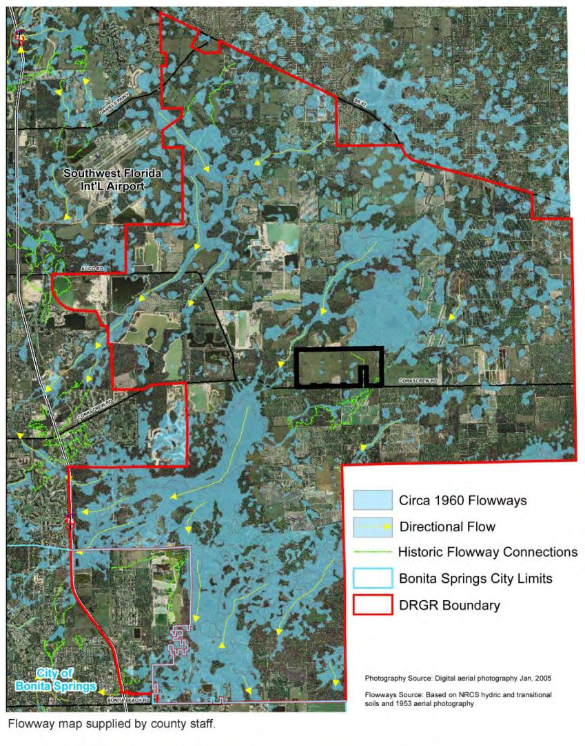
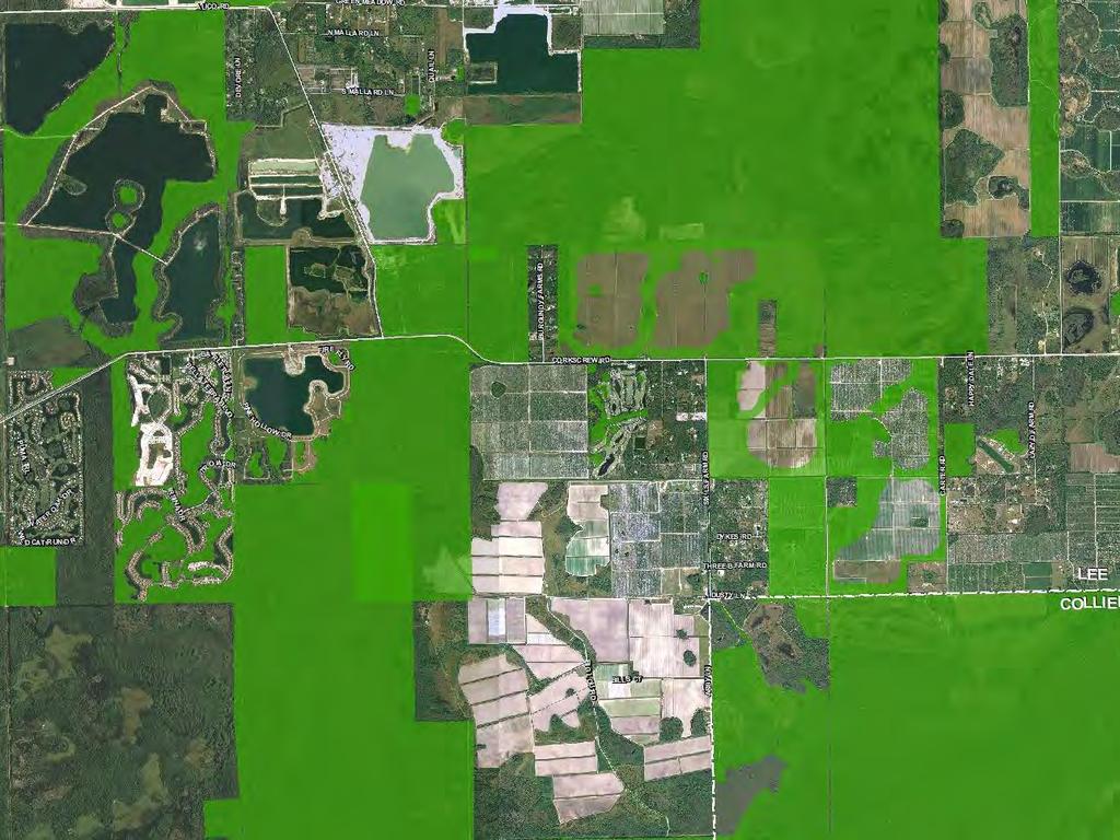
CenterPlace. SW Florida International Airport Cemex Mine. Meridian Center IHub. Gulf Coast Town Center. Miromar Lakes. Youngquist Mine FGCU
|
|
|
- Miranda James
- 6 years ago
- Views:
Transcription


1
2 SW Florida International Airport Cemex Mine Meridian Center IHub Gulf Coast Town Center CenterPlace Miromar Lakes FGCU Youngquist Mine University Highlands Grandezza Corkscrew Woods Preserve at Corkscrew Wildcat Run Bella Terra Stoneybrook
3

4
5
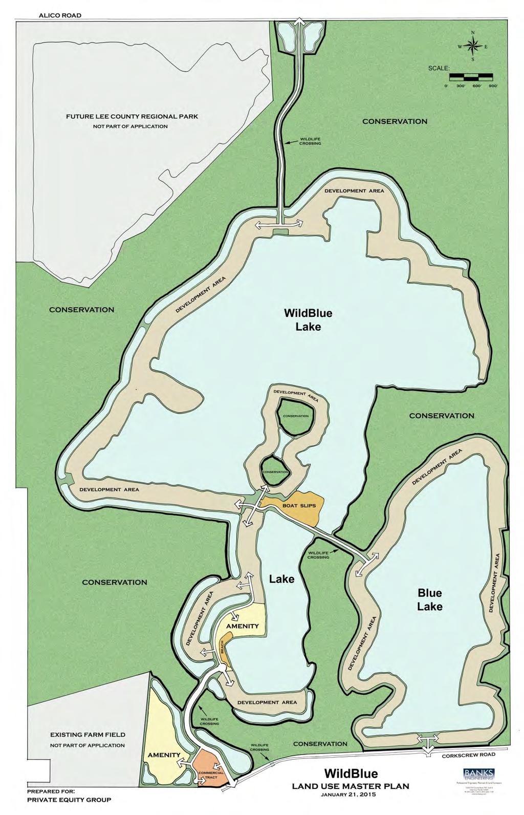
6 WILDBLUE Existing Approvals WildBlue Total Project Acreage 3,552 2,960 Wetland Impact Acreage Protected On-Site Wetlands Total Preserve Acreage 968 1,329 Preserved Panther Habitat 963 1,262 Development Footprint 1, Density 295 single-family 1,100 single-family Utilities Well & Septic Municipal

7
8


9 Regional & Community Benefits that Meet and Exceed DRGR Goals and Objectives Reestablish connectivity of Stewart Cypress Slough to Estero Bay Watershed 1,329+/- acres of restoration and preservation, completed with private funding Creation of two 3-mile long WildLife Corridors 1,262+/- acres of protected primary panther habitat, completed with private funding Improvements to Ground Water Resources 21% reduction in permitted water use Elimination of wells and septic fields; Municipal utilities Improved regional flowway connectivity and hydration Increased storm water capacity No cost to Taxpayers; Privately funded.
10


11 Presentation to: Urban Land Institute A DEVELOPER PERSPECTIVE - ON THE ENVIRONMENTAL ENHANCEMENT OVERLAY Anthony Cameratta, P.E. Vice President Operations April 6, 2018

12 1991 Home-A-Rama People s Choice Award 1993 City of Broadview Heights Beautification Award Homestead Master Planned Community 1994 City of Broadview Heights Beautification Award Country Lakes Master Planned Community 2003 Entrepreneur of the Year Award 2005 Family Business of the Year Award 2006 Family Business of the Year Award 2006 Helping Hand Award for Boys and Girls Club of America Lee County 2007 Family Business of the Year Award 2016 Corkscrew Shores received CBIA Sand Dollar Award 2016 Department of Community Development and American Planning Association Wins Award for The Place at Corkscrew

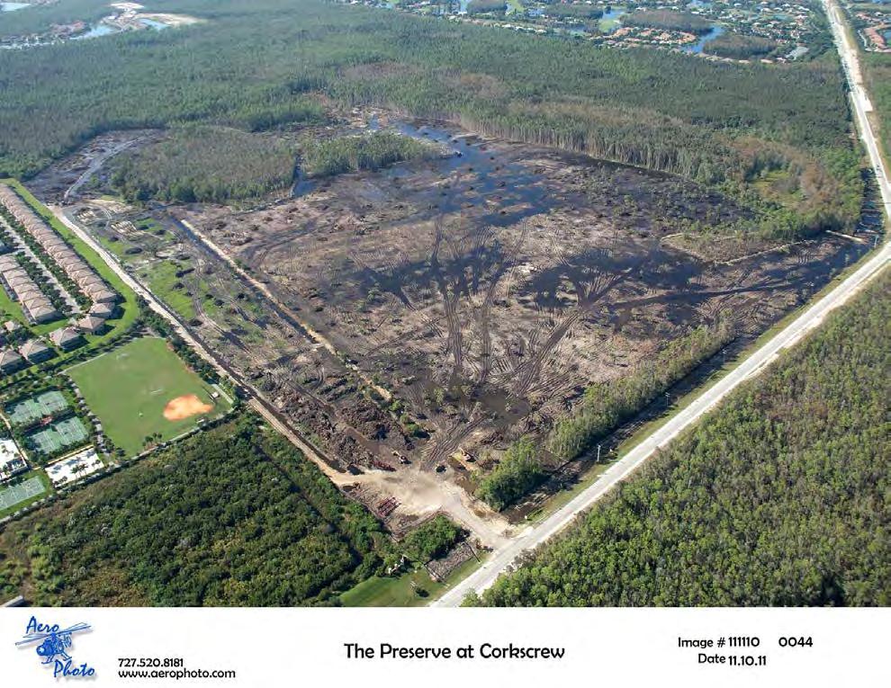
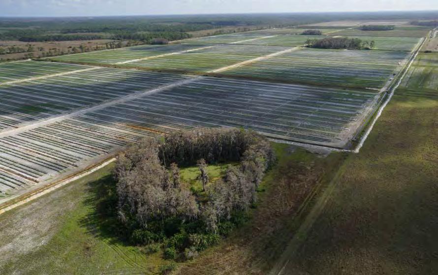
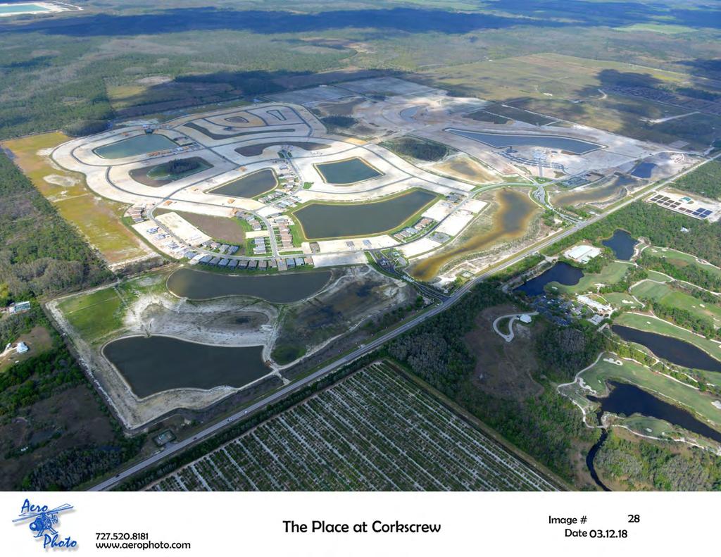
13 THE PLACE AT CORKSCREW 3
14 4
 The Place at Corkscrew $2,000,000 Total Panther Protection Contributions:")
15 Protecting the Florida Panther The Preserve at Corkscrew $1,800,000 Corkscrew Shores $1,174,000 (Panther Crossing) The Place at Corkscrew $2,000,000 Total Panther Protection Contributions: $4,974,000


16 Wildlife and Preservation Corridor
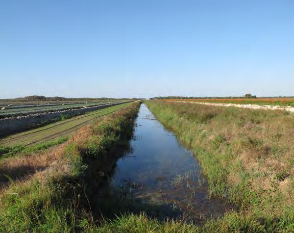
17 Original Approved zoning was for 770 units with an 18 hole golf course. We actually built 441 units WITHOUT a golf course. Total project area is 510 acres, nearly 60% put into Conservation RECORDED Conservation Easements for approximately 300 acres which were restored and now maintained by the 441 residents in perpetuity Provided a more desirable wildlife corridor and surface water flow way, which will provide the new crossing and connectivity to the future WildBlue. Reduced total irrigated area and groundwater needs by eliminating golf course Helps maintain surface and groundwater levels Reuse water is being used as much as possible for irrigation supplementation Littoral shelves, marshes, and other wildlife & water quality beneficial areas were created.


18 CREW Land CREW Land 8

19 9
20 1 st Overlay in the DR/GR in the Corkscrew Corridor working with Environmental Groups including the Conservancy of Southwest Florida Original Approved zoning was for 800 units. 648 units were actually built Eliminated cattle grazing with NO pretreatment into lake/public water supply Cleaned up abandoned mine site of scattered trash, removed exotics, and completed shoreline restoration. Reduced the potential development footprint including roads and single family lots RECORDED Conservation Easements for approximately 114 acres of restored wetlands and uplands to be maintained by the 648 residents in perpetuity Increased conservation lands abutting CREW Reduced total irrigated area and complete control on timing and duration of irrigation Eliminated 254 individual self-supply wells and septic systems Maintains surface and groundwater levels Littoral shelves, marshes, and other wildlife & water quality beneficial areas were created Ground and Surface water quality testing in Perpetuity, NO testing done prior to development


21

22 - This allows a controlled amount of water from the airport mitigation property directly into The Place flow ways, as it historically existed. - Hypothetically, this could lead to potential rerouting of Lake Okeechobee south, instead of the Caloosahatchee River.

23 Airport Mitigation Land 2020 Land Golf Course
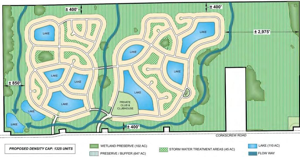
24 Eliminated cattle grazing and farming operations upgradient of public supply wells Cleanup of site including trash and removal of exotics Formally plug/abandon/seal (30) groundwater wells ranging from 2 to 16 in diameter and 15ft to 900ft deep. Reduced development footprint including roads, RECORDED Conservation Easement for 752 acres of the 1,361 acres, which are being restored and will be maintained by the 1,325 residents in perpetuity Increase in conservation lands abutting Airport Mitigation Park to the north and Wetland Mitigation Bank to the east. Reduces total irrigated area, total irrigated quantity, and complete control on timing and duration of irrigation Eliminated potentially 130 individual self-supply wells and septic systems, allowable under previous Comp Plan Helps maintain/improve surface and groundwater levels 50% reduction of nitrogen and phosphorus loads discharged compared to predevelopment testing Installation of littoral shelves, recreation of three historic flow way marshes, and other wildlife corridors & water quality beneficial areas Ground and Surface water quality testing in Perpetuity, NO testing done prior to development Approximately 66% of the land will remain in open space for perpetuity. Approximately 99,500 native trees and 1,778,500 native plants installed in restoration areas.
25 Conservation Goals (DR/GR Overlay): Maintaining and enhancing the surface and groundwater resources Avoiding further loss of wetlands, and requiring any loss of wetlands within the DR/GR to be mitigated within the DR/GR Restoring historic flow-ways Providing connectivity between larger, regionally significant preserves for mammal and herpetofaunal movement Planning for public potable water well withdrawals to insure natural systems are not harmed Restoration of historic ecosystems Maintaining and enhancing wood stork foraging areas 15

26 Flagged and survey located wetland lines Updated FLUCFCS mapping Set nails marking seasonal water levels in the wetlands Installed ground water monitoring wells Lee County Protected Species Survey GPS coordinates for all silt fence protection limits around wetlands Pre-construction wildlife surveys and protection measures as necessary 16

27 Listed Species Documented American alligator Bonneted bat Burrowing owl Crested caracara Florida sandhill crane Little blue heron Big Cypress fox squirrel Florida black bear Royal Fern Woodstork Simpson s zephyrlily Snail Kite William R.Cox 17
28 Surface and Groundwater Monitoring Plan Elements Water Quality Monitoring of Surface Water at Project Outfall (MS-4) Enhanced Lake Management Plan Surface Water Monitoring Plan Groundwater Monitoring Plan 18
29 19
30 Tier 1 lands within the Priority Restoration Strategy will be permitted a maximum density of 1 unit per acre. Density in the Environmental Enhancement and Preservation Overlay is based on the acreage of the entire planned development whether uplands, wetlands, or lake. 20

31 21

32 Environmental Perspective SHANE JOHNSON, SENIOR ECOLOGIST
33 Policy Properties that provide significant regional hydrological and wildlife connection have the potential to improve, preserve, and restore regional surface and groundwater resources and indigenous wildlife habitat As an incentive to improve, preserve, and restore regional surface and groundwater resources and wildlife habitat of state and federally listed species, additional densities and accessory commercial uses will be granted

34 Policy Environmental Enhancement and Preservation Communities Overlay (Overlay) Map 17 3
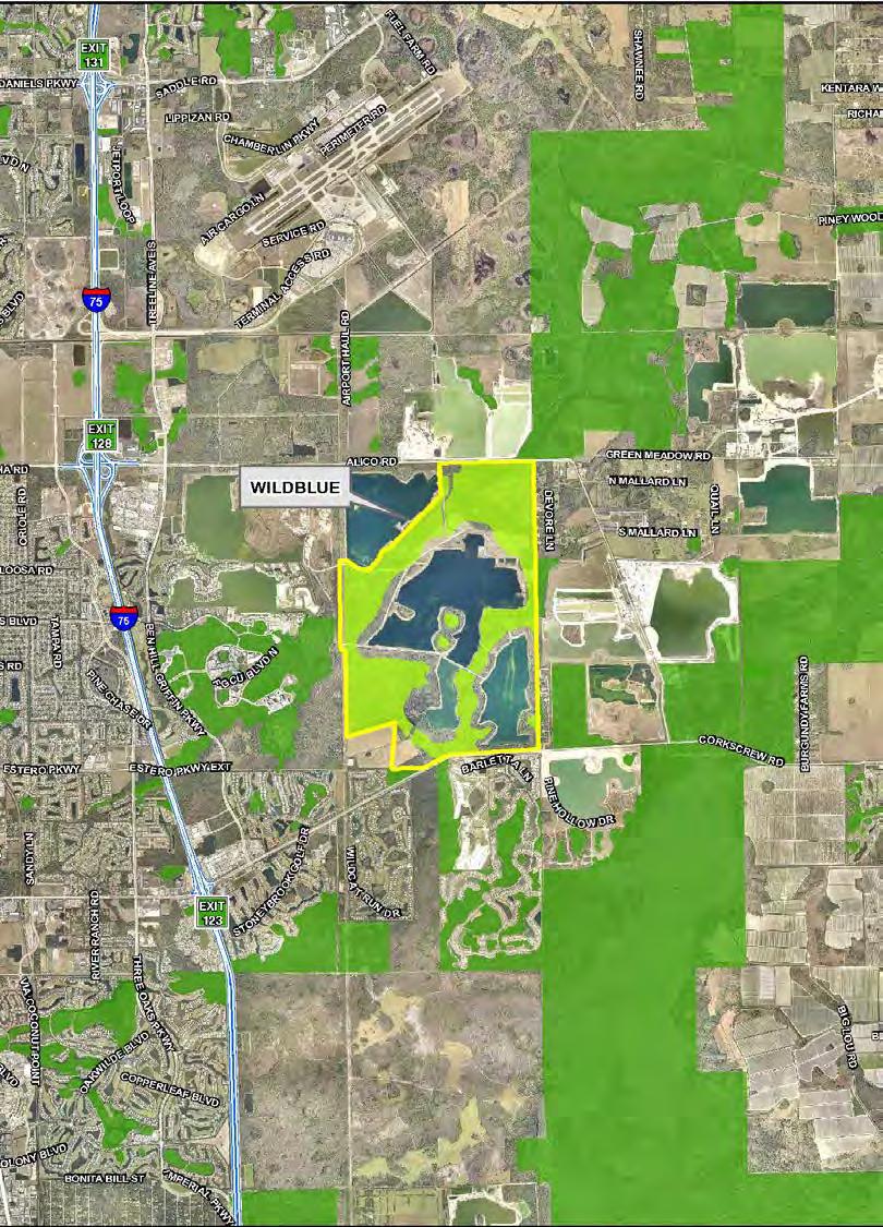
35 Policy Provide a minimum of 60% open space Record a conservation easement for a minimum of 55% of the property Restore and accommodate existing and historic regional flow-ways where they currently or previously existed Restore and accommodate existing and historic groundwater levels
36 Policy Restore and preserve wetlands Restore and preserve indigenous upland habitats Provide critical wildlife connections to adjacent conservation areas Prepare a detailed management plan that addresses indigenous vegetation restoration and human-wildlife coexistence

37 6

38 Existing Condition 7

39 Restored Condition 8


40 Hydrologic and Water Quality Improvements 9 Backfill ditches Eliminate Ag pumping and irrigation activities Eliminate the use of pesticides and herbicides Removal of cattle

41 Increase Wildlife Habitat 10

42 Conservation Lands Prior to Overlay 11

43 First Overlay Project WildBlue 12

44 Second Overlay Project The Place at Corkscrew 13

45 Third Overlay Project Pepperland Ranch 14

46 Fourth Overlay Project Verdana 15
47 Ecological Benefits 16 Preservation, enhancement, and restoration of >3,200 acres of indigenous habitat Restoration of historic hydrologic conditions Enhance and restore surface and groundwater resources Eliminate farming activities Improve water quality 55% of the total Project area will be preserved and placed under conservation easement Restoration of historic flowways Provide increased wildlife habitat and connection to adjacent conservation lands Long-term maintenance in perpetuity of preserve areas Restoration of historic ecosystems Increased foraging habitat for wading birds


48 Thank You!
Kevin L. Erwin CE PWS Kevin L. Erwin Consulting Ecologist, Inc Bayside Parkway Ft. Myers, Florida USA
 Kevin L. Erwin CE PWS Kevin L. Erwin Consulting Ecologist, Inc. 2077 Bayside Parkway Ft. Myers, Florida 33901 USA The Lee County DR/GR: Implications for future restoration and management Estero Bay Watershed
Natural Resource Value of Edison Farms/Agripartners. Presented by: Jessica Stubbs, Natural Resources Specialist
 Natural Resource Value of Edison Farms/Agripartners Through Research and Science Presented by: Jessica Stubbs, Natural Resources Specialist Introduction to Edison Farms Almost 4,000 acres Within Estero
CPA CORKSCREW WOODS PRIVATELY SPONSORED AMENDMENT TO THE LEE COUNTY COMPREHENSIVE PLAN THE LEE PLAN
 CPA2011-18 CORKSCREW WOODS PRIVATELY SPONSORED AMENDMENT TO THE LEE COUNTY COMPREHENSIVE PLAN THE LEE PLAN LPA Public Hearing Document For the April 23 rd, 2012 Public Hearing Lee County Planning Division
APPENDIX B BACKGROUND INFORMATION REGARDING DENSITY REDUCTION/GROUNDWATER RESOURCE (DR/GR) AREA LEE COUNTY, FLORIDA
 AREA LEE COUNTY, FLORIDA") APPENDIX B BACKGROUND INFORMATION REGARDING DENSITY REDUCTION/GROUNDWATER RESOURCE (DR/GR) AREA LEE COUNTY, FLORIDA APPENDIX B Background Information Regarding Density Reduction / Groundwater Resource
APPENDIX B BACKGROUND INFORMATION REGARDING DENSITY REDUCTION/GROUNDWATER RESOURCE (DR/GR) AREA LEE COUNTY, FLORIDA APPENDIX B Background Information Regarding Density Reduction / Groundwater Resource
DEPARTMENT OF THE ARMY JACKSONVILLE DISTRICT CORPS OF ENGINEERS PRINCESS PALM AVENUE, SUITE 120 TAMPA, FLORIDA
 DEPARTMENT OF THE ARMY JACKSONVILLE DISTRICT CORPS OF ENGINEERS 10117 PRINCESS PALM AVENUE, SUITE 120 TAMPA, FLORIDA 33610 REPLY TO ATTENTION OF May 8, 2015 Regulatory Division South Permits Branch Tampa
Technical Memorandum
 An Atkins Company Technical Memorandum To: From: Mac Hatcher, PM Collier County Moris Cabezas, PBS&J Ed Cronyn, PBS&J Date: Re: Watershed Model Update Contract 08-5122, PO 4500106318 Element 4, Task 1,
1. GENERAL DESCRIPTION OF LAND USE / COVER TYPES (SEE GENERAL DESCRIPTIONS ON PAGE 7) A 2. ADJACENT LANDS & EASEMENTS 3. FAMILY AGRICULTURAL LEGACY
 A 2. ADJACENT LANDS & EASEMENTS 3. FAMILY AGRICULTURAL LEGACY") CONSERVATION EASEMENT PROJECT: COUNTY: NAME OF LANDOWNER: CELL/OFFICE PHONE: NAME OF FARM / SITE MANAGER: CELL/OFFICE PHONE: GENERAL DESCRIPTION OF LAND USE / COVER TYPES (SEE GENERAL DESCRIPTIONS ON PAGE
CONSERVATION EASEMENT PROJECT: COUNTY: NAME OF LANDOWNER: CELL/OFFICE PHONE: NAME OF FARM / SITE MANAGER: CELL/OFFICE PHONE: GENERAL DESCRIPTION OF LAND USE / COVER TYPES (SEE GENERAL DESCRIPTIONS ON PAGE
(1)(A)Inventory of the following existing natural resources on the USFSP Campus or within the context area adjacent to the University.
(A)Inventory of the following existing natural resources on the USFSP Campus or within the context area adjacent to the University.") 13. 6C-21.208 CONSERVATION ELEMENT Information Sources George F. Young, Interview notes, June 2002 Sasaki Associates, Inc., interview notes, April, 2000 Interviews between DRMP Staff and USF Staff, May,
13. 6C-21.208 CONSERVATION ELEMENT Information Sources George F. Young, Interview notes, June 2002 Sasaki Associates, Inc., interview notes, April, 2000 Interviews between DRMP Staff and USF Staff, May,
SW-74 SERENOVA PRESERVE SITES 2, 3, 4, 8 MITIGATION PLAN
 SW-74 SERENOVA PRESERVE SITES 2, 3, 4, 8 MITIGATION PLAN BACKGROUND INFORMATION Project SWIM? Aquatic Control? Exotic Control? Mitigation Bank? Type No No No No Mitigation Restoration and enhancement Type
Options for Reducing Harmful Lake Okeechobee Discharges and Everglades Restoration
 Options for Reducing Harmful Lake Okeechobee Discharges and Everglades Restoration The Florida Senate Appropriations Subcommittee on the Environment and Natural Resources January 11, 2017 Gary Goforth,
Chapter 10 Natural Environment
 Chapter 10 Natural Environment Existing Conditions The Natural Environment Element addresses the protection, conservation, preservation, and restoration of the natural resources the Bayview Ridge Subarea,
STREAM AND BUFFER AREA PROTECTION/RESTORATION
 STREAM AND BUFFER AREA PROTECTION/RESTORATION AMENDMENT OPTIONS TO STRENGTHEN POLICY IN HEADWATERS AREAS DRAFT SUBSEQUENT TO THE JANUARY 25, 2007 MEETING OF THE PLANNING COMMISSION ENVIRONMENT COMMITTEE
CENTRAL AND SOUTHERN FLORIDA PROJECT COMPREHENSIVE EVERGLADES RESTORATION PLAN SITE 1 IMPOUNDMENT PROJECT FINAL SUPPLEMENTAL ENVIRONMENTAL ASSESSMENT
 CENTRAL AND SOUTHERN FLORIDA PROJECT COMPREHENSIVE EVERGLADES RESTORATION PLAN SITE 1 IMPOUNDMENT PROJECT FINAL SUPPLEMENTAL ENVIRONMENTAL ASSESSMENT June 2010 CENTRAL AND SOUTHERN FLORIDA PROJECT SITE
Mud Lake Lakeshed Assessment
 Mud Lake Lakeshed Assessment The lakeshed vitals table identifies where to focus organizational and management efforts for each lake. Criteria were developed using limnological concepts to determine the
POLICY FOR NATURAL RESOURCE MANAGEMENT AREAS
 POLICY FOR NATURAL RESOURCE MANAGEMENT AREAS I. POLICY STATEMENT Auburn University's (the University's) "Policy for Natural Resource Management Areas" implements the Campus Master Plan Land Use Element
PINELLAS COUNTY RESTORE ACT DIRECT COMPONENT PROJECTS IDEAS SUBMITTED TO PINELLAS COUNTY
 RESTORE ACT DIRECT COMPONENT S DATE RECEIVED: 7/7/14 NAME: : Tides Golf Course Acquisition & Restoration Purchase ~90 acre property, retrofit stormwater systems, restore habitat, create trials and boardwalks.
SRCD s Review of Impacts the Proposed Bay Delta Conservation Plan (BDCP) and Companion EIR/EIS on the Suisun Marsh
 and Companion EIR/EIS on the Suisun Marsh") SRCD s Review of Impacts the Proposed Bay Delta Conservation Plan (BDCP) and Companion EIR/EIS on the Suisun Marsh By Steve Chappell, Executive Director Suisun RCD BDCP Document is Extremely Challenging
SRCD s Review of Impacts the Proposed Bay Delta Conservation Plan (BDCP) and Companion EIR/EIS on the Suisun Marsh By Steve Chappell, Executive Director Suisun RCD BDCP Document is Extremely Challenging
Subject: WUP Integrated Water Use Permit (IWUP) Annual Water Conservation Progress Report (AWCPR)
 Annual Water Conservation Progress Report (AWCPR)") Kacie Blue Sr. Environmental Specialist Mosaic Fertilizer, LLC 13830 Circa Crossing Drive Lithia, FL 33547 Tel (813) 500-6656 Fax (813) 571-6908 E-mail: kacie.blue@mosaicco.com www.mosaicco.com June 1,
Kacie Blue Sr. Environmental Specialist Mosaic Fertilizer, LLC 13830 Circa Crossing Drive Lithia, FL 33547 Tel (813) 500-6656 Fax (813) 571-6908 E-mail: kacie.blue@mosaicco.com www.mosaicco.com June 1,
Science Plan. Executive Summary. Introduction
 Science Plan Executive Summary This Science Plan will establish and define the focus of the Peninsular Florida Landscape Conservation Cooperative (PFLCC) science investments. The data and products derived
STREAM RESTORATION PURPOSE, PRACTICE, AND METHODS. By Marcus Rubenstein, CPESC
 STREAM RESTORATION PURPOSE, PRACTICE, AND METHODS By Marcus Rubenstein, CPESC WHAT IS STREAM RESTORATION? The return of a stream s lost natural functions, usually resulting from watershed alterations,
Palm Beach County Project, LLC
 Palm Beach County Project, LLC February 9, 2011 Agenda Introductions Wind Capital Group Four basics of a wind farm Why Florida? Environmental Process How we build a wind farm Wind Capital Group Independently
 The Yolo Natural Heritage Program Interface with the Bay Delta Conservation Plan Background, Summary, and Remaining Issues May 23, 2013 Background The Yolo Natural Heritage Program (Yolo HCP/NCCP) and
Intermittent Stream Reclamation
 Reclamation About Mosaic Reclamation > In carrying out its mission to help the world grow the food it needs, Mosaic couples recovery of phosphate resources with respect of the phosphate-rich land that
Estero Bay Watershed Assessment
 Estero Bay Watershed Assessment Volume D: - Draft Report - Prepared for: South Florida Water Management District P.O. Box 24680 3301 Gun Club Road West Palm Beach, Florida 33416-4680 Prepared by: PBS&J,
Clean water. From nature.
 Clean water. From nature. Natural Treatment System Save water. Do your part. Did you know that over watering or a broken sprinkler on your property can contribute to ocean pollution? Excess watering creates
VILLAGE OF BELLAIRE WATER QUALITY ACTION PLAN
 VILLAGE OF BELLAIRE WATER QUALITY ACTION PLAN Elk-River-Chain-of-Lakes Gaps Analysis Project The Watershed Center Grand Traverse Bay Tip of the Mitt Watershed Council Michigan Department of Natural Resources
Will be modified map from GIS 6/16 EOD
 Middle-Snake-Tamarac Rivers Watershed District Judicial Ditch #19 Watershed Regional Conservation Partnership Program (RCPP) Public Scoping Meeting September 26, 2016 Will be modified map from GIS 6/16
FieldDoc.org User Guide For 2017 NFWF Chesapeake Bay Stewardship Fund Applicants. Background 2. Step 1: Register for a FieldDoc account 3
 FieldDoc.org User Guide For 2017 NFWF Chesapeake Bay Stewardship Fund Applicants Table of Contents (click to go to page) Background 2 Step 1: Register for a FieldDoc account 3 Step 2: Create the Project
Aquatic Fish and Wildlife Habitat Management
 Aquatic Fish and Wildlife Habitat Management Tier 2 Worksheet Community Environmental Management 303 Acknowledgements The New York State Soil and Water Conservation Committee and Department of Environmental
Project Goals and Scoping
 Prepared for: Boulder County, Colorado Flood Planning & Preliminary Design Services for South St. Vrain Creek Restoration at Hall Ranch and Scoping May 24, 2016 Meeting with General Public In association
PHYSICAL ENVIRONMENT FUNCTION Natural Resources Department
 Director s Background James T. Evans III, M.S. PHYSICAL ENVIRONMENT FUNCTION Natural Resources Department Director Evans has been employed with the City of Sanibel for more than 14 years and has over 17
Florida Department of Environmental Protection
 Memorandum Florida Department of Environmental Protection To: Highlands Ranch Mitigation Bank permit application File No. 10-308703-001 From: Connie Bersok Re: May 9, 2012 status memo On May 8, Tim Rach
Restoration and Protection of the Water Resources of the Greenwood Lake Watershed in New Jersey
 Restoration and Protection of the Water Resources of the Greenwood Lake Watershed in New Jersey Greenwood Lake Commission Bi-state commission that was formed in 2001 for the express purpose of improving
WATERSHED MANAGEMENT INITIATIVE: GOALS & IMPLEMENTATION OBJECTIVES, JULY 26, 1999
 WATERSHED MANAGEMENT INITIATIVE: GOALS & IMPLEMENTATION OBJECTIVES, JULY 26, 1999 The following table indicates the draft goals and objectives for the Santa Clara Basin WMI process. The overall objectives
Habitat Grant Projects Clinton River Watershed
 Habitat Grant Projects Clinton River Watershed L Y N N E S E Y M O U R E N V I R O N M E N T A L E N G I N E E R O F F I C E O F T H E M A C O M B C O U N T Y P U B L I C W O R K S C O M M I S S I O N
PROJECT INFORMATION Manchester Ranger District Apple Tree Release and Maintenance Project
 PROJECT INFORMATION Manchester Ranger District Apple Tree Release and Maintenance Project The USDA Forest Service is proposing to release and prune living apple trees in the Manchester Ranger District,
C-111 Spreader Canal Project: A Unique Example of Public Involvement and Adaptive Management in Everglades Restoration
 C-111 Spreader Canal Project: A Unique Example of Public Involvement and Adaptive Management in Everglades Restoration INTERCOL 9 June 7, 2012 Kenneth G. Ammon, P.E. Senior Vice President Overview South
Corporate Environmental Water Stewardship Go Green. Todd Reeve October 17, 2017
 Corporate Environmental Water Stewardship Go Green Todd Reeve October 17, 2017 Freshwater & Business Risk #1 threat (World Economic Forum 2016) 2/3 rd of companies report water as substantive risk* 44%
State of Florida Department of Community Affairs Areas of Critical State Concern Implementation Status Report Apalachicola Bay Area
 State of Florida Department of Community Affairs Areas of Critical State Concern Implementation Status Report Apalachicola Bay Area Thaddeus L. Cohen, AIA Secretary November 2006 CONTENTS Part 1 - Summary
Successful Floodplain Reconnection
 Successful Floodplain Reconnection Design, Implementation, Monitoring and Adaptive Management Upper Truckee River, Lake Tahoe, California Michael Rudd, PE, Charley Miller PE, Virginia Mahacek, Chad Krofta
Chapter 13: Wildlife and Vegetation
 Chapter 13: Wildlife and Vegetation Introduction and Setting Nevada County contains an extremely wide range of plants, animals and habitat types. With topographic elevations ranging from 300 feet in the
WATERSHED. Maitland Valley. Report Card 201
 Maitland Valley WATERSHED Report Card 201 The Maitland Valley Conservation Authority has prepared this report card as a summary on the state of our forests, wetlands, surface water, and ground water resources.
Chapter 4 Watershed Goals and Objectives
 Chapter 4 Watershed Goals and Objectives Eight (8) long-term watershed goals have been developed by the NEW Watershed Advisory Group (WAG) after consideration of discussions held during monthly watershed
Indirect Reuse with Multiple Benefits The El Monte Valley Mining, Reclamation, and Groundwater Recharge Project
 ABSTRACT & POWERPOINT PRESENTATION Indirect Reuse with Multiple Benefits The El Monte Valley Mining, Reclamation, and Groundwater Recharge Project Tim Smith Principal Engineer Helix Water District La Mesa,
Stormwater as an Alternative Source of Water Supply: Feasibility and Implications for Watershed Management 1
 CIR1493 Stormwater as an Alternative Source of Water Supply: Feasibility and Implications for Watershed Management 1 Sanjay Shukla and Fouad H. Jaber 2 Introduction: Florida s Water Supply Florida is projected
Watersheds Functions and Management 1
 Fact Sheet ABE350 Watersheds Functions and Management 1 S. Shukla 2 What Is a Watershed? The term watershed is often used in discussions about water quality or flood prevention, but most people do not
Altamonte Springs FDOT I-4 Storm water Capture and Reclaimed Water Project Phase I
 St. Johns River Water Management District Wekiva Spring Altamonte Springs FDOT I-4 Storm water Capture and Reclaimed Water Project Phase I Project includes construction of a 5.8 mile 20-inch diameter reclaimed
CHAPTER 5: CONSERVATION ELEMENT
 CHAPTER 5: CONSERVATION ELEMENT This section stipulates goals, objectives, and implementing policies for the Conservation Element pursuant to 163.3177(6)(d),F.S., and 9J-5.013, F.A.C. GOAL 5.1: CONSERVATION.
719 Griswold, Suite 820 Detroit, MI DANVERS POND DAM REMOVAL AND STREAM RESTORATION PROJECT
 Great Lakes Restoration Initiative Grant Final Report US EPA Grant GL 00E006 43 October, 2013 Valley Woods Wetland Southfield Lola Valley Grow Zone Wayne County Parks Venoy Park Grow Zone Wayne County
Proposed Wetland Restoration Case Study Submittal
 Proposed Wetland Restoration Case Study Submittal 1. Project Name and Location: Little Pine Island Coastal Habitat Restoration Lee County, Florida, USA Latitude 26 37'1.39"N Longitude 82 5'23.42"W 2. Wetland
STATE OF ALASKA DEPARTMENT OF NATURAL RESOURCES DIVISION OF MINING, LAND AND WATER LAND USE PERMIT APPLICATION AS
 STATE OF ALASKA DEPARTMENT OF NATURAL RESOURCES DIVISION OF MINING, LAND AND WATER LAND USE PERMIT APPLICATION AS 38.05.850 Applicants must complete all sections of this application. In addition, applicants
Linking TEK, Outreach, and Science to Protect Everglades Wetlands. Water Resources Department Marta Reczko, Water Resources Manager
 Linking TEK, Outreach, and Science to Protect Everglades Wetlands Water Resources Department Marta Reczko, Water Resources Manager Everglades Facts The Everglades is a marsh, a region, a watershed, an
TORCH LAKE TOWNSHIP WATER QUALITY ACTION PLAN
 TORCH LAKE TOWNSHIP WATER QUALITY ACTION PLAN Elk-River-Chain-of-Lakes Gaps Analysis Project The Watershed Center Grand Traverse Bay Tip of the Mitt Watershed Council Michigan Department of Natural Resources
Natural Treatment Systems A Water Quality Match for Oregon s Cities and Towns
 Oregon Natural Treatment Systems for Wastewater Natural Treatment Systems A Water Quality Match for Oregon s Cities and Towns June, 2014 Oregon Department of Environmental Quality 1 Natural Treatment Systems
RIPARIAN PROTECTION Questions & Answers
 RIPARIAN PROTECTION Questions & Answers 1. What is a riparian corridor and why is it important? Answer: A riparian corridor is a space on both sides of a stream or around a lake or wetland. The corridor
CITY OF MOUNTAIN VIEW
 CITY OF MOUNTAIN VIEW Incorporate Climate Change Adaptation in Municipal Scale, Urban Watershed Planning at the City of Mountain View Raymond Wong, PhD, PE, LEED AP Lisa Au, PE Floodplain Management Association
Alico Road. Connector Study. Lee County Department of Transportation. Prepared by. Lee County, Florida
 Alico Road Connector Study Lee County Department of Transportation Lee County, Florida Prepared by July 2009 TABLE OF CONTENTS SECTION PAGE 1.0 INTRODUCTION... 1 1.1 Project Description and Purpose...
Duwamish Waterway Self Guided Tour: Turning Basin Number Three and Terminal 105 Aquatic Habitat Restoration Sites
 Duwamish Waterway Self Guided Tour: Turning Basin Number Three and Terminal 105 Aquatic Habitat Restoration Sites Text and illustrations in the following pages include: (1) summary information describing
Central Coast Water Board Agricultural Order R Angela Schroeter Agricultural Regulatory Program
 Central Coast Water Board Agricultural Order R3-2012-0011 Angela Schroeter Agricultural Regulatory Program Background Photo: Morro Bay, CA Overview Role of the Water Board Agricultural Order R3-2012-0011
Wildlife Management Intensity Standards
 Habitat Control Practices Required Intensity Description Grazing Management The planned manipulation of livestock numbers and grazing intensities to increase food, The planned manipulation of livestock
Long Island s. Environmental Issues. Environmental Issues. Environmental Setting. Environmental Setting. Suburbia and the Environment
 Environmental Issues Long Island s Environmental Issues Copyright 2011 AFG 1 agricultural land air pollution aquifers automobile barrier islands biozones fisheries groundwater recharge invasive species
WETLANDS AND OPEN WATERS Compensatory Mitigation Definitions of Factors
 Adverse effects as used in this section of the SOP means any adverse ecological effect on wetlands or areas of open water. Those effects, or impacts, include filling, excavating, flooding, draining, clearing,
Solano Multi-Species Habitat Conservation Plan
 Solano Multi-Species Habitat Conservation Plan 580,000 Acres 37 Covered Species 4 Natural Communities 12,000 acres of Proposed Development Approximately 23,000 acres will be Preserved Plan Participants
P ARISH OF EAST B ATON ROUGE, L OUISIANA BREC S TRATEGIC P LAN
 CHAPTER 9 CULTURAL, HISTORICAL AND NATURAL RESOURCE MANAGEMENT PLAN INTRODUCTION This chapter is a digest version of a Natural Resource, Cultural and Historical Document authored by BREC Staff over the
Environmental Information Worksheet
 Environmental Information Worksheet Water System Owner (Attach additional sheets if necessary) Needs and Alternatives Provide a brief narrative that describes: Current drinking water system needs. Project
Calculating Mitigation
 US Army Corps of Engineers Jacksonville District Calculating Mitigation Lift Loss 1 US Army Corps of Engineers Jacksonville District Under the U.S. Army Corps of Engineers Regulatory Program, mitigation
$5 Million Enviva Forest Conservation Fund Announces 2016 Conservation Grants
 FOR IMMEDIATE RELEASE Enviva contact: U.S. Endowment contact: Kent Jenkins Jr. Carlton Owen Vice President, Communications President and CEO 240.482.3811 864.233.7646 kent.jenkins@envivabiomass.com carlton@usendowment.org
A Salt Marsh Advancement Zone Assessment of West Haven, Connecticut
 A Salt Marsh Advancement Zone Assessment of West Haven, Connecticut Front cover image: Open space and unprotected parcels critical to the conservation of marsh advancement corridors in West Haven; from
STORMWATER HARVESTING FOR ALTERNATIVE WATER SUPPLY IN VOLUSIA COUNTY, FLORIDA
 STORMWATER HARVESTING FOR ALTERNATIVE WATER SUPPLY IN VOLUSIA COUNTY, FLORIDA Lena Rivera, P.E., D.WRE (CDM); Lee P. Wiseman, P.E., BCEE (CDM); Scott Mays, P.E. (Volusia County); and George Recktenwald
Environment & Conservation Introduction
 Environment & Conservation Introduction Anacortes is blessed with an abundance of natural beauty. Residents identify marine shorelines, streams, lakes, forested areas, and other natural features as defining
NJDEP Regulations that impact or soon will impact agricultural operations. April 1, 2007 Horses 2007
 NJDEP Regulations that impact or soon will impact agricultural operations. April 1, 2007 Horses 2007 Peter L. Kallin, Ph.D., P.W.S. Phone: 732-499-3600 Ext. 237 E-mail: pkallin@aesop.rutgers.edu www.water.rutgers.edu
University of Florida Conservation Areas Land Management Plan Trillium Slope (Golf Course Woods)
") University of Florida Conservation Areas Land Management Plan Trillium Slope (Golf Course Woods) Introduction Trillium Slope (Golf Course Woods) is a 4.9-acre Conservation Area named after a plant that
University of Florida Conservation Areas Land Management Plan Trillium Slope (Golf Course Woods) Introduction Trillium Slope (Golf Course Woods) is a 4.9-acre Conservation Area named after a plant that
Municipal Stormwater Management Planning
 Municipal Stormwater Management Planning Christopher C. Obropta, Ph.D., P.E. Water Resources Extension Specialist with Rutgers Cooperative Extension Assistant Professor with Department of Environmental
HEADQUARTERS WEST LTD. FARM, RANCH, AGRIBUSINESS REAL ESTATE SALES & SERVICES
 Offered For Sale HUNT VALLEY RANCH Apache County, Arizona Exclusively Listed By: Traegen Knight Headquarters West, Ltd. P.O. Box 1980 St. Johns, Arizona 85936 Ph. 928 524-3740 Fx. 928 563-7004 Hunt Valley
City of Bonita Springs Comprehensive Plan
 Comprehensive Plan Adoption Date: December 25, 2002 Amended: June 1, 2005 December 6, 2006 March 7, 2007 September 3, 2008 September 17, 2008 February 18, 2009 April 15, 2009 Prepared by Coordination and
SECTION 3 NATURAL RESOURCES
 SECTION 3 NATURAL RESOURCES The natural environment plays a large role in planning for future development. Environmental conditions, such as topography, wetlands, floodplains, and water bodies, can often
Hello my name is Joy Loughry and I am with the groundwater technical unit of the Minnesota department of natural resources. Today I am going to talk
 Hello my name is Joy Loughry and I am with the groundwater technical unit of the Minnesota department of natural resources. Today I am going to talk about how the state of Minnesota manages its Water resources
Water Assessment and Audit. Congratulations on completing Step 1 by forming your Green Team!
 School Name: Date: Conducted By: Congratulations on completing Step 1 by forming your Green Team! Step 2: Assess Complete this to learn more about the current water conservation and quality practices at
South Florida Water Management District Future Directions. Melissa Meeker, Executive Director
 South Florida Water Management District Future Directions Melissa Meeker, Executive Director September 15, 2011 District Overview Oldest and largest of five water management districts Covers 18,000 square
ECOSYSTEMS, WATERSHEDS AND POLLUTION CONTROL REVIEW
 ECOSYSTEMS, WATERSHEDS AND POLLUTION CONTROL REVIEW ECOSYSTEMS: (6 th grade content) How biotic and abiotic factors make an ecosystem: https://www.youtube.com/watch?v=mdlwptkg-vi 1. A/An ecosystem is a
Our Eastern Shore Groundwater Part IV Groundwater Quality on the Eastern Shore: How safe is our groundwater and are there ways we can protect it?
 Our Eastern Shore Groundwater Part IV Groundwater Quality on the Eastern Shore: How safe is our groundwater and are there ways we can protect it? Britt McMillan, Malcolm Pirnie, Inc. Mercury Venus Mars
Shoreland Rules Revision Project Using GIS in North-Central Minnesota
 Shoreland Rules Revision Project Using GIS in North-Central Minnesota Andrew J. Williquett Department of Resource Analysis, Saint Mary s University of Minnesota, Minneapolis, MN 55404 Keywords: GIS, docks,
BMPs TO CONSERVE WOODED AREAS AT THE SUBDIVISION LEVEL
 BMPs to Conserve Wooded Areas 31 BMPs TO CONSERVE WOODED AREAS AT THE SUBDIVISION LEVEL Audience This section is primarily directed toward: local units of government, landowners and developers, builders
Sovereign Lands and Great Salt Lake
 Sovereign Lands and Great Salt Lake The Living Lake - Charles Uibel Laura Ault Sovereign Lands Program Manager Division of Forestry, Fire and State Lands What are Sovereign Lands? Lakebeds and riverbeds
Riparian Buffers and Stream Restoration
 Riparian Buffers and Stream Restoration Why focus on riparian areas? Link land and water on any given site and link landscapes together in a watershed Riparian corridors protect the circulatory system
Verbal Interim Progress Report Jim Beever October 25, 2017
 Verbal Interim Progress Report Jim Beever October 25, 2017 The Southwest Florida Regional Planning Council (SWFRPC) is assisting the City of Bonita Springs in developing a City of Bonita Springs Flooding
Lake Britton Planning Unit. Fish, Plant, and Wildlife Habitat LAKE BRITTON PLANNING UNIT
 LAKE BRITTON PLANNING UNIT Pit-McCloud River Watershed Lake Britton Planning Unit Fish, Plant, and Wildlife Habitat Conduct surveys of lands outside the FERC boundary to identify biological resources and
Climate Sensitivity Runs (DRAFT)
") Climate Sensitivity Runs (DRAFT) South Florida Water Management Model SOUTH FLORIDA WATER MANAGEMENT DISTRICT February 13, 2013 Authored by: Hydrologic & Environmental Systems Modeling (HESM) Contributors:
Climate Sensitivity Runs (DRAFT) South Florida Water Management Model SOUTH FLORIDA WATER MANAGEMENT DISTRICT February 13, 2013 Authored by: Hydrologic & Environmental Systems Modeling (HESM) Contributors:
Lisa B. Beever, PhD, AICP Estero Bay Agency on Bay Management Cela Tega December 12, 2016
 Lisa B. Beever, PhD, AICP Estero Bay Agency on Bay Management Cela Tega December 12, 2016 National Estuary Programs Each of the 28 NEP logos represents broad local partnerships which include citizens,
Township of Washington Master Plan Highlands Element Exhibit A:
 Exhibit A: Regional Master Plan Overlay Zone Designation Zone Protection Lakes Greater Than 10 acres Conservation Existing Community Sub-Zone Existing Community Environmentally Constrained Conservation
Polluted Runoff and Land Conservation: What s the Connection?
 Polluted Runoff and Land Conservation: What s the Connection? Caroly Shumway, Ph.D. Executive Director, Merrimack River Watershed Council In partnership with NMCOG Overview Purpose Of This Talk Is To Convey
SOUTH FLORIDA WATER MANAGEMENT DISTRICT. Question 13: Wetlands
 SOUTH FLORIDA WATER MANAGEMENT DISTRICT Question 13: Wetlands 1. The wetland responses and topographical data provided in the ADA for the 520- acre project site are conceptual in nature. The referenced
Go Green, Save Money: Lowering Flood Insurance Rates in Virginia with Stormwater Management. Kristen Clark VCPC Alumna, Spring 2014
 Go Green, Save Money: Lowering Flood Insurance Rates in Virginia with Stormwater Management Kristen Clark VCPC Alumna, Spring 2014 Rising Waters, Rising Rates Coastal Communities in Virginia are confronted
USDA Forest Service Lake Tahoe Basin Management Unit Forest Plan Revision Topics Need for Change
 USDA Forest Service Lake Tahoe Basin Management Unit Forest Plan Revision Topics Need for Change This revised report accompanies the Forest Service Need for Change discussion, and is intended to clarify
Wetlands Project Guidance
 HABITAT Wetlands Project Guidance Stakeholder Informed Introduction Wetlands are lands saturated with water permanently or seasonally. Wetlands are typically defined by three characteristics: 1) The area
NDCEE. Ecosystem Banking Best Practices. Elizabeth Keysar, NDCEE/CTC. National Defense Center for Energy and Environment
 NDCEE Ecosystem Banking Best Practices DoD Executive Agent Office Office of the of the Assistant Assistant Secretary of the of Army the Army (Installations and and Environment) Elizabeth Keysar, NDCEE/CTC
The Orlando Easterly Wetlands: Strategies for Prolonging Phosphorus Removal
 The Orlando Easterly Wetlands: Strategies for Prolonging Phosphorus Removal Mark D. Sees Wetlands Manager Orlando Easterly Wetlands 1.6 km or 1 mile Went on-line in July of 1987 Constructed on cattle
Request for Proposals Surface Water Improvement Fund Grants CUYAHOGA COUNTY ONLY 12/01/09
 STREET ADDRESS: Lazarus Government Center 50 W. Town St., Suite 700 Columbus, Ohio 43215 State of Ohio Environmental Protection Agency TELE: (614) 644-3020 FAX: (614) 644-3184 www.epa.ohio.gov Request
MEETING MULTIPLE OBJECTIVES IN STORMWATER TREATMENT AT FREEDOM PARK, NAPLES FL James S. Bays 1 and Margaret Bishop 2
 MEETING MULTIPLE OBJECTIVES IN STORMWATER TREATMENT AT FREEDOM PARK, NAPLES FL James S. Bays 1 and Margaret Bishop 2 1 CH2M HILL; 4350 W. Cypress St., Suite 600, Tampa, FL, 33607 2 Facilities Management,