Successful Floodplain Reconnection
|
|
|
- Benedict Fitzgerald
- 6 years ago
- Views:
Transcription


1 Successful Floodplain Reconnection Design, Implementation, Monitoring and Adaptive Management Upper Truckee River, Lake Tahoe, California Michael Rudd, PE, Charley Miller PE, Virginia Mahacek, Chad Krofta PE, and Julie Etra
2 Outline Lake Tahoe Overview Watershed Disturbance and Management History Upper Truckee River Case Studies Lower West Side Project Middle Reach Project Objectives, Design, Implementation Monitoring Adaptive Management Activities Conclusions
3 Disturbance Overview Comstock Era Deforestation Urban Development


4 ~40 Years of Protection and Restoration Efforts Comstock Era Deforestation Modern Development

5 Source: Tahoe Resource Conservation District, 2003 The Upper Truckee River Basin
6 Middle Reach Project Lower West Side

7 Lower West Side

8 Lake Tahoe Project Site Tahoe Keys Upper Truckee Marsh Upper Truckee Marsh and Urban Landscape, including Tahoe Keys


9 NORTH Project Site Upper Truckee Marsh Track this Upper Truckee Marsh 1940 (~50 years after Comstock Logging)

10 Project Site Upper Truckee Marsh Track this Dredge spoil disposal during construction of the Tahoe Keys in 1969.

11 Project Site Upper Truckee Marsh Track this Fill placement early 1970s, stopped by State of CA lawsuit
12 Key Objectives Restore floodplain geomorphic processes and naturally-functioning wetland system Contribute to water quality protection of lake and river Maintain public access opportunities and be compatible with adjacent land uses Protect sensitive, threatened, or endangered species Be functional and implementable given uncertain future of river channel and marsh project(s)

13 Design Elements Hydrology and Hydraulics Sediment and Buried Soils Vegetation Communities Analogs in adjacent marsh Construction Post-Construction
 6,300 truck trips Construction Fill used to restore 5-acre upland quarry site")
14 Implementation Highlights Reconnected >12-Acres Removed up to 6 feet of fill Reserved fill for future channel restoration 1,500 willow stakes 12,505 upland plants 98,000 wetland plugs Excavation and Off-Haul 82,400 CY of fill 300 truck trips/day (6 trucks/10 min) 6,300 truck trips Construction Fill used to restore 5-acre upland quarry site Post-Construction

15 Project Site Upper Truckee Marsh Track this Reactivated Wetlands / Floodplain nine years later, in 2011.

16 Monitoring 5-year Post Construction Monitoring Vegetation success Percent cover, photo points, point intercept Water Quality Groundwater and surface water TSS, Turbidity, TN, TP and Conductivity Sediment traps; weighed, TN and TP Wildlife Bird species diversity and number Area Search method Construction Post-Construction


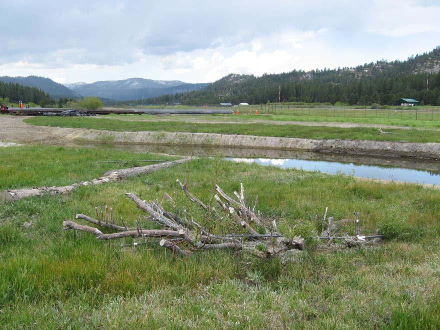
17 Adaptive Management Vegetation No additional planting was needed Erosion Small erosion repairs in 2004 Hand crews, jute netting and coir logs Minimal costs Permits were still active 12 years after LWS began functioning, the rest of river and marsh restoration has yet to be approved Post-Construction
18 Middle Reach Project Lower West Side
19 Middle Reach Project
")
20 NORTH Project Site Upper Truckee River, 1940 (~50 years after Comstock Logging)


21 Project Site River relocated for airport construction in 1958.


22 Project Site Static rip-rapped trapezoidal channel for ~50 years (2007)

23 Key Objectives Improve natural geomorphic function Increase overbank flow frequency and area Deposit sediment into the floodplain more frequently Avoid impacts to buried infrastructure and adjacent airport
 1 ENTRIX 2006 - Meaured DS of Elk's Club ENTRIX 2003 - Measured at USGS #10336610 0.")
 hiding function bed-material load at Sunset RS 25+670 USGS #10336610 Suspended Load (since 1989) 0.")
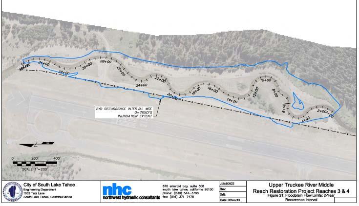
24 Design Elements Channel Analysis and Modeling HECRAS 6 miles of stream BSTEM to analyze options Bed load modeled and measured Effective discharge calculated under differing sediment load conditions Sensitivity analysis on channel geometry Design to overbank at 450 cfs Qs (tons/day) 1 ENTRIX Meaured DS of Elk's Club ENTRIX Measured at USGS # ENTRIX Measured at USGS # Sw anson Measured at USGS # Wilcock (2001) tw o-fraction calibrated bedload at Sunset RS Ackers & White (1973) w ith Proffitt & Sutherland's (1983) hiding function bed-material load at Sunset RS USGS # Suspended Load (since 1989) Post-Construction Q (ft 3 /s)


25 Implementation Highlights Reconstructed 2300 feet of Channel Installed 3 LWD habitat structures Removed 2 fish migration barriers Reconnected 18 acres of floodplain Construction Project Phasing Water quality protection Post-Construction

26 Project Site Channel reconstruction and floodplain reconnection, 2008

27 Project Site Post Construction Jan. 2011

28 Project Site Activated new channel and backfilled straight reach

29 Post Construction Nov. 2011


30 Monitoring Multiple Purpose Performance Effectiveness Multiple Parties, Multiple Approaches UTRWAG Qualitative observations and opinions Third Party Contractor Detailed Scope, > 5-year Plan Quantitative Construction


31 Too BIG? Just Right? Overbanking at 590 cfs

32


33 Adaptive Management Permit Restrictions Planning permit still open Water Board construction permit had expired No in-channel work, only hand work Erosion Repairs Launchable stone behind bank failure Cobble Toe with willow staking City Maintenance Crews completed the work Construction Post-Construction

34 Conclusions Thinking BIG is vulnerable to changes in players, priorities, funding and supporting science Moving forward on functionally independent elements generates confidence Monitoring remains difficult to fund and use for decision-making, even after decades of collaboration
35 Project Owners/Sponsors California Tahoe Conservancy City of South Lake Tahoe U.S. Bureau of Reclamation
FREQUENTLY ASKED QUESTIONS: URBAN STREAM RESTORATION BMP. David Wood Chesapeake Stormwater Network. Lisa Fraley-McNeal Center for Watershed Protection
 FREQUENTLY ASKED QUESTIONS: David Wood Chesapeake Stormwater Network URBAN STREAM RESTORATION BMP Lisa Fraley-McNeal Center for Watershed Protection Bill Stack Center for Watershed Protection FREQUENTLY
Economics of Implementing Two-stage Channels
 2011 A Partnership of USDA NIFA & Land Grant Colleges and Universities Economics of Implementing Two-stage Channels GREAT LAKES REGION Jon Witter, Jessica D Ambrosio, Joe Magner, Andy Ward and Bruce Wilson
Hydrologic and Ecologic Impacts from the CERP Indian River Lagoon South Project
 Hydrologic and Ecologic Impacts from the CERP Indian River Lagoon South Project Dr. Gretchen Ehlinger Senior Biologist US Army Corps of Engineers Jacksonville District November 15, 2016 AWRA Conference
SW-74 SERENOVA PRESERVE SITES 2, 3, 4, 8 MITIGATION PLAN
 SW-74 SERENOVA PRESERVE SITES 2, 3, 4, 8 MITIGATION PLAN BACKGROUND INFORMATION Project SWIM? Aquatic Control? Exotic Control? Mitigation Bank? Type No No No No Mitigation Restoration and enhancement Type
STREAM RESTORATION PURPOSE, PRACTICE, AND METHODS. By Marcus Rubenstein, CPESC
 STREAM RESTORATION PURPOSE, PRACTICE, AND METHODS By Marcus Rubenstein, CPESC WHAT IS STREAM RESTORATION? The return of a stream s lost natural functions, usually resulting from watershed alterations,
Municipal Stormwater Management Planning
 Municipal Stormwater Management Planning Christopher C. Obropta, Ph.D., P.E. Water Resources Extension Specialist with Rutgers Cooperative Extension Assistant Professor with Department of Environmental
Department of the Army Permit Application
 Department of the Army Permit Application DA File Number U.S. Army Corps of Engineers Honolulu District Date Received by CEPOH-RO Send Completed Application to: Honolulu District, U.S. Army Corps of Engineers
CHAPTER 7. San Dieguito River Flooding Adaptation
 CHAPTER 7 San Dieguito River Flooding Adaptation This chapter includes a range of adaptation measures to address vulnerabilities from flooding along the San Dieguito River, including the river valley,
STATE OF MINNESOTA MINNESOTA POLLUTION CONTROL AGENCY
 STATE OF MINNESOTA MINNESOTA POLLUTION CONTROL AGENCY In the Matter of the Decision on the Need for an Environmental Impact Statement for the Proposed Remer Wastewater Treatment Facility Expansion FINDINGS
Environmentally friendly drainage measures The use of two-stage profiles to improve diversity and water quality in agricultural streams
 Environmentally friendly drainage measures The use of two-stage profiles to improve diversity and water quality in agricultural streams European River Restoration Conference 2014, Vienna 27.-29.10.2014,
Project Goals and Scoping
 Prepared for: Boulder County, Colorado Flood Planning & Preliminary Design Services for South St. Vrain Creek Restoration at Hall Ranch and Scoping May 24, 2016 Meeting with General Public In association
THE BENEFITS OF MECHANICAL DEWATERING: CASE STUDY OF MACHADO LAKE ECOSYSTEM REHABILTATION PROJECT IN LOS ANGELES, CALIFORNIA
 THE BENEFITS OF MECHANICAL DEWATERING: CASE STUDY OF MACHADO LAKE ECOSYSTEM REHABILTATION PROJECT IN LOS ANGELES, CALIFORNIA Presented by: Thomas B. Amaro, VP/GM, Tim Azevedo, Chief Estimator Machado Lake
COON CREEK WATERSHED DISTRICT PERMIT REVIEW. Spring Lake Park Schools Westwood Middle School st Avenue NE, Spring Lake Park, MN 55432
 PAN 16-112, Westwood Middle School, Page 1 of 6 COON CREEK WATERSHED DISTRICT PERMIT REVIEW MEETING DATE: August 22, 2016 AGENDA NUMBER: 10 FILE NUMBER: 16-112 ITEM: Westwood Middle School RECOMMENDATION:
Chapter 10 Natural Environment
 Chapter 10 Natural Environment Existing Conditions The Natural Environment Element addresses the protection, conservation, preservation, and restoration of the natural resources the Bayview Ridge Subarea,
Appendix D - Evaluation of Interim Solutions
 Appendix D - Evaluation of Interim Solutions D.1 Introduction The implementation of long-term improvements is projected to take 5 to 8 years. To reduce the number of years of flooding impacts, the partner
Applying landforming to reclamation: A case study in Central Appalachia
 Applying landforming to reclamation: A case study in Central Appalachia Leslie Hopkinson, John Quaranta April 12, 2017 Department of Civil and Environmental Engineering West Virginia University WEST VIRGINIA
South St. Vrain / Hall Meadows Restoration Planning August 20, 2015
 South St. Vrain / Hall Meadows Restoration Planning August 20, 2015 Agenda Introductions Purpose & Goals of Meeting Planning Area Master Plan Restoration Planning: Cost Estimates, Grants, Scope, Timeline
Public Notice ISSUED: June 29, 2017 EXPIRES: July 31, 2017
 SPONSOR: Gary Pestorious Public Notice ISSUED: June 29, 2017 EXPIRES: July 31, 2017 REFER TO: 2012-01634-DAS SECTION:404 - Clean Water Act 1. WETLAND COMPENSATORY MITIGATION BANK PROPOSAL: Pickerel Lake
Holly Swartz and Jason Shirey
 Chapter 105 General Permits for Stream and Wetland Impacts DEP Ch. 105 CONTACTS FOR BERKS COUNTY: Holly Swartz and Jason Shirey What DEP Regulates Under Chapter 105 Waters of the Commonwealth, which includes
VILLAGE OF BELLAIRE WATER QUALITY ACTION PLAN
 VILLAGE OF BELLAIRE WATER QUALITY ACTION PLAN Elk-River-Chain-of-Lakes Gaps Analysis Project The Watershed Center Grand Traverse Bay Tip of the Mitt Watershed Council Michigan Department of Natural Resources
NOTICE OF PREPARATION
 NOTICE OF PREPARATION Date: June 12, 2014 To: From: Subject: Governor s Office of Planning and Research/State Clearinghouse Unit, Responsible Agencies, Trustee Agencies, and Interested Parties Announcement
Small Project Proposal
 Combined Scoping and Notice and Comment Document Small Project Proposal USDA Forest Service Fishlake National Forest Beaver Ranger District Sevier County, Utah The purpose of this document is to inform
Environmental Information Worksheet
 Environmental Information Worksheet Water System Owner (Attach additional sheets if necessary) Needs and Alternatives Provide a brief narrative that describes: Current drinking water system needs. Project
New Practices for Nutrient Reduction: STRIPs and Saturated Buffers. Matthew Helmers and Tom Isenhart Iowa State University
 New Practices for Nutrient Reduction: STRIPs and Saturated Buffers Matthew Helmers and Tom Isenhart Iowa State University Situation Increasing concern for local and regional waters Substantial demand for
Great Lakes Perspective Sediment Choreography
 Global Reach. Local Benefit. Great Lakes Perspective Sediment Choreography Jim White Director, Sustainable Infrastructure Program AAPA H&N 15 SEPTEMBER 2015 The Port is a partner in community development
In re: Town of Norwich Pool Dam Reconstruction, Stream Alteration Permit Application
 Agency of Natural Resources October 20, 2015 Neil R. Fulton Town Manager Town of Norwich P.O. Box 376 Norwich, VT 05055 In re: Town of Norwich Pool Dam Reconstruction, Stream Alteration Permit Application
Information for File # PRH
 Information for File # 2016-02602-PRH Applicant Corps Contact Tom Morley Paul Hauser Address 152 Baker Drive, Redwood Falls, MN 56283 E-Mail Paul.R.Hauser@usace.army.mil Phone 651-290-5357 Primary County
PUBLIC NOTICE. REPLY TO: Denver Regulatory Office 9307 South Wadsworth Blvd 30 DAY NOTICE Littleton, CO FAX (303)
") PUBLIC NOTICE US Army Corps of Engineers Omaha District Application No: NWO-2017-01366-DEN Project: Douglas Lane Tributary Stabilization Project Applicant: Town of Castle Rock Waterway: Douglas Lane Tributary
PUBLIC NOTICE US Army Corps of Engineers Omaha District Application No: NWO-2017-01366-DEN Project: Douglas Lane Tributary Stabilization Project Applicant: Town of Castle Rock Waterway: Douglas Lane Tributary
U.S. Army Corps of Engineers Mobile District
 U.S. Army Corps of Engineers Mobile District General Permit for Living Shorelines in Alabama Sandy P. Gibson Regulatory Specialist, Coastal Alabama Regulatory Division, Mobile District US Army Corps of
E. STORMWATER MANAGEMENT
 E. STORMWATER MANAGEMENT 1. Existing Conditions The Project Site is located within the Lower Hudson Watershed. According to the New York State Department of Environmental Conservation (NYSDEC), Lower Hudson
U.S. ARMY CORPS OF ENGINEERS. Little Rock District
 U.S. ARMY CORPS OF ENGINEERS Little Rock District SEDIMENT AND EROSION CONTROL GUIDELINES FOR PIPELINE PROJECTS Table of Contents 1.0 INTRODUCTION... - 1-2.0 PROJECTS IN WATERS OF THE UNITED STATES...
City of Phoenix Tres Rios Wetlands: Water Sustainability & Efficiency. Cynthia Campbell Water Resource Management Advisor City of Phoenix
 City of Phoenix Tres Rios Wetlands: Water Sustainability & Efficiency Cynthia Campbell Water Resource Management Advisor City of Phoenix Phoenix is a Desert City Phoenix Water Supplies 50% Salt/Verde Rivers
Applying Ecosystem Services to Collaborative Forest Management Elk River Public Meeting
 Applying Ecosystem Services to Collaborative Forest Management Elk River Public Meeting Nikola Smith Ecologist and Ecosystem Services Specialist U.S. Forest Service Port Orford City Hall February 2, 2017
FY16 RSM IPR Portland District, Optimizing Fall Creek Reservoir Flush TMDL s, Stanford Gibson, Chris Nygaard, Jim Crain, Jarod Norton
 Fall Creek Reservoir Fall Creek Dam is at river mile 7.2 on Fall Creek, a tributary of the Willamette River, about 20 miles southeast of Eugene, OR. Dam works in coordination with Lookout Point and Hills
Instream Flow Study for the Proposed Lower Bois d Arc Creek Reservoir, Texas
 450,000 400,000 350,000 300,000 250,000 200,000 150,000 Instream Flow Study for the Proposed Lower Bois d Arc Creek Reservoir, Texas 100,000 50,000 0 Jan-48 Jan-51 Jan-54 Jan-57 Jan-60 Jan-63 Jan-66 Jan-69
SURFACE WATER HYDROLOGY AND HYDRAULICS SECTION
 SURFACE WATER HYDROLOGY AND HYDRAULICS SECTION The mission of the Surface Water Hydrology and Hydraulics section is to generate historical and spatial scientific data, investigate and understand watershed
Riverbank Stabilization Techniques Workshop Merrimack River, Haverhill, MA
 Riverbank Stabilization Techniques Workshop Merrimack River, Haverhill, MA Dwight R. Dunk, PWS Association of Massachusetts Wetland Scientists September 30, 2011 Introduction Project History Design Development
Geomorphologic Condition and Shallow Aquifers
 Geomorphologic Condition and Shallow Aquifers Shann Stringer Center for Ecological Sciences Geomorphology Fluvial geomorphology is the study of the physics of water, sediment, riparian area, and floodplain
Notice of Availability of the Final Environmental Impact Statement for the Monument
 This document is scheduled to be published in the Federal Register on 06/24/2016 and available online at http://federalregister.gov/a/2016-15023, and on FDsys.gov 4310-DQ-P DEPARTMENT OF THE INTERIOR Bureau
Chapter 4 Watershed Goals and Objectives
 Chapter 4 Watershed Goals and Objectives Eight (8) long-term watershed goals have been developed by the NEW Watershed Advisory Group (WAG) after consideration of discussions held during monthly watershed
Riparian Buffers and Stream Restoration
 Riparian Buffers and Stream Restoration Why focus on riparian areas? Link land and water on any given site and link landscapes together in a watershed Riparian corridors protect the circulatory system
Fort Leonard Wood, Missouri. September 2013
 Fort Leonard Wood, Missouri September 2013 1 Presenters Shannon Kelly, Physical Scientist Clean Water Act Program Manager Directorate of Public Works Environmental Division Environmental Compliance Branch
1. Use Conceptual Ecosystem Models. Leigh Skaggs, Office of Water Project Review
 Recent Experiences with Cost Effectiveness and Incremental Cost Analyses (CE/ICA) for Ecosystem Restoration Projects Leigh Skaggs, Office of Water Project Review Recent reviews of Civil Works ecosystem
DEPARTMENT OF ENVIRONMENTAL PROTECTION Bureau of Water Quality Protection. Design Criteria - Wetlands Replacement/Monitoring
 DEPARTMENT OF ENVIRONMENTAL PROTECTION Bureau of Water Quality Protection DOCUMENT NUMBER: 363-0300-001 TITLE: Design Criteria - Wetlands Replacement/Monitoring EFFECTIVE DATE: February 11, 1997 AUTHORITY:
DRAFT TECHNICAL SPECIFICATIONS FOR
 DRAFT TECHNICAL SPECIFICATIONS FOR DETROIT RIVER AOC STONY ISLAND HABITAT RESTORATION PROJECT THE DETROIT RIVER, WAYNE COUNTY, MICHIGAN FOR INFORMATION JANUARY, 2016 Prepared for: FRIENDS OF THE DETROIT
Instructions for the South Pacific Division Nationwide Permit Pre- Construction Notification (PCN):
:") This PCN integrates the requirements of the U.S. Army Corps of Engineers (Corps) Nationwide Permit Program within the South Pacific Division (SPD), including the Albuquerque, Los Angeles, San Francisco,
This PCN integrates the requirements of the U.S. Army Corps of Engineers (Corps) Nationwide Permit Program within the South Pacific Division (SPD), including the Albuquerque, Los Angeles, San Francisco,
Maryland s Living Shorelines Program. Bhaskaran Subramanian February 27, 2015
 Maryland s Living Shorelines Program Bhaskaran Subramanian February 27, 2015 1 Erosion & traditional approaches Living shorelines- what is it? Maryland s Living Shorelines program LS Law Products Funding-
City of Phoenix Tres Rios Wetlands: Water Sustainability & Efficiency. Cynthia Campbell Water Resource Management Advisor City of Phoenix
 City of Phoenix Tres Rios Wetlands: Water Sustainability & Efficiency Cynthia Campbell Water Resource Management Advisor City of Phoenix Phoenix is a Desert City Phoenix Water Supplies 50% Salt/Verde Rivers
VIDEO: Riparian Forest Buffers: The Link Between Land & Water
 VIDEO: Riparian Forest Buffers: The Link Between Land & Water Introduction to Riparian Buffers Adapted from: Riparian Forest Buffers: The Link Between Land & Water. Maryland Cooperative Extension. Wye
Seepage Losses for the Rio Grande Project (Franklin Canal Case Study)
") Seepage Losses for the Rio Grande Project (Franklin Canal Case Study) Zhuping Sheng, Ph.D., P.E. Yaqi Wanyan, M.S., EIT Luis S. Aristizabal Kadambari Reddy, M.S., EIT TAMU, Agricultural Research and Extension
Seepage Losses for the Rio Grande Project (Franklin Canal Case Study) Zhuping Sheng, Ph.D., P.E. Yaqi Wanyan, M.S., EIT Luis S. Aristizabal Kadambari Reddy, M.S., EIT TAMU, Agricultural Research and Extension
CHAPTER 3 Environmental Guidelines for WATERCOURSE CROSSINGS GOVERNMENT OF NEWFOUNDLAND AND LABRADOR DEPARTMENT OF ENVIRONMENT AND LABOUR
 GOVERNMENT OF NEWFOUNDLAND AND LABRADOR DEPARTMENT OF ENVIRONMENT AND LABOUR CHAPTER 3 Environmental Guidelines for WATERCOURSE CROSSINGS WATER RESOURCES MANAGEMENT DIVISION Water Investigations Section
WWTP Protection Memo INTRODUCTION AND PURPOSE MODEL DEVELOPMENT AND ALTERNATIVES. August 31, PROJECT: TO: FROM: Re:
 WWTP Protection Memo August 31, 2017 PROJECT: TO: FROM: Re: City of Montesano WWTP Protection Log Jacks Matt Kastberg, Parametrix, Inc. Keelan Jensen, Dan Eggers, Henry Hu, WEST Consultants, Inc. WWTP
Will be modified map from GIS 6/16 EOD
 Middle-Snake-Tamarac Rivers Watershed District Judicial Ditch #19 Watershed Regional Conservation Partnership Program (RCPP) Public Scoping Meeting September 26, 2016 Will be modified map from GIS 6/16
Interstate-Callahan Upper and Lower Rock Dumps RA Construction Project. East Fork Ninemile Creek, Idaho May 3, 2016
 Interstate-Callahan Upper and Lower Rock Dumps RA Construction Project East Fork Ninemile Creek, Idaho May 3, 2016 Tony Wesche, P.E. Pioneer Technical Services, Inc. and North Wind Group Presentation Topics
Nutrient Management in. A presentation to the West Metro Water Alliance
 Nutrient Management in Developing and Agricultural Areas A presentation to the West Metro Water Alliance Chris Meehan, P.E. May 25, 2011 Agenda Physical Improvements Planning Improvements How to get it
Stormwater Local Design Manual For Houston County, Georgia
 Stormwater Local Design Manual For Houston County, Georgia Adopted November 15, 2005 TABLE OF CONTENTS 1. FORWARD... 1 2. GENERAL LEVEL OF SERVICE STANDARDS... 2 2.1. DETENTION REQUIREMENTS... 2 2.1.1.
Constructed Wetland Pond T-8
 Constructed Wetland Pond T-8 Description A constructed wetlands pond is a shallow retention pond designed to permit the growth of wetland plants such as rushes, willows, and cattails. Constructed wetlands
I THOUGHT IT WAS JUST WET LAND: A GUIDE TO ENVIRONMENTAL PERMITTING FOR AIRPORTS ROAD SCHOOL 2018 SIMON DAVIES, SENIOR SCIENTIST MARCH 7, 2018
 I THOUGHT IT WAS JUST WET LAND: A GUIDE TO ENVIRONMENTAL PERMITTING FOR AIRPORTS ROAD SCHOOL 2018 SIMON DAVIES, SENIOR SCIENTIST MARCH 7, 2018 Definition Regulatory Definition - Those areas that are inundated
Survey of Bottom Substrate Composition and Fish Habitat Value at Nett Lake
 Survey of Bottom Substrate Composition and Fish Habitat Value at Nett Lake Prepared by: Frank G. Stone, U.S. Fish & Wildlife Service Ashland FRO May 2006 The objective of this project was to characterize
Cass County Soil Erosion & Sedimentation Control Program
 Cass County Soil Erosion & Sedimentation Control Program Both residents and visitors of Cass County enjoy the beauty of over 250 lakes and ponds, along with numerous streams, creeks, and wetlands that
CHAPTER 9 DISCUSSIONS, CONCLUSIONS, AND RECOMMENDATIONS
 CHAPTER 9 DISCUSSIONS, CONCLUSIONS, AND RECOMMENDATIONS This chapter summarizes the results of feasibility level investigations undertaken to identify solutions to the water and related land resource problems
DEPARTMENT OF THE ARMY Wilmington District, Corps of Engineers 69 Darlington Avenue Wilmington, North Carolina April 24, 2017
 DEPARTMENT OF THE ARMY Wilmington District, Corps of Engineers 69 Darlington Avenue Wilmington, North Carolina 28403-1343 April 24, 2017 Regional General Permit No. 2016-00163 (RGP 163) Name of Permittee:
Intermittent Stream Reclamation
 Reclamation About Mosaic Reclamation > In carrying out its mission to help the world grow the food it needs, Mosaic couples recovery of phosphate resources with respect of the phosphate-rich land that
MnDOT Flash Flood Vulnerability and Adaptation Assessment Pilot Project DISTRICT 1 SILVER CREEK CASE STUDY
 MnDOT Flash Flood Vulnerability and Adaptation Assessment Pilot Project DISTRICT 1 SILVER CREEK CASE STUDY NOVEMBER 2014 This document is part of a series of short reports based on the full Flash Flood
Florida Department of Environmental Protection. Bureau of Mining and Minerals Regulation. Regulation of Mines. Howard J. Hayes, Program Administrator
 Florida Department of Environmental Protection Bureau of Mining and Minerals Regulation Regulation of Mines Howard J. Hayes, Program Administrator April 2011 What is a mine? Nonphosphate mine: Subsections
Lake County Success. support through synergistic local partnerships that not only mitigate, but also produce
 Lake County Success Generating Environmental Gains With Geothermal Power By Mark Dellinger, Administrator, Lake County (CA) Sanitation District, and Eliot Allen, Principal, Criterion/Planners Engineers
Before we get to the E&SC
 Erosion and Sedimentation Control on Mine Sites Ashley Rodgers, PE Assistant Regional Engineer NC DENR DEMLR RRO Before we get to the E&SC There are major differences in the application and review process
MODEL Stormwater Local Design Manual. City of Centerville
 MODEL Stormwater Local Design Manual City of Centerville Adopted December 6, 2005 TABLE OF CONTENTS 1. FORWARD... 1 2. GENERAL LEVEL OF SERVICE STANDARDS... 1 2.1. DETENTION REQUIREMENTS... 1 2.1.1. Discharge
7 Mineral and Energy Resources
 7 Mineral and Energy Resources This chapter examines Humboldt County s mineral (including sand and gravel extraction) and energy (oil, gas, and geothermal) resources. Existing General Plan policies and
SECTION EROSION AND SEDIMENTATION CONTROLS
 SECTION 312500 EROSION AND SEDIMENTATION CONTROLS PART 1 - GENERAL 1.01 GENERAL PROVISIONS A. Attention is directed to the CONTRACT AND GENERAL CONDITIONS and all Sections within DIVISION 01 - GENERAL
MITIGATED NEGATIVE DECLARATION & MITIGATION MONITORING PROGRAM CITY OF CHICO PLANNING DIVISION
 MITIGATED NEGATIVE DECLARATION & MITIGATION MONITORING PROGRAM CITY OF CHICO PLANNING DIVISION Based upon the analysis and findings contained within the attached initial study, a mitigated negative declaration
Habitat Grant Projects Clinton River Watershed
 Habitat Grant Projects Clinton River Watershed L Y N N E S E Y M O U R E N V I R O N M E N T A L E N G I N E E R O F F I C E O F T H E M A C O M B C O U N T Y P U B L I C W O R K S C O M M I S S I O N
Design Features of Constructed Wetlands for Nonpoint Source Treatment. September 1995
 Design Features of Constructed Wetlands for Nonpoint Source Treatment September 1995 Brochure written by William W. Jones, School of Public and Environmental Affairs, Indiana University, Bloomington, Indiana.
RECORD OF DECISION I. INTRODUCTION
 RECORD OF DECISION As the District Commander for the Los Angeles District, I have reviewed the Final Environmental Impact Statement/Environmental Impact Report (EIS/EIR) for the Newhall Ranch Resource
National Environmental Standards for Plantation Forestry. Overview of the regulations
 National Environmental Standards for Plantation Forestry Overview of the regulations New national rules for plantation forestry Plantation forestry is New Zealand s third largest primary sector. It delivers
Sediment Management Alternatives Analysis
 Conservancy District April 19, 2017 Sediment Management Alternatives Analysis Report prepared for the Conservancy District -Unionville, IN Report By: KCI Technologies, Inc. 6983 Corporate Circle Indianapolis,
Med (3) Locator Information/GPS GPS shows 16 ft accuracy Lat: Impact Rating
 Locator Information/GPS GPS shows 16 ft accuracy Lat: Impact Rating") (FERC 1927) Erosion Control Plan Site Remediation/ Assessment Form Site # Med (3) LM2-25 Priority Ranking Locator Information/GPS GPS shows 16 ft accuracy Lat: Long: Impact Rating 5 Start Project Development:
(FERC 1927) Erosion Control Plan Site Remediation/ Assessment Form Site # Med (3) LM2-25 Priority Ranking Locator Information/GPS GPS shows 16 ft accuracy Lat: Long: Impact Rating 5 Start Project Development:
Introduction to Sediment Remediation. Presented to: Lower Passaic River Community Advisory Group July 14, 2011
 Introduction to Sediment Remediation Presented to: Lower Passaic River Community Advisory Group July 14, 2011 Overview Feasibility Considerations Conceptual Site Model Dredging / Capping Dredged Material
Town of Essex, Vermont January, 2017 Standard Specifications For Construction CHAPTER 3 EROSION AND SEDIMENT CONTROL
 CHAPTER 3 EROSION AND SEDIMENT CONTROL CHAPTER 3 EROSION AND SEDIMENT CONTROL Section 300 General Summary All projects constructed within the Town of Essex shall be constructed in strict accordance with
United States Department of the Interior
 United States Department of the Interior FISH AND WILDLIFE SERVICE Red Bluff Fish & Wildlife Office 10950 Tyler Road, Red Bluff, California 96080 (530) 527-3043, FAX (530) 529-0292 July 20, 2015 To: Guy
Temporary Watercourse Crossing: Culverts
 Temporary Watercourse Crossing: Culverts DRAINAGE CONTROL TECHNIQUE Low Gradient Velocity Control Short Term Steep Gradient Channel Lining Medium-Long Term Outlet Control Soil Treatment Permanent Symbol
Avista Dam Relicensing Factsheet Commenting on the Draft License Application
 Avista Dam Relicensing Factsheet Commenting on the Draft License Application Please Note: This is intended for informational purposes only and does not constitute legal advice. The life of every river
Nationwide Permit General Conditions
 Nationwide Permit General Conditions Note: To qualify for NWP authorization, the prospective permittee must comply with the following general conditions, as applicable, in addition to any regional or case-specific
SUBSURFACE INFILTRATION SYSTEM DESCRIPTION. Alternative Names: Sump, Drywell, Infiltration Trench, Infiltration Galleries, Leach Fields
 4.1-d SUBSURFACE INFILTRATION SYSTEM Alternative Names: Sump, Drywell, Infiltration Trench, Infiltration Galleries, Leach Fields BMP DESIGN APPROACH Pollutant Source Control Hydrologic Source Control Stormwater
Notice No Closing Date: May 12, 2017
 Public Notice U.S. Army Corps of Engineers Pittsburgh District In Reply Refer to Notice No. below US Army Corps of Engineers, Pittsburgh District 1000 Liberty Avenue Pittsburgh, PA 15222-4186 Application
Keefer Pasture Drift Fence Project. Challis-Yankee Fork Ranger District Salmon-Challis National Forest
 Keefer Pasture Drift Fence Project Challis-Yankee Fork Ranger District Salmon-Challis National Forest PROPOSED ACTION The Challis-Yankee Fork Ranger District proposes construction of approximately.11 miles
Council of Governments
 Metropolitan Washington Council of Governments Anne Arundel County Draft Phase II Watershed Implementation Plan January 18, 2011 Chesapeake Bay TMDL Pollutants of Concern Nitrogen Phosphorus Sediment 2
DRAFT GREATER MOOSES TOOTH TWO (GMT2) DEVELOPMENT PROJECT PERMITTEE RESPONSIBLE WETLANDS MITIGATION PLAN NATIONAL PETROLEUM RESERVE-ALASKA
 DEVELOPMENT PROJECT PERMITTEE RESPONSIBLE WETLANDS MITIGATION PLAN NATIONAL PETROLEUM RESERVE-ALASKA") DRAFT GREATER MOOSES TOOTH TWO (GMT2) DEVELOPMENT PROJECT PERMITTEE RESPONSIBLE WETLANDS MITIGATION PLAN NATIONAL PETROLEUM RESERVE-ALASKA Prepared for: ConocoPhillips Alaska, Inc. Anchorage, AK March
DRAFT GREATER MOOSES TOOTH TWO (GMT2) DEVELOPMENT PROJECT PERMITTEE RESPONSIBLE WETLANDS MITIGATION PLAN NATIONAL PETROLEUM RESERVE-ALASKA Prepared for: ConocoPhillips Alaska, Inc. Anchorage, AK March
Stream Watch Visual Survey Instructions
 Stream Watch Visual Survey Instructions The Stream Watch Visual Survey is based on assessment parameters from the EPA's Rapid Bioassessment Protocol Habitat Assessment, Georgia Adopt a Stream Visual Survey,
Freight Street Development Strategy
 Freight Street Development Strategy Appendix B: Naugatuck River Floodplain Analysis Freight Street Development Strategy DECEMBER 2017 Page B-1 1.0 NAUGATUCK RIVER FLOODPLAIN AT FREIGHT STREET 1.1 Watershed
SECTION 11: REGULATORY FLOODWAYS
 SECTION 11: REGULATORY FLOODWAYS Contents 11.1. The Floodway... 11-2 11.1.1. The floodway concept... 11-2 11.1.2. Floodway map... 11-2 11.1.3. Floodway permitting... 11-3 11.1.4. Changing the floodway...
Bijou Area Erosion Control Project
 Join the City of South Lake Tahoe for a Ribbon Cutting Ceremony for the Bijou Area Erosion Control Project Thursday, October 30th at 3:30pm Ceremony will be held at the cul-de-sac at the end of Bal Bijou
Blanche Park Reservoir Decision Notice and Finding of No Significant Impact
 Blanche Park Reservoir Decision Notice and Finding of No Significant Impact U.S. Forest Service Grand Mesa, Uncompahgre, and Gunnison National Forests Delta County, Colorado INTRODUCTION The Grand Mesa
Marysville Levee Commission
 Marysville Levee Commission Outline CVFPP Goals & Objectives Highlights of Draft Feather River RFMP Integration between Flood Protection, Agriculture and Wildlife and Floodplain Uses Proposed Projects
A. C-I ROAD RULES APPENDIX C: 14 CCR DEFINITIONS.
 CALIFORNIA BOARD OF FORESTRY AND FIRE PROTECTION 357 APPENDIX C: California Board of Forestry and Fire Protection 2013 Road Rules and Technical Addendum No. 5: Guidance on hydrologic disconnection, road
PUBLIC NOTICE. Dredging with ten-years maintenance, return flow to the waterway and upland placement. Georgica Cove, tributary of Georgica Pond
 PUBLIC NOTICE US Army Corps of Engineers New York District Jacob K. Javits Federal Building New York, N.Y. 10278-0090 ATIN: Regulatory Branch In replying refer to: Public Notice Number: NAN-2016-01054-EHA
C-111 Spreader Canal Project: A Unique Example of Public Involvement and Adaptive Management in Everglades Restoration
 C-111 Spreader Canal Project: A Unique Example of Public Involvement and Adaptive Management in Everglades Restoration INTERCOL 9 June 7, 2012 Kenneth G. Ammon, P.E. Senior Vice President Overview South
TORCH LAKE TOWNSHIP WATER QUALITY ACTION PLAN
 TORCH LAKE TOWNSHIP WATER QUALITY ACTION PLAN Elk-River-Chain-of-Lakes Gaps Analysis Project The Watershed Center Grand Traverse Bay Tip of the Mitt Watershed Council Michigan Department of Natural Resources
Public Notice ISSUED: August 11, 2015 EXPIRES: September 10, 2015
 APPLICANT: John Deer Horicon Works Public Notice ISSUED: August 11, 2015 EXPIRES: September 10, 2015 REFER TO: MVP-2015-02020-JVD SECTION: 404 - Clean Water Act 1. APPLICATION FOR PERMIT TO discharge fill