KAW CONNECTS EXECUTIVE SUMMARY
|
|
|
- Felix Sherman
- 6 years ago
- Views:
Transcription

1

2 Executive Summary Page E-1 Introduction KAW CONNECTS EXECUTIVE SUMMARY The Kansas Department of Transportation (KDOT) and the Kansas Turnpike Authority (KTA) have both recognized the need to plan for the future transportation demands in the region between Topeka and Kansas City. To develop this plan, the two agencies initiated a Major Corridor Study (MCS) to identify and evaluate a wide variety of transportation investment alternatives. The impetus for this joint study was twofold. First, both agencies are keenly aware of significant traffic increases in the study area and the need to provide their customers with adequate transportation facilities now and in the future. Second, any improvements made by one agency will have direct impacts on the other and need to be studied in a comprehensive manner. Study Area As shown below, the study encompassed an area of approximately 50 miles by 26 miles and included portions of six counties in northeast Kansas: Johnson, Wyandotte, Leavenworth, Douglas, Jefferson, and Shawnee. Many communities within the study area rely on the existing transportation system for commuting and for goods movement. Major activity centers in the study area include the City of Topeka, City of Lawrence, and the Kansas City metropolitan area. The study area also contains several sizeable recreational areas and special event venues, including Perry Lake, Clinton Lake, Heartland Park Raceway, Sandstone Amphitheater, and the University of Kansas. In addition, a NASCAR speedway is under construction in Wyandotte County, and a Land of Oz theme park is being proposed in Johnson County (on the former Sunflower Ammunition Plant site). Study Area
3 Executive Summary Page E-2 Study Process The purpose of the was to provide the Kansas Department of Transportation, the Kansas Turnpike Authority, and the citizens of Kansas with a transportation planning tool that addresses the future travel needs between Topeka and Kansas City. To meet the intended purpose of the study, seven study goals were established; these goals are listed at right. The study required several significant data-collection efforts. A corridor-wide origin-destination (O-D) study collected license-plate data from 170,000 vehicles at 26 locations throughout the study area. Construction of computerized environmental constraint maps involved encoding 36 layers of geographical data, each covering the 725,000-acre study area. A corridor-wide telephone survey sampled opinions of over 400 road users. The study team collaborated with representatives of six counties and at least 14 cities. Six open house -style public meetings were attended by nearly 1,300 people. Study Goals 1 Identify existing mobility issues. 2 Identify current travel patterns. 3 Project future travel demands. 4 Identify future mobility needs. 5 Generate meaningful public and agency involvement. 6 Identify social, environmental, and economic issues that may impact future improvements. 7 Identify & analyze transportation improvement alternatives. The MCS incorporated an evaluation process consisting of two distinct screening activities. An evaluation methodology was developed for both screenings that included public input, engineering, mobility and environmental criteria. The first screening occurred early in the study to eliminate alternatives that did not meet the goals and objectives developed by both public and agency input. The second screening occurred near the end of the project to select the alternatives that would best fit within a preferred strategy for the region. In both screenings, all criteria were given equal consideration in a graded evaluation. Four study committees (listed below) provided invaluable assistance to the study team both in the technical and policy areas. These committees met at specific milestones during the course of the study to evaluate the findings and provide direction to the study team. The public was presented numerous opportunities to participate via public meetings, presentations, a corridor-wide telephone survey, a web page, a hotline and many traveling displays. Committee Membership Purpose Steering KDOT, KTA, FHWA Guide study development Advisory Technical Public Involvement Workgroup Local elected officials, Agency/coalition representatives, Economic Development representatives, Chamber of Commerce representatives, Other interested individuals City/County/State/MPO Staff Public affairs representatives from KDOT, KTA, MARC, other local agencies Provide input; Evaluate information provided by Consultant; Report study progress to member agency/group Provide input; Evaluate information provided by Consultant; Report study progress to member agency Provide input and guidance to study team regarding public involvement Once the final screening was conducted, the remaining alternatives were refined and assessed focusing on general corridor locations and estimated costs.
 operated and maintained by KTA.")
4 Executive Summary Page E-3 Existing Conditions The existing highway system within the study area includes several facility types, ranging from urban interstate freeways to rural two-lane highways. The major east-west facility in the study area is I-70, which runs through Topeka, Lawrence, and Kansas City. In the study area, I-70 is a toll facility (Turnpike) operated and maintained by KTA. Other major east/west facilities include K- 10, US-24, US-40, K-32, and 45 th Street/Stull Rd. Major north/south routes in the study include US-75, US-59, K-4, and K-7. Public transportation within the study area is provided by several individual bus services. No commuter rail or light rail operations currently exist. Both KDOT and KTA have experienced steady traffic growth in the study area. KDOT s priority formula has identified needs on several highways, including portions of K-4, US-24, US-40 and US-59. K-10 has also experienced rapid traffic growth. At the same time, KTA has experienced traffic increases on I-70 that are exceeding projections and could result in some segments operating at unacceptable levels of service within the next five years. In addition to congestion, several other traffic-related issues are also of concern to the general public, including safety, Turnpike access, Kansas River crossings, and the potential effects of new or improved highways. The map below highlights current areas of congestion within the study area. Congestion was measured using the Level of Service (LOS) concept based on daily traffic volumes, speeds and roadway characteristics; facilities operating at LOS D or worse were considered congested. Existing Areas of Congestion

5 Executive Summary Page E-4 Future (Year 2025) Conditions The study team developed a computerized transportation demand model to forecast Year 2025 conditions within the study area. The map below illustrates projected congestion in 2025 for the Existing plus Committed scenario, in which only currently programmed and funded highway improvements were assumed to be constructed. As the map shows, congestion is forecasted for the majority of the major east-west highways in the study area; in fact, 49 percent of the total study-area lane miles are anticipated to operate at LOS D or worse by Year 2025 Areas of Congestion The traffic model was used to evaluate the alternatives described in the following pages. Over 40 roadway network configurations were tested, each representing a unique combination of potential improvements. The effects of individual alternatives, as well as summary measures for key packages of alternatives, were evaluated and compared against each other. One significant data-gathering component of the traffic modeling, and a general tool for understanding traffic patterns in the study area, was the license-plate Origin-Destination (O-D) study conducted early in the process. Based on observations of over 170,000 vehicles traveling through the study area on a single day, the study team was able to generate key inputs to the traffic model related to the proportion of through trips. One of the findings of the O-D study was that the City of Lawrence was a primary origin and destination for trips to and from either end of the study area.
6 Executive Summary Page E-5 Initial Screening of Alternatives The study team initially developed 12 broad categories of improvements, ranging from multi-modal enhancements to Intelligent Transportation System (ITS) strategies. Through an initial screening process involving the input of key study committees and the general public, the list of categories was narrowed and refined. The initial screening process involved rating each strategy s ability to satisfy the five evaluation criteria listed at right. Below are listed the 12 initial strategies (plus the No Build option) and the results of the initial screening. Highway-related alternatives and the No Build option were retained for further analysis. Initial Screening Criteria 1 Meet traffic demands of the region 2 Minimize engineering/ construction impacts 3 Minimize negative environmental effects 4 Minimize negative economic/ social impacts 5 Maximize cost-effectiveness The phrase dropped as stand-alone indicates that the four strategies so named were not considered strong enough to meet the study goals by themselves. The study team decided that these alternatives would be most effective in combination with other, stronger alternatives. Results of the Initial Screening Carried Forward Strategies Strategies Dropped as Stand-alone Dropped Strategies No Build Transportation Systems Management (TSM) 1 Non-Motorized New Local Roadways Transportation Demand Management (TDM) 2 Commuter Rail Widen Existing Highways Intelligent Transportation Systems (ITS) 3 Light Rail New Interchanges Transit (Bus) New Toll-Supported Highways New Tax-Supported Highways Notes: 1 Transportation Systems Management (TSM) strategies include relatively low-cost enhancements to the existing transportation network that can greatly improve operational efficiency. Examples include traffic signal improvements, geometric improvements, and pavement-marking improvements. 2 Transportation Demand Management (TDM) strategies are aimed at reducing the volume (demand) of vehicles on the transportation network during peak periods. Examples include High-Occupancy-Vehicle (HOV) lanes, employee trip-reduction programs (such as telecommuting), parking management, and ridesharing. 3 Intelligent Transportation Systems (ITS) can be defined as the application of technology to the transportation system to increase efficiency and reduce motorists delays. Examples include automated incident detection/response, automated highways, and traveler information systems.
 formed the set of 26 alternatives that were to be analyzed in further detail. The table at right lists these alternatives.")
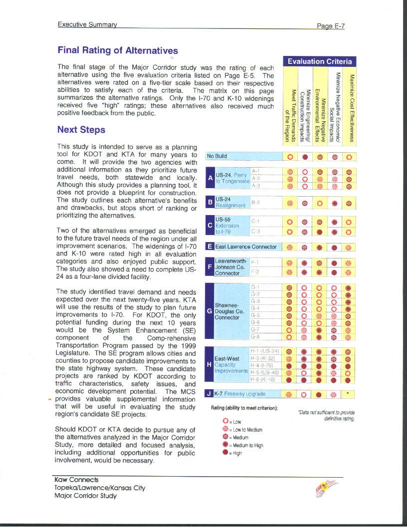
7 Executive Summary Page E-6 Final Screening of Alternatives Based on the Carried Forward strategies, the study team developed eight families of roadway improvements that (in addition to the No Build scenario) formed the set of 26 alternatives that were to be analyzed in further detail. The table at right lists these alternatives. Initially, these alternatives were loosely and conceptually defined based on public input; subsequently, they were refined to half-mile-wide corridors (based on feasible alignments) to allow a consistent basis for comparison. The map at the bottom of this page shows the approximate locations of these corridors. Each alternative was subjected to a detailed evaluation with respect to each of the five evaluation criteria listed on the previous page. The evaluation process integrated all of the information developed during study: traffic projections, environmental constraints, improvement cost estimates, inventories of existing topography and development, existing and expected growth and activity patterns, potential alignment locations, and public/ committee input. The evaluation process resulted in a final matrix, which is presented and described on the following page. A B C E F G H J Carried Forward Alternatives US-24 extension from Perry to Tonganoxie US-24 realignment US-59 extension from US-24 to I-70 East Lawrence bypass Leavenworth-Johnson County Connector Shawnee-Douglas County Connector East-West capacity improvements (widening existing roads) K-7 freeway upgrade Highway Corridor Alternatives
8
6.0 CONGESTION HOT SPOT PROBLEM AND IMPROVEMENT TRAVEL DEMAND MODEL ANALYSIS
 6.0 CONGESTION HOT SPOT PROBLEM AND IMPROVEMENT TRAVEL DEMAND MODEL ANALYSIS 6.1 MODEL RUN SUMMARY NOTEBOOK The Model Run Summary Notebook (under separate cover) provides documentation of the multiple
Kansas Department of Transportation s 5-County Regional Transportation Study Freight Movement Working Group Meeting
 Kansas Department of Transportation s 5-County Regional Transportation Study Freight Movement Working Group Meeting April 3, 2009 8:30-10:30 am Gardner City Hall- Council Chambers 120 E. Main St. Gardner,
35 Moving Forward. O p t i m i z a t i o n P l a n E x e c u t i v e S u m m a r y. Project # KA Johnson and Wyandotte Counties
 Moving Forward Johnson and Wyandotte Counties Project # -106-KA-2597-01 O p t i m i z a t i o n P l a n E x e c u t i v e S u m m a r y June 2013 I- Corridor Optimization Plan Executive Summary Study Purpose
Section 11: Transportation Strategies Toolbox
 Section 11: Transportation Strategies Toolbox A transportation strategies toolbox was developed to provide a systematic approach to identify potential strategies that address corridor transportation needs.
1RUWKZHVW#:LFKLWD 0DMRU#,QYHVWPHQW#6WXG\
 1RUWKZHVW#:LFKLWD 0DMRU#,QYHVWPHQW#6WXG\ Executive Summary 3UHSDUHGýIRUã 3UHSDUHGýE\ã.DQVDVý'HSDUWPHQWýRI 7UDQVSRUWDWLRQ,QýDVVRFLDWLRQýZLWKã (DUWKý7HFKý,QFï EXECUTIVE SUMMARY Introduction This Northwest
MARC Congestion Management Process Policy
 MARC Congestion Management Process Policy Adopted by the MARC Board of Directors on May 24, 2011 Background Traffic congestion can be generally defined as a condition where the volume of users on a transportation
Transportation Problems and Issues Excerpts from WWW Links
 Transportation Problems and Issues Excerpts from WWW Links Reference Bok, D. (2018). Transportation policy and planning. https://www.hks.harvard.edu/courses/transportation-policy-and-planning Transportation
7.0 TRANSPORTATION MANAGEMENT
 7.0 TRANSPORTATION MANAGEMENT I. Introduction/Current State of Transportation Management in KC Region The Kansas City region has invested considerable effort and resources in the design and implementation
Congestion Management Process (CMP)
") Congestion Management Process (CMP) Introduction The Congestion Management Process (CMP) is a systematic, data-driven, and regionally accepted approach that aims to improve the performance of the transportation
Congestion Management Process (CMP) Introduction The Congestion Management Process (CMP) is a systematic, data-driven, and regionally accepted approach that aims to improve the performance of the transportation
Final Congestion Management Process
 Final Congestion Management Process 2015 Prepared by Tulare County Association of Governments 210 N. Church St., Suite B Visalia, California 93291 1. Introduction: What Is Congestion? Congestion can generally
Congestion Management Process 2013 Update
 OVERVIEW OF THE DALLAS-FORT WORTH CONGESTION MANAGEMENT PROCESS Traffic Congestion In The Dallas-Fort Worth Region With the Dallas-Fort Worth (DFW) urban area as its center, the North Central Texas region
CHAPTER 2 - TRAVEL DEMAND MODEL DEVELOPMENT
 CHAPTER 2 - TRAVEL DEMAND MODEL DEVELOPMENT 2.1 EXISTING TRAVEL DEMAND MODEL In order to accurately project future year traffic volumes within this regional study area, it was first necessary to construct
4.0 STREETS & HIGHWAYS
 4.0 STREETS & HIGHWAYS I. Introduction The street and highway system constitutes the foundation of the region s overall transportation infrastructure, enabling the movement of people and goods. While the
Kansas Department of Transportation s 5-County Regional Transportation Study Stakeholder Advisory Panel Meeting
 Kansas Department of Transportation s 5-County Regional Transportation Study Stakeholder Advisory Panel Meeting May 5, 2009 8:30-10:30 a.m. Kansas Department of Transportation Olathe Office 1290 S. Enterprise
Blacklands Corridor Feasibility Study. Public Meeting March 20, 2014 Fletcher Warren Civic Center Greenville, TX
 Blacklands Corridor Feasibility Study Public Meeting March 20, 2014 Fletcher Warren Civic Center Greenville, TX 1 Overview Welcome, Overview, and Progress to Date Michael Morris Growth and Traffic Martin
8.0 Chapter 8 Alternatives Analysis
 8.0 Chapter 8 Alternatives Analysis The primary purpose for using CORSIM in the context of this manual is to guide the design process and program delivery. To this point in the manual, you have been given
Appendix L Greenhouse Gas 4-part Strategy
 Appendix L Greenhouse Gas 4-part Strategy Supplementary information regarding options for further reducing greenhouse gas emissions in the Puget Sound region State and Federal Greenhouse Gas Emissions
SECTION II CONTROLLED ACCESS FACILITIES
 SECTION II CONTROLLED ACCESS FACILITIES SYSTEM IDENTIFICATION A critical component of the Dallas-Fort Worth (DFW) Metropolitan Transportation System is the regional freeway and tollway systems, which are
Executive Summary. Study Background
 Executive Summary ES 1.1 Introduction The Capitol Region Council of Governments (CRCOG) and the Connecticut Department of Transportation (CTDOT) initiated the (BTS) in 2006 to identify near and long-term
PROJECT SUBMISSION FORM
 PROJECT SUBMISSION FORM Basic Project Information CEID 1182 1. Submitting Agency: MDOT/State Highway Administration 2. Secondary Agency: 3. Agency Project ID: 4. Project Type: Interstate Primary Secondary
ATTACHMENT A. Detailed Study Scope. I-66 (Inside) Multi-modal Study Scope
 Multi-modal Study Scope") ATTACHMENT A Detailed Study Scope I-66 (Inside) Multi-modal Study Scope EXECUTIVE SUMMARY The Virginia Department of Transportation (VDOT) seeks consultant assistance in identifying and evaluating a range
ATTACHMENT A Detailed Study Scope I-66 (Inside) Multi-modal Study Scope EXECUTIVE SUMMARY The Virginia Department of Transportation (VDOT) seeks consultant assistance in identifying and evaluating a range
10.0 Congestion Management Process
 Livability 2040 Regional Transportation Plan 10-1 10.0 Congestion Management Process 10.1 CMP Summary The identification and evaluation of projects for the Livability 2040 Regional Transportation Plan
Highway and Freight Current Investment Direction and Plan. TAB September 20, 2017
 Highway and Freight Current Investment Direction and Plan TAB September 20, 2017 Today s Topics Where are we now, what are the current issues? Where do we want to go? How will we get there? What are the
Technical Briefing Report
 Technical Briefing Report March 2007 CONGESTION MANAGEMENT PROCESS (CMP) The Congestion Management Process (CMP) seeks a management solution to a growing traffic problem by targeting resources to operational
Community Conversations for the I-35 Ramp Metering Project Begin This Month
 PRESS RELEASE FOR IMMEDIATE RELEASE September 18, 2015 For more information, contact: Michele Compton, KC Scout Senior Communications Specialist 816-607-2027 michele.compton@modot.mo.gov Community Conversations
MOBILITY 2025: THE METROPOLITAN TRANSPORTATION PLAN
 MOBILITY 2025: THE METROPOLITAN TRANSPORTATION PLAN Dan Lamers, P.E. North Central Texas Council of Governments Transportation Department www.nctcog.org/trans NORTH CENTRAL TEXAS COUNCIL OF GOVERNMENTS
IH 30/IH 35E Reconstruction Project Pegasus Final Technical Memorandum - Evaluation of Conceptual Alternatives Task 7.5
 MEMO TO: Timothy Nesbitt, P.E. DATE: August 26, 2002 FROM: SUBJECT: Sandy Wesch-Schulze, P.E., AICP IH 30/IH 35E Reconstruction Project Pegasus Final Technical Memorandum - Evaluation of Conceptual Alternatives
Chapter 5. Congestion Management Program. Chapter 5
 Chapter 5 Congestion Management Program Chapter 5 67 Chapter 5 Congestion Management Program Enacted in the early 1990s, California s Congestion Management Program (CMP) statutes encourage local jurisdictions
TRANSPORTATION RELATIONSHIP TO OTHER ELEMENTS OF THE PLAN AND COUNTY REGULATIONS VISION FOR TRANSPORTATION PLANNING ROAD NETWORK SECTION 7
 TRANSPORTATION Like many growing western counties, Douglas County focuses on one of the most integral elements in land-use planning: transportation. The primary purpose of a transportation network is to
North Central Texas Council of Governments. Workshop TxDOT Dallas
 Workshop TxDOT Dallas July 10, 2015 1 CMP Workshop Overview Overview of the CMP CMP and Documentation Project Implementation Form CMP Corridor Analysis Fact Sheet CMP Roadway Deficiency Form Project Examples
Chapter #9 TRAVEL DEMAND MODEL
 Chapter #9 TRAVEL DEMAND MODEL TABLE OF CONTENTS 9.0 Travel Demand Model...9-1 9.1 Introduction...9-1 9.2 Overview...9-1 9.2.1 Study Area...9-1 9.2.2 Travel Demand Modeling Process...9-3 9.3 The Memphis
THE PROJECT. Executive Summary. City of Industry. City of Diamond Bar. 57/60 Confluence.
 THE PROJECT A freeway segment ranked 6th worst in the Nation, with levels of congestion, pollution and accidents that are simply unacceptable and which have Statewide and National implications. Executive
Association for Commuter Transportation Recommendations to USDOT on MAP-21 Performance Measures
 Association for Commuter Transportation 1341 G Street, NW, 10th Floor Washington, DC 20005 Tel: 202.719.5331 www.actweb.org Association for Commuter Transportation Recommendations to USDOT on MAP-21 Performance
AMPO Annual Conference Session: Performance (Part 1) October 18, 2017 Savannah, GA
 October 18, 2017 Savannah, GA") AMPO Annual Conference Session: Performance (Part 1) October 18, 2017 Savannah, GA Introduction: North Jersey Transportation Planning Authority NJTPA Congestion Management Process Study Goals Analysis
AMPO Annual Conference Session: Performance (Part 1) October 18, 2017 Savannah, GA Introduction: North Jersey Transportation Planning Authority NJTPA Congestion Management Process Study Goals Analysis
FLORIDA DEPARTMENT OF TRANSPORTATION PROCEDURE DEVELOPMENT OF THE
 FLORIDA DEPARTMENT OF TRANSPORTATION PROCEDURE DEVELOPMENT OF THE FLORIDA INTRASTATE HIGHWAY SYSTEM Topic No.: 525-030-250-f Office: Systems Planning Effective Date: May 16, 2002 DEVELOPMENT OF THE FLORIDA
Proposed Comprehensive Update to the State of Rhode Island s Congestion Management Process
 Proposed Comprehensive Update to the State of Rhode Island s Statewide Planning Program January 2018 Summary Outline of of Action Steps 1. Develop Objectives for Congestion Management What is the desired
Current Trends in Traffic Congestion Mitigation
 Current Trends in Traffic Congestion Mitigation April 24, 2009 NCSL Spring Forum Washington, DC Jeff Lindley Associate Administrator, Office of Operations Federal Highway Administration U.S. Department
I-710 Project Committee Meeting
 Los Angeles County Metropolitan Transportation Authority I-710 Project Committee Meeting January 29, 2009 Meeting Expectations Review I-710 planning context Concur on a port cargo forecast scenario to
Summary of transportation-related goals and objectives from existing regional plans
 SMTC 2050 Long Range Transportation Plan Appendix A: Summary of transportation-related goals and objectives from existing regional plans SMTC 2050 Long Range Transportation Plan Summary of transportation-related
Appendix A: Project Planning and Development A-1 White Paper on Transit and the Tappan Zee Hudson River Crossing Project
 Appendix A: Project Planning and Development A-1 White Paper on Transit and the Tappan Zee Hudson River Crossing Project Purpose of White Paper White Paper on Transit and the Tappan Zee Hudson River Crossing
Chapter 10. Intelligent Transportation Systems. Ohio Kentucky Indiana Regional Council of Governments Regional Transportation Plan
 Chapter 10 Intelligent Transportation Systems Ohio Kentucky Indiana Regional Council of Governments 2030 Regional Transportation Plan Chapter 10 Intelligent Transportation Systems INTRODUCTION Intelligent
City of Berkeley. Guidelines for Development of Traffic Impact Reports
 Office of Transportation (OOT) City of Berkeley Guidelines for Development of Traffic Impact Reports Office of Transportation, City of Berkeley 1 1. Overview These guidelines provide a framework to help
Alternatives Identification and Evaluation
 I-290 Environmental Impact Statement West of Mannheim Road to East of Cicero Avenue Alternatives Identification and Evaluation May 2012 Draft Interim Report: Initial Alternatives Identification and Round
I-66 Corridor Improvements Outside the Capital Beltway in Northern Virginia, USA
 15th International Conference on Managed Lanes I-66 Corridor Improvements Outside the Capital Beltway in Northern Virginia, USA Case Study for Funding of Transit Service and Transportation Demand Management
MARTINSVILLE SOUTHERN CONNECTOR STUDY CITIZEN INFORMATION MEETING Magna Vista High School 701 Magna Vista School Road Ridgeway, Virginia May 8,
 MARTINSVILLE SOUTHERN CONNECTOR STUDY CITIZEN INFORMATION MEETING Magna Vista High School 701 Magna Vista School Road Ridgeway, Virginia 24148 May 8, 2018 MEETING OVERVIEW AND OBJECTIVES Introduce study
Highway and Freight Current Investment Direction and Plan. TAC August 2, 2017
 Highway and Freight Current Investment Direction and Plan TAC August 2, 2017 Today s Topics Highway & Freight Where are we now? The Highway Story What are the issues? How is the system performing? Where
GDOT-Office of Planning Update
 GDOT-Office of Planning Update GAMPO Conference Athens, Georgia Matthew Fowler, PTP Assistant Planning Administrator November 30, 2010 AGENDA Atlanta Region Managed Lane System Plan I-85 HOV to HOT Conversion
Charlotte Region HOV/HOT/Managed Lanes Analysis. Technical Memorandum Task 1.3 EVALUATION CRITERIA
 Charlotte Region HOV/HOT/Managed Lanes Analysis Technical Memorandum Task 1.3 EVALUATION CRITERIA October 23, 2007 TABLE OF CONTENTS 1.0 EVALUATION PROCESS -------------------------------------------------------------------------------------------
Operations in the 21st Century DOT Meeting Customers Needs and Expectations
 Operations in the 21st Century DOT Meeting Customers Needs and Expectations 1 Purpose of this Meeting: Share Thoughts & Discuss Challenges brought about by the changing transportation environment and public
3 INTERSTATES. The Carolina Crossroads Project Team Welcomes You
 The Carolina Crossroads Project Team Welcomes You 3 INTERSTATES + 12 = KEY INTERCHANGES We re here to: Discuss the Carolina Crossroads I-20/26/126 Corridor Project Gather your input on study issues We
Exhibit F: Comments from the MPO/RPO Meetings.
 Exhibit F: Comments from the MPO/RPO Meetings. Exhibit F: Comments from the MPO/RPO Meetings A summary of the specific feedback provided during the outreach effort with metropolitan and rural planning
Mobility 2025 Update: The Metropolitan Transportation Plan
 Mobility 2025 Update: The Metropolitan Transportation Plan May, 2001 North Central Texas Council of Governments Transportation Department MOBILITY 2025 UPDATE FINANCIAL SUMMARY Metropolitan Transportation
CONGESTION MANAGEMENT PROCESS (CMP) WEST MEMPHIS MPO
 WEST MEMPHIS MPO") CONGESTION MANAGEMENT PROCESS (CMP) WEST MEMPHIS MPO INTRODUCTION This policy document of the West Memphis Metropolitan Planning Organization (MPO) provides the framework to carryout the CMP in the West
CONGESTION MANAGEMENT PROCESS (CMP) WEST MEMPHIS MPO INTRODUCTION This policy document of the West Memphis Metropolitan Planning Organization (MPO) provides the framework to carryout the CMP in the West
Porter, D.R., Performance Standards for Growth Management. PAS Report 461. APA Planning Press: Chicago, IL. ed
 Porter, D.R., Performance Standards for Growth Management. PAS Report 461. APA Planning Press: Chicago, IL. ed. 1996. The first five chapters of this report discuss the various performance measures, including
MOBILITY AND ALTERNATIVES ANALYSIS
 6 MOBILITY AND ALTERNATIVES ANALYSIS BACK OF SECTION DIVIDER 6.0 Mobility and Alternatives Analysis Travel demand analysis provides a framework for the identification of transportation facilities and services
Database and Travel Demand Model
 Database and Travel Demand Model 7 The CMP legislation requires every CMA, in consultation with the regional transportation planning agency (the Metropolitan Transportation Commission (MTC) in the Bay
Workshop #3 Needs Assessment. Ministry of Transportation IBI Group March 27, 2014
 Workshop #3 Ministry of Transportation IBI Group Opening Remarks and Introductions page 1 Study Overview and Update page 2 History of the Study This study builds upon the 2002 MTO study Simcoe Area Transportation
Blacklands Corridor Feasibility Study
 Blacklands Corridor Feasibility Study Public Meeting May 13, 2014 The Atrium at the Granville Arts Center 300 N. Fifth Street, Garland, Texas 1 Overview Welcome and Public Involvement Efforts Amanda Wilson
CHAPTER 2. VISION, GOALS AND MTP FRAMEWORK
 CHAPTER 2. VISION, GOALS AND MTP FRAMEWORK MTP VISION In order to create a framework for the 2040 Metropolitan Transportation Plan (MTP), a vision statement was drafted by the Vision/Goals Committee and
APPENDIX D. Glossary D-1
 APPENDIX D Glossary D-1 Glossary of Transportation Planning Terms ANNUAL AVERAGE DAILY TRAFFIC (AADT): The total number of vehicles passing a given location on a roadway over the course of one year, divided
The Indian Nations Council of Governments (INCOG) 2035 Plan: Roadways Element
 2035 Plan: Roadways Element") Roadways The Indian Nations Council of Governments (INCOG) The Indian Nations Council of Governments is the designated regional planning organization for the Tulsa Transportation Management Area (TMA).
Roadways The Indian Nations Council of Governments (INCOG) The Indian Nations Council of Governments is the designated regional planning organization for the Tulsa Transportation Management Area (TMA).
Peninsula Widening. Project Description. Overview of Project Status. Estimated Total Project Cost $4.7 - $7.3 Billion
 Peninsula Widening SYSTEM: Interstate FROM: I-664 (Hampton Roads) TO: I-95 (Richmond) DESCRIPTION OF WORK: Provide for increased capacity, improve safety standards and minimize roadway geometric and structural
: value pricing. application of the 10 criteria for the long-term consideration of 5.1 THE UNIVERSE OF FACILITIES IN THE DALLAS- FORT WORTH REGION
 Re g i o n a l Va l u e P r i c i n g C o r r i d o r E v a l u at i o n a n d Fe a s i b i l i t y S t u d y N o r t h C e n t r a l T e x a s C o u n c i l o f G o v e r n m e n t s 5 application of
North I-75 Master Plan Summary
 North I-75 Master Plan Summary Florida Section ITE Annual Meeting November 3, 2017 The I-75 Relief Task Force Established by Secretary Boxold in October 2015 with broad membership Overarching goals Provide
Regional Transit Framework Study
 MARICOPA ASSOCIATION OF GOVERNMENTS Regional Transit Framework Study Regional Stakeholders Group Meeting #1 February 29, 2008 Copyright 2008 AGENDA Welcome and Introductions Project Process Regional Transit
Outer Loop/Rail Bypass Study
 Outer Loop/Rail Bypass Study Outer Loop Stakeholder Roundtable Southwest Segment Joshua City Hall April 16, 2008 North Central Texas Council of Governments Transportation Department Stakeholder Roundtable
Nashville Southeast Corridor High-Performance Transit Alternatives Study. Final Report
 Nashville Southeast Corridor High-Performance Transit Alternatives Study Final Report August 2007 - Nashville Southeast Corridor Executive Summary I. Introduction The southeast corridor is a 30 mile long
Bow Concord I-93 Improvements City of Concord Transportation Policy Advisory Committee
 Bow Concord I-93 Improvements City of Concord Transportation Policy Advisory Committee December 15, 2016 Agenda Project History / Project Development Process Traffic Modeling Alternatives Development o
Since the Vision 2000 effort under taken in 1995, ODOT has operated under a Mission,
 , and ODOT s Updated, and Since the Vision 2000 effort under taken in 1995, ODOT has operated under a, Vision, and. These were updated in 2000 and are updated again here by Senior Leadership to reflect
Alternatives Evaluation Report. Appendix C. Alternatives Evaluation Report
 s Evaluation Report Appendix C s Evaluation Report I-35W North Corridor Project EA Minnesota Department of Transportation Final Project s Report I-35W North Corridor Preliminary Design Project Report Version
Congestion Management Process Keeping the Region Moving Efficiently, Reliably, and Safely
 Congestion Management Process Keeping the Region Moving Efficiently, Reliably, and Safely Reviewed and Adopted By Tri-County Regional Planning Commission May 24, 2017 Prepared by the Tri-County Regional
FHWA Programs Supporting Freight
 FHWA Programs Supporting Freight Institute for Trade and Transportation Studies Conference Office of Operations 1200 New Jersey Avenue S.E. Washington, D.C. 20590 www.ops.fhwa.dot.gov/freight Jeff Purdy,
CHAPTER HIGHLIGHTS GOALS AND GUIDING POLICIES 60 SEEKING PUBLIC INPUT TO REFINE SCENARIOS FOR OUR FUTURE 61
 04 CHAPTER HIGHLIGHTS GOALS AND GUIDING POLICIES 60 SEEKING PUBLIC INPUT TO REFINE SCENARIOS FOR OUR FUTURE 61 SCENARIOS FOR THE FUTURE: IT S OUR CHOICE 63 CREATING A PLAN FOR OUR FUTURE The RTP/SCS is
Process to Identify High Priority Corridors for Access Management Near Large Urban Areas in Iowa Using Spatial Data
 Process to Identify High Priority Corridors for Access Management Near Large Urban Areas in Iowa Using Spatial Data David J. Plazak and Reginald R. Souleyrette Center for Transportation Research and Education
CLA /10.54, PID Project Description:
 Project Description: The proposed project will consist of widening IR 70 to three lanes from Enon Road (SLM 06.75) to the US 68 interchange ramps (SLM 10.55). IR 70 is a component of the Strategic Highway
I-270 NORTH EA PERFORMANCE MEASURES IN NEPA
 I-270 NORTH EA PERFORMANCE MEASURES IN NEPA Buddy Desai, PE CH2M St. Louis THE ISSUE US State Departments of Transportation continue to struggle with addressing current and emerging problems with increasingly
2035 LRTP Transportation Options Introduction
 2035 LRTP Transportation Options Introduction What is the 2035 LRTP? The 2035 Long-Range Transportation Plan (LRTP) is the guide for major transportation investments in the Durham-Chapel Hill-Carrboro
GUIDE FOR THE PREPARATION OF TRAFFIC IMPACT STUDIES
 GUIDE FOR THE PREPARATION OF TRAFFIC IMPACT STUDIES Adopted by Town Council on November 25, 2008 Prepared By: HNTB Engineering Department Planning Department TABLE OF CONTENTS I. INTRODUCTION... 1 II.
Appendix E Technical Description of the Modeling Framework
 Appendix E Technical Description of the Modeling Framework Appendix E Technical Description of Modeling Framework Appendix E Technical Description of Modeling Framework 1 In general terms, what analysis
PLAN 2040 Regional Transportation Plan Update. Final Recommendations. Transportation and Air Quality Committee March 13, 2014
 PLAN 2040 Regional Transportation Plan Update Final Recommendations Transportation and Air Quality Committee March 13, 2014 TIP/RTP Update Milestones Official public comment period closed February 21 Final
University of Virginia Master Planning Committee November 17 th Charlottesville Albemarle Metropolitan Planning Organization
 University of Virginia Master Planning Committee November 17 th 2010 Charlottesville Albemarle Metropolitan Planning Organization 1 Who are we? What is an MPO A Metropolitan Planning Organization is a
CHAPTER 8 TRANSPORTATION ELEMENT
 CHAPTER 8 TRANSPORTATION ELEMENT Section 8.01 Purpose: The purpose of this Chapter (element) is to establish the desired and projected transportation system within Niceville and to plan for future motorized
9.0 Meeting the Challenges
 9.0 Meeting the Challenges 9.1 SLRTP Goals The SLRTP is built around the six TxDOT Strategic Plan goals. 1. Develop an organizational structure and strategies designed to address the future multimodal
2 Purpose and Need. 2.1 Study Area. I-81 Corridor Improvement Study Tier 1 Draft Environmental Impact Statement
 2 Purpose and Need 2.1 Study Area Interstate 81 (I-81) is relied upon for local and regional travel and interstate travel in the eastern United States. It extends 855 miles from Tennessee to New York at
APPENDIX N East King County Subarea High Capacity Transit (HCT) Analysis: Approach to Assessing System-Level Alternatives
 Analysis: Approach to Assessing System-Level Alternatives") Sound Transit Regional Transit Long-Range Plan Draft Supplemental Environmental Impact Statement APPENDIX N East King County Subarea High Capacity Transit (HCT) Analysis: Approach to Assessing System-Level
Sound Transit Regional Transit Long-Range Plan Draft Supplemental Environmental Impact Statement APPENDIX N East King County Subarea High Capacity Transit (HCT) Analysis: Approach to Assessing System-Level
SCS Scenario Planning
 E SCS Scenario Planning Introduction As part of the 2035 MTP/SCS process, AMBAG developed a series of land use and transportation alternative scenarios for evaluation and testing to demonstrate how the
AIR QUALITY TECHNICAL MEMORANDUM
 AIR QUALITY TECHNICAL MEMORANDUM AIR QUALITY TECHNICAL MEMORANDUM GOLDEN GLADES INTERCHANGE PD&E STUDY Miami-Dade County, Florida Financial Management Number: 428358-1-22-01 Efficient Transportation Decision
Assessment of Current Status, Plans, and Preliminary Alternatives for High Capacity Transportation in the I-5 Corridor
 CONNECTING THURSTON COUNTY AND THE CENTRAL PUGET SOUND Alternatives to Meet Transportation Needs in the I-5 Corridor Working Paper #1 June 2011 Assessment of Current Status, Plans, and Preliminary Alternatives
NORTH I-75 MASTER PLAN Summary Report
 NORTH I-75 MASTER PLAN Summary Report Interstate 75 (SR 93) From the Florida s Turnpike Interchange to the I-10 Interchange Alachua, Bradford, Clay, Citrus, Columbia, Duval, Levy, Marion, and Sumter Counties,
CHAPTER 1: INTRODUCTION/ GOALS AND OBJECTIVES
 CHAPTER 1: INTRODUCTION/ GOALS AND OBJECTIVES 1.1: INTRODUCTION ABOUT THE FREDERICKSBURG AREA METROPOLITAN PLANNING ORGANIZATION (FAMPO) Established in 1992, the Fredericksburg Area Metropolitan Planning
WELCOME. Opportunity Corridor Committee Meeting #1. May 19, May 19, 2005
 WELCOME Opportunity Corridor Committee Meeting #1 1 2 University Circle Existing Access Study Area Interstate Highway System Rail Corridor 3 Project History Project Background/History Clark Freeway (1950
CHAPTER 5. City of Greensburg Comprehensive Plan. Introduction. Transportation Goals & Objectives
 CHAPTER 5 TRANSPORTATION Introduction The transportation system forms the backbone of the community. I-74 provides the community with connections to larger metropolitan areas such as Indianapolis and Cincinnati.
COFFEE WITH THE MAYOR. September 10, 2010
 COFFEE WITH THE MAYOR September 10, 2010 JBLM LOCATION TACOMA 163 road miles Part of Seattle-Tacoma-Olympia metropolitan region Bisected by Interstate 5 JBLM - 86, 176 Acres Yakima Training Center - 323,651
Congestion Management Process Update
 report Congestion Management Process Update prepared for Houston-Galveston Area Council prepared by Cambridge Systematics, Inc. 10415 Morado Circle, Building II, Suite 340 Austin, TX 78759 with Alliance
MONITORING IMPLEMENTATION AND PERFORMANCE
 12 MONITORING IMPLEMENTATION AND PERFORMANCE The FAST Act continues the legislation authorized under MAP-21, which created a data-driven, performance-based multimodal program to address the many challenges
Examining the Economic Trade-offs of Alternative Transportation Funding NC I-95 Economic Assessment
 Examining the Economic Trade-offs of Alternative Transportation Funding NC I-95 Economic Assessment presented to ITED Conference presented by Cambridge Systematics, Inc. Paula Dowell, PhD April 2014 Background
DRAFT Congestion Management Process Keeping the Region Moving Efficiently, Reliably, and Safely
 Congestion Management Process Keeping the Region Moving Efficiently, Reliably, and Safely February 28, 2017 Prepared by the Tri-County Regional Planning Commission 3135 Pine Tree, Suite 2C Lansing, Michigan
Highest Priority Performance Measures for the TPP
 Highest Priority Performance Measures for the TPP The following list of measures are the highest priority performance measures as identified by modal working groups. These groups consist of staff from
Lubbock Outer Route Feasibility Study Report Executive Summary
 Lubbock Outer Route Feasibility Study Report Executive Summary Prepared for: Texas Department of Transportation Lubbock District Prepared by: MACTEC Engineering and Consulting, Inc. 6701 Aberdeen, Suite
Transportation Improvement Program (TIP) Relationship to 2040 Metropolitan Transportation Plan (MTP) - Goals and Performance Measures
 Relationship to 2040 Metropolitan Transportation Plan (MTP) - Goals and Performance Measures") Mid-Region Metropolitan Planning Organization Mid-Region Council of Governments 809 Copper Avenue NW Albuquerque, New Mexico 87102 (505) 247-1750-tel. (505) 247-1753-fax www.mrcog-nm.gov Transportation
Mid-Region Metropolitan Planning Organization Mid-Region Council of Governments 809 Copper Avenue NW Albuquerque, New Mexico 87102 (505) 247-1750-tel. (505) 247-1753-fax www.mrcog-nm.gov Transportation