Surface Water Impacts from Groundwater Withdrawals. Presented by: Al Pratt Steve Howe
|
|
|
- Shannon Oswald McLaughlin
- 5 years ago
- Views:
Transcription

1 Surface Water Impacts from Groundwater Withdrawals Presented by: Al Pratt Steve Howe New Hampshire Water and Watershed Conference March 25, 2011
2 Why should we care? Groundwater withdrawals have the potential to: Reduce flow and water levels in surface waters and wetlands Impair uses (designated and existing) Impact aquatic habitat Impact natural hydrologic conditions Degrade functional values of wetlands Sustainable use of our resources is necessary to ensure the natural condition of our environment is maintained and the health of our ecosystem is protected.

3 Hydrogeology Aquifers in New Hampshire Stratified Drift Glacial Outwash Sand and Gravel High Well Yield Potential Near Surface Water Features Bedrock Storage in Fractures Typically Low Yield Potentially Distant Impacts

4 Stratified Drift Aquifers Potential Impact Area Zone of Influence Cone of Depression Zone of Contribution Recharge Area Downgradient Area Reference: Ground Water Protection Council, 2007; NH Water Resources Primer, 2008

5 Stratified Drift Aquifers Potential Impact Area Zone of Influence Cone of Depression Zone of Contribution Recharge Area Downgradient Area Reference: FAQ Regarding Large Groundwater Withdrawal Permitting in NH, NHDES 2008

6 Stratified Drift Aquifers
 Reducing surface water levels or flows that will, or do, cause a violation of surface water quality rules adopted by the")
7 Groundwater Protection Act (RSA 485-C) Excerpt from RSA 485-C:21 Approval for Large Groundwater Withdrawals, Section V-c: In order to preserve the public trust, no large groundwater withdrawal shall cause an unmitigated impact as determined by the following: (f) Reducing surface water levels or flows that will, or do, cause a violation of surface water quality rules adopted by the department

8 Groundwater Protection Act (RSA 485-C) Surface Water Quality Regulations (Env-Wq 1700) Env-Wq Water Use Classification All surface water shall be restored to meet the water quality criteria for their designated classification and to maintain the chemical, physical, and biological integrity of surface waters Unless the flows are caused by naturally occurring conditions, surface water quantity shall be maintained at levels adequate to protect existing and designated uses. Recreation Public Water Supplies Aquatic Life and Wildlife Fish / Shellfish Consumption Others proposed: Geomorphic Integrity Agriculture


9 Groundwater Protection Act (RSA 485-C) Surface Water Quality Regulations (Env-Wq 1700) Env-Wq Biological and Aquatic Community Integrity The surface waters shall support and maintain a balanced, integrated, and adaptive community of organisms having a species composition, diversity, and functional organization comparable to that of similar natural habitats of a region. Env-Wq 1708 Antidegradation Existing uses and the level of water quality necessary to protect uses shall be maintained and protected:
 Reducing surface water levels or flows that will, or do, cause a violation of surface water quality rules adopted by the department (g)")
10 Groundwater Protection Act (RSA 485-C) Excerpt from RSA 485-C:21 Approval for Large Groundwater Withdrawals, Section V-c: In order to preserve the public trust, no large groundwater withdrawal shall cause an unmitigated impact as determined by the following: (f) Reducing surface water levels or flows that will, or do, cause a violation of surface water quality rules adopted by the department (g) Causing a net loss of values for submerged lands under tidal and fresh waters and its wetlands as set forth in RSA 482-A
11 Groundwater Protection Act (RSA 485-C) Fill and Dredge in Wetlands (RSA 482-A:1) Values specified under Finding of Public Purpose Nutrients for finfish, crustacea, shellfish and wildlife of significant value, Habitats and reproduction areas for plants, fish and wildlife of importance, Commerce, recreation and aesthetic enjoyment of the public, Adequate groundwater levels (recharge storage), Stream channels and their ability to handle the runoff of waters (channel protection), Natural ability of wetlands to absorb flood waters and silt, thus increasing general flood damage and the silting of open water channels, Interests of the general public.
12 Groundwater Protection Act (RSA 485-C) Excerpt from RSA 485-C:21 Approval for Large Groundwater Withdrawals, Section V-c: In order to preserve the public trust, no large groundwater withdrawal shall cause an unmitigated impact as determined by the following: (f) Reducing surface water levels or flows that will, or do, cause a violation of surface water quality rules adopted by the department (g) Causing a net loss of values for submerged lands under tidal and fresh waters and its wetlands as set forth in RSA 482-A (i) Reducing river flows below acceptable levels established pursuant to RSA 483


13 Groundwater Protection Act (RSA 485-C) Rivers Management and Protection Program (RSA 483) Statement of Policy (RSA 483:1) Encourage and assist in the development of river corridor management plans and; Regulate the quantity and quality of instream flow along certain protected rivers or segments of rivers to conserve and protect outstanding characteristics including: Recreational, fisheries, wildlife, environmental, hydropower, cultural, historical, archaeological, scientific, ecological, aesthetic, community significance, agricultural, and public water supply
14 Large Groundwater Withdrawal Permit Sections in Env-Wq 403 pertaining to potential impacts to surface water and wetlands Conceptual Hydrologic Model Typical Data Sources: Maps (geologic, aquifer, soils, lineament, and topographic) Published reports Historical hydrogeologic data Site hydrogeologic investigations (test wells & borings, geophysics, etc ) Shall Include: Description of the geology and geomorphologic history Geologic cross-section through site Delineation of Potential Impact Area and its components Identification of data gaps
15 Large Groundwater Withdrawal Permit Sections in Env-Wq 403 pertaining to potential impacts to surface water and wetlands Hydrologic cycle description and water budget calculations Assess the distribution and availability of water necessary to maintain natural resources Inventory of water resources and uses Water-related natural resource in the Potential Impact Area Surface waters Wetlands Springs Vernal pools Any other water-related natural resources that might be influenced by the withdrawal Rare species and exemplary natural communities (NH DRED-NHB)

16 Large Groundwater Withdrawal Permit Sections in Env-Wq 403 pertaining to potential impacts to surface water and wetlands Impact Description (Final Permit Application Report) Impacts shall be quantified to the extent necessary to determine whether adverse impacts might occur, and, if adverse impacts might occur, to: Develop a monitoring and reporting program, Develop mitigation measures, Revise production volume of the withdrawal to ensure adverse impacts do not occur
17 Large Groundwater Withdrawal Permit Sections in Env-Wq 403 pertaining to potential impacts to surface water and wetlands Impact Monitoring and Reporting Program Wetlands Monitoring (Env-Wq ) Initial survey Functions of the wetland as part of the natural ecosystem Hydrology Soil types Soil moisture Stratigraphy Routine monitoring of wetland characteristics Shallow groundwater levels (piezometers and micro-wells)
18 Large Groundwater Withdrawal Permit Sections in Env-Wq 403 pertaining to potential impacts to surface water and wetlands Impact Monitoring and Reporting Program Surface Water Monitoring (Env-Wq ) Initial Survey Inventory and mapping of aquatic flora and fauna species and habitat Factors that control water level elevations, and Identification of anticipated seasonal fluctuations in temperature and nutrients Long-Term Monitoring Water levels Stream flow Instream or other submerged habitat to identify the health of aquatic ecosystems

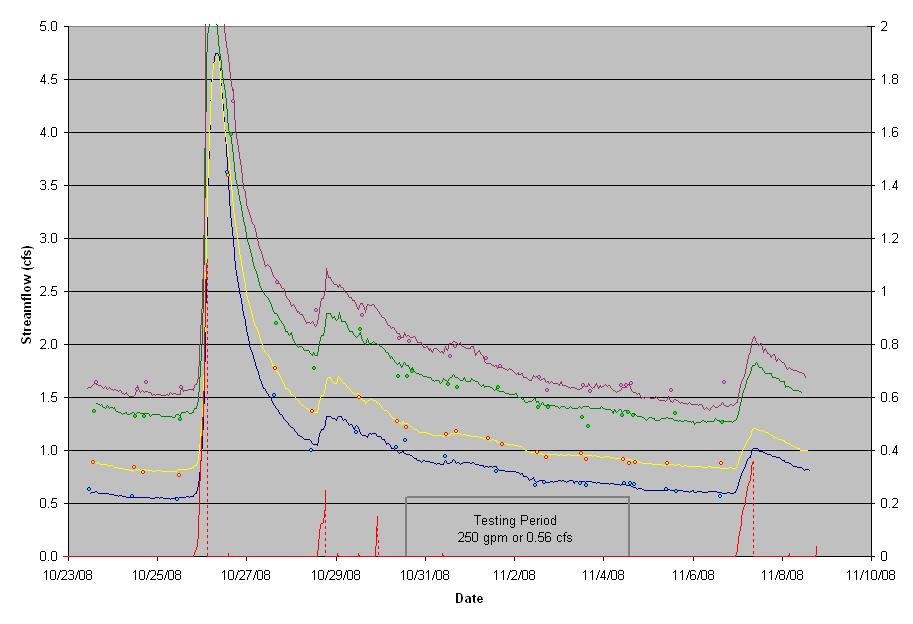
19 Surface Water Impact Assessment and Monitoring Short term impacts Pumping Test

20 Some systems are noisy by nature. Background monitoring can characterize existing fluctuations.
21 Understanding background changes helps understand pumping influence. Understanding habitat will help understand potential long-term impacts of withdrawals.

22 Surface water monitoring short term impacts and long term monitoring

23 Wetlands water levels and physical changes
24 Low-flow monitoring and requirements Instream flow or passby flow

25 Flumes variety of sizes and types


26

27

28 Check installation for proper design, calibrate if necessary

29 Maintenance is necessary

30 Weirs variety of sizes and types

31

32

33

34

35 Check installation for proper design modify or calibrate if necessary

36 Check installation for proper design modify or calibrate if necessary

37 Modify or calibrate if necessary

38 Weir insert for improved low-flow resolution


39 Direct methods of surface water measurement
40

41 Rating Curves shift through time


42 Wetland piezometers

43

44

45
46

47 Questions? Steve Howe Al Pratt, P.E
Streamlining New Hampshire's Wetlands Permitting-- An Ongoing Process. Sandy Crystall, PWS New Hampshire Dept of Environmental Services May 2008
 Streamlining New Hampshire's Wetlands Permitting-- An Ongoing Process Sandy Crystall, PWS New Hampshire Dept of Environmental Services May 2008 Introduction Background Historical streamlining changes Program
Prime Wetlands: Study, Designation and Thereafter. Sandy Crystall, PWS Wetlands Bureau Nov 2009
 Prime Wetlands: Study, Designation and Thereafter Sandy Crystall, PWS Wetlands Bureau Nov 2009 Introduction Wetlands and their protection in New Hampshire Why designate prime wetlands? Process and effect
DEVELOPMENT OF AQUIFER TESTING PLANS. Brent Bauman, P.G. / Erin Lynam, Aquatic Biologist
 DEVELOPMENT OF AQUIFER TESTING PLANS Brent Bauman, P.G. / Erin Lynam, Aquatic Biologist DEVELOPMENT OF AQUIFER TESTING PLANS Goals of Aquifer Testing What questions are we trying to answer Staff review
FREQUENTLY ASKED QUESTIONS
 WETLAND INVENTORY AND PRIME WETLAND DESIGNATION FREQUENTLY ASKED QUESTIONS 1. Why was a Wetland Inventory conducted? The Master Plan adopted by the Town in 2005 mandated that the Grantham Conservation
2013 Water and Watershed Conference Plymouth State University March 22, Chris Skoglund
 New Hampshire s Watersheds at a Crossroads Coordinating a Response to Climate Change, Population Growth and Land-Use Change Using the DPSIR Model 2013 Water and Watershed Conference Plymouth State University
Current Applicant s Handbook Wetland Criteria No Harm Standards. Narrative Standard All categories. Assessment
 District 40X-2.301 Exclusions SFWMD SJRWMD harm to s or waters; harmful 1) Isolated s ½ acre or less (some caveats) 2) Wetlands be impacts by an ERP or SWM; 3) constructed waterbodies 4) s & waters that
Town of Sandown Wetland Evaluation Report
 Town of Sandown Wetland Evaluation Report Prepared for: Town of Sandown, NH Conservation Commission August 2008 Prepared by: 122 Mast Road, Suite 6, Lee, NH 03861 with assistance from TABLE OF CONTENTS
GROUNDWATER DISCHARGE
 GROUNDWATER DISCHARGE C O N N E C T I O N F A C T S H E E T S E R I E S D I S C H A R G E : The movement of groundwater from the subsurface to the surface P E R M E A B I L I T Y : The ability of a material
RESPONSIBLE PLANNING FOR FUTURE GROUND WATER USE FROM THE GREAT FLATS AQUIFER : TWO CASE STUDIES: THE GEP ENERGY
 RESPONSIBLE PLANNING FOR FUTURE GROUND WATER USE FROM THE GREAT FLATS AQUIFER : TWO CASE STUDIES: THE GEP ENERGY Introduction PROJECT AND THE SI GREEN FUELS BOILER PROJECT Thomas M. Johnson Hydrogeologist,
ANCR INDIVIDUAL RESPONSES SUMMARY: 2/11/04 WATER RESOURCES GOALS AND OBJECTIVES
 ANCR INDIVIDUAL RESPONSES SUMMARY: 2/11/04 WATER RESOURCES GOALS AND OBJECTIVES Goal 1: Protect the health and safety of the Dane County population. a. Prevent development that may have an adverse effect
FLORIDA ATLANTIC UNIVERSITY
 Supporting Data The purpose of the Element is to ensure the conservation, protection, and wise use of all natural ecosystems and natural resources on the University campus and in the context area. 1. Inventory
Chapter 4 Watershed Goals and Objectives
 Chapter 4 Watershed Goals and Objectives Eight (8) long-term watershed goals have been developed by the NEW Watershed Advisory Group (WAG) after consideration of discussions held during monthly watershed
Report. Environmental Water Demands. Butte County Department of Water and Resource Conservation Integrated Water Resources Plan.
 Report Butte County Department of Water and Resource Conservation Integrated Water Resources Plan s June 2004 s Section 1 - Introduction 1.1 Project Description This project is a preliminary investigation
Unify efforts to address water resources for the Big Sky area and surrounding zone of influence in three co-equal water resources focus areas:
 EXECUTIVE SUMMARY The Big Sky Sustainable Water Solutions Forum (Water Forum) is a community-based, collaborative approach building a unified vision for future Big Sky water resources management to maintain
Phosphorus Goal Setting Process Questions and Answers 2010
 Lake Winnipesaukee Watershed Management Plan Phase I: Meredith, Paugus, Saunders Bays 1. What is phosphorus? Phosphorus (P) is a naturally occurring element and a major nutrient required for biological
Town of Fremont Wetland Evaluation Report
 University of New Hampshire University of New Hampshire Scholars' Repository PREP Reports & Publications Institute for the Study of Earth, Oceans, and Space (EOS) 9-2007 Town of Fremont Wetland Evaluation
City of Bishop. Environmental Checklist Form
 City of Bishop Environmental Checklist Form 1. Project title: Environmental Review / 2007 California Building Codes 2. Lead agency name and address: City of Bishop 377 W. Line Street Bishop, Ca 93514 3.
(1)(A)Inventory of the following existing natural resources on the USFSP Campus or within the context area adjacent to the University.
(A)Inventory of the following existing natural resources on the USFSP Campus or within the context area adjacent to the University.") 13. 6C-21.208 CONSERVATION ELEMENT Information Sources George F. Young, Interview notes, June 2002 Sasaki Associates, Inc., interview notes, April, 2000 Interviews between DRMP Staff and USF Staff, May,
13. 6C-21.208 CONSERVATION ELEMENT Information Sources George F. Young, Interview notes, June 2002 Sasaki Associates, Inc., interview notes, April, 2000 Interviews between DRMP Staff and USF Staff, May,
Environmental Resource Inventories. What are ERIs? Significance of information How to use them
 Environmental Resource Inventories What are ERIs? Significance of information How to use them Environmental Resource Inventory - ERI Compiled by the environmental commission Information about the natural
APPENDIX M CEQA Initial Study Checklist
 APPENDIX M CEQA Initial Study Checklist Appendix G ENVIRONMENTAL CHECKLIST FORM (To be Completed by Applicant) 1. Project title: 2. Lead agency name and address: 3. Contact person and phone number: 4.
PUBLIC REVIEW SESSION
 Carolina North Ecological Assessment PUBLIC REVIEW SESSION Carolina North Ecological Assessment Carolina North Ecological Assessment Carolina North Ecological Assessment http//cn.unc.edu Background Ecological
Carolina North Ecological Assessment. Carolina North Ecological Assessment PEER REVIEW
 Carolina North Ecological Assessment PEER REVIEW Carolina North Ecological Assessment Background Ecological Characterization and land development suitability analysis for the Carolina North property Goal
Hydrologic Regime; Past and Present and Water Quality Implications
 Hydrologic Regime; Past and Present and Water Quality Implications Waseca County Water Plan Meeting Waseca County Courthouse Annex November 16, 2016 Dan Girolamo, Area Hydrologist, Waterville, MN Topics
ORDINANCE # 854. Stormwater Management / Operation and Maintenance Requirements
 ORDINANCE # 854 Stormwater Management / Operation and Maintenance Requirements Section 1. Purpose and Authority In accordance with the provisions of Chapters 98, 124, 126, 440, 444, and 446h of the General
Planning for Future Water Supply Needs. Brandon Kernen NH Department of Environmental Services
 Planning for Future Water Supply Needs Brandon Kernen NH Department of Environmental Services Brandon.Kernen@des.nh.gov & 603 271-0660 Objectives 1)Legal Considerations 2)Methods to Assess Future Water
ENVIRONMENT ACT TERMS OF REFERENCE NOVA SCOTIA DEPARTMENT OF TRANSPORTATION AND PUBLIC WORKS. Beaver Bank Bypass
 ENVIRONMENT ACT TERMS OF REFERENCE NOVA SCOTIA DEPARTMENT OF TRANSPORTATION AND PUBLIC WORKS Beaver Bank Bypass Highway 101 to the Beaver Bank Road Halifax County, NS NOVA SCOTIA DEPARTMENT OF THE ENVIRONMENT
Water and Watersheds. Data Maps Action
 Water and Watersheds Data Maps Action What is the Wildlife Action Plan? Restore rare wildlife and habitats. Keep common species common. 2015 Revision: Partners in Conservation Science 2015 Revision Data
Mitigation Banking. Southeast Stormwater Association SESWA. Creative Alternatives for Stormwater Funding. April 23, 2010
 Mitigation Banking Southeast Stormwater Association SESWA Creative Alternatives for Stormwater Funding April 23, 2010 Steve Leo, Stormwater Management Director, Gwinnett County Pete Wright, Principal Engineer,
Understanding and Restoring Natural Floodplain Function. Gary James CTUIR Fisheries Program Manager
 Understanding and Restoring Natural Floodplain Function Gary James Fisheries Program Manager Future of Our Salmon Technical Workshop on Healthy Floodplains Spokane, WA - August 16-18, 2016 Presentation
Suffolk Downs Redevelopment. Appendix G: Stormwater Management Supporting Documentation
 Suffolk Downs Redevelopment Expanded PNF Appendix G: Stormwater Management Supporting Documentation Suffolk Downs Redevelopment Phase 1 Stormwater Management Report Boston, Massachusetts 285402RP004 TABLE
2008 REPORT OF THE ACTIVITY OF THE NEW HAMPSHIRE DEPARTMENT OF ENVIRONMENTAL SERVICES AQUATIC RESOURCE MITIGATION FUND PROGRAM.
 2008 REPORT OF THE ACTIVITY OF THE NEW HAMPSHIRE DEPARTMENT OF ENVIRONMENTAL SERVICES AQUATIC RESOURCE MITIGATION FUND PROGRAM I. INTRODUCTION December 31, 2008 The NHDES Wetlands Program (DES) has reported
Chapter 10 Natural Environment
 Chapter 10 Natural Environment Existing Conditions The Natural Environment Element addresses the protection, conservation, preservation, and restoration of the natural resources the Bayview Ridge Subarea,
Surface Water. Solutions for a better world
 1 Surface Water Solutions for a better world Our Surface Water Services Expertise Growing worldwide awareness of water scarcity has encouraged water preservation programs, better irrigation techniques
New Hampshire s Impaired Waterbodies and BMP s for Treating Nitrogen and Phosphorus
 New Hampshire s Impaired Waterbodies and BMP s for Treating Nitrogen and Phosphorus Bethann McCarthy, P.E. Alteration of Terrain Bureau Deb Loiselle Watershed Assistance Section Let s start from the beginning
404(b)(1) EVALUATION
(1) EVALUATION") 404(b)(1) EVALUATION SECTION 404(b)(1) EVALUATION DETAILED PROJECT REPORT AND ENVIRONMENTAL ASSESSMENT POMEROY SECTION 14 EMERGENCY STREAMBANK PROTECTION PROJECT POMEROY, OH I. INTRODUCTION As required
404(b)(1) EVALUATION SECTION 404(b)(1) EVALUATION DETAILED PROJECT REPORT AND ENVIRONMENTAL ASSESSMENT POMEROY SECTION 14 EMERGENCY STREAMBANK PROTECTION PROJECT POMEROY, OH I. INTRODUCTION As required
VEGETATIVE, WATER, FISH AND WILDLIFE RESOURCES POLICIES
 VEGETATIVE, WATER, FISH AND WILDLIFE RESOURCES POLICIES The County will: GOALS AND OBJECTIVES 1.1 Conserve, Enhance, Protect, Maintain and Manage Vegetative, Water, Fish and Wildlife Resources Promote
Water Development Plan Template
 Water Development Plan Template (Updated September 2005) Water Development Plan Template Note: For any application with a proposed diversion rate of over 25,000 gallons a day, a development plan must be
EVALUATION - SECTION 404 OF THE CLEAN WATER ACT DISCHARGE OF SEDIMENTS FROM OR THROUGH A DAM
 EVALUATION - SECTION 404 OF THE CLEAN WATER ACT DISCHARGE OF SEDIMENTS FROM OR THROUGH A DAM U.S. ARMY CORPS OF ENGINEERS, NEW ENGLAND DISTRICT CONCORD, MA PROJECT: Northfield Brook Dam, Naugatuck River
Guidelines for Preparing an Alternatives Analysis
 Policy Number: Policy No. 2017-01 Title: Guidelines for Preparing an Alternatives Analysis Effective Date: September 7, 2017 Authority: Policy: Public Law 91-575, 84 Stat. 1509 et seq., Sections 3.1, 3.4(2),
Groundwater in the Santa Rosa Plain
 . Groundwater in the Santa Rosa Plain Marcus Trotta, PG, CHg Principal Hydrogeologist Sonoma County Water Agency Santa Rosa Plain Groundwater Sustainability Agency October 12, 2017 www.sonomacountywater.org
Site Location AQUARION WATER COMPANY CANNONDALE WELL FIELD WILTON, CONNECTICUT
 Site Location PW-1 O:\DWG\Aquarion\Wilton\2018\F1_SLM.dwg, Layout1, 2/9/2018 4:18:14 PM, AcroPlotTemp2644.pc3 SOURCE: USGS TOPOGRAPHIC QUADRANGLE NORWALK NORTH, CONNECTICUT (PHOTOINSPECTED 1975). CONNECTICUT
Florida Department of Environmental Protection Florida Surface Water Quality Antidegradation Policies, with Emphasis on Application to Wetlands
 Florida Department of Environmental Protection Florida Surface Water Quality Antidegradation Policies, with Emphasis on Application to Wetlands Prepared by: Florida Department of Environmental Protection
SECTION 3 NATURAL RESOURCES
 SECTION 3 NATURAL RESOURCES The natural environment plays a large role in planning for future development. Environmental conditions, such as topography, wetlands, floodplains, and water bodies, can often
CLAREMONT CONSERVATION COMMISSION CONSERVATION PLAN Adopted 7/21/2016 Amended 9/20/2018
 CLAREMONT CONSERVATION COMMISSION CONSERVATION PLAN Adopted 7/21/2016 Amended 9/20/2018 THE CLAREMONT CONSERVATION COMMISSION The Claremont Conservation Commission provides the following services to the
Assessing Water Use and Availability Trends in New Hampshire
 Assessing Water Use and Availability Trends in New Hampshire Brandon Kernen, PG NH Department of Environmental Services (603) 271-0660/Brandon.Kernen@des.nh.gov Existing Groundwater Use and Availability
Water Resources on PEI: an overview and brief discussion of challenges
 Water Resources on PEI: an overview and brief discussion of challenges Components: Components and links Atmospheric water Surface water (including glacial water) Groundwater Links: Precipitation (atm(
New Hampshire Wetland Program Plan
 Appendi J J- 0 New Hampshire Wetland Program Plan 2011 2017 The New Hampshire Wetland Program Plan ( the Plan ) provides a framework and direction over the net si years for the New Hampshire Department
Appendix A Section 404(b)(1) Evaluation
(1) Evaluation") Appendix A Section 404(b)(1) Evaluation I.PROJECT DESCRIPTION Section 404(b)(1) Yonkers Avenue, Village of Tuckahoe New York Section 14 Stream-bank Stabilization Section 404(b) (1) Evaluation a. Location:
Appendix A Section 404(b)(1) Evaluation I.PROJECT DESCRIPTION Section 404(b)(1) Yonkers Avenue, Village of Tuckahoe New York Section 14 Stream-bank Stabilization Section 404(b) (1) Evaluation a. Location:
Environmental Information Worksheet
 Environmental Information Worksheet Water System Owner (Attach additional sheets if necessary) Needs and Alternatives Provide a brief narrative that describes: Current drinking water system needs. Project
Hello my name is Joy Loughry and I am with the groundwater technical unit of the Minnesota department of natural resources. Today I am going to talk
 Hello my name is Joy Loughry and I am with the groundwater technical unit of the Minnesota department of natural resources. Today I am going to talk about how the state of Minnesota manages its Water resources
Aquatic Resource Mitigation Fund
 Aquatic Resource Mitigation Fund Lori Sommer- Mitigation Program Coordinator Land Resource Management Program NH Department of Environmental Services PRESENTATION OVERVIEW Brief overview on mitigation
2.4 Floodplain Restoration Principles
 Floodplain Restoration Principles 2.4 Floodplain Restoration Principles Anthropogenic alternation of river corridors and floodplains significantly modified the structure and function of landscapes and
5. Environmental Stewardship
 5. Environmental Stewardship Introduction Environmental stewardship is a priority for Fort Wayne and Allen County. It is also an overlapping issue that must be dealt with on a variety of policy and planning
8.1.3 Protect potential water supplies and existing aquifers (water bearing stratum) and aquifer recharge areas;
 and aquifer recharge areas;") Section 8 Wetlands and Surface Water Overlay District 8.1 Purpose and Intent The purpose of the Wetlands and Surface Water Overlay District is to protect the public health, safety and general welfare.
Section 8 Wetlands and Surface Water Overlay District 8.1 Purpose and Intent The purpose of the Wetlands and Surface Water Overlay District is to protect the public health, safety and general welfare.
Gaining Stream: Generalized Monitoring Strategy
 General Hydrologic Characteristics of Gaining Streams Most stream reaches in the metro area are gaining reaches (i.e. the stream flow increases in the downstream direction due to inflow of groundwater).
Upper Valley Subcommittee of the Connecticut River Joint Commissions Monday February 26 th, 2018 Lyme Town Office, Lyme, NH Meeting Minutes
 Upper Valley Subcommittee of the Connecticut River Joint Commissions Monday February 26 th, 2018 Lyme Town Office, Lyme, NH Meeting Minutes Present: Carl Schmidt, Orford Christine Bunten, Orford John Mudge,
Water Resources Planning for New Hampshire (with no resources) Paul Susca New Hampshire Department of Environmental Services March 26, 2011
 Paul Susca New Hampshire Department of Environmental Services March 26, 2011") Water Resources Planning for New Hampshire (with no resources) Paul Susca New Hampshire Department of Environmental Services March 26, 2011 Today s Talk Planning for our water future N.H. water challenges
Water Resources Planning for New Hampshire (with no resources) Paul Susca New Hampshire Department of Environmental Services March 26, 2011 Today s Talk Planning for our water future N.H. water challenges
Conservation, Open Space & Groundwater Recharge Element
 Conservation, Open Space & Groundwater Recharge Element GOAL 1 ESTABLISH AND MAINTAIN AN INTEGRATED AND URBAN-DEFINING OPEN SPACE NETWORK THAT PROTECTS AND CONSERVES KEY ENVIRONMENTAL FEATURES. Objective
Chesapeake Bay Water Quality Criteria and their Assessment:
 Chesapeake Bay Water Quality Criteria and their Assessment: The Monitoring and Assessment Framework Supporting the Chesapeake Bay TMDL Peter Tango, USGS@CBPO ELPR Symposium William and Mary School of Law
Jon Kusler Association of State Wetland Managers ; Report available at:
 Assessing Floodplain Natural and Beneficial Functions Jon Kusler Association of State Wetland Managers 518-872-1804; jon.kusler@aswm.org Report available at: http://aswm.org/pdf_lib/nbf.pdf Content of
WHY ARE STREAM IMPROVEMENTS NEEDED IN TENNESSEE? TENNESSEE STREAMS
 WHY ARE STREAM IMPROVEMENTS NEEDED IN TENNESSEE? TENNESSEE STREAMS Most diverse aquatic fauna in the country Majority of West TN streams are channelized 36,000 miles of degraded stream are in need of restoration
THINKING LIKE A WATERSHED. Using a Watershed Approach to Improve Wetland and Stream Restoration Outcomes
 THINKING LIKE A WATERSHED Using a Watershed Approach to Improve Wetland and Stream Restoration Outcomes Project Overview: The Watershed Approach to Compensatory Mitigation Site selection should follow
Minnesota EAW Supplement
 Appendix I: Minnesota EAW Supplement Lower Pool 2 Channel Management Study: Boulanger Bend to Lock and Dam No. 2 Minnesota EAW Item Identification A supplement prepared for the Minnesota DNR to identify
Natural Resources of Chatham
 Natural Resources of Chatham Andrew Meyer, Beth Roessler, Karen Strong, and Emily Vail NYSDEC Hudson River Estuary Program and Cornell University Presentation to Town of Chatham, December 6, 2012 The Hudson
The DNR is charged with managing waters resources to assure an adequate and sustainable supply for multiple uses.
 The DNR is charged with managing waters resources to assure an adequate and sustainable supply for multiple uses. Minnesota Laws 2015, chapter 4, article 4, directed the Department of Natural Resources
NOAA s NEPA Checklist Categorical Exclusion Checklist for Non-Construction National Oceanic and Atmospheric Administration Grants
 NOAA s NEPA Checklist Categorical Exclusion Checklist for Non-Construction National Oceanic and Atmospheric Administration Grants The purpose of this checklist is to assist National Oceanic and Atmospheric
SCRCA SECTION 28 WETLAND POLICY
 April 21, 2016 SCRCA SECTION 28 WETLAND POLICY SCRCA Policies and Procedures of Administration of Section 28 Regulations Wetland Policies Definitions section (Source: Section 28 CA Act) Development means:
Introduction to stream assessment
 Why do stream assessment? Introduction to stream assessment Given the current condition of rivers and the heightened public interest in them, there is a significant need for the ability to determine the
Mohawk River Basin Research Initiative
 Mohawk River Basin Research Initiative 2014-2016 In 2009 the New York Ocean and Great Lakes Ecosystem Council issued a report entitled Our Waters, Our Communities, Our Futures which recommended an ecosystem-based
former wetland. For the purpose oftracking net gains in wetland acres, restoration is divided into:
 former wetland. For the purpose oftracking net gains in wetland acres, restoration is divided into: 1. Reestablishment. The manipulation of the physical, chemical, or biological characteristics of a site
OAK RIDGES MORAINE Groundwater Program
 celebrating 10 ten years OAK RIDGES MORAINE Groundwater Program SINCE 2001 Understanding and collecting the wealth of hydrogeological information generated over the last few decades will allow us to move
Water for All, Now and Into the Future: Water Quantity in Wisconsin. A report by the Sierra Club-John Muir Chapter
 Water for All, Now and Into the Future: Water Quantity in Wisconsin A report by the Sierra Club-John Muir Chapter Table of Contents Background The Importance of Water Quantity Water Use in Wisconsin Excessive
Part III will be filled out by all applicants applying for a permit to perform dredging.
 INTRODUCTION AND INSTRUCTIONS ENVIRONMENTAL QUESTIONNAIRE FOR CORPS OF ENGINEERS PERMIT APPLICATIONS Philadelphia District, Corps of Engineers Philadelphia, Pennsylvania 19107 CENAP-OP-R The District Engineer
Evaluating Potential Effects of Development on Southern Ontario Wetlands
 Evaluating Potential Effects of Development on Southern Ontario Wetlands Latornell Conservation Symposium November 20 th 2014 Andrea Bradford, Ph.D., P.Eng. School of Engineering W E T L A N D L O S SE
Hydrogeology of Prince Edward Island
 Hydrogeology of Prince Edward Island General Characteristics and Groundwater on Prince Edward Island General Characteristics and Key Issues Issues PEI Dept. of Environment, Energy and Forestry 9/29/2009
The Clean Water Act. Clarifies protection under the Clean Water Act for streams and wetlands
 Waters of the U.S. Proposed Rule Clarifies protection under the Clean Water Act for streams and wetlands The Clean Water Act The Clean Water Act covers navigable waters, which the Act defines as waters
Establishing Environmental Flows for California Streams. Eric Stein Southern California Coastal Water Research Project
 Establishing Environmental Flows for California Streams Eric Stein Southern California Coastal Water Research Project What Do We Know About the Status of Flows Statewide? First comprehensive study recently
How Groundwater Interacts with Lakes and Streams
 How Groundwater Interacts with Lakes and Streams Ken Bradbury Wisconsin Geological and Natural History Survey University of Wisconsin-Extension AGI Critical Issues Webinar July 13, 2015 Groundwater basics
WASA Quiz Review. Chapter 2
 WASA Quiz Review Chapter 2 Question#1 What is surface runoff? part of the water cycle that flows over land as surface water instead of being absorbed into groundwater or evaporating Question #2 What are
Regional Master Plan Consistency Report 1/8/2010
 of 47 11:31 AM Regional Master Plan Consistency Report Prepared by State of New Jersey Highlands Water Protection and Planning Council 100 North Road (Route 513), Chester, NJ 07930 Telephone: (908) 879-6737
Sustainability of a potable water supply for a
 FWRJ Reservoirs: Florida s Future Sustainable Water Supply Randall Bushey and D. Edward Davis Randall Bushey, P.E., is senior water resources engineer with CH2M in Gainesville, and D. Edward Davis, P.E.,
Setting the Course for Improved Water Quality Collecting Land Use Data for TMDLs
 Setting the Course for Improved Water Quality Collecting Land Use Data for TMDLs A TMDL training program for local government leaders and other water managers Session 6b wq-iw3-56b In this presentation
Cannon River One Watershed, One Plan. POLICY COMMITTEE MEETING January 10, 2018 Rice County Government Center Faribault, MN
 Cannon River One, One Plan POLICY COMMITTEE MEETING January 10, 2018 Rice County Government Center Faribault, MN TASK Task 1. Aggregate Existing Physical & Spatial Data 1A. Create project maps 1B. Meeting
NEW JERSEY HIGHLANDS COUNCIL
 NEW JERSEY HIGHLANDS COUNCIL RELEASE OF PRELIMINARY TECHNICAL INFORMATION FOR THE REGIONAL MASTER PLAN June 2006 June 2006 Preliminary Information Release June 2006 Preliminary Information Release DRAFT
Compliance with the USEPAs Section 404(b)(1) Guidelines
(1) Guidelines") Compliance with the USEPAs Section 404(b)(1) Guidelines February 13, 2015 Regulatory Program Workshop Lisa Gibson Regulatory Permit Specialist US Army Corps of Engineers, Sacramento District US Army Corps
Compliance with the USEPAs Section 404(b)(1) Guidelines February 13, 2015 Regulatory Program Workshop Lisa Gibson Regulatory Permit Specialist US Army Corps of Engineers, Sacramento District US Army Corps
PENNSYLVANIA DEPARTMENT OF ENVIRONMENTAL PROTECTION
 PENNSYLVANIA DEPARTMENT OF ENVIRONMENTAL PROTECTION Storm Water Management Barry A. Newman 2005 STORM WATER MANAGEMENT SYMPOSIUM VILLANOVA UNIVERSITY, VILLANOVA PA October 12, 2005 1 Inches Eastern Pennsylvania
TOTAL MAXIMUM DAILY LOAD (TMDL)
") TOTAL MAXIMUM DAILY LOAD (TMDL) For Nutrients In Black Point Channel (WBID 1637) Prepared by: US EPA Region 4 61 Forsyth Street SW Atlanta, Georgia 30303 September 2009 TABLE OF CONTENTS 1.0 INTRODUCTION...
TOTAL MAXIMUM DAILY LOAD (TMDL) For Nutrients In Black Point Channel (WBID 1637) Prepared by: US EPA Region 4 61 Forsyth Street SW Atlanta, Georgia 30303 September 2009 TABLE OF CONTENTS 1.0 INTRODUCTION...
A. Growth management, resource land conservation, and critical areas protection share problems related to governmental costs and efficiency.
 CITY OF MOSES LAKE MUNICIPAL CODE CHAPTER 19.03 CLASSIFICATION AND DESIGNATION OF RESOURCE LANDS AND CRITICAL AREAS AND REGULATIONS FOR THE CONSERVATION AND PROTECTION OF RESOURCE LANDS AND CRITICAL AREAS
The following potential environmental receptors and impacts form the basis of TRCA s review under Ontario Regulation 166/06 and the Fisheries Act:
 TRCA Technical Guidelines for the Development of Environmental Management Plans for Dewatering September 2013 Rationale: The Technical Guidelines for the Development of Environmental Management Plans for
City of Mississauga Environmental Impact Studies Terms of Reference 2002
 City of Mississauga Environmental Impact Studies Terms of Reference 2002 1.0 INTRODUCTION To ensure in so far as possible, both private and public developments are consistent with Natural Heritage and
Critical Areas Ordinance
 Public Review Draft //7 Public Review Draft //7 4 5 6 Kitsap County Code Title 9 Critical Areas Ordinance 7 8 9 0 Underline / Strike out Version 9.800 Appendices 4 5 6 7 8 9 0 4 5 Public Review Draft //7
314 CMR 4.00: MASSACHUSETTS SURFACE WATER QUALITY STANDARDS
 314 CMR 4.00 : DIVISION OF WATER POLLUTION CONTROL 314 CMR 4.00: MASSACHUSETTS SURFACE WATER QUALITY STANDARDS Section 4.01: General Provisions 4.02: Definitions 4.03: Application of Standards 4.04: Antidegradation
EVALUATION OF SECTION 404(b)(1) GUIDELINES (SHORT FORM)
(1) GUIDELINES (SHORT FORM)") EVALUATION OF SECTION 404(b)(1) GUIDELINES (SHORT FORM) PROPOSED PROJECT: Matagorda Ship Channel Deficiency Study and Environmental Assessment (Nov 2017) 1. Review of Compliance (230.10(a)-(d)) A review
EVALUATION OF SECTION 404(b)(1) GUIDELINES (SHORT FORM) PROPOSED PROJECT: Matagorda Ship Channel Deficiency Study and Environmental Assessment (Nov 2017) 1. Review of Compliance (230.10(a)-(d)) A review
OFFICE OF STRUCTURES MANUAL ON HYDROLOGIC AND HYDRAULIC DESIGN CHAPTER 3 POLICY AND PROCEDURES
 OFFICE OF STRUCTURES MANUAL ON HYDROLOGIC AND HYDRAULIC DESIGN CHAPTER 3 POLICY AND PROCEDURES April 28, 2016 Table of Contents 3.1 Introduction... 2 3.1.1 Purpose of Chapter 3... 2 3.1.2 Policy vs. Design
Poly Met Mining, Inc. Antidegradation Review - Preliminary Determination for 401 Certification
 Poly Met Mining, Inc. Antidegradation Review - Preliminary Determination for 401 Certification Summary Poly Met Mining, Inc. (PolyMet) submitted an application for a Clean Water Act Section 401 Water Quality
The Lower Watershed Ecosystem Services in Coastal Areas with a focus on the Courtenay River Floodplain
 The Lower Watershed Ecosystem Services in Coastal Areas with a focus on the Courtenay River Floodplain Jennifer Sutherst Estuary Coordinator and Staff Biologist Comox Valley Project Watershed Society Lower
Ocklawaha River Restoration as Mitigation
 Ocklawaha River Restoration as Mitigation Dredging Will Further Harm the St. Johns Salinity = Farther Upstream Impacting Wetlands Damaging Submerged Grasses Further Stressing Trees Altering Dissolved Oxygen
The following potential environmental receptors and impacts form the basis of TRCA s review under Ontario Regulation 166/06 and the Fisheries Act:
 Interim TRCA Technical Guidelines for the Development of Environmental Management Plans for Dewatering September 2013 Rationale: The Technical Guidelines for the Development of Environmental Management
Geotechnical, Hydrological and Environmental Assessment
 Geotechnical, Hydrological and Environmental Assessment Presented by Moustafa Gouda, P.E., D. GE, F.ACSE Director of Geotechnical & Environmental Engineering Services Maser Consulting P.A. Planning Board
HOUSE BILL lr0052
 M HOUSE BILL lr00 By: Chair, Environment and Transportation Committee (By Request Departmental Environment) Introduced and read first time: February, 0 Assigned to: Environment and Transportation Committee