Laser Technology, Inc. (LTI) ( Tips for Using the Latest Technology for Timber Cruising
|
|
|
- Marian Morgan
- 6 years ago
- Views:
Transcription
1 Laser Technology, Inc. (LTI) ( Tips for Using the Latest Technology for Timber Cruising Timber Measurements Society Bill Carr


2 June 9, 1958 I began my timber cruising career as a GS-3 employee ($3,495 per annum) with the U.S. Forest Service, NE Forest Experiment Station ($ gross pay for 3 months)
3 Early Traditional Cruising Tools Biltmore stick and Abney level


4

5 1992

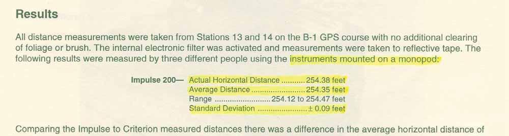
6


7 Tree Height
8 Significance Tree height is used for volume, value and growth & yield determination. Volume (cf) of immature Douglas fir in British Columbia: log V = log D log H So calling a 20" DBH tree that's 120 ft. tall (5% error in height) results in a 5.5% error in volume.
9 Measure from a point perpendicular to the lean tangent solution Timber cruisers have been trained to measure heights from a location that is perpendicular to the lean. This would solve most of the problem except that topography and perception often prevents an accurate measurement. The tree may appear to lean to the right or left but really quarters to you or away from you.
10 Height error when lean is towards the cruiser Tree Height = 100 feet Degree of lean Distance from base of tree 50 feet 100 feet 1 degree 3.6% 1.8% 2 degrees 7.5% 3.6% 5 degrees 33.3% 9.5% 10 degrees 53.2% 21.0% 15 degrees 107.3% 34.9%
11 Leaning Tree Height Improper technique Tangent Height Distance
12 Leaning Tree Height Proper technique Tangent Height Distance

13 Impulse 200 (1996) Main Features: Range: +0.1 foot To a tree 450 to 3,600 feet Tilt accuracy +0.1 degree Tree Heights 3- shot tangent solution

14 Impulse 200 Evaluation by the U.S. Service Forest

15


16 TruPulse 200 / 200B (2004) Accuracy: Distance + 1 ft ; Inclination degrees Range: 0 to 3,280 ft (6,560 ft to reflective target) Operating Modes: Slope, horizontal and vertical distance, 3-point height routine, closest, farthest and continuous target acquisition
17 The most accurate method to measure tree heights is with a laser instrument developed before First, determine the horizontal distance (HD) to the central axis of the tree under the top. HD
18 Then shoot the angle to the base of the tree to determine the vertical distance from the horizontal to the base of the tree. Vertical Distance to BASE
19 Then shoot the angle to the top of the tree to determine the vertical distance from the horizontal to the top of the tree. Vertical Distance to TOP
20 The next push of the firing button solves for tree height. HEIGHT


21 The Next Best Procedure Place a reflector directly under the top of the tree, at the parallel to the base. With the electronic filter turned ON, scan back and forth until the laser locks onto the reflector, fire the laser again to get the base angle and then shoot the angle to the top of the tree. Height
22 Sine-based tree height measurement Tree height = a + a = [(sin A) c] + [(sin A ) c ] The sine method requires a physical target-not just an angle to the top and base of the tree!! c a A A b c a
23 Cosine-based tree height measurement Tree height = a = b 2 +c 2-2bcCosA The cosine method requires a range measurement (b and c) and an angle (A) to the top and base of the tree!! A c Accurate if the tree leans directly towards or away from you. a b

24 The Leaning Pine was a recognizable symbol of a forestry school in the Northeast but also a mensuration course challenge.

25 Tilted Tree Hypsometry by L.R. Grosenbaugh


26 Two Observation Points per Tree are Required


27 TruPulse 360 / 360B (2007) Main Features: Range: Accuracy + 1 foot Maximum range 3,280 feet to typical target (6,560 feet to a reflective target Inclination accuracy: degrees Azimuth accuracy: + 1 degree Height determination: 3-shot tangent solution for height determination 2-shot coordinate solution for height, displacement and length determination
28 Using a TruPulse 360 to Measure Displacement of Top from Base, Vertical Height, Length of Tree Bole and Azimuth from Tree Top to Base The solution requires two shots and is accurate regardless of which way the tree Leans. X, Y, Z X, Y, Z
29 TruPulse 360 / 360B x, y, z VD SD Missing Line (ML) Routine Shot 2 INC HD (AZ) x, y, z Shot 1


30 Missing Line HD Solution Missing Line VD Solution Missing Line SD Solution

31 TruPulse, Reflector and Foliage Filter
 CRV3: Approximately 15,000 measurements (12,000 with Bluetooth")
32 Battery Duration AA: Approximately 7,500 measurements (6,000 with Bluetooth enabled) CRV3: Approximately 15,000 measurements (12,000 with Bluetooth enabled)
33 Crown Width Missing Line Mode Shoot a branch on one side of the crown and then one on the other. Immediately the horizontal distance between the two points is displayed.

34 Determine Tree Spacing


35 Angle Gauges Angle Gauge Prism Spiegelrelaskop Dendrometers Barr & Stroud Criterion


36 Criterion RD Electronic Angle Gauge (2005) BAF range: 1 to 127 ft 2 /acre (0.3 to 29.1 M 2 / Hectare)


37 Solid Bar vs. Gap Bar

38 Illumination Brightness Adjustment


39 BAF 20 Mode Measurement bar length adjusted for slope
40 Point Sampling Trees/acre = BAF / x DBH 2 Trees/acre = 20 / x 8 2 = 57.3 trees/acre
41 Setting Imperial BAF s to Tenths Change measurement unit s to METRIC Return to BAF Mode and EDIT in the metric equivalent: Multiply Imperial BAF by (example: 17.5 BAF x =4.0 metric)
42 IN / OUT Tree Mode Enter DBH either by measuring with the instrument (in DIAMETER mode) or manually Enter horizontal distance from plot center (instrument) to the face of the tree at DBH manually or automatically with LTI laser (Since the Limiting Distance is to the face of the tree at DBH the Plot Radius Factor has been adjusted by the radius at DBH. So the PRF has been reduced by one-half the DBH, expressed in feet (0.5/12 = ). Press ENTER and the LCD and HUD will indicate if the tree is IN or OUT of the plot
43 DIAMETER Mode LCD HUD Display shows DIAMETER when the trigger is released


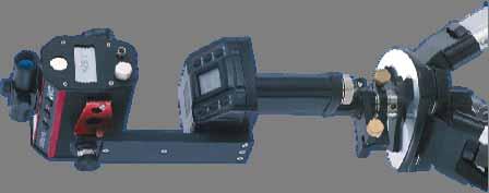
44 Diameter resolution With Magnifier + ¼ inch at 80 feet + 1/8 inch at 40 feet Without Magnifier + 5/8 inch at 80 feet + 3/8 inch at 40 feet
 2L D/2 SINCE: 4L 2 >> S 2 D (S 2 + 2SL) / 2L D S( 1 +")
45 Computation of Diameter S= D 2 L L+D S D/2 D/2 L D= S 2 + S (S 2 +4L 2 ) 2L D/2 SINCE: 4L 2 >> S 2 D (S 2 + 2SL) / 2L D S( 1 + S/2L)
46 Diameter (D) Range / Distance Distance to Face-of-Tree W/O Magnifier With Point of Measurement Min. D Max. D Min. D Max. D


47 HEIGHT / DIAMETER Mode
48 Reference Log Determining Tree Cull Percentage Approximate Percent of Tree Volume by 16-Foot Logs Scribner Dec. C or Cubic Height Height i.e.-if a tree is 86 feet to a 6.0-inch top and has a fire scar in the 1 st log requiring a 2- foot deduction, the tree is 4 % cull.


49 Accessories for the Impulse Lasers MapStar Compass Module MapStar Angle Encoder Accuracy: +0.3 Accuracy: +0.05

50 MapStar Compass Field Test and Overview: by Robert Schroeter, Jack Fetterman and Robert Pierle

51 Conclusion of Field Test

52 Integrated Set-up for Tree Modeling with a TruPulse Laser

53


54 Inventory Plot - Jilove, Czech Republic
55 European Countries Using LTI Products for Forest Inventory NFI Ireland Czech Republic Slovakia Iceland Hungary Ukraine Russia Most Forest Reserves Throughout Europe

56


57 Happy Trails!


")

58 28 Year Old Eastern White Pine (Pinus strobus) Duroflora Company Near Piracicaba, Brazil


59 1-year old Eucalyptus grandis stand 2-year old E. grandis stand 3-year old stand of E. grandis 21 year old E. grandis stand


60 10-year old Pinus radiata stand near Conception, Chile 5 1/2 inch pen

61 Inventory Plot - Pinus radiata Cooma, New South Wales, Australia


62 Pinus radiata Stands Near Ballarat, Victoria, Australia 25-year old stand 40-year old stand
 stand Ballarat,")
63 55 year old Redwood (S. sempervirens) stand Ballarat, Australia


64 25 Year Old Sitka Spruce Plantation - Moffett, Scotland


65 Forest Expo Soustons, France

66 Area Near Schmallenberg, Germany

67 Demonstration Plot - Ministry of Forestry Hdqts.Fontainelleau, France (Napoleon s Estate)
68


69


70 Traditional Surveying Tools- Mid 1950 s Staff compass, chain, Abney level, and Reinhardt Redy Mapper


71 Skull Creek Timber Sale (113 MMBF) Preparation


72 Traditional Cruising Tools Used from the mid 1960 s Until Early 1990 s

73 Introduced the First Laser Designed for Forestry (1992) Features: Determine tree height Locate target height Determine Diameter Locate target diameter BAF 1 to 90 IN / OUT tree Closed surveys Open surveys Combination surveys Store 1,350 points Navigation Criterion 400 Ceased production about 10 years ago. Still used today for stem mapping, traversing, road layout and conductor clearance.
74 The bigger the tree, the bigger the potential for significant error!! Tangent height method Tangent height Actual height
75 Sine-based tree height measurement Less sensitive!! Tree height = a + a = [(sin A) c] + [(sin A ) c ] Provides exact height of branch, not over- or under-estimate!! c a A A b c a
76 Sine-based tree height measurement Tree height = a + a = [(sin A) c] + [(sin A ) c ] Under ideal conditions, tangent height = sine height exactly! A A c b c a a


77 Portable GPS Mid 1980 s Now


78

79 Progression of Texts

80


81


82

83 Integrated Set-up for Tree Modeling with an Impulse Laser
84 Consequences of Distance Error to Tree Height If the cruiser is an equal distance from the tree as the tree is tall (45 degrees viewing angle to the top), for every 1% error in distance from the tree there is a 1% error in height. If nearer the tree there is more than 1% error in height for each 1% error in distance.
85 Solution for Measuring Distances to the Face of Obscured Sections of a Tree With TruPulse 360 laser connected to the Criterion RD dendrometer measure the distance to two clearly visible points on the tree. The slope distance to the point where the diameter measurement is needed can then be calculated based on the inclination and azimuth to that point.
86 Solve the Range to any Point on the Tree Solve tree height = a = b 2 +c 2-2bcCosA B Solve B=Cos B=(a 2 +c 2 -b 2 )/2ac Solve C=180-(A+B) Solve B 1 =180-(A 1 +C) Solve a 1 with Sine Rule: Sine A 1 /a 1 = Sine B 1 / b a 1 =b Sine A 1 /Sine B 1 A A 1 c d B l a Solve d = a 1 +b-2a 1 bcos C b a 1 C
87 Modes of Operation 5 Operating Modes: SYSTEM Used to set operating parameters BAF Used to store the Basal Area Factor (BAF) IN / OUT Used to determine if a questionable tree is in or out of the plot. DIAMETER Used to determine the diameter of a tree at a given height up the tree. HEIGHT / DIAMETER Used to determine the height up the tree at which a specific diameter is reached.
88 Missing Line Calculations Shot 1 - Measurement of target 1: Slope Distance1, Inclination1, and Azimuth1 Shot 2 - Measurement of target 2: Slope Distance2, Inclination2, and Azimuth2 Conversion of Spherical Coordinates to Cartesian: Shot1->x1,y1,z1 Shot2->x2, y2, z2 x1=slope Distance1*sin(Azimuth1)*cos(Inclination1) x2=slope Distance2*2sin(Azimuth2)*cos(Inclination2) y1=slope Distance1*cos(Azimuth1)*cos(Inclination1) y2=slope Distance2*cos(Azimuth2)*cos(Inclination2) z1=slope Distance1*sin(Inclination1) z2=slope Distance2*sin(Inclination2) Missing Line is a Difference of Shot1 and Shot2 Coordinates xml=x2-x1, yml=y2-y1, zml=z2-z1 Conversion of Missing Line Cartesian Coordinates to Spherical Slope Distance=Square root(xml^2+yml^+zml^2) Azimuth=arctan(abs(yml/xml)) Quadrant correction after Azimuth is Converted to Degrees If (xml<0)and(yml>0) add 90, If (xml<0) and (yml<0) add 180 or If (xml>0) and (yml<0) Azimuth=360 Azimuth Finally: Azimuth=450-Azimuth and if (Azimuth>360) Azimuth=Azimuth -360 Inclination=arctan(zml/SquareRoot(xml^2+yml^2))
FOR 274 Forest Measurements and Inventory. Written Take Home Exam
 FOR 274 Forest Measurements and Inventory Written Take Home Exam Instructions: This exam is comprehensive of the material covered within the Forest Resources 274 class curriculum. The first question is
AG. 350 FORESTRY AND WILDLIFE MANAGEMENT
 AG. 350 FORESTRY AND WILDLIFE MANAGEMENT COURSE DESCRIPTION: A course designed to examine the importance of forestry, wildlife, and outdoor recreation with emphasis on efficient use of natural resources.
UNEVEN-AGED MANAGEMENT NORTHWEST CERTIFIED FORESTRY
 UNEVEN-AGED MANAGEMENT NORTHWEST CERTIFIED FORESTRY Rolf Gersonde, 6/6/2015 Uneven-aged Management in 90 Minutes 2 Silviculture Background Forest Ecology Management Tools and Stocking Control Multi-aged
Timber Sale Appraisal Sunday Passage Sale FG
 Timber Sale Appraisal Sunday Passage Sale FG-341-2018-024- District: Forest Grove Date: August 23, 2017 Cost Summary Conifer Hardwood Total Gross Timber Sale Value $3,295,699.11 $68,708.64 $3,364,407.75
Point-3-P Alternative Timber Cruise Procedure Our goal. Our base theory.
 Point-3-P Alternative Timber Cruise Procedure Cruising research conducted by Ken Lucas and Len Nielson Base theory & P-3-P programming support provided by Dr. Kim Iles, www.island.net/~kiles Additional
& What to Look for in a Timber Cruise/Inventory Program
 & What to Look for in a Timber Cruise/Inventory Program CV Paul Wagner ACI Instructor University of Washington: BA, Forest Management, 1980; MBA,1988. Project Manager, employed by Atterbury Consultants
TREE MEASUREMENT. Objective
 TREE MEASUREMENT Objective Contestants will learn to measure standing trees in order to estimate the volume of forest products that may be obtained from the trees. Since most timber is bought and sold
FOREST PARAMETER EXTRACTION USING TERRESTRIAL LASER SCANNING
 FOREST PARAMETER EXTRACTION USING TERRESTRIAL LASER SCANNING P.J.Watt *, D.N.M. Donoghue and R.W. Dunford Department of Geography, University of Durham, Durham, DH1 3LE, United Kingdom *Corresponding author:
WISCONSIN WOODLANDS:
 G3362 WISCONSIN WOODLANDS: Estimating Stocking Conditions In Your Timber Stand Jeff Martin Foresters use the term stocking to indicate the number of trees or basal area per acre in a timber stand an aggregation
The Connected Forest Mobile Apps for Log Management & Measurement
 Trimble Forestry David Buddingh, Channel Account Manager, April 13, 2017 Mobile Apps for Log Management & Measurement Transforming The Way the World Works About Trimble Forestry 100% Owned by Trimble Navigation
Discussion of point sampling exercise
 Discussion of point sampling exercise Comparison of cover values from point quadrat and Buckner Sampler methods. Discussion of LAI (point frame vs. LAI- 2000). Discussion of Buckner Sampler vs. densiometer
Improving Forest Inventory: Integrating Single Tree Sampling With Remote Sensing Technology
 Improving Forest Inventory: Integrating Single Tree Sampling With Remote Sensing Technology C.J. Goulding 1, M. Fritzsche 1, D.S. Culvenor 2 1 Scion, New Zealand Forest Research Institute Limited, Private
PNW-3 53 March 1980 ESTIMATING MERCHANTABLE VOLUMES OF SECOND GROWTH DOUGLAS-FIR STANDS FROM TOTAL CUBIC VOLUME AND ASSOCIATED STAND CHARACTERISTICS
 This file was created by scanning the printed publication. Text errors identified by the software have been corrected; however, some errors may remain. PNW-3 53 March 1980 ESTIMATING MERCHANTABLE VOLUMES
A Comparison of Four Forest Inventory Tools in Southeast Arkansas Brandon Tallant and Dr. Matthew Pelkki. Abstract
 A Comparison of Four Forest Inventory Tools in Southeast Arkansas Brandon Tallant and Dr. Matthew Pelkki Abstract During the summer of 2003, timed measurements on 6,469 trees and 422 fixed radius plots
Forestry Unit. 7.A.3a Measure length, capacity, weight/mass and angles using sophisticated instru ments (e.g., compass, protractor, trundle wheel).
.") Forestry Unit By Bob Blaus York High School Overview These lessons are to be a part of a week long summer wilderness program taken annually by students of my ECO Club on the Flambeau River in northern
Forestry Unit By Bob Blaus York High School Overview These lessons are to be a part of a week long summer wilderness program taken annually by students of my ECO Club on the Flambeau River in northern
UNIVERSITY OF TORONTO MISSISSAUGA TREE INVENTORY
 UNIVERSITY OF TORONTO MISSISSAUGA TREE INVENTORY 4/9/2016 Developing a Tree Inventory for the University of Toronto, Mississauga Campus In an effort to measure biodiversity long term, Environment Canada
FIXED AIR-EASE 70 mm PHOTOGRAPHY, A NEW TOOL FOR FOREST SAMPLING
 FIXED AIR-EASE 70 mm PHOTOGRAPHY, A NEW TOOL FOR FOREST SAMPLING Two basic approaches have been made in the field of ultra large scale forestry photography. One approach uses standard photographic and
Timber Sale Appraisal Buck Ridge. Sale GP Cost Summary. Conifer Hardwood Total. District: Southwest Date: April 23, 2015
 Timber Sale Appraisal Buck Ridge Sale GP-31-2015-88- District: Southwest Date: April 23, 2015 Cost Summary Conifer Hardwood Total Gross Timber Sale Value $68,0.32 $7,950.00 $76,35.32 Project Work: ($19,580.00)
Section 12. Crowns: Measurements and Sampling
 Section 12. Crowns: Measurements and Sampling 3.0 Phase 3 Field Guide - Crowns: Measurements and Sampling 12.1 OVERVIEW...2 12.2 CROWN DEFINITIONS...2 12.3 CROWN DENSITY-FOLIAGE TRANSPARENCY CARD...5 12.4
Integration of high-quality harvester data and new log scaling technology for efficient control of wood flow in German wood supply chains
 Integration of high-quality harvester data and new log scaling technology for efficient control of wood flow in German wood supply chains Dirk Jaeger 1, Martin Opferkuch 1, Siegmar Schönherr 1, Thilo Wagner²
NEW: Element Vertical Lift Module
 Standard Solutions Vertical Lift Module NEW: Element Vertical Lift Module Experience Innovation: The New Kardex Remstar Element Vertical Lift Module High Density Storage: Saving Space, Time And Money STARTIC
Introduction to Growth and Yield Models
 Introduction to Growth & Yield Models Introduction to Growth and Yield Models Introduction to Growth & Yield Models TYPES OF GROWTH AND YIELD MODELS OR SIMULATORS Whole-Stand Whole-Stand/Diameter-Free
Airborne Laser Scanning (ALS) for forestry applications
 for forestry applications") Airborne Laser Scanning (ALS) for forestry applications International School on Lidar Technology 2008 IIT Kanpur, India Norbert Pfeifer + I.P.F.-Team http://www.ipf.tuwien.ac.at/ Christian Doppler Laboratory
Airborne Laser Scanning (ALS) for forestry applications International School on Lidar Technology 2008 IIT Kanpur, India Norbert Pfeifer + I.P.F.-Team http://www.ipf.tuwien.ac.at/ Christian Doppler Laboratory
Change Monitoring Inventory
 Change Monitoring Inventory Ground Sampling Quality Assurance Standards Prepared by Ministry of Forests Resources Inventory Branch for the Terrestrial Ecosystem Task Force Resources Inventory Committee
Lesson 2: Introduction to Plot Sampling
 Lesson 2: Introduction to Plot Sampling Review and Introduction Lesson 1 focused on taking a big picture approach and dividing your forest into individual management units called stands. The next step
A Crown Cover Chart For Oak Savannas
 March, 1994, TB-NC-2 A Crown Cover Chart For Oak Savannas Jay R. Law, USDA Forest Service (retired) Paul S. Johnson, Principal Silviculturist Garry Houf, Forest Biologist, Mark Twain National Forest Although
Timber Sale Appraisal Shepherds Pie Sale cost summary. Conifer Hardwood Total. Gross Timber Sale Value $2,013, $13,263.
 Timber Sale Appraisal Shepherds Pie Sale 341-14-23 District: N Cascade Date: January 14, 2014 cost summary Conifer Hardwood Total Gross Timber Sale Value $2,013,923.22 $13,263.00 $2,027,186.22 Project
Point Sampling (a.k.a. prism cruising)
") Point Sampling (a.k.a. prism cruising) The following is a (simple?) explanation of the principles behind prism cruising. This is not meant as a stand alone paper; it is intended to supplement lecture/lab
Point Sampling (a.k.a. prism cruising) The following is a (simple?) explanation of the principles behind prism cruising. This is not meant as a stand alone paper; it is intended to supplement lecture/lab
Appendix B: Site Index Curves for Selected Tree Species. Interpreting Site Index Curves
 199 Appendix B: Site Index Curves for Selected Tree Species Interpreting Site Index Curves Site index is the height to which trees will grow over a given period usually 50 years in the Lake States. Trees
Plantation Forestry: A Global Look
 Plantation Forestry: A Global Look Forest Area: 3,952,025,000 ha Woodland Area: 1,375,829,000 ha Annual World Wood Removal + + 620,138,943 m 3 wood (USDA 2008) 620,138,943 m 3 wood (USDA 2008) 620,138,943
Change Monitoring Inventory
 Change Monitoring Inventory Ground Sampling Quality Assurance Procedures Prepared by Ministry of Sustainable Resource Management Terrestrial Information Branch for the Terrestrial Ecosystem Task Force
Felling Decision Tool - Conifers
 Silviculture/Management No. 22 COFORD 2016 Estimates timber revenues for the main conifer species. User can select timber prices and rotation type. Estimates the revenue loss for felling earlier than rotation
FOR 274: Forest Measurements and Inventory. Log Rules: Introduction. Log Rules: Introduction
 FOR 274: Forest Measurements and Inventory Log Rules and Scaling Introduction to Log Rules Schribner, Doyle, and International Overrun and Underrun Board Foot Scaling Defects and Culls Measurements Readings:
Hurricane Ike Timber Damage Assessment Texas Forest Service 17 September 2008
 Hurricane Ike Timber Damage Assessment Texas Forest Service 17 September 2008 Hurricane Ike made landfall on Saturday, 13 September 2008, at 2:10 am CDT as a Category 2 storm with 105 mph winds on Galveston
A Simple Procedure for Mapping Tree
 Forest Science, Vol. 35, No. 3, pp. 657-662 Copyright 1989 by the Society of American Foresters A Simple Procedure for Mapping Tree Locations in Forest Stands DAVID D. REED HAL O. LIECHTY ANDREW J. BURTON
Impact of Definitions of FIA Variables and Compilation Procedures on Inventory Compilation Results in Georgia
 Impact of Definitions of FIA Variables and Compilation Procedures on Inventory Compilation Results in Georgia Brock Stewart 1, Chris J. Cieszewski 2, and Michal Zasada 3,4 Abstract. This paper presents
 Greasy Alder TIMBER CRUISE REPORT FY 2010 1. Sale Area Location: Areas 1 and 2 are located in Portions of Sections 33 and 34, T7N, R6W, W.M., Clatsop County, Oregon. 2. Fund Distribution: BOF 100% Tax
Enhancing Data Resolution to Improve Maritime Safety
 Enhancing Data Resolution to Improve Maritime Safety Pacific Northwest Waterways Association 2014 Annual Convention October 15 17 th, Vancouver, WA Jon Dasler, PE, PLS, CH Director of Marine Services,
3D Layout Navigator. The world s first 3D positioning system designed specifically for construction layout.
 LN-100 3D Layout Navigator The world s first 3D positioning system designed specifically for construction layout. The first time you see it you know it s unlike anything you ve seen before. Its clean,
2009 Council on Forest Engineering (COFE) Conference Proceedings: Environmentally Sound Forest Operations. Lake Tahoe, June 15-18, 2009
 Conference Proceedings: Environmentally Sound Forest Operations. Lake Tahoe, June 15-18, 2009") 2009 Council on Forest Engineering (COFE) Conference Proceedings: Environmentally Sound Forest Operations. Lake Tahoe, June 15-18, 2009 Determining Radiata pine tree value and log product yields using
2009 Council on Forest Engineering (COFE) Conference Proceedings: Environmentally Sound Forest Operations. Lake Tahoe, June 15-18, 2009 Determining Radiata pine tree value and log product yields using
Users Guide for Noble Fir Bough Cruiser
 United States Department of Agriculture Forest Service Pacific Northwest Research Station General Technical Report PNW-GTR-644 July 2005 Users Guide for Noble Fir Bough Cruiser Roger D. Fight, Keith A.
Productivity of red alder in western Oregon and Washington
 From Biology of Alder Proceedings of Northwest Scientific Association Annual Meeting April 14-15, 1967 Published 1966 Productivity of red alder in western Oregon and Washington Red alder in western Oregon
NED/SIPS FAQs. NED/SIPS Frequently Asked Questions December 13, 1999 IF YOU GET AN ERROR MESSAGE AFTER INSTALLING NED/SIPS PLEASE SEE QUESTION 48.
 NED/SIPS Frequently Asked Questions December 13, 1999 IF YOU GET AN ERROR MESSAGE AFTER INSTALLING NED/SIPS PLEASE SEE QUESTION 48. Q1. Do I have to have a math coprocessor to run NED/SIPS? Q2. Why does
VB Merch-Slash: A Growth-and-Yield Prediction System with a Merchandising Optimizer for Planted Slash Pine in the West Gulf Region
 United States Department of Agriculture Forest Service VB Merch-Slash: A Growth-and-Yield Prediction System with a Merchandising Optimizer for Planted Slash Pine in the West Gulf Region Southern Research
APPLYING SELECTION SYSTEM SILVICULTURE
 APPLYING SELECTION SYSTEM SILVICULTURE Ralph D. Nyland Department of Forest and Natural Resources Management SUNY College of Environmental Science and Forestry Syracuse, NY 13210 October 2010 All rights
Growth Intercept Method for Silviculture Surveys
 Growth Intercept Method for Silviculture Surveys AUGUST 1995 Canada CANADA-BRITISH COLUMBIA PARTNERSHIP AGREEMENT ON FOREST RESOURCE DEVELOPMENT: FRDA II BC Growth Intercept Method for Silviculture Surveys
Simulating Regeneration Dynamics in Upland Oak Stands
 Simulating Regeneration Dynamics in Upland Oak Stands Powered By Powered by: USDA Forest Service Southern Research Station Dr. David Loftis Powered By Powered by: Regen for Excel is a simulation model
Timber Pricing Branch. Regional Executive Directors, Ministry of Forests, Lands & Natural Resource Operations
 Ministry of Forests, Lands and Natural Resource Operations Timber Pricing Branch MEMORANDUM Ref: 204919 File: 195-30/CRUI February 14, 2014 BY EMAIL To: Re: Regional Executive Directors, Ministry of Forests,
Basic Measuring and Calculations. Formulas, Workings Hints and Tips
 Basic Measuring and Calculations Formulas, Workings Hints and Tips Start by writing down the formula When working out mathematics Ensure you show all working out (Marks will be awarded for working out)
Application of airborne LiDAR in forestry in North America and Scandinavia. ForestrySA LiDAR initiatives
 Application of airborne LiDAR in forestry in North America and Scandinavia ForestrySA LiDAR initiatives Jan Rombouts Airborne LiDAR is a great data source for forestry Transect through LiDAR data set,
MOTTI USER S GUIDE version 3.3. Natural Resources Institute Finland
 MOTTI USER S GUIDE version 3.3 Natural Resources Institute Finland Getting started and software registration Trial period for MOTTI is 30 days. Thereafter, registration is mandatory. Registration is important
LiDAR based sampling for subtle change, developments, and status
 LiDAR based sampling for subtle change, developments, and status Erik Næsset Norwegian University of Life Sciences, Norway 2111 2005 Conclusions: 1. LiDAR is an extremely precise tool for measuring forest
A brief introduction to general terms and concepts related to the forestry learning objectives
 A brief introduction to general terms and concepts related to the forestry learning objectives The profession embracing the science, art, and practice of creating, managing, using, and conserving forests
Tree Measuring Guidelines of the Eastern Native Tree Society Prepared by Will Blozan, ENTS President, October 2004
 Tree Measuring Guidelines of the Eastern Native Tree Society Prepared by Will Blozan, ENTS President, October 2004 Revised March 2008 Introduction The Eastern Native Tree Society is a diverse, non-profit
Southern Pine Tree Size Dynamics Where s the Pulpwood? (Potential Diameter-class Imbalance in Southern Pines)
") Southern Pine Tree Size Dynamics Where s the Pulpwood? (Potential Diameter-class Imbalance in Southern Pines) Southern Forest Products Association Expo University 5 June 2013 Richard A. Harper, CF, RF
Southern Pine Tree Size Dynamics Where s the Pulpwood? (Potential Diameter-class Imbalance in Southern Pines) Southern Forest Products Association Expo University 5 June 2013 Richard A. Harper, CF, RF
Wood is IKEA identity. Forestry Chatham House
 Wood is IKEA identity IKEA Forestry requirements since 1998 Solid Wood Board Materials Paper Catalogue Paper Corrugated Board Paper in Articles Other Paper Million m3 RWE Fresh Wood Raw Material Usage
Elemental Time Studies
 Elemental Time Studies Elemental time studies record times for machine activities: from continuous observation of the machine for a longer period of time Machine time is divided into elements. Each element:
Mule Deer Winter Range Planning. Current And Future Forest Condition Pilot Project. Submitted to:
 Mule Deer Winter Range Planning Current And Future Forest Condition Pilot Project Submitted to: Ministry of Sustainable Resource Management Cariboo Region March, 2003 FIRS Project # 1029-16 Professional
Estimating Leaf Bulk Density Distribution in a Tree Canopy Using Terrestrial LiDAR and a Straightforward Calibration Procedure
 Supplementary Information Estimating Leaf Bulk Density Distribution in a Tree Canopy Using Terrestrial LiDAR and a Straightforward Calibration Procedure Supplementary A. Inventory-Based Method to Estimate
Forest Descriptions and Photographs of Forested Areas Along the Breaks of the Missouri River in Eastern Montana, USA
 United States Department of Agriculture Forest Service Rocky Mountain Research Station General Technical Report RMRS-GTR-186 February 2007 Forest Descriptions and Photographs of Forested Areas Along the
Forest Resources of the United States, 2017: A Technical Document Supporting the Forest Service Update of the 2010 RPA Assessment
 Forest Resources of the United States, 2017: A Technical Document Supporting the Forest Service Update of the 2010 RPA Assessment Abstract Oswalt, Sonja N.; Miles, Patrick D.; Pugh, Scott A.; Smith, W.
12-1. TIMBER ESTIMATION 291
 12-1. TIMBER ESTIMATION 291 FOREST INVENTORY A forest inventory is the procedure for obtaining information on the quantity, quality, and condition of the forest resource, associated vegetation and components,
Improving Hardwood Timber Stands
 Improving Hardwood Timber Stands Extension Bulletin E-1578, December 1991 By Russell P. Kidd and Melvin R. Koelling Department of Forestry More than 10.4 million of Michigan's 18.9 million acres of forest
Terrestrial Laser Scanning in Forest Inventories
 ARTICLE TOWARD INTERNATIONAL BENCHMARKS Terrestrial Laser Scanning in Forest Inventories Measuring Tree Attributes Terrestrial laser scanning (TLS) is an effective technique for acquiring detailed tree
Log Volume Estimation
 Log Volume Estimation Log volumes can be estimated in a number of ways. Most method estimate different portions of the log volume using different formulas. Figure 1 below indicates the most commonly used
CH. 9 WOOD CONSTRUCTION
 CH. 9 WOOD CONSTRUCTION PROPERTIES OF STRUCTURAL LUMBER Grading Load carrying capacity effected by: - Size and number of knots, splits & other defects - Direction of grain - Specific gravity of wood Grading
METHODS FOR ACQUISITION OF BIOMASS COMPARTMENTS
 Austro2007/FORMEC 07: Meeting the eeds of Tomorrows Forests ew Developments in Forest Engineering, October 7 11, 2007, Vienna and Heiligenkreuz Austria METHODS FOR ACQUISITIO OF BIOMASS COMPARTMETS Otto
Forest Resources of the Black Hills National Forest
 United States Department of Agriculture Forest Service Rocky Mountain Research Station August 22 Forest Resources of the Black Hills National Forest Larry T. DeBlander About the author Larry T. DeBlander
Using GIS for Selecting Trees for Thinning
 Stephen F. Austin State University SFA ScholarWorks Faculty Presentations Spatial Science 2005 Using GIS for Selecting Trees for Thinning I-Kuai Hung Arthur Temple College of Forestry and Agriculture,
FOREST SERVICE HANDBOOK WASHINGTON. FSH a - TIMBER VOLUME ESTIMATOR HANDBOOK. Amendment No a Effective xxxx xx, 1993
 FOREST SERVICE HANDBOOK WASHINGTON FSH 2409.12a - TIMBER VOLUME ESTIMATOR HANDBOOK Amendment No. 2409.12a-93-1 Effective xxxx xx, 1993 POSTING NOTICE. Page Code Superseded New (Number of Sheets) (Entire
MICRO-HYDRO INSTALLATION SIZING Jacques Chaurette eng. January 17, 2008
 MICRO-HYDRO INSTALLATION SIZING Jacques Chaurette eng. January 17, 2008 www.lightmypump.com A friend of mine asked me to help size a micro-hydro installation that he was thinking of installing at his cottage.
Estimating Value and Volume of Ponderosa Pine Trees by Equations
 United States Department of Agriculture Forest Service Pacific Northwest Forest and Range Experiment Station Research Paper PNW-283 May 1981 Estimating Value and Volume of Ponderosa Pine Trees by Equations
Predicting productivity using combinations of LiDAR, satellite imagery and environmental data
 Date: June Reference: GCFF TN - 007 Predicting productivity using combinations of LiDAR, satellite imagery and environmental data Author/s: Michael S. Watt, Jonathan P. Dash, Pete Watt, Santosh Bhandari
Using the Landscape Management System (LMS) James B. McCarter, Kevin W. Zobrist Rural Technology Initiative, University of Washington
 James B. McCarter, Kevin W. Zobrist Rural Technology Initiative, University of Washington") Using the Landscape Management System (LMS) James B. McCarter, Kevin W. Zobrist Rural Technology Initiative, University of Washington Introduction What is LMS? Using LMS Outline Stand Scale Analysis Landscape
Using the Landscape Management System (LMS) James B. McCarter, Kevin W. Zobrist Rural Technology Initiative, University of Washington Introduction What is LMS? Using LMS Outline Stand Scale Analysis Landscape
Needed: Guidelines for Defining Acceptable Advance Regeneration
 United States Department of Agriculture Forest Service Intermountain Forest and Range Experiment Station Ogden, UT 84401 Research Note INT- 341 July 1984 Needed: Guidelines for Defining Acceptable Advance
ESTIMATION OF TREE SIZE DISTRIBUTIONS BY COMBINING VERTICAL AND HORIZONTAL DISTRIBUTION OF LASER MEASUREMENTS WITH EXTRACTION OF INDIVIDUAL TREES
 ESTIMATION OF TREE SIZE DISTRIBUTIONS BY COMBINING VERTICAL AND HORIZONTAL DISTRIBUTION OF LASER MEASUREMENTS WITH EXTRACTION OF INDIVIDUAL TREES Johan Holmgren and Jörgen Wallerman Swedish University
REQUEST FOR TIMBER BIDS Blue River Timber Sale Section 21, T16S, R4E, Lane County, Oregon Acre Clearcut
 LAND SURVEYING PLANNING ENGINEERING WATER RIGHTS FORESTRY GPS & GIS TELEPHONE (54) 267-2872 FAX (54) 267-0588 www.stuntzner.com 705 South 4 th Street PO Box 8 Coos Bay, Oregon 97420 COOS BAY FOREST GROVE
THE B.F. GRANT SPACING STUDY: RESULTS THROUGH AGE 19
 THE B.F. GRANT SPACING STUDY: RESULTS THROUGH AGE 19 Plantation Management Research Cooperative Daniel B. Warnell School of Forest Resources University of Georgia PMRC Technical Report 2002-6 April 17,
MACHINE AND LABOR TIMES REQUIRED TO IMPLEMENT KENTUCKY'S SKID TRAIL EROSION CONTROL AND REVEGETATION BMPS
 MACHINE AND LABOR TIMES REQUIRED TO IMPLEMENT KENTUCKY'S SKID TRAIL EROSION CONTROL AND REVEGETATION BMPS Scott Shouse, Jeff Stringer, Matthew Smidt 1, Matthew Pelkki, Jim Ringe, and Randy Kolka Department
How would you measure shrub cover here? FOR 274: Forest Measurements and Inventory. Density: What is it?
 How would you measure shrub cover here? Message of the Day: Quadrat & Line Intercept methods are used in multiple disciplines and are all essentially the same FOR 274: Forest Measurements and Inventory
NZQA registered unit standard version 1 Page 1 of 7. Fell trees in a commercial forest harvesting operation
 Page 1 of 7 Title Fell trees in a commercial forest harvesting operation Level 3 Credits 10 Purpose This unit standard is designed for people who work as a tree feller on a day-to-day basis in a commercial
REDD Methodological Module. Estimation of emissions from market effects LK-ME
 LK-ME - 1 REDD Methodological Module Estimation of emissions from market effects LK-ME Version 1.0 - June 2010 I. SCOPE, APPLICABILITY AND PARAMETERS Scope This module allows for estimating GHG emissions
Gross Measurement Procedures 6
 Gross Measurement Procedures 6 November 1, 2011 6-1 Scaling Manual Ministry of Forests, Lands and NRO Scaling plays a critical role in fulfilling the financial responsibility of the Crown to its forest
Forest biomass by component for the coterminous United States Forest Products Society International Convention June 20, 2010 Madison, WI Pat Miles
 Forest biomass by component for the coterminous United States Forest Products Society International Convention June 20, 2010 Madison, WI Pat Miles Outline 1. FIA sample design 2. Biomass components pre-aug
Decision 16/CMP.1 Land use, land-use change and forestry
 Page 3 Decision 16/CMP.1 Land use, land-use change and forestry The Conference of the Parties serving as the meeting of the Parties to the Kyoto Protocol, Affirming that the implementation of land use,
Section 14. Down Woody Materials
 Section 14. Down Woody Materials 14.0 INTRODUCTION... 3 14.1 DEFINITION OF DOWN WOODY MATERIALS... 3 14.2 LOCATING AND ESTABLISHING LINE TRANSECTS... 4 14.2.1 CWD transects... 4 14.2.2 FWD transects...
Assessment of the Benefits of Ecosystem Restoration with i-tree Eco
 Assessment of the Benefits of Ecosystem Restoration with i-tree Eco Jason Henning, The Davey Institute and US Forest Service Philadelphia Urban Field Station Talk Outline What is i-tree? What does i-tree
HARVESTING/PROCESSING HEADS 200 SERIES
 HARVESTING/PROCESSING HEADS 200 SERIES It s no coincidence that Waratah has been an industry-leader for over 40 years. Because we ve always listened to you to design durable, more productive and efficient
HOBO Plug Load Logger (UX ) Manual
 Manual") HOBO Plug Load Logger (UX120-018) Manual The HOBO Plug Load logger is designed to monitor energy consumption of AC-powered plug in loads. This compact device can be used as a power meter with its built-in
HOBO Plug Load Logger (UX120-018) Manual The HOBO Plug Load logger is designed to monitor energy consumption of AC-powered plug in loads. This compact device can be used as a power meter with its built-in
WEST VIRGINIA DIVISION OF FORESTRY STATE FOREST STANDARDS for LOGGING ROADS AND SKID TRAILS HAUL ROADS
 WEST VIRGINIA DIVISION OF FORESTRY STATE FOREST STANDARDS for LOGGING ROADS AND SKID TRAILS HAUL ROADS The objective of these specifications is to provide the construction requirements for haul roads and
Chapter 4.1. Estimating Manure Inventory. learning objectives
 Estimating Manure Inventory learning objectives Briefly explain the importance of determining manure weight or volume. Estimate the weight of solid manure in a pile. Estimate the volume of liquid manure
Block Planning and Plot Layout 4
 Block Planning and Plot Layout 4 A good survey plan is essential to an efficient waste survey. April 1, 2007 Amendment No. 7 4-1 Prov. Log. Residue & Waste Measure. Proced. Manual Ministry of Forests and
New Zealand. A Submission to the Ad-Hoc Working Group on Further Commitments for Annex I Parties under the Kyoto Protocol (AWG-KP)
") New Zealand A Submission to the Ad-Hoc Working Group on Further Commitments for Annex I Parties under the Kyoto Protocol (AWG-KP) Land Use, Land Use Change and Forestry (LULUCF) Introduction 26 MAY 2009
New Zealand A Submission to the Ad-Hoc Working Group on Further Commitments for Annex I Parties under the Kyoto Protocol (AWG-KP) Land Use, Land Use Change and Forestry (LULUCF) Introduction 26 MAY 2009
Job-made ladders for construction
 Data Sheet 1-568 Rev. April 2016 Job-made ladders for construction This data sheet covers the fabrication and installation of ladders usually made on the job and installed in a semipermanent location as
Future supply of timber and engineered wood products to Australian markets
 Building construction with prefabricated timber and engineered wood Future supply of timber and engineered wood products to Australian markets Frame Australia 2016 Conference and Exhibition Erkki Välikangas
PRODUCT INFORMATION. DWS Pallet MEASURING AND WEIGHING PALLETS AND OTHER BULKY FREIGHT ITEMS. Track and trace systems
 PRODUCT INFORMATION DWS Pallet MEASURING AND WEIGHING PALLETS AND OTHER BULKY FREIGHT ITEMS Track and trace systems 2 DWS Pallet TRACK AND TRACE SYSTEMS SICK 8018446/2015-11-19 PRECISION THAT PAYS OFF
Figure 1 Shear wall segments with mono-sloped top plates
 All text, images and diagrams Copyright 2004 by Thor Matteson and ICC APPENDIX B ENGINEERING PRINCIPLES OF SHEAR WALLS WITH SLOPING TOP PLATES APA The Engineered Wood Association and others have tested
FORESTRY TALK: A GLOSSARY OF COMMON TERMS
 FORESTRY TALK: A GLOSSARY OF COMMON TERMS If you re planning to harvest trees in your woodlot or to establish a forest on your property, you may need to communicate with foresters and logging contractors
Cornish Hardwood Management Area (CHMA)
") 2% 9% 11% 17% 23% 35% Cornish Hardwood Management Area (CHMA) The CHMA covers 14,882 acres and includes County and State administered land for which a joint forest management plan was developed. Dominant
2% 9% 11% 17% 23% 35% Cornish Hardwood Management Area (CHMA) The CHMA covers 14,882 acres and includes County and State administered land for which a joint forest management plan was developed. Dominant