Enhancing Data Resolution to Improve Maritime Safety
|
|
|
- Benjamin Armstrong
- 6 years ago
- Views:
Transcription


1 Enhancing Data Resolution to Improve Maritime Safety Pacific Northwest Waterways Association 2014 Annual Convention October th, Vancouver, WA Jon Dasler, PE, PLS, CH Director of Marine Services, David Evans and Associates, Inc.

2 Maritime Traffic is Pressing the Limits of our Inland Waterways Current navigation charts are not of sufficient resolution for inland and harbor piloting Port surveys are not readily available to the pilot in a clear and concise format for key decision making Critical soundings are not readily available to the pilot Key infrastructure at marine terminals for safe docking in restricted visibility is not readily available


3 Traditional Nautical Chart on the Columbia River Pros Easy to read Low chart clutter Supported by object detection surveys in most critical areas Cons Chart scale does not adequately support inland navigation Does not adequately cover marine terminals No soundings in Federal channels Not updated at a frequency to depict shifting sediments (40% of soundings on US nautical charts predate 1940 and are partial coverage based on lead lines)


4 Implementation of USACE Soundings into Pilot software Pros More frequent surveys to depict changing sediments Tighter spaced soundings with data in the channel Eliminates need for Channel Condition Report
 Pros Ability to")

5 Kalama Export with USACE Soundings in TransView32 (TV32) Pros Ability to customize display in TV32 43 foot contour charted as red Soundings less than 43 feet shown as red
 Pros Chart clutter reduced")


6 Kalama Export with USACE Soundings in TransView32 (TV32) Pros Chart clutter reduced by non-critical soundings dropped from display at larger scale displays Cons Partial coverage single beam data Surveys do not adequately cover marine terminals Not object detection surveys


7 Obstruction Detected by Multibeam Sonar Example of multibeam detected obstruction missed by single beam soundings ft CRD

8 Object Detection Multibeam Surveys for Port of Portland Surveys conducted annually after spring freshet Data acquired and processed to NOAA object detection standards Local high points identified for possible investigation and removal Traditionally provided to Pilots as a hard copy map Data not available for real-time navigation


9 Object Detection Multibeam Surveys for Port of Portland

10 High Resolution Multibeam Surveys Provide Multiuse Data Surveys serve many purposes for Port and Marine Terminal Managers. Data may be used for dredging evaluation, monitoring of structures, evaluation of slope stability, addressing environmental concerns, planning and navigation. The challenge is how to process and present this high resolution data to be useful to mariners in real-time without chart clutter to improve maritime safety.

11 Object Detection Using Multibeam Soundings and Imagery No statistical editing that miss obstructions

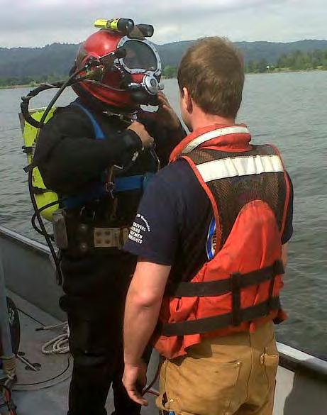
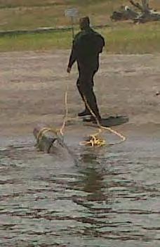
12 Objects Flagged for Investigation and Removed by Divers

13 Port of Portland Hydrographic Surveys Converted to TV32 In 2013 Port of Portland tasked DEA with converting CAD files of terminals and annual surveys into a useful display in TV32. Annual surveys are provided to pilots as updated soundings and critical contours.

14 Port of Portland Hydrographic Surveys Converted to TV32 Soundings resorted for TV32 All soundings represent least depth in the area critical to navigation Berth stationing provided for docking in reduced visibility and bow thruster protection areas added


15 DEA Expanded this Service to Kalama Export and other Terminals
.")
16 Survey Included Precise Positioning of Pier and Fender Line Display of Pier and Fender Line in Columbia River Pilot s portable pilot software TransView 32 (TV32). Data is loaded in TV32 as geographic (Lat/Long) shape files.

 50")


17 Shoal Biased Sounding Selection of Multibeam Data (How it Works) 50 ft radius selection limit 49.4 Fender Line Clip Line

18 Final Display presented to Pilot in TV32 Clear Display of critical soundings Critical depth contour shown in red Critical soundings shown in red Detail of pier provided for docking in reduced visibility No chart clutter to distract Pilot

19 Detail of TEMCO Terminal in TV32 produced by DEA Precise survey of the fender system was used to determine a projected fender line. CAD files positioned based on survey of key features. DEA is adding a tide gauge, visibility sensor and current meter to be broadcast over AIS and displayed in TV32 along with other PORTS data.


20 Port of Portland Hydrographic Surveys Converted to TV32 TV32 real-time display of ship at Port of Portland Berth 601 illustrates need for precise positioning of marine terminal infrastructure


21 DEA 2009 Survey of the Lower Columbia and Willamette for NOAA 65 Uncharted Dangers to Navigation Uncharted Features 200+ Disproved Features Data available for augmentation of TV32

22 Prescott Anchorage Sounding Selection Produced for Pilots DEA worked with the Columbia River Pilots to provided a useful sounding set from the NOAA survey at Prescott Anchorage. Annual object detection surveys of anchorages on the Columbia should be considered.


23 Blue Marlin Delivery of Dry Dock Vigorous (TV32 in Action)

24 Blue Marlin Delivery of Dry Dock Vigorous Blue Marlin Particulars Beam 208 ft Length widest Beam 737 vessel 358 ft standard ft to with ply Vigorous the Panamax Columbia River and almost double the width of a standard 106 ft beam Panamax vessel


25 Bridge Outline and Critical Soundings at BNRR Bridge Data from surveys for NOAA Office of Coast Survey were processed for critical soundings on fixed hard objects, pier outlines precisely outlined and center of bridge positioned in TV32 for Pilots.


26 High Resolution Multibeam Survey of Offload Site DEA was contracted by Vigor to conduct a current survey of the offload site and develop a useful data set to support Columbia River Pilots in this unprecedented mission in the Portland Harbor

27 High Resolution Multibeam Survey of Offload Site Critical contours, selected soundings and bottom image all loaded into TV32 for mission planning and real-time navigation.

28 TV32 Image of Blue Marlin Navigating Through St Johns RR Bridge Buffer of dry dock overhang Note critical soundings on fixed hard objects not shown in single beam surveys

29 Blue Marlin Setting Starboard Anchor

30 Blue Marlin On Station for Offloading Vigorous

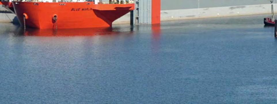
31 Blue Marlin Offloading Vigorous


32 Height Survey of Lewis and Clark Bridge in Longview, WA Tide: Tide: ft ft Ship Ship Height: ft ft DEA recently performed a vessel based laser scan of the Lewis and No No Clearance Clark Bridge to chart clearances relative to the water level reported at the NOAA Clearance water level < < 1.5 gauge 1.5 ft ft in Longview. Clearance >2 >2 ft ft The objective is to provide real-time clearance at intervals across the span relative to actual water level observations at the time of passing. Data above is only shown as an example and does not depict actual height at the tide shown.
33 Final Thoughts As ships get bigger and dynamic under keel clearance is pushed to the margins of existing uncertainty, the need for more accuracy becomes magnified. Pressures to move ships in reduced visibility demand accurate positioning of terminal infrastructure (fender lines, berth stationing, upland features for reference, etc.) to provide pilots with better tools to improve safety margins. With advancements in positioning methods also comes the requirement for more accurate data. A real-time system is already available on the Columbia to provide 2 cm (1 inch) accuracy. With new technology, the ability to gather new accurate data is unparalleled. A laser scan of the Longview Bridge, just a few years ago was un-thought of when moving cranes under the bridge. Today it is a reality that will allow large cruise ships to use the new dry dock at Swan Island.
34 David Evans and Associates, Inc. Marine Services Division Vancouver, WA Jon L. Dasler, PE, PLS, CH Director of Marine Services
Distribution Restriction Statement Approved for public release; distribution is unlimited.
 CECW-EH-D Regulation No. 1110-2-1404 Department of the Army U.S. Army Corps of Engineers Washington, DC 20314-1000 Engineering and Design HYDRAULIC DESIGN OF DEEP-DRAFT NAVIGATION PROJECTS Distribution
Growth In Container Volumes
 US GDP and TEU Trade: 1980-2005 600 Recession Total US TEUs 500 US GDP 400 300 200 100 0 1980 1981 1982 1983 1984 1985 1986 1987 1988 1989 1990 1991 1992 1993 1994 1995 1996 1997 1998 1999 2000 2001 2002
The Port ENC part of e-navigation, RIS, VTS, AIS Results of the integrated EU research project EFFORTS
 The Port ENC part of e-navigation, RIS, VTS, AIS Results of the integrated EU research project EFFORTS September 13-16, 2011, New Orleans, Louisiana, USA The integrated EU research project EFFORTS (May
QPS NAUTICAL CHARTING WORKFLOW: Walking a ping from the surveyor all the way to the pilot
 QPS NAUTICAL CHARTING WORKFLOW: Walking a ping from the surveyor all the way to the pilot Matthew Wilson 1,*, and Frans Nijsen 2, 1 email: matthew.wilson@qps-us.com; 2 email: nijsen@qps.nl Quality Positioning
Measures for Congestion at Ports. Doug McDonald U.S. Maritime Administration Office of Policy and Plans
 Measures for Congestion at Ports Doug McDonald U.S. Maritime Administration Office of Policy and Plans 1 MAP-21 (Moving Ahead for Progress in the 21 st Century Act) Directs the creation of a national freight
SafePilot Piloting with one touch
 Trelleborg MARINE SYSTEMS SafePilot Piloting with one touch The Smarter Approach Transferring know-how for smarter LNG The smarter approach for a more efficient port Materials best practice for a smarter
Packer Avenue Marine Terminal operator:
 Packer Avenue Marine Terminal operator: Delaware River Main Channel Deepening PhilaPort Channel Deepening: 85% Complete Delaware River Main Channel Deepening Project Details Current Depth vs. Future Depth
APPENDIX E: RIVERFRONT ACCESS, DREDGING AND MARINE INFRASTRUCTURE ASSESSMENT REPORT
 APPENDIX E: RIVERFRONT ACCESS, DREDGING AND MARINE INFRASTRUCTURE ASSESSMENT REPORT This Page Intentionally Left Blank RIVERFRONT ACCESS, DREDGING, AND MARINE INFRASTRUCTURE ASSESSMENT REPORT BARLOW POINT
Project Overview. Northwest Innovation Works LLC and the Port of Kalama propose to develop and operate
 Project Overview Northwest Innovation Works LLC and the Port of Kalama propose to develop and operate a natural gas-tomethanol production plant and storage facilities, and a new marine terminal, in the
How to handle actual requirements of ENC users and data producers in the Port of Hamburg. 29th October 2013
 How to handle actual requirements of ENC users and data producers in the Port of Hamburg 29th October 2013 How to handle actual requirements of ENC users and data producers in the Port of Hamburg Contents
e-navigation and practical applications to monitor and improve the Marine Transportation System
 e-navigation and practical applications to monitor and improve the Marine Transportation System TRB-CMTS R&D Conference 26 June 2012 Diagnosing the Marine Transportation System: Measuring Performance and
Woodfibre LNG Limited Response to SIGTTO LNG Ports and Risk Reduction Options
 Woodfibre LNG Limited Response to SIGTTO LNG Ports and Risk Reduction Options Introduction: The following is in response to the Environmental Assessment Office request for the Society of International
The Economic Benefits of Hydrography and Ocean Mapping
 OVERVIEW The Economic Benefits of Hydrography and Ocean Mapping FIG 6th Regional Meeting, San Jose, Costa Rica 2007 Commission 4: Hydrography Gordon Johnston Venture Geomatics Limited gordon.johnston1@orange.net
Priority Setting Process For Hydrographic Surveys Page 1 of Parameter 1 - Quality of Survey Data Currently Available... 9
 Priority Setting Process For Hydrographic Surveys Page 1 of 25 Contents 1 Scope... 4 2 Related Standards... 4 Symbols (& Abbreviated Terms)... 5 4 Prioritising Parameters... 6 5 Weighting... 7 6 Issuing
The Port ENC a proposal for a new port related ENC standard. The EFFORTS project
 The Port ENC a proposal for a new port related ENC standard Combined 20 th TSMAD and 2nd DIPWG Meeting 3 to 7 May 2010 (Rostock, Germany) The EFFORTS project A general remark: Port ECDIS was the EFFORTS
PIANC Commission Working Group Report Reviews
 PIANC Commission Working Group Report Reviews EnviCom Working Group report details Initial review: conclusion * If identified as potentially sensitive, please highlight the particular areas of potential
Quantifying the Impacts of Shoaling in Navigation Channels via Historical Waterborne Commerce Data
 Quantifying the Impacts of Shoaling in Navigation Channels via Historical Waterborne Commerce Data Kenneth Ned Mitchell, PhD U.S. Army Engineer Research and Development Center CAPT David MacFarland NOAA
House Select Committee on Strategic Transportation and Long Term Funding Solutions. November 6, 2017
 House Select Committee on Strategic Transportation and Long Term Funding Solutions November 6, 2017 1 Welcome to N.C. Ports Fast Facts Two locations serving the Carolinas Over 350,000 teus Over 4 million
Cook Inlet Navigation Channel
 Cook Inlet Navigation Channel Cook Inlet Navigation Channel Page 2 of 9 Condition of Improvements 31 December 2017 Cook Inlet Navigation Channel, Alaska (CWIS No. 010324, 010534) Authorization (1) Water
Longview, WA. Kalama, WA PROJECT SITE. PROJECT: Kalama Manufacturing and Marine Export Facility Project FIGURE 1: VICINITY MAP
 Longview, WA Esri, HERE, DeLorme, MapmyIndia, OpenStreetMap contributors, and the GIS user community PROJECT SITE 0 2,875 5,750 11,500 Feet PURPOSE: Construct a facility to manufacture and exp IN: Columbia
Korea to Vancouver, Wa. by ship discharge directly to river barge transit time about 15 days.
 Korea to Vancouver, Wa. by ship discharge directly to river barge transit time about 15 days. Traditional routes from the Far East to Ft. McMurray Houston, Tx. Ocean voyage 9,979 nm 32 days at 14 kn. Road
Challenges with Evaluating Container Port Projects and the Corps of Engineers
 Challenges with Evaluating Container Port Projects and the Corps of Engineers Smart Rivers Conference 14 September 2011 Kevin Knight Economist Institute for Water Resources U.S. Corps of Engineers 1 Trends
Waterborne Commerce Statistics Center
 Waterborne Commerce Statistics Center Amy Tujague, Special Requests Project Manager Waterborne Commerce Statistics Center Navigation & Civil Works Decision Support Center USACE 30 March 2016 US Army Corps
US Army Corps of Engineers Future of Navigation
 US Army Corps of Engineers Future of Navigation Jeff Lillycrop Brian Tetreault US Army Corps of Engineers Engineer Research and Development Center Presentation Outline Inland Electronic Charts Hydrographic
JACKSONVILLE HARBOR DEEPENING MAYOR S TASK FORCE
 JACKSONVILLE HARBOR DEEPENING MAYOR S TASK FORCE Presented by: Colonel Alan Dodd Jacksonville District, U.S. Army Corps of Engineers August 7, 2014 47-foot Deepening 2.7 BCR Total Federal Cost: $ 312.7
e-navigation and it s applicability to inland waterways
 e-navigation and it s applicability to inland waterways Brian Tetreault U.S. Army Corps of Engineers ERDC Coastal and Hydraulics Laboratory e-navigation International definition (IMO, IALA): e-navigation
PUBLIC NOTICE for Permit Application
 PUBLIC NOTICE for Permit Application 30-Day Notice Issue Date: January 13, 2016 Expiration Date: February 12, 2016 US Army Corps of Engineers No: NWP-2005-426 Oregon Department of State Lands No: 58607-RF
Intelligent Exploitation of the Blue Economy - A Hydrographic Perspective
 Intelligent Exploitation of the Blue Economy - A Hydrographic Perspective Don Ventura Fugro Pelagos, Inc. Meso-American and Caribbean Hydrographic Commission, St. Maarten December 2013 Introduction Blue
THE M4 CORRIDOR AROUND NEWPORT PUBLIC LOCAL INQUIRY
 THE M4 CORRIDOR AROUND NEWPORT PUBLIC LOCAL INQUIRY SUMMARY PROOF OF EVIDENCE Rod Lewis ASSOCIATED BRITISH PORTS Newport Dock Marine Operations 1 PERSONAL BACKGROUND 1.1 My name is ROD LEWIS. I am the
Port ENCs delivering Enhanced Situational Awareness. Caroline Levey Operations Director OceanWise
 Port ENCs delivering Enhanced Situational Awareness Caroline Levey Operations Director OceanWise Introduction Challenges for Ports Why use a Port or Bathymetric ENC Case Studies Brent Delta Clydeport Southampton
Gateway Infrastructure Development Programs in Urban Centers on the west coast of North America
 November 16, 2011 Gateway Infrastructure Development Programs in Urban Centers on the west coast of North America Capacity Improvements Congestion & Air Emissions Mitigation & Community Amenities Mark
Massachusetts Port Authority Subordinated Obligations, Crane Financing and Commercial Paper Notes
 Massachusetts Port Authority Subordinated Obligations, Crane Financing and Commercial Paper Notes TEFRA Hearing April 11, 2018 1. Overview of Conley Terminal Berth 10 & Cranes and other Maritime improvements
Hydrokinetic Project Development
 Hydrokinetic Project Development Presented at the Alaska Rural Energy Conference, Fairbanks, AK April 29,2010 Monty Worthington, Director of Project Development Ocean Renewable Power Company Overview Developer
Sebastian Degens, Port of Portland Marine Planning & Development Manager May19, 2010
 Sebastian Degens, Port of Portland Marine Planning & Development Manager May19, 2010 Goals of the Presentation: Sustainable port development Survey of best practices Lessons from 4 types of applied projects:
Maritime Work Plan for the High Rise Bridge Construction
 Maritime Work Plan for the High Rise Bridge Construction Version 6, 10/3/2018 I 64 Southside Widening & High Rise Bridge, Phase 1 Chesapeake, Virginia Design Build Project State Project No.: 0064 131 811,
Using Port ENCs for Decision Support. Caroline Levey Operations Director OceanWise
 Using Port ENCs for Decision Support Caroline Levey Operations Director OceanWise Introduction Challenges for Ports Why use a Port or Bathymetric ENC Simple steps to create PENC/bENC Case Studies Brent
Waterborne Commerce Statistics Center
 Waterborne Commerce Statistics Center Amy Tujague, Data Liaison Waterborne Commerce Statistics Center Navigation and Civil Works Decision Support Center Institute for Water Resources 19 April 2018 US Army
Port Planning Texas City International Terminal. William L. Allen, PE, SE*; Christopher B. Cornell, PE, SE**; and Dr. Joseph Moseley, PE***
 Port Planning Texas City International Terminal William L. Allen, PE, SE*; Christopher B. Cornell, PE, SE**; and Dr. Joseph Moseley, PE*** *Senior Project Manager, BERGER/ABAM Engineers Inc.; 33301 Ninth
Baltimore Harbor & Channels 50-Foot Project, MD & VA Notice of Intent to Prepare a Supplemental Environmental Impact Statement (SEIS)
") Baltimore Harbor & Channels 50-Foot Project, MD & VA Notice of Intent to Prepare a Supplemental Environmental Impact Statement (SEIS) Public Scoping Meetings November 19 & 24, 2014 US Army Corps of Engineers
Baltimore Harbor & Channels 50-Foot Project, MD & VA Notice of Intent to Prepare a Supplemental Environmental Impact Statement (SEIS) Public Scoping Meetings November 19 & 24, 2014 US Army Corps of Engineers
LOADING OF BULK LIMESTONE AT MUSANDAM ANCHORAGE
 LOADING OF BULK LIMESTONE AT MUSANDAM ANCHORAGE NAVIGATION TO MUSANDAM ANCHORAGE The Bulk Carrier will approach the Musandam Peninsula while respecting the split navigation channels at the Strait of Hormuz.
ESA Considerations for Columbia River Vessel Traffic
 ESA Considerations for Columbia River Vessel Traffic Pacific Northwest Waterways Association 2017 Annual Convention Brent Carson Matthew Love October 18, 2017 Roadmap Lower Columbia River Projects Update
Metrics and Indicators of Coastal Infrastructure Resilience for Marine Transportation
 Metrics and Indicators of Coastal Infrastructure Resilience for Marine Transportation Presenter: Marin Kress, PhD USACE-ERDC Coastal & Hydraulics Lab Navigation Branch Marin.M.Kress@usace.army.mil NOAA
Request for Information RFI THE CHESAPEAKE BAY BRIDGE AND TUNNEL DISTRICT
 Request for Information April 8, 2016 RFI THE CHESAPEAKE BAY BRIDGE AND TUNNEL DISTRICT Chesapeake Bay Bridge and Tunnel District 32386 Lankford Highway Cape Charles, VA 23310 Request for Information:
Port of Vancouver Strategic Plan Update
 COMMUNITY OPEN HOUSE # SUMMARY Date / Time: Tuesday, June, 4: : PM Location: Gaiser Student Center, Clark College Attendees: 5 people signed in Comment forms submitted: 5 Dots placed:,5; 5 green, blue
MARIN Seminar "VTS, een uitdagende toekomst"
 MARIN Seminar "VTS, een uitdagende toekomst" Toekomstige VTS-systemen Dominic Jarvis Sarnia Maritime b.v. Wageningen 23 april 2010 VTS definition a service implemented by a competent authority, designed
Creating Baseline Analytics and Automated Reporting for Improved Decision Making in the Maritime Transportation System
 Creating Baseline Analytics and Automated Reporting for Improved Decision Making in the Maritime Transportation System Jason Tieman, Director of Maritime Solutions June 26-28, 2012 Better visibility leads
e-navigation Frequently Asked Questions
 e-navigation Frequently Asked Questions 1. What is e-navigation? e-navigation is an International Maritime Organization (IMO) led concept based on the harmonisation of marine navigation systems and supporting
Eric Thomas Benchmark River and Rail Terminals
 Eric Thomas Benchmark River and Rail Terminals CORBA s Mission The Central Ohio River Business Association (CORBA) is an alliance of businesses and industry engaged in river commerce on and along the Ohio
PORTLAND HARBOR SUPERFUND CLEANUP MOVING FORWARD TO A RESPONSIBLE, COLLABORATIVE SOLUTION
 PORTLAND HARBOR SUPERFUND CLEANUP MOVING FORWARD TO A RESPONSIBLE, COLLABORATIVE SOLUTION The Port of Portland is committed to a cleanup of the Lower Willamette River that protects the health of Portlanders
Supply Chain Management Summit August 23, 2012
 Supply Chain Management Summit August 23, 2012 Steven J. King, P.E. Managing Director Quonset Business Park 3,207 Total Acres 168 Companies 8,800 Jobs Transportation Facilities Freight Seaport: 2 piers
S-100 PROPOSAL FOR ONLINE DATA EXCHANGE. Why do we need it? How do we achieve it?
 S-100 PROPOSAL FOR ONLINE DATA EXCHANGE Why do we need it? How do we achieve it? vs. Static Data Static Data Collect all Information first -> Build a dataset Process data as a whole Mostly PULL Continuously
Energy Facility Siting Relative to Federal Navigation Projects. Payson R. Whitney, III, P.E.
 Energy Facility Siting Relative to Federal Navigation Projects Payson R. Whitney, III, P.E. Vice President ESS Group, Inc. Environmental Business Council of New England Energy Environment Economy Energy
Puget Sound Maritime Air Emissions Inventory
 Puget Sound Maritime Air Emissions Inventory Pacific Ports Conference on Clean Air Policies and Strategies December 14, 2006 Barbara Cole 1 Puget Sound Region Attainment Status We appreciate living and
40 YEARS OF MARINE OPERATIONS & ENGINEERING IN HAWAII. Makai Research Pier, Waimanalo, Hawaii. 863 N. Nimitz Hwy, Honolulu Harbor
 40 YEARS OF MARINE OPERATIONS & ENGINEERING IN HAWAII Makai Research Pier, Waimanalo, Hawaii 863 N. Nimitz Hwy, Honolulu Harbor Santa Cruz, California www.seaengineering.com ABOUT US Sea Engineering, Inc.
The Economic Realities of Water Transportation
 The Economic Realities of Water Transportation Wayne K. Talley Executive Director, Maritime Institute Frederick W. Beazley Professor of Economics Old Dominion University Short Sea Shipping Short sea shipping
Maritime Intelligence Risk Suite. Whatever your risk...
 Maritime Intelligence Risk Suite Whatever your risk... Identifying and evaluating maritime risk is a challenging business for marine insurers, finance, ship owners, operators and security agencies. In
e-navigation & River Information Services Inland Waterways Users Board Meeting Pittsburgh, PA 06 June 2012
 e-navigation & River Information Services Inland Waterways Users Board Meeting Pittsburgh, PA 06 June 2012 Brian Tetreault US Army Corps of Engineers Engineer Research & Development Center Coastal and
NOAA s Physical Oceanographic Real-Time Systems (PORTS )
") NOAA s Physical Oceanographic Real-Time Systems (PORTS ) Darren Wright and Robert Bassett National Oceanic and Atmospheric Administration (NOAA) 1305 East West Highway Silver Spring, MD 20910 Abstract
NOAA s Physical Oceanographic Real-Time Systems (PORTS ) Darren Wright and Robert Bassett National Oceanic and Atmospheric Administration (NOAA) 1305 East West Highway Silver Spring, MD 20910 Abstract
INFORMATION BULLETIN No. 51
 Bulletin No. 51 Revision No. 08 Issue Date 14 Nov 2017 Effective Date 14 Nov 2017 INFORMATION BULLETIN No. 51 ECDIS, Nautical Charts and Publications Guidance and Instructions for Bahamas Recognised Organisations,
Maritime Intelligence Risk Suite
 IHS MARITIME & TRADE Maritime Intelligence Risk Suite Whatever your risk... Whatever your risk... Identifying and evaluating maritime risk is a challenging business for marine insurers, finance, ship owners,
Innovative Geospatial Solutions towards a Sustainable Maritime Trade
 Innovative Geospatial Solutions towards a Sustainable Maritime Trade Celine ROUX, Australia Key words: Cartography, GNSS/GPS, hydrography, positioning, risk management, standards, environment protection,
STATUS QUO REPORT ON ENC ACTIVITIES
 NETWORK OF DANUBE WATERWAY ADMINISTRATIONS South-East European Transnational Cooperation Programme STATUS QUO REPORT ON ENC ACTIVITIES RO - ACN Document ID: Activity: 5.2 Author / Project Partner: Date:
Facilities Guide NORTH & SOUTH HARBORS S E AT T L E TAC O M A, U. S. A.
 Facilities Guide NORTH & SOUTH HARBORS S E AT T L E TAC O M A, U. S. A. CONTAINER TERMINALS Size Ship Berths Berth Depth Cranes Truck Lanes Scales Reefer Plugs Rail Ramps NORTH HARBOR SEATTLE T-8 SSA T-5/
United States Power Squadrons Nautical Program Standard Operating Procedures (Revised 12/18/2018)
") United States Power Squadrons Nautical Program Standard Operating Procedures (Revised 12/18/2018) This document describes the nautical cooperative charting programs. Included with each program description
United States Power Squadrons Nautical Program Standard Operating Procedures (Revised 12/18/2018) This document describes the nautical cooperative charting programs. Included with each program description
International Conference VISIONS AND OPPORTUNITIES FOR THE TRANSPORT NETWORK Inland Navigation and River-Sea Shipping in the Baltic Sea Region
 International Conference VISIONS AND OPPORTUNITIES FOR THE TRANSPORT NETWORK Inland Navigation and River-Sea Shipping in the Baltic Sea Region 6 November 2018, Brussels Victoria IVANOVA, UNECE UNECE CENTRE
U. S. Port and Waterway Modernization Strategies: Environmental Impacts Section. Institute for Water Resources March 13, 2011
 U. S. Port and Waterway Modernization Strategies: Environmental Impacts Section Institute for Water Resources March 13, 2011 Maritime Trade Trends International maritime trade is increasing, especially
DFO-Science Canadian Hydrographic Service (CHS) Mariners Workshop 2017 January 25-26, 2017 Vancouver, BC, Canada Denis Hains, Director General CHS &
 Mariners Workshop 2017 January 25-26, 2017 Vancouver, BC, Canada Denis Hains, Director General CHS &") DFO-Science Canadian Hydrographic Service (CHS) Mariners Workshop 2017 January 25-26, 2017 Vancouver, BC, Canada Denis Hains, Director General CHS & Hydrographer General of Canada Overview Canadian Hydrographic
DFO-Science Canadian Hydrographic Service (CHS) Mariners Workshop 2017 January 25-26, 2017 Vancouver, BC, Canada Denis Hains, Director General CHS & Hydrographer General of Canada Overview Canadian Hydrographic
Port Cooperation Agreements Propelling Capital Projects
 Port Cooperation Agreements Propelling Capital Projects AAPA Capital Projects Seminar Norfolk, VA May 9, 2018 1 Andy Hecker Chief Financial Officer PortMiami Dakota Chamberlain Chief Facilities Development
Port Everglades Master/Vision Plan Update Stakeholder Meeting. January 28, 2010
 Port Everglades Master/Vision Plan Update Stakeholder Meeting January 28, 2010 1 2 Agenda Updated Market Assessments determine. Master Plan Facility/Infrastructure Needs requiring. Berth Expansion into.
MARITIEME AUTORITEIT SURINAME
 MARITIEME AUTORITEIT SURINAME National Report 12th MEETING OF THE MESO AMERICAN AND CARIBBEAN SEA HYDROGRAPHIC COMMISSION (MACHC) 5 th -9 th December 2011 Basseterre, St. Kitts Content 1. The Maritime
Ury and Fisher s Getting to Yes?? This tale is more about responsibly knowing when getting to no is the right decision to make.
 Thanks for the opportunity. Ury and Fisher s Getting to Yes?? This tale is more about responsibly knowing when getting to no is the right decision to make. Focused on minimizing risk and life cycle costs,
TERMPOL Review Process Report on the Enbridge Northern Gateway Project
 TERMPOL Review Process Report on the Enbridge Northern Gateway Project Northern Gateway Project TERMPOL Review Process Report Table of Contents FOREWORD... ii GLOSSARY... iii 1. INTRODUCTION... 1 1.1 Project
New Haven Harbor, Connecticut Navigation Improvement Feasibility Study and Environmental Impact Statement
 New Haven Harbor, Connecticut Navigation Improvement Feasibility Study and Environmental Impact Statement Public Informational Meeting NEPA Scoping 24 January 2017 Planning Division New England District
-Canada- National Report to the 6 th Conference of the Arctic Regional Hydrographic Commission (ARHC)
") ARHC6-06A -Canada- National Report to the 6 th Conference of the Arctic Regional Hydrographic Commission (ARHC) Denis Hains Director General, Canadian Hydrographic Service (CHS) Hydrographer General of
ARHC6-06A -Canada- National Report to the 6 th Conference of the Arctic Regional Hydrographic Commission (ARHC) Denis Hains Director General, Canadian Hydrographic Service (CHS) Hydrographer General of
Louisiana Ports: The Industry that Drives all Others. Presented By: Paul G. Aucoin Executive Director, Port of South Louisiana
 Louisiana Ports: The Industry that Drives all Others Presented By: Paul G. Aucoin Executive Director, Port of South Louisiana Ports Impact Every Region of LA 1. Central Louisiana Regional Port 2. Avoyelles
Port of Vancouver USA Clark College Business Advisory Committee May 9, 2017
 Port of Vancouver USA Clark College Business Advisory Committee May 9, 2017 PORT OF VANCOUVER USA 800 acres of operating port marine and industrial 500 acres for future development More than 50 industrial
GALILEO based Maritime Applications in Rostock and the Baltic Sea region
 Maritime Simulation Centre Warnemünde Title of Presentation GALILEO based Maritime Applications in Rostock and the Baltic Sea region Prof. Dr. Knud Benedict Hochschule Wismar Fachhochschule für Technik
The Great Lakes. 35 million live in the basin (US and Canada). Regional production of
. Regional production of") 1 The Great Lakes 35 million live in the basin (US and Canada). Regional production of two trillion USD. Ontario parks located on the Great Lakes attract 11 million visitors a year. 2 The Great Lakes are
1 The Great Lakes 35 million live in the basin (US and Canada). Regional production of two trillion USD. Ontario parks located on the Great Lakes attract 11 million visitors a year. 2 The Great Lakes are
ESSENTIAL ELEMENTS OF INFORMATION (EEI) PORT EEI CHECKLIST
 PORT EEI CHECKLIST") APPENDIX D ESSENTIAL ELEMENTS OF INFORMATION (EEI) The critical items of information or intelligence required to plan and execute an operation are the essential elements of information. These elements
APPENDIX D ESSENTIAL ELEMENTS OF INFORMATION (EEI) The critical items of information or intelligence required to plan and execute an operation are the essential elements of information. These elements
THE 2016 NATIONAL ECONOMIC IMPACT OF IMPORTED IRON AND STEEL PRODUCTS ON THE U.S. MARINE TRANSPORTATION SYSTEM AND THE U.S.
 THE 2016 NATIONAL ECONOMIC IMPACT OF IMPORTED IRON AND STEEL PRODUCTS ON THE U.S. MARINE TRANSPORTATION SYSTEM AND THE U.S. ECONOMY Prepared for: American Institute for International Steel 1101 King Street
Marine Transportation System Travel Time Atlas
 Marine Transportation System Travel Time Atlas Patricia DiJoseph, PhD Coastal & Hydraulics Lab U.S. Army Engineer Research and Development Center Harbors & Navigation Committee Meeting AAPA March 30-31,
Jim Nickels Marine Scientist Urban Coast Institute Monmouth University May 25, NJ Water Monitoring Council Meeting
 Jim Nickels Marine Scientist Urban Coast Institute Monmouth University May 25, 2011 NJ Water Monitoring Council Meeting Program and Research Areas Real Time Water Quality Monitoring Network Shrewsbury
Conversion table working groups Name working group Old number New number Conception des barrages mobiles et de barriers anti-tempêtes PIANC WG 101
 Conversion table working groups Name working group Old number New number Conception des barrages mobiles et de barriers anti-tempêtes PIANC WG 101 Guidelines for environmental impacts of vessels InCom
Case 3:18-cv Document 1-2 Filed 01/03/18 Page 1 of 11
 Case 3:18-cv-05005 Document 1-2 Filed 01/03/18 Page 1 of 11 DEPARTMENT OF NATURAL RESOURCES OFFICE OF THE COMMISSIONER OF PUBLIC LANDS 1111 WASHINGTON ST SE MS 47001 OLYMPIA, WA 98504-7001 360-902-1000
PORTS AND THEIR USES
 PORTS AND THEIR USES NAMEPA s Mission Preserve and protect the marine environment Demonstrate maritime commitment to environmental protection and pollution prevention Support the marine industry Engage
Please Do Not Copy or Distribute. Visit: for all the latest updates!
 Please Do Not Copy or Distribute Visit: www.nears.org for all the latest updates! The Port of Baltimore The Maryland Port Administration NEARS North East Association of Rail Shippers April 2013 Over 300
Arctic Marine Resupply: Solutions
 Arctic Marine Resupply: Solutions January 30, 2014 NEAS GROUP Nunavut Eastern Arctic Shipping Inc., Nunavik Eastern Arctic Shipping Inc., NEAS Inc. 1 YOUR BEST ARCTIC SEALIFT CHOICE 2 PEOPLE. COMMUNITY.
AMERICAN PILOTS ASSOCIATION NAVIGATION AND TECHNOLOGY COMMITTEE. Portable Pilot Units: A Best Practices Summary. October 24, 2008
 AMERICAN PILOTS ASSOCIATION NAVIGATION AND TECHNOLOGY COMMITTEE Portable Pilot Units: A Best Practices Summary October 24, 2008 1. Introduction This summary provides the basis for the development and implementation
Seattle Harbor Navigation Improvement Project Public Information Meeting
 Seattle Harbor Navigation Improvement Project Public Information Meeting 19 November 2014 US Army Corps of Engineers BUILDING STRONG Open House Seattle Harbor Navigation Improvement Project Feasibility
LONE STAR HARBOR SAFETY COMMITTEE Roger Guenther Executive Director Port of Houston Authority
 LONE STAR HARBOR SAFETY COMMITTEE Roger Guenther Executive Director Port of Houston Authority Terminal/Refinery Symposium Thursday, February16, 2017 HOUSTON THE BUSIEST U.S. CHANNEL ECONOMIC IMPACTS FOR
EAST WATERWAY HARBOR ISLAND SUPERFUND SITE CLEANUP CLEANING UP THE ENVIRONMENT, WHILE IMPROVING COMMERCE FOR THE PORT OF SEATTLE
 EAST WATERWAY HARBOR ISLAND SUPERFUND SITE CLEANUP CLEANING UP THE ENVIRONMENT, WHILE IMPROVING COMMERCE FOR THE PORT OF SEATTLE Ravi Sanga 1 ABSTRACT In 2003, the EPA entered into an agreed order with
Real Time Data Processing. Automating the Future of Hydrographic Survey. Ago. 2017
 Real Time Data Processing Automating the Future of Hydrographic Survey Ago. 2017 Future of Surveying The volume of autonomous survey operations have increased over the past 5 years Not only Autonomous
Federal-Industry Logistics Standardization: Supporting a Federal Navigation Information Framework and Integration
 Federal-Industry Logistics Standardization: Supporting a Federal Navigation Information Framework and Integration Doug McDonald US Army Corps of Engineers Navigation Data Center 27-Jun-2012 FILS Initiative
CONCESSION OF GENERAL SAN MARTIN PORT TERMINAL( PISCO) EXECUTIVE SUMMARY PRIVATE INVESTMENT PROMOTION AGENCY
 EXECUTIVE SUMMARY PRIVATE INVESTMENT PROMOTION AGENCY") REPUBLIC OF PERU CONCESSION OF GENERAL SAN MARTIN PORT TERMINAL( PISCO) EXECUTIVE SUMMARY PRIVATE INVESTMENT PROMOTION AGENCY COMMITTEE IN SANITATION AND STATE PROJECTS August, 2008 Contact List Name Position
REPUBLIC OF PERU CONCESSION OF GENERAL SAN MARTIN PORT TERMINAL( PISCO) EXECUTIVE SUMMARY PRIVATE INVESTMENT PROMOTION AGENCY COMMITTEE IN SANITATION AND STATE PROJECTS August, 2008 Contact List Name Position
Willamette River Transit Bridge. Portland - Milwaukie Light Rail Willamette River Bridge Willamette River Bridge Advisory Committee
 Portland - Milwaukie Light Rail Willamette River Bridge Willamette River Bridge Advisory Committee 08.11.09 Vertical Clearance Tower Design Refinements Pathway Routing at Tower Vertical Clearance Vertical
Alaska Deep-Draft Arctic Ports Navigation Feasibility Study. U.S. Army Corps of Engineers Bruce Sexauer P.E. Chief of Planning, Alaska District
 Alaska Deep-Draft Arctic Ports Navigation Feasibility Study U.S. Army Corps of Engineers Bruce Sexauer P.E. Chief of Planning, Alaska District Alaska Deep Draft Arctic Port System Study Purpose To identify
Marine Board Spring Meeting April 27, 2011 David M. Kennedy
 Marine Board Spring Meeting April 27, 2011 David M. Kennedy NOS Organization 2 NOAA Next Generation Strategic Plan National Ocean Policy and Coastal Goal NOAA s Coastal Goal Objectives Resilient coastal
PART 3 TERMINAL INFORMATION
 International Safety Guide Part 3 Terminal information PART 3 TERMINAL INFORMATION Edition 1-2010 CCNR/OCIMF 2010 Page 235 International Safety Guide Part 3 Terminal information Edition 1-2010 CCNR/OCIMF
BANGLADESH NATIONAL HYDROGRAPHIC REPORT
 BANGLADESH NATIONAL HYDROGRAPHIC REPORT FOR THE 9 TH NIOHC MEETING SEYCHELLES 25 TH 26 TH FEBRUARY 2009 1 CONTENTS 1. Hydrographic Office 2. Surveys 3. New Charts & Updates 4. New Publications & Updates
Alabama State Port Authority
 Alabama State Port Authority Port Update IFFCBANO June 6, 2014 www.asdd.com Port of Mobile Excellent Transportation Infrastructure I-10 & I-65 5 Class 1 Railroads (BNSF, CN, CSX, KCS, NS) Rail Ferry Service