Lesson 4 LAI, NDVI, Biomass Plot-count and Point-center-quarter methods
|
|
|
- Arline Wells
- 5 years ago
- Views:
Transcription
1 Lesson 4 LAI, NDVI, Biomass Plot-count and Point-center-quarter methods
2 Possible Tasks for Class Projects Classification of bicycle bumps forest Analysis of the soil-vegetation relationships Indirect ordination analysis Direct ordination Forest structure (density, height, diameter, age, frequency of trees, canopy cover, LAI) (possibly two papers here) History of the site, and succession Flora of our site in relation to boreal forest flora of Alaska and circumpolar region Vegetation of our site in relation to Rivas-Martinez s Braun-Blanquet classification of North American boreal forests Classification and ordination of the Kolyma River, Russia data Other ideas?
3 Biomass: The mass per unit area of vegetation. Destructive, requires harvesting vegetation. Cover, leaf area, LAI, and biomass Cover: The vertical projection of the plant parts on the ground surface per unit area of ground. Usually expressed as a percent. No species can have more than 100% cover. Leaf Area Index: The ratio of the area of leaves and green vegetation in the plant canopy per unit area of ground surface. LAI can exceed 1. The only way to get true leaf area is to strip all the leaves off the plants and measure their area. All other methods provide an index of this value (e.g. inclined point frame, LICOR-2000). LAI is a nondestructive, relatively fast method of obtaining an estimate of total leaf area. Normalized Difference Vegetation Index (NDVI):An index of vegetation greenness derived from remote sensing methods. Often used as an index of biomass.
4 Biomass: Clip Harvest Normally, several small representative areas (e.g. 0.1 m 2 for graminoid communities) are clipped. Normally it is desirable to provide more detail from clip harvests than total mass per unit area. Sorting of the harvest can be by any of several criteria, or combination thereof, for example: 1. Species 2. Growth forms 3. Live vs. dead 4. Foliar vs. woody (useful for determining green biomass) 5. Plant parts (flowers, stems, leaves, seeds, etc.). Once sorted, the components are oven dried (105 C) and weighed, and biomass expressed as mass/unit area
5 Alaska Biomass Sorting Forbs Graminoids Dwarf Shrubs Horsetails Mosses Lichens Live Dead Live Dead Evergreen Deciduous Live Dead Woody Foliar Woody Foliar Live Dead Live Dead
6 Dimension analysis: Harvest and Regression Method for Trees In forests, it is difficult to clip representative areas, so it is necessary to use a statistical approach of relating tree diameter to tree mass. dbh dbh This is done by harvesting a few trees and then developing a regression of mass vs. diameter for each species Biomass of a stand can then be calculated by measuring the diameters of all trees and then determining the biomass from the regressions.
7 Belowground biomass Below ground harvest Much more difficult to obtain. In herbaceous vegetation several cores are take by taken by pressing a coring tube (e.g., 10-cm diameter) into the soil and extracting soil containing roots. The cores are washed to remove the soil. Live from dead roots can sometimes be determined by color of the roots, or application of tetrazolium salts. Woody root systems may require excavation and exposure of the root system in situ. Root ingrowth bags Used to determine annual belowground productivity. Numerous small nylon mesh bags of known diameter and volume are filled with soil and inserted into the ground. These are retrieved at intervals, and the ingrown roots are removed and weighed. Minirhizotrons Photos taken at regular intervals along a tube inserted into the ground. Patterns of fine roots are photographed at several times during the summer, and root growth is recorded on video. Still must obtain Growth is obtained by taking periodic photos.
8 Minirhizotron apparatus

9 Photo of roots through the minirhizotron apparatus

10 Litter traps
11 Litterfall for major ecosystems
12 Leaf Area Index (LAI) LAI is a nondestructive, relatively fast method of obtaining an estimate of biomass. An index of the ratio of the area of leaves and green vegetation in the plant canopy per unit area of ground surface The only way to get true leaf area is to strip all the leaves off the plants and measure their area. All other methods provide an index of this value (e.g. inclined point frame, LICOR-2000). Regression methods are used to relate biomass to leaf area.
13 Inclined Point Frame for measuring LAI Warren Wilson, J Analysis of the distribution of foliage area in grassland. In: J. D. Ivins (Ed.), The measurement of grassland productivity. Butterworths Scientific Publications, London, pp Needles tilted at 32.5 from vertical

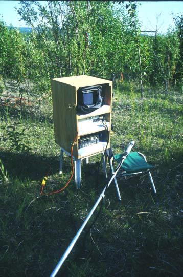
14 LAI-2000 Plant Canopy Analyzer
15 Normalized Difference Vegetation Index: an index of greenness NDVI = (NIR-R)/(NIR+R) NIR = spectral reflectance in the near-infrared band ( µm), where light scattering from the canopy dominates, R = reflectance in the red, chlorophyll-absorbing portion of the spectrum (0.58 to 0.68µm).
16 Satellites measure reflectance in discreet bands or channels

17 Thematic Mapper (TM) Sensor bands on Landsat 4 and 5 satellites
18 Reflectance spectra for typical components of the Earth s surface From Lillisand and Kiefer 1987
19 Different vegetation types have different reflectance spectra
20 Vegetation indices Vegetation indices are based on the principle that red, R, wavelengths (near 0.6µm) are absorbed by chloroplasts and mesophyll, while near infrared, NIR, wavelengths ( µm) are reflected. If the NIR reflectance is much larger than the red reflectance, then presumably there is a considerable amount of green vegetation present Satellites measure spectral reflectance in discrete bands for each picture element (pixel) in the image. For satellites monitoring the visible and NIR portions of the spectrum. Vegetation indices can thus be calculated for each pixel. In general, for many ecosystems, the vegetation indices are proportional to IPAR (intercepted phytosynthetically active radiation) and to LAI and biomass.
21 Landsat Multi-spectral sensor (MSS) From Lillisand and Kiefer 1987

22 Hand-held radiometer for ground-level measurement of spectral reflectance
 Leaf Area Index vs. Total Summer Warmth Leaf Area Index (LAI) MAT MNT 2.5 2 y = 0.4763e 0.")
23 Biomass and LAI vs. total summer warmth index Above-ground biomass vs. Total summer warmth y = e x R 2 = Barrow Biomass Atqasuk Oumalik Ivotuk Oumalik Ivotuk Total Summer Warmth ( o C) Leaf Area Index vs. Total Summer Warmth Leaf Area Index (LAI) MAT MNT y = e x R 2 = Ivotuk MAT MNT 1.5 Oumalik Barrow Atqasuk Ivotuk Oumalik Total Summer Warmth ( o C)
24 NDVI vs. total aboveground biomass NDVI vs. Total Biomass y = x R 2 = Oumalik Ivotuk Barrow 0.35 Atqasuk TotalBiomass (g/m 2 )

25 Biomass map of the Toolik Lake region derived from SPOT NDVI values From Shippert et al. 1995
26 AVHRR false-cir mosaic

27 MaxNDVI map of the circumpolar Arctic MaxNDVI < >0.62
28 NPP and biomass in the major ecosystems
29 Total above- and belowground carbon in major ecosystems
30 Lab 4: Point Sampling methods Point Quadrat Buckner Sampler Densiometer Licor LAI-2000
Canopy Structure, and Leaf area, are fundamental features of the landscape. We can t really understand the plant-atmosphere interactions without
 Canopy Structure, and Leaf area, are fundamental features of the landscape. We can t really understand the plant-atmosphere interactions without knowing how much vegetation is on the surface. 1 Plants
JOURNAL OF GEOPHYSICAL RESEARCH, VOL. 108, NO. D2, 8169, doi: /2001jd000986, 2003
 JOURNAL OF GEOPHYSICAL RESEARCH, VOL. 108, NO. D2, 8169, doi:10.1029/2001jd000986, 2003 Phytomass, LAI, and NDVI in northern Alaska: Relationships to summer warmth, soil ph, plant functional types, and
How would you measure shrub cover here? FOR 274: Forest Measurements and Inventory. Density: What is it?
 How would you measure shrub cover here? Message of the Day: Quadrat & Line Intercept methods are used in multiple disciplines and are all essentially the same FOR 274: Forest Measurements and Inventory
Vegetation Biomass, NDVI, and LAI along the Eurasian Arctic Transect
 Vegetation Biomass, NDVI, and LAI along the Eurasian Arctic Transect Howard E. Epstein, Donald A. Walker, Gerald V. Frost, Martha K. Raynolds, and Uma S. Bhatt ICOP 216 - Potsdam, Germany (Photo H.E. Epstein)
Using Landsat TM Imagery to Estimate LAI in a Eucalyptus Plantation Rebecca A. Megown, Mike Webster, and Shayne Jacobs
 Using Landsat TM Imagery to Estimate LAI in a Eucalyptus Plantation Rebecca A. Megown, Mike Webster, and Shayne Jacobs Abstract The use of remote sensing in relation to determining parameters of the forest
Figure by Railsback, h2p:// Surface charges and adsorb4on
 Figure by Railsback, h2p://www.gly.uga.edu/railsback/fundamentals/8150goldich&bondstreng06ls.pdf Surface charges and adsorb4on Borrowed from Paul Schroeder, Uga h2p://clay.uga.edu/courses/8550/ 1 aridisol
Remote Sensing for Fire Management
 Remote Sensing for Fire Management FOR 435/535: Remote Sensing for Fire Management 5. Severity A Source of Confusion Field Measures Remote Sensing Measures FOR 435: A Source of Confusion The terms fire
Equipment. Methods. 6. Pre-treatment monitoring will take place during the growing season.
 Vegetation and Fuel Monitoring Protocols for the Long Island Pine Barrens Fire Management Demonstration Site Project Adapted from the UMass Project Managing Fuels in Northeastern Barrens Plot Selection,
Experimental Alteration of Plant Canopy and the Effects on Cryoturbation Regime
 Experimental Alteration of Plant Canopy and the Effects on Cryoturbation Regime Anja Kade, Donald Walker Institute of Arctic Biology University of Alaska Fairbanks Frost Boils in Alaskan Arctic Tundra
In this presentation we are going to talk about monitoring, measuring and the quantification of carbon stocks in tropical peatland forests.
 In this presentation we are going to talk about monitoring, measuring and the quantification of carbon stocks in tropical peatland forests. 1 By way of introduction, we will see why we care about peatlands,
Biotic controls over spectral reflectance of arctic tundra vegetation
 International Journal of Remote Sensing Vol. 26, No. 11, 10 June 2005, 2391 2405 Biotic controls over spectral reflectance of arctic tundra vegetation S. M. RIEDEL{, H. E. EPSTEIN*{ and D. A. WALKER{ {Department
MULTI-ANGULAR SATELLITE REMOTE SENSING AND FOREST INVENTORY DATA FOR CARBON STOCK AND SINK CAPACITY IN THE EASTERN UNITED STATES FOREST ECOSYSTEMS
 MULTI-ANGULAR SATELLITE REMOTE SENSING AND FOREST INVENTORY DATA FOR CARBON STOCK AND SINK CAPACITY IN THE EASTERN UNITED STATES FOREST ECOSYSTEMS X. Liu, M. Kafatos, R. B. Gomez, H. Wolf Center for Earth
Vegetation biomass, leaf area index, and NDVI patterns and relationships along two latitudinal transects in arctic tundra
 Vegetation biomass, leaf area index, and NDVI patterns and relationships along two latitudinal transects in arctic tundra H.E. Epstein 1, D.A. Walker 2, M.K. Raynolds 2, A.M. Kelley 3, G.J. Jia 4, C.L.
Remote Sensing (C) Team Name: Student Name(s):
 Team Name: Student Name(s):") Team Name: Student Name(s): Remote Sensing (C) Nebraska Science Olympiad Regional Competition Henry Doorly Zoo Saturday, February 27 th 2010 96 points total Please answer all questions with complete sentences
Team Name: Student Name(s): Remote Sensing (C) Nebraska Science Olympiad Regional Competition Henry Doorly Zoo Saturday, February 27 th 2010 96 points total Please answer all questions with complete sentences
Biometry Protocol. Welcome Introduction Protocols. Learning Activities Appendix. Purpose. Overview. Student Outcomes. Level. Time.
 Biometry Protocol Purpose To measure and classify the plant life present at a Land Cover Sample Site to help determine the MUC classification. Overview Students walk the half-diagonals of their Land Cover
2007 Expedition to Yamal Peninsula Region, Russia
 2007 Expedition to Yamal Peninsula Region, Russia Donald A. Walker, Howard E. Epstein, Elina Kaarlejärvi, Patrick Kuss, Marina O. Leibman, Nataliya G. Moskalenko, George V. Matyshak Locations Nadym Laborovaya
Narration: In this presentation you will learn about the methods available for measuring and
 1 Narration: In this presentation you will learn about the methods available for measuring and monitoring forest carbon pools in the field. You will learn about indirect methods for aboveground tree biomass,
Greening and Seasonality: Multi-scale Approaches
 Greening and Seasonality: Multi-scale Approaches Jiong Jia Chinese Academy of Sciences jiong@tea.ac.cn Yonghong Hu Hesong Wang Howie Epstein Skip Walker Rovaniemi, March 8, 2010 Available Data NOAA/AVHRR
CROP STATE MONITORING USING SATELLITE REMOTE SENSING IN ROMANIA
 CROP STATE MONITORING USING SATELLITE REMOTE SENSING IN ROMANIA Dr. Gheorghe Stancalie National Meteorological Administration Bucharest, Romania Content Introduction Earth Observation (EO) data Drought
Effects of Land Use On Climate and Water Resources: Application of a Land Surface Model for Land Use Management
 Effects of Land Use On Climate and Water Resources: Application of a Land Surface Model for Land Use Management Gordon Bonan, PI National Center for Atmospheric Research Boulder, Colorado Personnel Supported:
Remote sensing as a tool to detect and quantify vegetation properties in tropical forest-savanna transitions Edward Mitchard (University of Edinburgh)
") Remote sensing as a tool to detect and quantify vegetation properties in tropical forest-savanna transitions Edward Mitchard (University of Edinburgh) Presentation to Geography EUBAP 10 th Oct 2008 Supervisor:
Remote sensing as a tool to detect and quantify vegetation properties in tropical forest-savanna transitions Edward Mitchard (University of Edinburgh) Presentation to Geography EUBAP 10 th Oct 2008 Supervisor:
Afforestation/Reforestation Afforestation/Reforestation Clean Development Mechanism Projects in Uttar Pradesh State August
 Afforestation/Reforestation Clean Development Mechanism Projects in Uttar Pradesh State August 9, 2014 Suresh Chauhan TERI, New Delhi Presentation outlines 1. Guidelines for preparing Project Design Document
Forest change detection in boreal regions using
 Forest change detection in boreal regions using MODIS data time series Peter Potapov, Matthew C. Hansen Geographic Information Science Center of Excellence, South Dakota State University Data from the
Each point here will be imaged with airborne LiDAR and visited by crews to measure trees and their condition.
 2014 Interior Alaska Highlights: Forests of the Tanana Valley State Forest and Tetlin National Wildlife Refuge Alaska This briefing is a synopsis of a more detailed report that is being published by the
8/21/13. Outline. Feasibility of measuring individual trees using remote sensing. Introduction. Introduction -definition -usage -limitation
 Feasibility of measuring individual trees using remote sensing Mega Binti Abang PhD Candidate University of Tennessee Department of Forestry, Wildlife and Fisheries Room 160 Plant Biotech Building Wednesday
Effects of Simulated MPB on Hydrology and Post-attack Vegetation & Below-ground Dynamics
 Effects of Simulated MPB on Hydrology and Post-attack Vegetation & Below-ground Dynamics Principal investigators: Uldis Silins and Ellen Macdonald Ph.D. projects: Anne McIntosh and Pablo Piña Lead field
Quantifying CO 2 fluxes of boreal forests in Northern Eurasia
 Quantifying CO 2 fluxes of boreal forests in Northern Eurasia Integrated analyses of in-situ eddy flux tower, remote sensing and biogeochemical model Xiangming Xiao Institute for the Study of Earth, Oceans
Spectral Responses of Eucalyptus Trees Submitted to Natural Hydrocarbon Seepages: An Integrated Approach from Leaf- to Canopy- Scales
 State University of Campinas - UNICAMP Institute of Geosciences (IG) Spectral Responses of Eucalyptus Trees Submitted to Natural Hydrocarbon Seepages: An Integrated Approach from Leaf- to Canopy- Scales
Above- and Belowground Biomass and Net Primary Productivity Landscape Patterns of Mangrove Forests in the Florida Coastal Everglades
 Above- and Belowground Biomass and Net Primary Productivity Landscape Patterns of Mangrove Forests in the Florida Coastal Everglades Edward Castaneda Robert R. Twilley Victor H. Rivera-Monroy Department
VCS MODULE VMD0022 ESTIMATION OF CARBON STOCKS IN LIVING PLANT BIOMASS
 VMD0022: Version 1.0 VCS MODULE VMD0022 ESTIMATION OF CARBON STOCKS IN LIVING PLANT BIOMASS Version 1.0 16 November 2012 Document Prepared by: The Earth Partners LLC. Table of Contents 1 SOURCES... 2 2
Identifying and and Understanding Carbon Cycle Implications of of North American Natural and and Anthropogenic Disturbances:
 Identifying and and Understanding Carbon Cycle Implications of of North American Natural and and Anthropogenic Disturbances: 1982-2005 Progress Progress Report Report NRA-04-OES-01 NRA-04-OES-01 Christopher
Satellite Earth Observation
 Satellite Earth Observation Services for Ecosystem valuation Prof Nick Veck Head of the CEO s Office Satellite Applications Catapult 17 March 2017 Outline Introduction to Earth observation and ecosystem
How are these equations relevant to remotely sensed data? Source: earthsci.org/rockmin/rockmin.html
 Lecture 3 How does light give us information about environmental features Revision Select a different scoop from last week Post the key points as a reaction to http://www.scoop.it/t/env22-52-w2 (need to
Relative impact. Time
 Relative impact? Time Relative impact MPB - Unique disturbance agent Larger & older trees selectively killed but remain standing (vs logging) needles can remain 3-5 yrs+ Understory & soil layers not directly
Estimates of Carbon Stock of India s forests
 Estimates of Carbon Stock of India s forests GOFC-GOLD Symposium 15-19 April 2013 Wageningen University, Netherlands Devendra PANDEY Consultant/ Fmr DG, Forest Survey of India Email ID: dpandeyifs@rediffmail.com;
INPA S APPROACH TO ESTIMATE CHANGES IN CARBON STOCKS AND RELATED UNCERTAINTIES
 INPA S APPROACH TO ESTIMATE CHANGES IN CARBON STOCKS AND RELATED UNCERTAINTIES by Niro Higuchi INPA Nat l Institute for Research in the Amazon FRA 2005 BIOMASS CATEGORIES Above-ground biomass: All living
Using Imagery and LiDAR for cost effective mapping and analysis for timber and biomass inventories
 Using Imagery and LiDAR for cost effective mapping and analysis for timber and biomass inventories Mark Meade: CTO Photo Science Mark Milligan: President LandMark Systems May 2011 Presentation Outline
Temporal Relationship Between Landsat 8 Spectral Reflectance and Transparency in Grand Lake O' the Cherokee
 Temporal Relationship Between Landsat 8 Spectral Reflectance and Transparency in Grand Lake O' the Cherokee 37 TH Annual Oklahoma Governor s Water Conference October 11 th 12 th, 2016 Norman, Oklahoma
LIVING PLANT BIOMASS
 Proposed VCS Module/Tool LIVING PLANT BIOMASS Document Prepared by: The Earth Partners LLC. Title Living Plant Biomass Version 1.0 Date of Issue 19-9-2011 Type Module Sectoral Scope AFOLU Prepared By Contact
Integration of forest inventories with remotely sensed data for biomass mapping: First results for tropical Africa
 Integration of forest inventories with remotely sensed data for biomass mapping: First results for tropical Africa Alessandro Baccini Nadine Laporte Scott J. Goetz Mindy Sun Wayne Walker Jared Stabach
Investigating ecological patterns and processes in tropical forests using GIS and remote sensing
 Investigating ecological patterns and processes in tropical forests using GIS and remote sensing Carlos Portillo-Quintero Center for Earth Observation Sciences (CEOS) Department of Earth & Atmospheric
Role and importance of Satellite data in the implementation of the COMIFAC Convergence Plan
 Plenary Meeting of the Congo Basin Forest Partnership (CBFP) Palais des Congrès, Yaoundé. Cameroon 11-12 November, 2009 Role and importance of Satellite data in the implementation of the COMIFAC Convergence
TOARC Research Progress Report Field Season #2 Completed Date: December 10 th, 2011
 Tallgrass Prairie Restoration within Abandoned Sand Pits in Southern Ontario: An Investigation of Native Prairie Plant Response to Mycorrhizal Inoculation and Carbon Amendments in Post-mine Soil TOARC
Reclamation Monitoring. Rachel Mealor Extension Range Specialist Department of Renewable Resources
 Reclamation Monitoring Rachel Mealor Extension Range Specialist Department of Renewable Resources Road Map Considerations for monitoring, both preand post reclamation Reclamation site dealing with (reference
Litterfall sampling and analysis FutMon (Life+) Field Protocol IM1 recommended, mandatory on D1 and D2 Demonstration Project plots
 Field Protocol IM1 recommended, mandatory on D1 and D2 Demonstration Project plots") field_prot_litter_v1_140509.doc page 1 / 8 Contents Litterfall sampling and analysis FutMon (Life+) Field Protocol 2009 V1; last update 14 th May 2009 IM1 recommended, mandatory on D1 and D2 Demonstration
field_prot_litter_v1_140509.doc page 1 / 8 Contents Litterfall sampling and analysis FutMon (Life+) Field Protocol 2009 V1; last update 14 th May 2009 IM1 recommended, mandatory on D1 and D2 Demonstration
Remote Measurements of Active Fire Behavior and Post-Fire Effects
 Remote Measurements of Active Fire Behavior and Post-Fire Effects Alistair Smith (and many many others ) Remote Sensing: A very Brief Overview ~ 5 million years B.C. : Humans Begin to Understand their
Abstract. Key words: Diversity, Biomass, Carbon & Nutrients, RS & GIS techniques.
 ANALYSIS OF LAND USE, DIVERSITY, BIOMASS, C AND NUTRIENT STORAGE OF A DRY TROPICAL FOREST ECOSYSTEM OF INDIA USING SATELLITE REMOTE SENSING AND GIS TECHNIQUES T. Thakur 1 and S.L. Swamy.2 1 Mission Biofuels
Satellite observations of fire-induced albedo changes and the associated radiative forcing: A comparison of boreal forest and tropical savanna
 Satellite observations of fire-induced albedo changes and the associated radiative forcing: A comparison of boreal forest and tropical savanna 1 Yufang Jin, 1 James T. Randerson, 2 David P. Roy, 1 Evan
Accuracy assessment of the vegetation continuous field tree cover product using 3954 ground plots in the south-western USA
 International Journal of Remote Sensing Vol. 26, No. 12, 20 June 2005, 2699 2704 Accuracy assessment of the vegetation continuous field tree cover product using 3954 ground plots in the south-western USA
Real-time Live Fuel Moisture Retrieval with MODIS Measurements
 Real-time Live Fuel Moisture Retrieval with MODIS Measurements Xianjun Hao, John J. Qu 1 {xhao1, jqu}@gmu.edu School of Computational Science, George Mason University 4400 University Drive, Fairfax, VA
Determination of Aboveground Biomass of Wetland Macrophytes
 PARTNERSHIP FOR THE DELAWARE ESTUARY Science Group Determination of Aboveground Biomass of Wetland Macrophytes Date Prepared: 7/17/14 Prepared By: Danielle Kreeger, Ph.D. Suggested Citation: Kreeger, D.
Monitoring epidemics (continued)
") Monitoring epidemics (continued) REVIEW: Disease intensity: Disease incidence Disease severity (usual usage for area [relative area] affected by disease) Ordinal severity rating Disease count (density)
Monitoring epidemics (continued) REVIEW: Disease intensity: Disease incidence Disease severity (usual usage for area [relative area] affected by disease) Ordinal severity rating Disease count (density)
Monitoring Manual. for Grassland, Shrubland and Savanna Ecosystems. Volume I: Quick Start
 Monitoring Manual for Grassland, Shrubland and Savanna Ecosystems Volume I: Quick Start by Jeffrey E. Herrick, Justin W. Van Zee, Kris M. Havstad, Laura M. Burkett and Walter G. Whitford with contributions
Forest Biomass Estimation, Australia
 Forest Biomass Estimation, Australia 1 Richard Lucas, 2 John Armston, 1 Peter Bunting, 1 Daniel Clewley, 2 Peter Scarth, 2 Michael Schmidt, 2 Arnon Accad, 3 Paul Siqueira and 3 Yang Lei 1 Institute of
Landsat 5 & 7 Band Combinations
 Landsat 5 & 7 Band Combinations By James W. Quinn Landsat 5 (TM sensor) Wavelength (micrometers) Resolution (meters) Band 1 0.45-0.52 30 Band 2 0.52-0.60
FOREST COVER MAPPING AND GROWING STOCK ESTIMATION OF INDIA S FORESTS
 FOREST COVER MAPPING AND GROWING STOCK ESTIMATION OF INDIA S FORESTS GOFC-GOLD Workshop On Reducing Emissions from Deforestations 17-19 April 2007 in Santa Cruz, Bolivia Devendra PANDEY Forest Survey of
Supporting Online Material for
 www.sciencemag.org/cgi/content/full/318/5853/1107/dc1 Supporting Online Material for Hurricane Katrina s Carbon Footprint on U.S. Gulf Coast Forests Jeffrey Q. Chambers,* Jeremy I. Fisher, Hongcheng Zeng,
Lesson 3.1. Canada's Biomes. As you go down the list, the terms include more and more biotic and abiotic factors. 3.1 Canada's Biomes.
 Lesson 3.1 Canada's Biomes Jun 4 7:26 PM As you go down the list, the terms include more and more biotic and abiotic factors. May 17 2:04 PM 1 Biome a large geographic area with a similar climate Biosphere
AGOG 485/585 APLN 533 Spring 2019
 AGOG 485/585 APLN 533 Spring 2019 Outline Vegetation analysis and related MODIS products Phenology and productivity Fire monitoring using MODIS and VIIRS data Readings: Textbook Chapter 17 FAQ on Vegetation
Forest Change Caused by Wind, Water, Ice, Fire, Insects/Disease & Harvesting
 Forest Change Caused by Wind, Water, Ice, Fire, Insects/Disease & Harvesting Why use remote sensing for mapping forest changes? Synoptic view of damage on a forest landscape or regional level. Can stop
INFLUENCE OF FOREST STAND PARAMETERS ON VEGETATION INDICES USED FOR CONIFEROUS FOREST DAMAGE ASSESSMENT
 INFLUENCE OF FOREST STAND PARAMETERS ON VEGETATION INDICES USED FOR CONIFEROUS FOREST DAMAGE ASSESSMENT Jonas Ard6 Department of Physical Geography University of Lund S61vegatan 13 S-223 62 Lund, SWEDEN
Vegetation productivity patterns at high northern latitudes: a multi-sensor satellite data assessment
 Global Change Biology (2014), doi: 10.1111/gcb.12647 Supporting information for: Vegetation productivity patterns at high northern latitudes: a multi-sensor satellite data assessment KEVIN C. GUAY 1, PIETER
Using a Canopy Reflectance Model for the Detection of Aspen Dieback from Multi temporal Landsat Thematic Mapper Data
 PAPER ID 515 Using a Canopy Reflectance Model for the Detection of Aspen Dieback from Multi temporal Landsat Thematic Mapper Data E.J. Arsenault 1, R.J. Hall 1, E.H. (Ted) Hogg 1, M. Michaelian 1 and M.
Carbon and Water Cycles in Tropical Rainforests
 Date: 20-Jan-2018 RCYCLE: Teaching Materials Author: Bob Digby Carbon and Water Cycles in Tropical Rainforests Guidance Notes for Teachers This is one of two programmes produced by Pumpkin Interactive
Federal Ministry of Education and Research
 Editors Reinhard Lieberei 1, Helmut K. Bianchi 2, Vera Boehm 1, Christoph Reisdorff 1 1 Universität Hamburg, Institut für Angewandte Botanik, Ohnhorststr. 18, 22609 Hamburg, Germany 2 GKSS-Forschungszentrum
NORMALIZED RED-EDGE INDEX NEW REFLECTANCE INDEX FOR DIAGNOSTICS OF NITROGEN STATUS IN BARLEY
 NORMALIZED RED-EDGE INDEX NEW REFLECTANCE INDEX FOR DIAGNOSTICS OF NITROGEN STATUS IN BARLEY Novotná K. 1, 2, Rajsnerová P. 1, 2, Míša P. 3, Míša M. 4, Klem K. 1, 2 1 Department of Agrosystems and Bioclimatology,
FOR 274: Forest Measurements and Inventory. Growth and Yield: Overview. Growth and Yield: Overview
 FOR 274: Forest Measurements and Inventory Growth, Yield and Biomass Overview Growth Percentage Allometrics and Volume Modeling Growth and Yield Husch, Beers and Kershaw pp250-257, chapters 15 & 16 Growth:
Satellite Ecology initiative for ecosystem function and biodiversity analyses
 Satellite Ecology initiative for ecosystem function and biodiversity analyses Key topics: Satellite Ecology concept, networking networks, super-site, canopy phenology, mapping ecosystem functions Hiroyuki
Discussion of point sampling exercise
 Discussion of point sampling exercise Comparison of cover values from point quadrat and Buckner Sampler methods. Discussion of LAI (point frame vs. LAI- 2000). Discussion of Buckner Sampler vs. densiometer
Optical Sensing of Crop N
 Optical Sensing of Crop N Under Water-Limited Conditions Dan Long and John McCallum USDA-ARS Pendleton, Oregon In-Season N Management Applying fertilizer N based on information acquired during the growing
Institute of Water and Flood Management, Bangladesh University of Engineering and Technology, Dhaka- 1000, Bangladesh. 2
 ID: EE 024 TEMPORAL VARIATION OF BIOMASS CONCENTRATION IN THE BANGLADESH SUNDARBANS USING REMOTE SENSING TECHNIQUES Ahsan Azhar Shopan 1*, G.M. Tarekul Islam 1, A.K.M. Saiful Islam 1, Md. Munsur Rahman
SPECTRAL RESPONSE OF WATER STRESS IN QUERCUS SPP.
 SPECTRAL RESPONSE OF WATER STRESS IN QUERCUS SPP. IMPLICATIONS TOWARD EARLY DETECTION OF OAK WILT DISEASE Blake Weissling, Hongjie Xie, and Paul Jurena Laboratory of Remote Sensing and Geoinformatics Earth
Hands on R Final Project Greg Pappas
 Understory Vegetation Response to Mountain Pine Beetle-Induced Lodgepole Pine Mortality in Rocky Mountain National Park, Colorado Introduction This study characterizes the response of understory vegetation
DIFFERENCES IN ONSET OF GREENNESS: A MULTITEMPORAL ANALYSIS OF GRASS AND WHEAT IN KANSAS*
 Houts, M. E., K. P. Price, and E. A. Martinko. 2001. Differences in onset of Greenness: A multitemporal analysis of Grass and Wheat in Kansas. Proceedings, Annual Convention, American Society of Photogrammetric
Landsat imagery applications to identify vegetation recovery from acidification in mountain catchments
 DOI: 10.15201/hungeobull.64.2.3 Křeček, J. and Krčmář, V. Hungarian Geographical Bulletin 64 64 (2015) (2) 121 126. 121 126. Landsat imagery applications to identify vegetation recovery from acidification
Forest Dragon 3 Project Id
 Forest Dragon 3 Project Id. 10666 Principle Investigator: Co-Investigator: Young Scientists: Prof. Li, Academy of Forest Sciences Prof. Schmullius, University of Jena Prof. Pang, Dr. Feilong, Dr. Santoro
ГЕОЛОГИЯ МЕСТОРОЖДЕНИЙ ПОЛЕЗНЫХ ИСКОПАЕМЫХ
 LE HUNG TRINH (Le Quy Don Technical University) APPLICATION OF REMOTE SENSING TECHNIQUE TO DETECT AND MAP IRON OXIDE, CLAY MINERALS, AND FERROUS MINERALS IN THAI NGUYEN PROVINCE (VIETNAM) This article
Modelling potato growth and development with parameters derived from remotely sensed data
 Modelling potato growth and development with parameters derived from remotely sensed data Carolina Barreda 1, Carla Gavilán 1, and Roberto Quiroz 1 1 International Potato Center c.barreda@cgiar.org c.gavilan@cgiar.org
Measuring canopy nitrogen nutrition in tobacco plants using hyper spectrum parameters
 Measuring canopy nitrogen nutrition in tobacco plants using hyper spectrum parameters Yong Zou, Xiaoqing YE, et al. Shenzhen Tobacco Ind. Co., Ltd. of CNTC Layout Background Experimental Program Experimental
Classification of Forest Dominate Types Using an Integrated Landsat and Ecological Model
 Classification of Forest Dominate Types Using an Integrated Landsat and Ecological Model Southern Region Existing Vegetation Mapping Pilot Project Test Supported By Region 8 Engineering/GeoSpatial 3 Year
VCS MODULE VMD0023 ESTIMATION OF CARBON STOCKS IN THE LITTER POOL
 VMD0023: Version 1.0 VCS MODULE VMD0023 ESTIMATION OF CARBON STOCKS IN THE LITTER POOL Version 1.0 16 November 2012 Document Prepared by: The Earth Partners LLC. Table of Contents 1 SOURCES... 2 2 SUMMARY
Carbon sequestration: Forest and soil
 LG/14/12 14 th Meeting of the London Group on Environmental Accounting Canberra, 27 30 April 2009 Carbon sequestration: Forest and soil Jukka Muukkonen, Statistics Finland LG/14/12 1(4) Carbon sequestration:
Information Needs for Climate Change Policy and Management. Improving Our Measures of Forest Carbon Sequestration and Impacts on Climate
 Improving Our Measures of Forest Carbon Sequestration and Impacts on Climate Richard Birdsey Mark Twery Coeli Hoover Information Needs for Climate Change Policy and Management Good data about past trends
Forest Biomes. Chapter 9
 Forest Biomes Chapter 9 9.1 Objectives ~Describe the characteristics of the coniferous forest. ~Explain adaptations that enable organisms to survive in coniferous forests. 9.1 Coniferous Forests Coniferous
Techniques for measurement of GHG emissions:
 Techniques for measurement of GHG emissions: In situ soil and biomass sampling for carbon and nitrogen measurements Peter Koncz pkoncz@gmail.com MTA-SZIE Plant Ecology Research Group Livestock and Climate
Land Cover Change in CLM4. Dr. Peter Lawrence
 Land Cover Change in CLM4 Dr. Peter Lawrence Project Scientist Terrestrial Science Section Climate and Global Dynamics Division (With thanks to TSS group for their many contributions) Slide 1 - Title Land
New Transient Land Surface Data Sets for CLM5
 New Transient Land Surface Data Sets for CLM5 Dr. Peter Lawrence Project Scientist NCAR Terrestrial Science Section David Lawrence, George Hurtt and many others Slide 1 - Title 1. CLM4 CMIP5 Land Surface
A Remote Sensing Based System for Monitoring Reclamation in Well and Mine Sites
 A Remote Sensing Based System for Monitoring Reclamation in Well and Mine Sites Nadia Rochdi (1), J. Zhang (1), K. Staenz (1), X. Yang (1), B. James (1), D. Rolfson (1), S. Patterson (2), and B. Purdy
Developing spatial information database for the targeted areas
 Developing spatial information database for the targeted areas 1 Table of Contents Jericho and Al- Auja (Palestine) 1 Background... 3 2 Monitoring the plant biomass using NDVI in Jericho and Al Auja...
Mapping and Assessing Tree Island Fire Damage and Recovery within the Short-Hydroperiod Marl Prairie Grasslands of the Everglades
 Mapping and Assessing Tree Island Fire Damage and Recovery within the Short-Hydroperiod Marl Prairie Grasslands of the Everglades Pablo L Ruiz Adam A Spitzig Jay P Sah Michael S Ross ENP Cooperative Agreement
Integral Methods of Environmental Assessment at Mining Regions Based on Remote Sensing Data
 Integral Methods of Environmental Assessment at Mining Regions Based on Remote Sensing Data Giniyatullina O.L., Potapov V.P., Schactlivtcev E.L. Institute of Computational Technologies Siberian Branch
Integrating remote-, close range- and in-situ sensing for highfrequency observation of crop status to support precision agriculture
 Sensing a Changing World 2012 Integrating remote-, close range- and in-situ sensing for highfrequency observation of crop status to support precision agriculture Lammert Kooistra 1 *, Eskender Beza 1,
Quantifying the role of urban ecosystems on terrestrial carbon cycling
 Quantifying the role of urban ecosystems on terrestrial carbon cycling Cristina Milesi Cal State Univ Monterey Bay - NASA Ames Research Center Land transformed by urbanization is often the most fertile
MULTI-SOURCE SPECTRAL APPROACH FOR EARLY WATER-STRESS DETECTION IN ACTUAL FIELD IRRIGATED CROPS
 Department of Geography and Environmental Studies MULTI-SOURCE SPECTRAL APPROACH FOR EARLY WATER-STRESS DETECTION IN ACTUAL FIELD IRRIGATED CROPS Maria Polinova 1, Thomas Jarmer 2, Anna Brook 1 1 Spectroscopy
Biocomplexity of Arctic Patterned Ground: ecosystems
 Biocomplexity of Arctic Patterned Ground: ecosystems A tale of cracking, heaving, and smothering Photos: Ina Timling and D.A. Walker Biocomplexity of Arctic Patterned Ground: ecosystems A tale of cracking,
Presentation plan General aims, approaches and tools Our approaches to zoning and classification of vegetation at hierarchical levels General backgrou
 Presentation plan General aims, approaches and tools Our approaches to zoning and classification of vegetation at hierarchical levels General background on status of ecological regionalization and mapping
Carbon stores in tree & understorey roots - relationships to site, stand and climate factors Helmisaari, H-S., Derome, J., Kukkola, M. & Nöjd, P.
 Carbon stores in tree & understorey roots - relationships to site, stand and climate factors Helmisaari, H-S., Derome, J., Kukkola, M. & Nöjd, P. Carbon stores and fluxes in forest ecosystems Deposition
Slide 1. Earth Science. Chapter 11 Living Systems
 Slide 1 Earth Science Chapter 11 Living Systems Slide 2 Biomes A biome is a region with a certain climate and certain forms of vegetation. It is mostly the climate temperature and precipitation in an area
Forestry Applications of LiDAR Data Funded by the Minnesota Environment and Natural Resources Trust Fund
 Conservation Applications of LiDAR Data Workshops funded by the Minnesota Environment and Natural Resources Trust Fund Conservation Applications of LiDAR Data Workshops funded by: Minnesota Environment
Image Classification I
 Image Classification I Classification is the process of labeling image pixels using predetermined categorical classes. Components: Image features Classification scheme Signatures Training Classifiers Classification