Classification of Forest Dominate Types Using an Integrated Landsat and Ecological Model
|
|
|
- Moris Tyler Pitts
- 6 years ago
- Views:
Transcription

1 Classification of Forest Dominate Types Using an Integrated Landsat and Ecological Model Southern Region Existing Vegetation Mapping Pilot Project Test Supported By Region 8 Engineering/GeoSpatial 3 Year Effort
2 Southern Region Existing Vegetation Mapping Pilot Project Test Background of the Pilot Test Purpose and Goals of the Pilot Test Vegetation & Mapping Guide Method Results Discussion
3 Principal Cooperators Nantahala Forest Steven Simon, USDA-FS Ecologist Botanist Henry McNab, USDA-FS Research Forester Regional Office Renee Jacokes, USDA-FS Remote Sensing Specialist Washington Office Ron Brohman, USDA-FS WO Contact RSAC Ken Brewer, IAAA Program Leader John Gillham, Image Analyst Jess Clark, Image Analyst

4 Background Existing Vegetation Classification and Mapping Technical Guide The Northern Region Vegetation Mapping Project, R1-VMP Northern Idaho & NW Montana (Region 1) Vegetation Classification & Mapping Landsat Imagery & ecognition Software Completed in April 2004 Is the method applied by the R1-VMP and the Existing Vegetation Classification and Mapping Technical Guide applicable to the Southern Region?
5 Existing Vegetation Mid-level Mapping Standards Southern Region Pilot Test Project Objectives Provide an objective evaluation of the Draft Existing Vegetation Mid-level Mapping protocol and standards. Develop and demonstrate a process for mid-level existing vegetation mapping suitable application in the hardwood dominated forests of the Southern Region. Provide a mid-level existing vegetation map for the Nantahala National Forest to support the Forests, inventory, monitoring and Forest planning activities that will facilitate maintenance through change detection.


6 Investigator Concerns 1. Capability to map floristic and diameter classes in deciduous forests 2. Suitability of TM imagery to meet standards and field requirements 3. Can the Vegetation Guide be applied to the Southern Region
7 Existing Vegetation Classification and Mapping Technical Guide to the Mid-level Standards NVC Physiognomic Sub-class Total Vegetative Cover Total Tree Canopy Cover Overstory Tree Diameter Floristic Map Classes Minimum Map Feature Map Accuracy Goals 80% to 90% Map Accuracy Standard 65%
8 Existing Vegetation Mapping Physiognomic Classification Division Order Class Subclass Nonvegetated Vegetated No Dominant Lifeform Tree Dominated Shrub Dominated Herb-Nonvascular Dominated Sparse Vegetation Closed Tree Canopy Open Tree Canopy Shrubland Dwarf Shrubland Herbaceous Vegetation Nonvascular Vegetation Consolidated Rock sparse Vegetation Bolder Gravel Cobble sparse Vegetation Unconsolidated Sparse Vegetation Evergreen Closed Tree Canopy Deciduous Closed Tree Canopy Mixed Evergreen-Deciduous Closed Tree Canopy Evergreen Open Tree Canopy Deciduous Open Tree Canopy Mixed Evergreen-Deciduous Open Tree Canopy Evergreen Shrubland Deciduous Shrubland Mixed Evergreen/Deciduous Shrubland Evergreen Dwarf Shrubland Deciduous Dwarf Shrubland Mixed Dwarf Evergreen/Deciduous Shrubland Hydromorphic Rooted Vegetation Perennial Graminoid Vegetation Perrenial forb Vegetation Annaual Graminoid or Forb Vegetation Bryophyte Vegetation Lichen Vegetation Alga Vegetation
9 Existing Vegetation Map Feature Attributes NVC Physiognomic Classification to Class (Sub-class for Woody Vegetation) Total Vegetative Cover Tree Canopy Closure Floristic Description Overstory Tree Diameter Class Floristic Classification Category SAF/SRM Cover Type Dominance Type (Locally Defined) Alliance Association Mid-level R O O O Mid-level Map Units Overstory Tree Diameter Map Units 0 to 4.9 inches DBH 5 to 9.9 inches DBH 10 to 19.9 inches DBH 20 to 29.9 inches DBH 30+ inches DBH Total Vegetation Cover Map Units Total Tree Canopy Closure Map Units 0 to 9.9% 0 to 9.9% 10 to 29.9% 10 to 29.9% 30 to 59.9% 30 to 59.9% 60 to 79.9% 60 to 79.9% 80 to 100% 80 to 100%
10 What is Mid-level? Mapping Level/Units Smaller Resolution Larger Area Mapped National-Level (National) National Strategic Inventory Broad-Level (Regional) Bioregional Planning Mid-Level (Multi-Forest) Ecosystem Assessment by Watershed Base-Level (Forest) Project Planning, Monitoring and Evaluation Higher Resolution and Smaller Area Mapped
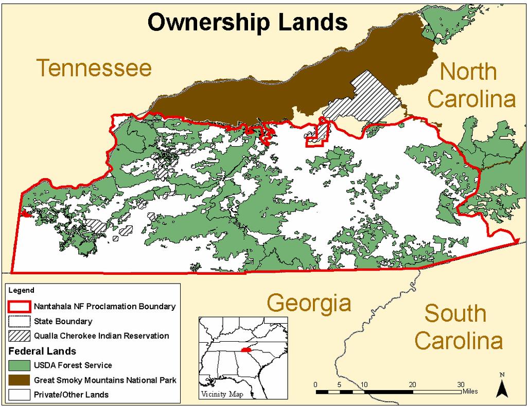
11 Nantahala National Forest Western North Carolina 35.5 N 83.5 W Elevation 1,000 to 6,600 Feet Central Appalachian Broadleaf-Coniferous Forest Meadow Province Blue Ridge Mountain Section Southern Blue Ridge Mountain Subsection Metasedimentary Mountains Subsection

12 Study Area: 1,672,675 Acres
13


14 Vegetation Classification & Mapping Processes Terrain Derived Vegetation Distribution Model (Ecological Zones) ecognition Primary Data Sets Landsat TM ETM+ data Ecological Zones Based on Terrain Models Image Processing Lecia Imagine Analysis ecognition Software for Existing Vegetation Mid-level Mapping ArcGRID
 June (Path 18) 2003 / September (Path 19) 2002 Scene Path 19/Row 35 Scene Path 19/Row 36 Scene Path 18/Row")
15 Transition ETM+ (Landsat 7) April 2000 Leaf-off ETM+ (Landsat 7) October (Path 18) 2001/ December (Path 19) 2001 Leaf-on TM5 (Landsat 5) June (Path 18) 2003 / September (Path 19) 2002 Scene Path 19/Row 35 Scene Path 19/Row 36 Scene Path 18/Row 36
16 Ecological Zones of the Southern Appalachians Ecological Zone Units of land delineating the environment that support a specific plant community Initial modeling for the 5.6 million acre Southern Appalachians was based on the SAVD data set collected between 1976 and 1999 by 20 investigators Plots were located in undisturbed stands > 50 years Terrain variables for the initial models were based on 30 meter DEM s The investigators developing the initial model were: Steve Simon USDA-FS Ecologist Botanist Thomas Collins USDA-FS Geologist Gary Kaufman USDA-FS Botanist Henry McNab USDA-FS Research Forester Chris Ulrey USDI-NPS Vegetation Specialist Southern Appalachian Ecological Zones Forest Vegetation Distribution Model
17 Second Approximation Ecological Zones Terrain Models are reprocessed with 15 meter DEM s Area in and around the Nantahala National Forest The Primary Investigators is Steve Simon USDA-FS Ecologist Botanist Ecological Zone Units of land delineating the environment that support a specific plant community Ecological Zones Forest Vegetation Distribution Model
18 Ecological Zones Dominance Type There are 17 Ecological Zones in the Nantahala Study Area 32 Floristic Classes, referred to a Forest Dominance Types Were classified based on the integration of 15 Ecological Zones Mesic Oak-Hickory Rich Cove Acidic Cove Pine-Oak Heath High Elevation Red Oak Shortleaf Pine-Oak Northern Hardwood Cove Northern Hardwood Slope Oak/Rhododendron Dry-Mesic Oak Hickory Alluvial Forest Chestnut Oak/Mt. Laurel Spruce-Fir Shortleaf Pine-Oak Heath Dry Oak
19 ecognition Software - Image Segmentation

20 ecognition Software - Hierarchical Structure
21 Reference Data - Preprocessing Precipitation (annual average, January, April, July, October) Temperature (annual average, January, April, July, October) Elevation (meters from a 10m DEM)) Slope (in percent slope) Aspect Trishade (hybrid hillshade/aspect layer 3 bands) Landsat 7 ETM+ (bands 1-6 and panchromatic/ms merge for segmentation) 3 temporal dates (east half = , , ; west half = , , ) NDVI Normalized Difference Vegetation Index -- for all ETM + dates. PCA Principle Components Analysis (1st 3 bands) -- for all ETM+ dates Tassel Cap (TCAP) brightness, greenness, and wetness bands -- for all ETM+ dates Texture spectral variability from DOQs (3x3 low-pass filter done at 3m) Tone spectral tone from DOQs TNT Texture/Tone ratio Ecological Zones
22 ecognition Software - Dominance Type There are 11 Forest Dominance Types Tulip poplar Oak Spruce-fir Hemlock White pine Hemlock-white pine Yellow pine Mixed evergreen-deciduous tree Deciduous tree/evergreen shrub Mixed evergreen-deciduous tree/evergreen shrub Mixed deciduous tree.
 that occurred within an Ecological Zone (Shortleaf Pine, Mesic Oak-Hickory) and not the reverse. ecological matches, ecological mismatches, and ecognition defined types.")
23 Integration of Ecological & ecognition Models The class are compare using ArcGrid Classes defined by ecognition were evaluated within the context of Ecological Zones i.e., we summarized the different ecognition classes (Pine, Oak, White Pine, etc.) that occurred within an Ecological Zone (Shortleaf Pine, Mesic Oak-Hickory) and not the reverse. ecological matches, ecological mismatches, and ecognition defined types. existing vegetation types defined by ecognition that always took precedence over Ecological Zones included water, agricultural fields, native-grass-shrub, and rock outcrops ArcGRID

24 Accuracy Assessment A total of 330 accuracy assessment polygons on land administered by the U.S. Forest Service An equal number of accuracy samples, i.e. 10 samples, were randomly distributed across the 32 taxa Least 2% of the study area acres were assessed Random selection method was used Good distribution of samples in all polygon sizes that were well-distributed throughout the study area.
25 Method Canopy Cover Used ecognation to process the Canopy Cover based on the Vegatation Guide for Mid-Scale: 0-9.9% %, % % Canopy Cover for the Field Study was analyzed based on > 66%, 33-66%, and <33%. The overall canopy cover accuracy was 75.3%.
26 Results The overall accuracy of the mapping at the physiognomic subclass level was 92%. The overall accuracy at the forest dominance type level, an integration of image processing and ecological models, was 42%. The overall accuracy for tree canopy closure was 75%. The overall accuracy of Ecological Systems, a mid-level map product useful for Forest Planning, was 70%.
27 Discussion The Southern Region will incorporate the classifications and guidelines provided by the Technical Guide. The combination of ecognition and ecological vegetation modeling provided more accurate classification of existing vegetation than traditional automated processes. ecognition classification of rare vegetation types was poor while the environmental modeling of rare types was good. ecognition did well in mapping common types such as White Pine (about 60% accurate). Ecological vegetation modeling provides more accurate classification of larger areas of vegetation and non-vegetation types. As the Forest Service experiences decreasing budget and increasing need to map vegetation, ecological and ecognition models will provide an important cost saving benefit for the Agency.
28 Questions
Nantahala Pisgah NF Plan Process - Natural Range of Variation. Gary Kauffman National Forests in NC Ecologist
 Nantahala Pisgah NF Plan Process - Natural Range of Variation Gary Kauffman National Forests in NC Ecologist 1 NRV Plan Directives indicate must contain plan components, including standards or guidelines,
Cooper Creek ECS Ecological Departure Analysis
 Cooper Creek ECS Ecological Analysis Methods: - LIDAR derived Canopy height and canopy density data obtained from Luis Miguel Verissimo of Michigan Tech university - LIDAR derived Canopy Height/Density
Natural Resources Inventories
 Natural Resources Inventories A Fundamental Requirement for Managing Corps Lands Stewardship Advisory Team Objectives Gain a better understanding of the development of a level one inventory Inventory Relationship
Summary of 2012 Fire Effects Monitoring for the Southern Blue Ridge Fire Learning Network 1. Peter Bates 2 December 21, 2012
 Summary of 212 Fire Effects Monitoring for the Southern Blue Ridge Fire Learning Network 1 Peter Bates 2 December 21, 212 Introduction: Forest Stewards, Inc. entered into a contract with The Nature Conservancy
A Remote Sensing Based Urban Tree Inventory for the Mississippi State University Campus
 A Remote Sensing Based Urban Tree Inventory for the Mississippi State University Campus W. H. Cooke III a and S.G. Lambert b a Geosciences Department, GeoResources Institute, Mississippi State University,
Production of the Missouri Land Cover Data Layer Brief Notes 1/00 DRAFT
 Production of the Missouri Land Cover Data Layer Brief Notes 1/00 DRAFT This land cover data layer was derived from Thematic Mapper (TM) satellite data from 1991, 1992, and 1993 (listed below). For most
Assessment of Landscape Scale Forest Structure and Ecological Departure in Western North Carolina Josh Kelly
 Assessment of Landscape Scale Forest Structure and Ecological Departure in Western North Carolina Josh Kelly Outline of Presentation Overview of Maps, Models, and Metrics ecap methodology sensu Low et
EOSD Land Cover Classification Legend Report
 EOSD Land Cover Classification Legend Report January 13, 2003 Version 2 Mike Wulder Canadian Forest Service Natural Resources Canada Victoria, British Columbia Trisalyn Nelson TNT Geoservices Victoria,
Mapping forest structure along the southern Blue Ridge Parkway from LiDAR
 Mapping forest structure along the southern Blue Ridge Parkway from LiDAR Steven P Norman (US Forest Service) Jitendra Kumar (Oak Ridge National Lab.) William W Hargrove (US Forest Service) Forrest Hoffman
Assessment of Land Use Change in the Coterminous. Organization of the United Nations
 Assessment of Land Use Change in the Coterminous United States and Alaska for Global Assessment of Forest Loss Conducted by the Food and Agricultural Organization of the United Nations Tanushree Biswas,
The Washington Hardwoods Commission. Presents: A Hardwood Resource Assessment for Western Washington
 The Washington Hardwoods Commission Presents: A Hardwood Resource Assessment for Western Washington June, 2002 Abstract This project used Landsat TM images for mapping current forest distribution across
Forest Resources of the Black Hills National Forest
 United States Department of Agriculture Forest Service Rocky Mountain Research Station August 22 Forest Resources of the Black Hills National Forest Larry T. DeBlander About the author Larry T. DeBlander
Ecological Zone mapping in the South Mountains and New River Headwaters Landscapes
 Ecological Zone mapping in the South Mountains and New River Headwaters Landscapes by Steve Simon Excerpted as-is from a report to the Southern Blue Ridge Fire Learning Network Landscape EVALUATING FIRE
Chapter 6. Developing the LANDFIRE Vegetation and Biophysical Settings Map Unit Classifications for the LANDFIRE Prototype Project
 Chapter 6 Developing the LANDFIRE Vegetation and Biophysical Settings Map Unit Classifications for the LANDFIRE Prototype Project Jennifer L. Long, Melanie Miller, James P. Menakis, and Robert E. Keane
Simulating Regeneration Dynamics in Upland Oak Stands
 Simulating Regeneration Dynamics in Upland Oak Stands Powered By Powered by: USDA Forest Service Southern Research Station Dr. David Loftis Powered By Powered by: Regen for Excel is a simulation model
An Assessment of Potential Active Restoration in Departed Forest Ecosystems. Marissa Ponder 3/31/2014
 Restoration Needs Analysis in Nantahala and Pisgah National Forests An Assessment of Potential Active Restoration in Departed Forest Ecosystems Marissa Ponder marissa.ponder@gmail.com 3/31/2014 ABSTRACT
Using Imagery and LiDAR for cost effective mapping and analysis for timber and biomass inventories
 Using Imagery and LiDAR for cost effective mapping and analysis for timber and biomass inventories Mark Meade: CTO Photo Science Mark Milligan: President LandMark Systems May 2011 Presentation Outline
Forest Change Caused by Wind, Water, Ice, Fire, Insects/Disease & Harvesting
 Forest Change Caused by Wind, Water, Ice, Fire, Insects/Disease & Harvesting Why use remote sensing for mapping forest changes? Synoptic view of damage on a forest landscape or regional level. Can stop
A Remote Sensing Based System for Monitoring Reclamation in Well and Mine Sites
 A Remote Sensing Based System for Monitoring Reclamation in Well and Mine Sites Nadia Rochdi (1), J. Zhang (1), K. Staenz (1), X. Yang (1), B. James (1), D. Rolfson (1), S. Patterson (2), and B. Purdy
Transactions. American Geophysical Union Volume 28, Number 1 February 1947
 Transactions. American Geophysical Union Volume 28, Number 1 February 1947 EFFECT OF REMOVAL OF STREAM-BANK VEGETATION UPON WATER YIELD Earl G. Dunford and P. W. Fletcher Abstract--This is a preliminary
Ecological Zones on the George Washington National Forest First Approximation Mapping
 January 2011 Ecological Zones on the George Washington National Forest First Approximation Mapping Simon, Steven A. Acknowledgements Funding provided by Challenge Cost-Share Agreement 07-CS-11080821 between
Supplement of Daily burned area and carbon emissions from boreal fires in Alaska
 Supplement of Biogeosciences, 12, 3579 3601, 2015 http://www.biogeosciences.net/12/3579/2015/ doi:10.5194/bg-12-3579-2015-supplement Author(s) 2015. CC Attribution 3.0 License. Supplement of Daily burned
Range Capability Process on Strawberry Peak Allotment
 Range Capability Process on Strawberry Peak Allotment Capability on the Ashley National Forest was largely determined for the current 1986 Forest Plan and beginning around the 1960s using a data collection
Open File Report Ext
 Open File Report Ext 2012-2 How to use Nova Scotia s new Forest Ecosystem Classification manual to identify vegetation types, and use this information to help manage your forested land. In this presentation
EFFECTS OF WILDFIRES AND LIMING OF PINE-OAK-HEATH COMMUNITIES IN THE LINVILLE GORGE WILDERNESS, WESTERN NORTH CAROLINA
 EFFECTS OF WILDFIRES AND LIMING OF PINE-OAK-HEATH COMMUNITIES IN THE LINVILLE GORGE WILDERNESS, WESTERN NORTH CAROLINA Katherine J. Elliott, James M. Vose, Jennifer D. Knoepp, and William Jackson Research
Forest Assessments with LiDAR: from Research to Operational Programs
 Forest Assessments with LiDAR: from Research to Operational Programs David L. Evans Department of Forestry Forest and Wildlife Research Center Mississippi State University Forest Remote Sensing: Then and
Evaluation of proposed ski lease area expansion on Mt. Sunapee 11/23/2004
 New Hampshire Natural Heritage Bureau DRED Division of Forests & Lands PO Box 1856 172 Pembroke Road, Concord, NH 03302-1856 (603) 271-3623 visit our web site at www.dred.state.nh.us/forlands/formgt/nhiweb
Forest Resources of the United States, 2017:
 Forest Resources of the United States, 2017: A Technical Document Supporting the Forest Service 2020 update of the RPA Assessment Abstract Oswalt, Sonja N.; Miles, Patrick D.; Pugh, Scott A.; Smith, W.
The Use of Remotely-Sensed Imagery to Analyze Vegetation Cover in Pinyon and Juniper Woodlands
 The Use of Remotely-Sensed Imagery to Analyze Vegetation Cover in Pinyon and Juniper Woodlands April Hulet, Bruce A. Roundy, Steven L. Petersen, Ryan R. Jensen, and Stephen C. Bunting Land managers in
Rapid Assessment Reference Condition Model
 R0ms Rapid Assessment Reference Condition Model The Rapid Assessment is a component of the LANDFIRE project. Reference condition models for the Rapid Assessment were created through a series of expert
Fontana Project Scoping Record August 2013
 Fontana Project Scoping Record August 2013 The Cheoah Ranger District, Nantahala National Forest, is conducting an interdisciplinary analysis of a proposed project, called the Fontana Project, in Graham
Landscape-Scale Postfire Vegetative Condition Monitoring Using Multi- temporal Landsat Imagery on the Cerro Grande Fire
 Landscape-Scale Postfire Vegetative Condition Monitoring Using Multi- temporal Landsat Imagery on the Cerro Grande Fire RS 2006 : April 27, 2006 Salt Lake City, UT Jess T. Clark Remote Sensing Applications
Variable Method Source
 Appendix S1 Appendix S1: Table S1 Plot variables Variable Method Source COVERS % shrub cover ocular estimate of shrub cover % forb cover ocular estimate of forbs % coarse woody debris % live overhead canopy
Ecomath for the North Zone of Cherokee National Forest: A Randomized Approach to Determining Forest-Wide Fire Priorities Based on Ecological Factors
 Ecomath for the North Zone of Cherokee National Forest: A Randomized Approach to Determining Forest-Wide Fire Priorities Based on Ecological Factors Josh Kelly, Public Lands Biologist MountainTrue josh@mountaintrue.org
8) Which of the following species is best adapted to poorly drained sites? a) Bur oak b) Eastern red cedar c) Black ash d) Yellow birch
 Which of the following species is best adapted to poorly drained sites? a) Bur oak b) Eastern red cedar c) Black ash d) Yellow birch") School Score Wisconsin Envirothon 2004 Forestry Exam Answer the following questions based on the species description and graphic to the right. 1) This tree is the state tree of Wisconsin and is prized
School Score Wisconsin Envirothon 2004 Forestry Exam Answer the following questions based on the species description and graphic to the right. 1) This tree is the state tree of Wisconsin and is prized
Forest Resources of the Shoshone National Forest
 United States Department of Agriculture Forest Service Rocky Mountain Research Station May 2008 Forest Resources of the Shoshone National Forest Jim Menlove About the author Jim Menlove is an Ecologist
Regeneration / Young Stand Models
 Many of the standard growth and yield models that are currently in use start with stands that have passed the regeneration phase of development (i.e., they start with stands with ages of 15 or 20 years
Forest Inventory Data
 Forest Inventory Data Greg Reams FIA National Program Leader Washington, DC Jeff Turner Forester Southern Research Station Knoxville, TN Agenda Brief History of FIA Current FIA Program Phase 1: Stratification
A North-American Forest Disturbance Record from Landsat Imagery
 GSFC Carbon Theme A North-American Forest Disturbance Record from Landsat Imagery Jeffrey Masek, NASA GSFC Forrest G. Hall, GSFC & UMBC Robert Wolfe, GSFC & Raytheon Warren Cohen, USFS Corvallis Eric Vermote,
TEMPERATE FORESTS Ed Jensen, College of Forestry, OSU. Temperate Deciduous Forests
 TEMPERATE FORESTS Ed Jensen, College of Forestry, OSU Temperate Deciduous Forests TEMPERATE DECIDUOUS FORESTS Primarily northern hemisphere (but not exclusively) Bordered on the north by the boreal forest;
GSP Monitoring Team Baseline Data Report
 GSP Monitoring Team The data in this report was gathered by the Green Seattle Partnership Forest Monitoring Team, a citizen-science program that collects information on permanent plots in Seattle s public
Landsat 5 & 7 Band Combinations
 Landsat 5 & 7 Band Combinations By James W. Quinn Landsat 5 (TM sensor) Wavelength (micrometers) Resolution (meters) Band 1 0.45-0.52 30 Band 2 0.52-0.60
Extensive Ecoforest Map of Northern Continuous Boreal Forest, Québec, Canada
 Extensive Ecoforest Map of Northern Continuous Boreal Forest, Québec, Canada A. Robitaille¹, A. Leboeuf¹, J.-P. Létourneau¹, J.-P. Saucier¹ and É. Vaillancourt¹ 1. Ministère des Ressources naturelles et
Mapping Hemlocks to Estimate Potential Canopy Gaps Following Hemlock Woolly Adelgid Infestations in the Southern Appalachian Mountains
 Mapping Hemlocks to Estimate Potential Canopy Gaps Following Hemlock Woolly Adelgid Infestations in the Southern Appalachian Mountains Tuula Kantola, Maria Tchakerian, Päivi Lyytikäinen-Saarenmaa, Robert
Mapping the Cheatgrass-Caused Departure From Historical Natural Fire Regimes in the Great Basin, USA
 Mapping the Cheatgrass-Caused Departure From Historical Natural Fire Regimes in the Great Basin, USA James P. Menakis 1, Dianne Osborne 2, and Melanie Miller 3 Abstract Cheatgrass (Bromus tectorum) is
REMOTE SENSING NEEDS FOR STATE FORESTRY AGENCIES:
 REMOTE SENSING NEEDS FOR STATE FORESTRY AGENCIES: A VIRGINIA PERSPECTIVE John A. Scrivani Research Forester Virginia Department of Forestry Presented at the LCLUC Science Team Meeting on GOFC and Disturbance,
Monitoring Forest Dynamics in Northeastern China in Support of GOFC
 Monitoring Forest Dynamics in Northeastern China in Support of GOFC Principal Investigator: Dr. Guoqing Sun, University of Maryland Co-Principal Investigator: Dr. Darrel L. Williams, NASA s Goddard Space
Forest Resources of the Medicine Bow National Forest
 United States Department of Agriculture Forest Service Rocky Mountain Research Station September 2008 Forest Resources of the Medicine Bow National Forest Jim Steed Wyoming Medicine Bow National Forest
SNC1D BIOLOGY 5/10/2013. SUSTAINABLE ECOSYSTEMS L Biomes (P.16-17) Biomes. Biomes
 Biomes. Biomes") SNC1D BIOLOGY SUSTAINABLE ECOSYSTEMS L Biomes (P.16-17) Biomes Areas of the world that have a similar climate and similar organisms are known as biomes. Desert, coral reef, tundra, and tropical rainforest
SNC1D BIOLOGY SUSTAINABLE ECOSYSTEMS L Biomes (P.16-17) Biomes Areas of the world that have a similar climate and similar organisms are known as biomes. Desert, coral reef, tundra, and tropical rainforest
Processing Multitemporal TM Imagery to Extract Forest Cover Change Features in Cleveland National Forest, Southern California
 Processing Multitemporal TM Imagery to Extract Forest Cover Change Features in Cleveland National Forest, Southern California John Rogan and Janet Franklin San Diego State University Thanks to Lisa Levien:
Hands on R Final Project Greg Pappas
 Understory Vegetation Response to Mountain Pine Beetle-Induced Lodgepole Pine Mortality in Rocky Mountain National Park, Colorado Introduction This study characterizes the response of understory vegetation
A Crown Cover Chart For Oak Savannas
 March, 1994, TB-NC-2 A Crown Cover Chart For Oak Savannas Jay R. Law, USDA Forest Service (retired) Paul S. Johnson, Principal Silviculturist Garry Houf, Forest Biologist, Mark Twain National Forest Although
Bartlett Experimental Forest Network
 United States Department of Agriculture Forest Service Bartlett Experimental Forest Northern Research Station Experimental Forest Network NRS-INF-27-13 Bartlett Experimental Forest The Bartlett Experimental
SPECIES AND CANOPY COVER MAP DEVELOPMENT USING LANDSAT ENHANCED THEMATIC MAPPER IMAGERY FOR GRAND CANYON NATIONAL PARK INTRODUCTION
 SPECIES AND CANOPY COVER MAP DEVELOPMENT USING LANDSAT ENHANCED THEMATIC MAPPER IMAGERY FOR GRAND CANYON NATIONAL PARK Joseph E. Crouse, Systems Applications Specialist, and Peter Z. Fulé, Assistant Professor
Appendix A (Project Specifications) Patton Mill Fuel Break Project
 Patton Mill Fuel Break Project") Appendix A (Project Specifications) Patton Mill Fuel Break Project I. Proposed Actions: A. Construct a Fuel Break (approximately 5 miles, about 120 acres): The fuel break is located along a segment of
Appendix A (Project Specifications) Patton Mill Fuel Break Project I. Proposed Actions: A. Construct a Fuel Break (approximately 5 miles, about 120 acres): The fuel break is located along a segment of
Basics of the Oak Shelterwood Method
 Basics of the Oak Shelterwood Method Jeff Stringer Professor, Hardwood Silviculture and Forest Operations Department of Forestry University of Kentucky David Loftis Forest Ecologist USFS Southern Station
Rapid Assessment Reference Condition Model
 R7OAPIdx Rapid Assessment Reference Condition Model The Rapid Assessment is a component of the LANDFIRE project. Reference condition models for the Rapid Assessment were created through a series of expert
Integrated Landscape Monitoring: Prairie Pilot
 Integrated Landscape Monitoring: Prairie Pilot Prairie Pilot Science Team U.S. Department of the Interior U.S. Geological Survey JUSTIFICATION & NEED USDA Agency influences 400 million acres of cropland
Image Classification I
 Image Classification I Classification is the process of labeling image pixels using predetermined categorical classes. Components: Image features Classification scheme Signatures Training Classifiers Classification
This proposal submitted to the FHM program for FY06 would extend that collaboration to accomplish the following objectives:
 TITLE: Locate, Map, and Establish Long-Term Monitoring of Exotic-Invasive Plant Species in Forests of the Southern Appalachian Mountains Year 2 (FY06). APPLICANT: Equinox Environmental Consultation and
Reprinted, from FOREST SCIENCE, Volume 2, Number 2, June, 1956
 Effect on Stream/low of Cutting a Forest Understory BY EDWARD A. JOHNSON JACOB L. KOVNER FOR SMALL HEADWATER drainages or watersheds, the water loss to the atmosphere through evapotranspiration (including
Uncompahgre Mesas Project Area 2015 Monitoring Report
 Uncompahgre Mesas Project Area 15 Monitoring Report This report presents a summary of data from the Uncompahgre Mesas project area. Pre-harvest data were collected on 18 ½ acre plots beginning in 9 ( Original
Accuracy assessment of the vegetation continuous field tree cover product using 3954 ground plots in the south-western USA
 International Journal of Remote Sensing Vol. 26, No. 12, 20 June 2005, 2699 2704 Accuracy assessment of the vegetation continuous field tree cover product using 3954 ground plots in the south-western USA
Forest Resources of the United States, 2017: A Technical Document Supporting the Forest Service Update of the 2010 RPA Assessment
 Forest Resources of the United States, 2017: A Technical Document Supporting the Forest Service Update of the 2010 RPA Assessment Abstract Oswalt, Sonja N.; Miles, Patrick D.; Pugh, Scott A.; Smith, W.
Object-oriented Classification and Sampling Rate of Landsat TM Data for Forest Cover Assessment. Yasumasa Hirata 1, Tomoaki Takahashi 1
 Object-oriented Classification and Sampling Rate of Landsat TM Data for Forest Cover Assessment Yasumasa Hirata 1, Tomoaki Takahashi 1 1 Forest Management Department, Forestry and Forest Products Research
30 Years of Tree Canopy Cover Change in Unincorporated and Incorporated Areas of Orange County,
 30 Years of Tree Canopy Cover Change in Unincorporated and Incorporated Areas of Orange County, 1986-2016 Final Report to Orange County July 2017 Authors Dr. Shawn Landry, USF Water Institute, University
nventory and Ana ysis Unit's
 United States Department of Agriculture Forest Service Southern Forest Experiment Station New Orleans, Louisiana General Technical Repi;;t SO-77 Stocking, Forest Type, and Stand Size Class-The Southern
2015 North Carolina Addendum to the Low ph TMDL for the Great Smoky Mountains National Park, TN. September, 2015
 2015 North Carolina Addendum to the Low ph TMDL for the Great Smoky Mountains National Park, TN September, 2015 Waterbody IDs: Davidson River: 6-34-(15.5) Harper Creek: 11-38-34-14 Shooks Creek: 11-29-22
Impact of American chestnut blight on forest communities
 Impact of American chestnut blight on forest communities Research Presentation (data, photos, review, and summary, 60 pages). By Gary J. Griffin, Department of Plant Pathology, Physiology, and Weed Science
K&C Phase 3 Brief project essentials. Climate-Relevant Modernization of the National Forest Policy and Piloting of REDD+ Measures in the Philippines
 K&C Phase 3 Brief project essentials Climate-Relevant Modernization of the National Forest Policy and Piloting of REDD+ Measures in the Philippines Francisco B. Tavora, Jr. 1, Jose Don T. De Alban 2, Enrico
OptFuels Vegetation and Fuels Inputs
 OptFuels Vegetation and Fuels Inputs Vegetation and Fuels Overview Spatial Data Inputs for OptFuels Modeling Stand and Fuelbed Dynamics Regeneration Modeling Disturbance Updating (Angora, Past Treatments)
Teton County Flammulated Owl Survey
 Teton County Flammulated Owl Survey 2016 Teton Raptor Center Report Teton Raptor Center, funded by Teton Conservation District, initiated Flammulated Owl (Psiloscops flammeolus) surveys in a portion of
Supporting Online Material for
 www.sciencemag.org/cgi/content/full/318/5853/1107/dc1 Supporting Online Material for Hurricane Katrina s Carbon Footprint on U.S. Gulf Coast Forests Jeffrey Q. Chambers,* Jeremy I. Fisher, Hongcheng Zeng,
Forest Resources of the Ashley National Forest
 United States Department of Agriculture Forest Service Intermountain Research Station December 1997 Forest Resources of the Ashley National Forest Renee A. O Brien Ronald P. Tymcio This summary of the
Biophysical Indicators of Longleaf Pine Sandhill Change. Ryan R. Jensen Department of Geography, Geology, and Anthropology
 Biophysical Indicators of Longleaf Pine Sandhill Change Ryan R. Jensen Department of Geography, Geology, and Anthropology Sandhills Species Long-leaf pine Turkey oak Wiregrass Extremely rich herbaceous
FINAL REPORT. Grant Title: Subregional Mapping of the Ozark and Arkansas Valley Regions
 FINAL REPORT State: Oklahoma Grant Number: T-45-P-1 Grant Program: State Wildlife Grants Program Grant Title: Subregional Mapping of the Ozark and Arkansas Valley Regions Grant Period: 31 December 2006-30
Western Oregon Forest Ecology. Michael Ahr, Forest Conservationist
 Western Oregon Forest Ecology Michael Ahr, Forest Conservationist Outline Geology Forest Types Common NW Tree Species Successional Stand Types Brief History of Forest Management Effects on NW Ecosystems
Mapping smallholder agriculture using simulated Sentinel-2 data; optimization of a Random Forest-based approach and evaluation on Madagascar site
 Mapping smallholder agriculture using simulated Sentinel-2 data; optimization of a Random Forest-based approach and evaluation on Madagascar site Lebourgeois, V., Dupuy, S., Vintrou, E., Ameline, M., Butler,
Forest Resources of the Apache- Sitgreaves National Forest
 United States Department of Agriculture Forest Service Rocky Mountain Research Station September 2003 Forest Resources of the Apache- Sitgreaves National Forest Paul Rogers About the author Paul Rogers
WILLOW BASIN WILDLAND URBAN INTERFACE FUELS TREATMENT PROJECT Manti-La Sal National Forest Moab Ranger District
 WILLOW BASIN WILDLAND URBAN INTERFACE FUELS TREATMENT PROJECT Manti-La Sal National Forest Moab Ranger District Proposed Actions: The Moab/Monticello Ranger District on the Manti-La Sal National Forest
Urban Monitoring of Spatial Development of Moscow State Region
 State Region Boris Feldman, NIiPI of Urban planning, Moscow, Russia Alexander Antonov, NIiPI of Urban planning, Moscow, Russia Roman Feldman, NIiPI of Urban planning, Moscow, Russia 1. Moscow Oblast According
Central & West Texas Forestlands: 2007
 Forestlands 2007 Report Published August 2009 Forestlands: 2007 Texas Forest Service Forest Inventory and Analysis Program In 2004, Texas Forest Service, in cooperation with the Southern Research Station
Assessment and mapping of GRASSLAND ecosystems condition and their services in Bulgaria, Contr. Д-33-90/
 1 General typology of grassland ecosystems We consider Grassland ecosystem as a natural or seminatural vegetation type. It could be part of farm holdings like pastures, meadows, uncultivated lands, etc.
Part II: Introducing DRAFT Forestwide Plan Components. Nantahala and Pisgah National Forests
 Part II: Introducing DRAFT Forestwide Plan Components Nantahala and Pisgah National Forests Feb. 2016 The Role of Forestwide Direction Today we will further break this idea down. Forestwide direction +
Appendix J. Biophysical Settings in the North Zone of the Cherokee National Forest
 Appendix J. Biophysical Settings in the North Zone of the Cherokee National Forest Biophysical Settings in the North Zone of the Cherokee National Forest Steven A. Simon, Ecological Mapping and Fire Ecology
11/30/2008. Quantifying i Ecological lf Function in Restored Bottomland Hardwood Forests. Bottomland Hardwood (BLH) Forests
 Forests") Quantifying i Ecological lf Function in Restored Bottomland Hardwood Forests Bottomland Hardwood (BLH) Forests Forested wetlands in floodplains Highly productive ecosystems Historically common in MAV Currently,
Quantifying i Ecological lf Function in Restored Bottomland Hardwood Forests Bottomland Hardwood (BLH) Forests Forested wetlands in floodplains Highly productive ecosystems Historically common in MAV Currently,
State of the Forests and Management Trends in the Forests of Northwest Russia
 State of the Forests and Management Trends in the Forests of Northwest Russia Prof. Dr. Alexander Alekseev Head of the Dept. of Forest Inventory, Management and GIS of Saint- Petersburg State Forest Technical
(Draft) Addendum to 5-year Management Plan Mohican-Memorial State Forest
 Addendum to 5-year Management Plan Mohican-Memorial State Forest") (Draft) Addendum to 5-year Management Plan Mohican-Memorial State Forest Forest Description Mohican- Memorial State Forest (Mohican SF) is located in southern Ashland County, midway between Columbus and
(Draft) Addendum to 5-year Management Plan Mohican-Memorial State Forest Forest Description Mohican- Memorial State Forest (Mohican SF) is located in southern Ashland County, midway between Columbus and
Lesson 4 LAI, NDVI, Biomass Plot-count and Point-center-quarter methods
 Lesson 4 LAI, NDVI, Biomass Plot-count and Point-center-quarter methods Possible Tasks for Class Projects Classification of bicycle bumps forest Analysis of the soil-vegetation relationships Indirect ordination
Fire Management in. Rocky Mountain National Park
 Fire Management in Rocky Mountain National Park PART II CURRENT FIRE REARCH HARRYB. CLAGG Graduate Student College of Natural Resources Colorado State University Fort Collins, Colorado and DAVID R. STEVENS
Forensic Forestry Reading the Land
 Principles of Forest Ecology and Management or Forensic Forestry Reading the Land Jonathan Kays University of Maryland Extension Where Do We Start? Think Like A Plant Act Like A Plant Thinking and Acting
Sierra Nevada Forest Plan Amendment Volume 1, Summary, Chapters 1 & 2
 reader's guide Sierra Nevada Forest Plan Amendment Table of Contents Sierra Nevada Forest Plan Amendment Volume 1, Summary, Chapters 1 & 2 TABLE OF CONTENTS The Table of Contents is divided into 3 Sections.
INTRODUCTION cont. INTRODUCTION. What is Impervious Surface? Implication of Impervious Surface
 Mapping Impervious Surface Changes In Watersheds In Part Of South Eastern Region Of Nigeria Using Landsat Data By F. I. Okeke Department of Geoinformatics and Surveying, University of Nigeria, Enugu Campus
Chapter 40a. Ch. 52 An Introduction to Ecology and the Biosphere
 Chapter 40a Ch. 52 An Introduction to Ecology and the Biosphere Ecology: the scientific study of the interactions between organisms and the environment The ecological study of species involves biotic and
Recent Evaluations of GPS Technology in the Southeastern United States
 Recent Evaluations of GPS Technology in the Southeastern United States Pete Bettinger Professor Warnell School of Forestry and Natural Resources University of Georgia Athens, GA 30602 Southeastern United
APPLICATION OF REMOTE SENSING DATA FOR THE ASSESSMENT OF THE UJUK MOUNTAIN BOREAL FORESTS (THE TYVA REPUBLIC, RUSSIA)
") Khulermaa B. Kuular Tuvinian Institute for Exploration of Natural Resources of the Siberian Branch RAS, Internatsionalnaya 117a, Kyzyl, 667007, Russia. Tel. (394) 2266218, e-mail: khbk@list.ru APPLICATION
Khulermaa B. Kuular Tuvinian Institute for Exploration of Natural Resources of the Siberian Branch RAS, Internatsionalnaya 117a, Kyzyl, 667007, Russia. Tel. (394) 2266218, e-mail: khbk@list.ru APPLICATION
Forest Resources of the Nez Perce National Forest
 United States Department of Agriculture Forest Service Rocky Mountain Research Station July 2010 Forest Resources of the Nez Perce National Forest Michele Disney About the author Michele Disney is a Forestry
INFLUENCE OF FOREST STAND PARAMETERS ON VEGETATION INDICES USED FOR CONIFEROUS FOREST DAMAGE ASSESSMENT
 INFLUENCE OF FOREST STAND PARAMETERS ON VEGETATION INDICES USED FOR CONIFEROUS FOREST DAMAGE ASSESSMENT Jonas Ard6 Department of Physical Geography University of Lund S61vegatan 13 S-223 62 Lund, SWEDEN
Barry New. Branch, NCDFR
 North Carolina FIA Data Update Barry New Technical Development & Planning Branch, NCDFR Retired foresters meeting May 25, 2011 Forest Inventory & Analysis the Nation s Forest Census 7 Periodic Surveys
Introduction. Plot Methods
 54.06% of trees healthy in the 3800 foot elevation plot. The percentage of standing dead trees was also higher at the highest elevation plot, where 43.3% of trees were standing dead, compared with 8.0%