Forsyth County Office of Environmental Assistance and Protection
|
|
|
- Scot Matthews
- 6 years ago
- Views:
Transcription

. The entire Plan follows the Executive Summary, complete with staff field reviews as well as a copy of the published public notice. Sincerely, Jason R.")
1 June XX, 2016 Forsyth County Office of Environmental Assistance and Protection Mr. Todd Rinck U.S. Environmental Protection Agency Region 4 Atlanta Federal Building 61 Forsyth Street Atlanta, GA Dear Mr. Rinck: This letter and accompanying Annual Network Plan report on the status of the Ambient Air Monitoring commitments for the FY Grant Work plan for Forsyth County, North Carolina (Reporting Organization ). The entire Plan follows the Executive Summary, complete with staff field reviews as well as a copy of the published public notice. Sincerely, Jason R. Bodenhamer, Program Manager Analysis and Monitoring Division Forsyth County Office of Environmental Assistance and Protection Enclosures cc: Bob Ragland (FCEAP) Donnie Redmond (NCDENR) Joette Steger (NCDENR) Ryan Brown (EPA-Region IV) Page -1-
2 This page intentionally left blank
3 Executive Summary Submit by July 1, 2016 an evaluation to demonstrate the requirements of 40 CFR Part (a)(1) (Annual Network Evaluation) have been met. This review was conducted and submitted by July 1, Quality Assurance Procedures. On February 5, 2013, the Forsyth County Office of Environmental Assistance and Protection (FCEAP) was notified that the submitted QMP was approved. FCEAP is currently updating all SOPs associated with our equipment used in our network and will submit each document to EPA for approval. Additionally, the QAPP related to our network is being updated to incorporate changes in our SOPs and a more rigorous QA/QC program. Categorization of Ambient Monitors and Auxiliary Equipment. The evaluation was completed in January In case of equipment failure,fceap currently has backup equipment for each monitoring device stored in our office. The current emphasis remains to be maintenance of the monitoring buildings and consolidation of the network. Capital funds are available in limited quantity and are available for proper planning for future network needs. Notify EPA within 30 days after exceedances/violations of NAAQS. FCEAP is an active participant in the AirNow program. Part of that program ensures that all local and regional exceedances/violations of the NAAQS are submitted to EPA and all others affected in a timely fashion. Comply with Exceptional Events Policy. No situations requiring exceptional event flagging occurred since the last Annual Network Review period. Submit list of urban areas for which AQI is reported. FCEAP reports the AQI for our part of the Greensboro-Winston-Salem-High Point MSA. AQI statistics are available in local newspapers, on the Department s web site at and through the NC-DAQ s recorded 888-RU4NCAIR phone system. Real time data (updated hourly) are also available at: Attend Region 4 QA Meeting & AIRS Conference. Jason Bodenhamer, Cary Gentry, and Lawrence Akoje, attended the 2016 EPA Region 4 Ambient Monitoring Workshop in Athens, Georgia. Submit air quality forecasts for MSA's >500,000 population to EPA AIRNOW. Forsyth County has been a leader in this area and submits air quality forecasts for multiple pollutants to AIRNOW on a year-round basis. Several presentations on this program have been given at recent EPA National Forecasting and Outreach Conferences. Changes in the SLAMS/NAMS Network FCEAP shut down two sites in our monitoring network after EPA approval. Our Shiloh Church site ( ) (Ozone) was shut down at the end of the 2015 ozone season. Our Peter s Creek site ( ) (CO) was also shut down and the end of This will 3
4 provide the resources required to adhere to a more rigorous QA\QC Program as advised through EPA's TSA in January Data Submittal Criteria All SLAMS and PARS data were submitted to AQS within 90 days of the end of each quarter. AQS data reports were also reviewed after data submittal was completed to verify AQS data was correct. All data was certified by May 1, National Performance Audit Program No NPAP audits were done. Continued-Annual Network Evaluation Forsyth County has realigned the local monitoring network in recent years to account for changes in population, land use, and traffic patterns. OZONE The maximum impact downwind site is operated by the State program in Rockingham County (Bethany School, ). The secondary wind direction is measured by the Union Cross site ( ). In addition, the Clemmons Middle School site ( ), established in 2005, monitors the southwest sector of Forsyth County. Another ozone monitor at Hattie Avenue ( ) has operated since The Shiloh Church ( ) site was shut down October 31, CARBON MONOXIDE The microscale Peters Creek site ( ) was shut down December 31, SULFUR DIOXIDE/NITROGEN OXIDES Sulfur dioxide levels have been measured at the Hattie Avenue site ( ) since Readings are considered to be characteristic of background levels in Forsyth County. On occasion, the site is impacted by plume touchdowns from the Duke Energy Belews Creek Generating Station located approximately 20 miles to the northeast in Stokes County. In compliance with the most recent monitoring data requirements, 5-minute SO2 averaged data from this site is reported along with 1-hour data. Nitrogen oxide levels have been measured at the Hattie Avenue site ( ) since Readings represent the neighborhood impact of major transportation related emissions from inter-city and intra-city traffic on Business I-40 and U.S. 52 bisecting Winston-Salem. Both monitors satisfy the most recent monitoring criteria related to the 1-hour SO2 and NO2 standards. PARTICULATE Continuous PM10 (TEOM) concentrations continue to be recorded at the Hattie Avenue site ( ). These readings are representative of a maximum impact particulate site influenced by background emissions and locally generated transportation emissions. FRM STATUS FRM PM2.5 samplers have been established at Hattie Avenue ( ; 1/3 frequency + 1/6 collocated) as part of Forsyth County s EPA approved PM2.5 monitoring plan. This site used to have an everyday sampler but was changed to a 1/3 day sampler. The Clemmons Middle ( ; 1/3 frequency + 1/6 collocated) was shut down March 31, 2016 so a 1/6 collocated monitor was added at the Hattie Avenue site. Data 4
5 collection has been quite successful and validated concentration and QA information has been reported to AQS through February CONTINUOUS STATUS A continuous PM2.5 (TEOM) was installed at the Hattie Avenue site in June 1999 and it was joined by an additional PM10 TEOM in October The data set continues to indicate excellent agreement between the FRM PM2.5 data and 24-hour averages obtained from the TEOM. An additional PM2.5 TEOM was established in the Clemmons area of Forsyth County in the spring of SPECIATION STATUS A speciated PM2.5 monitor (1/6 frequency) began operation on September 22, 2001 and a carbon speciated PM2.5 monitor (1/6 frequency) began operation on February 28, 2007 at Hattie Avenue. Validated data sets have been received from RTI through December AIR TOXICS A (1/6) day air toxic sampler operated in conjunction with the NCDAQ has been resident at the Hattie Avenue site since Air toxic data remains under NCDAQ control. FCEAP does not review or upload this data to AQS. LEAD No lead monitors are currently in place at any sites within Forsyth County. Based on the interpretation of the lead monitoring requirements, recent population data, and recent source emission inventory data, there are no sources that emit more than 700 lbs of lead per year. Therefore, there are no immediate plans for lead monitoring in the County. VISIBILITY PROGRAM With financial assistance from Region 4 and the NCDAQ, a visibility camera system was established for the Triad area during The associated web site combines pictures of two mountain scenes with hourly updated ozone and PM2.5 AQI statistics. A nephelometer was installed in 2004 to provide visual range data. The information is available at: Replacement cameras are going to be purchased to upgrade the site. 5

6 2016 Annual Monitoring Network Plan Forsyth County Office of Environmental Assistance and Protection Forsyth County Office of Environmental Assistance and Protection 201 North Chestnut Street, 5 th Floor Winston-Salem, NC Phone Fax June 19,
7 CERTIFICATION By the signatures below, the Forsyth County Office of Environmental Assistance and Protection (FCEAP) certifies that the information contained in the 2016 Annual Monitoring Network Plan is complete and accurate at the time of submittal to EPA Region 4. However, due to circumstances that may arise during the sampling year, some network information may change. A notification of change and a request for approval will be submitted to EPA Region 4 at that time. Print Name: Jason R.Bodenhamer Signature: Date: Program Manager, Analysis and Monitoring Division, FCEAP Print Name: W. Minor Barnette Signature: Date: Director, FCEAP 7
8 TABLE OF CONTENTS 2016 ANNUAL MONITORING NETWORK PLAN EXECUTIVE SUMMARY... 3 INTRODUCTION... 9 SITE DESCRIPTION BACKGROUND INFORMATION AND DEFINITIONS Site Description Date Established Site Approval Status Monitoring Objectives Monitoring Stations Designations SLAMS NAMS SPM NCORE Monitoring Methods Particulate Matter 10 microns in size (PM 10 ) Particulate Matter 2.5 microns in size (PM 2.5 ) PM 2.5 Speciation sampling and analysis Sulfur Dioxide Ozone Nitrogen Dioxide Air Toxics Quality Assurance Status Scale of Representativeness Data Processing and Reporting Network Summary Site Table and Criteria Pollutants Monitored Site Map Monitoring Methods Air Monitoring Station Descriptions Clemmons Middle School (a) Site Table (b) Site Description and Statement of Purpose (c) Site Photographs Hattie Avenue A (a) Site Table (b) Description and Statement of Purpose (c) Site Photographs Hattie Avenue B (a) Site Table (b) Description and Statement of Purpose (c) Site Photographs Union Cross (a) Site Table (b) Site Description and Statement of Purpose (c) Site Photographs REFERENCES
9 Introduction The Forsyth County Office of Environmental Assistance and Protection s (FCEAP) monitoring program provides air quality monitoring services in Forsyth County, NC. FCEAP is a state certified local air pollution program whose purpose(s) are to improve and maintain ambient air quality and reduce exposure to unhealthful air pollutants. FCEAP has operated an air quality monitoring program since the early 1970 s. The air monitoring services provided by the program are conducted to measure concentrations of criteria air pollutants (NO 2, SO 2, PM, and O 3 ) in accordance with USEPA regulatory requirements. Measurements are used to assess compliance with National Ambient Air Quality Standards (NAAQS). The NAAQS define air pollutant concentration level thresholds judged necessary to protect the public health and welfare. The FCEAP air monitoring program operates a network of state and local air monitoring stations (SLAMS) in Forsyth County. The current network configuration consists of seven monitoring stations that measure concentrations of criteria air pollutants. In addition to the SLAMS network the county network also includes monitoring for meteorological parameters and visibility conditions. The annual monitoring network plan, as provided for in 40 CFR Part 58.10, Annual Monitoring Network Plan and Periodic Network Assessment must contain the following information for each monitoring station in the network: 1. The Air Quality System (AQS) site identification number for existing stations. 2. The location, including the street address and geographical coordinates, for each monitoring station. 3. The sampling and analysis method used for each measured parameter. 4. The operating schedule for each monitor. 5. Any proposal to remove or move a monitoring station within a period of eighteen months following the plan submittal. 6. The monitoring objective and spatial scale of representativeness for each monitor. 7. The identification of any sites that are suitable and sites that are not suitable for comparison against the annual PM 2.5 NAAQS. 8. The Metropolitan Statistical Area (MSA), Core-Based Statistical Area (CBSA), Combined Statistical Area (CSA) or other area represented by the monitor. The following information below replicates the Forsyth County Air Quality ambient air monitoring network plan and continues in the following sections outlined below: II. Site Description Background Information and Definitions: An outline of the designations, parameters, monitoring methods, and the basis for site selection. III. Network Summary: This section presents an overview of the total number of sites and monitors in Forsyth County. Also included is a listing of all proposed changes to the current network. IV. Air Monitoring Station Description: Each air monitoring station is described in detail as per the outline in (II.) above. Modification to the network as determined by an annual review process will be made each year to maintain a current up-to-date network description document. 9
10 Site Description Background Information and Definitions 1. Site Description Specific information is provided to show the location of the monitoring equipment at the site, if the site is located in a CSA/MSA, the AQS identification number, the GPS coordinates, and evidence that monitors and monitor probes conform to the siting criteria. 2. Date Established The date when each existing monitoring station was established is shown in the description. For those stations, which are proposed, a date is provided when it is expected for the station to be in operation. 3. Site Approval Status Each monitoring station in the existing network has been reviewed with the purpose of determining whether it meets all design criteria for inclusion in the SLAMS network. Stations that do not meet the criteria will either be relocated in a nearby area or, when possible, re-sited at the present location. 4. Monitoring Objectives Per 40 CFR 58 Appendix D, Section 1.1: The ambient air monitoring networks must be designed to meet three basic monitoring objectives. These basic objectives are listed below. The appearance of any one objective in the order of this list is not based upon a prioritized scheme. Each objective is important and must be considered individually. The objectives are summarized below: (a) Provide air pollution data to the general public in a timely manner. (b) Support compliance with ambient air quality standards and emissions strategy development. Data from FRM (Federal Reference Method), FEM (Federal Equivalent Method), and ARM (Approved Regional Method) monitors for NAAQS pollutants will be used for comparing an area s air pollution levels against the NAAQS. (c) Support for air pollution research studies. 5. Monitoring Stations Designations Most stations described in the air quality surveillance network are designated as State and Local Air Monitoring Stations (SLAMS). In addition, some of these stations fulfill other requirements, which must be identified. In this description of the network, designations are also made for National Air Monitoring Stations (NAMS), Special Purpose Monitors (SPM), and National Core (community oriented) stations (NCore). The following is the criteria used for each of these designations. 10
11 SLAMS Requirements for air quality surveillance systems provide for the establishment of a network of monitoring stations designated as State and Local Air Monitoring Stations (SLAMS) that measure ambient air concentrations of those pollutants for which standards have been established. These stations must meet requirements that relate to four major areas: quality assurance, monitoring methodology, sampling interval and siting of instruments and instrument probes. NAMS Within the SLAMS network certain monitors are selected to provide the USEPA with timely data for use in national trends analysis. These NAMS monitors are identified in the summary of network stations. SPM Not all monitors and monitoring stations in the air quality surveillance network are included in the SLAMS network. In order to allow the capability of providing monitoring for various reasons such as: special studies, modeling verification and compliance status, and other objectives; certain monitors are designated as Special Purpose Monitors (SPM). These monitors are not committed to any one location or for any specified time period. They may be located as separate monitoring stations or be included at SLAMS locations. Monitoring data may be reported, provided that the monitors and stations conform to all requirements of the SLAMS network. NCORE National Core (community-oriented) multi-pollutant monitoring station data will be used to evaluate the regional air quality models used in developing emission strategies, and to track trends in air pollution abatement control measures impact on improving air quality. 6. Monitoring Methods Sampling and analytical procedures for criteria air pollutant monitoring performed in the FCEAP ambient air monitoring network are conducted in accordance with applicable USEPA Designated Federal Reference (FRM) or Equivalent (FEM) Methods unless otherwise noted. Analytical techniques for non-criteria air pollutant monitoring (methods employed that are not USEPA Designated Federal Reference (FRM) or Equivalent (FEM) Methods) are documented in the applicable FCEAP Quality Assurance Project Plans (QAPP), FCEAP Standard Operating Procedures (SOP), or the appropriate North Carolina Division of Air Quality (NCDAQ) QAPP or SOP. Methods used by FCEAP for criteria pollutant monitoring are listed below: Particulate Matter 10 microns in size (PM 10 ) All PM 10 samplers operated by FCEAP are operated as federal reference method (FRM) or equivalent samplers and are operated according to the 11
12 requirements set forth in 40 CFR 50 and 40 CFR 53. Listed below is the USEPA Designated Reference or Equivalent Method used in the FCEAP monitoring network: Method Designation Number Method Code R&P TEOM Series 1400a EQPM Particulate Matter 2.5 microns in size (PM 2.5 ) With the exception of continuous samplers and speciation samplers all PM 2.5 samplers operated by FCEAP are either FRM or FEM samplers. Listed below is the USEPA Designated Reference or Equivalent Method used in the FCEAP monitoring network: Method Designation Number Method Code R & P Partisol-Plus 2025i PM-2.5 Seq. EQPM PM 2.5 Speciation sampling and analysis In addition to operating PM 2.5 samplers that determine only PM 2.5 mass values, FCEAP also operates PM 2.5 speciation samplers that collect samples that are analyzed to determine the chemical makeup of PM 2.5. Data collected using this method cannot be compared to the NAAQS. Listed below is the method used in the FCEAP monitoring network: Method Designation Number Method Code MetOne SASS URG NA NA NA NA Sulfur Dioxide Instruments used to continuously monitor sulfur dioxide levels in the atmosphere employ the pulsed UV fluorescence method. Listed below is the USEPA Designated Reference or Equivalent Method used in the FCEAP monitoring network: Method Designation Number Method Code Thermo Electron 43A, 43C-TLE, 43i EQSA Ozone Ozone is monitored using the UV photometry method. Listed below is the USEPA Designated Reference or Equivalent Method used in the FCEAP monitoring network: Method Designation Number Method Code Teledyne Advanced Pollution Instrumentation, Inc. Model 400E EQOA Nitrogen Dioxide The chemiluminescence method is used in monitoring the nitrogen dioxide level in the ambient air. Listed below is the USEPA Designated Reference or Equivalent Method used in the FCEAP monitoring network: Method Designation Number Method Code 12
13 Teledyne Advanced Pollution Instrumentation, Inc Model 200A, 200AU, 200E, 200EU RFNA Air Toxics Air toxics sampling is conducted in Forsyth County using equipment on loan from the State of North Carolina, Division of Air Quality. Listed below is the USEPA Designated Reference or Equivalent Method used in the FCEAP monitoring network: Method Designation Number Method Code Compendium Method for Toxic Organics Compendium Method TO Quality Assurance Status FCEAP has an extensive quality assurance procedure to ensure that all air monitoring data collected meets established criteria for precision and accuracy. FCEAP operates according to EPA approved Quality Assurance Project Plans (QAPP) and Standard Operating Procedures and will be updating and seeking EPA approval of the updated documents by the end of Staff members audit instrumentation on a scheduled basis to ensure that each instrument is calibrated and operating properly. Data validation is performed monthly to ensure data reported by each instrument is recorded accurately in the air quality monitoring database. 8. Scale of Representativeness Each station in the monitoring network must be described in terms of the physical dimensions of the air parcel nearest the monitoring station throughout which actual pollutant concentrations are reasonably similar. Area dimensions or scales of representativeness used in the network description are: (a) Microscale - defines the concentration in air volumes associated with area dimensions ranging from several meters up to about 100 meters. (b) Middle scale - defines the concentration typical of areas up to several city blocks in size with dimensions ranging from about 100 meters to 0.5 kilometers. (c) Neighborhood scale defines concentrations within an extended area of a city that has relatively uniform land use with dimensions ranging from about 0.5 to 4.0 kilometers. (d) Urban scale - defines an overall citywide condition with dimensions on the order of 4 to 50 kilometers. (e) Regional Scale - defines air quality levels over areas having dimensions of 50 to hundreds of kilometers. Closely associated with the area around the monitoring station where pollutant concentrations are reasonably similar are the basic monitoring exposures of the station. There are six basic exposures: (a) Sites located to determine the highest concentrations expected to occur in the area covered by the network. (b) Sites located to determine representative concentrations in areas of high population density. (c) Sites located to determine the impact on ambient pollution levels of significant sources or source categories. 13
14 (d) Sites located to determine general background concentration levels. (e) Sites located to determine the extent of regional pollutant transport among populated areas; and in support of secondary standards. (f) Sites located to measure air pollution impacts on visibility, vegetation damage, or other welfare-based impacts. The design intent in siting stations is to correctly match the area dimensions represented by the sample of monitored air with the area dimensions most appropriate for the monitoring objective of the station. The following relationship of the six basic objectives and the scales of representativeness are appropriate when siting monitoring stations: Site Type Appropriate Siting Scales 1. Highest concentration Micro, middle, neighborhood (sometimes urban or regional for secondarily formed pollutants). 2. Population oriented Neighborhood, urban. 3. Source impact Micro, middle, neighborhood. 4. General/background & regional transport Urban, regional. 5. Welfare-related impacts Urban, regional. Table 1 - Siting Objectives and Scales 9. Data Processing and Reporting All ambient air quality data are stored in the Environmental Data Acquisition System (EDAS) database located on the 5th floor of the Forsyth County Government Center, FCEAP, 201 N. Chestnut Street, Winston-Salem, North Carolina. On a daily basis the EDAS data are backed up and maintained at an off-site location. After all monthly data validation procedures are successfully completed, data is transmitted to the USEPA s national Air Quality System (AQS) database. The AQS database is maintained by EPA as the official repository of the fully quality assured ambient air quality dataset. Network Summary 1. Site Table and Criteria Pollutants Monitored Site AQS ID # CO NO 2 O 3 Pb PM 2.5 PM 10 SO 2 Clemmons Middle School X X Hattie Avenue A X X X Air Toxics Hattie Avenue B X X X Union Cross X Table 2 - Forsyth County Monitoring Sites 14

15 2. Site Map AIR QUALITY MONITORING STATIONS FORSYTH COUNTY, NC 2016 Figure 1 - Forsyth County Monitor Locations 15
16 3. Monitoring Methods Site Parameter Instrument / Method Method Parameter Monitor Serial Number Purchase Replace Condition Number Number Type Date Date Ozone UV Photometric SLAMS Good SO2 Pulsed UV Fluorescent SLAMS Good NO Chemi-luminescence SLAMS 200EU Good NO 2 Chemi-luminescence SLAMS 200EU Good NO x Chemi-luminescence SLAMS 200EU Good Compendium Method for Air Toxics 150 Multiple NON Toxic Organics (TO) NCDENR Owned Equipment PM2.5 FRM SLAMS 2025A New PM2.5 Speciation 118 Multiple SLAMS A Fair PM2.5 TEOM SLAMS 140AB Fair PM2.5 TEOM SLAMS 140AB Fair PM2.5 Carbon Speciation SLAMS 3NB Good PM10 TEOM SLAMS 140AB Fair Ozone UV Photometric SLAMS Good Ozone UV Photometric SLAMS Good PM2.5 TEOM SLAMS 140AB Fair PM2.5 TEOM SLAMS 140AB Fair PM2.5 FRM SLAMS 2025B Fair Ozone UV Photometric SLAMS New Temp R. M. Young SLAMS Fair Humidity R. M. Young SLAMS Fair WD Climatronics SLAMS Poor WS Climatronics SLAMS Poor Pressure R. M. Young SLAMS Fair - Monitor Type: SLAMS- State and Local Air Monitoring Station SPM- Special Purpose NON- Non-regulatory TRENDS- Trends Speciation Table 3 - Forsyth County Monitoring Methods
17 Air Monitoring Station Descriptions 1. Clemmons Middle School (a) Site Table Site Name: Clemmons Middle School AQS Site Identification Number: Location: Fraternity Church Road Winston-Salem, NC Latitude: N º Longitude: W º Elevation: 245 meters Date Monitor Established: Ozone April 27, 2005 Date Monitor PM2.5 Established: TEOM April 27, 2005 Fraternity Nearest Road: Church Road Traffic Count 3 : 4100 MSA 4 : Winston-Salem, NC Metropolitan Statistical Area (2006) Distance to Road: 40 meters Year of Count: 2013 MSA #: Parameter Method Method Number Sampling Schedule Ozone UV Photometric 087 April 1 Oct. 31, Continuous PM2.5 TEOM 701 Continuous Table 4 - Clemmons Middle School Monitoring Station Summary (b) Site Description and Statement of Purpose An ozone monitor and PM 2.5 TEOM have been located at a manufactured structure since April 27, The site is located in a mixed use environment at latitude N º and longitude W º. The site elevation is 245 meters above sea level. The nearest road is Fraternity Church Road with an annual traffic volume of 4100 vehicles (2013) at a distance of 40 meters from the sample inlet. This site combined the PM 2.5 equipment from site and the ozone equipment from site when these sites were forced to relocate. The inlet of the samplers is approximately 4 meters above ground level and 1 meter above roof level. Trees encroaching on the minimum distance from the
18 inlet were removed during the summer of The area is a transition zone of business (~50%) to residential (~50%) within a 1 km radius. The samplers are SLAMS. The ozone instrument is operated during the North Carolina ozone monitoring season which begins April 1 and ends October 31 (beginning 2016, March 1- October 31). The ozone instrument operates continuously during this period. OBJECTIVE AND SPATIAL SCALE The monitoring objectives of the instruments are to measure: 1) upwind background ambient concentrations and 2) population exposure. The site is a neighborhood spatial scale for ozone and PM 2.5. Data from this site is used to assess compliance with the NAAQS for ozone and PM 2.5. The site is located in the Winston-Salem, NC Metropolitan Statistical Area 4. The principal cities and counties in the MSA are Winston-Salem, Davie County, Forsyth County, Stokes County, and Yadkin County, NC. 18


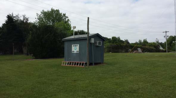
19 (c) Site Photographs NORTH EAST SOUTH WEST 19
20 2. Hattie Avenue A (a) Site Table Site Name: Hattie Avenue A AQS Site Identification Number: Location: 1300 Hattie Avenue Winston-Salem, NC Latitude: N º Longitude: W º Elevation: 284 meters Date Monitor Established: Ozone May 21, 1993 Date Monitor Established: NO 2 January 1, 1984 Date Monitor Established SO 2 January 1, 1983 Nearest Road: Hattie Avenue Distance to Road: 27 meters Traffic Count 3 : 6000 Year of Count: 2013 MSA 4 Winston-Salem, NC Metropolitan Statistical Area : (2006) MSA #: Parameter Method Method Number Sampling Schedule Ozone UV Photometric 087 Continuous NO 2 Chemiluminescence 099 Continuous SO 2 UV Pulsed Fluorescence 560 Continuous Table 5 - Hattie Avenue "A" Monitoring Station Summary (b) Description and Statement of Purpose The Hattie Avenue A site monitors ozone, sulfur dioxide, and oxides of nitrogen. The site is located in the 1300 block of Hattie Avenue in downtown Winston- Salem. The site is located approximately 2.2 km NE of downtown, 1.1 km E of US52 and approximately 1.8 km NNW of Interstate 40 Business in a residential district at latitude N º and longitude W º. The site elevation is 284 meters. The nearest road, Hattie Avenue, is 27 meters from the inlets and has a daily traffic flow of 6000 vehicles (2013). The nearest tallest building is St. Benedict s Church (approximately 10 meters). The inlets are approximately 43 meters from the shopping center. The inlets are approximately 4 meters above the ground and 1 meter above the roof of the monitoring station. The area is residential. The ozone, sulfur dioxide, and NO 2 monitors are all SLAMS. The ozone instrument is operated during the North Carolina ozone monitoring season which begins April 1 and ends October 31. The ozone instrument operates continuously during this period. The SO 2 and NO 2 instruments operate continuously. The site complies with the siting requirements of 40CFR58 for criteria air pollutants. There is a tree drip-line nearing the minimum distance from the inlet 20
21 but we plan to remove these trees this summer (2015).. It is recommended that the current site status be maintained. OBJECTIVE AND SPATIAL SCALE The monitoring objectives of the instruments are to measure: 1) background ambient concentrations and 2) population exposure. The site is a neighborhood spatial scale. Data from this site is used to assess compliance with the NAAQS for ozone, sulfur dioxide, and nitrogen dioxide. The site is located in the Winston-Salem, NC Metropolitan Statistical Area 4. The principal cities and counties in the MSA are Winston-Salem, Davie County, Forsyth County, Stokes County, and Yadkin County, NC. 21
22 (c) Site Photographs NORTH EAST SOUTH WEST 22
23 3. Hattie Avenue B (a) Site Table Site Name: Hattie Avenue B AQS Site Identification Number: Location: 1300 Hattie Avenue Winston-Salem, NC Latitude: N º Longitude: W º Elevation: 284 meters Date Monitor Established: PM 2.5 FRM January 1, 1999 Date Monitor Established: PM 2.5 FRM 1/6 April 1, 2016 Date Monitor Established PM TEOM June 16, 1999 Date Monitor Established PM 10 - TEOM October 18, 1999 Date Monitor Established Air Toxics January 1, 2000 Traffic Count 3 : 6000 Year of Count: 2013 MSA 4 Winston-Salem, NC Metropolitan Statistical Area : (2006) MSA #: Parameter Method Method Number Sampling Schedule PM 2.5 FRM Gravimetric in 3 day PM 2.5 FRM Gravimetric in 6 day PM 2.5 MetOne, Speciation in 6 day PM 2.5 TEOM, Continuous 701, 702 Continuous PM 10 TEOM, Continuous 079 Continuous Air Toxics Compendium Method for Toxic Organics (TO) in 6 day Table 6 - Hattie Avenue "B" Monitoring Station Summary (b) Description and Statement of Purpose This Hattie Avenue site monitors PM 2.5 and PM 10. The site is located in the 1300 block of Hattie Avenue in Winston-Salem. The site is located approximately 2.2 km NE of downtown, 1.1 km E of US52 and approximately 1.8 km NNW of Interstate 40 Business in a residential district at latitude N º and longitude W º. The site elevation is 284 meters. The nearest road, Hattie Avenue, is 27 meters from the inlets and has a daily traffic flow of 6000 vehicles (2013). The nearest tallest building is St. Benedict s Church (approximately 10 meters). The inlets are approximately 43 meters from the shopping center. The inlets are approximately 4 meters above the ground and 1 meter above the roof of the monitoring station. The area is residential. The monitors are SLAMS. 23
24 The PM 2.5 FRM sampling frequency is on the 1 in 3 day schedule and the co-located FRM is on the 1 in 6 day.. The sampling interval is 24 hours, from midnight to midnight every day. The PM 2.5 Speciation sampling frequency is 1 in 6 days. The sampling interval is 24 hours, from midnight to midnight every six days. The PM 2.5 and PM 10 TEOM instruments operate continuously. Monitoring for Urban Air Toxics (UAT) is currently conducted at this site by the North Carolina Division of Air Quality (NC-DAQ), Toxics Protection Branch (TPB). Currently, the NC-DAQ TPB collects whole air samples in stainless steel 6 liter- pressurized canisters. The samples are then analyzed using cryogenic preconcentration gas chromatography with mass spectrometric detection (GC/MS) via the Compendium Method for Toxic Organics (TO) 15 for the list of 68 compounds (below). 24
25 Propene Freon 12 Freon 22 Freon 114 Chloro Methane (Methylchloride) Isobutene Vinyl chloride 1,3-Butadiene Bromomethane Chloroethane Freon 11 Pentane Ethanol Isoprene Acrolein 1,1-Dichloroethene (Vinylidene chloride) Freon 113 Methyl Iodide Isopropyl Alcohol Carbon Disulfide Acetonitrile Methylene chloride Cyclopentane MTBE Hexane Methacrolein Vinyl Acetate 1,1-Dichloroethane Methyl Vinyl Ketone Methyl Ethyl Ketone 1,2 Dichloroethene Chloroform 1,1,1-Trichloroethane (Methyl chloroform) Cyclohexane Carbon Tetrachloride Benzene 1,2-Dichloroethane (ethylene dichloride) 1-Butanol Trichloroethylene 2-Pentanone 3-Pentanone 1,2-Dichloropropane 1,4-Dioxane Bromodichloromethane trans-1,3 Dichloropropene Methyl Isobutyl Ketone Toluene cis-1,3 Dichloropropene 1,1,2-Trichloroethane (vinyl trichloride) Ethylpropylketone Tetrachloroethylene (perchloroethylene) Methyl Butyl Ketone Dibromoethane Chlorobenzene (phenylchloride) Ethylbenzene m- & p-xylene o-xylene Styrene Bromoform 1,1,2,2- Tetrachloroethane 1,3,5-Trimethylbenzene (mesitylene) 1,2,4-Trimethylbenzene (pseudocumene) m-dichlorobenzene 1,2,3-Trimethylbenzene p-dichlorobenzene Benzylchloride o-dichlorobenzene 1,2,4-Trichlorobenzene
26 The site complies with the siting requirements of 40CFR58 for criteria air pollutants. There are no proposed changes for this site. It is recommended that the current site status be maintained. OBJECTIVE AND SPATIAL SCALE The monitoring objective of the instruments is to measure population exposure. The site is a neighborhood spatial scale. Data from this site is used to assess compliance with the NAAQS for PM 2.5 and PM 10. The site is located in the Winston-Salem, NC Metropolitan Statistical Area 4. The principal cities and counties in the MSA are Winston-Salem, Davie County, Forsyth County, Stokes County, and Yadkin County, NC. 26


27 (c) Site Photographs NORTH EAST SOUTH WEST 27
28 4. Union Cross (a) Site Table Site Name: Union Cross AQS Site Identification Number: Location: 3656 Piedmont Memorial Drive Winston-Salem, NC Latitude: N º Longitude: W º Elevation: 285 meters Date Monitor Established: Ozone April 1, 1998 Nearest Road: Piedmont Memorial Dr. Distance to Road: 55 meters Traffic Count 3 : 650 Year of Count: 2011 MSA 4 Winston-Salem, NC Metropolitan Statistical Area : (2006) MSA #: Parameter Method Method Number Sampling Schedule Ozone UV Photometry 087 Continuous Wind Speed Climatronics 020 Continuous Wind Direction Climatronics 020 Continuous Pressure R. M. Young 011 Continuous Outdoor Temperature R. M. Young 020 Continuous Relative Humidity R. M. Young 020 Continuous Table 7 - Union Cross Monitoring Station Summary (b) Site Description and Statement of Purpose An ozone monitor has been located at this site since April 1, 1998 along with a meteorological tower since The site is located approximately 10 km SE of the central business district at latitude and longitude The site elevation is 285 meters above sea level. The nearest road is Piedmont Memorial Drive with an annual traffic volume of 650 vehicles (2011) at a distance of 55 meters from the sample inlet. The inlet is approximately 4 meters above the ground and 1 meter from the roof. There is a tree drip-line nearing the minimum distance from the inlet but we plan to remove these trees this summer (2016). The area is residential. The ozone sampler is SLAMS. The ozone instrument is operated during the North Carolina ozone monitoring season which begins April 1 and ends October 31. The ozone instrument operates continuously during this period. 28
29 The site complies with the siting requirements of 40CFR58 for criteria air pollutants. There are no proposed changes for this site. It is recommended that the current site status be maintained. OBJECTIVE AND SPATIAL SCALE The monitoring objective of the instrument is to measure population exposure. The site is a neighborhood spatial scale for ozone. Data from this site is used to assess compliance with the NAAQS for ozone. The site is located in the Winston-Salem, NC Metropolitan Statistical Area 4. The principal cities and counties in the MSA are Winston-Salem, Davie County, Forsyth County, Stokes County, and Yadkin County, NC. 29


30 (c) Site Photographs NORTH EAST SOUTH WEST 30
31 References 1. Title 40 Code of Federal Regulations Part 58, Ambient Air Quality Surveillance. Part 58 and Part 58 Amended: Federal Register/Vol. 71 No. 200/Tuesday, October 17, 2006/Rules and Regulations. 2. Watson, John G., Chow, Judith C., DuBois, David, Green, Mark, Frank, Neil, Pitchford, Marc. Guidance for Network Design and Optimum Site Exposure for PM2.5 and PM10. Office of Air Quality Planning and Standards, U. S. Environmental Protection Agency, Research Triangle Park, NC December 15, Winston-Salem Department of Transportation. Current Traffic Counts Note: Traffic Count taken from nearest road providing most impact to site 4. US Census Bureau. Current Lists of Metropolitan and Micropolitan Statistical Areas and Definitions. (301)
32 2015 Annual Monitoring Network Plan No comments were received. Appendix A 32
33 2013 Annual Monitoring Network Plan Appendix B No comments were received. 33
Annual Monitoring Network Plan for the North Carolina Division of Air Quality
 2017-2018 Annual Monitoring Network Plan for the North Carolina Division of Air Quality Volume 2 Site Descriptions by Division of Air Quality Regional Office and Metropolitan Statistical Area B. The Winston-Salem
Air Quality Monitoring Group Annual Monitoring Network Plan - Mecklenburg County Air Quality
 Air Quality Monitoring Group 2017-2018 Annual Monitoring Network Plan - Mecklenburg County Air Quality Mecklenburg County Air Quality A Division of the Mecklenburg County Land Use and Environmental Services
MECKLENBURG COUNTY Land Use and Environmental Services Agency - A I R Q U A L I T Y - February 17, 2016
 MECKLENBURG COUNTY Land Use and Environmental Services Agency - A I R Q U A L I T Y - February 17, 2016 Beverly Banister, Director Air, Pesticides & Toxics Management Division U.S. EPA, Region 4 Sam Nunn
2018 ANNUAL NETWORK PLAN DIVISION OF NATURAL RESOURCES AND ENVIRONMENTAL MANAGEMENT AMBIENT AIR QUALITY MONITORING PROGRAM CITY OF HUNTSVILLE, ALABAMA
 2018 ANNUAL NETWORK PLAN DIVISION OF NATURAL RESOURCES AND ENVIRONMENTAL MANAGEMENT AMBIENT AIR QUALITY MONITORING PROGRAM CITY OF HUNTSVILLE, ALABAMA NATURAL RESOURCES AND ENVIRONMENTAL MANAGEMENT Post
OREGON Environmental Laboratory Accreditation Program ORELAP Fields of Accreditation
 MATRIX Reference Code Analyte Code Description STAT Analysis Corporation 40 CFR Part 50 Appendix J Environmental Laboratory Program 3950 Particulates
QUALITY ASSURANCE PROJECT PLAN (QAPP)
") Page 1 of 109 QUALITY ASSURANCE PROJECT PLAN (QAPP) FOR AMBIENT AIR QUALITY MONITORING OF CRITERIA AIR POLLUTANTS 9/5/17 SUBMITTED BY THE FORSYTH COUNTY OFFICE OF ENVIRONMENTAL ASSISTANCE AND PROTECTION
Page 1 of 109 QUALITY ASSURANCE PROJECT PLAN (QAPP) FOR AMBIENT AIR QUALITY MONITORING OF CRITERIA AIR POLLUTANTS 9/5/17 SUBMITTED BY THE FORSYTH COUNTY OFFICE OF ENVIRONMENTAL ASSISTANCE AND PROTECTION
2015 Ambient Air Quality Monitoring 5 Year Network Assessment For Mecklenburg County Air Quality
 M E C K L E N B U R G C O U N T Y A I R Q U A L I T Y A I R Q U A L I T Y M O N I T O R I N G G R O U P 2015 Ambient Air Quality Monitoring 5 Year Network Assessment For Mecklenburg County Air Quality
Collegeville Area Air Monitoring Project Third Report. November 17, Commonwealth of Pennsylvania Department of Environmental Protection
 Third Report Commonwealth of Pennsylvania Department of Environmental Protection Edward G. Rendell, Governor Commonwealth of Pennsylvania John Hanger, Secretary Department of Environmental Protection Prepared
Certificate of Accreditation
 PERRY JOHNSON LABORATORY ACCREDITATION, INC. Certificate of Accreditation Perry Johnson Laboratory Accreditation, Inc. has assessed the Laboratory of: (Hereinafter called the Organization) and hereby declares
Collegeville Area Air Monitoring Project Second Report. March 7, Commonwealth of Pennsylvania Department of Environmental Protection
 Second Report Commonwealth of Pennsylvania Department of Environmental Protection Edward G. Rendell, Governor Commonwealth of Pennsylvania Kathleen A. McGinty, Secretary Department of Environmental Protection
Annual Monitoring Network Plan for the North Carolina Division of Air Quality. Volume 1 Addendum 2
 2016-2017 Annual Monitoring Network Plan for the North Carolina Division of Air Quality Volume 1 Addendum 2 December 28, 2016 North Carolina Division of Air Quality A Division of the North Carolina Department
OREGON Environmental Laboratory Accreditation Program ORELAP Fields of Accreditation RJ Lee Group, Inc./Columbia Basin Analytical Laboratories
 MATRIX Reference Code Analyte Code Description Air EPA TO-11A 10311805 Determination of Formaldehyde in Ambient Air Using Adsorbent Cartridge Followed by High Performance Liquid Chromatography (HPLC) 6110
Urban Air Toxics Concentrations In Denver. May 2002 through April 2003
 Urban Air Toxics Concentrations In Denver May 2002 through April 2003 October 2006 Prepared by the Colorado Department of Public Health & Environment Air Pollution Control Division (Technical Services
Standard Operating Procedure (SOP) for. Completing the Annual Network Review. for the. North Carolina Division of Air Quality (DAQ) SECTION 2
 for. Completing the Annual Network Review. for the. North Carolina Division of Air Quality (DAQ) SECTION 2") Page 1 of 36 Standard Operating Procedure (SOP) for Completing the Annual Network Review for the North Carolina Division of Air Quality (DAQ) SECTION 2 Page 3 of 36 Table of Contents 2.43 Standard Operating
Page 1 of 36 Standard Operating Procedure (SOP) for Completing the Annual Network Review for the North Carolina Division of Air Quality (DAQ) SECTION 2 Page 3 of 36 Table of Contents 2.43 Standard Operating
PM 2.5 Continuous Monitoring. Program Objectives, History, Requirements, and Flexibility. National Ambient Air Monitoring Conference Atlanta 2014
 PM 2.5 Continuous Monitoring Program Objectives, History, Requirements, and Flexibility National Ambient Air Monitoring Conference Atlanta 2014 1 Program Objectives, History, Requirements, and Flexibility
Gila River Indian Community 2016 AMBIENT AIR MONITORING NETWORK REVIEW
 Gila River Indian Community 2016 AMBIENT AIR MONITORING NETWORK REVIEW GRIC San Tan Mountains to the north, 2016 Gila River Indian Community Department of Environmental Quality Air Quality Air Monitoring
Date Issued: July 01, 2017 Expiration Date: June 30, 2018
 State of Florida Department of Health, Bureau of Public Health Laboratories This is to certify that MAXXAM ANALYTICS - MICHIGAN 22345 ROETHEL DRIVE NOVI, MI 48375 has complied with Florida Administrative
Clean Harbors (Sarnia) Air Monitoring Plan and Sampling Results
 Air Monitoring Plan and Sampling Results") Clean Harbors (Sarnia) Air Monitoring Plan and Sampling Results Southwestern Region - Technical Support Section Updated October 21, 2011 Executive Summary The ministry is conducting air sampling in the
Clean Harbors (Sarnia) Air Monitoring Plan and Sampling Results Southwestern Region - Technical Support Section Updated October 21, 2011 Executive Summary The ministry is conducting air sampling in the
2013 ANNUAL AIR MONITORING NETWORK PLAN CHECKLIST (Updated 2/27/2013) Year: Agency:
 Year: Agency:") 2013 ANNUAL AIR MONITORING NETWORK PLAN CHECKLIST (Updated 2/27/2013) Year: Agency: 40.10(a)(1) requires that each ANP include regarding the following types of monitors: SLAMS monitoring stations including
2013 ANNUAL AIR MONITORING NETWORK PLAN CHECKLIST (Updated 2/27/2013) Year: Agency: 40.10(a)(1) requires that each ANP include regarding the following types of monitors: SLAMS monitoring stations including
2012 AMBIENT AIR MONITORING NETWORK PLAN
 2012 AMBIENT AIR MONITORING NETWORK PLAN Monitoring and Compliance Division July 9, 2012 SLOAPCD 2012 Network Plan - 1-7/9/2012 Table of Contents 1. Introduction... 1 2. Overview of Network Operation...
2010 Air Toxics Summary
 2010 Air Toxics Summary New Jersey Department of Environmental Protection INTRODUCTION Air pollutants can be divided into two categories: the criteria pollutants (ozone, sulfur dioxide, carbon monoxide,
Pottstown Area Air Monitoring Final Report. January 19, Commonwealth of Pennsylvania Department of Environmental Protection
 Pottstown Area Air Monitoring Final Report Commonwealth of Pennsylvania Department of Environmental Protection Edward G. Rendell, Governor Commonwealth of Pennsylvania Kathleen A. McGinty, Secretary Department
CERTIFICATE OF ACCREDITATION
 CERTIFICATE OF ACCREDITATION ANSI-ASQ National Accreditation Board 500 Montgomery Street, Suite 625, Alexandria, VA 22314, 877-344-3044 This is to certify that Environmental Conservation Laboratories -
APPENDIX C: Bakersfield-Golden AMS Closure and Replacement
 APPENDIX C: Bakersfield-Golden AMS Closure and Replacement Appendix C: Bakersfield-Golden AMS Closure and Replacement This page is intentionally blank. Appendix C: Bakersfield-Golden AMS Closure and Replacement
Long-Term Ambient Air Monitoring Project near Permanent Marcellus Shale Gas Facilities Protocol
 Long-Term Ambient Air Monitoring Project near Permanent Marcellus Shale Gas Facilities Protocol July 23, 2012 Commonwealth of Pennsylvania Department of Environmental Protection Tom Corbett, Governor Commonwealth
Designing a Network Assessment for an Ambient Air Monitoring Program
 This document is intended to help facilitate compiling an assessment of an agency s air quality surveillance system by State and where delegated, local air monitoring programs. The requirement to submit
2017 Annual Network Plan for Ambient Air Monitoring
 2017 Annual Network Plan for Ambient Air Monitoring July 1, 2017 North Coast Unified Air Quality Management District 707 L Street, Eureka, CA 95501 Telephone (707) 443-3093 - FAX (707) 443-3099 http://www.ncuaqmd.org
Oklahoma Department of Environmental Quality Air Quality Division Monitoring Section Annual Network Review for Ambient Air Monitoring Fiscal Year 2013
 Oklahoma Department of Environmental Quality Air Quality Division Monitoring Section Annual Network Review for Ambient Air Monitoring Fiscal Year 2013 Under 40 CFR, Part 58, Subpart B, states are required
2018 Annual Network Plan for Ambient Air Monitoring
 2018 Annual Network Plan for Ambient Air Monitoring July 1, 2018 North Coast Unified Air Quality Management District 707 L Street, Eureka, CA 95501 (707) 443-3093 www.ncuaqmd.org Contents Contents... 2
Lambton Facility Update
 Lambton Facility Update Friday, October 28, 2011 On-site Control Measure Update Over the past week, company personnel noticed a slight increase in on-site odours and in order to minimize off-site odours
Appendix B National Core (NCore) Multi-pollutant Monitoring
 Multi-pollutant Monitoring") Appendix B National Core (NCore) Multi-pollutant Monitoring Table of Contents Background...B-1 NCore Monitoring in Minnesota...B-2 Monitoring Objective...B-2 Quality Assurance Status...B-4 Area of Representativeness...B-4
Appendix B National Core (NCore) Multi-pollutant Monitoring Table of Contents Background...B-1 NCore Monitoring in Minnesota...B-2 Monitoring Objective...B-2 Quality Assurance Status...B-4 Area of Representativeness...B-4
North Minneapolis Air Monitoring Study: 2015 Data Summary
 North Minneapolis Air Monitoring Study: 2015 Data Summary March 2016 Authors Cassie McMahon The MPCA is reducing printing and mailing costs by using the Internet to distribute reports and information to
SCOPE OF ACCREDITATION TO ISO/IEC 17025:2005
 SCOPE OF ACCREDITATION TO ISO/IEC 17025:2005 ENVIRONMENTAL CONSERVATION LABORATORIES JACKSONVILLE 4810 Executive Park Court, Suite 111 Jacksonville, FL 32216 Lori S. Mangrum Phone: 904 296 3007 Email address:
2017 Air Toxics Summary
 2017 Air Toxics Summary New Jersey Department of Environmental Protection INTRODUCTION Air pollutants can be generally divided into two categories: criteria pollutants (ozone, sulfur dioxide, carbon monoxide,
DIVISION OF WASTE MANAGEMENT RESIDENTIAL VAPOR INTRUSION SCREENING CONCENTRATIONS (March, 2016)
") Note: The Residential screening level below or site specific screening concentrations (utilizing site specific attenuation and exposure factors) can be used. In either case the site s remedy must include
Note: The Residential screening level below or site specific screening concentrations (utilizing site specific attenuation and exposure factors) can be used. In either case the site s remedy must include
Texas Commission on Environmental Quality
 These fields of accreditation supercede all previous fields. The urges customers to Matrix: Air & Emissions Method 40 CFR Part 50 Appendix B Total Suspended Particulate TX 3973 10000304 Method 40 CFR Part
Thermal Desorption Technical Support Note 87: A cryogen-free method for monitoring trace greenhouse gases in air. Key Words:
 Thermal Desorption Technical Support Note 87: A cryogen-free method for monitoring trace greenhouse gases in air Key Words: Trace greenhouse gases, Kyoto Protocol, CFCs, HCFCs, UNITY 2, CIA 8, air toxics,
2012 Air Toxics Summary
 2012 Air Toxics Summary New Jersey Department of Environmental Protection INTRODUCTION Air pollutants can be divided into two categories: the criteria pollutants (ozone, sulfur dioxide, carbon monoxide,
TSB-1 TSB-3 TSB-2. Legend. Approximate Site Limits. Soil Boring Location. Feet. Figure 2 Boring Location Map
 TSB-1 TSB-3 TSB-2 Legend 0 150 300 450 600 Feet East of Calhoun Road & South of Griggs Road Houston, Harris County, Texas TGE Project No.: R10114.01 6120 West by Northwest Blvd. Suite 100 Houston, Texas
Long-Term Ambient Air Monitoring Project near Permanent Marcellus Shale Gas Facilities Protocol
 Long-Term Ambient Air Monitoring Project near Permanent Marcellus Shale Gas Facilities Protocol July 23, 2012 Commonwealth of Pennsylvania Department of Environmental Protection Tom Corbett, Governor Commonwealth
Thermal Desorption Technical Support
 Thermal Desorption Technical Support Note 79: Air monitoring - the respective advantages and applications of canisters and tubes Key Words: Environmental, Air toxics, Canisters, On-line sampling Introduction
2013 Network Summary
 R 2013 Network Summary New Jersey Department of Environmental Protection NETWORK DESCRIPTION In 2013, the New Jersey Department of Environmental Protection (NJDEP) operated 39 ambient air monitoring stations.
North Minneapolis Air Monitoring: 2016 Data Summary
 Air Monitoring November 2017 North Minneapolis Air Monitoring: 2016 Data Summary Author Cassie McMahon The MPCA is reducing printing and mailing costs by using the Internet to distribute reports and information
North Minneapolis Air Monitoring Study: 2017 Data Summary
 Air Monitoring January 2019 North Minneapolis Air Monitoring Study: 2017 Data Summary Authors Derek Nagel Cassie McMahon Contributors/acknowledgements Luke Charpentier Kurt Anderson The MPCA is reducing
Annual Monitoring Network Plan for the North Carolina Division of Air Quality. Volume 1 Addendum
 2016-2017 Annual Monitoring Network Plan for the North Carolina Division of Air Quality Volume 1 Addendum September 1, 2016 North Carolina Division of Air Quality A Division of the North Carolina Department
US EPA Method 8260 With the Tekmar Lumin and the Agilent 7890B GC/5977A MS
 Application Note US EPA Method 8260 With the Tekmar Lumin and the Agilent 7890B GC/5977A MS Author Roger Bardsley Applications Chemist, Teledyne Tekmar Abstract US EPA Method 8260 is used primarily by
Appendix A Analytical Methods for Air Sampling
 Analytical s Air Sampling Acenaphthene TO-13A PUF / XAD 10 0.4 Acenaphthylene TO-13A PUF / XAD 10 0.35 Acetaldehyde Acetone TO-15 Can or Bag 1.9 0.47 Acetonitrile TO-15 Can or Bag 1.7 0.12 Acetophenone
Ground Water Screening Level (GWSL) 1,2 ug/l TCR = 1.0E-05/HQ =0.2. Sub-slab and Exterior Soil Gas Screening Level (SGSL) 1,2.
 1,2 ug/l TCR = 1.0E-05/HQ =0.2. Sub-slab and Exterior Soil Gas Screening Level (SGSL) 1,2.") Note: The non-residential screening level below or site specific screening concentrations (utilizing site specific attenuation and exposure factors) can be used. In either case the site s remedy must include
Note: The non-residential screening level below or site specific screening concentrations (utilizing site specific attenuation and exposure factors) can be used. In either case the site s remedy must include
SCOTT Method TO-14A/15/17
 SCOTT Method TO-14A/15/17 Calibration Standards Benefits and Features SCOTT technical expertise in engineering Method 14A/15/17, HAPS and TIC calibration standards, sulfur mixes and vapor intrusion products
National Air Toxics Trends Study In Grand Junction, Colorado. January through December 2007
 National Air Toxics Trends Study In Grand Junction, Colorado January through December 2007 January 2011 Prepared by the Colorado Department of Public Health & Environment Air Pollution Control Division
2015 FIVE-YEAR NETWORK ASSESSMENT FOR NORTH CAROLINA
 2015 FIVE-YEAR NETWORK ASSESSMENT FOR NORTH CAROLINA July 22, 2015 North Carolina Division of Air Quality A division of the North Carolina Department of Environment and Natural Resources Mail Service Center
Annual Monitoring Network Plan for the North Carolina Division of Air Quality
 2017-2018 Annual Monitoring Network Plan for the North Carolina Division of Air Quality Volume 2 Site Descriptions by Metropolitan Statistical Area G. The Wilmington Monitoring Region June 30, 2017 Table
Pottstown Area Air Monitoring. May 12, Commonwealth of Pennsylvania Department of Environmental Protection
 Pottstown Area Air Monitoring Commonwealth of Pennsylvania Department of Environmental Protection Edward G. Rendell, Governor Commonwealth of Pennsylvania Kathleen A. McGinty, Secretary Department of Environmental
VENTURA COUNTY AIR POLLUTION CONTROL DISTRICT 2009 AMBIENT AIR MONITORING NETWORK PLAN. September County Square Drive Ventura, CA 93003
 VENTURA COUNTY AIR POLLUTION CONTROL DISTRICT 2009 AMBIENT AIR MONITORING NETWORK PLAN September 2009 669 County Square Drive Ventura, CA 93003 Contact: Keith Duval Table of Contents 1. 0 Introduction..................................................................................................................
US EPA Method 8260 with the Atomx XYZ and the Thermo Scientific TRACE 1310 GC and ISQ MS
 APPLICATION NOTE: TECHNOLOGY: INDUSTRY: AN1803 P+T VOC ENV US EPA Method 8260 with the Atomx XYZ and the Thermo Scientific TRACE 1310 GC and ISQ MS Amy Nutter, Applications Chemist; Teledyne Tekmar Page
Community Air Monitoring Project Results Summary St. Paul: St. Anthony Park Neighborhood
 Community Air Monitoring Project Results Summary St. Paul: St. Anthony Park Neighborhood Project overview The Community Air Monitoring Project (CAMP) is an air monitoring study, funded by the Minnesota
Appendix B: Minimum Monitoring Requirements and 2016 Monitor Classifications in AQS
 Appendix B: Minimum ing Requirements and 2016 Classifications in AQS Summary The EPA establishes the minimum number of monitoring sites required to meet national ambient monitoring objectives. The minimum
State of Nevada Department of Conservation and Natural Resources Division of Environmental Protection Laboratory Scope of Accreditation
 Matrix: CWA (Non Potable Water) Discipline Chemistry EPA 1664A (SGT-HEM) n-hexane Extractable Material - Silica Gel Treated (HEM-SGT) 8/21/2015 Aluminum 8/21/2015 Arsenic 8/21/2015 Barium 8/21/2015 Beryllium
Roger Bardsley, Applications Chemist; Teledyne Tekmar Page 1
 Application Note US EPA Method 524.4 with the Tekmar Lumin P & T Concentrator and Agilent 7890B GC and 5977A MSD System Roger Bardsley, Applications Chemist; Teledyne Tekmar Page 1 Abstract US EPA Method
Pinal County Air Quality Control District Ambient Monitoring Network Plan And 2009 Data Summary
 Pinal County Air Quality Control District 2010 Ambient Monitoring Network Plan And 2009 Data Summary June 30, 2010 Final Pinal County Air Quality 31 N. Pinal St., Bldg. F P.O. Box 987 Florence AZ, 85132
AGENDA. 2) Presentation on 2014 (to date) SETRPC Ambient Air Monitoring Network Data for Ozone and Air Toxics Al Hendler, URS Corporation Austin, TX
 Presentation on 2014 (to date) SETRPC Ambient Air Monitoring Network Data for Ozone and Air Toxics Al Hendler, URS Corporation Austin, TX") South East Texas Regional Planning Commission (SETRPC) Air Quality Advisory Committee Meeting on Rider 8 Air Quality Planning Activities MCM Elegante Hotel, Fountainview Room 2355 IH-10 South, Beaumont,
South East Texas Regional Planning Commission (SETRPC) Air Quality Advisory Committee Meeting on Rider 8 Air Quality Planning Activities MCM Elegante Hotel, Fountainview Room 2355 IH-10 South, Beaumont,
San Joaquin Valley Air Pollution Control District. Air Monitoring Network Plan
 San Joaquin Valley Air Pollution Control District Air Monitoring Network Plan June 30, 2010 For Submittal to the U.S. Environmental Protection Agency in July 2010 San Joaquin Valley Unified Air Pollution
National Air Toxics Trends Study In Grand Junction, Colorado. January through December 2004
 National Air Toxics Trends Study In Grand Junction, Colorado January through December 2004 January 2006 Prepared by the Colorado Department of Public Health & Environment Air Pollution Control Division
Amy Nutter, Applications Chemist; Teledyne Tekmar P a g e 1
 Application Note US EPA Method 8260 with the Tekmar Atomx XYZ P&T System and Agilent 7890B GC/5977A MS Amy Nutter, Applications Chemist; Teledyne Tekmar P a g e 1 Abstract US EPA Method 8260 in conjunction
Roger Bardsley, Applications Chemist; Teledyne Tekmar P a g e 1
 Application Note US EPA Method 524.3 with the Tekmar Lumin P & T Concentrator and Agilent 7890B GC and 5977A MSD System Roger Bardsley, Applications Chemist; Teledyne Tekmar P a g e 1 Abstract US EPA Method
MEMORANDUM. To: Billy Meyer. Christie Zawtocki, PE Kitty Hiortdahl, EI. Date: March 12, 2015
 MEMORANDUM To: Billy Meyer From: Christie Zawtocki, PE Kitty Hiortdahl, EI Date: March 12, 2015 Project: One Hour Martinizing Site, DSCA ID 32-0013 1103 W Club Blvd, Durham, NC Subject: Project Update
BACKGROUND LEVELS OF VOLATILE ORGANIC CHEMICALS IN HOMES: A REVIEW OF RECENT LITERATURE
 BACKGROUND LEVELS OF VOLATILE ORGANIC CHEMICALS IN HOMES: A REVIEW OF RECENT LITERATURE Introduction For over 20 years, it has been known that many volatile organic chemicals are present in the indoor
2017 Air Monitoring Network Plan
 San Joaquin Valley Air Pollution Control District June 28, 2017 This page is intentionally blank. San Joaquin Valley Unified Air Pollution Control District June 28, 2017 TABLE OF CONTENTS The District
Fiscal, Administrative & Technical Services May 2018 Public Review Draft
 2018 Ambient Air Monitoring Network Plan Fiscal, Administrative & Technical Services May 2018 Public Review Draft Table of Contents List of Abbreviations... 4 Introduction... 5 General Information on Air
Charles Sarnoski Delaware Department of Natural Resources & Environmental Control Division of Air Quality
 Charles Sarnoski Delaware Department of Natural Resources & Environmental Control Division of Air Quality Thermal Desorption before TO-17 circa 1982 Why an Interest in Air Toxics? 2003 Delaware Air Toxics
2016 PORTSMOUTH LAA MONITORING SITES
 2016 PORTSMOUTH LAA MONITORING SITES Map/AQS # Site Name PM 2.5 PM 10 O 3 SO 2 CO NO 2 TOXICS PM 2.5 CSPE Pb/metals Met 1. 39-001-0001 West Union x x 2. 39-087-0011 Wilgus x 3. 39-087-0012 Ironton ODOT
Ambient Air Quality Monitoring
 Ambient Air Quality Monitoring Ambient Air Quality Division Air Quality and Noise Management Bureau Pollution Control Department 7/31/2012 2:09 PM 1 Carbon Monoxide (CO) Nitrogen Dioxide (NO 2 ) Ozone
Using Alternative Carrier Gas for US EPA Application Note. Abstract. Introduction. Experimental-Instrument Conditions
 Using Alternative Carrier Gas for US EPA 524.3 Application Note Abstract Due to regional shortages and increasing costs of helium, the preferred carrier gas in gas chromatography, alternative carrier gas
State Regulations (Part 360) Landfill setting Monitoring activities Results Potential Impacts
 Landfill setting Monitoring activities Results Potential Impacts") State Regulations (Part 360) Landfill setting Monitoring activities Results Potential Impacts Environmental monitoring is just one of many landfill activities regulated by the state, including Permit application
State Regulations (Part 360) Landfill setting Monitoring activities Results Potential Impacts Environmental monitoring is just one of many landfill activities regulated by the state, including Permit application
Ohio Air Monitoring 222 Network Plan for the Gavin/Kyger Sulfur Dioxide Monitoring Network
 2016-2017 Ohio Air Monitoring 222 Network Plan for the Gavin/Kyger Sulfur Dioxide Monitoring Network Division of Air Pollution Control December 2016 Table of Contents Requirements and Guidance... 1 Gavin/Kyger
2017 Ambient Air Monitoring Network Plan
 2017 Ambient Air Monitoring Network Plan Fiscal, Administrative & Technical Services June 2017 Table of Contents List of Abbreviations... 4 Introduction... 5 General Information on Air Monitoring Networks...
Exact Scientific Services, Inc. Ferndale, WA
 Ferndale, WA has complied with provisions set forth in Chapter 173-50 WAC and is hereby recognized by the Department of Ecology as an ACCREDITED LABORATORY for the analytical parameters listed on the accompanying
2016 NWDO AIR MONITORING SITES
 2016 NWDO AIR MONITORING SITES Map/AQS # Site Name PM2.5 PM2.5CONT. PM10 O3 SO2 CO NO2 TOXICS PM2.5CSPE Pb/metals 1. 39-003-0009 Lima Bath HS x* x x x 2. 39-051-0001 Delta x* 3. 39-173-0003 Bowling Green
2015 PORTSMOUTH LAA MONITORING SITES
 2015 PORTSMOUTH LAA MONITORING SITES Map/AQS # Site Name PM 2.5 PM 10 O 3 SO 2 CO NO 2 TOXICS PM 2.5 CSPE NCORE Pb/metals 1. 39-001-0001 West Union x x 2. 39-087-0011 Wilgus x 3. 39-087-0012 Ironton ODOT
Wyoming Ambient Air Monitoring Annual Network Plan 2013 June 27, 2013
 Wyoming Ambient Air Monitoring Annual Network Plan 2013 June 27, 2013 Photo by Jennifer Frazier TABLE OF CONTENTS 1.0 Introduction... 1 1.1 The AQD Monitoring History... 1 1.2 General Monitoring Goals
Dynamic Small-Scale Chamber Emissions Testing
 Dynamic Small-Scale Chamber Emissions Testing Compliance Report per California Dept. of Public Health Standard Method Version 1.1 and FloorScore Selit Bloc Underlayment Prepared for: 550 Old Peachtree
Risk Management Plan Ho Cleaners DSCA ID No Matthews, Mecklenburg County H&H Job No. DS0-14J. Table of Contents
 Risk Management Plan Ho Cleaners DSCA ID No. 60-0034 Matthews, Mecklenburg County H&H Job No. DS0-14J Table of Contents 1.0 Introduction...1 2.0 RMP Objectives...1 3.0 Summary of Approved Risk Assessment
INDOOR AIR QUALITY TESTING IN JONES MIDDLE SCHOOL, 2100 ARLINGTON AVENUE, UPPER ARLINGTON, OHIO
 IOOR AIR QUALITY TESTING IN JONES MIDDLE SCHOOL, 200 ARLINGTON AVENUE, UPPER ARLINGTON, OHIO Prepared for Mr. Chris Potts UPPER ARLINGTON SCHOOLS 950 North Mallway Drive Upper Arlington, Ohio 4322 Prepared
North Carolina Cleanup Standards for Hydrocarbon Contaminated Groundwater
 North Carolina Cleanup Standards for Hydrocarbon Contaminated Groundwater The North Carolina Department of Environment and Natural Resources has adopted Risk-Based Assessment and Corrective Action procedures
MacAleese Lane Air Quality Report Monitoring Program
 MacAleese Lane Air Quality Report 2009 Monitoring Program Department of Environment April 2010 MacAleese Lane Air Quality Report 2009 Monitoring Program Introduction In February of 2009, the New Brunswick
San Joaquin Valley Air Pollution Control District Air Monitoring Network Plan
 San Joaquin Valley Unified Air Pollution Control District June 30, 2011 San Joaquin Valley Air Pollution Control District 2011 Air Monitoring Network Plan June 30, 2011 For Submittal to the U.S. Environmental
WEEKLY PROGRESS REPORT TRC SOLUTIONS. Gowanus Canal Turning Basin 4 Dredging and Capping Pilot Study Brooklyn, New York. Project number:
 WEEKLY PROGRESS REPORT TRC SOLUTIONS Gowanus Canal Turning Basin 4 Dredging and Capping Pilot Study Brooklyn, New York Project number: 283126 Period: November 26 to 30, 2018 Date of Report: December 5,
H&H Job No. DS0-10. January 14, South Tryon Street Suite 100 Charlotte, NC
 Risk Management Plan A Cleaner World DSCA ID No. 34-0013 101 S. Peace Haven Road Winston-Salem, Forsyth County North Carolina Dry-Cleaning Solvent Cleanup Act Program H&H Job No. DS0-10 January 14, 2011
PAMS Re-Engineering. NACA Monitoring Steering Committee Meeting July 19, Kevin A. Cavender EPA/OAR/OAQPS
 PAMS Re-Engineering NACA Monitoring Steering Committee Meeting July 19, 2012 Kevin A. Cavender EPA/OAR/OAQPS Outline Network Design Target compound list VOC Measurements Nitrogen Measurements Meteorological
SCOPE OF ACCREDITATION TO ISO/IEC 17025:2005
 SCOPE OF ACCREDITATION TO ISO/IEC 17025:2005 Pace Analytical Services, LLC. 150 N 9 th Street Billings, MT 59101 Emily Agola Phone: (616) 656-2257 Emily.Agola@pacelabs.com ENVIRONMENTAL Valid To: May 31,
TITLE 800 AIRPORT CORPORATION. Introduction 800 RICR CHAPTER 10 OPERATIONS SUBCHAPTER 00 N/A. PART 3 Air Quality Monitoring Work Plan
 800 RICR 10 00 03 TITLE 800 AIRPORT CORPORATION CHAPTER 10 OPERATIONS SUBCHAPTER 00 N/A PART 3 Air Quality Monitoring Work Plan 3.1 Introduction A. The Rhode Island Airport Corporation (RIAC) operates
Date Issued: July 01, 2018 Expiration Date: June 30, 2019
 State of Florida Department of Health, Bureau of Public Health Laboratories This is to certify that EMSL ANALYTICAL, INC - CINNAMINSON 200 ROUTE 130 NORTH CINNAMINSON, NJ 08077 has complied with Florida
North Carolina Certification For Clean Air Act Section 110(a)(1) and (2) Hour Ozone Requirements
(1) and (2) Hour Ozone Requirements") North Carolina Certification For Clean Air Act Section 110(a)(1) and (2) 2008 8-Hour Ozone Requirements Under the Clean Air Act (CAA), States must submit State Implementation Plans (SIPs) for areas designated
North Carolina Certification For Clean Air Act Section 110(a)(1) and (2) 2008 8-Hour Ozone Requirements Under the Clean Air Act (CAA), States must submit State Implementation Plans (SIPs) for areas designated
APPENDIX B. Soil Sample Certificate of Analysis
 APPENDIX B Soil Sample Certificate of Analysis 5 SHOREHAM DR DOWNSVIEW, ON M3N1S4 SOIL ANALYSIS REVIEWED BY: Mike Muneswar, BSc (Chem), Senior Inorganic Analyst TRACE ORGANICS REVIEWED BY: Jacky Takeuchi,
WEEKLY PROGRESS REPORT TRC SOLUTIONS. Gowanus Canal Turning Basin 4 Dredging and Capping Pilot Study Brooklyn, New York. Project number:
 WEEKLY PROGRESS REPORT TRC SOLUTIONS Gowanus Canal Turning Basin 4 Dredging and Capping Pilot Study Brooklyn, New York Project number: 283126 Period: October 8 to 12, 2018 Date of Report: October 17, 2018
FREY ENVIRONMENTAL, INC.
 FREY ENVIRONMENTAL, INC. Environmental Geologists, Engineers, Assessors 2817 A Lafayette Avenue Newport Beach, CA 92663 (949) 723-1645 Fax (949) 723-1854 Email: Freyinc@freyinc.com June 18, 2014 770-01
Pasco County Florida. Water Monitoring Plan West Pasco Class I Landfill PA87-23, WACS # Revised April 2014
 Pasco County Florida Water Monitoring Plan West Pasco Class I Landfill PA87-23, WACS # 45799 Revised April 2014 Table of Contents Section 1 Introduction... 1 Section 2 Groundwater Quality Monitoring Network...
Swansea Ambient Air Monitoring Station (SAMS) 4 th Quarter PY2017 Air Quality Data Report
 4 th Quarter PY2017 Air Quality Data Report") Swansea Ambient Air Monitoring Station (SAMS) 4 th Quarter PY2017 Air Quality Data Report Prepared for the Colorado Department of Transportation and the, Department of Environmental Health Airtech/Montrose
Swansea Ambient Air Monitoring Station (SAMS) 4 th Quarter PY2017 Air Quality Data Report Prepared for the Colorado Department of Transportation and the, Department of Environmental Health Airtech/Montrose
List of Revisions since Last Version
 Urban Air Toxics Monitoring Network Page ii of 51 List of Revisions since Last Version 1. Comments by EPA Region 4 reviewing the last revision were addressed. 2. Aldehyde sampling and analysis was resumed
Example Airshed. Sample 2018 Annual Ambient Air Quality Monitoring Report
 Example Airshed Sample 2018 Annual Ambient Air Quality Monitoring Report 29 March 2019 DISCLAIMER: This sample annual report is provided as guidance only. The structure, look and layout of monthly and