City of Santa Paula Spears Manufacturing Helistop Project. Draft Initial Study - Negative Declaration
|
|
|
- Gordon Cox
- 6 years ago
- Views:
Transcription

1 Spears Manufacturing Helistop Project Draft Initial Study - Negative Declaration May 2014
2 Draft Initial Study Negative Declaration Prepared for: 970 Ventura Street Santa Paula, California Prepared with the assistance of: Rincon Consultants, Inc. 180 North Ashwood Avenue Ventura, California May 2014
3 This report is printed on 50% recycled paper.
4 Draft Initial Study-Negative Declaration TABLE OF CONTENTS Initial Study 1. Project title Lead agency name and address Contact person and phone number Project location Project sponsor s name and address General Plan designation Zoning Project Description Surrounding land uses and setting Other public agencies whose approval is required... 3 Environmental Factors Affected... 4 Determination... 5 Environmental Checklist... 6 Page Discussion I. Aesthetics... 6 II. Agricultural Resources... 7 III. Air Quality... 9 IV. Biological Resources V. Cultural Resources VI. Geology and Soils VII. Greenhouse Gas Emissions VIII. Hazards and Hazardous Materials IX. Hydrology and Water Quality X. Land Use and Planning XI. Mineral Resources XII. Noise XIII. Population and Housing XIV. Public Services XV. Recreation XVI. Transportation/Traffic XVII. Utilities and Service Systems XVIII. Mandatory Findings of Significance References i
5 Draft Initial Study-Negative Declaration List of Figures Figure 1 Regional Location Figure 2 Project Site and Vicinity Figure 3 Existing Land Use Figure 4 Site Plan List of Tables Table 1 Land Use Compatibility for Noise Environments Table 2 Sound Level Limits Table 3 Ambient Noise Measurements Table 4 Predicted Future Helistop Noise Levels Appendices Appendix A - Noise Assessment Study ii
6 Draft Initial Study-Negative Declaration INITIAL STUDY 1. Project title: Spears Manufacturing Helistop Project 2. Lead agency name and address: 970 Ventura Street Santa Paula, CA Contact person and phone number: Stratis Perros, Deputy Planning Director (805) Project location: The project site is located in the City of Santa Paula, at 140 West Santa Barbara Street. The following parcel comprises the project site: APNs: , , , acres, owned by Spears Manufacturing Company, used for industrial manufacturing and distribution. Figure 1 shows the regional location of the project site, and Figure 2 shows the project site and its vicinity. 5. Project sponsor s name and address: Spears Manufacturing Company 140 West Santa Barbara Street Santa Paula, California General Plan designation: Light Industrial (LI) 7. Zoning: Light Industrial (LI) 8. Project Description: The proposed project (the project ) would involve the development of a 1,444 square foot free standing helistop (helicopter landing facility). The helistop is intended to provide the company with a means of rapid access between its new Santa Paula facility and its corporate headquarters in Sylmar. T he helistop would consist of a free-standing steel structure topped by a 38 foot by 38 foot metal "helideck" landing surface approximately 14 feet above grade. Two stairways located at the northwestern and southwestern corners will provide access to the helideck. The helideck would be surrounded by a six foot wide metal "safety net" for fall protection. A minor amount of grading would occur to install the column footings of the helistop. A windcone, a safety 1
7 Draft Initial Study-Negative Declaration device that provides a pilot with a visual indication of local wind direction and speed, would be installed northwest of the helideck. A fire extinguisher meeting California Fire Code and National Fire Protection Agency (NFPA) criteria for helistops would be located near the helistop's southwestern corner. The helistop would not have lighting. No helicopters would be based on site. The helicopters that would land there are based at Agua Dulce Airport located off of Highway 14 in the Los Angeles Area. Flights and landings would only be made during daylight hours and only during visual meteorological conditions (VMC). There would be no nighttime helicopter operations and no operations during instrument meteorological conditions (IMC). All flights would take place during normal business hours, but could occur on any day of the week, including weekends. No landings or takeoffs would take place before 8:00 a.m. or after 5:00 p.m. A maximum of one landing and one takeoff would occur per day year round. The helistop has been designed to comply with the following publications: Federal Aviation Administration's Heliport Design Advisory Circular 150/5390-2C California Code of Regulations Title 21, Airports and Heliports NFPA Publication 418, Heliports In addition to the helistop itself and ancillary equipment described above, the following revisions would be made to the property to accommodate helicopter operations: Three light standards in the approximate center of the parking lot and other miscellaneous facilities in that area would be removed 9. Surrounding land uses and setting: The project site is located east of North Palm Ave on the south side of Santa Barbara Street. The site is bordered by the following uses: North: West Santa Barbara Street, multi-family residential and single family residential. East: Light industrial use immediately adjacent with single family residential, multi-family residential and commercial uses beyond that. South: Santa Paula Bike Trail, Southern Pacific Railroad and West Main Street. Single and multifamily residential and commercial uses south of Main Street. West: Multi-family residential The Santa Clara River is located about 1,100 meters (about 3/4 miles) south of the site. The closest residences are located approximately 250 feet north of the proposed helistop (see Figure 2). Additional residential uses are located further north as well as 290 feet to the 2
8 Draft Initial Study-Negative Declaration east, 480 feet to the south, and 590 feet to the west of the project site. Other light industrial uses are located immediately adjacent to the east. Figure 3 shows the existing land uses surrounding the project site as well as the specific location of the project site. The project site is characterized by two large connected manufacturing/distribution buildings on its western and southern sides. The primary access is on the southern side of West Santa Barbara Street. A rail spur along the property's southern side, adjacent to Main Street, connects with the Southern Pacific railroad track along Main Street. 10. Other public agencies whose approval is required: Federal Aviation Administration - Part 157 of the Federal Aviation Regulations requires that the project proponent submit the proposed landing area to FAA for an "airspace study". The study ends in an "airspace determination" letter stating that FAA "does not object" to the project. The process is initiated with FAA Form , Notice of Landing Area Proposal. Ventura County Airport Land Use Commission/Ventura County Transportation Commission- California s Public Utilities Code mandates the Airport Land Use Commission (ALUC) review the proposed project. The Ventura County Transportation Commission (VCTC) needs to make a finding of consistency with the County's Airports Comprehensive Land Use Plan (CLUP). California Department of Transportation (Caltrans) - Caltrans Aeronautic s approval is required for all heliports in California (with certain exceptions). Caltrans process normally involves three parts: 1. "Conditional Plan Approval" which represents Caltrans' agreement with the design concept 2. "Heliport Site Approval Permit" which is issued once documentation of all other agency approvals (FAA, Airport Land Use Commission, CEQA and City Council) in provided. This approval authorizes heliport construction. 3. "Heliport Permit", which authorizes startup of flight operations, following Caltrans Aeronautics' final inspection. 3
9 Draft Initial Study-Negative Declaration ENVIRONMENTAL FACTORS AFFECTED The environmental factors checked below would be potentially affected by this Project, involving at least one impact that is or Unless Mitigation Incorporated as indicated by the checklist on the following pages. Aesthetics Agriculture and Forest Resources Air Quality Biological Resources Cultural Resources Geology/Soils Greenhouse Gas Emissions Hazards & Hazardous Materials Land Use/Planning Mineral Resources Noise Hydrology/Water Quality Population/Housing Public Services Recreation Transportation/Traffic Utilities/Service Systems Mandatory Findings of Significance 4
10
11 Initial Study/Negative Declaration ENVIRONMENTAL CHECKLIST Unless Mitigation Incorporated Less than No I. AESTHETICS Would the Project: a) Have a substantial adverse effect on a scenic vista? b) Substantially damage scenic resources, including, but not limited to, trees, rock outcroppings, and historic buildings within a state scenic highway? c) Substantially degrade the existing visual character or quality of the site and its surroundings? d) Create a new source of substantial light or glare which would adversely affect day or nighttime views in the area? a-c) The project site is developed with light industrial uses for manufacturing and distribution. The site contains two one-story commercial buildings and one one-story office building, all connected, that are being used by Spears Manufacturing Company. The project site is essentially flat and scattered with existing landscaping (trees, shrubbery, and lawn). The proposed project (the project ) would involve the development of a freestanding helistop on site. The helistop would consist of a free-standing steel structure topped by a 38 foot by 38 foot metal "helideck" landing surface approximately 14 feet above grade. Two stairways located at the northwestern and southwestern corners will provide access to the helideck. The helideck would be surrounded by a six foot wide metal "safety net" for fall protection. In addition, the project would remove three light standards in the approximate center of the parking lot and other miscellaneous facilities. The introduction of a helistop that would house a helicopter during daytime hours would alter the visual character of the project site. The proposed helistop would be visible from West Santa Barbara Street and the residential uses on the north side of West Santa Barbara Street. The helistop would also be visible from West Main Street, the neighboring industrial and residential uses to the east. The helistop would be set back from the street and would have the same aesthetic context as the industrial buildings located on the site. Additionally, the helicopter would not be permanently located on the project site. Therefore, the project would not have a substantial adverse effect on a scenic vista, damage scenic resources, or substantially degrade the existing visual character or quality of the site or its surroundings. These impacts would be less than significant. 6
12 Initial Study/Negative Declaration d) The proposed helistop would not contain any lighting. Additionally, helicopters would only land at the helistop during daylight hours between the 8:00 AM and 5:00 PM. The project would not include development that would create new sources of light and glare beyond existing conditions. Furthermore, surrounding areas already have other sources of light and glare such as nearby roads. Therefore, no impact would occur with respect to light and glare. Unless Mitigation Incorporated Less than No II. AGRICULTURE AND FOREST RESOURCES -- In determining whether impacts to agricultural resources are significant environmental effects, lead agencies may refer to the California Agricultural Land Evaluation and Site Assessment Model (1997) prepared by the California Dept. of Conservation as an optional model to use in assessing impacts on agriculture and farmland. In determining whether impacts to forest resources, including timberland, are significant environmental effects, lead agencies may refer to information compiled by the California Department of Forestry and Fire Protection regarding the state s inventory of forest land, including the Forest and Range Assessment Project and the Forest Legacy Assessment Project; and forest carbon measurement methodology provided in Forest Protocols adopted by the California Air Resources Board. -- Would the Project: a) Convert Prime Farmland, Unique Farmland, Farmland of Statewide Importance (Farmland), as shown on the maps prepared pursuant to the Farmland Mapping and Monitoring Program of the California Resources Agency, to nonagricultural use? b) Conflict with existing zoning for agricultural use, or a Williamson Act contract? c) Conflict with existing zoning for, or cause rezoning of, forest land (as defined in Public Resources Code Section 12220(g)), timberland (as defined by Public Resources Code Section 4526), or timberland zoned Timberland Production (as defined by Government Code Section 51104(g))? 7
13 Initial Study/Negative Declaration Unless Mitigation Incorporated Less than No II. AGRICULTURE AND FOREST RESOURCES -- In determining whether impacts to agricultural resources are significant environmental effects, lead agencies may refer to the California Agricultural Land Evaluation and Site Assessment Model (1997) prepared by the California Dept. of Conservation as an optional model to use in assessing impacts on agriculture and farmland. In determining whether impacts to forest resources, including timberland, are significant environmental effects, lead agencies may refer to information compiled by the California Department of Forestry and Fire Protection regarding the state s inventory of forest land, including the Forest and Range Assessment Project and the Forest Legacy Assessment Project; and forest carbon measurement methodology provided in Forest Protocols adopted by the California Air Resources Board. -- Would the Project: d) Result in the loss of forest land or conversion of forest land to non-forest use? e) Involve other changes in the existing environment which, due to their location or nature, could result in conversion of Farmland, to non-agricultural use? a, b, e) The project site is developed with the industrial facilities for manufacturing and distribution. The site is within the Santa Paula city limits, is zoned LI (Light Industrial), and designated on the City s General Plan Land Use Plan Map as Light Industrial. The California Department of Conservation s 2010 map of Ventura County Important Farmland (California Department of Conservation, February 30, 2012) shows that the project site is within an area of urban and built-up land and not within an area of prime farmland. The project site is not under Williamson Act contract (California Department of Conservation, March 2014). The project would involve the development of a helistop on a developed industrial manufacturing and distribution site. The project site is not located on agricultural land and the project would not involve any development that could result in the conversion of farmland to non-agricultural uses. For these reasons, the project would have no impact with respect to conversion of Prime Farmland, Unique Farmland, or Farmland of Statewide Importance (Farmland) to non-agricultural use; conflict with existing agricultural zoning or Williamson Act contract; or other conversion of farmland to non-agricultural use. 8
14 Initial Study/Negative Declaration c, d) The project site is not located on or near forest land or timberland, and would have no impact on such resources. Unless Mitigation Incorporated Less than No III. AIR QUALITY -- Would the Project: a) Conflict with or obstruct implementation of the applicable air quality plan? b) Violate any air quality standard or contribute substantially to an existing or projected air quality violation? c) Result in a cumulatively considerable net increase of any criteria pollutant for which the project region is non-attainment under an applicable federal or state ambient air quality standard (including releasing emissions which exceed quantitative thresholds for ozone precursors)? d) Expose sensitive receptors to substantial pollutant concentrations? e) Create objectionable odors affecting a substantial number of people? Ambient air quality standards have been established to represent the levels of air quality considered sufficient, with an adequate margin of safety, to protect public health and welfare. They are designed to protect that segment of the public, referred to as sensitive receptors, most susceptible to respiratory distress, such as children under 14; the elderly over 65; persons engaged in strenuous work or exercise; and people with cardiovascular and chronic respiratory diseases. Sensitive receptors include health care facilities, retirement homes, school and playground facilities, and residential areas. Santa Paula is located in the Ventura County portion of the South Central Coast Air Basin (Basin). The Ventura County Air Pollution Control District (VCAPCD) is the designated air quality control agency in the Ventura County portion of the Basin. According to the VCAPCD s 2007 Air Quality Management Plan (Ventura County Air Pollution Control District, May 2008), the Ventura County portion of the Basin is a state and federal non-attainment area for ozone and a state non-attainment area for suspended particulates (PM 10 & PM 2.5). Additionally, although the Ventura County portion of the Basin is in attainment of state and federal CO standards, CO can potentially be a problem at heavily congested intersections. Ventura County was listed as moderate nonattainment for the federal eight-hour ozone standard in 2004, with a required attainment date of June In 2008, ARB formally requested that EPA reclassify Ventura County to a serious 8-hour ozone nonattainment area. This means that Ventura County must meet the federal 8-hour ozone standard by June 15, Although Ventura County will have more time to attain the 8-hour standard, the serious classification requires the County to meet the requirements for that higher 9
15 Initial Study/Negative Declaration classification, many of which are more stringent than for moderate areas. Accordingly, in anticipation of becoming a serious area, the 2007 AQMP was prepared to satisfy the CAAA planning requirements for that classification. a) Vehicle use, energy consumption, and associated air pollutant emissions are directly related to population growth. The population forecasts upon which the Ventura County Air Quality Management Plan (AQMP) is based are used to estimate future emissions and devise appropriate strategies to attain state and federal air quality standards. The VCAPCD adopted an updated AQMP in May When population growth exceeds the forecasts upon which the AQMP is based, emission inventories could be surpassed, which could affect attainment of standards. However, the project does not include residential uses that would increase population. Therefore, the project would not conflict with implementation of the AQMP and no impact would occur. b-d) The Ventura County Air Quality Assessment Guidelines (October 2003) recommend significance thresholds for projects proposed in Ventura County. Under these guidelines, projects that generate more than 25 pounds per day of ROC (reactive organic compounds) or NOx (oxides of nitrogen) are considered to individually and cumulatively jeopardize attainment of the federal ozone standard and thus have a significant adverse impact on air quality. A project that could cause an exceedance of any ambient air quality standard, or substantially exacerbate an existing exceedance of an air quality standard would have a significant impact. Substantial is defined as making measurably worse an existing exceedance. The VCAPCD's 25 pounds per day thresholds for ROC and NOx do not apply to construction emissions since such emissions are temporary. Nevertheless, the VCAPCD recommends implementation of mitigation for construction impacts if emissions of either pollutant exceed 25 pounds per day. The VCAPCD also recommends use of dust control measures on all construction projects. The proposed project would involve the development of a free standing helistop at an existing manufacturing and distribution facility. Emissions as a result of installation of the helistop would be minimal, temporary in nature and the applicant would be required to comply with standard APCD requirements. Operation of the helistop would generate emissions that could affect air quality. Such emissions could potentially exceed significance thresholds established by the VCAPCD, and also affect nearby sensitive receptors. The sensitive receptors closest to the project site are several residences located approximately 250 feet north of the proposed helistop on West Santa Barbara Street. Operational emissions from the project would derive from the use of a helicopter that would land and take off from the helistop. A maximum of one helicopter landing and one takeoff would occur per day year round. The helicopter that would use the facility is an existing helicopter being used by the owner of Spears Manufacturing. The proposed project would not generate any additional helicopter trips. The addition of the helistop at the facility would only redistribute the route being flown and where the helicopter is being landed. As these operations are already being occurring elsewhere, the proposed project would not result in a net increase 10
16 Initial Study/Negative Declaration in helicopter trips or regional emissions. The project would not generate any additional traffic or motor vehicle trips. As the project would require minimal construction activity, would not add regional helicopter trips, and would not generate new motor vehicle trips, the projects regional air quality impact would be less than significant. e) The proposed project would involve the development of a helipad on a developed industrial use property. A maximum of one landing and one take-off is expected to occur daily. During operation of the helicopter it is expected that there will be odor from the burning of jet fuel. The helicopter would be limited to a maximum of one landing and one take-off per day. Odor from jet fuel odors would be short-term and periodic and therefore would be less than significant. Unless Mitigation Incorporated Less than No IV. BIOLOGICAL RESOURCES -- Would the Project: a) Have a substantial adverse effect, either directly or through habitat modifications, on any species identified as a candidate, sensitive, or special status species in local or regional plans, policies, or regulations, or by the California Department of Fish and Game or U.S. Fish and Wildlife Service? b) Have a substantial adverse effect on any riparian habitat or other sensitive natural community identified in local or regional plans, policies, or regulations, or by the California Department of Fish and Game or U.S. Fish and Wildlife Service? c) Have a substantial adverse effect on federally protected wetlands as defined by Section 404 of the Clean Water Act (including, but not limited to, marsh, vernal pool, coastal, etc.) through direct removal, filling, hydrological interruption, or other means? d) Interfere substantially with the movement of any native resident or migratory fish or wildlife species or with established native resident or migratory wildlife corridors, or impede the use of native wildlife nursery sites? e) Conflict with any local policies or ordinances protecting biological resources, such as a tree preservation policy or ordinance? 11
17 Initial Study/Negative Declaration Unless Mitigation Incorporated Less than No IV. BIOLOGICAL RESOURCES -- Would the Project: f) Conflict with the provisions of an adopted Habitat Conservation Plan, Natural Community Conservation Plan, or other approved local, regional, or state habitat conservation plan? a-c) The proposed project would involve the development of a helipad at an existing manufacturing and distribution facility. The project site is centrally located in the developed part of Santa Paula. The project site and surrounding properties have undergone disturbance resulting from the development of previously permitted urban land uses. The site has been previously disturbed and graded for the existing manufacturing and distribution facilities located on the site. Due to the previously disturbed nature of the site, the project site lacks significant native vegetation that would provide habitat for any unique, rare, or endangered plant or animal species. Therefore, the proposed project would not have a substantial adverse effect, either directly or through habitat modifications, on any species identified as a candidate, sensitive, or special status species in local or regional plans, policies, or regulations, or by the California Department of Fish and Wildlife or U.S. Fish and Wildlife Service, because no listed species are known or expected to occur at the project site. No impact would occur. d) The proposed project would involve the development of a helistop on a previously disturbed site developed with a manufacturing and distribution facility. The project would not interfere substantially with the movement of any native resident or migratory fish, wildlife corridors or impede the use of native wildlife nursery sites. Therefore, no impact would occur with respect to local wildlife movement. e) The has an established Tree Preservation Ordinance, which regulates the preservation, cutting and removal of trees on public property. The proposed project would involve the development of a helistop on a previously developed privately owned property. The project would not involve any construction activities or physical development that would conflict with any local policies or ordinances protecting biological resources, including the City s Tree Preservation Ordinance (Santa Paula Municipal Code, Chapter 156, Section ). Therefore, no impact would occur in this regard. f) The project site is not located within an area that is subject to an adopted conservation plan. No impact would occur. 12
18 Initial Study/Negative Declaration Unless Mitigation Incorporated Less than No V. CULTURAL RESOURCES -- Would the Project: a) Cause a substantial adverse change in the significance of a historical resource as defined in ? b) Cause a substantial adverse change in the significance of an archaeological resource as defined in ? c) Directly or indirectly destroy a unique paleontological resource or site or unique geologic feature? d) Disturb any human remains, including those interred outside of formal cemeteries? a) The proposed project would involve the development of a helistop on a previously disturbed industrial facility. The project would include the removal of other miscellaneous facilities such as three light standards. The project site and existing buildings are not designated to be a historical resource. Additionally, the project site is not within the City s Historic District zones, as identified by the Zoning Map. The proposed project would have no impact in this regard. b-d) Construction activities that involve substantial ground disturbance would be required to comply with the State Health and Safety Code Section and Public Resources Code Section , which regulate disturbance and disposition of cultural resources and human remains. However, the project would develop a helistop on a previously disturbed and developed industrial use facility. A minor amount of grading would occur to install the column footings of the helistop. Because the project is located at a previously disturbed and developed facility, it is not expected to disturb archaeological resources, paleontological resources, geologic features or human remains and impacts would be less than significant. Unless Mitigation Incorporated Less than No VI. GEOLOGY AND SOILS Would the Project: a) Expose people or structures to potential substantial adverse effects, including the risk of loss, injury, or death involving: 13
19 Initial Study/Negative Declaration Unless Mitigation Incorporated Less than No VI. GEOLOGY AND SOILS Would the Project: i) Rupture of a known earthquake fault, as delineated on the most recent Alquist-Priolo Earthquake Fault Zoning Map issued by the State Geologist for the area or based on other substantial evidence of a known fault? ii) Strong seismic ground shaking? iii) Seismic-related ground failure, including liquefaction? iv) Landslides? b) Result in substantial soil erosion or the loss of topsoil? c) Be located on a geologic unit or soil that is unstable as a result of the Project, and potentially result in on- or off-site landslide, lateral spreading, subsidence, liquefaction, or collapse? d) Be located on expansive soil, as defined in Table 1-B of the Uniform Building Code, creating substantial risks to life or property? e) Have soils incapable of adequately supporting the use of septic tanks or alternative wastewater disposal systems where sewers are not available for the disposal of wastewater? a.i and ii) Similar to all of Southern California, active and/or potentially active faults in the region could generate strong groundshaking on the project site. The active Oak Ridge Fault is located approximately 1 mile south of the project site. This fault could produce strong groundshaking onsite, with a Maximum Magnitude Earthquake of 6.9 on the Richter Scale, according to Safety Element of the General Plan. An earthquake of this magnitude could produce seismic shaking effects of X-XI MMI (Modified Mercalli Intensity), which are characterized by the following effects (Bolt, 1993): X. Some well-built wooden structures destroyed; most masonry and frame structures destroyed with foundations; ground badly cracked. Rails bent. Landslides considerable from river banks and steep slopes. Shifted sand and mud. Water splashed, slopped over banks. 14
20 Initial Study/Negative Declaration XI. Few, if any, (masonry) structures remain standing. Bridges destroyed. Broad fissures in ground. Underground pipelines completely out of service. Earth slumps and land slips in soft ground. Rails bent greatly. Other, more distant faults capable of producing similar shaking include the San Andreas, San Cayetano, Ventura, and Santa Susana Faults ( Safety Element, 1998). The California Geological Survey estimates there is a 10% probability of this area experiencing an earthquake with a peak ground acceleration of 0.8g (0.8 times the force of gravity) in the next fifty years (California Geological Survey, April 2012). This level of acceleration would be consistent with producing shaking of X or XI MMI. However, the project site is not located within an Alquist-Priolo Earthquake Zone (California Department of Conservation Santa Paula Quadrangle, May 1, 1998), so the probability of seismic surface rupture is considered low. Additionally, the project would involve the development of a helistop on an existing developed site. The proposed helistop would be used to provide easier access to the manufacturing and distribution facility to the company owner and therefore would not add any additional people to the site. As such, impacts related to seismically-induced surface rupture or ground shaking would be less than significant. a.iii) The project site is located on a relatively flat site in an area of potentially high liquefaction hazard ( General Plan Safety Element, 1998). The General Plan Safety Element states that, to more accurately determine the potential for liquefaction at specific sites within these areas, site specific geologic studies are required. However, the proposed project involves the development of a helistop at an existing developed manufacturing and distribution facility. The project would not expose any additional people or structures to potential substantial adverse effects involving seismic-related ground failure, including liquefaction. s would be less than significant. a.iv, c, d) Landslide impacts would not occur as no hillsides are located near the project site. Other than the already-identified potential for seismically-induced liquefaction, the project site is not located on expansive soils or a geologic unit or soil that is or would become unstable as a result of the project, potentially resulting in on- or off-site landslide, lateral spreading, subsidence, or collapse ( General Plan Safety Element, 1998). Furthermore, the proposed project involves the development of a helistop at an existing developed manufacturing and distribution facility. The project would not expose any additional people or structures these hazards. The project would therefore have a less than significant impact related to these hazards. b) Soil erosion is the removal of soil by water, wind, and gravity. The proposed project involves the development of a helistop at an existing developed manufacturing and distribution facility. The project site is developed as a manufacturing and distribution facility and covered with impervious materials (asphalt) and minimal landscaped areas. A minor amount of grading would occur to install the column footings of the helistop. Since the site is an existing developed site covered primarily with impervious materials, impacts related to soil-disturbance, soil erosion or loss of top soils would be less than significant. 15
21 Initial Study/Negative Declaration e) The project site is already connected to the City s sewer and wastewater disposal system and would not require the use of septic tanks. Therefore, no impact related to the use of septic tanks or alternative wastewater disposal systems would occur. Unless Mitigation Incorporated Less than No VII. GREENHOUSE GAS EMISSIONS - Would the Project: a) Generate greenhouse gas emissions, either directly or indirectly, that may have a significant impact on the environment? b) Conflict with any applicable plan, policy, or regulation adopted for the purpose of reducing the emissions of greenhouse gases? The accumulation of greenhouse gases (GHGs) in the atmosphere naturally regulates the earth s temperature. However, it is believed that emissions from human activities, particularly the consumption of fossil fuels for electricity production and transportation, have elevated the concentration of these gases in the atmosphere beyond the level of naturally occurring concentrations. Carbon dioxide (CO 2) and methane (CH 4) are the GHGs that are emitted in the greatest quantities from human activities. Emissions of CO 2 are largely by-products of fossil fuel combustion, whereas CH 4 results from off-gassing associated with agricultural practices and landfills. Scientific modeling predicts that continued GHG emissions at or above current rates would induce more extreme climate changes during the 21 st century than were observed during the 20 th century. According to the Air Resources Board (ARB), some of the potential impacts in California of global warming may include loss of snow pack, sea level rise, more extreme heat days per year, more high ozone days, more large forest fires, and more drought years (ARB, October 2007). While these potential impacts identify the possible effects of climate change at a global and potentially statewide level, in general, scientific modeling tools are currently unable to predict what impacts would occur locally. In response to an increase in man-made GHG concentrations over the past 150 years, California has implemented AB 32, the California Global Warming Solutions Act of AB 32 requires achievement by 2020 of a statewide GHG emissions limit equivalent to 1990 emissions (essentially a 25% reduction below 2005 emission levels) and the adoption of rules and regulations to achieve the maximum technologically feasible and cost-effective GHG emissions reductions. Based upon the California Air Resources Board (ARB) California Greenhouse Gas Inventory for ( California produced 448 MMT CO 2E in
22 Initial Study/Negative Declaration a, b) The proposed project would involve the development of a helistop. A helicopter would utilize the helistop with a maximum of one landing and one take-off per day. The helicopter that would use the helistop is an existing helicopter already being used for business travel purposes. The proposed project does not involve construction of any buildings or other facilities that would use water or energy or generate wastewater or solid waste. In addition, the project would not generate any additional vehicle trips. The helicopter flights that would occur are currently being conducted elsewhere in the City or region; therefore, emissions associated with such activities would not be new and no net increase in GHG emissions is anticipated. The helistop would not conflict with any adopted plans or policies related to reductions in GHG emissions as the City has not adopted such a plan. s related to GHG emissions would be less than significant. Unless Mitigation Incorporated Less than No VIII. HAZARDS AND HAZARDOUS MATERIALS - Would the Project: a) Create a significant hazard to the public or the environment through the routine transport, use, or disposal of hazardous materials? b) Create a significant hazard to the public or the environment through reasonably foreseeable upset and accident conditions involving the release of hazardous materials into the environment? c) Emit hazardous emissions or handle hazardous or acutely hazardous materials, substances, or waste within ¼ mile of an existing or proposed school? d) Be located on a site which is included on a list of hazardous material sites compiled pursuant to Government Code Section and, as a result, would it create a significant hazard to the public or the environment? e) For a project located within an airport land use plan or, where such a plan has not been adopted, within two miles of a public airport or public use airport, would the Project result in a safety hazard for people residing or working in the Project area? f) For a project within the vicinity of a private airstrip, would the Project result in a safety hazard for people residing or working in the Project area? 17
23 Initial Study/Negative Declaration Unless Mitigation Incorporated Less than No VIII. HAZARDS AND HAZARDOUS MATERIALS - Would the Project: g) Impair implementation of or physically interfere with an adopted emergency response plan or emergency evacuation plan? h) Expose people or structures to a significant risk of loss, injury, or death involving wildland fires, including where wildlands are adjacent to urbanized areas or where residences are intermixed with wildlands? a, b) The proposed project involves the development of a free standing helistop at an existing developed manufacturing and distribution facility. Construction of the facility is not expected to use or involve storage of large quantities of hazardous materials. hazardous materials such as fuels, lubricants, and solvents could be used during grading and construction of the proposed project. However, the transport, use, and storage of hazardous materials during the construction of the project would be conducted in accordance with all applicable state and federal laws, such as the Hazardous Materials Transportation Act, Resource Conservation and Recovery Act, the California Hazardous Material Management Act, and the California Code of Regulations, Title 22. Compliance with all applicable laws and regulations during construction of the proposed project would reduce the potential impact associated with the routine transport, use, storage, or disposal of hazardous materials to a less than significant level and no mitigation is required. Once the helistop is in place, a maximum of one helicopter land and one take-off would occur per day year round. The helicopter that would use the helistop is an existing helicopter already being used for business travel purposes. Operation of the proposed project would involve the use of jet fuel. However, the fuel would not be stored on the site nor would the helicopter be refueled onsite. s related to transport, use, disposal, or release of hazardous materials would be less than significant. c) The school closest to the project site is Santa Paula High School, which is located 1/4 mile to the northeast. The proposed project includes the development of a helistop. Once installed a helicopter would land and take off from the helistop a maximum of once per day. The helicopter would use jet fuel, but it would not be stored on-site and the helicopter would not be refueled on-site. s related to the release of hazardous materials would be less than significant. d) The following databases were checked on March 10, 2014 for known hazardous materials contamination at the project site: 18
24 Initial Study/Negative Declaration Comprehensive Environmental Response, Compensation, and Liability Information System (CERCLIS) database; Environmental Protection Agency EnviroMapper database; California State Water Quality Control Board GeoTracker database; and California Department of Toxic Substances Control EnviroStor database The project site does not appear on any of the above lists. Therefore, no impact would occur. e, f) The project involves the installation of a free standing helistop. A private helicopter would land and take off from the helistop a maximum of one time per day year round. The helistop would be surrounded by a six foot wide metal "safety net" for fall protection. A windcone, a safety device that provides a pilot with a visual indication of local wind direction and speed, would be installed northwest of the helideck. A fire extinguisher meeting California Fire Code and National Fire Protection Agency (NFPA) criteria for helistops will be located near the helistop's southwestern corner. All of these features would ensure the safety of individuals located on or near the project site. Santa Paula Airport has adopted the State of California air safety zones, which include: the Inner Safety Zone; the Outer Safety Zone; and the Traffic Pattern Zone. As shown in Figure S-7 (Air Safety and Height Restriction Zones) of the Santa Paula General Plan Safety Element, the safety zones of the Santa Paula Airport do not extend to the project site or into the flight departure and arrival paths indicated on the helipad site plan. The proposed approach path would originate from the northeast with an alternate approach path approaching from the southwest. The proposed departure path would depart to the southwest with an alternate path that would depart to the northeast. The final approach and takeoff area would be 66 by 66 (Figure 4).The proposed helistop has been designed to FAA & Caltrans Division of Aeronautics safety design criteria including airspace obstruction-clearance & flight path alignments into prevailing winds. The helistop would be used only during daytime and only during good visibility conditions. This would maximize operational safety as it relates to nearby land uses Additionally, the project is required to receive approval from the FAA, Caltrans, and the Ventura County Airport Land Use Commission, which would ensure the helistop complies with all state, federal and local regulations related to helicopter flight and safety, including air traffic patterns. All of these factors would ensure that the project remain at a less than significant level. g) The Santa Paula Fire Department is responsible for coordinating evacuation necessitated by an emergency. Figure S-6 of the Santa Paula General Plan Safety Element illustrates evacuation routes to be used in a disaster requiring evacuation. The proposed project is not located along any of the evacuation routes. Additionally, the project would not generate any additional vehicle traffic that would cause congestion on local roadways and interfere with established evacuation procedures. Any construction activities that may temporarily restrict vehicular traffic would be required to implement adequate measures to facilitate the passage of people and vehicles through/around any required road closures. Any road closures would have to be approved the City Public Works Department and would have to conform to all applicable standards. Therefore, implementation of the proposed project would not impair implementation of or physically interfere with an adopted emergency response plan or 19
25 Initial Study/Negative Declaration emergency evacuation plan and no mitigation is required. s would be less than significant. h) As shown on Figure S-5 of the Santa Paula General Plan Safety Element (1998), the project is within a low fire hazard area, and the project site is surrounded by urban, not wildlands. The project would have no impact with respect to exposure to wildland fires. Unless Mitigation Incorporated Less than No IX. HYDROLOGY AND WATER QUALITY Would the Project: a) Violate any water quality standards or waste discharge requirements? b) Substantially deplete groundwater supplies or interfere substantially with groundwater recharge such that there would be a net deficit in aquifer volume or a lowering or the local groundwater table level (e.g., the production rate of preexisting nearby wells would drop to a level which would not support existing land uses or planned uses for which permits have been granted)? c) Substantially alter the existing drainage pattern of the site or area, including through the alteration of the course of a stream or river, in a manner which would result in substantial erosion or siltation onor off-site? d) Substantially alter the existing drainage pattern of the site or area, including the alteration of the course of a stream or river, or substantially increase the rate or amount of surface runoff in a manner which would result in flooding on- or offsite? e) Create or contribute runoff water which would exceed the capacity of existing or planned stormwater drainage systems or provide substantial additional sources of polluted runoff? f) Otherwise substantially degrade water quality? 20
26 Initial Study/Negative Declaration Unless Mitigation Incorporated Less than No IX. HYDROLOGY AND WATER QUALITY Would the Project: g) Place housing within a 100-year flood hazard area as mapped on a federal Flood Hazard Boundary or Flood Insurance Rate Map or other flood hazard delineation map? h) Place within a 100-year flood hazard area structures which would impede or redirect flood flows? i) Expose people or structures to a significant risk of loss, injury, or death involving flooding, including flooding as a result of the failure of a levee or dam? j) Inundation by seiche, tsunami, or mudflow? a, c-f) The proposed project is the installation of a free standing helistop on a developed industrial site used for manufacturing and distribution and paved with asphalt. The project would require a minimal amount of grading to install the column footings of the helistop. However, because the site is currently paved the on-site hydrological conditions would not be altered as a result of the proposed project, no change in the existing drainage pattern or surface runoff as a result of the project would occur. Therefore, the project would have no impact with respect to these issues. b) The proposed project would involve the installation of a free standing helistop at an industrial site used for manufacturing and distribution. The proposed project site is connected to the s water supply system, and would consume potable water. The project would not result in an increase in water demand. Additionally, the project would not interfere with groundwater recharge because the project would not involve construction activities that would alter existing drainage patterns or result in an increase of impervious surfaces. Therefore, the proposed project would have no impact on groundwater supplies and groundwater recharge. g-h) The project site is located approximately.65 miles from the Santa Clara River. Per FEMA flood zone maps (#06111C0777E), the site is located in Zone X Other Areas, which are areas determined to be outside the 0.2% annual chance floodplain. The proposed helistop would not impede flood flows or expose people to significant flood-related safety impacts. Additionally, the project does not involve the addition or placement of housing. s related to flooding would be less than significant. 21
27 Initial Study/Negative Declaration i) According to the Safety Element of the Santa Paula General Plan (, February 1998), At least four dams northeast of the Santa Paula area have the hypothetical potential to result in dam inundation to the City or surrounding environs: Lake Pyramid Dam, Lake Castaic Dam, Bouquet Canyon Dam, and Santa Felicia Dam (Lake Piru). While potential failure of any of these dams could cause catastrophic damage in parts of Santa Paula near the Santa Clara River, including the project site, the Safety Element concluded that this possibility is remote, and that the dams in question have been engineered to withstand reasonably expected seismic shaking, which would be the most likely cause of such failure. Furthermore, the proposed helistop would not increase the potential for exposure to flooding resulting from dam or levee failure. Therefore, impacts would be less than significant. j) A tsunami is a tidal wave produced by off-shore seismic activity; seiches are seismicallyinduced waves that occur in large bodies of water, such as lakes. According to the California Department of Conservation, the project site is not located within a tsunami hazard zone (2012). Additionally, because the project site is not in proximity to a large body of water, the project does not involve any structures, and seiches are not a significant concern. According to the Santa Paula General Plan Update (1998), the project site is not located within an area subject to potentially high landslide or debris and mud flows. Therefore, no impact related to these hazards would occur. Unless Mitigation Incorporated Less than No X. LAND USE AND PLANNING -- Would the proposal: a) Physically divide an established community? b) Conflict with any applicable land use plan, policy, or regulation of an agency with jurisdiction over the Project (including, but not limited to the general plan, specific plan, local coastal program, or zoning ordinance) adopted for the purpose of avoiding or mitigating an environmental effect? c) Conflict with an applicable habitat conservation plan or natural community conservation plan? a) The project site is located on a developed parcel within an urbanized area in the City of Santa Paula. The helistop that would be placed on an existing developed parcel would not create a physical barrier that would divide an established community. The project would preserve the local vehicular circulation system, and thus would not physically divide an established community. Therefore, no impact would occur. 22
28 Initial Study/Negative Declaration b) The proposed project would involve the installation of a free standing helistop on an existing manufacturing and distribution facility. The project site is zoned Light Industrial (LI) with a land use designation of Light Industrial. The Santa Paula General Plan Land Use Element (City of Santa Paula, April 1998) describes Light Industrial the following way: The purpose of the Industrial category is to provide for a wide range of industrial uses. Development and performance standards are required to mitigate objectionable characteristics. Light manufacturing activities include manufacturing typically having few if any nuisance characteristics, including manufacture, compounding, assembling or treatment of articles or merchandise from previously prepared materials, manufacturing of food, clothing, cosmetics, electrical instruments, furniture, tools, and other related types of activities. General manufacturing includes any kind of manufacture, processing or treatment of products other than those that produce, cause or omit any fumes, odor, dust, smoke, gas, noise or vibrations that are or may be detrimental to properties in the neighborhood. Commercial uses of a supporting nature to light and general manufacturing activities may be permitted. These uses should serve the area s businesses and employees (food establishments, office supplies, tool sales, and storage). Examples of typical light industrial uses include recreation vehicle storage, moderate scale enterprises where goods and commodities are both manufactured and sold on the same or separate premises. The Light Industrial land use also provides a location where mixed manufacturing and administrative office uses can be sited. Any light industrial activity that could successfully mitigate objectionable characteristics would be acceptable within this category. This land use category contains above average site development standards for landscaping, screening, and site design, through a planned development review process. Industrial parcels ranging from less than one acre to forty acres or more would be allowed. This would encourage both small industrial and compatible commercial uses along with areas for major industrial development. Chapter 16.21, Industrial Zones, of the Santa Paula Municipal Code describes the Light Industrial zone as follows: The LI zone allows low-intensity industrial businesses, including small-scale manufacturing, warehousing and storage. This zone is intended to provide an exclusive district for industrial operations that do not produce emissions of odor, dust, gas, fumes, smoke, glare, liquids, waste, noise, vibrations, disturbances or other similar impacts to surrounding properties. All operations are to be conducted entirely within enclosed buildings. Section of the code does not specifically list a helistop or similar as a permitted or conditionally permitted use in the Light Industrial zone. However Section states that Applications for Conditional Use Permits may be submitted only for those uses specified as 23
29 Initial Study/Negative Declaration allowable conditional uses in the applicable zone district, unless the Planning Director makes a preliminary finding that the proposed uses are similar to a listed use. In order for the project to receive a Conditional Use Permit, the Planning director would need to make this finding. Issues related to dust, fumes, and odors are discussed in Section III. Air Quality and potential impacts related to noise are discussed in Section XII. Noise. Because the development and use of a helipad is industrial in nature, the project would have less than significant impacts related to conflicts with applicable land use plans, policies, or regulations. c) The project site is not located within an area that is subject to an adopted habitat conservation plan or natural community plan. No impact would occur. Unless Mitigation Incorporated Less than No XI. MINERAL RESOURCES -- Would the Project: a) Result in the loss of availability of a known mineral resource that would be of value to the region and the residents of the state? b) Result in the loss of availability of a locally important mineral resource recovery site delineated on a local general plan, specific plan, or other land use plan? a-b) As shown on Figure CO-5 of the General Plan Conservation Element (, February 1998), the project site is a not located in an area designated with mineral resources. Additionally, the project does not involve the use or mining of mineral resources. The proposed project would therefore have no impact related to the loss of availability of a known mineral resource. Unless Mitigation Incorporated Less than No XII. NOISE Would the Project result in: a) Exposure of persons to or generation of noise levels in excess of standards established in the local general plan or noise ordinance, or applicable standards of other agencies? 24
30 Initial Study/Negative Declaration Unless Mitigation Incorporated Less than No XII. NOISE Would the Project result in: b) Exposure of persons to or generation of excessive groundborne vibration or groundborne noise levels? c) A substantial permanent increase in ambient noise levels above levels existing without the Project? d) A substantial temporary or periodic increase in ambient noise levels in the Project vicinity above levels existing without the Project? e) For a project located within an airport land use plan or, where such a plan has not been adopted, within two miles of a public airport or public use airport, would the Project expose people residing or working in the Project area to excessive noise levels? f) For a project within the vicinity of a private airstrip, would the Project expose people residing or working in the Project area to excessive noise? The information discussed in this section is derived in part from the Noise Assessment Study Spears Manufacturing Permanent Helistop, December 2013, prepared by Acoustics Group Inc. and included as Appendix A. Noise level (or volume) is generally measured in decibels (db) using the A-weighted sound pressure level (dba). The A-weighting scale is an adjustment to the actual sound power levels to be consistent with that of human hearing response, which is most sensitive to frequencies around 4,000 Hertz (about the highest note on a piano) and less sensitive to low frequencies (below 100 Hertz). The adopted its General Plan Noise Element along with the rest of the General Plan in February The Noise Element provides a description of existing noise levels and sources and incorporates comprehensive goals, policies, and implementing actions. The Noise Element uses the California Department of Health, Office of Noise Control s land use compatibility categories for community noise exposure, which are shown in Table 4. Under these guidelines, the maximum normally acceptable noise level for industrial uses is 75 dba Ldn or CNEL. Ldn is the time average of all A-weighted levels for a 24-hour period, with a 10 db upward adjustment added to those noise levels occurring between 10:00 p.m. and 7:00 a.m. to account for the general increased sensitivity of people to nighttime noise levels. The Community Noise Equivalent Level (CNEL) is similar to the Ldn except that it adds 5 additional db to evening noise levels (7:00 p.m. to 10:00 p.m.). A normally acceptable 25
31 Initial Study/Negative Declaration noise level means that the specified land use would be satisfactory based upon the assumption that any buildings involved are of normal conventional construction, without any special noise insulation requirements. To implement the City s noise policies, the City has adopted a Noise Ordinance as Chapter 93 of Title IX of the Santa Paula Municipal Code (SPMC). Section states that it is unlawful for a source of sound to exceed the sound level limits shown in Table 5, as measured at the receptor. Section states that construction activities between 8:00 a.m. and 6:00 p.m., Monday through Friday, are exempt from these sound level limits. Operation of the project would be subject to these limits. Table 1 Land Use Compatibility for Noise Environments Community Noise Exposure Level Land Use Category Normally Acceptable Conditionally Acceptable Normally Unacceptable Clearly Unacceptable Low Density, Single-Family, Duplex, Mobile Homes Residential Multiple Family Transient Lodging Motel, Hotels Schools, Libraries Churches, Hospitals, Nursing Homes Auditoriums, Concert Halls, Amphitheaters NA NA Sports Arenas, Outdoor Spectator Sports NA NA Playgrounds, Neighborhood Parks NA Golf Courses, Riding Stable, Water Recreation, Cemeteries Office Buildings, Business Commercial and Professional NA NA Industrial, Manufacturing, Utilities, Agriculture NA Source: Office of Noise Control, California Department of Health; Noise Element. Notes: NA - Not Applicable Normally Acceptable Specified land use is satisfactory, based upon the assumption that any buildings involved are of normal conventional construction, without any special noise insulation requirements Conditionally Acceptable New construction or development should be undertaken only after a detailed analysis of the noise reduction requirements is made and needed noise insulation features included in the design. Conventional construction, but with closed windows and fresh air supply systems or air conditioning will normally suffice. Normally Unacceptable New construction or development should be discouraged. If new construction or development does proceed, a detailed analysis of the noise reduction requirements must be made and needed noise insulation features included in the design. Clearly Unacceptable New construction or development should generally not be undertaken. 26
32 Initial Study/Negative Declaration Table 2 Sound Level Limits (Leq) Land Use Time Period Level Residential Neighborhood Commercial Nighttime (10:00 p.m. - 7:00 a.m.) Daytime (7:00 a.m. - 10:00 p.m.) Anytime 60 dba 65 dba 65 dba Commercial & Office Anytime 70 dba Industrial Anytime 75 dba Schools, Libraries, Hospitals, Community Care facility, and Assembly Halls Anytime 65 dba Source: Santa Paula Municipal Code, Section 93.21, last update March 17, 2008, Accessed March 2014 The Aviation Safety and Noise Abatement Act of 1979 required the FAA to establish a system of measuring airport noise impacts. The Federal Aviation Regulations (FAR) Part 150 program was subsequently adopted to assist airport noise compatibility planning. Part 150 identifies compatible land uses around airports or helistops in relation to the 24-hour Ldn/CNEL noise metrics. For residential land use, a CNEL of up to 65 dba is considered acceptable, while a CNEL of up to 70 dba is considered acceptable for commercial offices. However, it is stated that "FAA determinations under Part 150 are not intended to substitute federally determined land uses for those determined to be appropriate by local authorities in response to locally determined needs and values in achieving noise compatible land uses. The responsibility for determining the acceptable and permissible land uses and the relationship between specific properties and specific noise contours rests with the local authorities." a, c- d) The proposed project would involve the development of a helistop at an existing industrial zoned site used for manufacturing and distribution. Once the helistop is installed, a helicopter would land and take-off from the helistop a maximum of once per day year round. All landings and take-offs would occur between the hours of 8:00 AM and 5:00 PM seven days a week. During installation of the proposed helistop noise would be generated from construction equipment. Typical noise from construction equipment ranges from approximately 75 dba to 89 dba at a distance of 50 feet. During periods of intense activity, construction noise is expected to be discernible. However due to the temporary nature of construction noise, construction activity would not significantly impact adjacent land uses. As noted above, construction activity that occurs between 8 AM and 6 PM is exempt from City noise restrictions. The project site is located adjacent to and near sensitive receptors, including residential uses and schools. The nearest residential land uses are directly to the north across Santa Barbara Street, to the East on North Palm Avenue, to the South on West Main Street and to the West on Santa Barbara Street. Glen City Elementary School is located further to the Southwest at 141 South Steckel Drive and Isbell Middle School is located to the East on 221 South 4th Street. 27
33 Initial Study/Negative Declaration Ambient noise measurements were taken at five sites that comprise residential uses and schools near the proposed project site. Two 24-hour measurements were conducted to measure the CNEL and three 15-minute measurements were also conducted. Results are shown in Table 3. NM1 NM2 Table 3 Ambient Noise Measurements Description Date Start Time End Time Leq, dba CNEL, db 204 Blanchard Ave (R1) 120 N. Palm Ave (R2) 3/14/13 2:20 pm 2:37 pm /14/13-3/15/13 1:00 pm 1:00 pm NM3 112 E. Main St. (R3) 3/14/13 2:43 pm 2:58 pm NM4 NM5 Rodney Fernandez Gardens (R4) Glen City Elementary School (R5) 3/14/13-3/15/13 1:00 pm 1:00 pm /14/13 1:54 pm 2:11 pm Future noise levels from operation of the proposed helistop were modeled using the Federal Aviation Administration's Integrated Noise Model (INM) Version 7.0. The INM computer model is the preferred methodology of the FAA Office of Environment and Energy for evaluating noise levels near the helistop facilities. The model accounted for the proposed approach/departure paths identified on the proposed site plan. The model use an estimate of one landing and one take off per day, seven days per week, all during daytime hours. The arrivals and departures were assumed to be continuous over a 12-month period and evenly distributed over 365 days per year. A typical helicopter event would last approximately ten minutes in duration, which includes approach, cool down, warm up and departure. Table 4 provides the results of the model for nine residential and school receptors identified. Noise was modeled using both a CNEL estimate and Single Event Noise Level (SEL) estimate. The SEL is used to quantify the noise level from a single event aircraft flyover and takes into consideration the maximum noise level of the event. The future CNEL from the operation of the proposed helistop would be below the City of Santa Paula, ALUC, and Federal standards of 65 dba for residential, park and school exterior spaces with a maximum of 59.3 CNEL at receptor R8. Single event noise levels will be discernible as the model output illustrates an SEL ranging from 89.1 to at the identified sensitive receptors. This noise level is greater than the sound level limit established in the Santa Paula Municipal Code. However, the proposed project would be exempt from the provisions of Santa Paula Municipal Code Chapter 93 under Sections (A) and (F). Section 93.05(A) exempts sound generated by motor vehicles, including aircraft, so long as the it is not operated in excess of ten minutes in any hour while the vehicle is stationary. Section (F) provides for an exemption of any use which is allowed by a use permit issued pursuant to the code that specifically allows sound level limits to be exceeded. 28
34 Initial Study/Negative Declaration Receptor Number Table 4 Predicted Future Helistop Noise Levels Description Future Helistop CNEL (dba) Future Helistop SEL (db) R1 204 Blanchard Ave (Residential) R2 120 N. Palm Ave (Residential adjacent) R3 103 N. 4 th St,(Residential) R4 112 E. Main St. (Residential) R5 Rodney Fernandez Gardens (Residential) R6 Glen City Elementary School (School) R7 Isabell Middle School (School) R8 140 N. Palm Ave (Residential) R9 Rodney Fernandez Gardens (Residential) Comparing ambient noise levels to predicted noise levels from the proposed helicopter at receptor R2 illustrates that noise levels from the helicopter (57.8 db) would be greater than ambient levels (54.9). At receptor R5, noise levels from the helicopter (50.3 db) would be less than ambient noise levels (61.7). However, because the CNEL of the proposed helicopter noise levels remains below the threshold of 65 dba for residential and schools, impacts related to the exposure of people to noise or permanent increase or temporary increase in noise from the project are considered to be less than significant. b) The proposed project would involve the installation of a helistop. Groundborne vibration could occur during demolition and construction activities. Additionally, groundborne vibration could occur while a landing or take-off of a helicopter from the proposed helistop, but would be limited to daytime hours. These occurrences would be temporary and/or periodic would be less than significant. e, f) The project site is located about 2/3 of a mile north west of Santa Paula Airport. As shown in Figure S-7 of the Santa Paula General Plan Safety Element the project is not located within the Air Safety and Height Restriction Zones. The proposed project is not a noise sensitive use. As the proposed project itself could be considered a private airstrip, impacts related to noise generated from the proposed helicopter operations are discussed in subsections a, c and d above. No additional impacts related to noise and airports or private airstrip are expected. s would be less than significant. 29
35 Initial Study/Negative Declaration Unless Mitigation Incorporated Less than No XIII. POPULATION AND HOUSING Would the Project: a) Induce substantial population growth in an area, either directly (for example, by proposing new homes and businesses) or indirectly (for example, through extension of roads or other infrastructure)? b) Displace substantial numbers of existing housing, necessitating the construction of replacement housing elsewhere? c) Displace substantial numbers of people, necessitating the construction of replacement housing elsewhere? a) The proposed project would not directly induce substantial population growth because no residential units are proposed. The proposed helistop would be developed at an existing business and is not expected to directly or indirectly impact the development of new jobs. No impact would occur. b, c) The areas to be developed under the proposed project are located on previously disturbed land with no residential uses, and the project would not result in the displacement of housing or people. No impact would occur. Unless Mitigation Incorporated Less than No XIV. PUBLIC SERVICES a) Would the Project result in substantial adverse physical impacts associated with the provision of new or physically altered governmental facilities, or the need for new or physically altered governmental facilities, the construction of which could cause significant environmental impacts, in order to maintain acceptable service ratios, response times or other performance objectives for any of the public services: i) Fire protection? 30
36 Initial Study/Negative Declaration Unless Mitigation Incorporated Less than No XIV. PUBLIC SERVICES ii) Police protection? iii) Schools? iv) Parks? v) Other public facilities? a.i and ii) The project would involve the installation of a free standing helistop. The helistop would be used for helicopter operations. The helistop would be equipped with a windcone which is a safety device that provides a pilot with a visual indication of local wind direction and speed, would be installed northwest of the helideck. Additionally, a fire extinguisher meeting California Fire Code and National Fire Protection Agency (NFPA) criteria for helistops will be located near the helistop's southwestern corner. The project site would be served by the Santa Paula Fire Department (SPFD) and the Santa Paula Police Department (SPPD) for emergency protection services. The Santa Paula Police Department s (SPPD) patrol operations consist of four patrol teams, two assigned alternating shifts at night (6:00 pm to 6:00 am) and two teams alternating during the day. Each Team is led by a Watch Commander (a Police Sergeant) assisted by an assistant Watch Commander (a Senior Police Officer). Although minimum staffing on any shift can drop down as low as 2 officers and a supervisor, typically the SPPD staffs the shift with at least three officers or more ( PD website, March 2014). These resources would be available to provide police services to the project site. The Santa Paula Fire Department (SPFD) provides emergency services for the City of Santa Paula and surrounding area. In addition to responding to a wide range of emergencies in the, the SPFD s engine companies are called to incidents throughout Ventura County and the entire state. The SPFD maintains automatic aid agreements with Ventura County Fire, Ventura City Fire, Oxnard Fire, Federal Fire of Ventura County, and Fillmore Fire, who utilize both the SPFD s engine companies and Light and Air service unit. SPFD is a combination department with a mix of full-time and part-time reserve firefighters. SPFD engine companies are staffed with a full-time Captain and Engineer, and one to two part-time Reserve Firefighters. The SPFD responds to over 2,100 emergency calls per year from two engine companies strategically placed at separate stations in the city. As a result, the SPFD is able to provide continuous coverage throughout Santa Paula with an average response time of less than 5 minutes to all 911 calls. The SPFD also maintains two primary, on-duty engine companies at all times, as well as two reserve engines and other apparatus to meet the needs of the community. The SPFD station closest to the project site is Station 82 located at 536 West Main Street in Santa Paula, which is located about 0.5 miles by road from the project site. 31
37 Initial Study/Negative Declaration Additionally, the SPFD conducts regular inspections of facilities that store or utilize hazardous materials to ensure compliance with the fire code, and to prepare to respond to any hazardous materials incident. If hazardous materials are to be used or stored on the site, the project would be required to comply with an annual submittal of a hazardous material business plan (City of Santa Paula FD website, May 2012). All of the resources discussed above would be available to provide fire and emergency services protection to the project site and the project would not create the need for new or expanded facilities. s would be less than significant. a.iii, iv, v) The proposed project does not include residential development that would directly result in population increases or increased demand for schools, parks, or other facilities. The proposed project is not expected to directly create jobs and as explained in Section XIII, Population and Housing, the project would not induce any additional population growth. For these reasons, no impact would occur. Unless Mitigation Incorporated Less than No XV. RECREATION -- a) Would the Project increase the use of existing neighborhood and regional parks or other recreational facilities such that substantial physical deterioration of the facility would occur or be accelerated? b) Does the Project include recreational facilities or require the construction or expansion of recreational facilities which might have an adverse physical effect on the environment? a, b) The proposed project does not involve the development of residences that would result in an increase in population or additional demand for park or recreational facilities. Furthermore, the project would not directly or indirectly affect any existing parks or recreation facilities. Therefore, no impact would occur. 32
38 Initial Study/Negative Declaration Unless Mitigation Incorporated Less than No XVI. TRANSPORTATION / TRAFFIC -- Would the Project: a) Conflict with an applicable plan, ordinance or policy establishing a measure of effectiveness for the performance of the circulation system, taking into account all modes of transportation, including mass transit and non-motorized travel and relevant components of the circulation system, including but not limited to intersections, streets, highways, and freeways, pedestrian and bicycle paths, and mass transit? b) Conflict with an applicable congestion management program, including, but not limited to level of service standards and travel demand measures, or other standards established by the county congestion management agency for designated roads or highways? c) Result in a change in air traffic patterns, including either an increase in traffic levels or a change in location that results in substantial safety risks? d) Substantially increase hazards due to a design feature (e.g., sharp curves or dangerous intersections) or incompatible use (e.g., farm equipment)? e) Result in inadequate emergency access? f) Conflict with adopted policies, plans, or programs regarding public transit, bikeways, or pedestrian facilities, or otherwise substantially decrease the performance or safety of such facilities? a, b) The proposed project is the installation of a free standing helistop at an existing manufacturing and distribution facility. The project would not generate any additional vehicle trips that would cause congestion on local roadways, conflict with an establish circulation plan or impact level of service of a roadway or intersection. There would be no impact. c) As discussed in Section VIII, Hazards and Hazardous Materials, the project site is located about 2/3 of a mile from the nearest airport (Santa Paula airport) and involves the construction of a private helistop, but is not located within the Air Safety and Height Restrictions Zones surround the Santa Paula airport. Additionally, the proposed flight departure and arrival paths 33
39 Initial Study/Negative Declaration indicated on the helipad site plan would not conflict with the Air Safety and Height Restriction Zones. The helicopter which would utilize the helistop is an existing helicopter already being used, though the use of it may be an addition to the Santa Paula area. The project is required to receive approval from the FAA, Caltrans, and the Ventura County Airport Land Use Commission which will ensure the helistop complies with all state, federal and local regulations related to helicopter flight and safety including air traffic patterns. Even though the project would result in the addition of a helicopter flown in the Santa Paula area, all of these factors discussed above would ensure that impacts would be less than significant. d, e) The project site is currently accessible via West Santa Barbara Street, which would remain the access route to the project site after implementation of the project. No local streets feature hazardous design features such as sharp curves or dangerous intersections. The project would not result in levels of traffic congestion that would impede emergency access. Potential hazards related to air traffic are discussed under subsection c above. The project would not create significant traffic safety hazards or adversely affect emergency access and impacts would be less than significant. f) The proposed project would not result in changes to the public transportation system that would conflict with adopted policies plans or programs. Additionally, as described in Section XIII, Population and Housing, no significant population increase would result from the project that would increase the burden on public transportation. Therefore, the project would have no impact in this regard. Unless Mitigation Incorporated Less than No XVII. UTILITIES AND SERVICE SYSTEMS -- Would the Project: a) Exceed wastewater treatment requirements of the applicable Regional Water Quality Control Board? b) Require or result in the construction of new water or wastewater treatment facilities or expansion of existing facilities, the construction of which could cause significant environmental effects? c) Require or result in the construction of new storm water drainage facilities or expansion of existing facilities, the construction of which could cause significant environmental effects? d) Have sufficient water supplies available to serve the Project from existing entitlements and resources, or are new or expanded entitlements needed? 34
40 Initial Study/Negative Declaration Unless Mitigation Incorporated Less than No XVII. UTILITIES AND SERVICE SYSTEMS -- Would the Project: e) Result in a determination by the wastewater treatment provider which serves or may serve the Project that it has adequate capacity to serve the Project s projected demand in addition to the provider s existing commitments? f) Be served by a landfill with sufficient permitted capacity to accommodate the Project s solid waste disposal needs? g) Comply with federal, state, and local statutes and regulations related to solid waste? a, b, e) The proposed project would not involve any physical development that would use additional wastewater. There is existing on-site personnel that would generate a minimal amount of wastewater but this activity is already occurring and ongoing. Wastewater generated by the project site is treated at the City s nearby wastewater treatment and recycling facility, which is located at 905 Corporation Street. There would be no impact to wastewater resources or facilities. c) The proposed project would involve the development of a free standing helistop at an existing manufacturing and distribution facility within the. The project site has been previously disturbed and is covered mostly by impervious surfaces. Under the proposed project, all on-site stormwater runoff would be maintained and managed on site. Therefore, the project would not increase the amount of stormwater draining to local stormwater drainage facilities and would therefore have no impact on such facilities. d) The proposed project would be located on an existing developed property which is used for manufacturing and distribution. Since the property is already developed it is already connected to the s water supply system. According to the City s General Plan Final EIR (, February 1998), the primary water source for the City is ground water from the Santa Paula Ground Water Basin. The Santa Paula Basin is one of a series of interconnected ground water basins underlying the Santa Clara River Valley. It is approximately 2,000 feet thick based on oil well logs, and can potentially hold up to 4,915,000 acre-feet of water. It is an adjudicated system, with the having been granted an allocation of 6,085 AFY. Based on the nature of the project, water demand would be minimal. The project s minimal demand for water would be accommodated by the City s yearly allocation. Therefore, the proposed project would have no impact related to water supply. 35
41 Initial Study/Negative Declaration f, g) The proposed project would involve the installation of a helistop at an existing manufacturing and distribution facility. Construction activities would generate solid waste. Long term operation of the helistop is not expected to generate solid waste. Trash collection and disposal in Santa Paula is performed by the City through private contractor Crown Disposal, Inc., which disposes of refuse collected in the city at the privately owned Chiquita Canyon Landfill located at Henry Mayo Drive in Valencia, California (City of Santa Paula General Plan, 1998). However, the Toland Landfill located at 3500 North Toland Road in Santa Paula, is also available for the City to use during the planning period of the General Plan (through 2020). Currently, the City generates approximately 20,000 tons of solid waste a year ( General Plan, 1998). The Chiquita Canyon Landfill has a capacity of 63,900,000 Cubic Yards until its scheduled closure date in November of The daily average intake at Chiquita Canyon Landfill is 3,500 tons/day and the capacity is 6,000 tons/day (CalRecycle, 2014). The Toland Landfill has a remaining capacity of 21,983,000 cubic yards. The Toland Landfill has an average daily intake of 1,400 tons/day and a capacity of 1,500 tons/day (CalRecycle, 2014). The project would be required to comply with the City s Construction and Demolition Debris Re-Use and Recycling Program which requires a minimum of 50% (by weight) diversion, through recycling, re-use or salvaging solid waste materials generated. This program assists the in meeting the requirements of AB 939 ( Public Works website, March 2014). As a result of the proposed project would not be anticipated to exceed the remaining capacity at any of the landfills listed above. Therefore, the proposed project would have no impact to generation of solid waste. Unless Mitigation Incorporated Less than No XVIII. MANDATORY FINDINGS OF SIGNIFICANCE a) Does the Project have the potential to substantially reduce the habitat of a fish or wildlife species, cause a fish or wildlife population to drop below self- sustaining levels, eliminate a plant or animal community, reduce the number or restrict the range of a rare or endangered plant or animal or eliminate important examples of the major periods of California history or prehistory? 36
42 Initial Study/Negative Declaration Unless Mitigation Incorporated Less than No XVIII. MANDATORY FINDINGS OF SIGNIFICANCE b) Does the Project have impacts that are individually limited, but cumulatively considerable? ( Cumulatively considerable means that the incremental effects of a project are considerable when viewed in connection with the effects of past projects, the effects of other current projects, and the effects of probable future projects)? c) Does the Project have environmental effects which will cause substantial adverse effects on human beings, either directly or indirectly? a) As discussed under Section IV, Biological Resources, the project would have no impact on sensitive species or habitat. As discussed under Item V, Cultural Resources, the project is located on a previously disturbed site and would not involve minimal construction or physical development that could result in the discovery of subsurface cultural resources or remains would apply. Potential impacts to important examples of the major periods of California history or prehistory would be less than significant. b) All potential environmental impacts of the project have been determined in this Initial Study to have no impact or a less than significant impact. s not requiring mitigation, such as the creation of noise, when considered cumulatively with other current and future development, could result in potentially significant impacts. However, the project is consistent with the City s long-range plans as described in the City s General Plan and cumulative impacts related to this issue is accounted for in these documents. Cumulative impacts associated with the project would therefore be less than significant. c) All potential environmental impacts of the project have been determined in this Initial Study to have no impact or a less than significant impact, and would therefore also not cause substantial adverse effects on human beings, either directly or indirectly. Therefore, the project would have less than significant impacts with regard to direct or indirect substantial adverse effects on human beings 37
43 Initial Study/Negative Declaration REFERENCES Bolt, Bruce A. Abridged Modified Mercalli Intensity Scale. Earthquakes - Newly Revised and Expanded California Air Pollution Control Officers Association. CEQA and Climate Change: Addressing Climate Change through California Environmental Quality Act (CEQA). January California Air Resources Board. October Greenhouse Gas Inventory Data 2000 to California Department of Conservation, Division of Land Resource Protection. Ventura County Williamson Act FY 2013/2014. Accessed March Retrieved from: ftp://ftp.consrv.ca.gov/pub/dlrp/wa/ventura_13_14_wa.pdf California Department of Conservation, Division of Land Resource Protection. Ventura County Important Farmland Last Update February, California Department of Conservation, California Geological Society. May 1, Alquist Priolo Fault Zone Maps Santa Paula Quadrangle. Accessed March, Retrieved from: California Department of Conservation. Ventura County Tsunami Inundation Maps. Website: Ventura/Pages/Ventura.aspx. Accessed March, California Department of Resources Recycling and Recovery (CalRecycle). Solid Waste Information System (SWIS). Accessed March California Department of Toxic Substances Control. Envirostor Database. Website: Accessed March, California State Water Quality Control Board. Geotracker database. Website: Accessed March, Zoning Map. Published September 12, Accessed March Retrieved from Municipal Code. Accessed March Last updated May 20, Retrieved from: emplates$fn=default.htm$3.0$vid=amlegal:santapaula_ca. General Plan. April
44 Initial Study/Negative Declaration. Final Environmental Report for General Plan Update. February, Fire Department website: Accessed March, Police Department website: Accessed March, Public Works Department website: Accessed March, Federal Emergency Management Agency (FEMA). Flood Insurance Rate Map (FIRM), Ventura County, California, and Incorporated Areas, Map Number 06111C0777E. January United States Environmental Protection Agency. CERCLIS database. Website: Accessed March, United States Environmental Protection Agency. EnviroMapper database. Website: Accessed March, Ventura County Airport Land Use Commission. Airport Comprehensive Land Use Plan for Ventura County. July Retrieved from: Ventura County Air Pollution Control District (VCAPCD). Greenhouse Gas Thresholds of Significance Options for Land Use Development Projects in Ventura County. November 8, Retrieved from: Ventura County Air Pollution Control District. Air Quality Assessment Guidelines, October Ventura County Air Pollution Control District. Final Ventura County 2007 Air Quality Management Plan. May, Ventura County Air Pollution Control District. Permits. Website: March
45 Initial Study/Negative Declaration This page intentionally left blank. 40


46 Initial Study/Mitigated Negative Declaration ^_ ± Miles Imagery provided by National Geographic Society, ESRI and its licensors ^_ Project Location ^_ Pacific Ocean Regional Location Figure 1


47 Initial Study/Mitigated Negative Declaration E Santa Pa W Santa Paula St Blanchard Ave N Palm Ave N Olive St Bradley St W Santa Barbara St E Santa Barbara St Developed Multi-Family Housing E Main St S Pa W Main St E Ventura St Imagery provided by CIRGIS, Project Site Proposed Helistop Feet ± Project Site and Vicinity Figure 2

48 Initial Study/Mitigated Negative Declaration Project Location Source:, September 2013 Project Location and Surrounding Land Uses Figure 3

49 Initial Study/Mitigated Negative Declaration Source: Heliplanners 2013 Site Plan Figure 4
50 Appendix A Noise Assessment Study


51
52


53
54
55

56
57
58
59
60
61
62


63
64
65
66
67

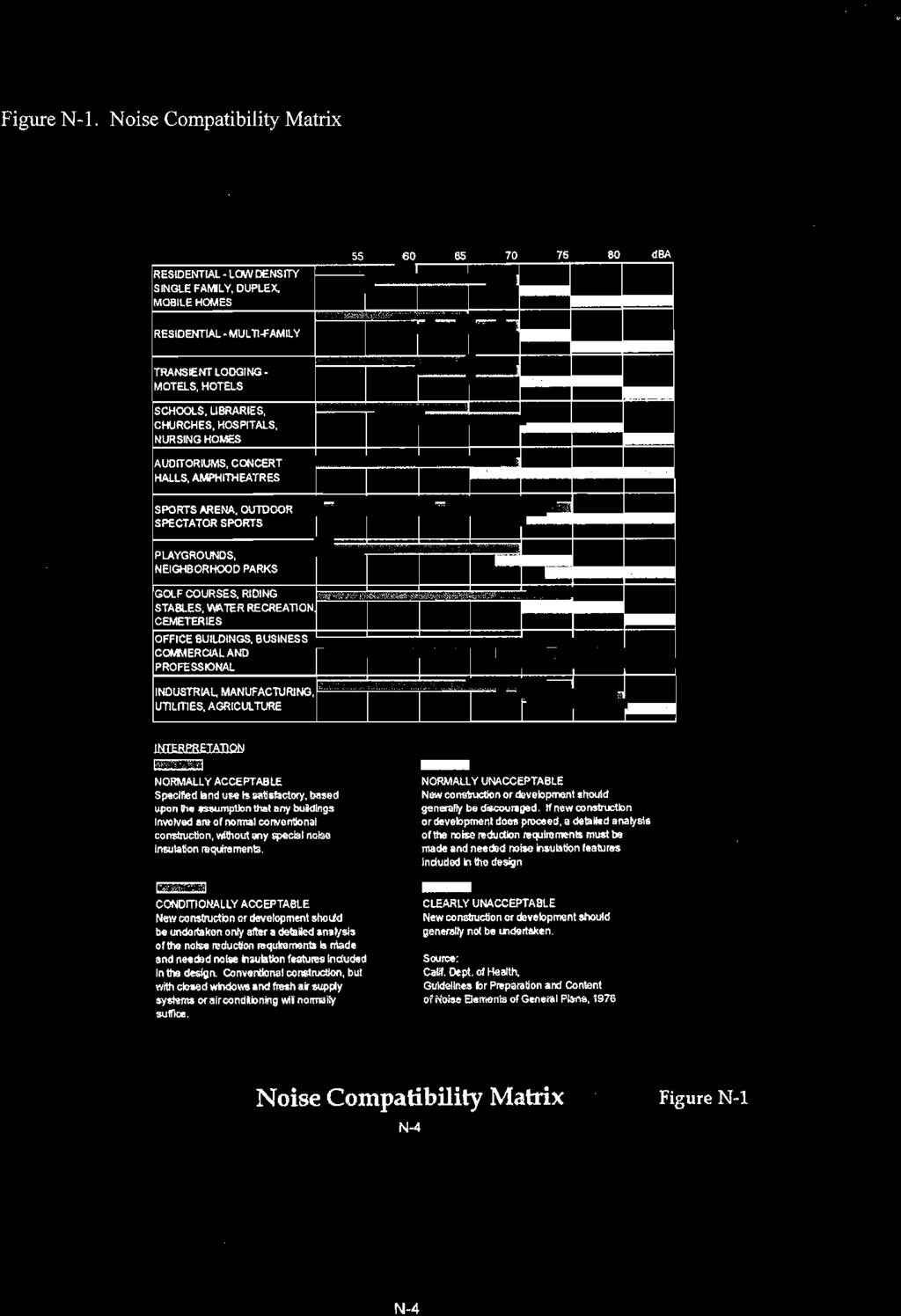
68
69
70
71
72
73
74
75
76
77
78
79
80
81
82
83
84
85
86
87
88


89


90
APPENDIX M CEQA Initial Study Checklist
 APPENDIX M CEQA Initial Study Checklist Appendix G ENVIRONMENTAL CHECKLIST FORM (To be Completed by Applicant) 1. Project title: 2. Lead agency name and address: 3. Contact person and phone number: 4.
City of Bishop. Environmental Checklist Form
 City of Bishop Environmental Checklist Form 1. Project title: Environmental Review / 2007 California Building Codes 2. Lead agency name and address: City of Bishop 377 W. Line Street Bishop, Ca 93514 3.
Draft Negative Declaration of Environmental Impact. Project Title: Environmental Review / Tentative Parcel Map No.388
 Draft Negative Declaration of Environmental Date: August 7, 2008 Subject: Condominium Conversion / 287 East Line Street Project Title: Environmental Review / Tentative Parcel Map.388 Project Proponent:
SECTION 9.0 Effects Found Not To Be Significant
 SECTION 9.0 Effects Found Not To Be Significant 9.0 EFFECTS FOUND NOT TO BE SIGNIFICANT The City of Santa Clarita conducted an Initial Study in April 2006 to determine significant effects of the proposed
Kern County Environmental Checklist Form Environmental Factors Potentially Affected
 Kern County Environmental Checklist Form Environmental Factors Affected The environmental factors checked below would be potentially affected by this project, involving at least one impact that is a potentially
CEQA Impact Key Alta East Wind Energy Project DEIR/DEIS
 CEQA Key Project NI = No ; LTS = Less than Sig; SU = Significant and Unavoidable 4.2 Air AR-1 Conflict with or obstruct implementation of the applicable air quality plan 4.3 Climate Change & Greenhouse
RESOLUTION NO. Resolution No. August 19, 2014 Page 1 of 4
 RESOLUTION NO. A RESOLUTION OF THE CITY COUNCIL OF THE CITY OF SIGNAL HILL, CALIFORNIA, APPROVING NEGATIVE DECLARATION 06/20/14(1), RELATIVE TO ZONING ORDINANCE AMENDMENT 14-02, AMENDMENTS TO TITLE 20
PROPOSED CALIFORNIA ENVIRONMENTAL QUALITY ACT (CEQA) THRESHOLDS OF SIGNIFICANCE
 THRESHOLDS OF SIGNIFICANCE") CITY OF LOS ANGELES DEPARTMENT OF CITY PLANNING PROPOSED CALIFORNIA ENVIRONMENTAL QUALITY ACT (CEQA) THRESHOLDS OF SIGNIFICANCE The City of Los Angeles Department of City Planning proposes adopting these
CITY OF LOS ANGELES DEPARTMENT OF CITY PLANNING PROPOSED CALIFORNIA ENVIRONMENTAL QUALITY ACT (CEQA) THRESHOLDS OF SIGNIFICANCE The City of Los Angeles Department of City Planning proposes adopting these
Draft Mitigated Negative Declaration of Environmental Impact. Subject: Proposed Draft Mitigated Negative Declaration of Environmental Impact
 Draft Mitigated Negative Declaration of Environmental Date: June 17, 2007 Subject: Proposed Draft Mitigated Negative Declaration of Environmental Project Title: Environmental Review / Vons Fuel Center
CITY OF BISHOP DRAFT 2015 ECONOMIC DEVELOPMENT ELEMENT UPDATE
 A DRAFT NEGATIVE DECLARATION CITY OF BISHOP DRAFT 2015 ECONOMIC DEVELOPMENT ELEMENT UPDATE LEAD AGENCY: City of Bishop 377 West Line Street Bishop, CA 93514 Contact: Gary Schley (760) 873-8458 In accordance
City of Eastvale Zoning Code
 INITIAL STUDY FOR A NEGATIVE DECLARATION FOR THE City of Eastvale Zoning Code Lead Agency: CITY OF EASTVALE 12363 Limonite Avenue, Suite 901 Eastvale, CA 91752 December 9, 2011 NOTICE OF PUBLIC HEARING
Environmental Checklist Form
 CITY OF ESCONDIDO Planning Division 201 North Broadway Escondido, CA 92025-2798 (760) 839-4671 Environmental Checklist Form 1. Project title: Downtown Marriott Hotel Project 2. Lead agency name and address:
INSTRUCTIONS ON EVALUATION OF ENVIRONMENTAL IMPACTS
 INSTRUCTIONS ON EVALUATION OF ENVIRONMENTAL IMPACTS 1. A brief explanation is required for all answers except answers that are adequately supported by the information sources a lead agency cites in the
CITY OF SAN MATEO Initial Study
 CITY OF SAN MATEO Initial Study 1. Project Title and Number: Suhl Site Development Permit - PA10-015 2. Lead Agency Name and Address: City of San Mateo, Planning Division 330 W. 20th Avenue, San Mateo,
CITY OF LOS ANGELES OFFICE OF THE CITY CLERK ROOM 615, CITY HALL LOS ANGELES, CALIFORNIA 90012
 CITY OF LOS ANGELES OFFICE OF THE CITY CLERK ROOM 615, CITY HALL LOS ANGELES, CALIFORNIA 90012 CALIFORNIA ENVIRONMENTAL QUALITY ACT INITIAL STUDY AND CHECKLIST (Article IV B City CEQA Guidelines) LEAD
ATTACHMENT A DISCUSSION OF ENVIRONMENTAL FACTORS ARROYO SECO BIKEWAY. a) Have a substantial adverse effect on a scenic vista?
 Have a substantial adverse effect on a scenic vista?") ATTACHMENT A DISCUSSION OF ENVIRONMENTAL FACTORS ARROYO SECO BIKEWAY I. AESTHETICS - Would the proposal: a) Have a substantial adverse effect on a scenic vista? No impact. The proposed project is not within
ATTACHMENT A DISCUSSION OF ENVIRONMENTAL FACTORS ARROYO SECO BIKEWAY I. AESTHETICS - Would the proposal: a) Have a substantial adverse effect on a scenic vista? No impact. The proposed project is not within
Campus Photovoltaic Energy Project at California State University Channel Islands
 Negative Declaration and Initial Study Campus Photovoltaic Energy Project at California State University Channel Islands The Trustees of the California State University Project Proponent: California State
DRAFT INITIAL STUDY/NEGATIVE DECLARATION LEAD AGENCY: CITY OF EL SEGUNDO Planning and Building Safety Department
 DRAFT INITIAL STUDY/NEGATIVE DECLARATION GENERAL PLAN AND ZONE TET AMENDMENT, USES IN THE CORPORATE OFFICE ZONE (EA 1218, GPA 18-01, AND ZTA 18-01) LEAD AGENCY: CITY OF EL SEGUNDO Planning and Building
2018 Kings County Association of Governments RTP/SCS
 2018 Kings County Association of Governments RTP/SCS Initial Study prepared by Kings County Association of Governments 339 West D Street, Suite B Lemoore, California 93245 Contact: Terri King, Executive
Rocking Horse Ridge II Transfer of Territory
 ENVIRONMENTAL REVIEW FOR: Rocking Horse Ridge II Transfer of Territory Prepared by: ORANGE COUNTY COMMITTEE ON SCHOOL DISTRICT ORGANIZATION Contact: Wendy Benkert, Ed.D Secretary to the County Committee
INITIAL STUDY & ENVIRONMENTAL CHECKLIST
 INITIAL STUDY & ENVIRONMENTAL CHECKLIST Project Title Project Location Project Description Lead Agency Contact Biological Resource Policy Update and Oak Resources Management Plan Project El Dorado County
COUNTY OF LOS ANGELES
 COUNTY OF LOS ANGELES DEPARTMENT OF PUBLIC WORKS 900 SOUTH FREMONT AVENUE ALHAMBRA, CALIFORNIA 91803-1331 Telephone: (626) 458-5100 JAMES A. NOYES, Director www.ladpw.org ADDRESS ALL CORRESPONDENCE TO:
PROJECT SITE. Figure 1 Regional and Vicinity Map. Regional Location Map. Scale (Feet)
") PROJECT SITE 118 Northridge 5 210 Regional Location Map 101 North 170 Hollywood Burbank Glendale Pasadena Woodland Hills Toluca Lake PROJECT SITE 134 5 2 2 110 210 405 101 Los Angeles 10 10 60 Santa Monica
PROJECT SITE 118 Northridge 5 210 Regional Location Map 101 North 170 Hollywood Burbank Glendale Pasadena Woodland Hills Toluca Lake PROJECT SITE 134 5 2 2 110 210 405 101 Los Angeles 10 10 60 Santa Monica
Proposed Initial Study/Negative Declaration
 Wireless Telecommunication Facilities Ordinance Proposed Initial Study/Negative Declaration Prepared by: City of Calabasas Planning and Community Development Department 100 Civic Center Way Calabasas,
5.0 LONG-TERM CEQA CONSIDERATIONS
 5.0 LONG-TERM CEQA CONSIDERATIONS Section 15126 of the CEQA Guidelines requires that all phases of a project must be considered when evaluating its impact on the environment, including planning, acquisition,
Ruby Maldonado Project Manager, Planning, OC Development Services
 DATE: January 7, 2016 TO: FROM: Ruby Maldonado Project Manager, Planning, OC Development Services Chris Uzo-Diribe, Planning, OC Development Services SUBJECT: IP15-386 - Addendum IP 15-386 to Negative
CITY OF LOS ANGELES OFFICE OF THE CITY CLERK ROOM 395, CITY HALL LOS ANGELES, CALIFORNIA 90012
 LEAD CITY AGENCY Department of City Planning RESPONSIBLE AGENCIES CITY OF LOS ANGELES OFFICE OF THE CITY CLERK ROOM 395, CITY HALL LOS ANGELES, CALIFORNIA 90012 CALIFORNIA ENVIRONMENTAL QUALITY ACT INITIAL
INITIAL STUDY AND ENVIRONMENTAL REVIEW. Daniel D. Chance, Associate Planner (707) x19
 x19") CITY OF LAKEPORT COMMUNITY DEVELOPMENT DEPARTMENT INITIAL STUDY / ENVIRONMENTAL REVIEW (GPA 16-01,ZC 16-01 and ER 16-01) INITIAL STUDY AND ENVIRONMENTAL REVIEW The application for Amendment of the City
CITY OF LAKEPORT COMMUNITY DEVELOPMENT DEPARTMENT INITIAL STUDY / ENVIRONMENTAL REVIEW (GPA 16-01,ZC 16-01 and ER 16-01) INITIAL STUDY AND ENVIRONMENTAL REVIEW The application for Amendment of the City
The following findings are hereby adopted by The Regents in conjunction with the approval of the Project which is set forth in Section III, below.
 CALIFORNIA ENVIRONMENTAL QUALITY ACT FINDINGS IN CONNECTION WITH THE APPROVAL OF THE EAST CAMPUS STUDENT HOUSING PHASE III DEVELOPMENT PROJECT UNIVERSITY OF CALIFORNIA, IRVINE I. ADOPTION OF THE MITIGATED
INITIAL STUDY AND PROPOSED NEGATIVE DECLARATION FOR THE INYO COUNTY 2015 ACTIVE TRANSPORTATION PLAN
 INITIAL STUDY AND PROPOSED NEGATIVE DECLARATION FOR THE INYO COUNTY 2015 ACTIVE TRANSPORTATION PLAN Prepared for Inyo County Transportation Commission 168 N. Edwards Street Independence, CA 93526 Prepared
INITIAL STUDY CHECKLIST AND PROPOSED MITIGATED NEGATIVE DECLARATION
 Attachment A INITIAL STUDY CHECKLIST AND PROPOSED MITIGATED NEGATIVE DECLARATION Downtown Riverfront Streetcar Project July 2015 Sacramento Area Council of Governments 11415 L Street, Suite 300 Sacramento,
Carpinteria Valley Water District Carpinteria Advanced Purification Project
 NOTICE OF PREPARATION AND SCOPING MEETING Carpinteria Valley Water District Carpinteria Advanced Purification Project TO: Agencies, Organizations, and Interested Parties DATE: January 7, 2019 SUBJECT:
INITIAL STUDY/NOTICE OF PREPARATION ENVIRONMENTAL IMPACT REPORT ORANGE COUNTY WATER DISTRICT PRADO BASIN SEDIMENT MANAGEMENT DEMONSTRATION PROJECT
 INITIAL STUDY/NOTICE OF PREPARATION ENVIRONMENTAL IMPACT REPORT ORANGE COUNTY WATER DISTRICT PRADO BASIN SEDIMENT MANAGEMENT DEMONSTRATION PROJECT Orange County Water District 18700 Ward Street Fountain
APPENDIX A INITIAL STUDY
 City of Los Angeles May 2009 APPENDIX A INITIAL STUDY Draft Environmental Impact Report Technical Appendices Environmental Review Section City Hall 200 N. Spring Street, Room 750 Los Angeles, CA 90012
City of Santa Monica Santa Monica Single-use Carryout Bag Ordinance. Initial Study
 Santa Monica Single-use Carryout Bag Ordinance March 2010 Santa Monica Single-use Carryout Bag Ordinance Prepared by: Office of Sustainability and the Environment 200 Santa Monica Pier, Suite D Santa Monica,
INITIAL STUDY/ NEGATIVE DECLARATION
 INITIAL STUDY/ NEGATIVE DECLARATION INITIAL STUDY/ NEGATIVE DECLARATION Project Title: Lead Agency Name and Address: Project Location: Project Sponsor s Name and Address: General Plan Designation(s): Zoning:
Proposed Mitigated Negative Declaration. Yorba Linda Pump Station Abandonment Project. Fullerton, California. Orange County Sanitation District
 Proposed Mitigated Negative Declaration Yorba Linda Pump Station Abandonment Project Fullerton, California Prepared for Orange County Sanitation District Prepared by December 2014 Initial Study Yorba
CITY OF BISHOP PROPOSED 2012 MOBILITY ELEMENT UPDATE
 DRAFT NEGATIVE DECLARATION CITY OF BISHO ROOSED 2012 MOBILITY ELEMENT UDATE LEAD AGENCY: City of Bishop 377 West Line Street Bishop, CA 93514 Contact: Gary Schley (760) 873-8458 Background, Authority and
EL DORADO COUNTY PLANNING SERVICES 2850 FAIRLANE COURT PLACERVILLE, CA ENVIRONMENTAL CHECKLIST FORM AND DISCUSSION OF IMPACTS
 Project Title: COC05-0164 EL DORADO COUNTY PLANNING SERVICES 2850 FAIRLANE COURT PLACERVILLE, CA 95667 ENVIRONMENTAL CHECKLIST FORM AND DISCUSSION OF IMPACTS Lead Agency Name and Address: El Dorado County,
YOLO COUNTY COMMUNITY SERVICES DEPARTMENT INITIAL STUDY/NEGATIVE DECLARATION
 YOLO COUNTY COMMUNITY SERVICES DEPARTMENT INITIAL STUDY/NEGATIVE DECLARATION RAVINE SPORTS BAR & GRILL USE PERMIT ZONE FILE # 2017-0074 vember 2017 Initial Environmental Study 1. Project Title: Zone File
Environmental Checklist Form
 Environmental Checklist Form 1. Project Title: Change of Zone No. 05-07 (Pre-Zone) and Lotus Ranch Vesting Tentative Subdivision Map 2. Lead Agency Name and Address: City of El Centro 1275 Main Street
APPENDIX A NOP AND COMMENT LETTERS
 APPENDIX A NOP AND COMMENT LETTERS N O T I C E O F P R E P A R A T I O N DATE: December 19, 2005 TO: LEAD AGENCY: SUBJECT: State Clearinghouse, Responsible Agencies, Trustee Agencies, Organizations and
General Plan Housing Element 5 th Cycle Update
 General Plan Housing Element 5 th Cycle Update Initial Study Negative Declaration December 2014 INITIAL STUDY GENERAL PLAN HOUSING ELEMENT 5 TH CYCLE UPDATE Prepared for 100 Civic Center Plaza Lompoc,
Mitigated Negative Declaration. MacArthur Pump Station Rehabilitation Project. Newport Beach, California. Orange County Sanitation District
 Mitigated Negative Declaration MacArthur Pump Station Rehabilitation Project Newport Beach, California Prepared for Orange County Sanitation District Prepared by January 2015 Initial Study MacArthur
TABLE OF CONTENTS. Mitigated Negative Declaration Form/CEQA Initial Study Checklist (front insert) I. INTRODUCTION... I-1 PROJECT DESCRIPTION...
 I. INTRODUCTION... I-1 PROJECT DESCRIPTION...") TABLE OF CONTENTS Mitigated Negative Declaration Form/CEQA Initial Study Checklist (front insert) I. INTRODUCTION... I-1 II. PROJECT DESCRIPTION... II-1 A. PROJECT LOCATION... II-1 B. PROJECT CHARACTERISTICS...
TABLE OF CONTENTS Mitigated Negative Declaration Form/CEQA Initial Study Checklist (front insert) I. INTRODUCTION... I-1 II. PROJECT DESCRIPTION... II-1 A. PROJECT LOCATION... II-1 B. PROJECT CHARACTERISTICS...
CITY OF BANNING Initial Study/Negative Declaration
 CITY OF BANNING Initial Study/Negative Declaration General Plan Amendment and Rezoning Related to Regional Housing Needs Assessment City of Banning Community Development Department 99 E. Ramsey Street
INITIAL STUDY ENVIRONMENTAL CHECKLIST FORM
 DEPARTMENT OF PUBLIC WORKS AND PLANNING STEVEN E. WHITE, DIRECTOR INITIAL STUDY ENVIRONMENTAL CHECKLIST FORM 1. Project title: Initial Study No. 7420 and Unclassified Conditional Use Permit No. 3599 2.
ENVIRONMENTAL REVIEW PROCESS AND ADOPTION OF MITIGATED NEGATIVE DECLARATION
 CALIFORNIA ENVIRONMENTAL QUALITY ACT FINDINGS IN CONNECTION WITH THE APPROVAL OF LANDELS HILL-BIG CREEK NATURAL RESERVE AT THE UNIVERSITY OF CALIFORNIA, LANDELS HILL-BIG CREEK NATURAL RESERVE I. ENVIRONMENTAL
BUTTE COUNTY AIRPORT LAND USE COMMISSION (BCALUC)
") BUTTE COUNTY AIRPORT LAND USE COMMISSION (BCALUC) NOTICE OF PUBLIC HEARINGS AND DOCUMENT AVAILABILITY BUTTE COUNTYAIRPORT LAND USE COMPATIBILITY PLAN (BCALUCP) UPDATE AND ENVIRONMENTAL DOCUMENTS FOR CHICO
BUTTE COUNTY AIRPORT LAND USE COMMISSION (BCALUC) NOTICE OF PUBLIC HEARINGS AND DOCUMENT AVAILABILITY BUTTE COUNTYAIRPORT LAND USE COMPATIBILITY PLAN (BCALUCP) UPDATE AND ENVIRONMENTAL DOCUMENTS FOR CHICO
ADDENDUM. to the FINAL ENVIRONMENTAL IMPACT REPORT. [State Clearinghouse No ]
![ADDENDUM. to the FINAL ENVIRONMENTAL IMPACT REPORT. [State Clearinghouse No ]](/thumbs/95/123669169.jpg "ADDENDUM. to the FINAL ENVIRONMENTAL IMPACT REPORT. [State Clearinghouse No ]") ADDENDUM to the FINAL ENVIRONMENTAL IMPACT REPORT [State Clearinghouse No. 2012061046] for the AMENDED AND RESTATED ALBERHILL VILLAGES SPECIFIC PLAN and DEVELOPMENT AGREEMENT BETWEEN THE CITY OF LAKE ELSINORE
ADDENDUM to the FINAL ENVIRONMENTAL IMPACT REPORT [State Clearinghouse No. 2012061046] for the AMENDED AND RESTATED ALBERHILL VILLAGES SPECIFIC PLAN and DEVELOPMENT AGREEMENT BETWEEN THE CITY OF LAKE ELSINORE
CITY OF EL CENTRO PUBLIC REVIEW NOTICE OF INTENT TO ADOPT NEGATIVE DECLARATION NO
 CITY OF EL CENTRO PUBLIC REVIEW NOTICE OF INTENT TO ADOPT NEGATIVE DECLARATION NO. 14-01 tice is hereby given that a Negative Declaration has been prepared for Change of Zone 14-01 & General Plan Amendment
BUTTE COUNTY AIRPORT LAND USE COMMISSION (BCALUC)
") BUTTE COUNTY AIRPORT LAND USE COMMISSION (BCALUC) NOTICE OF PUBLIC HEARINGS AND DOCUMENT AVAILABILITY BUTTE COUNTYAIRPORT LAND USE COMPATIBILITY PLAN (BCALUCP) UPDATE AND ENVIRONMENTAL DOCUMENTS FOR CHICO
BUTTE COUNTY AIRPORT LAND USE COMMISSION (BCALUC) NOTICE OF PUBLIC HEARINGS AND DOCUMENT AVAILABILITY BUTTE COUNTYAIRPORT LAND USE COMPATIBILITY PLAN (BCALUCP) UPDATE AND ENVIRONMENTAL DOCUMENTS FOR CHICO
CITY OF SAN GABRIEL ENVIRONMENTAL CHECKLIST FORM
 CITY OF SAN GABRIEL ENVIRONMENTAL CHECKLIST FORM 1. Project title: Greening the Code (Planning Case. PL-13-034) 2. Lead agency name and address: City of San Gabriel, 425 S. Mission Drive, San Gabriel,
NEGATIVE DECLARATION. Document Released
 NEGATIVE DECLARATION Pursuant to Division 6, Title 14, Chapter 3, Article 6, Sections 15070 and 15071 of the California Administrative Code and pursuant to the Procedures for Preparation and Processing
Addendum No. 7 to the EIR
 Addendum No. 7 to the EIR San Bernardino County Transportation Authority Redlands Passenger Rail Project SCH No. 2012041012 January 30, 2019 This page is intentionally blank. Contents 1 Purpose and Background...
IV. ENVIRONMENTAL IMPACT ANALYSIS G. HYDROLOGY/WATER QUALITY
 IV. ENVIRONMENTAL IMPACT ANALYSIS G. HYDROLOGY/WATER QUALITY ENVIRONMENTAL SETTING The project site is located in the Wilshire community of the City of Los Angeles and is bound by S. Wetherly Drive to
The Village at Corte Madera Expansion Project
 The Village at Corte Madera Expansion Environmental Report Addendum State Clearinghouse Number: 2016102061 Town of Corte Madera 300 Tamalpais Drive Corte Madera, CA 94925 April 2018 The Village at Corte
Kress Project Environmental Initial Study and Mitigated Negative Declaration. For: Design Review, Conditional Use Permit, and Lot Line Adjustment
 Kress Project Environmental Initial Study and Mitigated Negative Declaration For: Design Review, Conditional Use Permit, and Lot Line Adjustment Owner: David and Collette Kress Saratoga, CA 95070 Public
Mitigated Negative Declaration and Initial Study Student Residence Hall
 Mitigated Negative Declaration and Initial Study Student Residence Hall California State University, Sacramento July 2014 Mitigated Negative Declaration Student Residence Hall California State University,
As noted, the Marblehead EIR included an environmental analysis of a fully operational, approximately 750,000-square-foot regional commercial center,
 Initial Study 1. Project Title: Freeway-Oriented Signage for The Outlets at San Clemente 2. Lead Agency Name and Address: City of San Clemente 100 Avenida Presidio San Clemente, CA 92673 3. Contact Person
City of Temecula Community Development
 December 15, 2011 City of Temecula Community Development Planning Division tice of Preparation And Public Scoping Meeting tice To: Subject: Agencies and Interested Parties tice of Preparation of a Draft
Prado Basin Feasibility Study Initial Study/Notice of Preparation Environmental Impact Report/Environmental Impact Statement
 Prado Basin Feasibility Study Initial Study/Notice of Preparation Environmental Impact Report/Environmental Impact Statement Orange County Water District 18700 Ward Street Fountain Valley, CA 92708 Contact:
Vista Canyon Transit Center - Air Quality Technical Memorandum
 803 Camarillo Springs Road, Suite C Camarillo, California 93012 (805) 437-1900 FAX (805) 437 1901 www.impactsciences.com MEMORANDUM To: Kris Markarian, City of Santa Clarita Job No. 1046.003 From: Susan
RELATED CASES: VTT-63479
 LEAD CITY AGENCY: LOS ANGELES DEPARTMENT OF CITY PLANNING RESPONSIBLE AGENCIES: ENVIRONMENTAL CASE: ENV-2005-7196-MND(REC2) PREVIOUS ACTIONS CASE NO.: PROJECT DESCRIPTION: 81-UNIT RESIDENTIAL CONDOMINIUM
Initial Study and Proposed Negative Declaration for the Alpine County 2010 Regional Transportation Plan
 Initial Study and Proposed Negative Declaration for the Alpine County 2010 Regional Transportation Plan Prepared for the Alpine County Local Transportation Commission Prepared by TRANSPORTATION CONSULTANTS,
Negative Declaration. Westside Pump Station Rehabilitation Project Rossmoor, California. Orange County Sanitation District. Prepared for.
 Negative Declaration Westside Pump Station Rehabilitation Project Rossmoor, California Prepared for Orange County Sanitation District Prepared by 3 Hutton Centre Drive Suite 200 Santa Ana, CA 92707 March
CITY OF MERCED WASTEWATER TREATMENT PLANT EXPANSION PROJECT
 Volume II Appendices CITY OF MERCED WASTEWATER TREATMENT PLANT EXPANSION PROJECT Draft Environmental Report SCH No. 2005101135 Prepared by: City of Merced August 2006 Volume II Appendices CITY OF MERCED
CITY OF LOMPOC ENVIRONMENTAL CHECKLIST FORM
 CITY OF LOMPOC ENVIRONMENTAL CHECKLIST FORM A. PROJECT INFORMATION: Project Title: Housing Authority of the County of Santa Barbara Lead Agency Name and Address: City of Lompoc 100 Civic Center Plaza,
5. OTHER CEQA CONSIDERATIONS
 5. OTHER CEQA CONSIDERATIONS Cumulative Impacts CEQA requires the analysis of impacts due to cumulative development that would occur independent of, but during the same timeframe as, the project under
WHITTIER NARROWS WATER RECLAMATION PLANT DIVERSION
 Draft WHITTIER NARROWS WATER RECLAMATION PLANT DIVERSION Initial Study Prepared for July 2018 Sanitation Districts of Los Angeles County Draft WHITTIER NARROWS WATER RECLAMATION PLANT DIVERSION Initial
INITIAL STUDY SAN DIEGO STATE UNIVERSITY MISSION VALLEY CAMPUS MASTER PLAN PROJECT
 INITIAL STUDY SAN DIEGO STATE UNIVERSITY MISSION VALLEY CAMPUS MASTER PLAN PROJECT Prepared for: The Board of Trustees of the California State University 401 Golden Shore Long Beach, California 90802 Prepared
INITIAL STUDY City of Oceanside California
 INITIAL STUDY City of Oceanside California 1. PROJECT: 2. LEAD AGENCY: City of Oceanside 3. CONTACT PERSON & PHONE: 4. PROJECT LOCATION: 5. APPLICANT: 6. GENERAL PLAN DESIGNATION: 7. ZONING: 8. PROJECT
Initial Study/ Negative Declaration for Olympic Boulevard and Mateo Street Improvements (W.O. E )
") MATEO MATEO ST ST MATEO MATEO ST ST MATEO MATEO ST ST MATEO MATEO MATEO ST ST ST SANTA SANTA FE FE AVE AVE SANTA SANTA SANTA FE FE FE AVE AVE AVE MATEO MATEO MATEO ST ST ST MATEO ST ALLEY ALLEY SANTA SANTA
MATEO MATEO ST ST MATEO MATEO ST ST MATEO MATEO ST ST MATEO MATEO MATEO ST ST ST SANTA SANTA FE FE AVE AVE SANTA SANTA SANTA FE FE FE AVE AVE AVE MATEO MATEO MATEO ST ST ST MATEO ST ALLEY ALLEY SANTA SANTA
North Beach Playground Initial Study/Negative Declaration. March 2017
 City of Santa Monica North Beach Playground Initial Study/Negative Declaration March 2017 Prepared by: City of Santa Monica Planning and Community Development Department 1685 Main Street Santa Monica,
Environmental Initial Study Parks Master Plan City of La Mesa, County of San Diego, CA
 Environmental Initial Study Parks Master Plan City of La Mesa, County of San Diego, CA Lead Agency: City of La Mesa 4975 Memorial Drive La Mesa, CA 91942 619-667-1308 Contact: Mike Pacheco, Project Manager
CEDARS-SINAI MEDICAL CENTER WEST TOWER PROJECT ENV EIR APPENDIX A NOTICE OF PREPARATION INITIAL STUDY PUBLIC SCOPING COMMENTS
 CEDARS-SINAI MEDICAL CENTER WEST TOWER PROJECT ENV 2008-0620-EIR APPENDIX A NOTICE OF PREPARATION INITIAL STUDY PUBLIC SCOPING COMMENTS CEDARS-SINAI MEDICAL CENTER WEST TOWER PROJECT ENV 2008-0620-EIR
CITY OF MALIBU NOTICE OF INTENT TO ADOPT A NEGATIVE DECLARATION
 CITY OF MALIBU NOTICE OF INTENT TO ADOPT A NEGATIVE DECLARATION Notice is hereby given that the City of Malibu has completed an Initial Study for the following project in accordance with the California
MAMMOTH COMMUNITY WATER DISTRICT Initial Study/Mitigated Negative Declaration
 MAMMOTH COMMUNITY WATER DISTRICT Initial Study/Mitigated Negative Declaration Pursuant to the California Environmental Quality Act and CEQA Guidelines, the Mammoth Community Water District proposes to
County o Fresno is Times New DRADRAFT NOTICE OF DETERMINATION
 County o Fresno is Times New DRADRAFT NOTICE OF DETERMINATION DEPARTMENT OF PUBLIC WORKS AND PLANNING STEVEN E. WHITE, DIRECTOR To: Office of Planning and Research County Clerk, County of Fresno 1400 Tenth
2030 General Plan. November 1, :00 p.m.
 2030 General Plan GPAC Meeting #7 November 1, 2007 7:00 p.m. Planning Commission Review of Land Use Map Planning Commission concurred with most GPAC recommendations Exceptions include: Consider area along
APPENDIX A: A.1: Santa Monica Community College District Notice of Preparation and Scoping Meeting for the Santa Monica College Malibu Campus Project
 APPENDIX A: A.1: Santa Monica Community College District Notice of Preparation and Scoping Meeting for the Environment Report, dated May 17, 2012. A.2: Santa Monica Community College District California
CITY OF BEVERLY HILLS SOUTH CARSON ROAD REZONE PROJECT INITIAL STUDY
 CITY OF BEVERLY HILLS 128-130 SOUTH CARSON ROAD REZONE PROJECT INITIAL STUDY Table of Contents Initial Study 1. Project title:... 3 2. Lead agency name and address:... 3 3. Contact person and phone number:...
CITY OF MERCED WASTEWATER TREATMENT PLANT EXPANSION PROJECT
 Volume II Appendices CITY OF MERCED WASTEWATER TREATMENT PLANT EXPANSION PROJECT Draft Environmental Impact Report SCH No. 2005101135 Prepared by: City of Merced August 2006 Volume II Appendices CITY
DRAFT NEGATIVE DECLARATION OF ENVIRONMENTAL IMPACT AND INITIAL STUDY
 Planning Department 168 North Edwards Street Post Office Drawer L Independence, California 93526 Phone: (760) 878-0263 FAX: (760) 878-0382 E-Mail: inyoplanning@ Inyocounty.us DRAFT NEGATIVE DECLARATION
Inglewood Oil Field Specific Plan Project Draft Environmental Impact Report
 Draft Environmental Impact Report SCH No. 2015101030 Prepared for: City of Culver City Planning Division 9770 Culver Boulevard Culver City, California 90232 Prepared by: Psomas 225 South Lake Avenue Suite
TABLE OF CONTENTS. Mitigated Negative Declaration Form/CEQA Initial Study Checklist (front insert) I. INTRODUCTION... I-1 PROJECT DESCRIPTION...
 I. INTRODUCTION... I-1 PROJECT DESCRIPTION...") TABLE OF CONTENTS Mitigated Negative Declaration Form/CEQA Initial Study Checklist (front insert) I. INTRODUCTION... I-1 II. PROJECT DESCRIPTION... II-1 A. PROJECT LOCATION... II-1 B. PROJECT CHARACTERISTICS...
TABLE OF CONTENTS Mitigated Negative Declaration Form/CEQA Initial Study Checklist (front insert) I. INTRODUCTION... I-1 II. PROJECT DESCRIPTION... II-1 A. PROJECT LOCATION... II-1 B. PROJECT CHARACTERISTICS...
Appendix A Initial Study/NOP and NOP Comment Letters
 Appendix A Initial Study/NOP and NOP Comment Letters City of Long Beach Riverwalk Residential Development Project Draft Initial Study Notice of Preparation September 2014 RIVERWALK RESIDENTIAL DEVELOPMENT
NOTICE OF PREPARATION DUBLIN HIGH SCHOOL ENGINEERING & SCIENCE BUILDING AND INTERIM HOUSING PHASE 1B ENVIRONMENTAL IMPACT REPORT
 NOTICE OF PREPARATION DUBLIN HIGH SCHOOL ENGINEERING & SCIENCE BUILDING AND INTERIM HOUSING PHASE 1B ENVIRONMENTAL IMPACT REPORT To: State Clearinghouse Governor s Office of Planning & Research Responsible
The Resort at Los Coyotes
 The Resort at Los Coyotes CEQA Checklist City of Buena Park March 27, 2013 DATE FILED: March 27, 2013 General Information: 1. Name, address, and phone number of project developer/sponsor: McAuley LCX 8888
City of Long Beach Adult Use Cannabis Regulations
 Adult Use Cannabis Regulations Initial Study and Negative Declaration ND 13-17 Prepared by: Department of Development Services Planning Bureau Adult-Use Cannabis Regulations INITIAL STUDY Project Title:
INITIAL STUDY/MITIGATED NEGATIVE DECLARATION
 INITIAL STUDY/MITIGATED NEGATIVE DECLARATION BOULDER AVENUE BRIDGE REPLACEMENT PROJECT CITY OF HIGHLAND SAN BERNARDINO COUNTY, CALIFORNIA December 11, 2008 INITIAL STUDY/MITIGATED NEGATIVE DECLARATION
On the basis of this initial evaluation, the Environmental Coordinator finds that:
 COUNTY OF SAN LUIS OBISPO INITIAL STUDY SUMMARY - ENVIRONMENTAL CHECKLIST (ver 2.1) Project Title & No. ALUP Amendment for Paso Robles Airport ED06-299 ENVIRONMENTAL FACTORS POTENTIALLY AFFECTED: The proposed
CEQA and Health Effects
 CEQA and Health Effects (as of early 2015) JIM MOOSE REMY MOOSE MANLEY LLP ASSOCIATION OF ENVIRONMENTAL PROFESSIONALS 2015 STATE CONFERENCE SANTA BARBARA MARCH 24, 2015 CEQA and Health Effects Overall
November 2006 NOP and IS
 November 2006 NOP and IS NOTICE OF PREPARATION TO: Distribution List (Attached) Lead Agency: Consulting Firm: Agency Name: City of Santa Clarita Name: Sciences Street 23920 Valencia Boulevard, Street Address:
APPENDIX A. Notice of Preparation (NOP) and Initial Study
 and Initial Study") APPENDIX A Notice of Preparation (NOP) and Initial Study SANTA MONICA COLLEGE CALIFORNIA ENVIRONMENTAL QUALITY ACT (CEQA) INITIAL STUDY CHECKLIST PROJECT TITLE DATE: September 22, 2009 LEAD AGENCY:
APPENDIX A Notice of Preparation (NOP) and Initial Study SANTA MONICA COLLEGE CALIFORNIA ENVIRONMENTAL QUALITY ACT (CEQA) INITIAL STUDY CHECKLIST PROJECT TITLE DATE: September 22, 2009 LEAD AGENCY:
SECTION 6.0 Alternatives to the Proposed Project
 SECTION 6.0 Alternatives to the Proposed Project 6.0 ALTERNATIVES TO THE PROPOSED PROJECT CEQA requires that an EIR include an analysis of a range of project alternatives that could feasibly attain most
RIVERSIDE COUNTY ENVIRONMENTAL ASSESSMENT FORM: INITIAL STUDY
 RIVERSIDE COUNTY ENVIRONMENTAL ASSESSMENT FORM: INITIAL STUDY Environmental Assessment (E.A.) Number: EA38725 Project Case Type (s) and Number(s): CZ6699, PM30525, CUP3378 Lead Agency Name: County of Riverside
2. Surrounding Uses F I G U R E 3: SECTION II. PROJECT DESCRIPTION PAGE II-3
 SECTION II. PROJECT DESCRIPTION PAGE II-3 2. Surrounding Uses An aerial photograph from Google Earth (2016) shows adjacent agricultural industrial uses south and east of the project. Agricultural uses
INITIAL STUDY Environmental Checklist and Evaluation for Santa Clara County
 INITIAL STUDY Environmental Checklist and Evaluation for Santa Clara County File Number: 10061-00-00-09Z Date: September 10, 2010 Project Type: Zoning Ordinance Update APN(s): Multiple Project Location
Incremental Recycled Water Program 2007 ADDENDUM TO PROGRAM ENVIRONMENTAL IMPACT REPORT
 SANTA ROSA SUBREGIONAL WATER REUSE SYSTEM Incremental Recycled Water Program 2007 ADDENDUM TO PROGRAM ENVIRONMENTAL IMPACT REPORT SCH #2002072046 March 2007 SANTA ROSA SUBREGIONAL WATER REUSE SYSTEM 2007