Community Resources and Potential Hazards
|
|
|
- Amy Bradford
- 6 years ago
- Views:
Transcription
 Waste Management and Recycling Natural")
1 C H A P T E R E I G H T Community Resources and Potential Hazards Introduction This chapter of the General Plan sets forth the City s goals, policies and implementing actions for Community Resources and Potential Hazards, including: Open Space and Habitat Areas Air Quality Water Quality Natural Resource Conservation (water, energy, and mineral resources) Waste Management and Recycling Natural Hazards (seismic, soils and geology, fire, flooding) Noise Hazardous Materials Revised February 2017 Gilroy General Plan 8-1
2 Goals and Policies 20 Open Space and Habitat Areas GOAL: Preservation, protection, and maintenance of Gilroy s natural open space resources (including creeks, meadows, hills, woodlands, and vistas) for their watershed protection, habitat preservation, recreation, and aesthetic value, ensuring that they retain their natural qualities and beauty in perpetuity. Actions 20.A thru 20.J Open Space and Habitat Areas Policy Open Space Areas. Preserve and protect the following open space areas: a) Natural resource and wildlife habitat areas, such as the Uvas Creek and Llagas Creek riparian communities; the heavily vegetated portions of the Santa Cruz mountains; steep hillsides and significant hillside features (such as serpentinite barrens); and natural features of high community value (e.g., the stands of trees along Miller Avenue and cedar trees bordering Hecker Pass). b) Hazardous areas, such as fault zones, areas subject to strong groundshaking during earthquakes, and floodways. c) Lands around reservoirs. d) Lands which provide greenbelts for the South County cities. e) Recreational lands, including community, neighborhood, and linear parks; expanded linear parks along Uvas and Llagas Creek; and the Gilroy Municipal Golf Course. Action 20.B Creek Protection Policy Creek Protection. Protect the ecological, aesthetic and recreational value of the creeks that flow through the Gilroy Planning Area from urban encroachment and degradation. Ensure that new development preserves the function of natural drainages, including small canyons and seasonal creeks. The easements and setbacks adjacent to these creeks shall be maintained in open space. Access to creeks should be of sufficient width to accommodate trails, flood control access, and protection of riparian habitat. 8-2 Gilroy General Plan Revised February 2017
3 Policy Plant and Wildlife Habitats. Preserve important plant and wildlife habitats, including riparian communities, heavily vegetated hillside areas, unique hillside ecosystems (e.g., serpentinite barrens), creeks, and sensitive nesting sites. Loss of these habitats should be fully offset through creation of habitat of equal value, with the compensation rate for habitat creation determined by a qualified biologist. Action 20.C Habitat Protection Ordinance Action 20.D Consultation on Fish and Wildlife Impacts Policy Rare and Endangered Species. Limit development in areas that support the California Tiger Salamander and other rare or endangered species. If development of these areas must occur, any loss of habitat should be fully compensated onsite. If off-site mitigation is necessary, it should occur within the Gilroy Planning Area whenever possible, and must be accompanied by plans and a monitoring program prepared by a qualified biologist. Policy Greenbelts. Designate protected open space areas in conjunction with agricultural lands to create significant natural buffers, or greenbelts, between Gilroy and surrounding communities, helping to retain the city s semi-rural, small town quality. Land uses within a greenbelt should be determined by joint planning activities of the South County cities and the County, but might include very low density residential development; public parks and recreation areas; privately operated recreation areas; and agriculture. Of special concern is the area separating the northern part of the Gilroy Planning Area from the community of San Martin. If an adequate greenbelt cannot be established in the area north of Masten and Fitzgerald Roads, then the Gilroy General Plan Land Use Map should be amended to include a greenbelt strip in the northern part of the Planning Area. Action 20.C Habitat Protection Ordinance Action 20.D Consultation on Fish and Wildlife Impacts Action 20.E Greenbelt Definition and Protection Action 20.F Gilroy-San Martin Greenbelt Policy Open Space Access and Management. Manage and maintain public open space areas and encourage the management and maintenance of private open space areas in a manner that ensures habitat protection, provides for public access, addresses public safety concerns, and meets low-impact recreation needs. Action 20.G Open Space Access Action 20.H Open Space Management Revised February 2017 Gilroy General Plan 8-3
4 Action 20.I Open Space Preservation Tools Action 20.J Santa Clara County Open Space District Policy Preservation Techniques. Develop and apply a variety of preservation tools to protect open space in and around the City. These might include: a) Public acquisition b) Land use regulation c) Planning and urban development policies d) Economic incentives to landowners e) Open space easements f) Transfer of development rights g) Planned cluster development h) Assessment districts i) Dedication of additional lands upon development In the selection and application of preservation methods, emphasis should be given, in no particular order, to (1) minimizing public costs and liability exposure; (2) consideration of long-term management and maintenance issues; (3) consideration of public access issues; and (4) ensuring preservation in perpetuity. Action 20.I Open Space Preservation Tools Action 20.J Santa Clara County Open Space District Policy Open Space Areas and the Parks and Recreation System. Open space areas have important community value, but may have limited or no recreational value due to public safety and access issues. While preservation of these lands should be strongly encouraged, they should not be dedicated as part of the City s Parks and Recreation System, due to long-term management and liability issues, unless a recreational value can be demonstrated consistent with the Parks and Recreation Facility Classification System (page 7-9). Participation in the Santa Clara County Open Space Authority, and dedication of these open space lands to the Authority or other public agencies, should be further explored as a means of ensuring longterm preservation and management of non-recreational open space. Land owners who prefer not to dedicate open space land to a public agency are encouraged to consider land dedication to a private land trust such as the Land Trust for Santa Clara County. Action 20.I Open Space Preservation Tools Policy Preservation in Perpetuity. When open space easements, dedications or other land preservation measures are required as a condition of project approval, ensure that dedicated lands are preserved in perpetuity. 8-4 Gilroy General Plan Revised February 2017
5 Policy Regional Preservation Efforts. Support and participate in regional open space preservation programs and efforts to (a) establish policies and implementation plans for greenbelts between the South County cities; and (b) to identify and help establish a viable source of funding for acquiring and developing regional parks, pathways, and open space. Action 20.E Greenbelt Definition and Protection Action 20.I Open Space Preservation Tools Action 20.J Santa Clara County Open Space District 21 Air Quality GOAL: Achievement of federal and state air quality standards by managing locally generated pollutants, coordinating with other jurisdictions, and implementing land use and transportation measures to reduce automobile trips and congestion, encouraging more walking, biking, and transit use. Policy Sensitive Receptors. Use land use planning and project siting to separate air pollution sources (such as freeways, arterials, industrial sites, etc.) from residential areas and other sensitive receptors (such as schools, hospital, and nursing homes) that would be adversely affected by close proximity to air pollutants. Policy Landscaping to Reduce Pollutants. Promote the use of trees and plants in landscaping to reduce air pollutant levels. Policy Trip Reduction and Congestion Management. Reduce the frequency and length of automobile trips and the amount of traffic congestion by controlling urban sprawl, promoting infill development, and encouraging higher density development with access to public transit. Also, promote mixed use developments that locate support services such as day care, restaurants, banks, and stores within walking distance of employment centers, and neighborhood-serving uses such as parks, day care, small-scale stores, and cafes within walking distance of residential developments. Policy Regional Collaboration. Cooperate with the Bay Area Air Quality Management District and other agencies that deal with issues related to air quality (e.g., the Metropolitan Transportation Commission and the Association of Bay Area Govern- Land Use Plan Map Action 21.A Air Quality Mitigation Action 1.I Community Beautification Action 21.A Air Quality Mitigation see also Chapter 6, Transportation and Circulation Ongoing implementation by City staff Revised February 2017 Gilroy General Plan 8-5
6 ments) to develop and implement regional air quality strategies. Also, support subregional coordination with other cities, counties and agencies in Santa Clara Valley and adjacent areas to address land use, jobs/housing balance, and transportation planning issues as a means of improving air quality. Action 21.B Emission Reductions for Construction-Related Equipment Action 12.J Signal Timing Action 13.D Signal Preemption for Buses Action 14.K Bicycle and Pedestrian Improvements Action 21.C Implementing the Clean Air Plan Action 22.A Comprehensive Groundwater Management Program Action 22.B Water Quality Ordinances, Standards and Enforcement Procedures Policy Air Quality Impacts from Construction Activity. Reduce the air quality impacts associated with construction activity by reducing the exhaust emissions through appropriate mitigation actions. Policy Traffic Control Measures. Implement the Transportation Control Measures recommended by the Bay Area Air Quality Management District in the 2000 Clean Air Plan to reduce pollutant emissions. 22 Water Quality GOAL: Protection of groundwater in the Llagas subbasin from contamination and a clean and healthy supply of potable water in compliance with State and Federal water quality standards. Policy Inter-Agency Coordination. Maintain close coordination with the agencies and organizations that share jurisdiction and interest relative to South County s water supply and water quality, including: the Regional Water Quality Control Board; Santa Clara Valley Water District; County Health Department; County Executive s Office; County Planning Office; Morgan Hill Planning Department; and the San Martin Planning Committee. Policy Compatible Ordinances, Standards, and Enforcement Procedures. Ensure compatible ordinances, standards, and enforcement procedures regarding water quality in all South County jurisdictions so that there is no advantage for a company to locate in an area with lower standards. Also, encourage the two Regional Water Quality Control Boards that have jurisdiction in South County to agree on compatible water quality standards for South County and consistent approaches to implementing the State Board s non-degradation policy. 8-6 Gilroy General Plan Revised February 2017
7 Policy Land Use Controls. Prohibit development of waste facilities, septic systems, and industries using toxic chemicals in areas where polluting substances may come in contact with groundwater, floodwaters, creeks, or reservoir waters. Within the Gilroy Planning Area, identify land uses that may contribute to the degradation of groundwater quality and ensure adequate monitoring, controls and enforcement to protect groundwater quality. Action 22.A Comprehensive Groundwater Management Program Policy Drinking Water Quality. Ensure that City drinking water exceeds the required and recommended standards set forth by the State of California Department of Environmental Protection. Policy Water Quality Monitoring. Continue to monitor groundwater and surface water quality conditions to ensure that water quality standards are being maintained and to determine if changes in regulations regarding septic systems and land use are needed. Provide monitoring results to a central agency that will coordinate the data and make it available to all jurisdictions and agencies. Policy Private Well Monitoring. Continue to monitor private wells and expand the scope of testing to include tests of more wells, tests on constituents not yet tested in private wells (i.e., volatile organics, bacteriological, radiological, etc.), and periodic retesting of selected private wells. Policy Abandoned and Unused Wells. Continue programs to identify and seal abandoned and unused wells, as such wells may be prime sources for transferring contaminants from the upper to the lower aquifer. Policy Septic Systems. Continue land use policies that limit the number of individual septic systems in areas vulnerable to groundwater contamination because of the potential for cumulative degradation of water quality. Action 22.C Water Quality Monitoring Program Action 22.C Water Quality Monitoring Program Action 22.C Water Quality Monitoring Program Action 22.D Abandoned and Unused Wells Program Action 22.A Comprehensive Groundwater Management Program Revised February 2017 Gilroy General Plan 8-7
8 Action 22.A Comprehensive Groundwater Management Program Action 22.A Comprehensive Groundwater Management Program Policy High Percolation Soils. Restrict development on properties that have soils with rapid water percolation to protect water quality. Commercial and industrial developments in such areas shall only be permitted under the strict safety limitations required by the City s and/or County s Hazardous Materials Specialists. Policy Groundwater Recharge Areas. To provide greater protection of the aquifers that supply drinking water to South County, give special consideration to the management of contaminants (e.g., hazardous materials, sanitary effluents) in groundwater recharge areas where no protective aquitard layer exists. 23 Natural Resource Conservation GOAL: Conservation of natural resources and high levels of environmental quality for current and future generations. Action 23.A Water Reclamation Program Action 23.B Water Conservation Education Program Policy Water Conservation and Reclamation. Promote water conservation and encourage the use of reclaimed or recycled water to reduce the overall demand on water resources. Ensure that recycled wastewater is treated in accordance with state and federal standards. Action 23.A Water Reclamation Program Policy Water Reclamation Facilities. Encourage development of water reclamation facilities, where feasible, in order to make reclaimed water available to help meet the growing water needs of the South County region. Action 23.B Water Conservation Education Program Action 23.A Water Reclamation Program Policy Drought-Resistant Landscaping. Encourage the use of drought-resistant landscaping and low-flow irrigation systems to help reduce overall demand. Policy Irrigation with Reclaimed Water. Use reclaimed water for landscape irrigation, especially for large water users such as golf courses. 8-8 Gilroy General Plan Revised February 2017
9 Policy Energy Conservation. Reduce energy consumption through appropriate building technologies, promotion of non-auto transportation modes, support for greater use of alternative energy sources, and dissemination of public information regarding energy conservation techniques. Policy Mineral Resources. Conserve the mineral resources along Uvas Creek that have been designated by the State Mining and Geology Board as having statewide or regional significance. Protect these resource areas from urban encroachment and premature development that may be incompatible with mining. Undeveloped lands that may be recognized in the future as possessing mineral resources of statewide or regional significance shall also be examined to determine the feasibility of conserving those lands for future mineral extraction. Action 23.C Energy Efficiency Standards Action 23.D Energy Conservation Information Action 23.E Alternative Energy Ordinance Action 23.F Mineral Resource Area Designations Action 23.G Mineral Resource Mining Operations Action 23.H Mineral Resource Status Termination 24 Waste Management and Recycling GOAL: Cooperation with South Valley Disposal and Recycling, the County and other South County cities to address potential landfill capacity issues; continued implementation of waste-reduction activities; and increased recycling to meet the State-mandated reduction in the City s waste stream. Policy Recycling. Enhance the long-term viability of natural resources and reduce the volume of material sent to solid waste sites by continuing source reduction and recycling programs, encouraging the participation of all residents and businesses. Action 24.A Source Reduction and Recycling Element Policy Source Reduction. Reduce the volume of disposed waste by encouraging efforts to decrease consumption; reduce material weight and volume; reuse products and materials; and increase the durability of products and materials. Action 24.A Source Reduction and Recycling Element Policy Landfill Siting. As the current Pacheco Pass landfill nears capacity, ensure that a new landfill site is designated to meet the City s medium- to long-term waste disposal needs. Action 24.B Landfill Siting Process Revised February 2017 Gilroy General Plan 8-9
10 25 Natural Hazards GOAL: (a) Minimal potential for loss of life, injury, damage to property, economic and social dislocation, and unusual public expense due to natural hazards. (b) Development and use controls to protect the public from the risk of flood damage and to minimize hazards posed by fire, seismic activity, geologic instability, soil erosion, weak and expansive soils, and potentially hazardous soils materials. Action 25.A Hazards Maps Action 25.H Ordinance Regulating Development in Very High Fire Hazard Severity Zones Action 25.M Flood Control Ordinance Action 1.A Zoning Ordinance Action 25.A Hazards Maps Action 25.A Hazards Maps Action 25.B Building Codes Action 25.G Fire Safety Plan Checks Action 25.B Building Codes Policy Location of Future Development. Permit development only in those areas where potential danger to the health, safety, and welfare of residents can be adequately mitigated to an acceptable level of risk (see Policy 25.04). This applies to development in areas subject to flood damage or geological hazard due to their location and/or design. Development should be prohibited in areas where emergency services, including fire protection, cannot be provided. Policy Zoning and Development Regulations. Use zoning and other land use and development controls to regulate development in hazardous areas. Such restrictions should be determined based on the potential degree of hazard involved and the potential public costs that would be incurred in the event of an emergency. Policy Development Review. Require appropriate studies as part of the development review process to assess potential hazards and assure that impacts are adequately mitigated. Policy Acceptable Risk. Enact development controls to ensure an acceptable level of risk in those areas where life and property are subject to seismic, geologic, and flooding hazards. Acceptable risk in this instance describes the level of risk that the majority of citizens will accept without expecting governmental action to provide protection. This definition considers acceptable risk only from the point of view of the public agency; individual concepts of acceptable risk may vary widely. Levels of acceptable risk and damage related to kind of facility and occupancy are presented in Figure Gilroy General Plan Revised February 2017
11 Figure 8-1. Levels of Acceptable Risk and Damage Related to Kind of Facility and Occupancy Level of Acceptable Risk Near Zero Extremely Low Low Kinds of Structure Highly Critical Structures and Occupancies Structures whose continued functioning is critical, or whose failure might be catastrophic: large dams, power/energy systems, plants with explosive, toxic or highly flammable materials. Examples: Anderson Reservoir Dam, electric transmission lines, natural gas transmission lines. Structures Critically Needed After Disaster Structures the use of which is critically needed after a disaster: important utility centers; hospitals; fire, police, and emergency communication facilities; critical transportation facilities, such as bridges and overpasses; and smaller dams. Examples: South Valley Hospital, fire stations, City Hall, Uvas Reservoir Dam, Highways 101 and 152, major railroad crossings, electrical substations, etc. High Occupancy Structures Structures of high occupancy, or whose use after a disaster would be particularly convenient: schools, churches, theaters, large hotels, and other high-rise buildings housing large numbers of people, other places normally attracting large concentrations of people, civic buildings, secondary utility structures, extremely large commercial enterprises, most roads, alternative or non-critical bridges and overpasses. Acceptable Damage None of which would expose large population to death or serious injury or impair the safety of the facility or disrupt its function. Minor non-structural; facility should remain operational and/or be susceptible to quick restoration or service. No structural damage which would materially impair safety; strutures should remain usable; some impairment of function acceptable. Ordinary Ordinary Risk Tolerance The vast majority of structures in urban areas, including most commercial, industrial and residential buildings that don t fall into one of the preceding categories. Buildings should be able to: a) resist minor earthquakes without damage; b) resist moderate earthquakes without structural damage, but with non-structural damage; c) resist major earthquakes, of the intensity and severity of the strongest experienced in California, without collapse, but with some structural as well as non-structural damage. Moderate to High Moderate to High Risk Tolerance Open space uses, such as farms, ranches, and parks without high occupancy structures; warehouses with low intensity employment storing non-hazardous materials. Structures for human occupancy should meet the damage criteria specified for the ordinary risk class, except where occupancy is high, which case the low risk criteria apply. Revised February 2017 Gilroy General Plan 8-11
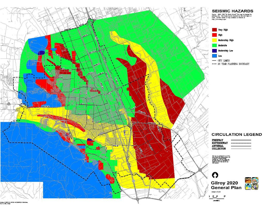
12 Seismic Policy Definition of Active Faults. Consider all faults in the area to be active faults, unless and until evidence to the contrary is developed through field investigation. Action 25.A Hazards Maps Policy Seismic Hazards Map. Use the Seismic Hazards Map to identify areas of potential seismic risk. Update the map and related data as necessary to reflect the most recent and accurate geologic data, in accordance with the State of California s Seismic Hazards Mapping Act. Action 25.A Hazards Maps Action 25.B Building Codes Action 25.B Building Codes Action 25.C Building Inspection Action 25.E Soils Reports Policy Development in Seismic Risk Areas. Allow only low intensity, low occupancy development in areas subject to high seismic risk. Policy Structural Standards. Assure that structures for human occupancy are designed and constructed to retain their structural integrity when subjected to seismic activity in accordance with the Uniform Building Code of the State of California. Policy Site Investigation and Mitigation. Ensure proper site investigation and appropriate mitigation for development proposals in areas of unconsolidated fill, in former streambeds, and in areas subject to seasonal high groundwater tables. Site and building design and engineering must minimize potential damage to an acceptable level of risk from hazards posed by liquefaction, differential settlement, and severe ground shaking. ongoing implementation by City and other agency staff Policy Roads, Bridges, and Utility Lines. Ensure that the design and engineering of new roads, bridges and utility lines (public and private) that cross active or potentially active fault traces, streams, or other areas of high seismic risk respond to the potential hazards posed by movement or ground failure along these corridors. Equip water, gas, and electric lines with shut-off devices which utilize the best technology for quick shut-off consistent with providing reliable service. Also, ensure that new water storage tanks are constructed and anchored to prevent toppling and displacement during periods of strong seismic activity Gilroy General Plan Revised February 2017

13 Soils and Geology Policy Slope Restrictions. Restrict development on steep slopes and on slopes susceptible to landslides and soil creep. Slopes of 10 to 30 percent may be suitable for low intensity, low density development, subject to site-specific review and approval. Slopes greater than 30 percent, areas of high landslide risk, and areas with highly expansive soils on slopes greater than 10 percent are not suitable for development and will remain open space. Action 25.E Soils Reports Action 25.F Erosion and Deposition Control Fire Policy Very High Fire Hazard Severity Zone. Restrict development in the Very High Fire Hazard Severity Zone (or Mutual Threat Zone ) as designated by the South Santa Clara County Fire Protection District and illustrated in Figure 8-2. Action 25.H Ordinance Regulating Development in Very High Fire Hazard Severity Zones Figure 8-2. Very High Fire Hazard Severity Zone, or Mutual Threat Zone Revised February 2017 Gilroy General Plan 8-13
14 Action 25.G Fire Safety Plan Checks Action 25.I Fire and Life Safety Inspections Action 25.J Fire Hazard Abatement Action 25.G Fire Safety Plan Checks Action 25.I Fire and Life Safety Inspections Policy Fire Prevention and Hazard Reduction. Ensure that new and existing construction complies with applicable State and local codes, ordinances and regulations regarding fire and life safety. Policy Roofing Requirements. Require Class A roofs on all new construction or reroofing in the area west of Santa Teresa Boulevard, south of Mantelli Drive, and west of Rancho Hills Drive. In all other areas, Class C roofs shall be required for new construction and re-roofing. Action 19.C Water Master Plan Action 25.G Fire Safety Plan Checks Action 1.B Hillside Development Guidelines Policy Water Flows for Fire Suppression. Ensure adequate water flows in all areas of urban development to provide the level of fire suppression necessary for the types of structures and occupancies anticipated. Limit new development to areas where adequate flows for fire suppression are provided, and require improvement measures in existing subdivided areas to where flows are insufficient. Policy Hillside Areas. Require developments in hillside areas to comply with the fire hazard policies of the Hillside Development Guidelines and the criteria set forth on the Plan Checklist for Hillside Construction of the Gilroy Fire Department. Flooding Ongoing implementation by City staff Policy Flood Control Coordination. Work closely with the Santa Clara Valley Water District to alleviate flooding and drainage problems in the Planning Area, ensuring that new flood control measures are designed and implemented in accordance Best Management Practices (BMPs) and in keeping with the goals and policies of the General Plan. Action 25.M Flood Control Ordinance Policy Development Restrictions in Flood Areas. Restrict urban development and expansion in areas prone to flooding (as indicated on the Flood Hazards Map) or on properties where drainage problems or saturated soil conditions create flood hazards. Allow development in such areas only if measures are enacted to reduce these hazards to an acceptable level of risk Gilroy General Plan Revised February 2017
15 Policy Floodway Use. Discourage the construction of expensive flood prevention facilities by leaving high-risk floodways in agricultural and recreational uses. Policy Flood Control Costs and Impacts. Minimize the long-term public costs of flood control improvements and mitigate potential adverse environmental impacts. Also ensure that measures to reduce flood damage to individual properties do not increase erosion and/or flood hazards on other properties. Land Use Plan Map Action 25.M Flood Control Ordinance Action 25.M Flood Control Ordinance Policy Multiple Use of Flood Control Projects. Design flood control measures and drainage channel improvements as part of an overall community improvement program with provision for multiple use, including recreational open space, trails, bikeways, groundwater recharge, protection and restoration of riparian vegetation and wildlife habitats, and enhancement of scenic qualities. Policy Drainage Channel Design. Design new drainage channels with gently sloping and curving banks to maximize safety, ease of maintenance, and natural appearance. To the greatest extent feasible, use riparian vegetation to stabilize the banks and to landscape the channels in a manner that is natural in character and easy to maintain, creating a scenic asset for the enjoyment of City residents. Implemented on a project-specific basis by City staff Implemented on a project-specific basis by City staff Policy Green Areas and Permeable Surfaces for Runoff Reduction and Absorption. Require new development to include green areas for reducing runoff and increasing runoff absorption capacities. Similarly, encourage the removal of pavement that is not directly serve traffic parking needs; maintain unpaved parkways between sidewalks and streets; encourage the use of permeable paving materials; and require the use of landscaped strips and islands to break-up large paved areas. Action 25.M Flood Control Ordinance Policy Flood Control Issues in Hillside Areas. Require new developments in hillside areas to retain and protect areas of native vegetation to help reduce erosion and slow the speed of rainfall runoff, thereby retaining the hillside areas natural flood control characteristics. Ensure that retention and protection of vegetated areas is also in keeping with fire hazard management goals. Action 25.M Flood Control Ordinance Action 1.B Hillside Development Guidelines Revised February 2017 Gilroy General Plan 8-15
16 26 Noise GOAL: Protection of Gilroy residents from exposure to excessive noise and its effects through appropriate mitigation measures and responsive land use planning, especially in regard to noise-sensitive land uses such as schools, hospitals, and housing for seniors. Action 26.B Zoning Ordinance Noise Standards Action 26.A Noise Ordinance Action 26.C Use of Noise Standards Action 26.B Zoning Ordinance Noise Standards Action 26.D State Noise Insulation Standards Action 26.C Noise Ordinance Ongoing implementation by City staff Policy Noise and Land Use. Establish a physical development pattern that is compatible with the noise environment of Gilroy, ensuring that residential neighborhoods and park areas are the quietest areas in the community. Policy Maximum Permissible Noise Levels. Ensure that outdoor and indoor noise levels are within the maximum permitted levels (see Figure 8-3). Prohibit further development in areas where noise levels currently exceed these standards or where such development will cause levels to exceed the permitted maximum. Policy Buffering Standards. Enforce stringent buffering standards to protect residents from freeway, expressway, highway, and industrial noise. Use open land as a buffer between residential areas and highways or industrial areas wherever possible. Policy Acoustical Design. Consider the acoustical design of projects in the development review process to reduce noise to an acceptable level. Ensure that noise mitigation features are designed and implemented in an aesthetically pleasing and consistent manner. Policy Earth Berms. Require landscaped earth berms as an alternative to soundwalls where feasible to buffer noise along major thoroughfares adjacent to residential areas. Where an earth berm is not feasible, a masonry wall screened with drought tolerant, low maintenance landscaping that is sensitive to the natural and man-made environment should be explored. Policy Interagency Coordination. Coordinate with other agencies in the region in noise abatement measures Gilroy General Plan Revised February 2017
17 1 The outdoor sound levels for residential properties shall be held to 60-dBA, or a maximum of 70 dba ifd ALL of the following findings can be made: That potential noise levels, exceeding the 60 dba standard, are generally limited to less than 10% of the entire project site; That reasonably accepted sound attention measures have been incorporated into the project design; That potential noise levels are part of the developer s disclosure to future residents; That interior noise limits established by the General Plan are strictly maintained; and Potential noise levels will not jeopardize the health, safety, and general welfare of the public. Nevertheless, a 60-dBA outdoor noise threshold shall be maintained for active living/recreation areas FOR ALL DWELLINGS, rather than all yards surrounding an entire dwelling. All residents should be afforded a private outdoor living/recreation area [i.e.; rear yard space, courtyard, patio, terrace, deck, extended porch, veranda, etc.]. 2 The indoor standards for industrial land uses have been set by the Occupational Safety and Health Administration. The maximum level to be exceeded no more than 10 percent of the time (L10) is 65 dba while the maximum level to be exceeded no more than 50 percent of the time (L50) is 60 dba. Policy Public Input. Provide opportunities for public input on noise issues and publicize the existence of avenues by which citizen noise problems can be measured and mitigated. 27 Hazardous Materials GOAL: Minimal risks associated with the use and handling of hazardous materials and wastes, ensuring compliance with local, state and federal regulations. Policy Hazardous Materials Inspections and Monitoring. Continue to provide inspections and monitoring to ensure compliance with local, state, and federal regulations and to reduce the risks associated with the use and handling of hazardous materials and wastes. Policy Hazardous Waste Reduction. Minimize the potential hazards posed by the storage and transport of hazardous materials and waste by encouraging source reduction, waste minimization, and on-site pretreatment. Ongoing implementation by City staff Action 27.B Hazardous Materials Storage Ordinance Action 27.A Hazardous Materials Joint Powers Pretreatment Program Revised February 2017 Gilroy General Plan 8-17
18 Action 27.A Hazardous Materials Joint Powers Pretreatment Program Action 27.C Household Hazardous Waste Element Action 27.B Hazardous Materials Storage Ordinance Action 27.E Hazardous Waste Education Program Policy Hazardous Materials Transport. Work with the California Department of Transportation, California Highway Patrol, and other South County jurisdictions to monitor the transportation of hazardous materials and wastes, ensuring notification of the City in the event of a leak or spill. Policy Potential Hazardous Soils Conditions. Evaluate new development on sites that may have involved hazardous materials, to ensure there is no public health danger prior to granting development approvals. Policy Hazardous Materials Public Education. Work with other South County jurisdictions and local groups (e.g., Chamber of Commerce, Rotary, etc.) to coordinate and implement public education programs regarding hazardous materials and waste management Gilroy General Plan Revised February 2017
19 Implementing Actions 20 Open Space and Habitat Areas Action 20.A Open Space Review Process. Subject all development proposals in open space areas to an environmental review process to determine if the proposed development is compatible with identified natural processes. Do not approve development if it is found to be incompatible with such processes, unless adequate mitigation measures are taken. Action 20.B Habitat and Urban Streams/Creek Protection. Require development along creeks to be set back from the entire floodway of the creek. Require development along Uvas Creek and the main branch of Llagas Creek to be set back either the entire area of the floodway or 250 feet on either side of the creek centerline, whichever is greater. (Note: This action could also use a buffer identified as 50 to 100 feet from the top of the bank or edge of the riparian corridor, stretching outward, whichever is greater. Alternatively, setbacks for individual developments can be established through conditions developed during the regulatory permitting process with the trustee or resource agencies. Development of the buffer policy shall also create an exception or variance process for those situations where strict imposition of the standard would be reasonably infeasible.) Require development along tributary creeks to be set back from the entire designated floodway of the creek. Setbacks required should allow adequate room for trails and access on both sides of the creek. The Santa Clara Valley Water District shall be consulted regarding the determination of creek setbacks and buffers to ensure that they will accommodate the restoration of riparian habitat, trails, flood control access, and the protection of riparian habitat. Determination of actual layout and size of these creekside linear parks is recommended for further study, which could be addressed in the City s Parks and Recreation Master Plan. Setback land could be dedicated to the City by the subdivider/developer or the City could purchase an easement over the setback area. Revised February 2017 Gilroy General Plan 8-19
20 In addition, the City shall continue to work with Santa Clara County and the Santa Clara Valley Water District to enhance the Uvas Creek riparian corridor for fish and wildlife, including the removal of arundo, or giant reed, and other invasive exotics and replacement with native riparian species and enhancement efforts to help protect and recover native steelhead populations. Similar protections will be extended to cover Llagas Creek and the tributaries of both Uvas and Llagas Creeks. Action 20.C Habitat Protection Ordinance. Comply with State and Federal laws regarding habitat protection to identify and protect areas of biological value, including creeks, native grasslands, oak woodlands, and native riparian communities. The ordinance should include setback requirements, guidelines for impact avoidance and mitigation, standards for compensation of habitat loss (as established by a qualified biologist), and requirements for monitoring and habitat enhancement plans. The ordinance should also strive to eliminate exotic, invasive pest plants in new projects, where feasible and practical, and should promote the use of native plants and noninvasive exotics in landscape plans for new development. The City should also review and revise its Street Tree Ordinance and Landscape Policy to include specific lists and landscape guidelines emphasizing native species for use in special habitat areas (i.e., riparian corridors and hillside areas). Proposed projects, including City-initiated projects, that may affect jurisdictional wetlands should be required to complete appropriate wetland delineation studies. Future development should avoid substantial adverse impacts on emergent wetland habitats. Unavoidable impacts to these habitats should be mitigated at a 3:1 ratio or as determined in consultation with the appropriate resource agencies. Any developments along Uvas and Llagas Creeks should include an appropriate setback or buffer from the top of the creek bank and planting of native riparian species within disturbed or non-native areas of this buffer. In addition, project-specific biological surveys should be undertaken along natural tributaries to Uvas and Llagas Creeks to determine if setbacks or buffers are warranted for projects along other natural creeks. Action 20.D Consultation on Fish and Wildlife Impacts. Continue to notify and consult with the California Department of Fish and Game (CDFG), the Army Corps of Engineers, National Marine Fisheries Service, and the US Fish and Wildlife Service (USFWS) for developments that may impact listed species that are known to or 8-20 Gilroy General Plan Revised February 2017
21 may potentially occur within the Gilroy Planning Area, including special status plant and wildlife species regulated by CDFG. Standardized or general mitigation measures for specific special status species can be accessed through the appropriate agencies. Prior to construction of a project in areas where special status species may be impacted, the appropriate jurisdiction shall require preparation of a biological assessment to determine the presence or absence of any special status plant or wildlife species. If special status species are known to occur or have the potential to occur, appropriate resource agency contacts shall be made and mitigation developed in consultation with a qualified biologist and the resource agencies. If initial biological assessments for a proposed project determine the presence or potential presence of a state or federally listed species on the site, the project applicant shall consult with the CDFG or USFWS, respectively, for guidance on whether or not the project can avoid impacts to the species. The project shall avoid impacts through re-design wherever possible. If impacts cannot be avoided, the project shall incorporate mitigation to reduce impacts to the extent possible based on consultation with a qualified biologist and the resource agencies. Action 20.E Greenbelt Definition and Protection. Work with the other South County communities and Santa Clara County to define a greenbelt of open spaces and agricultural areas separating Gilroy from adjoining communities. Ensure that this greenbelt area is protected from urban development through the policies of the South County Joint Area Plan and the general plans of each planning entity. Work with the South County Joint Planning Advisory Committee to define allowed land uses for the greenbelt area. Action 20.F Gilroy-San Martin Greenbelt. If a greenbelt cannot be defined in the area north of Masten and Fitzgerald Roads to separate the projected build-out area of Gilroy from the community of San Martin, amend the Gilroy General Plan Land Use Map to provide such a greenbelt in the area just south of Masten and Fitzgerald Roads. Action 20.G Open Space Access. Use the Tentative Map process and/or other regulatory mechanisms to require dedications, easements, or other measures to ensure public access to open space areas of recreational value. Revised February 2017 Gilroy General Plan 8-21
22 Action 20.H Open Space Management. Examine and improve management practices for the City s natural habitat and open space areas. For open space areas in public ownership, clearly delineate areas that are appropriate for public use and access, differentiating them from those areas to be protected from human disturbance. Where appropriate, provide compatible support facilities for activities such as hiking and picnicking while ensuring public safety and protection of adjacent private property. Action 20.I Open Space Preservation Tools. Review the potential regulatory tools, incentive programs, and funding mechanisms available for preserving open space areas, and develop a package of tools for use by City staff and officials in achieving the open space goals and policies of the General Plan. Action 20.J Santa Clara County Open Space District. Pursue joining the Santa Clara County Open Space District to preserve open space resources in and around the Gilroy Planning Area. 21 Air Quality Action 21.A Air Quality Mitigation. As part of the environmental review process, evaluate projects in response to City policies regarding air quality, identifying appropriate mitigation measures to reduce air pollutant emissions. Examples of on-site mitigation are provision of bicycle and pedestrian amenities, or development of on-site day care and commercial facilities. Examples of off-site mitigation include creation of park-and-ride lots; construction of transit or pedestrian amenities; or monetary support of transit. Action 21.B Evaluation and Mitigation of Impacts for Sensitive Receptors. Projects that are proposed within one mile of sensitive receptors with the potential to generate odors or toxic pollutants should be required to conduct an odor or health risk assessment to evaluate the project s compatibility with the sensitive receptor. A sufficient buffer zone shall be provided when necessary Gilroy General Plan Revised February 2017
23 Action 21.C Emission Reductions for Construction-Related Equipment. Require appropriate mitigation measures as a condition of project approval to ensure that the exhaust emissions from constrution-related equipment are significantly reduced. Measures that may be required include: (a) Limiting the idling time of all construction equipment to less than 5 minutes; (b) Limiting the hours of operation of heavy duty equipment and/or the amount of equipment in use; (c) Requiring all equipment to be properly tuned and maintained in accordance with manufacturer specifications; (d) Requiring alternative fuel or electric construction equipment at the project site, when feasible; (e) Using the minimum practical engine size for construction equipment; (f ) Requiring that gasoline-powered equipment be fitted with catalytic converters, when feasible. Community Resources and Potential Hazards Action 21.D Implementing the Clean Air Plan. In accordance with the recommendations of the Bay Area Air Quality Management District in the 2000 Clean Air Plan, consider implementing the following programs: (a) Construct demonstration projects for low emissions and alternative fuel vehicles (including incorporating low-emission vehicle refueling infrastructure in projects). (b) Reduce lawn and garden equipment emissions. (c) Recognize and promote Spare the Air Days. Other measures identified in the Clean Air Plan are addressed in Actions 12.J, 13.D, 14.K, and 21.B. 22 Water Quality Action 22.A Comprehensive Groundwater Management Program. Develop a comprehensive program to track existing water quality, supply, and flow in cooperation with the agencies and organizations that share jurisdiction over the Llagas subbasin groundwater resources, including: the two Regional Water Quality Control Boards; the Revised February 2017 Gilroy General Plan 8-23
24 two Water Districts; County Health Department; County Executive s Office; County Planning Office; Morgan Hill Planning Department; and the San Martin Planning Committee. Include a review of land uses that may contribute to the degradation of groundwater quality and the potential impacts of septic systems. Action 22.B Water Quality Ordinances, Standards, and Enforcement Procedures. Work with the Regional Water Quality Control Boards, City of Morgan Hill, County and other local agencies to ensure compatible water quality ordinances, standards, and enforcement procedures amongst all the South County jurisdictions so that there is no advantage for a company to locate in an area with lower standards. Action 22.C Water Quality Monitoring Program. Continue to monitor groundwater and surface water quality to ensure that standards are being maintained and to determine if changes in regulations regarding septic systems and land use are needed. Include monitoring of private wells, expanding the scope to include more wells, tests on constituents not yet tested in private wells (i.e., volatile organics, bacteriological, radiological, etc.), and periodic retesting of selected private wells. Action 22.D Abandoned and Unused Wells Program. Identify and seal abandoned or unused wells to keep them from transferring contaminants to the lower aquifer. 23 Natural Resource Conservation Action 23.A Water Reclamation Program. Continue to recycle treated wastewater from the South County Regional Wastewater Authority treatment facility, in accordance with state and federal standards, for use in landscape irrigation. Work with land owners and developers with significant irrigation needs to provide facilities using reclaimed water. Action 23.B Water Conservation Education Program. Work with the Santa Clara Valley Water District and other agencies to educate residents on water conservation techniques and the value of water conservation measures Gilroy General Plan Revised February 2017
25 Action 23.C Energy Efficiency Standards. Require that all new buildings and additions in the City be in compliance with the energy efficiency standards of the California Building Standards Code (Title 24, California Code of Regulations). Action 23.D Energy Conservation Information. Provide public information on energy conservation measures for residential, business, and industrial energy consumers and support energy conservation efforts whenever feasible and appropriate. Action 23.E Alternative Energy Ordinance. Enact an Alternative Energy Ordinance to encourage the use of energy-efficient designs and alternative energy sources (solar, wind, etc.) in new development, including the provision of setbacks for optimal solar access and orientation. Action 23.F Mineral Resource Area Designations. Maintain the areas along Uvas Creek that include mineral resources as open space or as a compatible use in the appropriate zoning classification (Open Space, Public Facility, or Agriculture). Maintain the lands contiguous to designated mineral resources as buffer lands with appropriate land use designations until such time as the mineral resource designation is terminated. Action 23.G Mineral Resource Mining Operations. Adopt a reclamation plan and reclamation ordinance to ensure that adverse environmental effects are prevented or minimized and that mined lands are reclaimed to a usable condition that is readily adaptable for alternative land uses. Require mining operators to secure a special use permit in accordance with the reclamation plan. This permit will specify conditions to be met during the mining operation to ensure that the mining operation will not create a nuisance, hazard or environmental damage. Action 23.H Mineral Resource Status Termination. Apply for termination of the designated status of mineral resources when protection of such resources is no longer necessary. Revised February 2017 Gilroy General Plan 8-25
26 24 Waste Management and Recycling Action 24.A Source Reduction and Recycling Element. Continue implementation of the City s Source Reduction and Recycling Element to achieve the state-mandated 50 percent reduction (based on 1990 volumes) in the City s waste stream by the year Action 24.B Landfill Siting Process. Work with South Valley Disposal and Recycling to identify and contract with another landfill site when the current Pacheco Pass landfill reaches capacity, providing a medium- to long-term solution for Gilroy s future waste disposal needs. Potential sites to consider include the Kirby Canyon and Guadalupe landfill facilities. 25 Natural Hazards Action 25.A Hazards Maps. Maintain detailed hazard maps for use in development review, ensuring that such maps and related data represent the most up-to-date information and latest version available, in accordance with the State of California s Seismic Hazards Mapping Act. Action 25.B Building Codes. Regularly update the City s building codes and other essential codes as necessary to address earthquake, fire, and other hazards. Action 25.C Building Inspection. Continue building inspection programs to identify, abate, or mitigate existing hazardous structures. Action 25.D Unreinforced Masonry (URM) Buildings. Implement actions to address safety issues related to Unreinforced Masonry Buildings Gilroy General Plan Revised February 2017
27 Action 25.E Soils Reports. Require soils reports for all new development applications in the Gilroy Planning Area to assess potential geologic hazards and to determine if these hazards can be adequately mitigated. Community Resources and Potential Hazards Action 25.F Erosion and Deposition Control. Require all new developments to submit a site plan detailing appropriate methods of erosion and deposition control during site development and subsequent use. Action 25.G Fire Safety Plan Checks. Provide plan checks for new construction, remodels, tenant improvements and demolitions to ensure compliance with applicable life safety and fire protection system requirements, including special requirements for fire safety in areas of hillside construction. Action 25.H Ordinance Regulating Development in Very High Fire Hazard Severity Zones. Adopt an ordinance, pursuant to the State Health and Safety Code, amending the latest adopted edition of the Uniform Building Code and Fire Codes to regulate hazardous fire conditions in the Very High Fire Hazard Severity Zone (as designated in Policy 25.12). Action 25.I Fire and Life Safety Inspections. Continue to provide annual site and building inspections of places of assembly and hazardous industries to ensure compliance with applicable State and local codes, ordinances and regulations pertaining to fire and life and safety. Provide similar inspections in response to complaints regarding life safety and fire hazards, and take appropriate action to mitigate identified hazards. Action 25.J Fire Hazard Abatement. Enforce prompt abatement of identified fire hazards. Action 25.K Fire Safety Education and Training. Continue to provide instruction and training on fire safety and prevention to raise public awareness on fire hazard issues and encourage preventive measures. Revised February 2017 Gilroy General Plan 8-27
28 Action 25.L Weed Abatement Ordinance. Continue to enforce the City s Weed Abatement Ordinance to help reduce fire hazards. Action 25.M Flood Control Ordinance. Update and maintain the City s Flood Control Ordinance to regulate construction within flood zones. Action 25.N Public Information. Provide information through the City s quarterly newsletter and through Channel 17 to educate the public on potential natural hazards and actions they can take to help minimize those hazards. 26 Noise Action 26.A Noise Ordinance. Adopt a noise ordinance to regulate noise-generating activities in the City. Action 26.B Zoning Ordinance Nosie Standards. Revise the City s Zoning Ordinance to incorporate noise/land use compatibility standards as a basic requirement of new development, and to prohibit new noise-sensitive uses in areas where the noise level exceeds the relevant standard and cannot be adequately mitigated. Action 26.C Use of Noise Standards. Review development proposals to assure consistency with noise standards, using the Future Noise Contours map to determine if additional noise studies are needed for proposed development. Action 26.D State Noise Insulation Standards. Use the adopted Noise Element as a guideline for compliance with the State s noise insulation standards (Chapter 2-35, Part 2, Title 24, California Administrative Code) Gilroy General Plan Revised February 2017
29 27 Hazardous Materials Action 27.A Hazardous Materials Joint Powers Pretreatment Program. Continue to implement the Joint Powers Pretreatment Program for industrial and commercial hazardous material users and/or hazardous waste generators, coordinated as appropriate with Memorandum of Understanding (MOU) inspections, Hazardous Materials Storage Ordinance (HMSO) regulations, and implementation of applicable state laws. Action 27.B Hazardous Materials Storage Ordinance (HMSO). Continue to regularly inspect activities that store and/or use hazardous materials, including above-ground and underground storage tanks and related equipment, to ensure compliance with the City s Hazardous Materials Storage Ordinance. Action 27.C Household Hazardous Waste Element. Continue implementation of the City s Household Hazardous Waste Element to collect and properly dispose of household hazard wastes. Action 27.D Household Hazardous Waste Collection Facility. Support efforts to construct a hazardous waste facility near the San Martin Airport to serve as a collection point and transfer facility for hazardous wastes from households, small businesses, and government agencies. Action 27.E Hazardous Waste Education Program. Provide information in the City s quarterly newsletter, on Channel 17, and through other venues to educate the public Revised February 2017 Gilroy General Plan 8-29
30
SECTION 9.0 Effects Found Not To Be Significant
 SECTION 9.0 Effects Found Not To Be Significant 9.0 EFFECTS FOUND NOT TO BE SIGNIFICANT The City of Santa Clarita conducted an Initial Study in April 2006 to determine significant effects of the proposed
APPENDIX M CEQA Initial Study Checklist
 APPENDIX M CEQA Initial Study Checklist Appendix G ENVIRONMENTAL CHECKLIST FORM (To be Completed by Applicant) 1. Project title: 2. Lead agency name and address: 3. Contact person and phone number: 4.
City of Bishop. Environmental Checklist Form
 City of Bishop Environmental Checklist Form 1. Project title: Environmental Review / 2007 California Building Codes 2. Lead agency name and address: City of Bishop 377 W. Line Street Bishop, Ca 93514 3.
(1) The proposed commercial solar energy generation facility is either
 The proposed commercial solar energy generation facility is either") (2) The design and siting of these facilities shall avoid the placement of turbines on or immediately adjacent to the upwind side of ridge crests; (3) The design may include other design features to minimize
(2) The design and siting of these facilities shall avoid the placement of turbines on or immediately adjacent to the upwind side of ridge crests; (3) The design may include other design features to minimize
CHAPTER 4.2 ENVIRONMENTAL ELEMENT
 CHAPTER 4.2 ENVIRONMENTAL ELEMENT Vision: Promote efforts that will conserve, protect, and improve the quality of natural resources, and assure that all new development meets strict environmental quality
Yuba County IRWMP 2015 UPDATE APPENDIX 10-1 General Plan Relation to IRWMP
 APPENDIX 10-1 General Plan Relation to IRWMP 1 of 13 Community Development Element Goal CD11: Quality of Life and Local Advantages Provide a high quality of life and take advantage of the County s economic
ATTACHMENT 2A- Issues Tentatively Resolved Decisions from the Board of Supervisors Hearing on September 11, 2007
 1. Introduction (on pg 1-15) Add the following goal: A Community safe from climate change. Marin will be a leader in averting and adapting to aspects of climate change. 2. Biological Resources 2.A. Richardson
SUBURBAN EDGE COMMUNITY ROLE COUNCIL ROLE ALL COMMUNITIES SUBURBAN EDGE
 Orderly and Efficient Land Use Align land use, development patterns, and infrastructure to make the best use of public and private investment. Plan and stage development for forecasted growth through 2040
STAFF REPORT WASHINGTON STATE PARKS AND RECREATION COMMISSION COVERED SHELTERS AND BIKE RACKS
 STAFF REPORT WASHINGTON STATE PARKS AND RECREATION COMMISSION COVERED SHELTERS AND BIKE RACKS TO: Douglas County Hearing Examiner FROM: Douglas County Land Services Staff RE: SP-2019-02 DATE: April 8,
Environment & Conservation Introduction
 Environment & Conservation Introduction Anacortes is blessed with an abundance of natural beauty. Residents identify marine shorelines, streams, lakes, forested areas, and other natural features as defining
Objective A: Transportation facilities and services should be designed to conform with other policies contained herein.
 CHAPTER ONE GOALS & OBJECTIVES INTRODUCTION KRS 100.193 mandates that a Planning Commission adopt statements of goals and objectives that will act as guides to the preparation of the plan. The update has
2030 General Plan. November 1, :00 p.m.
 2030 General Plan GPAC Meeting #7 November 1, 2007 7:00 p.m. Planning Commission Review of Land Use Map Planning Commission concurred with most GPAC recommendations Exceptions include: Consider area along
Chapter 10 Natural Environment
 Chapter 10 Natural Environment Existing Conditions The Natural Environment Element addresses the protection, conservation, preservation, and restoration of the natural resources the Bayview Ridge Subarea,
RURAL RESIDENTIAL COMMUNITY ROLE COUNCIL ROLE RURAL RESIDENTIAL ALL COMMUNITIES
 Orderly and Efficient Land Use Align land use, development patterns, and infrastructure to make the best use of public and private investment. Discourage future development of rural residential patterns
City of Valdosta Land Development Regulations
 Chapter 324 Section 324-1 Environmental Planning Criteria Protection of Groundwater Recharge Areas (A) Purpose and Intent. Pursuant to O.C.G.A. 12-2-8 and the Georgia Department of Natural Resources (DNR),
SAFETY AND NOISE 9. Safety and Noise
 SAFETY AND NOISE 9 9 Safety and Noise Safety is a basic human need and is required for a community to thrive. The goals and policies in this element are designed to protect and enhance public health and
Nassau County 2030 Comprehensive Plan. Conservation Element (CS) Goals, Objectives and Policies. Goal
 Goals, Objectives and Policies. Goal") (CS) Goal Conserve, protect and enhance the natural resources that are important to the economy, health, and quality of life of County residents, ensuring that adequate resources are available for future
(CS) Goal Conserve, protect and enhance the natural resources that are important to the economy, health, and quality of life of County residents, ensuring that adequate resources are available for future
DIVERSIFIED RURAL COMMUNITY ROLE COUNCIL ROLE DIVERSIFIED RURAL ALL COMMUNITIES
 Orderly and Efficient Land Use Align land use, development patterns, and infrastructure to make the best use of public and private investment. Plan for growth not to exceed forecasts and in patterns that
5. OTHER CEQA CONSIDERATIONS
 5. OTHER CEQA CONSIDERATIONS Cumulative Impacts CEQA requires the analysis of impacts due to cumulative development that would occur independent of, but during the same timeframe as, the project under
4.10 LAND USE ENVIRONMENTAL SETTING
 4.10 LAND USE 4.10.1 ENVIRONMENTAL SETTING The proposed Project consists of construction and operation of two 8-inch crude oil pipelines (within one trench) and equipment for storage and pumping from the
RURAL CENTER COMMUNITY ROLE COUNCIL ROLE RURAL CENTER ALL COMMUNITIES
 Orderly and Efficient Land Use Align land use, development patterns, and infrastructure to make the best use of public and private investment. Plan for forecasted population and household growth at overall
Woodlake General Plan Draft Environmental Impact Report
 5.0 UNAVOIDABLE ADVERSE ENVIRONMENTAL EFFECTS The following potential adverse environmental effects appear to be unavoidable if the Woodlake General Plan is implemented, even if certain mitigation measures
Lyons Canyon Ranch Draft Environmental Impact Report
 5.20 LAND USE The purpose of this section is to identify the existing land use conditions, analyze proposed project compatibility with existing uses and consistency with relevant planning policies and
Infrastructure Element
 Infrastructure Element 1 2 3 4 5 6 7 8 9 10 11 12 13 14 15 16 17 18 19 20 21 22 23 24 25 26 27 28 29 30 31 32 33 34 35 36 37 38 39 40 41 42 43 44 45 INFRASTRUCTURE ELEMENT GOAL 1: To provide for environmentally
APPENDIX P EL DORADO COUNTY GENERAL PLAN: APPLICABLE SECTIONS FROM CONSERVATION AND OPEN SPACE ELEMENT
 APPENDIX P EL DORADO COUNTY GENERAL PLAN: APPLICABLE SECTIONS FROM CONSERVATION AND OPEN SPACE ELEMENT SOIL CONSERVATION OBJECTIVE 7.1.2: EROSION/SEDIMENTATION Minimize soil erosion and sedimentation.
Draft Negative Declaration of Environmental Impact. Project Title: Environmental Review / Tentative Parcel Map No.388
 Draft Negative Declaration of Environmental Date: August 7, 2008 Subject: Condominium Conversion / 287 East Line Street Project Title: Environmental Review / Tentative Parcel Map.388 Project Proponent:
Model Riparian Buffer Ordinance.
 Model Riparian Buffer Ordinance. This is a sample riparian buffer ordinance written as an amendment to an existing zoning ordinance. This ordinance complies with the state minimum standards for river corridor
PITKIN COUNTY LAND USE POLICY GUIDELINES
 PITKIN COUNTY LAND USE POLICY GUIDELINES September 2002 Mark Harvey Available on the Pitkin County Web Site at www.aspenpitkin.com and/or at the Pitkin County Community Development Department 130 S. Galena
A. Growth management, resource land conservation, and critical areas protection share problems related to governmental costs and efficiency.
 CITY OF MOSES LAKE MUNICIPAL CODE CHAPTER 19.03 CLASSIFICATION AND DESIGNATION OF RESOURCE LANDS AND CRITICAL AREAS AND REGULATIONS FOR THE CONSERVATION AND PROTECTION OF RESOURCE LANDS AND CRITICAL AREAS
Nassau County 2030 Comprehensive Plan. Conservation Element (CS) Goals, Objectives and Policies. Goal
 Goals, Objectives and Policies. Goal") (CS) Goal Conserve, and protect and enhance the natural resources that are important to the economy, health, and quality of life of County residents, ensuring that adequate resources are available for
(CS) Goal Conserve, and protect and enhance the natural resources that are important to the economy, health, and quality of life of County residents, ensuring that adequate resources are available for
VEGETATIVE, WATER, FISH AND WILDLIFE RESOURCES POLICIES
 VEGETATIVE, WATER, FISH AND WILDLIFE RESOURCES POLICIES The County will: GOALS AND OBJECTIVES 1.1 Conserve, Enhance, Protect, Maintain and Manage Vegetative, Water, Fish and Wildlife Resources Promote
Chapter 13: Wildlife and Vegetation
 Chapter 13: Wildlife and Vegetation Introduction and Setting Nevada County contains an extremely wide range of plants, animals and habitat types. With topographic elevations ranging from 300 feet in the
SECTION 5: ALTERNATIVES TO THE PROPOSED PROJECT
 SECTION 5: ALTERNATIVES TO THE PROPOSED PROJECT 5.1 - Introduction In accordance with CEQA Guidelines Section 15126.6, this Draft Subsequent Environmental Impact Report (DSEIR) contains a comparative impact
11.0 NOISE ELEMENT NOISE ELEMENT THE CITY OF AMERICAN CANYON GENERAL PLAN 11-1
 NOISE ELEMENT 11-1 STATUTORY REQUIREMENTS Government Code Section 65302(f) states the following: The General Plan shall include a noise element which shall identify and appraise noise problems in the community.
URBAN CENTER COMMUNITY ROLE COUNCIL ROLE ALL COMMUNITIES URBAN CENTER
 Orderly and Efficient Land Use Align land use, development patterns, and infrastructure to make the best use of public and private investment. Plan for forecasted population and household growth at average
SECTION 6.0 Alternatives to the Proposed Project
 SECTION 6.0 Alternatives to the Proposed Project 6.0 ALTERNATIVES TO THE PROPOSED PROJECT CEQA requires that an EIR include an analysis of a range of project alternatives that could feasibly attain most
SECTION 7. Public Infrastructure, Facilities and Services. 8Chapter 8 INFRASTRUCTURE ELEMENT
 SECTION 7 Public Infrastructure, Facilities and Services 8Chapter 8 INFRASTRUCTURE ELEMENT INF-2 CHAPTER 8 Infrastructure Element INTRODUCTION Cupertino s public infrastructure works in tandem with the
CHAPTER 3.0 CIRCULATION ELEMENT
 CHAPTER 3.0 CIRCULATION ELEMENT The Circulation Element identifies the general location and extent of existing and proposed major transportation facilities for vehicle, rail, air, water, and bicycle transportation
RESOLUTION NO. Resolution No. August 19, 2014 Page 1 of 4
 RESOLUTION NO. A RESOLUTION OF THE CITY COUNCIL OF THE CITY OF SIGNAL HILL, CALIFORNIA, APPROVING NEGATIVE DECLARATION 06/20/14(1), RELATIVE TO ZONING ORDINANCE AMENDMENT 14-02, AMENDMENTS TO TITLE 20
RESOLUTION NO:
 RESOLUTION NO: 11-031 A RESOLUTION OF THE CITY COUNCIL OF THE CITY OF PASO ROBLES CERTIFYING THE FINAL ENVIRONMENTAL IMPACT REPORT FOR THE 2011 CIRCULATION ELEMENT OF THE GENERAL PLAN AND ADOPTING FINDINGS,
STAFF REPORT. Permit Number: Tallman. Kitsap County Board of Commissioners; Kitsap County Planning Commission
 STAFF REPORT Permit Number: 15 00742 Tallman DATE: November 9, 2015 TO: FROM: RE: Kitsap County Board of Commissioners; Kitsap County Planning Commission Katrina Knutson, AICP, Senior Planner, DCD and
STREAM AND BUFFER AREA PROTECTION/RESTORATION
 STREAM AND BUFFER AREA PROTECTION/RESTORATION AMENDMENT OPTIONS TO STRENGTHEN POLICY IN HEADWATERS AREAS DRAFT SUBSEQUENT TO THE JANUARY 25, 2007 MEETING OF THE PLANNING COMMISSION ENVIRONMENT COMMITTEE
Objective NAT-1.1. Maintain the best possible air quality, meeting or exceeding state and federal air quality standards.
 Vision Statement: Maintain and enhance the natural environment in the City of Coral Gables and surrounding areas through the promotion of environmental protection and sustainability. Goals, Objectives
County of Calaveras Department of Planning
 Date: July 18, 2013 To: From: Project: Advisory Agencies Amy Augustine, AICP - Planner County of Calaveras Department of Planning Rebecca L. Willis, AICP ~ Planning Director Phone (209) 754-6394 Fax (209)
SUMMARY OF MAJOR POLICY IMPLEMENTATION TOPICS From 2016 COUNTY Comprehensive Plan
 SUMMARY OF MAJOR POLICY IMPLEMENTATION TOPICS From 2016 COUNTY Comprehensive Plan A checkmark means that implementing code amendments have been drafted or are in progress as of November 1, 2016. Evaluate
5.2 BIOLOGICAL RESOURCES AND WETLANDS
 5.2 BIOLOGICAL RESOURCES AND WETLANDS 5.2.1 INTRODUCTION This section discusses potential adverse effects to vegetation communities and special status species. Effects would be considered adverse if the
Incremental Recycled Water Program 2007 ADDENDUM TO PROGRAM ENVIRONMENTAL IMPACT REPORT
 SANTA ROSA SUBREGIONAL WATER REUSE SYSTEM Incremental Recycled Water Program 2007 ADDENDUM TO PROGRAM ENVIRONMENTAL IMPACT REPORT SCH #2002072046 March 2007 SANTA ROSA SUBREGIONAL WATER REUSE SYSTEM 2007
ENVIRONMENTAL QUALITY
 The natural environment of Douglas County presents a vast array of opportunities for, and constraints to development. A dynamic exists between development and the environment. The same natural beauty and
Conservation. Our Natural Resources. Introduction. San Rafael s Habitats
 Conservation Our Natural Resources Introduction Conservation helps prevent the wasteful destruction and neglect of San Rafael's natural resources, particularly scarce resources. The City recognizes that
GOOD NEIGHBOR POLICY
 Regional Open Space MIDPENINSULA REGIONAL OPEN SPACE DISTRICT GOOD NEIGHBOR POLICY Adopted by the Board of Directors October 26, 1988 Amended August 14, 1996 Amended September 26, 2007 Introduction The
LAND USE POLICIES BY COMMUNITY DESIGNATION
 137 2040 138 Land Use Policies by Community Designation As discussed earlier in Thrive MSP 2040, the Council assigns a community designation to each city and township. This designation indicates the overall
3.12 LAND USE AND PLANNING
 3.12 LAND USE AND PLANNING 3.12.1 INTRODUCTION This section describes the existing land uses in the project vicinity that could be affected by implementation of the Proposed Action and the alternatives.
Hardee County Comprehensive Plan
 Hardee County 2030 Comprehensive Plan Amended through November 2014 Hardee County 2030 Comprehensive Plan Amended through November 2014 Updated August 2014 HARDEE COUNTY 2030 COMPREHENSIVE PLAN TABLE OF
SECTION 4.0 CONSISTENCY WITH PLANS AND POLICIES MOU PROJECT
 SECTION 4.0 CONSISTENCY WITH PLANS AND POLICIES MOU PROJECT 4.1 RELATIONSHIP TO CEQA Section 4.0 The following discussion of County policies and the preliminary determinations regarding the consistency
Glossary. September 11,
 Adequate public facilities: Facilities which have the capacity to serve development without decreasing levels of service below locally established minimums. (WAC 365- Adopt a comprehensive land use plan:
COMMUNITY FACILITIES ELEMENT
 [COMPREHENSIVE PLAN] 2025 EXHIBIT C COMMUNITY FACILITIES ELEMENT INTRODUCTION Chapter 163 of the Florida Statutes (F.S.) and Rule 9J-5 of the Florida Administrative Code (F.A.C.) provide the statutory
6/8/2016. Development Factors. Part 58 Review. Environmental Assessment Development Factors
 Development Factors Part 58 Review Environmental Assessment Development Factors 1 Environmental Assessment Development Factors Impact Codes Make a Determination of Impact for each factor by choosing the
Santa Clara Valley Water District 2017 Water Supply Master Plan Planning Objectives
 Santa Clara Valley Water District 2017 Water Supply Master Plan Planning Objectives The purpose of the Water Supply Master Plan (Water Master Plan) is to present the District s strategy for ensuring a
SECTION 5: ALTERNATIVES TO THE PROPOSED PROJECT
 City of American Canyon Broadway District Specific Plan Alternatives to the Proposed Project SECTION 5: ALTERNATIVES TO THE PROPOSED PROJECT 5.1 Introduction In accordance with CEQA Guidelines Section
SANTA CLARA Protections in place:
 SANTA CLARA s in place: General Plan Language Specific Tree Retention/ Replacement The Tree prohibits cutting 12 dbh trees on hillside zone parcels
Conservation, Open Space & Groundwater Recharge Element
 Conservation, Open Space & Groundwater Recharge Element GOAL 1 ESTABLISH AND MAINTAIN AN INTEGRATED AND URBAN-DEFINING OPEN SPACE NETWORK THAT PROTECTS AND CONSERVES KEY ENVIRONMENTAL FEATURES. Objective
INFRASTRUCTURE ELEMENT
 Goals, Objectives and Policies INFRASTRUCTURE ELEMENT SANITARY SEWER GOAL 4.A.1.: PROVIDE ADEQUATE CENTRAL SANITARY SEWAGE FACILITIES FOR RESIDENTIAL AND NON-RESIDENTIAL DEVELOPMENT AND REDEVELOPMENT IN
CEQA Impact Key Alta East Wind Energy Project DEIR/DEIS
 CEQA Key Project NI = No ; LTS = Less than Sig; SU = Significant and Unavoidable 4.2 Air AR-1 Conflict with or obstruct implementation of the applicable air quality plan 4.3 Climate Change & Greenhouse
Land Use INTRODUCTION
 Land Use INTRODUCTION The Land Use Element provides the policy context for the Centre Region to achieve its goals for the preservation and future development of rural, suburban, and urban land uses. This
The following findings are hereby adopted by The Regents in conjunction with the approval of the Project which is set forth in Section III, below.
 CALIFORNIA ENVIRONMENTAL QUALITY ACT FINDINGS IN CONNECTION WITH THE APPROVAL OF THE EAST CAMPUS STUDENT HOUSING PHASE III DEVELOPMENT PROJECT UNIVERSITY OF CALIFORNIA, IRVINE I. ADOPTION OF THE MITIGATED
ANCR INDIVIDUAL RESPONSES SUMMARY: 2/11/04 WATER RESOURCES GOALS AND OBJECTIVES
 ANCR INDIVIDUAL RESPONSES SUMMARY: 2/11/04 WATER RESOURCES GOALS AND OBJECTIVES Goal 1: Protect the health and safety of the Dane County population. a. Prevent development that may have an adverse effect
Capital Facilities Element
 Capital Facilities Element Purpose The Growth Management Act requires cities to prepare a capital facilities element consisting of: 1. An inventory of current capital facilities owned by public entities,
CHAPTER 20.8 SURFACE MINING AND LAND RECLAMATION REGULATIONS
 CHAPTER 20.8 SURFACE MINING AND LAND RECLAMATION REGULATIONS 20.8.10 PURPOSE AND INTENT... 8-2 20.8.20 INCORPORATION OF SMARA AND STATE REGULATIONS... 8-2 20.8.30 APPLICABILITY...8-2 20.8.40 CONTENTS OF
ADDENDUM TO THE CITY OF LAKEPORT GENERAL PLAN EIR
 ADDENDUM TO THE CITY OF LAKEPORT GENERAL PLAN EIR OCTOBER 24, 2014 Prepared for: City of Lakeport Community Development Department 225 Park Street Lakeport, CA 95453 Prepared by: De Novo Planning Group
STAFF REPORT. About percent depending on how much is added in the outdoor storage area (max allowed where storm sewer exists is 90 percent).
.") STAFF REPORT Application: Conditional use permit for the operation of a light repair (small engine repair) business with retail sales and outdoor storage in a fenced area. Applicant: Matthew L Rezac Property
STAFF REPORT Application: Conditional use permit for the operation of a light repair (small engine repair) business with retail sales and outdoor storage in a fenced area. Applicant: Matthew L Rezac Property
5.0 LONG-TERM CEQA CONSIDERATIONS
 5.0 LONG-TERM CEQA CONSIDERATIONS Section 15126 of the CEQA Guidelines requires that all phases of a project must be considered when evaluating its impact on the environment, including planning, acquisition,
CITY OF BISHOP DRAFT 2015 ECONOMIC DEVELOPMENT ELEMENT UPDATE
 A DRAFT NEGATIVE DECLARATION CITY OF BISHOP DRAFT 2015 ECONOMIC DEVELOPMENT ELEMENT UPDATE LEAD AGENCY: City of Bishop 377 West Line Street Bishop, CA 93514 Contact: Gary Schley (760) 873-8458 In accordance
Site Plan and Subdivision Review
 Site Plan and Subdivision Review Municipal Land Use Framework Environmental Resource Inventory Master Plan Zoning Land Use Regulation Ordinance requirements for each zone Lot size, setbacks parking, cluster
APPENDIX N Guidance for Preparing/Reviewing CEQA Initial Studies and Environmental Impact Reports
 APPENDIX N N.1 Guidance for Preparing and Reviewing CEQA Initial Studies Step 1: Consider the Project Characteristics as Provided by the Project Applicant Review the project application and draft plan
5 CEQA Required Conclusions
 5 CEQA Required Conclusions This section presents a summary of the impacts of the proposed Pacifica General Plan on several subject areas specifically required by CEQA, including significant irreversible
Policy NR Maintain the natural and functional characteristics of Portsmouth s soils. (Related Policies: AG 1.1, LU 6.2)
") PORTSMOUTH DRAFT COMPREHENSIVE COMMUNITY PLAN POLICY STATEMENTS SUMMARY 1 NATURAL RESOURCES Policy NR - 1.1 - Ensure that new development and redevelopment in Portsmouth takes place in a manner which protects
PORTSMOUTH DRAFT COMPREHENSIVE COMMUNITY PLAN POLICY STATEMENTS SUMMARY 1 NATURAL RESOURCES Policy NR - 1.1 - Ensure that new development and redevelopment in Portsmouth takes place in a manner which protects
IMPACT ON LAND. 1. Will there be an effect as a result of a physical change to project site? Yes No
 Part 2 Project s Can Be IMPACT ON LAND 1. Will there be an effect as a result of a physical change to project site? Any construction on slopes of 15% or greater (15-foot rise per 100 feet of length) or
EL DORADO COUNTY GENERAL PLAN PUBLIC SERVICES AND UTILITIES ELEMENT PRINCIPLE INTRODUCTION RELATIONSHIP TO OTHER ELEMENTS
 EL DORADO COUNTY GENERAL PLAN PUBLIC SERVICES AND UTILITIES ELEMENT PRINCIPLE The Plan must identify the types of governmental services which are necessary to meet residents needs and provide a fiscally
Goals, Objectives, and Policies Infrastructure Element Introduction
 Goals, Objectives, and Policies Infrastructure Element Introduction Pursuant to Section 163.3177 (6) (c), FS and Sections 9J-5.011 (2)(b) and (c), FAC, the following represents the Potable Water, Sanitary
WATER SUPPLY POLICIES
 WATER SUPPLY POLICIES The County will: GOALS AND OBJECTIVES 10.1 Coordinate Planning Coordinate water supply planning with land use and wastewater management planning to assure that the supply and quality
A. POTABLE WATER SUB-ELEMENT GOAL I-1: STRIVE TO PROVIDE HIGH QUALITY POTABLE WATER TO CURRENT AND FUTURE RESIDENTS AND VISITORS.
 A. POTABLE WATER SUB-ELEMENT GOAL I-1: STRIVE TO PROVIDE HIGH QUALITY POTABLE WATER TO CURRENT AND FUTURE RESIDENTS AND VISITORS. Objective I-1.1 Water Supply Planning Walton County shall develop and maintain
WQMP AMENDMENT REVIEW CHECKLIST
 State of New Jersey Highlands Water Protection and Planning Council 100 North Road (Route 513) Chester, New Jersey 07930-2322 (908) 879-6737 (908) 879-4205 (fax) www.highlands.state.nj.us WQMP AMENDMENT
Volume II Recommendations January 2006 City of Madison Comprehensive Plan
 10 UTILITIES THE PLAN: GOALS, OBJECTIVES, POLICIES AND IMPLEMENTATION RECOMMENDATIONS Volume II Recommendations January 2006 TABLE OF CONTENTS Utilities Overview... 10 1 Summary of Utilities Issues...
FLORIDA ATLANTIC UNIVERSITY. GOALS, OBJECTIVES AND POLICIES 13 Conservation Element
 13 Element CONSERVATION ELEMENT Goal 1 To ensure the conservation, protection, and wise use of all natural ecosystems and natural resources on the University campus and in the context area. Objective 1A
EASTERN GOLETA VALLEY COMMUNITY PLAN D. WATER, WASTEWATER, AND SOLID WASTE MANAGEMENT. Land Use and Development Policies and Implementation Strategies
 D. WATER, WASTEWATER, AND SOLID WASTE MANAGEMENT A significant consideration for sustainable land use and development is the rate of use and disposal of resources. Demand for potable water and consumable
SECTION 4 - NOISE INTRODUCTION
 SECTION 4 - NOISE INTRODUCTION The Noise Element of the General Plan is a planning document, which is intended to provide a policy framework within which potential noise impacts may be addressed in the
Chapter 21. Noise BACKGROUND
 Chapter 21. Noise BACKGROUND The major noise sources in the Planning Area are: roadway noise from traffic on Interstate 80, Highway 113 and arterial streets; railroad noise from the Union Pacific and California
STAFF REPORT. Permit Number: Ryan. Kitsap County Board of Commissioners; Kitsap County Planning Commission
 STAFF REPORT Permit Number: 15 00380 Ryan DATE: November 9, 2015 TO: FROM: Kitsap County Board of Commissioners; Kitsap County Planning Commission Katrina Knutson, AICP, Senior Planner, DCD and Jeff Arango,
ELEMENT 13 CONSERVATION ELEMENT
 13 ELEMENT 13 CONSERVATION ELEMENT Goal 1 To ensure the conservation, protection, and wise use of all natural ecosystems and natural resources on the University campus and in the context area. Objective
This page intentionally left blank
 Monterey County has elected to include an as part of the General Plan. Agriculture consisting of crop farming and livestock grazing is the largest industry in the County and contributes a significant amount
Napa County General Plan, June 23, 2009 Natural Resources Policies
 Napa County General Plan, June 23, 2009 Natural Resources Policies (SINCE THESE POLICIES HAVE BEEN ADOPTED THE CLIMATE PROGNOSIS HAS BECOME MORE THREATENING TO WATERSHEDS AND THE RATE OF CHANGE HAS ACCELERATED
Kern County Environmental Checklist Form Environmental Factors Potentially Affected
 Kern County Environmental Checklist Form Environmental Factors Affected The environmental factors checked below would be potentially affected by this project, involving at least one impact that is a potentially
Chapter 5 - Transportation
 Chapter 5 - Transportation Discussion Similar to the other elements in the Comprehensive Plan, the transportation element impacts the quality of life, economic development and public safety of the residents
INFRASTRUCTURE ELEMENT Goal, Objectives and Policies
 INFRASTRUCTURE ELEMENT Goal, Objectives and Policies City of Bartow Comprehensive Plan Adopted August 5, 1991 Amended August 2, 1993, Amended 1996 & 1999 Adopted Changes January 16, 2001, Amended April
PUTNAM COUNTY COMPREHENSIVE PLAN EXHIBIT DD INFRASTRUCTURE ELEMENT
 COMPREHENSIVE PLAN EXHIBIT DD D. Infrastructure Element (Sanitary Sewer, Potable Water, Solid Waste, Drainage and Natural Groundwater Aquifer Recharge) Goals, Objectives and Policies GOAL D.1: Putnam County
Air and Water Quality
 Air and Water Quality Our Natural Resources Introduction Water and air are essential for humans as well as the animals and plants that inhabit San Rafael. The Air and Water Quality Element is intended
Yamhill County Comprehensive Land Use Plan
 Yamhill County Comprehensive Land Use Plan Revised Goals And Policies - Adopted December 30, 1996 Incorporating Goal and Policy amendments through Ordinance 618 SECTION II. The Land and Water A. Agricultural
Pajaro River Watershed Integrated Regional Water Management Plan Update Project Solicitation Form
 Pajaro River Watershed Integrated Regional Water Management Plan Update PROJECT OVERVIEW General Project Information Project Title: South County Recycled Water Pipeline - Short-Term CIP Implementation
CHAPTER SURFACE MINING AND RECLAMATION PLAN REGULATIONS
 CHAPTER 19.66 SURFACE MINING AND RECLAMATION PLAN REGULATIONS Section: 19.66.010 PURPOSE AND INTENT 19.66.020 INCORPORATION OF SMARA AND STATE REGULATIONS 19.66.030 APPLICABILITY 19.66.040 EXEMPTIONS 19.66.050
LEAGUE OF WOMEN VOTERS OF LOS ALAMOS Positions as of April SUSTAINABILITY (Adopted 1995; Revised 1997, 2004, 2008, 2015)
") LEAGUE OF WOMEN VOTERS OF LOS ALAMOS Positions as of April 2017 SUSTAINABILITY (Adopted 1995; Revised 1997, 2004, 2008, 2015) The League of Women Voters of Los Alamos endorses the concept of a sustainable
LEAGUE OF WOMEN VOTERS OF LOS ALAMOS Positions as of April 2017 SUSTAINABILITY (Adopted 1995; Revised 1997, 2004, 2008, 2015) The League of Women Voters of Los Alamos endorses the concept of a sustainable