What s Good for the Tap is Good for the Creek! Reading Area Water Authority marks five years of Source Water Protection
|
|
|
- James Townsend
- 6 years ago
- Views:
Transcription
1 What s Good for the Tap is Good for the! Reading Area Water Authority marks five years of Source Water Protection

 completed")
2 Reading Area Water Authority Provides water to 125,000 residents in and around the City of Reading Source water supply is Lake Ontelaunee, located north of Reading Completed a Source Water Protection Plan in 2007 Lake Ontelaunee included on Pennsylvania s 303(d) list of impaired water bodies Lake Ontelaunee Total Maximum Daily Load (TMDL) completed in 2004
3 AWWA EXEMPLARY SWP AWARD RAWA recently awarded the 2013 American Water Works Association Exemplary Source Water Protection Award for large water systems Previous award winners: Boston, MA (2010) Wilmington, DE (2011) Portland, ME (2012) Award Criteria: Vision Source water characterization Goals Action plan Implementation Evaluation and revision AMERICAN WATER WORKS ASSOCIATION 2013 EXEMPLARY SOURCE WATER PROTECTION AWARD AWARDED TO Reading Area Water Authority For developing and implementing an exemplary source water protection program. Designated March, 2013

4 RAWA s Vision Importance of Source Water Protection Steering committee will help with development of formal Vision Implementation of Management Strategies Connection between watershed residents and service area Team approach to Source Water Protection

5 RAWA Management Strategies SOURCE WATER PROTECTION PLAN Plan Development Received $190,000+ grant from the PA DEP in May 2004 Approved by PA DEP in September Year Plan Update Review of management options New steering committee Revise key components of plan Develop a formal SWP vision

6 Watershed Delineation Process TIME-OF-TRAVEL STUDY Surface Water Sources Lake Ontelaunee intake Emergency Intake Protection Zones Zone A 5 hour time-of-travel 63 square miles Zone B 25 hour time-of-travel 153 square miles

7 RAWA Daily Operations WATERSHED PROTECTION Land preservation Reforestation Litter control Lake eutrophication / algae control Invasive plant control on project farms Goose population control

8 WATER SUPPLY AREA SIGNS 13 signs placed on state roads entering the watershed 6 signs placed on township roads Partially funded by a grant from the Water Resources Education Network


9 LAKE ONTELAUNEE DREDGING PLANNING Remove sediment from upper neck of lake Increase lake capacity and reduce flood possibility Estimated project cost = $2,000,000 Dredged material may qualify for beneficial reuse Preliminary engineering evaluation for sediment diversion structures Photo courtesy of Dredge America


10 EDUCATION Educational Brochures Stream buffer brochure SWP brochures In Progress Public Education Reading Area High School Reading School District I-Lead Charter School Kutztown University Biology Department student volunteers SWP page on RAWA website coming soon!


11 EMERGENCY MANAGEMENT Cooperation with Emergency Management Berks County Emergency Services Lehigh County Emergency Services Local Emergency Planning Committee Participation in the Delaware Valley Early Warning System DVEWS administered by the Philadelphia Water Department Water utilities share information and emergency event notifications in the Schuylkill River Watershed
12 WATERSHED MONITORING PROGRAM GOALS Consistent, comprehensive program Establish baseline water quality and macroinvertebrate conditions Identify improving, deteriorating, or static conditions Indicate potential emergency issues Identify locations for watershed conservation projects Improve stream water quality and get streams delisted
 watershed monitoring locations Two (2) intake monitoring locations Chemical parameters monitored weekly or")
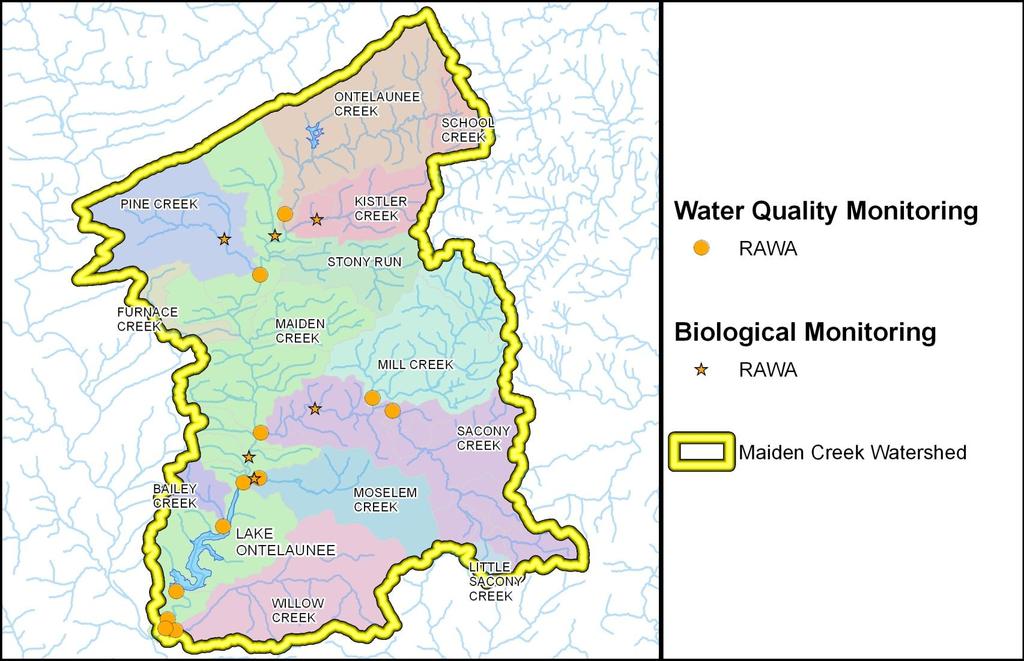
13 WATER QUALITY MONITORING PROGRAM RAWA staff / RAWA onsite lab / MJ Reider lab Data collection from June 2008 present Ten (10) watershed monitoring locations Two (2) intake monitoring locations Chemical parameters monitored weekly or monthly


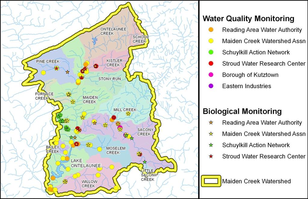
14 MACROINVERTEBRATE MONITORING Schuylkill Action Network (SAN) Five (5) agriculture project sites from to monitor improvements in watershed Additional RAWA sites on impaired streams Partner groups assisting with information
15 MONITORING LOCATIONS
16 MONITORING LOCATIONS
17 WATER QUALITY DATABASE Central database to catalog water quality data Easily extract and analyze data Partner groups sharing information Maiden Watershed Association and Schuylkill Action Network (ongoing) Borough of Kutztown, Eastern Industries
18 WATERSHED WATER QUALITY MONITORING RESULTS Temperature Typically not elevated throughout watershed Seasonal fluctuations and ranges consistent with designated uses of streams
19 Temperature (Degrees C) Temperature Range 30 LEGEND 25 Max Value Upper quartile 20 Median 15 Lower quartile 10 Min Value Mean 5 0 Bailey's Maiden (Rt. 662) Mill Moselem Forge Hill Mouth of Sacony Sample Station N Maiden N of Emer. Intake Willow Brook Trout max temp for survival of short exposure (juveniles) (24 C) Brook Trout max temp for embryo spawning (13 C)
20 WATERSHED WATER QUALITY MONITORING RESULTS Specific Conductivity Highest at Moselem, Sacony and Willow These sites also have higher nitrate levels
21 Conductivity (ms/cm) Specific Conductivity Range 0.7 LEGEND 0.6 Max Value 0.5 Upper quartile 0.4 Median Lower quartile Min Value Mean Bailey's Maiden (Rt. 662) Mill Moselem Forge Hill Mouth of Sacony N Maiden N of Emer. Intake Willow Sample Station
22 WATERSHED WATER QUALITY MONITORING RESULTS Dissolved Oxygen (DO) Lowest DO concentrations: Maiden Rt. 662) Maiden (North of Emergency Intake) Willow Saturated DO acceptable or better at most monitoring locations Saturated DO low in Willow and Maiden (at Route 662) during summer and early fall
23 Concentration (mg/l) Dissolved Oxygen Range 25 LEGEND Max Value 20 Upper quartile 15 Median 10 Lower quartile Min Value 5 Mean 0 Bailey's Maiden (Rt. 662) Mill Moselem Forge Hill Mouth of Sacony N Maiden N of Emer. Intake Willow Sample Station
24 WATERSHED WATER QUALITY MONITORING RESULTS ph Relatively consistent at each site and between sites Low ph (<5) observed in Willow in March 2011 High ph (>10) in Mill attributed to meter malfunction
25 ph (S.U.) ph Range 14 LEGEND 12 Max Value 10 Upper quartile 8 Median 6 Lower quartile 4 2 Min Value Mean 0 Bailey's Maiden (Rt. 662) Mill Moselem Forge Hill Mouth of Sacony N Maiden N of Emer. Intake Willow Sample Station
26 WATERSHED WATER QUALITY MONITORING RESULTS Total Coliform (TC) and E. coli bacteria Presence/absence testing TC and E. coli always present Monitoring discontinued in 2013 May consider bacteria DNA testing in future to determine sources of fecal pollution Nitrate All monitoring < 10 mg/l* Highest in Moselem and Willow * PA DEP drinking water standard = 10 mg/l
27 Concentration (mg/l) Nitrate Range LEGEND Max Value Upper quartile 7 6 Median Lower quartile Min Value Mean 1 0 Bailey's Maiden (Rt. 662) Mill Moselem Forge Hill Mouth of Sacony N Maiden N of Emer. Intake Willow Sample Station
28 WATERSHED WATER QUALITY MONITORING RESULTS Total Suspended Solids (TSS) Concentration spikes associated with large storm events North Maiden Maiden Rt. 662) Bailey s Sacony Northern part of watershed appears to be large source of TSS Sampling location added at mouth of Onteleunee
29 Concentration (mg/l) Max = 107 Max = 265 Max = 212 Max = 100 Total Suspended Solids Range 50 LEGEND Max Value 40 Upper quartile 30 Median 20 Lower quartile Min Value 10 Mean 0 Bailey's Maiden (Rt. 662) Mill Moselem Forge Hill Mouth of Sacony N Maiden N of Emer. Intake Willow Sample Station
30 WATERSHED WATER QUALITY MONITORING RESULTS Phosphorus (P) Monitoring Total Phosphorus and Orthophosphate Low or nondetectable concentrations: North of Maiden Mill Moselem Bailey s Maiden (North of Emergency Intake) Moderate concentrations: Sacony Maiden (@ Rt. 662) Elevated concentrations in Willow Concentration spikes may be related to large storm events Sampling location added in Sacony downstream of Kutztown
31 Concentration (mg/l) Total Phosphate Range LEGEND Max Value Upper quartile Median Lower quartile Min Value Mean Bailey's Maiden (Rt. 662) Mill Moselem Forge Hill Mouth of Sacony N Maiden N of Emer. Intake Willow Sample Station
32 WATERSHED WATER QUALITY MONITORING RESULTS Oxidation-Reduction Potential (ORP) Recently added in 2013 Will be used to characterize manganese cycling in watershed Manganese (Mn) Recently added in 2013 Will be used to characterize manganese cycling in watershed
33 WATER QUALITY by TARGETTED WATERSHEDS Total Suspended Solids North Maiden and its tributaries Bailey s Sacony Willow Phosphorus Sacony Willow Nitrate Moselem Bailey s Willow


34 AGRICULTURAL RESTORATION Schuylkill Action Network Agricultural Workgroup Agriculture Restoration Projects Exotic species removal on restoration sites Contribute funding for development of farm conservation planning and implementation

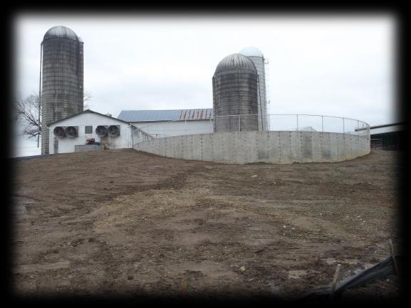

35 AGRICULTURAL RESTORATION Sacony Farm with swine operations
36 Questions? Lori A. Burkert Graduate Geologist SSM Group, Inc N. Park Road Reading, PA
Portland Water District Sebago Lake Watershed Monitoring Programs Crooked River Monitoring (1977 to 2016) Brie Holme
 Brie Holme") Portland Water District Sebago Lake Watershed Monitoring Programs Crooked River Monitoring (1977 to 2016) Brie Holme Introduction Sebago Lake is the primary drinking water supply for 200,000 people in
Portland Water District Sebago Lake Watershed Monitoring Programs Crooked River Monitoring (1977 to 2016) Brie Holme Introduction Sebago Lake is the primary drinking water supply for 200,000 people in
The Status of Pompeston Creek, : From Data to Action. Pompeston Creek Watershed Association
 Pompeston Creek Watershed Association P.O. Box 2883 Cinnaminson, NJ 08077 (856) 235-9204 www.pompestoncreek.org The Status of Pompeston Creek, 1998-2008: From Data to Action Pompeston Creek Watershed Association
Grants Pass Water Quality Monitoring
 Grants Pass Water Quality Monitoring 2003-2005 Rogue Valley Council of Governments April 2005 Rogue Valley Council of Governments Natural Resources Department 155 North First Street Central Point, Oregon
Kinley Creek Monitoring Sites Monitoring Data Summary for March 30 th, 2017 May 3 rd, 2017
 Kinley Creek Monitoring Sites Monitoring Data Summary for March 3 th, 17 May 3 rd, 17 Data Gaps The KINA and KINB stations did not experience any gaps in the data record during this monitoring period.
MassDEP Water Quality Monitoring in the Merrimack Watershed: Therese Beaudoin MassDEP Division of Watershed Management
 MassDEP Water Quality Monitoring in the Merrimack Watershed: 1995-2015 Therese Beaudoin MassDEP Division of Watershed Management Overview Descriptions of the various monitoring programs conducted by MassDEP
Appendix I. Subconsultant Reports. 1-6: Water Quality Laboratory Tests Brandywine Science Center
 Appendix I Subconsultant Reports 1-6: Water Quality Laboratory Tests Brandywine Science Center 7-12: Site Inspection Report Outlines Toth Bros. Clearing and Dredging BRANDYWINE SCIENCE CENTER INC. LAB
Regional Stormwater Management Plan for Troy Brook, Morris County, New Jersey
 Regional Stormwater Management Plan for Troy Brook, Morris County, New Jersey Executive Summary Troy Brook is in the Whippany River watershed, which has the first TMDL in the State of New Jersey, for fecal
Henderson Watershed WRIA 13. Chapter Includes: Tanglewilde Stormwater Outfall Woodard Creek Woodland Creek
 Henderson Watershed WRIA 13 Chapter Includes: Tanglewilde Stormwater Outfall Woodard Creek Woodland Creek 146 Tanglewilde Stormwater Outfall PART OF HENDERSON WATERSHED PRIMARY LAND USES: Urban residential
Section 319 Incremental Project Proposal for Elks Run Watershed West Virginia Stream Code:WVP-1
 1 Section 319 Incremental Project Proposal for Elks Run Watershed West Virginia Stream Code:WVP-1 in the Potomac Direct Drains Watershed Jefferson County, WV 2010 Anticipated need for 319 funding $55,000
SOURCE WATER PROTECTION: Developing a Plan that Works for YOU. Lyn O Hare Spotts, Stevens & McCoy
 SOURCE WATER PROTECTION: Developing a Plan that Works for YOU Lyn O Hare Spotts, Stevens & McCoy SWP What Is Source Water Protection? Taking proactive measures to prevent the pollution of lakes, rivers,
Virginia Department of Environmental Quality Water Quality Monitoring Program
 Virginia Department of Environmental Quality Water Quality Monitoring Program Trend Stations - Historically located, long-term water quality monitoring stations. - Used to assess changes in water quality
Acidity and Alkalinity:
 Evaluation of Pollution Sources to Lake Glenville Quarterly Report December 2018 Kimberlee K Hall, PhD Environmental Health Program, Western Carolina University Summary Chemical and microbial analysis
The Snapshot CONODOGUINET CREEK WATERSHED SNAPSHOT
 CONODOGUINET CREEK WATERSHED SNAPSHOT ABOVE: CONODOGUINET CREEK AT RT 74 BRIDGE FACING DOWNSTREAM The Snapshot The Conodoguinet Watershed Snapshot was a collaborative effort to engage local citizens in
REND LAKE WATER QUALITY
 REND LAKE 1999-2002 WATER QUALITY REPORT U.S. ARMY CORPS OF ENGINEERS, ST. LOUIS DISTRICT ENVIRONMENTAL QUALITY SECTION - Water Quality Billy Arthur, Section Chief Theodore Postol, Environmental Engineer
Lake Wallenpaupack Watershed Assessment Project
 Submitted to: Pennsylvania Growing Greener Grants Center Submitted by: Lake Wallenpaupack Watershed Management District HC 1 Box 15D Paupack, PA 18451 Table of Contents Title Page Executive Summary...
2018 Monitoring Strategy for the Des Plaines River Watershed. Purpose
 2018 Monitoring Strategy for the Des Plaines River Watershed Purpose This Monitoring Strategy for the Des Plaines River Watershed in Lake County Illinois was developed by the Monitoring Committee of the
Dyes Inlet DYES INLET WATERSHED Water Quality Monitoring Report Kitsap Public Health District
 DYES INLET WATERSHED 2014 Water Quality Monitoring Report Kitsap Public Health District 1 2 DYES INLET WATERSHED The Dyes Inlet watershed, designated as Primary Contact waters by the State, is located
2018 WATER QUALITY MONITORING BLUE MARSH RESERVOIR LEESPORT, PENNSYLVANIA
 2018 WATER QUALITY MONITORING BLUE MARSH RESERVOIR LEESPORT, PENNSYLVANIA U.S. Army Corps of Engineers Philadelphia District Environmental Resources Branch January 2019 2018 Water Quality Monitoring Blue
Vancouver Watershed Health Assessment. Burnt Bridge Creek Watershed
 Vancouver Watershed Health Assessment Burnt Bridge Creek Watershed Presentation Overview 1. Introduction 2. Study Context 3. Burnt Bridge Creek Monitoring Program and Trend Analysis 4. Watershed Health
Today s Webinar: Types of Monitoring and Assessment Data and What They Mean
 Welcome to the 1 st Webinar in the Series Monitoring & Assessment for Watershed Plans: Identifying, Accessing, and Using Data to Protect and Restore Indiana s Waters Each Monday in May at noon Today s
Middle Huron Stormwater Plan for Addressing Total Maximum Daily Loads (TMDLs)
") Middle Huron Stormwater Plan for Addressing Total Maximum Daily Loads (TMDLs) The following plan was developed by the Middle Huron Watershed Stormwater Advisory Group (SAG) a collaboration between communities
Middle Huron Stormwater Plan for Addressing Total Maximum Daily Loads (TMDLs) The following plan was developed by the Middle Huron Watershed Stormwater Advisory Group (SAG) a collaboration between communities
CARLYLE LAKE WATER QUALITY REPORT. for
 CARLYLE LAKE WATER QUALITY REPORT for 1997 U.S. ARMY CORPS OF ENGINEERS, ST. LOUIS DISTRICT ENVIRONMENTAL QUALITY SECTION - Water Quality Ted Postol, Section Chief Tori Foerste, Environmental Engineer
MARK TWAIN LAKE 2002 WATER QUALITY
 MARK TWAIN LAKE 2002 WATER QUALITY REPORT U.S. ARMY CORPS OF ENGINEERS, ST. LOUIS DISTRICT ENVIRONMENTAL QUALITY SECTION - Water Quality Ted Postol, Section Chief Tori Foerste, Environmental Engineer Donna
MARK TWAIN LAKE 2002 WATER QUALITY REPORT
 MARK TWAIN LAKE 2002 WATER QUALITY REPORT U.S. ARMY CORPS OF ENGINEERS, ST. LOUIS DISTRICT ENVIRONMENTAL QUALITY SECTION - Water Quality Billy Arthur,Section Chief Ted Postol, Environmental Engineer Rick
VUSP PA Stormwater Symposium Villanova University, PA
 VUSP PA Stormwater Symposium Villanova University, PA 1 Delaware River Watershed 2 Source: ESRI 3 Population 8.5M Source: Kauffman U. Delaware 4 Source: OSI Water supply for 17M Source: DRBC 5 Source:
2014 ASSINIBOINE RIVER MONITORING REPORT
 October 15, 2014 Temperature º C 9.7 9.6 9.6 9.6 9.7 9.7 10.1 10.2 10.1 Dissolved Oxygen mg/l 10.3 10.2 10.2 10.3 10.1 10.2 10.2 10.2 10.2 Conductivity ms/cm 1.262 1.235 1.253 1.307 1.315 1.307 1.322 1.32
Protecting Utah s Water Resources. Nutrient Issues
 Protecting Utah s Water Resources Nutrient Issues Nutrient Issues Questions What are they? Why are they important? Nationally Locally What are the impact on my community Costs Timing What are Nutrients?
MARK TWAIN LAKE WATER QUALITY REPORT. for
 MARK TWAIN LAKE WATER QUALITY REPORT for 1997 U.S. ARMY CORPS OF ENGINEERS, ST. LOUIS DISTRICT ENVIRONMENTAL QUALITY SECTION - Water Quality Ted Postol, Section Chief Tori Foerste, Environmental Engineer
McKenzie Watershed Water Quality Discussion Article
 McKenzie Watershed Water Quality Discussion Article Oregon Department of Environmental Quality Report: Water Years 1996 2004 fostering better stewardship of the McKenzie Watershed resources through voluntary
Goose Management through Habitat Restoration
 Goose Management through Habitat Restoration presented at the Goose Management Workshop Bergen County Community College Paramus, New Jersey March 3, 2009 Christopher C. Obropta, Ph.D., P.E. Extension Specialist
Long Prairie River Watershed Restoration and Protection Strategies (WRAPS) Report Summary
 Report Summary") Long Prairie River Watershed Restoration and Protection Strategies (WRAPS) Report Summary Minnesota has adopted a watershed approach to address the state s 80 major watersheds (denoted by 8-digit hydrologic
Long Prairie River Watershed Restoration and Protection Strategies (WRAPS) Report Summary Minnesota has adopted a watershed approach to address the state s 80 major watersheds (denoted by 8-digit hydrologic
Portland Water District Sebago Lake Watershed Monitoring Programs Crooked River Monitoring (1977 to 2017) Brie Holme
 Brie Holme") Portland Water District Sebago Lake Watershed Monitoring Programs Crooked River Monitoring (1977 to 2017) Brie Holme Introduction Sebago Lake is the primary drinking water supply for 200,000 people in
Portland Water District Sebago Lake Watershed Monitoring Programs Crooked River Monitoring (1977 to 2017) Brie Holme Introduction Sebago Lake is the primary drinking water supply for 200,000 people in
Morro Bay Watershed Creek Health For Water Year 2017
 Morro Bay Watershed Creek Health For Water Year 201 Date Range: October 1, 201 to September 30, 201 Analytes: Dissolved oxygen, water temperature, nitrates as N, orthophosphates as P Background The Morro
Pennsylvania Pequea and Mill Creek Watershed Section 319 National Monitoring Program Project
 Pennsylvania Pequea and Mill Creek Watershed Section 319 National Monitoring Program Project Figure 36: Pequea and Mill Creek (Pennsylvania) Watershed Project Location 231 T-1 C-1 T1-3 T-4 C1-2 T2-3 T-2
2016 WATER QUALITY MONITORING PROMPTON RESERVOIR PROMPTON, PENNSYLVANIA
 2016 WATER QUALITY MONITORING PROMPTON RESERVOIR PROMPTON, PENNSYLVANIA U.S. Army Corps of Engineers Philadelphia District Environmental Resources Branch December 2016 2016 Water Quality Monitoring Prompton
Watershed-Scale Fate and Transport of Bacteria Using SWAT
 Watershed-Scale Fate and Transport of Bacteria Using SWAT Mehran Niazi Dr. Christopher Obropta, P.E. Dr. Robert Miskewitz August 6, 2009 Department of Environmental Sciences, Rutgers University Outline
Jean Unmuth Wisconsin DNR
 Spring Creek Watershed Project Jean Unmuth Wisconsin DNR Cooperators Friends of Scenic Lodi Valley Lodi Public High School Columbia County LWCD UWSP CWS City of Lodi Wisconsin DNR Spring Cr. Watershed
Bacon Creek Watershed Plan Implementation Chapter 3: Learning More - Monitoring to Secure New Data Draft
 Bacon Creek Watershed Plan Implementation Chapter 3: Learning More - Monitoring to Secure New Data Draft There are two main goals of watershed planning: protect good water quality and improve poor water
Smithville Lake 2000 Water Quality Report
 Smithville Lake 2 Water Quality Report 1. General. a. Project location. The dam is located at river mile 12.9 on the Little Platte River, a tributary of the Platte River. The drainage area above the dam
Bee Meadow Pond Shoreline Restoration Project
 Bee Meadow Pond Shoreline Restoration Project Executive Summary Bee Meadow Pond is one of three ponds located in Bee Meadow Park. The ponds are stocked for fishing, but boating and swimming are not allowed.
Portland Water District Sebago Lake Watershed Monitoring Programs Tributary Monitoring ( ) Kirsten Ness
 Kirsten Ness") Introduction Portland Water District Sebago Lake Watershed Monitoring Programs Tributary Monitoring (1977 2016) Kirsten Ness Sebago Lake is the primary drinking water supply for nearly 200,000 people in
Introduction Portland Water District Sebago Lake Watershed Monitoring Programs Tributary Monitoring (1977 2016) Kirsten Ness Sebago Lake is the primary drinking water supply for nearly 200,000 people in
Municipal Stormwater Management Plan Prepared For The Borough of Cape May Point By Van Note-Harvey Associates VNH File No.
 Municipal Stormwater Management Plan Prepared For The Borough of Cape May Point By Van Note-Harvey Associates 2005 VNH File No. 35317-210-21 Table of Contents Introduction... 3 Goals... 3 Storm water Discussion...
2016 WATER QUALITY MONITORING BELTZVILLE RESERVOIR LEHIGHTON, PENNSYLVANIA
 2016 WATER QUALITY MONITORING BELTZVILLE RESERVOIR LEHIGHTON, PENNSYLVANIA U.S. Army Corps of Engineers Philadelphia District Environmental Resources Branch December 2016 2016 Water Quality Monitoring
The Pennsylvania Senior Environment Corps.
 The Pennsylvania Senior Environment Corps www.natureabounds.org Bringing People Together for a Healthy Planet To do so, we educate and empower citizens to sustain their community through environmental
Jordan River Total Maximum Daily Load Study. Presented By: James Harris Utah Division of Water Quality
 Jordan River Total Maximum Daily Load Study Presented By: James Harris Utah Division of Water Quality Jordan River Watershed TMDL Study Area No Introduction Necessary A Few Things to Point Out... Lower
Water Quality Advisory Committee (WQAC) Chloride Trends. Delaware River Basin Commission West Trenton, NJ March 29, 2018
 Chloride Trends. Delaware River Basin Commission West Trenton, NJ March 29, 2018") Water Quality Advisory Committee (WQAC) Chloride Trends Delaware River Basin Commission West Trenton, NJ March 29, 2018 Criteria Exceedances Recent criteria exceedances occurring in Zone 2; Estimated chloride
Water Quality Advisory Committee (WQAC) Chloride Trends Delaware River Basin Commission West Trenton, NJ March 29, 2018 Criteria Exceedances Recent criteria exceedances occurring in Zone 2; Estimated chloride
Water Availability Study Safe Yield Analysis. Lori A. Burkert, P.G
 Water Availability Study Safe Yield Analysis Lori A. Burkert, P.G. lburkert@entecheng.com 610-373-6667 Inflow vs Outflow What is Safe Yield? Maintainable yield of water from a surface or groundwater source
BIG ROCHE A CRI LAKE CHARACTERISTICS
 BIG ROCHE A CRI LAKE CHARACTERISTICS Lake Description Big Roche Cri Lake is located in north central Adams County and has a surface area of 205 acres, a shoreline length of 6.1 mile, a volume of 6,993
Jordan River TMDL Study What Have We Learned So Far?
 Jordan River TMDL Study What Have We Learned So Far? Salt Lake Countywide Watershed Symposium October 29 th, 2008 Hilary Arens & James Harris Utah Division of Water Quality TMDL Update Impairments Water
Impaired Watersheds and Stream Designations in Adams County
 Impaired Watersheds and Stream Designations in Adams County Rod Kime PA Department of Environmental Protection Water Quality Standards What are Water Quality Standards? Protected water uses Ex: Aquatic
2015 Water Quality Monitoring Program Overview
 2015 Water Quality Monitoring Program Overview Scott Gall, Rural Conservationist scott@wmswcd.org Version Date: 2/10/2016 Introduction Since 2009 West Multnomah Soil & Water Conservation District (WMSWCD)
OKLAHOMA CLEAN LAKES AND WATERSHEDS 23rd ANNUAL CONFERENCE AGENDA. SUCCESS STORY: 20 YEARS of HYPOLIMNETIC OXYGENATION of a RESERVOIR
 OKLAHOMA CLEAN LAKES AND WATERSHEDS 23rd ANNUAL CONFERENCE AGENDA SUCCESS STORY: 20 YEARS of HYPOLIMNETIC OXYGENATION of a RESERVOIR Agenda EBMUD & Camanche Reservoir Water Quality Challenges Speece Cone
Kinley Creek Monitoring Sites Monitoring Data Summary for August 19 th, 2017 September 18 th, 2017
 Kinley Creek Monitoring Sites Monitoring Data Summary for August 19 th, 217 September 18 th, 217 Data Gaps The KINA station experienced submergence issues that affected specific conductivity from the date
Redwood Shores Lagoon November 2016 Monthly Water Quality Monitoring Report
 Redwood Shores Lagoon November 2016 Monthly Water Quality Monitoring Report Prepared for Redwood City Public Works Services Department 1400 Broadway Redwood City, CA 94063-2594 Prepared by Clean Lakes,
Tioga County Conservation District Watershed Program
 Tioga County Conservation District Watershed Program What is a watershed? A watershed is the land area that drains into a stream, river, or body of water. In Tioga County, there are seven major watersheds,
Redwood Shores Lagoon February 2019 Monthly Water Quality Monitoring Report
 Redwood Shores Lagoon February 2019 Monthly Water Quality Monitoring Report Prepared for Redwood City Public Works Services Department 1400 Broadway Redwood City, CA 94063-2594 Prepared by Clean Lakes,
Fiscal Year (FY) 2017 CWA 319(h) Grant DRAFT Scope of Work Summary. Upper San Marcos River Watershed Protection Plan Implementation
 2017 CWA 319(h) Grant DRAFT Scope of Work Summary. Upper San Marcos River Watershed Protection Plan Implementation") Fiscal Year (FY) 2017 CWA 319(h) Grant DRAFT Scope of Work Summary Upper San Marcos River Watershed Protection Plan Implementation Submitted by Texas State University, The Meadows Center for Water and
Fiscal Year (FY) 2017 CWA 319(h) Grant DRAFT Scope of Work Summary Upper San Marcos River Watershed Protection Plan Implementation Submitted by Texas State University, The Meadows Center for Water and
Wood Canyon Emergent Wetland Project. City of Aliso Viejo 12 Journey, Suite 100 Aliso Viejo, CA 92656
 Wood Canyon Emergent Wetland Project City of Aliso Viejo 12 Journey, Suite 100 Aliso Viejo, CA 92656 Introduction Wood Canyon is located within Aliso and Wood Canyon Regional Park in southwest Orange County,
The Importance of Riparian Forests
 The Importance of Riparian Forests By Jean Llewellyn Monroe County is the second fastest growing county in Pennsylvania. This rapid growth can be problematic because uncontrolled and unregulated growth
Osher Course. What Lies Beneath the Inland Bays?
 Osher Course What Lies Beneath the Inland Bays? Objectives for Course Describe the Delaware Inland Bays and their tributaries Illustrate the ecology and importance of estuaries Demonstrate the threats
Ploof s Creek South. Johannes Creek. Grand Lake, Ploof s Creek South, Johannes Creek. Introduction
 524 4th Street South Sauk Centre, MN 56378 320.352.2231 Grand Lake, Ploof s Creek South, Johannes Creek Introduction Since the 2012 monitoring season, the Grand Lake Improvement District (Grand LID) and
Redwood Shores Lagoon May 2017 Monthly Water Quality Monitoring Report
 Redwood Shores Lagoon May 2017 Monthly Water Quality Monitoring Report Prepared for Redwood City Public Works Services Department 1400 Broadway Redwood City, CA 94063-2594 Prepared by Clean Lakes, Inc.
LCI Lake Water Quality Summary
 LCI Lake Water Quality Summary General Information Lake Name: Location: Basin: Size: Lake Origins: Major Tributaries: Lake Tributary to?: Water Quality Classification: Shandelee Lake Town of Callicoon,
Red River Gorge Restoration and Watershed Plan Chapter 3: Learning More - Monitoring to Secure New Data Draft
 Red River Gorge Restoration and Watershed Plan Chapter 3: Learning More - Monitoring to Secure New Data Draft There are two main goals of watershed planning: protect good water quality and improve poor
Effect of Turbidity on Dissolved Oxygen in the Lake Macatawa. Watershed
 Effect of Turbidity on Dissolved Oxygen in the Lake Macatawa Watershed Hope College GES 401 Research Project Group Members: Peter Van Heest, Rachel Burkhart, Wyatt Curry Advisor: Dr. G. Peaslee Introduction
Monitoring and Evaluation
 Monitoring and Evaluation The true test of the efficacy of this watershed management plan will be the implementation of the plan goals and objectives. Implementation of watershed plan goals and objectives
Long-Term Volunteer Lake Monitoring in the Upper Woonasquatucket Watershed
 Long-Term Volunteer Lake Monitoring in the Upper Woonasquatucket Watershed Linda Green URI Watershed Watch 1-87-95, lgreen@uri.edu WATER QUALITY IS A REFLECTION OF THE ACTIVITIES IN THE LANDS AND WATERS
Local Drinking Water Protection in the Upper Perkiomen Watershed
 Local Drinking Water Protection in the Upper Perkiomen Watershed SCHUYLKILL WATERSHED CONGRESS POTTSTOWN, PA MARCH 13,2010 Presenters Matt Genchur Source Water Protection Program Manager, Pennsylvania
Delaware River Basin Commission
 Delaware River Basin Commission Special Protection Waters: 2009-2011 Lower Delaware Measurable Change Assessment Delaware Watershed Research Conference 2017 Elaine Panuccio, Water Resource Scientist November
What s Happening in Lake Whatcom?
 What s Happening in Lake Whatcom? Dr. Robin A. Matthews, Director Institute for Watershed Studies Huxley College of the Environment Western Washington University June 6, 2011 Site 2 Basin 2 Lake Whatcom
Thief River One Watershed One Plan Prioritization Matrix Prioritization of Issues
 Thief River One Watershed One Plan Prioritization Matrix Prioritization of Issues The Prioritization Matrix is a categorized table that lists the issues that were compiled for the Thief River watershed,
Delaware River Basin Commission
 Delaware River Basin Commission DRBC Water Quality Monitoring September 12, 2017 John Yagecic, P.E. Manager, Water Quality Assessment Photo by David B. Soete Presentation Topics Key DRBC Monitoring Programs
An Evaluation of Antes Creek. Antes Creek has a drainage area of square miles and is a tributary of the
 An Evaluation of Antes Creek Introduction Antes Creek has a drainage area of 55.75 square miles and is a tributary of the West Branch of the Susquehanna near Jersey Shore, PA. The purpose of this study
PINEY RUN WATERSHED 2005 PROFILE
 PINEY RUN WATERSHED 25 PROFILE Table of Contents Page Watershed Description Water Quality Studies Stream Monitoring Water Chemistry Conditions Water Bacteria Conditions Stream Habitat Conditions Aquatic
DEVELOPING A WATERSHED IMPROVEMENT PLAN TO MEET MULTIPLE COMMUNITY OBJECTIVES IN GAINESVILLE AND HALL COUNTY, GEORGIA
 DEVELOPING A WATERSHED IMPROVEMENT PLAN TO MEET MULTIPLE COMMUNITY OBJECTIVES IN GAINESVILLE AND HALL COUNTY, GEORGIA Chrissy, Thom 1, David Dockery 2, Kevin McInturff 3, Betsy Massie 1, and Lauren Murphy
West Souris River Technical Water Quality Report Summary
 Page 1 West Souris River Technical Water Quality Report Summary SAMPLING BACKGROUND INFORMATION Surface water quality data have been collected by the Water Quality Management Section, Manitoba Water Stewardship,
State of the San Lorenzo River Symposium Saturday, April 11, 2015 Greg Pepping, Executive Director Coastal Watershed Council
 State of the San Lorenzo River Symposium Saturday, April 11, 2015 Greg Pepping, Executive Director Coastal Watershed Council Coastal Watershed Council Santa Cruz-based 501(c)(3) Established 1995 Science-based
Citizen Science Monitoring: Sampling Plan Design and Data Use Monitoring for the DRWI
 Citizen Science Monitoring: Sampling Plan Design and Data Use Monitoring for the DRWI Kathryn Christopher Cluster Outreach and Monitoring Academy of Natural Sciences of Drexel University Delaware River
Environmental Services
 215 Environmental Services River Water Quality Summary for the Twin Cities Metropolitan Area In 215, Metropolitan Council Environmental Services (MCES) river monitoring was conducted at six automated and
Results from the 2017 Water Quality Monitoring Program
 Results from the 217 Water Quality Monitoring Program As part of a larger project, this summer the BWC conducted water sampling throughout the Belleisle Bay to get a baseline of data and determine the
Middle Santa Ana River Bacterial Indicator TMDL 2009 Dry Season Report
 Middle Santa Ana River Bacterial Indicator TMDL 2009 Dry Season Report December 31, 2009 on behalf of Santa Ana Watershed Project Authority San Bernardino County Stormwater Program County of Riverside
Cannon River One Watershed, One Plan. POLICY COMMITTEE MEETING January 10, 2018 Rice County Government Center Faribault, MN
 Cannon River One, One Plan POLICY COMMITTEE MEETING January 10, 2018 Rice County Government Center Faribault, MN TASK Task 1. Aggregate Existing Physical & Spatial Data 1A. Create project maps 1B. Meeting
TMDL Report for Chesapeake Bay Shellfish Waters: Ware Creek, Taskinas Creek, and Skimino Creek Bacterial Impairments (VADEQ, 2010)
") As part of a long term commitment to environmental stewardship, James City County volunteers and staff have been gathering information about stream health throughout the County since 2008. The goal of
As part of a long term commitment to environmental stewardship, James City County volunteers and staff have been gathering information about stream health throughout the County since 2008. The goal of
Delaware River Basin Commission
 Delaware River Basin Commission Managing the Water Quality of a Shared Resource, the Delaware River Kenneth Najjar, Ph.D., P.E. Director, Water Resource Management June 28, 2018 South-East PA - Regional
Riparian Buffers and Stream Restoration
 Riparian Buffers and Stream Restoration Why focus on riparian areas? Link land and water on any given site and link landscapes together in a watershed Riparian corridors protect the circulatory system
El Dorado Hydroelectric Project FERC Project No Water Quality Monitoring Report
 El Dorado Hydroelectric Project FERC Project No. 184 21 Water Quality Monitoring Report EL DORADO IRRIGATION DISTRICT 289 Mosquito Road Placerville, CA 95667 March 211 1. Introduction The El Dorado Irrigation
Grand River Monitoring
 City of Grand Rapids Environmental Services Grand River Monitoring by Mike Lunn Environmental Services Department Manager Grand River Monitoring History 1968 Grand River Monitoring Network Since 1988 Data
Providence Existing Level of Service UNB Regional Stormwater Management District Feasibility Study Phase II
 Memorandum To: From: Upper Narraganset Bay Steering Committee Cynthia Baumann, P.E. Date: Subject: Providence Existing Level of Service UNB Regional Stormwater Management District Feasibility Study Phase
Irrigation. Branch. Crowfoot Creek Watershed Study. Why was this study conducted? How was this study conducted?
 AGRICULTURE, FOOD AND RURAL DEVELOPMENT Irrigation Branch Crowfoot Creek Watershed Study The Crowfoot Creek Study was conducted to determine whether agricultural practices are contributing to the deterioration
Water Resources/Water Quality
 Water Resources/Water Quality From where does your drinking water come? How much land should be set aside for aquifer protection? Why should we care about Barton Springs? What are the effects (if any!)
Sabine River Basin Volunteer Water Quality Monitoring Data Summary Report compiled by Texas Watch
 Sabine River Basin Volunteer Water Quality Monitoring Data Summary Report compiled by Texas Watch This data summary report includes general basin volunteer monitoring activity, general water quality descriptive
Water Resources Agency Annual Board Mtg. FY2012
 Water Resources Agency Annual Board Mtg. FY2012 November 3, 2011 a cooperative program of University of Delaware State of Delaware New Castle County City of Newark City of Wilmington WRA Mission To provide
Countywide Action Plans
 Countywide Action Plans Healthy Waters, Healthy Communities Pennsylvania Phase 3 Watershed Implementation Plan (WIP3) Countywide Action Plans Today s Agenda Overview Countywide Action Plans: Who What When
CLMP+ Report on Grass Lake (Anoka County) Lake ID# CLMP+ Data Summary
 Lake ID# CLMP+ Data Summary") CLMP+ Report on Grass Lake (Anoka County) Lake ID# 02-0113-00 2012-2013 CLMP+ Data Summary October 2014 Authors Shannon Martin, MPCA Editing and graphic design Public Information Office Staff The (MPCA)
CLMP+ Report on Grass Lake (Anoka County) Lake ID# 02-0113-00 2012-2013 CLMP+ Data Summary October 2014 Authors Shannon Martin, MPCA Editing and graphic design Public Information Office Staff The (MPCA)
2016 Monitoring Report; Mississippi River Tributaries
 2016 Monitoring Report; Mississippi River Tributaries SWWD s East Mississippi watershed (Map 1) is named after the former East Mississippi Watershed Management Organization which managed the area prior
Fact Sheet. Pennsylvania s Chesapeake Bay Tributary Strategy Goals for Nutrient and Sediment Reduction and Habitat Restoration
 Fact Sheet Commonwealth of Pennsylvania Department of Environmental Protection Pennsylvania s Chesapeake Bay Tributary Strategy Goals for Nutrient and Sediment Reduction and Habitat Restoration Why were
Water Quality Data Report For Norwalk River Watershed May through September 2015
 Water Quality Data Report For Norwalk River Watershed May through September 2015 Interns collecting data on the Norwalk River at site NR4. Sarah Crosby, Ph.D., Director of Harbor Watch, Earthplace, Westport,
Part 2. SOURCE WATER PROTECTION: Developing a Plan that Works for YOU
 Part 2 SOURCE WATER PROTECTION: Developing a Plan that Works for YOU Mark Stephens, P.G. PA DEP North Central Region Office Williamsport m.stephens@state.pa.us SWP Quick Review What Is Source Water Protection?
Water Quality in the Upper Cohansey Watershed
 Slide 1 Water Quality in the Upper Cohansey Watershed Salvatore Mangiafico County Environmental and Resource Management Agent Cooperative Extension of Salem and Cumberland Counties This talk will present
Habitat Grant Projects Clinton River Watershed
 Habitat Grant Projects Clinton River Watershed L Y N N E S E Y M O U R E N V I R O N M E N T A L E N G I N E E R O F F I C E O F T H E M A C O M B C O U N T Y P U B L I C W O R K S C O M M I S S I O N