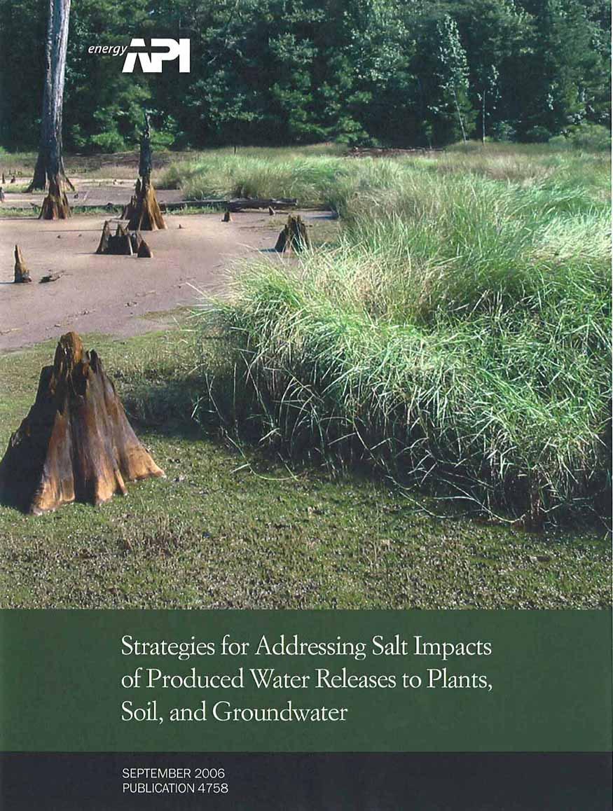
Strategies for Addressing Salt Impacts of Produced Water Releases to Plants, Soil, and Groundwater
|
|
|
- Lorin Sutton
- 6 years ago
- Views:
Transcription
1
 industry uses great care during the handling and disposal of the produced water that is generated as part of oil and gas production.")

2 PUBLICATION 4758 Strategies for Addressing Salt Impacts of Produced Water Releases to Plants, Soil, and Groundwater CHARLES J. NEWELL AND JOHN A. CONNOR GROUNDWATER SERVICES, INC. PURPOSE OF THIS GUIDE The exploration and production (E&P) industry uses great care during the handling and disposal of the produced water that is generated as part of oil and gas production. However, unintentional releases can occur. Depending on the chemical composition of the produced water and the nature of the local environment, salts associated with such releases can impair soils, vegetation, and water resources. This guide provides a collection of simple rules of thumb, decision charts, models, and summary information from more detailed guidance manuals to help you address the following assessment and response issues: 1) Will a produced water release cause an unacceptable impact on soils, plants, and/or groundwater? 2) In the event of such an impact, what response actions are appropriate and effective? HOW TO USE THIS GUIDE Determining when a response action will likely be needed to protect soil, plants, or groundwater. Selecting and implementing an appropriate remedial measure for impacted soils or plants. Evaluating potential impacts on groundwater resources. Background information on produced water and its potential effects. Protecting Soil/Plants: See Rules of Thumb on Page 2 and more detailed decision charts on Pages 4 to 5. Protecting Groundwater: See Rules of Thumb on Page 3 and Planning Model on Pages 9 to 14. Remedy Selection: See decision charts on Pages 4 to 5. Remedy Implementation: See simple guidelines for natural remediation, in-situ chemical amendments, and mechanical remediation on Pages 6, 7, and 8, respectively. Planning Model: See simple procedures for assessing potential effects on groundwater quality on Pages 9 to 14. Beneficial Use Criteria: See general criteria for evaluating the potential use of water resources on Page 15. Produced Water Production and Disposal in the U.S.: Page 16 Definition/ Measurement of Key Parameters: Pages 17 and 21 Potential Impacts on Plants: Page 18 Potential Impacts on Soil: Page 19 Key Factors for Assessing Groundwater Impacts: Page 20 Example Site Assessment: Pages 22 and 23 1
3 SOIL/PLANT IMPACT RULES OF THUMB Evaluating Impacts - SOIL Information from API Publication 4663, Remediation of Salt-Affected Soils at Oil and Gas Production Facilities and other sources was compiled to develop the following Rules of Thumb for response to impacts by produced water. Each Rule of Thumb describes a set of conditions associated with a produced water release and the typical response to such conditions. These Rules of Thumb are for typical rangeland and farmland areas, but may not be applicable to environments with naturally high salinity. For further discussion of conditions not covered by these Rules of Thumb, please go to page 4. IF THESE SOIL CONDITIONS RESULT FROM PRODUCED WATER RELEASE. RULE OF THUMB IS: TECH TIP: See Page 17 for definitions of EC, CEC, TDS, ESP, and SAR. CASE 1 Affected Soil EC > 16 mmhos/cm OR Affected Soil ESP > 22% (SAR > 20) FURTHER STUDY MAY BE NEEDED; GO TO PAGE 4 Source: API Publication 4663 CASE 2 Case 2 Produced Water TDS < 3000 mg/l AND Affected Soil ESP < 12% (SAR < 10) A RELEASE WILL MOST LIKELY NOT SOILS AND/OR PLANTS HARM CASE 3 Case 3 Produced Water TDS < 600 mg/l AND Affected Soil ESP < 12% (SAR < 10) CLEARLY WILL NOT BE A SOIL FERTILITY ISSUE Source: API Publication 4663 CASE 4 Case 4 Affected Soil EC < 4 mmhos/cm AND Affected Soil ESP < 5% (SAR < 5) CLEARLY WILL NOT BE A SOIL FERTILITY ISSUE Source: API Publication 4663 Decision Chart for Soil Impact Rules of Thumb (based on Soil ESP and Soil EC) If meet BOTH, then clearly won t be a soil issue; action most likely not needed. More Detailed Analysis may be needed; see pages 4 and 5. If exceed EITHER, then further study is needed (go to page 4). Soil ESP (%) Soil ESP (%) Soil ESP (%) Soil EC (mmhos/cm) Soil EC (mmhos/cm) Soil EC (mmhos/cm)


4 WHAT SEPTEMBER 2006 GROUNDWATER IMPACT RULES OF THUMB Evaluating Impacts - GROUNDWATER The following Rules of Thumb for response to groundwater impacts by produced water were developed as guidance using information from API Publication 4734, Modeling Study of Produced Water Release Scenarios. In that study, the authors performed several hundred computer simulations with the HYDRUS-1D model to determine the sensitivity of groundwater underlying a produced water release to various factors such as release volume, chloride concentration of the produced water, depth to groundwater, soil type, rainfall and hydrology of the area, and other factors. Each Rule of Thumb describes a set of site conditions associated with a produced water release and assesses the likelihood of an impact to groundwater. These Rules of Thumb may not be applicable to environments with naturally high salinity or areas with multiple releases over several years. For cases not covered by these Rules of Thumb, go to page 9. CASE 1 2 Produced Water Release Volume > 100 bbls AND Produced Water With Chloride Greater Than ~100,000 mg/l AND Depth to Groundwater < 10 ft AND Unsaturated Soil Zone is Sandy HAS POTENTIAL TO IMPACT GROUNDWATER QUALITY. FURTHER STUDY NEEDED - GO TO PAGE 9. CASE 2 2 Entire Produced Water Release Collects in Bermed Area or Topographic Low, Causing Infiltration OR Produced Water With Chloride Greater Than ~100,000 mg/l OR Depth to Groundwater < 10 ft THESE SITE FACTORS MAY INCREASE LIKELIHOOD OF IMPACTING GROUNDWATER - SEE PAGES 9 AND 20 FOR MORE INFORMATION. CASE 3 2 Produced Water With Chloride Less Than ~100,000 mg/l) AND Release Spreads over a Large Area [e.g., Volume release (bbls) Area (sq. ft) < 0.015] AND Depth to Groundwater > 10 ft LESS LIKELY TO IMPACT GROUNDWATER. 3


5 SEPTEMBER 2006 DECISION CHART FOR SOIL / PLANT IMPACTS Evaluating Impacts - SOIL For those sites where produced water impacts to soils requires a corrective action, the following decision chart can be used to select appropriate remedial measures. More detail on specific technologies is provided on pages 7 8. Decision Chart for Salt-Impacted Soils 4 (Adapted from API Publication 4663)
 Evaluating Impacts - SOIL")

6 DECISION CHART FOR SOIL / PLANT IMPACTS (Continued) Evaluating Impacts - SOIL Decision Chart for Salt-Impacted Soils - Continued (Adapted from API Publication 4663) 5
. OPTION A.")

7 NATURAL REMEDIATION OF SOIL IMPACTS Responding to Impacts - SOIL Natural Remediation In-situ Chemical Amendment Mechanical Remediation Concept: Soil Remediation Alternative 1: Natural Remediation Use plants and natural water flushing to restore salt-impacted soils. This option is preferable in cases where remediation equipment can create additional soil damage (such as wetlands). OPTION A. Monitored Natural Revegetation OPTION B. Plant Salt-Tolerant Vegetation Approach: Allow natural revegetation to occur over 1-to 3-year time period and monitor the revegetation process. The affected area should be monitored for barren zones and stressed vegetation over time. If monitoring shows revegetation process is too slow, consider other methods. This method works best with sandy soils and soils containing limited clay. In some cases adding mulch, fertilizer, and water (see Option B, below) can speed up revegetation. Approach: Plant halophytic vegetation that is suitable for the climate and the soil conditions and that can tolerate elevated salinity (see table below for examples of halophytic grasses). Add mulch and fertilizer as necessary: Mulch Rule of Thumb: Till in 2 to 4 inches of mulch over affected area (less for coarse soils, more for fine-grained soils; about five 60-lb bales of hay for every 1000 sq. feet). Fertilizer Rule of Thumb: Add about 28 pounds of fertilizer for every 1000 sq. feet. (For more detail, see API Publication 4663) (Don t add too much fertilizer in a soil; fertilizers can act like salts.) Watering Rule of Thumb: GENERALLY DO NOT ADD WATER BY ITSELF IF SALT IMPACT HAS ALREADY ENTERED SOILS CONTAINING CLAY. IF YOU ARE GOING TO ADD WATER, FIRST ADD CHEMICAL AMENDMENTS (see next page). For more detailed information on mulch / fertilizer addition, see API Publication EXAMPLES OF GRASSES THAT MAY BE USED FOR REVEGETATION Halophyte-assisted natural remediation Photo Courtesy of David Carty GRASS HABIT Min (in/yr) Alkali Sacaton Basin Wildrye Western Wheatgrass Beardless Wildrye Tall Wheatgrass ACCEPTABLE PRECIPITATION RATES Max (in/yr) SOIL TYPE L-M-H U.S. PLANTING SEASON Bunch 8 18 L-M-H Summer Bunch 9 Irrigation OK L-M-H Late Fall/Spring Sod M-H Early Fall/Spring Sod 20 Irrigation M-H Late OK Fall/Spring SEEDING RATE (lbs/ac PLS drilled) SEEDING DRILL DEPTH (inches) 1/ 5 1/ / / 4 Bunch 5 20 L-M-H Spring 8 1/ 2-2 NOTES: This table only presents a few of the grasses that can be used for revegetation. A number of other grasses (such as Bermuda grass) are presented in API Publication 4663 and other literature. SOIL TYPE: L = LIGHT - sands, loamy fine sands, sandy loams M = MEDIUM - silty loams, loams, very fine sandy loams, sandy clay loams H = HEAVY - clay loams, silty clays, clay PLS = Pure Live Seeds. 6
 with calcium and")
 Calculate how much gypsum to add using Calculation Method 1 or Method 2 (below) or use this Rule of Thumb: Add 13 pounds of gypsum per 100 sq.")
8 IN-SITU CHEMICAL AMENDMENT OF SOIL IMPACTS Responding to Impacts - SOIL Natural Remediation In-situ Chemical Amendment Mechanical Remediation Soil Remediation Alternative 2: In-Situ Chemical Amendment Concept: Add a calcium-containing compound, such as gypsum, which serves to replace sodium (which changes the structure and porosity of clays in salt-impacted soils) with calcium and restores the structure of the soil. (See page 19.) Add Gypsum or Other Amendment Approach: 1) Improve drainage, if necessary. 2) Calculate how much gypsum to add using Calculation Method 1 or Method 2 (below) or use this Rule of Thumb: Add 13 pounds of gypsum per 100 sq. feet of impacted soil 3) Add chemical amendments to affected soil. Solid Amendment: Incorporate from surface to depth of 1 to 2 ft using plow. Make sure amendment is in powdered or granular form. Liquid Amendment: Apply over soil surface with or without mechanical incorporation. 4) Adding mulch and fertilizer may enhance rapid restoration (see page 6). 5) Use perimeter berms to contain rainfall or use sprinkler irrigation in affected area to increase infiltration and leach salts (sodium) from affected soils. Rules of Thumb: ADD CHEMICAL AMENDMENTS BEFORE IRRIGATION OR A PERIOD OF HEAVY RAIN. Pulse flooding (watering with a few inches of water every few days) can reduce water requirements by half. A final top dressing of gypsum or mulch can protect the soil surface from dispersing after a rainfall or water event. See page 5 for amount of supplemental irrigation that is needed. Install erosion controls, if necessary. Addition of Chemical Amendment Photo Courtesy of David Carty TECH TIP 1: If soil ph is between 5.5 and 8.5, and if chloride or nitrate will not impact groundwater, you can replace gypsum with: Calcium Chloride [CaCl 2 :2H 2 0] at 0.85 pounds per pound gypsum requirement Calcium Nitrate [Ca(NO 3 ) 2 ] at 0.95 pounds per pound gypsum requirement TECH TIP 2: Adding more than the calculated amount of calcium will not hurt the soil. Calculation Method Method 1: 1: Amount Amount of of Gypsum Needed Based Based on on Soil Soil ESP, ESP CEC and CEC Formula: Calculation Method 2: 2: Amount of of Gypsum Based Needed Based on on Strength Sodium of Concentration Produced Water in Produced Release Water Release Formula: No. of lbs of gypsum to add per square foot of impacted soil (in pounds / ft 2 ) = [ESP - 5] x [CEC] x [ ] No. of lbs of [sodium concentration] x [6.94] gypsum to add = x [volume spilled] x [ ] (in %) (in meq/100 grams) to affected (sodium concentration in mg/l) area (volume spilled in bbl; 42 gallons per bbl) (in pounds) Calculation Steps: 1. Perform calculation for 0 to 1 ft layer. 2. Perform calculation again for 1 to 2 ft layer. 3. Add lbs per sq. ft. numbers together. 4. Multiply lbs of gypsum per sq. ft. by area of spill in sq. ft. to get lbs of gypsum. 5. If soil ph is <5.5, then may need to add CaCO 3 to replace some of the gypsum. See API Publication If soil ph > 8.5, then may need to add sulfur or alternative chemical to decrease ph. See API Publication Calculation Steps: 1. Calculate lbs of gypsum to add using formula shown above. 2. Note that sodium typically comprises 20-35% of the TDS concentration, and can be estimated as (0.2 to 0.35) x TDS (mg/l). 7

9 MECHANICAL REMEDIATION OF SOIL IMPACTS Responding to Impacts - SOIL Natural Remediation In-situ Chemical Amendment Remediation Mechanical Remediation Soil Remediation Alternative 3: Mechanical Remediation Concept: Mechanical Remediation refers to a number of remediation techniques that involve mechanical mixing, spreading, or relocation of the affected soil. OPTION A. Land Spreading Approach: Spread salt-affected soil over a large area and mix with unaffected soils to reduce the salt concentration to an acceptable level. Use front-end loader or backhoe for small spills; use dozers, trackhoes for larger spills. Use the following method to calculate the required area and thickness for land spreading: Formula 1: Area required for spreading = (in square feet) [Volume of salt-affected soil to be spread] x [(spill soil EC) (receiving soil EC)] x 2.6* [(final soil EC goal) (receiving soil EC)] (Volume in cubic feet. EC in mmhos/cm) Formula 2: Thickness of salt-affected soil [Volume of salt-affected soil] to be spread on received soil = [Area required for spreading] (in feet) (Volume in cubic feet. Area in square feet) * This equation assumes 1.3 times expansion factor and a 0.5 foot mixing thickness. OPTION B. Burial Approach: Construct burial vault that may have one or more of the following features (Source: API Publication 4663): Topsoil Clean soil with clay Layer of gypsum Layer of sand Place capillary barrier of plastic, gravel, or rock above salt-affected soil 5 ft 6 ft Mound topsoil and vegetation If possible, top of salt-affected soil should be at least 6 feet below surface soil. If possible, bottom of saltaffected soil should be at least 5 feet above seasonal high water table. OPTION C. Road Spreading Approach: Check with regulatory agencies to determine how road spreading may be performed. If acceptable, apply salt-affected soils so that salt does not damage the road bed, roadside vegetation, or significantly affect runoff water (same as with land spreading). OPTION D. Soil Washing Approach: Use soil washing contractor to mix water with salt-affected soil to decrease salinity. Collect rinse water for treatment or disposal. Note this option is likely to be more costly than other options. OPTION E. Off-Site Disposal Approach: Excavate and transport salt-affected soil to approved landfill as an exploration and production waste. Transport manifests may be required by some regulatory agencies. Fill excavation with clean fill and plant appropriate vegetation. 8

10 PRODUCED WATER AND GROUNDWATER Evaluating Impacts - GROUNDWATER Chloride Transport Pathway Chloride associated with a produced water release to the surface can impact surface soils and be transported to underlying groundwater. The transport process can be separated into four separate steps as shown below. This guide provides a Planning Model (see below and pages 10-14), that can be used to evaluate this migration process. Information on Beneficial Uses of groundwater is provided on page 15. A summary of key parameters that influence chloride transport to groundwater are shown on page 21. Step 1. Salt is released on surface. Step 2. Salt is carried through unsaturated zone via recharge (infiltration) by rainwater (precipitation). Step 3. Recharge water containing salt mixes with clean groundwater flowing beneath the release area to form groundwater plume. Step 4. As the groundwater plume migrates away from the original release area, the plume gets weaker due to mixing. Step 5. Pumping well (if present) can extract groundwater containing diluted salt. Using the Planning Model Results of this modeling are combined with other site-specific information to determine the potential effects on groundwater. To use the Planning Model, perform the following steps: Step 1: Estimate Mass of Chloride using volume and chloride concentration of a produced water release, OR Estimate Mass of Chloride using the area of produced water release (area of affected soil) and the chloride concentration of the soil (page 10) Step 2: Estimate Chloride Loading Rate to Groundwater using the Annual Precipitation, (page 11) Step 3A: Estimate Increase in Chloride Concentration in Groundwater at the Release Point using the width of the release area, (page 12) Step 3B: Refine the estimate from Step 3A using site-specific information (either the site location, or more detailed hydrogeologic info), (page 13) Step 4: (Optional) Estimate the Increase in Chloride Concentration in Groundwater at a Downgradient Point using the distance from the release area (and other parameters), (page 14) Key assumptions and limitations of the Planning Model include: 1) salts are mixed evenly throughout the soil; 2) the percentage of the rainfall that infiltrates through the soil to groundwater is proportional to the amount of rainfall; 3) the recharge rate is the 80 th percentile of recharge rates from data compiled from API Publication 4643; 4) almost all the salts in affected soils can be flushed out with 12 inches of recharge (from API 4663); 5) no capillary effects, evaporation, or other transport processes except advection, mixing, and dispersion in the saturated zone are present; 6) no density effects are assumed in transport of chloride in groundwater; 7) salt is mixed throughout the water-bearing unit; 8) a 2x safety factor is assumed; and 9) potential impacts only apply to the uppermost water-bearing unit, and NOT to deeper, regional aquifers. When applied to site conditions presented in API Publication 4734, the Planning Model was more likely to show higher chloride concentrations in groundwater than chloride concentrations predicted by HYDRUS, a much more sophisticated leaching model. Other Methods Other approaches can also be used to provide more accurate estimates of chloride migration. Key resources include: API Publication 4734: In this study, the authors performed several hundred computer simulations with the HYDRUS model to determine the sensitivity of groundwater underlying a produced water release to various factors such as release volume, chloride concentration of the produced water, depth to groundwater, soil type, rainfall and hydrology of the area, and other factors. Review of this document can provide additional information regarding the impact of produced water releases on groundwater. More Detailed Computer Models: Models such as VADSAT or HYDRUS can be applied to investigate potential groundwater impacts from produced water releases. Site Investigation: A groundwater site investigation involving the collection of groundwater samples from monitoring wells or direct push sampling techniques can show if a produced water release has actually affected groundwater at a given site. Factors That May Influence Remediation of Saltwater Releases For the purposes of this guide, the principal objective of groundwater remediation is to maintain the beneficial use of the groundwater resource. However, remediation of saltwater releases can be influenced by a variety of non-technical factors that are not directly addressed in this guide. These non-technical factors include (API Publication 4663): Landowner claims Lease agreements Federal, state, and local regulations Reduction of long-term liabilities Company policies 9
11 GROUNDWATER EFFECTS: PLANNING MODEL STEP 1 Evaluating Impacts - GROUNDWATER STEP 1: Estimate MASS OF CHLORIDE RELEASED by either Method A or Method B below: METHOD A. You know Volume of Affected Soil and its Chloride Concentration OR METHOD B. You know Volume of Produced Water Release and its Concentration USE THIS GRAPH USE THIS GRAPH Mass of Chlorides in Soil (pounds) ) 10,000,000 1,000, ,000 10,000 1, Chloride Conc. = 100,000 mg/kg Chloride Conc. = 50,000 mg/kg Chloride Conc. = 10,000 mg/kg Chloride Conc. = 5,000 mg/kg Chloride Conc. = 1,000 mg/kg Chloride Conc. = 500 mg/kg Chloride Conc. = 100 mg/kg ,000 10, ,000 Volume of Affected Soil (cubic feet) Mass of Chloride in Release (pounds) ) 10,000,000 1,000, ,000 10,000 1, Chloride Conc. = 100,000 mg/l Chloride Conc. = 50,000 mg/l Chloride Conc. = 10,000 mg/l Chloride Conc. = 5,000 mg/l Chloride Conc. = 1,000 mg/l Chloride Conc. = 500 mg/l Chloride Conc. = 100 mg/l ,000 10, ,000 Volume of Produced Water Release (bbl) OR USE THIS EQUATION OR USE THIS EQUATION Mass = Area of x Depth of X Chloride Conc. (9500) Chloride Affected Soil Affected Soil of Affected Soil (in lbs (in sq feet) (in feet) (in mg/kg) chloride) Mass Chloride = (Volume Released) x (Chloride Concentration) (2900) (in lbs chloride) (in barrels) (in mg/l or ppm) GO TO STEP 2 WITH MASS OF CHLORIDE METHOD A EXAMPLE METHOD B EXAMPLE Example: Mass of chloride in 50 ft x 10 ft area of affected soil with 5000 ppm chloride in soil to 2 feet deep. Example: Mass of chloride from 1000 bbl release with 500 mg/l chloride: Mass Chloride = (50 ft) x (10 ft) x (2 ft) x (5000 ppm) (9500) (lbs chloride) Mass Chloride = 526 pounds Mass Chloride = (1000 bbl) x (500 mg/l) (2900) (lbs chloride) Mass Chloride = 172 pounds BACKGROUND These graphs and equations are based on conventional mass calculations for affected water and soil. See page 9 for more information about the assumptions and limitations related to the Planning Model. NOTE: 1 bbl = 42 gallons = 159 liters. 10
12 GROUNDWATER EFFECTS: PLANNING MODEL STEP 2 Evaluating Impacts - GROUNDWATER STEP 2: Estimate the CHLORIDE LOADING RATE TO GROUNDWATER (in grams per day): Start with CHLORIDE MASS USE THIS GRAPH THEN ADJUST THE ANSWER FOR SOIL TYPE Chloride Loading Rate to Groundwater (grams/day) 10,000,000 1,000, ,000 10,000 1, Rainfall=55 inches/year Rainfall=45 inches/year Rainfall=35 inches/year Rainfall=25 inches/year Rainfall=15 inches/year Rainfall= 5 inches/year ,000 10, ,000 1,000,000 Chloride Mass (pounds) If SANDY SOIL: Use chloride loading rate shown in the graph or equation. If SILTY SOIL: Divide the chloride loading rate from graph or equation by 2 (i.e., 2). If CLAYEY SOIL: Divide the chloride loading rate from graph or equation by 10 (i.e., 10). OR USE THIS EQUATION Chloride Loading Rate to GW = (Mass Chloride) x (Annual Rainfall) (in grams/day) (in lbs) (in in/yr) (Note: Using the square of the rainfall is correct; the higher the annual rainfall, the higher the fraction of rainfall that reaches groundwater. GW = groundwater) GO TO STEP 3A WITH CHLORIDE LOADING RATE BACKGROUND: This graph and this equation are based on: 1) An empirical equation to estimate the recharge rate to groundwater due to rainfall developed by Connor et al., 1997, for the Texas Commission on Environmental Quality. The recharge equation was derived from a study of numerous recharge studies in API Publication 4643, and represents a conservative estimate for recharge (i.e., overpredicts). 2) It is assumed that the excess salinity in an affected soil can be fully flushed from soil by 12 inches of recharge (API Publication 4643). 3) A safety factor has been applied (i.e., the chloride loading rate is increased by a factor of 2 to ensure that the planning model generally overpredicts results compared to the HYDRUS model). 4) See Page 9 for more information about the assumptions and limitations associated with the Planning Model. EXAMPLE Example: Take results from Example B on page 10. Assume SILTY SOIL and 40 inches per year of rainfall. Chloride Loading Rate to GW = (172 lbs) x (40 in/yr) 2 (1000) (2) (in grams/day) Chloride Loading Rate to GW = 138 grams per day (about 0.3 pounds per day) 11
13 GROUNDWATER EFFECTS: PLANNING MODEL STEP 3A Evaluating Impacts - GROUNDWATER Step 3A: Estimate the increase in concentration of chloride in groundwater next to the release (at a generic site) by dividing the chloride loading rate by an estimate of the groundwater flow that mixes with the chloride: Start with CHLORIDE LOADING RATE DETERMINE THE WIDTH OF THE RELEASE AREA Effective Width of Release Area Perpendicular to Groundwater Flow Groundwater Flow Direction Plume (if present) Produced water release area USE THIS GRAPH OR USE THIS EQUATION Increase in Chloride Concentration in Groundwater Adjacent to Release (mg/l) 10,000 1, Eff. Release Width =10 ft Eff. Release Width =50 ft Eff. Release Width =100 ft Eff. Release Width =500 ft Eff. Release Width =1000 ft Increase in Chloride Conc. = { (Chloride Loading Rate) (Eff. Width) } x (13) at a Generic Site (in mg/l) (in g/day) (in ft) Note: This assumes a national average groundwater Darcy velocity from a statistical study of 400 hazardous waste sites (from API Publication 4476). For more information regarding uncertainty and differences in discharge rate between regions, see page 13. GO TO STEP 3B WITH INCREASE IN CHLORIDE CONCENTRATION ,000 10, ,000 1,000,000 Chloride Loading Rate to Groundwater (grams/day) BACKGROUND To estimate the increase in chloride concentration in groundwater, the chloride loading rate is divided by an estimate of the groundwater flow that mixes with the chloride. The groundwater flow is assumed to be the groundwater Darcy velocity (hydraulic conductivity times hydraulic gradient) multiplied by the estimated mixing zone thickness for the water-bearing unit underlying the release area. For this method, a typical value for groundwater discharge of 1000 cubic feet per year per foot of water-bearing unit width was derived from: i) a statistical study of 400 hazardous waste sites prepared by API (API Report No. 4476) when a mid-range Darcy groundwater velocity of 33 ft/yr was indicated; and ii) an estimated value for the mixing zone thickness of 30 feet. EXAMPLE Assume a chloride loading rate of 138 grams per day and a release area effective width of 100 ft: Increase in Chloride Conc. (mg/l) = [(138 grams/day) (100 ft)] x (13) at a Generic Site Increase in Chloride Concentration (mg/l) = 18 mg/l See Page 9 for more information about the assumptions and limitations of the Planning Model. 12

14 GROUNDWATER EFFECTS: PLANNING MODEL STEP 3B Evaluating Impacts - GROUNDWATER STEP 3B: Adjust the increase of concentration in chloride to account for more site-specific groundwater conditions: METHOD A, Regional Estimate: You want to account for regional differences in groundwater velocity METHOD B, Site-Specific Estimate: You know groundwater velocity and water-bearing unit thickness GO TO NEXT STEP (STEP 4) USE THIS CHART TO GET GROUNDWATER (GW) FLOWRATE USE THIS EQUATION Adjusted Increase in = (Increase in (Groundwater (WBU Thickness) x (1000) Chloride Conc. Chloride Conc. from Velocity) (WBU: water-bearing (mg/l) Step 3A) (mg/l) (Darcy Velocity, ft/yr) unit, ft) GW Flow Rate (ft 3 / yr / ft width) Median Value 25 th Percentile 75 th Percentile Western Mountain Ranges Alluvial Basins Colorado Plateau and Wyoming Basin High Plains Non-Glaciated Central Atlantic and Gulf Coastal Plain All Other Regions THEN USE GW FLOWRATE IN THIS EQUATION Adjusted Increase in Chloride Concentration (mg/l) = Increase in Chloride Concentration (mg/l) from Step 3A Value from Chart x 1000 BACKGROUND The groundwater dilution capacity estimate can be improved by utilizing groundwater velocity and water-bearing unit thickness several ways: METHOD A: Use regional values derived from the HGDB Hydrogeologic Database (Newell et al., 1990), a statistical study of 400 hazardous waste sites prepared by API (API Report No. 4476). Median values and upper-range (75 th percentile) and lower-range (25 th percentile) values are presented. This method assumes a 30-ft mixing zone thickness and the effective source width entered during STEP 3A (see the previous page). METHOD B: Use site-specific data from near-by water supply or monitoring wells. EXAMPLE Option A. Assume site is in Atlantic and Gulf Coastal Plain. Adjusted Increase in Chloride Conc. = (Increase in Chloride Conc. from Step 3A Value from Chart) x 1000 Adjusted Increase in Chloride Conc. = (18 mg/l 200) x 1000 Adjusted Increase in Chloride Conc. = 90 mg/l NOTE: This is likely to over-estimate the increase in chloride concentration. See Page 9. See Page 9 for more information about the assumptions and limitations of the Planning Model. 13
15 GROUNDWATER EFFECTS: PLANNING MODEL STEP 4 Evaluating Impacts - GROUNDWATER STEP 4 (Optional): Estimate the change in concentration in groundwater after it has mixed with groundwater at a point downgradient of the release area: Chloride concentration from Step 3 Distance from Source to Downgradient Point (L R )(ft) Produced Water Release Area Chloride concentration from Step 4 METHOD A. You only know distance to downgradient point OR OTHER METHODS. USE THIS GRAPH RF DAF (-) (-) Distance from Source to Downgradient Point (ft) Eff. Source Width =500 ft Eff. Source Width =250 ft Eff. Source Width =100 ft Eff. Source Width =50 ft Eff. Source Width =10 ft Several methods are available to account for the effect of the mixing (dispersion and other processes) of chloride plumes as they migrate downgradient: Graphical Methods: API Publication 4659 Graphical Approach for Determining Site-Specific Dilution-Attenuation Factors (DAFs) uses the Domenico analytical solution to develop graphical approach for estimating Dilution Attenuation Factors (DAFs). Note that DAF = 1 RF where RF is the Reduction Factor. Groundwater Models: Groundwater model such as BIOSCREEN, MT3D, etc., can be used to model the dispersion caused by the movement of the chloride plume to a downgradient location. To use these models, the hydrogeologic characteristics of the water-bearing unit (hydraulic conductivity, gradient, effective porosity) and key transport parameters (dispersivity, source characteristics) must be measured or estimated. Site Investigation: A groundwater site investigation involving the collection of groundwater samples from monitoring wells or direct push sampling techniques can show if a produced water release has actually affected groundwater at a given site. RF = Reduction Factor FINAL ANSWER Increase in Chloride Concentration at Downgradient Point = [Increase in Chloride Concentration from Step 3] x [RF] BACKGROUND METHOD A: The steady-state Domenico analytical transport model was used to develop a family of computer simulations. Two-dimensional aquifer conditions were assumed. Longitudinal dispersivity was assumed to be equal to 10% of the modeled distance. Transverse dispersion was assumed to be 10% of longitudinal dispersion. EXAMPLE To predict the groundwater concentration at a point 1000 ft downgradient of a release area that is 100 ft wide and has increased the chloride concentration by 90 mg/l: Increase in Chloride Concentration (mg/l) = 90 mg/l x RF RF 1000 ft downgradient from Method A Chart = 0.28 Increase in Chloride Concentration (mg/l) = 90 mg/l x 0.28 (from METHOD A chart) 1000 ft downgradient = 25 mg/l 14
.")
16 EVALUATING GROUNDWATER IMPACTS Responding to Impacts - GROUNDWATER Beneficial Uses of Groundwater If an increase in the chloride concentration in groundwater is known or estimated (i.e., by using the Planning Model, more sophisticated model, or sampling wells), the impact on the beneficial use of the groundwater can be determined. Beneficial uses MAY include: drinking water supply; industrial water supply; irrigation or livestock water; and discharge to surface water (aquatic life). KEY POINT: There is no impairment to the resource unless the actual beneficial use of the water is restricted or impaired. The applicability of a given groundwater resource for these beneficial uses may depend, in part, on the concentrations of saltrelated constituents, such as chloride and/or total dissolved solids (TDS). In the United States, groundwater is often regulated by the state governments on the basis of the use of the groundwater. Examples of beneficial uses are shown below: Drinking Water and Industrial Uses The Safe Drinking Water Act sets standards for drinking water quality to be achieved for public water supplies. Total dissolved solids and chloride are not considered by the U.S. EPA to present a risk to human health at the Secondary Maximum Concentration Level (SMCL) but are considered nuisance chemicals and have the following SMCLs: Secondary MCL * Noticeable Effects Constituent (mg/l) Above Secondary MCL Total Dissolved 500 hardness; deposits; colored water; Solids (TDS) staining; salty taste Chloride 250 salty taste Industrial water quality requirements vary significantly, depending on the particular industry. For most industries, the acceptable concentrations of chloride and TDS are significantly higher than drinking water standards in most cases. * The U.S. EPA does not consider these constituents to present a risk to human heath at these levels. These levels are established only as guidelines to assist public water systems in managing their drinking water for aesthetic considerations, such as taste, odor, and color. Aquatic Life Protection The U.S. EPA (1988; 2006) developed ambient aquatic life criteria for chloride for acute exposures (860 mg/l) and chronic exposure (230 mg/l). Several states developed aquatic life criteria for non-priority pollutants including TDS that range from 250 mg/l to 2500 mg/l (Iowa, 2003). Agricultural Uses of Water There is a wide variety of research that summarizes the effect of salinity on livestock and irrigation. Data compiled by USDA- NCRS and presented in API Publication 4663 is summarized below: Groundwater Response Actions If groundwater is impacted adversely, there are a wide variety of approaches that can be taken to manage the problem, including installation of an engineered solution, providing an alternative water supply, implementing a passive remediation approach, evaluating the actual risk associated with the impact and/or combining approaches. Example technologies include: Natural Attenuation; Alternative Water Supply; Plume or Source Containment; Point of Use Treatment; and Groundwater Pump and Treat. 15


17 PRODUCED WATER OVERVIEW Background - PRODUCED WATER Produced Water Produced water refers to water from underground geologic formations that is brought to the surface (or produced ) in the process of oil or natural gas production. This formation water has been in contact with the geologic strata for many thousands of years and, as a result, may contain elevated concentrations of natural minerals that have dissolved from the rock or soil. The resulting chemical composition of the produced water can vary from fresh to very saline, as follows (USGS): Brine (total dissolved solids (TDS) greater than 35,000 mg/l (ppm)) Highly saline (TDS between 10,000 and 35,000 mg/l) Moderately saline (TDS between 3,000 and 10,000 mg/l) Slightly saline (TDS between 1,000 and 3,000 mg/l) Freshwater (TDS less than 1,000 mg/l) The E&P industry uses great care during the handling and disposal of produced water. However, unintentional releases do occur. How Does Produced Water Quality Vary Across The U.S.? This map from the U.S. Geological Survey (Breit and Otton, 2002) based on almost 60,000 produced water analyses taken across the country, shows the Total Dissolved Solids (TDS) content to vary significantly among the various oil and gas regions of the U.S. Such variations are explained by the age, geochemistry, and hydrology of the specific formation(s) from which the water comes. In the Powder River Basin of Wyoming, gas production zones can yield produced water with a TDS < 1000 mg/l, corresponding to freshwater, while in some areas of Oklahoma and West Texas, the TDS content can exceed 200,000 mg/l, corresponding to strong brine. Total Dissolved Solids (TDS) (mg/l) Key Produced Water Statistics HOW MUCH PRODUCED WATER IS GENERATED IN THE U.S.? 18 billion barrels of water in 1996, down from 21 billion barrels in 1985 (API, 2000). For comparison, U.S. oil production in 1996: 2.4 billion barrels of oil. HOW IS IT MANAGED? In the United States in 1995, produced waters were managed in accordance to state regulations (API, 2000). 92% Injected (three-fourths for enhanced oil recovery, one fourth in Class II injection wells) 3% Discharged to surface water (mostly low salinity water from coalbed methane production) 3% Disposed (in percolation pits, on-site evaporation, and treatment plants) 2% For Beneficial Use TECH TIP: Concentrations of salts in groundwater are usually reported in milligrams per liter ( mg/l ). For water samples, this is approximately the same as a part per million (ppm). The difference between mg/l and ppm increases as the salt concentration of the water sample increases. 16
 dissolved in the water.")
. For Soil: Use the Paste Extract Method 62-2.2 (Black, 1965).")
 filtering the water to remove suspended solids, 2) heating the sample to drive off all the water, and 3) weighing the residue.")
18 DEFINITION OF KEY PARAMETERS Background - DEFINITIONS EC: Electrical Conductivity Description: EC represents the ability of a solution to carry an electrical current through ions in the water. In practice, EC is proportional to the amount of inorganic ions (primarily sodium, chloride, sulfate, calcium, potassium, magnesium, and bicarbonate) dissolved in the water. EC is the opposite of resistivity and may also be called specific conductance. Units: EC is measured in milli-mhos per centimeter (mmhos/cm), or decisiemens per meter (ds/m). Note that 1 mmhos/cm = 1 ds/m. Method: For Liquid: Use Method (Black, 1965). For Soil: Use the Paste Extract Method (Black, 1965). TDS: Total Dissolved Solids Description: TDS is the total sum of all dissolved constituents in the water. This test is performed by: 1) filtering the water to remove suspended solids, 2) heating the sample to drive off all the water, and 3) weighing the residue. Units: TDS is reported in milligrams per liter (mg/l). For most applications, mg/l can be assumed to be equivalent to parts-per-million (ppm). Method: (U.S. EPA, 1983) or estimated from liquid EC. Few ions available to carry electrical charge through water or soil paste Low EC Many ions available to carry electrical charge through water or soil paste High EC DATA TIP 1: Some meters and laboratories report specific conductance in units of micro-mhos per centimeter (µmhos/cm), particularly for water samples. Make sure to convert micro-uhos/cm (µmhos/cm) to millimhos per centimeter (mmhos/cm) by dividing micro-mhos/cm by 1000 to use some of the rules in this guide! DATA TIP 2: EC and TDS are two different measurements for the same water quality characteristic. EC is an indirect measurement that can be performed in the field with a meter, while TDS is a direct measurement performed in the lab. You can convert between them with: IF EC < 5 mmhos/cm: EC (mmhos/cm) x 613 = TDS (mg/l or ppm) IF EC > 5 mmhos/cm: EC (mmhos/cm) x 800 = TDS (mg/l or ppm) CEC: CATION EXCHANGE CAPACITY OF SOIL Description: A cation is a positively charged ion. For evaluation of soil sodicity, the key cations are calcium, potassium, magnesium, and sodium. CEC is the total amount of exchangeable cations that can be held in the soil (i.e., cations that can be removed and exchanged for other cations in waters infiltrating through the soil). Units: Milliequivalents per 100 grams soil. Method: 57-3 (Black, 1965) ESP: EXCHANGEABLE SODIUM PERCENTAGE OF SOIL Description: The percentage of CEC of a soil sample that is comprised of sodium. Similar to SAR (sodium adsorption ratio). Units: Percent (%) Exchangeable Sodium (meq/100 grams soil) Calculation: ESP = x 100 CEC (meq/100 grams soil) SAR: SODIUM ADSORPTION RATIO OF SOIL Description: An indication of the sodium hazard to a soil. Similar to ESP. Units: unitless (-) [ Sodium( meq / l )] Calculation: SAR = [ Calcium( meq / l ) + Magnesium( meq / l )] 2 (in concentrations of meq/l), or use DATA TIP 3. Importance of CEC, ESP, and SAR Clays and organic soils have a large number of negatively-charged sites that can hold cations such as sodium. During a salt spill, the calcium, potassium, and magnesium can be replaced by sodium, which changes the structure of the clays. DATA TIP 3: ESP and SAR are two expressions for the fraction of the soil s cations that are comprised of sodium. You can convert between ESP and SAR using the following approximation: x SAR ESP(in %) = 100 x 1+ ( x SAR) DATA TIP 4: The chloride concentration and sodium concentration of produced water can be estimated by assuming all of the TDS is comprised of salt, and using the following equations: Sodium concentration (mg/l) Chloride Concentration (mg/l) = TDS (mg/l) x 0.2 (low end estimate) = TDS (mg/l) x 0.35 (high end estimate) = TDS (mg/l) x 0.3 (low end estimate) = TDS (mg/l) x 0.6 (high end estimate) 17
 the gravitational field. Plants work against the capillary tension of water within the soil pores in order to draw in water.")

19 SALT IMPACT ON PLANTS Background - PLANTS How Salt Can Affect Plants Water present within the soil pores is subject to several forces related to: i) the soil solid phase; ii) the dissolved salts; and iii) the gravitational field. Plants work against the capillary tension of water within the soil pores in order to draw in water. An increase in the TDS of the soil pore water increases the osmotic effect, thereby increasing the force a plant must exert to extract water from the soil. This can cause plants to go into drought stress even though a substantial amount of water may still be present in the soil. Plants are more sensitive to salinity during germination than in later stages of growth. Sprigging, sodding, or transplanting of plant materials is a way to avoid the sensitivity of the seedling stage. Symptoms of Plant Stress Caused by Salt Excessive soil salinity can result in barren spots, stunted vegetative growth with considerable variety in size, and a deep blue-green foliage (USDA, 1954). Plants that are stunted due to low fertility are usually yellow-green, while those stunted due to elevated salinity are characteristically blue green. The bluish appearance is the result of an unusually heavy waxy coating on the surface of the leaves, and the darker color is due to increased chlorophyll content. Some plants may develop dead areas or tipburn or exhibit cupping or rolling of the leaves. Soil Salinity Levels at Which 50% Decrease in Plant Yield is Expected. Data Compiled by Ayers and Westcot (1977). Soil Salinity (mmhos/cm) Effects of Salt-Impacted Soil on Plant Growth Use with permission of Tolerance of Specific Plant to Sodicity (excess sodium) of Soil (adapted from Keech, 1995) Soil Salinity (mmhos/cm) SENSITIVE MODERATELY TOLERANT VERY TOLERANT TOLERANT SOIL ESP ESP = 2-20 = 2-20% SOIL ESP ESP = = 20-40% SOIL ESP ESP = = 40-60% SOIL ESP ESP > 60 > 60% Deciduous Fruit Nuts Citrus Fruit Avocado Bean Clover Oat Tall Fescue Rice Dallisgrass Wheat Cotton Alfalfa Barley Tomato Beet Crested Wheatgrass Tall Wheatgrass Rhodegrass KEY POINTS: OSMOTIC STRESS Cause: Mechanism: High Soil EC/Salinity Values As salinity increases, osmotic forces hinder transport of water from soil pores to plant roots. Potential Impacts: Plants can be stressed or killed. Soil salinity (mmhos/cm) 18
 can be removed and replaced (exchanged) by the sodium in the salt water.")


. (EC< 4, ESP < 15) No adverse effect due to salinity (EC>4, ESP < 15) Plants can experience osmotic stress. No dispersion and no damage to soil structure.")

20 SALT IMPACTS ON SOILS Background - SOILS The Impact of Salt on Clay in Soils When salt migrates through soils containing clay minerals (see soil texture triangle to the right), the non-sodium ions present in the clays (e.g., potassium, calcium, and magnesium) can be removed and replaced (exchanged) by the sodium in the salt water. This results in dispersion, an electro-chemically induced process which causes soil clay particles to repel each other, physically move apart, and clog soil macropores (i.e., clog the large openings in the soil). Dispersed soils have lower permeability to water than non-dispersed soils. In addition, the repulsive forces acting among the soil particles reduce the soil cohesion and make the dispersed soil more susceptible to erosion. Soil Texture Groups Soil particles attract one another and clump together, forming macropores through which water can penetrate soil. Dispersed Soil Soil Descriptions: Normal Soils: Saline Soils: Sodic Soils: Saline-Sodic Soils: Soil Classification Based on ESP (%) (Y-Axis) and EC (mmhos/cm) (X-Axis) (API Publication 4663); adapted from Donahue et al., 1983). (EC< 4, ESP < 15) No adverse effect due to salinity (EC>4, ESP < 15) Plants can experience osmotic stress. No dispersion and no damage to soil structure. (EC<4, ESP > 15) Plants will not experience osmotic stress. Soil is dispersed, damaging soil structure. (EC>4, ESP > 15) Plants will likely experience osmotic stress. Soil is dispersed, damaging soil structure. Note: Soil dispersion is only a factor for clayey soils. Soil particles repel one another and disperse, closing soil macropores. Water cannot penetrate soil, runoff is high, and soil is very erodible. KEY POINTS: SOIL DISPERSION Indicator: High ESP (> 15%) Mechanism: Increased proportion of sodium in clays disperses clay particles, damaging soil structure. Potential Soil structure is affected, drainage through Impacts: soil is reduced, and soils are easier to erode. 19

. The nine factors evaluated and the range of values used in the sensitivity analysis are show below.")
21 RELATIVE IMPORTANCE OF FACTORS GROUNDWATER IMPACTS Background - GROUNDWATER Groundwater Sensitivity Analysis In a modeling study of potential impacts to groundwater (API Publication 4734), nine technical factors were evaluated as part of a sensitivity analysis. The objective of this study was to determine which of the nine factors were the most important and which were the least important in terms of predicting whether a produced water release could impact shallow groundwater (i.e., the uppermost water-bearing unit, not deeper regional aquifers). The nine factors evaluated and the range of values used in the sensitivity analysis are show below. Range of Values Level Nine Factors Evaluated Chloride Mass Loading L (grams/ft²) Thickness of Aquifer b ( ft ) Soil S (-) Aquifer Flux Q (ft/day) Climate C (-) Ground- Water Depth D (ft) Volume of Brine Release V (ft 3 ) Dispersion Length AL (ft) Ambient Cl Concentration in Groundwater AC (mg/l) Low Sand Humid (Shreveport, LA) High 18, Clay Arid (Hobbs, NM) , Sensitivity Analysis Approach The sensitivity analysis used a 2 k factorial approach, where a total of 512 model simulations (2 9 = 512) were performed, one for each combination of High and Low values for the nine factors. This procedure is described below, and shown in the figure to the right. 1) To assess the importance of Chloride Mass Loading, 256 simulations were run with the Chloride Mass Loading set at Low, and all High/Low combinations of the other eight factors. The average increase in chloride concentration to shallow groundwater was calculated to be 89 mg/l (see diagram to the right). 2) An additional 256 simulations were run where the High Chloride Mass Loading was used, resulting in an average chloride concentration increase in the shallow groundwater of 8357 mg/l. 3) Subtracting out the average of the Low runs from the average of the High runs gave a difference of ( ) = 8268 mg/l. When this same approach was used for the Groundwater Depth factor, the difference between the Low and High runs was only 1827 mg/l, compared to 8268 mg/l for Chloride Mass Loading. Therefore Chloride Mass Loading is likely to have a greater effect than Groundwater Depth on chloride concentration in shallow groundwater. This type of sensitivity analysis was performed to evaluate key factors for: C max, the increase in chloride concentration in shallow groundwater; and T max, the time to reach the maximum increase in chloride concentration in shallow groundwater. Results of the sensitivity analysis are shown in the bar charts to the right. Note the values shown on the Y axis (C max, or increase in chloride concentration in shallow groundwater, and T max, average time to reach C max concentration in groundwater) are only meaningful in a relative sense (to compare factors). The absolute value (such as 8268 mg/l for Chloride Mass Loading) does not correspond to an expected value for actual site conditions. A summary of the relative importance of the nine factors is shown below: Run # L b B S Q C D V AL AC Conc (mg/l) 1 L L L L L L L L L 2 L H L L L L L L L 3 L H H L L L L L L 4 L H H H L L L L L 5 L H H H H L L L L 256 combinations of High (L) and Low (L) values for Low Chloride Mass Loading 255 L H H H H H H L L 256 L H H H H H H H H Average 89 mg/l Schematic: 2 k Factorial Method Used in API Publication C max Chloride Mass Loading Aquifer Thickness Soil Type Aquifer Flux Dispersion Length Climate Groundwater Depth Volume Released Ambient Cl Conc. MORE IMPORTANT LESS IMPORTANT T max Climate Soil Groundwater Depth Chloride Mass Loading Ambient Cl Conc. Dispersion Length Aquifer Flux Aquifer Thickness Volume Released 20
22 KEY DATA INPUTS FOR IMPACT ASSESSMENT AND REMEDY SELECTION Background - DATA SOIL CHEMICAL DATA PARAMETER USED ON PAGE(S) USED FOR HOW TO GET THIS DATA EC of impacted soil (saturated paste method) 2, 4, 5 Rule of thumb for soil impact Soil response decision charts Chloride concentration of impacted soils 9, 10 Rule of thumb for groundwater impact Groundwater planning model ESP (or SAR) of impacted soils 2, 7 Rule of thumb for soil impact Design of chemical amendment project Method (Black, 1965) See pages 18, 23 Method (U.S. EPA, 1983) See page 18 Calculated. See page 18 CEC of impacted soils 7 Design of chemical amendment project Method 57-3 (Black, 1965) See page 18 EC goal for soils (saturated paste method) 8 Design of mechanical remediation project (See page 24 for related information) SOIL PHYSICAL DATA Depth to impermeable layer in unsaturated zone 4 Soil response decision charts Site-specific knowledge, site characterization data, County Soil Surveys ** Hydraulic conductivity of unsaturated zone 4 Soil response decision charts Shrink-swell potential of soil 4 Soil response decision charts Slope of land 5 Soil response decision charts Depth to groundwater 3 Rule of thumb for groundwater impact Type of soil (first 36 inches) 5, 6 Soil response decision charts Natural remediation design Type of unsaturated zone 3 (36 inches deep to water table) Rule of thumb for groundwater impact PRODUCED WATER RELEASE DATA Volume of produced water release 3, 7, 10 Rule of thumb for groundwater impact Design of chemical amendment project Groundwater planning model Site-specific knowledge Sodium concentration of produced water release 7 Design of chemical amendment project Method (U.S. EPA, 1983) See page 18 TDS concentration of produced water release Chloride concentration of produced water release 2 Rule of thumb for soil impact 3 Rule of thumb for groundwater impact Groundwater planning model 3 Rule of thumb for groundwater impact Groundwater planning model Method (U.S. EPA, 1983) See page 18 Method (U.S. EPA, 1983) See page 18 Area of produced water release (area of affected soil) Site-specific knowledge GENERAL DATA Release area wetland? 4 Soil response decision charts API Publication , 6 Soil response decision charts Annual precipitation Natural remediation design Web page* or API Publication 4663 Groundwater planning model Annual evaporation 5 Soil response decision charts Web page* or API Publication 4663 GROUNDWATER DATA Effective width of source 12 Groundwater planning model Sketch of site (see pages 12 and 22) Groundwater (Darcy) velocity 13 Groundwater planning model Thickness of water-bearing unit 13 Groundwater planning model Distance to point of interest 14 Groundwater planning model Transverse dispersivity 14 Groundwater planning model Site-specific knowledge, site characterization data, or approximation method (see page 13) Site-specific knowledge, site characterization data, or approximation method (see page 13) Site-specific knowledge and/or site characterization data Estimated Groundwater concentration goal for chloride 15 Groundwater planning model Site-specific knowledge (see page 24 for related information) * Get precipitation and evaporation maps over the web. One source: **Order soil survey reports for your county at: OR Call the USDA National Resources Conservation Service 21


23 EXAMPLE OF DATA COLLECTION EFFORT SITE SKETCH Background - DATA DRAW A A SKETCH OF OF THE SITE: Typically, the sketch should show: Natural Features Release Data Different soil types Different plant types Slope Rocky features Extent of stressed vegetation Sampling locations Approximate area of spill Release location Use of Electromagnetic Conductivity Tool (EM-31) to Delineate Areas of Salt-Impacted Soil Photo courtesty of David Carty Example of Spill Area Sketch 22

24 SOIL SAMPLING AND TESTING GUIDELINES Background - DATA Lab Data That May Be Needed for Remediation Screening studies or quick field assessments need fewer of these lab tests. Detailed remediation designs need more of these tests. Site-specific conditions may determine actual data needs. At some sites, very limited data are needed to evaluate impacts and determine appropriate response. At other sites, more complicated tests (e.g., soil column studies) can be helpful. DATA NEEDS: Basic: These tests are used for screening and to select between natural, chemical, and mechanical remediation. Design: These tests are used to design chemical amendment remediation projects (such as adding gypsum). Compare: These tests are used to determine if background conditions will limit plant growth. TECH TIP 1: COMPOSITING SAMPLES The objective of the sampling exercise is to determine the average condition of the soil. Compositing samples from 3 to 5 locations together can be an effective method to reduce analytical costs and define average soil conditions. Rules of thumb: These general rules are typically applicable: Sample only when the soil is relatively dry. Clumps should be broken and the soil easy to mix. Collect samples from the surface to the depth where the EC is no longer elevated, to a maximum depth of 4 feet. Data Need Soil Lab Test Hot Spot Full Spill Area Background Samples Basic EC (saturated paste; see Tech Tip 2 below) Basic As-Received Moisture % Basic Saturated paste moisture % Basic ph Design Design Design Design SAR CEC ESP Chloride Compare Basic soil fertility (N, P, K, Ca, Mg, Na, S, EC) TECH TIP 2: MEASURING SOIL EC To measure the EC of a soil sample, you must add water to convert the dry soil to a saturated paste as described below: 1) Place an amount of soil in a wide-mouth container. 2) If you want to calculate the % moisture, weigh the container with soil. 3) Slowly add distilled water to the soil while gently tapping the container on a hard surface and gently stirring the soil. The water should be added until all the soil pores are filled, without any standing water on the surface. When the soil is saturated, the top of the saturated soil mass should glisten, the paste should fill the hole left by the stirring rod, and the paste should slide off the stirring rod. There should be no free water on the surface. 4) Cover with aluminum foil and let stand for one hour so the salts and water can reach equilibrium. 5) If free water has appeared after an hour, add more soil and stir. If the paste has stiffened, add more water and stir. Repeat Step 4. 6) Extract water from the paste using positive pressure (such as a filter and syringe, or under a vacuum (such as with a Buchner funnel)). 7) Use a conductivity meter to measure the EC of the extract. This value is used as the EC of the soil. ALTERNATIVE METHOD 1: 1:1 SOIL EXTRACT METHOD. Mix 100 grams of dried soil with 100 grams of pure water. Let sit for minimum of 16 hours. Vacuum filter water through qualitative filter paper, recover extract, and measure EC of extract. NOTE: Alternative Method 1 is easier but may not be as comparable to salt tolerance values that were determined using the saturated paste method. ALTERNATIVE METHOD 2: IPEC SOIL SALT ANALYSIS KIT. (See ) 23
25 REFERENCES API Publication 4476, Newell, C.J., L.P. Hopkins, and P.B. Bedient, Hydrogeologic Database for Ground Water Modeling, American Petroleum Institute, Washington, DC. API Publication 4643, Daniel B. Stephens & Associates, Inc., Review of Methods to Estimate Moisture Infiltration, Recharge, and Contaminant Migration Rates in the Vadose Zone for Site Risk Assessment, American Petroleum Institute, Washington, D.C. API Publication 4663, Carty, D.J., S.M. Swetish, W.F. Priebe, and W. Crawley, Remediation of Salt-Affected Soils at Oil and Gas Production Facilities, American Petroleum Institute, Washington, DC. API Publication 4659, P.J. Johnson and D. Abranovic, Graphical Approach for Determining Site-Specific Dilution-Attenuation Factors (DAFs), American Petroleum Institute, Washington, DC. API, ICF Consulting, Overview of Exploration and Production Waste Volumes and Waste Management Practices in the United States, Based on API Survey of Onshore and Coastal Exploation Production Operations for 1995 and API Survey of Natural Gas Processing Plants, American Petroleum Institute, Washington, D.C. API Publication 4734, J. M. H. Hendrickx, G. Rodriguez, R. T. Hicks, and J. Simunek, Modeling Study of Produced Water Release Scenarios, American Petroleum Institute, Washington, DC. Ayers, R.S. and D.W. Westcot, Water Quality for Agriculture. In H.E. Dregne (ed.). Managing Saline Water for Irrigation Proceedings of the International Conference on Managing Saline Water for Irrigation: Planning for the Future (1976). Center for Arid and Semi-Arid Land Studies, Texas Tech University, Lubbock, Texas, pp Black, Methods of Soil Analysis. Agronomy Monograph No. 9, American Society of Agronomy, Inc., Madison, Wisconsin. Breit, G. N. and J.K Otton, Produced Waters Database, U.S. Geological Survey. contact.htm Connor, J.A., R.L. Bowers, S.M. Paquette, and C.J. Newell, Soil Attenuation Model for Derivation of Risk-Based Soil Remediation Standards, National Groundwater Association, Proceedings of the Petroleum Hydrocarbons and Organic Chemicals in Groundwater Conference, Houston, Texas, November Deuel, L.E. and G. H. Holliday, Soil Remediation for the Petroleum Extraction Industry. Penwell, Tulsa, Oklahoma. Donahue, R.L., R.W. Miller, and J. C. Shickluna, Soils. Prentice-Hall, Inc. Englewood Cliffs, NJ. Iowa Dept. of Natural Resources, Ambient Aquatic Life Criteria For Chloride, Chloride Issue Paper, 4/30/03. ` Keech, D.A., Personal communication cited in Remediation of Salt-Affected Soils at Oil and Gas Production Facilities. D.J. Carty, S.M. Swetish, W.F. Priebe, and W. Crawley. API Publication American Petroleum Institute, Washington, DC. Newell, C.J., L.P. Hopkins, and P.B. Bedient A Hydrogeologic Database for Ground Water Modeling, Ground Water, 28(5): U.S. Dept. of Agriculture, Saline and Alkali Soils. United States Salinity Laboratory, Agriculture Handbook 60. U.S. EPA, Methods for Chemical Analysis of Water and Wastes. EPA-600/ U.S. Environmental Protection Agency. Water Quality Office. U.S. EPA, Ambient Water Quality Criteria for Chloride. EPA Number: , NTIS # PB February, U.S. EPA, National Recommended Water Quality Criteria, EPA Office of Water (43047),
26 NOTES 25


27 Product No. I47580
Remediation of Brine Spills- What Goes Wrong Kerry Sublette
 Remediation of Brine Spills- What Goes Wrong Kerry Sublette University of Tulsa Spills of produced water or brine on soil result in two types of damage: Excess salinity Creates an osmotic imbalance that
East TX Test Site (1/2 Treated)
") 1 East TX Test Site (1/2 Treated) 2 CATION EXCHANGE CAPACITY ( CEC ) It is a measure of the quantity of cations reversibly adsorbed per unit weight of soil. CEC is expressed in meq/100 g of mass (meq is
1 East TX Test Site (1/2 Treated) 2 CATION EXCHANGE CAPACITY ( CEC ) It is a measure of the quantity of cations reversibly adsorbed per unit weight of soil. CEC is expressed in meq/100 g of mass (meq is
Remediation of Sodium Contaminated Sites
 Remediation of Sodium Contaminated Sites..\..\3918b1ca23763e9e9a12ffd67acb0ceb.jpg 21 st International Petroleum Environmental Conference, Houston, Texas Mark Landress P.G. Project Navigator, Ltd. 10497
Salinity. Concentration of Total Dissolved Solids (TDS) Units: milligrams/liter (mg/l) or parts per million (ppm) 1mg/l = 1 ppm
 Units: milligrams/liter (mg/l) or parts per million (ppm) 1mg/l = 1 ppm") Salinity Concentration of Total Dissolved Solids (TDS) Units: milligrams/liter (mg/l) or parts per million (ppm) 1mg/l = 1 ppm Electrical Conductivity (EC) Units: decisiemens per meter (ds/m) 1 ds/m =
Salinity Concentration of Total Dissolved Solids (TDS) Units: milligrams/liter (mg/l) or parts per million (ppm) 1mg/l = 1 ppm Electrical Conductivity (EC) Units: decisiemens per meter (ds/m) 1 ds/m =
Wilbur-Ellis Company. Carl Bruice - National Nutrition Technical Manager
 Wilbur-Ellis Company Carl Bruice - National Nutrition Technical Manager Potential Effects of Water Chemistry Total salt accumulation Specific ion toxicity (B, Na, Cl) Reduced infiltration (Na and ECw)
The soil is a very. The soil can. The manure. Soil Characteristics. effective manure treatment system if manures are applied at the proper rate.
 The soil is a very effective manure treatment system if manures are applied at the proper rate. The soil can filter pollutants and prevent them from reaching groundwater. The manure application rate should
Irrigation and Runoff Management. Water Quality for Irrigation. Soil Salinity and Sodicity
 Irrigation and Runoff Management Water Quality for Irrigation Soil Salinity and Sodicity Dr. Sharon Benes, Fresno State Franz Niederholzer, UC Farm Advisor fjniederholzer@ucdavis.edu Irrigation and Runoff
EC Water Quality Criteria for Irrigation
 University of Nebraska - Lincoln DigitalCommons@University of Nebraska - Lincoln Historical Materials from University of Nebraska- Lincoln Extension Extension 1997 EC97-782 Water Quality Criteria for Irrigation
SAMPLE STUDY MATERIAL. GATE, IES & PSUs Civil Engineering
 SAMPLE STUDY MATERIAL Postal Correspondence Course GATE, IES & PSUs Civil Engineering HYDROLOGY & IRRIGATION C O N T E N T 1. IRRIGATION TECHNIQUES AND WATER REQUIREMENT OF CROPS 03-34 2. CANALS AND DESIGN
Salinity Management Soil and Cropping Systems Strategies
 Salinity Management Soil and Cropping Systems Strategies Michelle Leinfelder-Miles Delta Crops Resource Management Advisor UC Cooperative Extension, San Joaquin County Plant and Soil Conference Fresno,
COOPERATIVE EXTENSION Bringing the University to You
 COOPERATIVE EXTENSION Bringing the University to You Fact Sheet-02-91 SAMPLING AND INTERPRETATION OF LANDSCAPE IRRIGATION WATER Robert Morris and Dr. Dale Devitt TAKING A WATER SAMPLE FOR ANALYSIS Contact
East Maui Watershed Partnership Adapted from Utah State University and University of Wisconsin Ground Water Project Ages 7 th -Adult
 INTRODUCTION What is groundwater? Water contained in saturated soil and rock materials below the surface of the earth. It is not NEW water, but is recycled water through the hydraulic cycle. The source
Reused Water for Turf. Bernd Leinauer Professor & Extension Turfgrass Specialist New Mexico State University
 Reused Water for Turf Bernd Leinauer Professor & Extension Turfgrass Specialist New Mexico State University STRATEGIES TO REDUCE (POTABLE) WATER CONSUMPTION ON TURF 1. Use of adapted lowwater use (turf)grass
GROUND WATER QUALITY FOR IRRIGATION IN BENGHAZI REGION
 Twelfth International Water Technology Conference, IWTC12 2008, Alexandria, Egypt 1735 GROUND WATER QUALITY FOR IRRIGATION IN BENGHAZI REGION Hasan G. Mohamed Department of Civil Engineering, University
SALINITY MANAGEMENT IN PROCESSING TOMATOES. Brenna Aegerter and Michelle Leinfelder-Miles UC Cooperative Extension San Joaquin County
 SALINITY MANAGEMENT IN PROCESSING TOMATOES Brenna Aegerter and Michelle Leinfelder-Miles UC Cooperative Extension San Joaquin County WHERE DO SALTS COME FROM? Irrigation water is the primary source of
Lecture 18. Soil Acidity, Alkalinity, and Socidity
 Lecture 18 Soil Acidity, Alkalinity, and Socidity 1 Questions ow can acidification occur in soils? ow does p affects availability of N, P, K? ow can acidic soils be managed? Define a saline and sodic soil.
FACT FLASH. 5: Groundwater. What is groundwater? How does the ground store water? Fact Flash 5: Groundwater
 FACT FLASH 5: Groundwater What is groundwater? Groundwater is fresh water (from rain or melting ice and snow) that soaks into the soil and is stored in the tiny spaces (pores) between rocks and particles
1/21/2019. Where does your water come from? Irrigation Water Testing and Interpretation: Case Studies from the Field
 Where does your water come from? Irrigation Water Testing and Interpretation: Case Studies from the Field DR. JUSTIN QUETONE MOSS, ASSOCIATE PROFESSOR DR. CHARLES FONTANIER, ASSISTANT PROFESSOR HORTICULTURE
Salt may be easy to clean up on a table top, but it s not so easy at an oil and gas site 9/14/2015. Marcellus Shale Water Group, LLC
 Marcellus Shale Water Group, LLC In-Situ Remediation of Salinity-Impacted Soils Salt may be easy to clean up on a table top, but it s not so easy at an oil and gas site 1 Salt Facts All sites can be remediated
Salinity Management Soil and Cropping Systems Strategies
 Salinity Management Soil and Cropping Systems Strategies Michelle Leinfelder-Miles Delta Crops Resource Management Advisor UC Cooperative Extension, San Joaquin County Alfalfa and Forage Field Day Kearney
Determining Water Needs
 Determining Water Needs Recommended pumping rates for different soil textural groups (GPM/Acre) Soil Textural Group Minimum Desired Silt Loam with pan 10 10 Sandy Loam 15 25 Silt Loam without pan 10 15
Evapotranspiration Calculations for Stormwater Quality Models
 Bob Pitt Cudworth Professor of Urban Water Systems Department of Civil, Construction, and Environmental Engineering University of Alabama Tuscaloosa, AL USA B.S. Engineering Science, Humboldt State University,
Evapotranspiration Calculations for Stormwater Quality Models
 Bob Pitt Cudworth Professor of Urban Water Systems Department of Civil, Construction, and Environmental Engineering University of Alabama Tuscaloosa, AL USA B.S. Engineering Science, Humboldt State University,
atertech Banff, AB. April 29-May 1, 2009
 DILUTION IS NOT A SALT SOLUTION Case Studies: Assessment, Containment and Recovery of Two Produced Water Spills into Domestic Use Aquifers in Central Alberta 2 AUTHORS Randy Brunatti and Reed Jackson AMEC
Managing Salinity in Walnuts. Janet Caprile Farm Advisor UC Cooperative Extension Contra Costa & Alameda Counties
 Managing Salinity in Walnuts Janet Caprile Farm Advisor UC Cooperative Extension Contra Costa & Alameda Counties jlcaprile@ucdavis.edu Quad County Walnut Institute Stockton - March 6, 2014 Higher Salinity
Crops. Information contained in this presentation came from the National Engineering Handbook Irrigation Guide
 Crops Information contained in this presentation came from the National Engineering Handbook Irrigation Guide Crops The purpose of irrigation is to supplement natural precipitation so that the moisture
CHAPTER 13 OUTLINE The Hydrologic Cycle and Groundwater. Hydrologic cycle. Hydrologic cycle cont.
 CHAPTER 13 OUTLINE The Hydrologic Cycle and Groundwater Does not contain complete lecture notes. To be used to help organize lecture notes and home/test studies. Hydrologic cycle The hydrologic cycle is
EC A Water Quality Criteria for Irrigation
 University of Nebraska - Lincoln DigitalCommons@University of Nebraska - Lincoln Historical Materials from University of Nebraska- Lincoln Extension Extension 1997 EC97-782-A Water Quality Criteria for
Managing Saline Areas with forages. Glenn Friesen Forage Specialist MAFRI, Carman December 15, 2009
 Managing Saline Areas with forages Glenn Friesen Forage Specialist MAFRI, Carman December 15, 2009 April 18, 2007 April 18, 2007 Is it Salinity? Saline soils Normal ph, High concentrations of soluble
Final Report FATE OF COALBED METHANE PRODUCED WATER IN DISPOSAL PONDS IN THE POWDER RIVER BASIN
 Final Report FATE OF COALBED METHANE PRODUCED WATER IN DISPOSAL PONDS IN THE POWDER RIVER BASIN 1. Abstract T.J. Kelleners, Associate Professor Soil Physics K.J. Reddy, Professor of Environmental Quality
Prospects and Potential of Salt-tolerant Crops in Nuh. Natalie Bidner, Iowa State University
 Prospects and Potential of Salt-tolerant Crops in Nuh Natalie Bidner, Iowa State University Introduction Salinity is progressively threatening the livelihoods of farmers around the world as it impairs
Evaluation of Surface Water Quality on Soil Leaching Fraction and Alfalfa Yield in the Delta
 Evaluation of Surface Water Quality on Soil Leaching Fraction and Alfalfa Yield in the Delta Principal Investigators: Michelle Leinfelder Miles (Principal Investigator) Cooperative Extension San Joaquin
Lecture 8: Irrigation Water Quality
 The Islamic University of Gaza- Civil Engineering Department Irrigation and Drainage- ECIV 5327 Lecture 8: Irrigation Water Quality Prepared by Husam Al-Najar Physical Parameters used in the evaluation
Best Management Practices for Irrigation Water Salinity and Salt Build-Up in Vineyard Soils
 Irrigation Water Quality in the Limestone Coast Region Best Management Practices for Irrigation Water Salinity and Salt Build-Up in Vineyard Soils GRAPE & WINE COUNCIL INC. 1 Best Management Practices
Know What You re Monitoring! Since not all of us are water chemists, here is a brief understanding of what your different tools measure
 1 Know What You re Monitoring! Since not all of us are water chemists, here is a brief understanding of what your different tools measure Extech EC400 meters Salinity (SAL) Total Dissolved Solids (TDS)
Water Management in Pecan Orchards. Dr. Jim Walworth Dept. of Soil, Water & Environmental Sci. University of Arizona
 Water Management in Pecan Orchards Dr. Jim Walworth Dept. of Soil, Water & Environmental Sci. University of Arizona Orchard Water Use = Evapotranspiration Soil Evaporation + Plant Transpiration Combined
Cleaning Up a Salt Spill: Predictive Modelling and Monitoring Natural Attenuation to Save Remedial Costs
 Cleaning Up a Salt Spill: Predictive Modelling and Monitoring Natural Attenuation to Save Remedial Costs Outline Introduction Remedial Alternatives Alternate Approach: Site Assessment and Predictive Modelling
Groundwater Flow Evaluation and Spatial Geochemical Analysis of the Queen City Aquifer, Texas
 Groundwater Flow Evaluation and Spatial Geochemical Analysis of the Queen City Aquifer, Texas Abstract The Queen City Aquifer is a saturated sandstone unit in the coastal plain of East Texas. The goals
Water Resources on PEI: an overview and brief discussion of challenges
 Water Resources on PEI: an overview and brief discussion of challenges Components: Components and links Atmospheric water Surface water (including glacial water) Groundwater Links: Precipitation (atm(
A-2. Soils. Soil Media. Chapter Contents. Soil Media In-situ Soil Testing Separation from Seasonal High Water Table (SHWT)
") A-2. Soils Chapter Contents Soil Media In-situ Soil Testing Separation from Seasonal High Water Table (SHWT) Importance of Soil Composition in SCMs The soil composition of many stormwater SCMs also is
A-2. Soils Chapter Contents Soil Media In-situ Soil Testing Separation from Seasonal High Water Table (SHWT) Importance of Soil Composition in SCMs The soil composition of many stormwater SCMs also is
Wellsite Salt Remediation: Subsoil Salinity Tool vs. Site- Specific Salt Risk Assessment? Erik J. Martin, Ph.D., DABT
 Wellsite Salt Remediation: Subsoil Salinity Tool vs. Site- Specific Salt Risk Assessment? Erik J. Martin, Ph.D., DABT October 2011 Co-Authors David Alberti, M.Sc., P.Geol. Stantec David.Alberti@stantec.com
Groundwater 3/16/2010. GG22A: GEOSPHERE & HYDROSPHERE Hydrology
 GG22A: GEOSPHERE & HYDROSPHERE Hydrology Definitions Groundwater Subsurface water in soil or rock that is fully saturated. Aquifer Contains enough saturated material to yield significant quantities of
Quality of reclaimed water for turfgrass irrigation. Clinton Williams Lead Research Soil Scientist USDA-ARS ALARC
 Quality of reclaimed water for turfgrass irrigation Clinton Williams Lead Research Soil Scientist USDA-ARS ALARC Cost for Increasing Water Supply Option Cost (acre-ft) Desalination $1,400 Recycling for
General Groundwater Concepts
 General Groundwater Concepts Hydrologic Cycle All water on the surface of the earth and underground are part of the hydrologic cycle (Figure 1), driven by natural processes that constantly transform water
Big Horn Bas in Irrigation
 GROWERS GUIDE Big Horn Bas in Irrigation Water Management Program Big Horn Bas in Irrigation Water Management Program Index: Basic Crop Information Water Requirements Growing Seasons Drought Tolerant Crop
Managing Pistachio Tree Health Under Saline Conditions. Mae Culumber, Ph.D. UC Cooperative Extension Advisor Fresno County
 Managing Pistachio Tree Health Under Saline Conditions Mae Culumber, Ph.D. UC Cooperative Extension Advisor Fresno County Pistachios are salt tolerant.right? Higher threshold than other tree crops but
Guidance for the Determination of the Dilution-Attenuation Factor for the Impact to Ground Water Pathway. June 2, 2008
 Guidance for the Determination of the Dilution-Attenuation Factor for the Impact to Ground Water Pathway June 2, 2008 1 Introduction When infiltrating soil water reaches the water table, it is mixed with
The Real Dirt on Managing Recycled Water
 The Real Dirt on Managing Recycled Water Factors affecting salt accumulation in irrigated landscapes and turf. Mike Huck Irrigation & Turfgrass Services San Juan Capistrano, CA Who is the audience today?
FIELD PHOSPHORUS RISK ASSESSMENT
 NEBRASKA DEPARTMENT OF ENVIRONMENTAL QUALITY AGRICULTURE SECTION * 1200 N STREET, SUITE 400 * LINCOLN, NE 68509-8922 TEL: (402)471-4239 *FAX: (402) 471-2909 * WEB SITE: www.ndeq.state.ne.us APPENDIX F
GEOCHEMICAL IDENTIFICATION OF SALINE WATER FROM AN IRRIGATION WELL IN NORTH-CENTRAL STAFFORD COUNTY, KANSAS
 GEOCHEMICAL IDENTIFICATION OF SALINE WATER FROM AN IRRIGATION WELL IN NORTH-CENTRAL STAFFORD COUNTY, KANSAS a report for the Kansas Corporation Commission by Donald O. Whittemore Kansas Geological Survey
Watershed: an area or ridge of land that separates waters flowing to different rivers, basins, or seas. It is the interdependent web of living
 Watershed: an area or ridge of land that separates waters flowing to different rivers, basins, or seas. It is the interdependent web of living organisms that inhabit a geographic area and depend on it
Produced Water Quality Limits for Irrigated Agriculture. Robert Flynn, Ph.D. Extension Plant Sciences, NMSU
 Produced Water Quality Limits for Irrigated Agriculture Robert Flynn, Ph.D. Extension Plant Sciences, NMSU rflynn@nmsu.edu Introduction Water Quality Affects Soil Productivity Crop Performance Poor Water
Hilmar Cheese Company, Hilmar, Merced County, California. On behalf of Hilmar Cheese Company (HCC), Jacobson James & Associates, Inc.
, Jacobson James & Associates, Inc.") May 13, 2009 Mr. Jan Alfson California Regional Water Quality Control Board Fresno Branch Office 1685 E Street Fresno, CA 93706 Subject: Data Gap Work Plan Addendum Hilmar Cheese Company, Hilmar, Merced
May 13, 2009 Mr. Jan Alfson California Regional Water Quality Control Board Fresno Branch Office 1685 E Street Fresno, CA 93706 Subject: Data Gap Work Plan Addendum Hilmar Cheese Company, Hilmar, Merced
THE ANTELOPE VALLEY WATER BANK PILOT BASIN PROJECT: FROM ONE ACRE TO 1600 ACRES
 THE ANTELOPE VALLEY WATER BANK PILOT BASIN PROJECT: FROM ONE ACRE TO 1600 ACRES Michael A. Milczarek 1, Dale P. Hammermeister 1, Robert C. Rice 1, Andrew J. Werner 2 and David W. Dorrance 2 1 GeoSystems
Florida Aquifer Geology
 Florida Aquifer Geology September 2016 Sampler Training Workshop Thomas Seal, ES III Watershed Monitoring Section (WMS) Water Quality Assessment Program DEAR Tallahassee Aquifer Basics Essential Definitions
Data from CENDRET/SUDRET project, Peru,
 CASE STUDY LEACHING (CHACUPE) R.J.Oosterbaan, March 2003-03-14 On website https://www.waterlog.info public domain, latest upload 20-11-2017 Data from CENDRET/SUDRET project, Peru, 1968-1974 Exercise in
Florida Aquifer Geology
 Florida Aquifer Geology February 2017 Sampler Training Workshop Thomas Seal, ES III Watershed Monitoring Section (WMS) Water Quality Assessment Program DEAR Tallahassee Aquifer Basics Essential Definitions
Sources. During parts of a year
 Course Teacher: Prof. Dr. M. R. Kabir SOURCES & QUALITY OF IRRIGATION WATER Sources of Irrigation Water CHAPTER 2 Sources Natural Artificial Surface Water Precipitation Ground Water Artificial rainfall
Soil Development Semi-Arid Landscapes. Section 20 Tier 2 Issues CBNG Development. Nature of the Landscape. Nature of the Landscape
 Section 20 Tier 2 Issues CBNG Development Larry C. Munn, Ph. D. Professor of Soil Science Department of Renewable Resources University of Wyoming Soil Development Semi-Arid Landscapes Precipitation less
What is the Vadose Zone? Why Do We Care? Tiffany Messer Assistant Professor Biological Systems Engineering School of Natural Resources University of
 What is the Vadose Zone? Why Do We Care? Tiffany Messer Assistant Professor Biological Systems Engineering School of Natural Resources University of Nebraska-Lincoln Learning Objectives History of Vadose
Understanding and Managing Salinity for Walnuts. David Doll Farm Advisor UCCE Merced March 15th, 2016
 Understanding and Managing Salinity for Walnuts David Doll Farm Advisor UCCE Merced March 15th, 2016 Salinity Tolerance of Walnuts Walnut How Tough are Walnuts? Sensitive to Na, B, and Cl Unknown, but
CHAPTER # 4. Fate of Pollutants in the Environment
 CHAPTER # 4 Fate of Pollutants in the Environment Once a pesticide is introduced into the environment, whether through an application, a disposal or a spill, it is influenced by many processes. These processes
Movement and Storage of Groundwater The Hydrosphere
 Movement and Storage of Groundwater The Hydrosphere The water on and in Earth s crust makes up the hydrosphere. About 97 percent of the hydrosphere is contained in the oceans. The water contained by landmasses
Groundwater and Surface Water Overview of the Lochend Area, Alberta
 Groundwater and Surface Water Overview of the Lochend Area, Alberta The Lochend Industry Producers Group (LIPG) conducted a hydrogeological / hydrological study in the Lochend operating field. The objectives
DISPERSIVE SOILS. Dispersive soils are those in which the clay content has a high percentage of sodium.
 DISPERSIVE SOILS Dispersive soils are those in which the clay content has a high percentage of sodium. This clay fraction readily breaks down to form a suspension in water. 1 Some types of clay minerals
Drilling for Natural Gas in the Marcellus and Utica Shales: Environmental Regulatory Basics
 January 2014 Introduction This fact sheet provides a basic overview of natural gas drilling in the Marcellus and Utica Shale regions of Ohio and the potential environmental issues associated with these
Sharon Benes Professor, Dept. Plant Science CSU Fresno. UC-ANR Vegetable Crops Program Team Meeting December 10, 2014; Davis, CA
 Sharon Benes Professor, Dept. Plant Science CSU Fresno UC-ANR Vegetable Crops Program Team Meeting December 10, 2014; Davis, CA 1 Agricultural Salinity & Drainage Hanson, Grattan & Fulton (2006). Ag &
Interpreting Irrigation Water Quality Reports
 Interpreting Irrigation Water Quality Reports By Dara M Park, L. B. McCarty, and Sarah A. White. Clemson University Water Chemistry What? Water is not just H 2O? What else could possibly be in there? As
Global Water. Globally, 1.2 billion people live in areas with water supply.source:internationalwater
 Water Resources Global Water Globally, 1.2 billion people live in areas with water supply.source:internationalwater inadequate How sustainable are freshwater resources? 80 countries with 40% of world pop.
SSC-JE STAFF SELECTION COMMISSION CIVIL ENGINEERING IRRIGATION & HYDROLOGY STUDY MATERIAL IRRIGATION ENGINEERING
 1 SSC-JE STAFF SELECTION COMMISSION CIVIL ENGINEERING IRRIGATION & HYDROLOGY STUDY MATERIAL SSC-JE Syllabus : Irrigation Engineering : Definition, Necessity, Benefits, III effects of irrigation, types
Irrigation Water Quality for B.C. Greenhouses
 Greenhouse FACTSHEET July 2015 Irrigation Water Quality for B.C. Greenhouses INTRODUCTION An abundant supply of good irrigation water is the first step to producing high quality greenhouse crops. Small
True False Click and Drag Artesian wells are naturally under pressure and require no additional pumps to get the water out of the ground.
 True False Click and Drag Artesian wells are naturally under pressure and require no additional pumps to get the water out of the ground. Groundwater recharge is the water from infiltration Groundwater
The NM Sustainable Agriculture Conference Deming, NM (December 3, 2013)
") The NM Sustainable Agriculture Conference Deming, NM (December 3, 2013) Soil & Water analyses Farming in the 21 st Century A practical approach to improve Soil Health Rudy Garcia NM State Agronomist, USDA-NRCS
The NM Sustainable Agriculture Conference Deming, NM (December 3, 2013) Soil & Water analyses Farming in the 21 st Century A practical approach to improve Soil Health Rudy Garcia NM State Agronomist, USDA-NRCS
5. Basin Evaluation Salt and Nitrate Balance
 SNMP Attachment B, Section B.2.1.3 (originally Section 5 in CV-SALTS Phase 2 Conceptual Model Task 5 deliverables) 5. As part of the evaluation of water quality the SNMP requires loading estimates and
Names: ESS 315. Lab #6, Floods and Runoff Part I Flood frequency
 Names: ESS 315 Lab #6, Floods and Runoff Part I Flood frequency A flood is any relatively high flow of water over land that is not normally under water. Floods occur at streams and rivers but can also
Groundwater Flow Demonstration Model Activities for grades 4-12
 Groundwater Flow Demonstration Model Activities for grades 4-12 NR/WQ/2012-5 SET-UP Please allow time to practice using the groundwater model before conducting demonstrations. 1. Remove the groundwater
Florida Aquifer Geology
 Florida Aquifer Geology September 2017 Sampler Training Workshop Thomas Seal, ES III Watershed Monitoring Section (WMS) Water Quality Assessment Program DEAR Tallahassee Aquifer Basics Essential Definitions
WATER AND THE HYDROLOGIC CYCLE
 WATER AND THE HYDROLOGIC CYCLE Summary Water is essential for the support of life and can be considered as a fundamental environmental good. Water is needed to support human habitation, grow crops and
How & Where does infiltration work? Context: Summary of Geologic History Constraints/benefits for different geologic units
 Associated Earth Sciences, Inc. Associated Earth Sciences, Inc. Presented by: Matthew A. Miller, PE April 23, 2013 How & Where does infiltration work? Context: Summary of Geologic History Constraints/benefits
Soil Physical Properties and Wastewater Treatment
 Soil Physical Properties and Wastewater Treatment John R. Buchanan, Ph.D., P. E. Associate Professor Biosystems Engineering and Soil Science Department Soil Physical Properties and Wastewater Treatment
Preliminary discussion of salinity and specific ions in LSJR
 MEMO From: To: John Dickey/PlanTierra File Date: July 25, 2014July 24, 2014 Subject: Preliminary discussion of salinity and specific ions in LSJR The purpose of this memo is to share some follow up from
Groundwater Protection Council. October Colorado Springs, Colorado
 Groundwater Protection Council October 16 17 Colorado Springs, Colorado Developing Sustainable Practices for CBM Produced Water Irrigation Aaron DeJoia Soil Scientist Cascade Earth Sciences Purpose Relay
pdfmachine trial version
 IRRIGATION WATER QUALITY OF DIFFERENT AREAS OF PUNJAB By Amina Mumtaz* and Zia-ur-Rehman Abstract: A detailed study was conducted in different areas of Punjab inorder to access the suitability of water
SCOPE OF PROBLEM SALINITY MANAGEMENT PROBEMS COMMONPLACE IN ARIDLAND SOILS. Important Considerations
 SALINITY MANAGEMENT Charles A. Sanchez Yuma Agricultural Center The University of Arizona SCOPE OF PROBLEM Approximately 1/3 of all land worldwide or 70 million ha are made up of saline soils. In the United
Florida Aquifer Geology
 Florida Aquifer Geology February 2018 Sampler Training Workshop Thomas Seal, ES III Watershed Monitoring Section (WMS) Water Quality Assessment Program DEAR Tallahassee Aquifer Basics Essential Definitions
Methodology for Establishing Cleanup Levels for Contaminated Sites
 Methodology for Establishing Cleanup Levels for Introduction: In Oklahoma, appropriate cleanup levels for a specific site are provided by the Department of Environmental Quality (DEQ). Achieving these
12 ph. Figure 4. Cumulative plot of ph values from BMU 1. Table 4. Summary of ph values (standard ph units). SMCL: 6.5 to 8.5.
. SMCL: 6.5 to 8.5.") 12 ph Table 4. Summary of ph values (standard ph units). SMCL: 6.5 to 8.5. BMU 1 BMU 2 BMU 5 Values 2,005 778 1,605 Maximum 11.6 8.6 10.4 75th percentile 7.5 7.7 7.4 Median 7.1 7.4 6.9 25th percentile
12 ph Table 4. Summary of ph values (standard ph units). SMCL: 6.5 to 8.5. BMU 1 BMU 2 BMU 5 Values 2,005 778 1,605 Maximum 11.6 8.6 10.4 75th percentile 7.5 7.7 7.4 Median 7.1 7.4 6.9 25th percentile
Saline and Sodic Soils
 Saline and Sodic Soils Background: The wet climate during the last 20 years has increased salinity acres. As per a recently published report there are nearly 5.8 million acres in North Dakota which are
AESI AESI 6/17/2015 HOW AND WHERE DOES INFILTRATION WORK? o Context: Summary of Geologic History. o Constraints/benefits for different geologic units
 PRESENTED June 17, 2014 BY Jim Brisbine, PE HOW AND WHERE DOES INFILTRATION WORK? o Context: Summary of Geologic History o Constraints/benefits for different geologic units o Key geologic and groundwater
The nitrate contamination concern
 Section A The nitrate contamination concern In 1974, the U.S. Congress passed the Safe Drinking Water Act (SDWA). This law required the Environmental Protection Agency (EPA) to determine the level of contaminants
DIFFERENTIATION OF WATER SOURCES USING ANALYTICAL WATER CHEMISTRY DATA
 DIFFERENTIATION OF WATER SOURCES USING ANALYTICAL WATER CHEMISTRY DATA PRESENTED TO FOUNDATION PERFORMANCE ASSOCIATION JUNE 8, 2011 BY John Bryant, PH.D., P.G., CPG, P.E. All slides and this presentation
DW Module 22 Inorganic Removal Basics Answer Key
 DW Module 22 Inorganic Removal Basics Answer Key Appendix E: Inorganic Removal Pre-Test 1. Solve the following equation: 385 + (21/7) (5 x 13 x 4) = 17 + 11 (6 x 4) a. 9 b. 7 c. 31 d. 32 Answer: d. 32
The Ground Water Protection Council
 The Ground Water Protection Council Coal Bed Methane Produced Water Quality and Treatment October 16-17, 2002 Colorado Springs, CO Demonstrated Economics of Managed Irrigation for CBM Produced Water R.
Groundwater Mounding Causes, Issues and Prevention
 Groundwater Mounding Causes, Issues and Prevention WCOWMA - Onsite Wastewater Association of BC 2017 Annual Convention and Tradeshow March 11, 2017 Presented by Daniel Watterson, P.Geo., LHG Watterson
4. Ponds and infiltration BMPs can achieve 60 to 100% removal efficiencies for sediment.
 Landscape BMPs For the purposes of this project, preventive measures have been categorized into two categories: landscape BMPs and source prevention BMPs. Landscape BMPs includes both vegetative practices
Chemistry of Sodium-Affected Soils
 Chemistry of Sodium-Affected Soils Dr. Tom DeSutter and Yangbo Kathy He Associate Professor of Soil Science Program Leader for Soil Science North Dakota State University 2 nd Annual Reclamation Conference
RUNNING WATER AND GROUNDWATER
 NAME RUNNING WATER AND GROUNDWATER I. Introduction In this exercise we will investigate various features associated with streams and groundwater. Our drinking water ultimately comes from either streams
Groundwater Quality in the Red River Basin and Rolling Plains in Texas
 Groundwater Quality in the Red River Basin and Rolling Plains in Texas Srinivasulu Ale Assistant Professor (Geospatial Hydrology) Sriroop Chaudhuri Postdoctoral Research Associate Texas A&M AgriLife Research,
Irrigation. Branch. Groundwater Quality in the Battersea Drainage Basin
 AGRICULTURE, FOOD AND RURAL DEVELOPMENT Irrigation Branch Groundwater Quality in the Battersea Drainage Basin Groundwater quality in the Battersea drainage basin was monitored between 1995 and 21 to characterize
Advanced Water Treatment (DESALINATION) PART 1. Instructors : Dr. Yunes Mogheir Dr. Azzam Abu Habeeb. Page 1
 PART 1. Instructors : Dr. Yunes Mogheir Dr. Azzam Abu Habeeb. Page 1") Advanced Water Treatment (DESALINATION) معالجة مياه متقدمة EENV 5330 PART 1 Instructors : Dr. Yunes Mogheir Dr. Azzam Abu Habeeb Page 1 Introduction Global water availability & problems Water availability
Advanced Water Treatment (DESALINATION) معالجة مياه متقدمة EENV 5330 PART 1 Instructors : Dr. Yunes Mogheir Dr. Azzam Abu Habeeb Page 1 Introduction Global water availability & problems Water availability