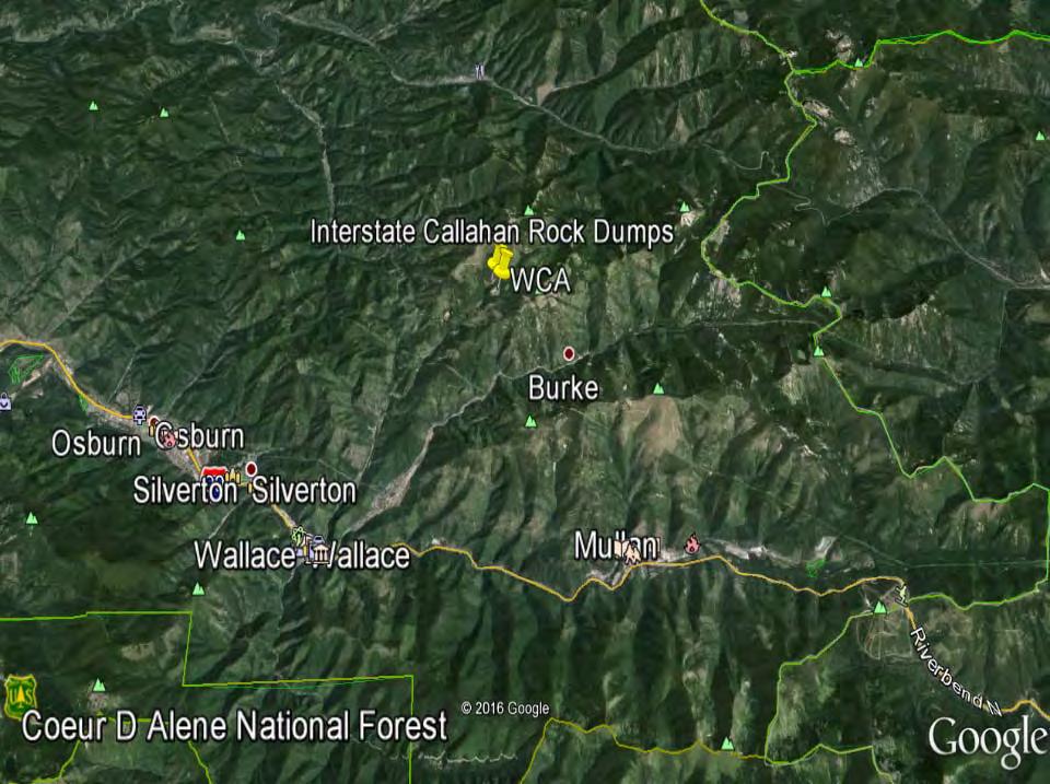
Interstate-Callahan Upper and Lower Rock Dumps RA Construction Project. East Fork Ninemile Creek, Idaho May 3, 2016
|
|
|
- Edgar Washington
- 6 years ago
- Views:
Transcription


1 Interstate-Callahan Upper and Lower Rock Dumps RA Construction Project East Fork Ninemile Creek, Idaho May 3, 2016 Tony Wesche, P.E. Pioneer Technical Services, Inc. and North Wind Group
2 Presentation Topics Site History and Background Design Objectives and Constraints Mine Waste Excavation EFNM Creek and Tributary Reconstruction Revegetation

3


4
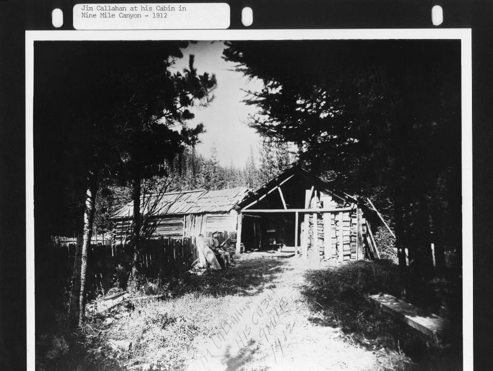
5 History of the Interstate-Callahan 1887 J.F. Callahan filed claim Built cabin and began small scale mining 1906 First ore shipment from Callahan Mine 1912 Consolidated Interstate Mining Company formed 1912 and 1913 Constructed mill and cable tramway 1915 Cable tramway connecting Interstate-Callahan to the railroad Part time mining operations 1920 Callahan Zinc-Lead Company Formed Part Time Mining Operations Period of no mining 1936 Interstate-Callahan Mine Reopened Active Mining Sorted backfill for Lead and Zinc.
6
7 Bunker Hill Superfund Background SUMMARY OF ASARCO SETTLEMENT ~$435 million for cleanup of the CDA Basin Interstate-Callahan RA Construction = ~$4.2 M Coeur d Alene Trust was formed to oversee and manage the money for cleanup under direction from EPA
8 Design Objectives Restore native ground surface within excavated areas to match surrounding native conditions. Restore stream channels, floodplains and riparian areas within the site to conditions similar to upstream reference areas. Minimize operations and maintenance and institutional controls requirements. Maintain recreational use and access consistent with current conditions and reasonably anticipated land use as determined by EPA, other Federal land management agencies, and the current landowner.
9 Design Constraints Short construction season (approximately 120 working days) due to weather conditions Limited area for construction activities and stockpiling of materials Working on steep slopes Coordination with design and construction of the EFNM WCA

10 Mine Waste Excavation
11 Excavation Design Basis Soil boring and test pit data used from 2011 and 2012 Trust site characterization investigations Achieve soil and sediment concentrations less than or equal to 530 mg/kg lead Characterization showed minimal leaching into native soils

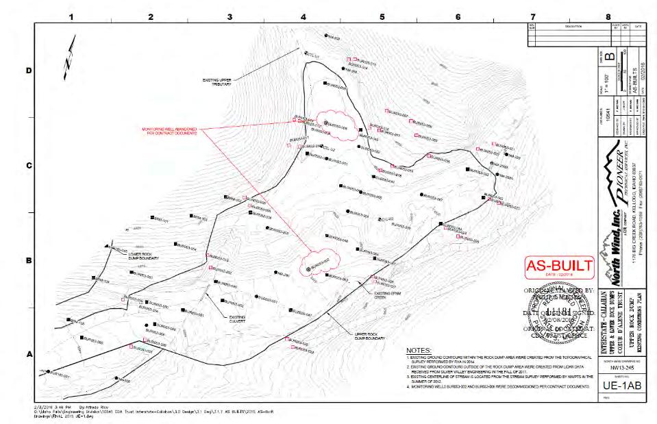
12 Upper Rock Dump

13 Upper Rock Dump Excavation


14 Field Modifications

15 Lower Rock Dump

16 Lower Rock Dump Excavation
17 Field Modifications
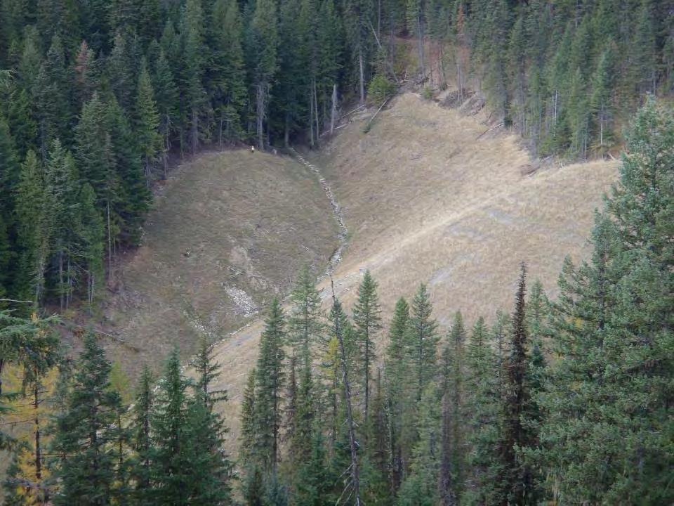
18 Excavation Design Summary Total excavation of 215,928 bank cubic yards of mine waste rock Approximately 27,345 bcy of general fill required for slope establishment, positive drainage and haul road reconstruction Total disturbed footprint was approximately 18 acres

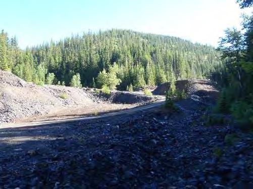

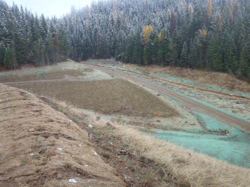
19 Upper Rock Dump Excavation Pre/Post Photographs


20 Upper Rock Dump Excavation Pre/Post Photographs


21 Lower Rock Dump Excavation Pre/Post Photographs


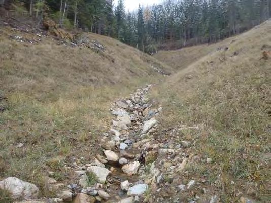
22 EFNM Creek and Tributary Reconstruction
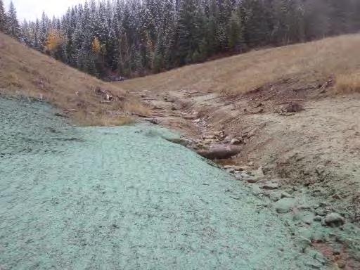
23 Stream/Tributary Design Basis Design based upon upstream reference reach Diversion of EFNM Creek required during construction for waste excavation and stream reconstruction. Grade Controls, Step pools, and run sections Four designed structures incorporated (Rock Cross Vane, Double Log V-Structure, Armored Angled Log Step-Down, and Angled Rock Step Down)


24 EFNM Creek Channel Alignment


25 Grade Control Structure


26 Log Grade Control Structure

27 Incorporating Bedrock during Construction


28 Upper EFNM Creek

29 Lower EFNM Creek


30 Lower Tributary Reconstruction


31 Upper Tributary Reconstruction
32 Stream/Tributary Reconstruction Summary Reconstruction of approximately 1,692 linear feet of EFNM Creek Reconstruction of approximately 1,490 linear feet of Tributaries Installation of 37 Rock Cross Vane Structures in both EFNM Creek and tributaries Installation of 3 Double V-Log Structures 16 Armored Angled Log Step-Down Structures 17 Angled Rock Step-Down Structures 1,800 Riparian tubelings (alders and willow)
33 Revegetation
34 Revegetation Cover Soil (12-inches of imported cover soils from EFNM WCA) Amendment (3% Organic matter and lime incorporation was performed as part of EFNM WCA Construction Activities) Upland and Riparian Seed Mixes (consistent with EFNM basin native plant species) Tubelings (western red cedar, western larch, white pine, and lodgepole pine at tubelings per acre)

35 Locals enjoying dinner
36 Revegetation Summary 19.1 acres of revegetation 16.5 acres of upland seed mix 1.6 acre of riparian seed mix 25,993 cubic yards of amended cover soil 2,262 dry tons of organic amendment 19.1 acres of hydro-mulch 3,620 conifer tubelings 1,800 riparian tubelings 11,001 square yards of erosion control mat
37 Lessons Learned Flexible Designs Flexible Contracting Mechanisms Unit Rate Bids Time and Materials Development of a good working relationship between owner, engineer and contractor results in a successful project Ensure third-party surveyors understand final use for their data Double V-log Grade Control Structures has gradient limitations Use of cleared and grubbed materials, wood debris, and Hydro Straw BFM are viable erosion control methods on steep slopes Organic amended cover soils are needed for successful revegetation Elk love Cedar tubelings


38 THANKS


39 QUESTIONS
Item Name Description Unit of Measure Mobilization Per WSDOT Lump Sum
 Page 1 of 6 DESIGN STANDARDS FOR: MEASUREMENT AND PAYMENT Where bids are utilities for construction, repair or alteration for Public Work park projects, the following bid item descriptions and units of
APPENDIX D: COST ESTIMATES FOR STUDY REACHES
 D-1 APPENDIX D: COST ESTIMATES FOR STUDY REACHES This appendix provides approximate quantity and cost information for the higher-priority improvement measures identified in the reach tables in Appendix
901 - TEMPORARY EROSION AND POLLUTION CONTROL SECTION 901 TEMPORARY EROSION AND POLLUTION CONTROL
 SECTION 901 TEMPORARY EROSION AND POLLUTION CONTROL 901.1 DESCRIPTION Install, maintain and remove temporary erosion and pollution control devices as required during the construction of the project. BID
SOIL EROSION CONTROL PERMIT APPLICATION
 SOIL EROSION CONTROL PERMIT APPLICATION Pursuant to Part 91, Soil Erosion and Sedimentation Control, of Act 451 of the Public Acts of 1994, as amended A Soil Erosion Control Permit is required for earth
STREAMBANK RESTORATION DESIGN
 STREAMBANK RESTORATION DESIGN WITH VINYL SHEET PILE GRADE CONTROL STRUCTURES BRUCE M. PHILLIPS, M.S., P.E. ABSTRACT Grade control structures are an effective channel stabilization measure which can eliminate
DRAFT TECHNICAL SPECIFICATIONS FOR
 DRAFT TECHNICAL SPECIFICATIONS FOR DETROIT RIVER AOC STONY ISLAND HABITAT RESTORATION PROJECT THE DETROIT RIVER, WAYNE COUNTY, MICHIGAN FOR INFORMATION JANUARY, 2016 Prepared for: FRIENDS OF THE DETROIT
Economics of Implementing Two-stage Channels
 2011 A Partnership of USDA NIFA & Land Grant Colleges and Universities Economics of Implementing Two-stage Channels GREAT LAKES REGION Jon Witter, Jessica D Ambrosio, Joe Magner, Andy Ward and Bruce Wilson
East Fork Illinois River Channel and Floodplain Restoration Project
 East Fork Illinois River Channel and Floodplain Restoration Project Wild Rivers Ranger District, Rogue River-Siskiyou National Forest /s/ Joni D. Brazier Date: February 20, 2015 Joni D. Brazier, Forest
Town of Essex, Vermont January, 2017 Standard Specifications For Construction CHAPTER 3 EROSION AND SEDIMENT CONTROL
 CHAPTER 3 EROSION AND SEDIMENT CONTROL CHAPTER 3 EROSION AND SEDIMENT CONTROL Section 300 General Summary All projects constructed within the Town of Essex shall be constructed in strict accordance with
Module 4 Regulatory requirements for Land Disturbing Activities
 Module 4 Regulatory requirements for Land Disturbing Activities MODULE 4 REGULATORY REQUIREMENTS FOR A LDA Module 4a Overview MODULE 4A REGULATORY REQUIREMENTS FOR A LDA ESC Regulations Overview 1990 First
Erosion & Sedimentation Control Policy
 Issue Date 10/22/2010 Page 1 of 8 Erosion & Sedimentation Control Policy Introduction: Soil erosion is the removal of soil by water, wind, ice or gravity and sediment deposition occurs when the rate of
NEW CASTLE CONSERVATION DISTRICT. through. (Name of Municipality) PLAN REVIEW APPLICATION DRAINAGE, STORMWATER MANAGEMENT, EROSION & SEDIMENT CONTROL
 PLAN REVIEW APPLICATION DRAINAGE, STORMWATER MANAGEMENT, EROSION & SEDIMENT CONTROL") NEW CASTLE CONSERVATION DISTRICT through (Name of Municipality) PLAN REVIEW APPLICATION DRAINAGE, STORMWATER MANAGEMENT, EROSION & SEDIMENT CONTROL Office use only: Received by Municipality: Received by
NEW CASTLE CONSERVATION DISTRICT through (Name of Municipality) PLAN REVIEW APPLICATION DRAINAGE, STORMWATER MANAGEMENT, EROSION & SEDIMENT CONTROL Office use only: Received by Municipality: Received by
ACID MINE DRAINAGE TREATMENT IN GREENS RUN BY AN ANOXIC LIMESTONE DRAIN
 ACID MINE DRAINAGE TREATMENT IN GREENS RUN BY AN ANOXIC LIMESTONE DRAIN Introduction Troy Titchenell and Jeff Skousen Anker Energy and West Virginia University From its headwaters in Pocahontas, Randolph
Bond release verification requirements for successful reclamation at Wyoming surface coal mines
 Bond release verification requirements for successful reclamation at Wyoming surface coal mines Dr. Anna Krzyszowska Waitkus Coal bond release procedure in Wyoming Coal bond release verification criteria
LANDFILL CLOSURE PLAN ENTERGY ARKANSAS, INC. INDEPENDENCE PLANT CLASS 3N CCR LANDFILL PERMIT NO S3N-R2 AFIN
 LANDFILL CLOSURE PLAN ENTERGY ARKANSAS, INC. INDEPENDENCE PLANT CLASS 3N CCR LANDFILL PERMIT NO. 0200-S3N-R2 AFIN 32-00042 OCTOBER 12, 2016 LANDFILL CLOSURE PLAN ENTERGY ARKANSAS, INC. INDEPENDENCE PLANT
U.S. ARMY CORPS OF ENGINEERS. Little Rock District
 U.S. ARMY CORPS OF ENGINEERS Little Rock District SEDIMENT AND EROSION CONTROL GUIDELINES FOR PIPELINE PROJECTS Table of Contents 1.0 INTRODUCTION... - 1-2.0 PROJECTS IN WATERS OF THE UNITED STATES...
WEST VIRGINIA DIVISION OF FORESTRY STATE FOREST STANDARDS for LOGGING ROADS AND SKID TRAILS HAUL ROADS
 WEST VIRGINIA DIVISION OF FORESTRY STATE FOREST STANDARDS for LOGGING ROADS AND SKID TRAILS HAUL ROADS The objective of these specifications is to provide the construction requirements for haul roads and
Bunker Hill Mining and Metallurgical Complex, Idaho, Superfund Case Study
 Bunker Hill Mining and Metallurgical Complex, Idaho, Superfund Case Study Revitalization of the Bunker Hill Hillsides and Wetlands This is the story of ecological revitalization at two areas of the Bunker
Understanding Stormwater Pollution Prevention Plans (SWPPPs) (SWPPPS)
 (SWPPPS)") Understanding Stormwater Pollution Prevention Plans (SWPPPs) (SWPPPS) Definitions SWPPP: Storm Water Pollution Prevention Plan BMP: Best Management Practice(s) to control pollution IDNR: Iowa Department
Understanding Stormwater Pollution Prevention Plans (SWPPPs) (SWPPPS) Definitions SWPPP: Storm Water Pollution Prevention Plan BMP: Best Management Practice(s) to control pollution IDNR: Iowa Department
Erosion and Sediment Control Plan for a Timber Harvesting Operation
 3930-FM-WM0155 Rev. 7/2004 Erosion and Sediment Control Plan for a Timber Harvesting Operation 1. GENERAL INFORMATION A. Location Municipality B. Timber sale area = acres Date County C. Landowner Name
OVERVIEW COEUR D ALENE RIVER BASIN. Fisheries Management in the Coeur d Alene River Basin, Idaho and Superfund Legislation
 Fisheries Management in the Coeur d Alene River Basin, Idaho and Superfund Legislation Presented to the Senate Committee on Environment and Public Works Subcommittees on Superfund and Waste Management
Block or Log forms of PAM and PAM blends are manufactured for specific use in drainage waterways to remove suspended particulates from runoff.
 Technical Guidance for the Use of Polyacrylamides (PAM) and PAM Blends for Soil Erosion Control and Storm Water clarification (Courtesy of Applied Polymer Systems, Inc.) Practice Description PAM is a water-soluble
SUBSURFACE INFILTRATION SYSTEM DESCRIPTION. Alternative Names: Sump, Drywell, Infiltration Trench, Infiltration Galleries, Leach Fields
 4.1-d SUBSURFACE INFILTRATION SYSTEM Alternative Names: Sump, Drywell, Infiltration Trench, Infiltration Galleries, Leach Fields BMP DESIGN APPROACH Pollutant Source Control Hydrologic Source Control Stormwater
Mill Street Corridor Assessment/Cleanup Overview
 Mill Street Corridor Assessment/Cleanup Overview Former S. Bent Mill Site Site History Overview Circa 1867 to 1992 - S. Bent Mill Company (furniture manufacturing) Circa early 1900s - expansion of the
TECHNOLOGY OVERVIEW EXCAVATION AND DISPOSAL OF SOLID MINING WASTE
 TECHNOLOGY OVERVIEW EXCAVATION AND DISPOSAL OF SOLID MINING WASTE August 2010 Prepared by The Interstate Technology & Regulatory Council Mining Waste Team Permission is granted to refer to or quote from
Construction Application for Permit (CAP) Instructions
 Instructions") Construction Application for Permit (CAP) Instructions A CAP is required to be completed and submitted to the Wayne Soil & Water Conservation District (SWCD) office for non-farm, earth-disturbing activities
Construction Application for Permit (CAP) Instructions A CAP is required to be completed and submitted to the Wayne Soil & Water Conservation District (SWCD) office for non-farm, earth-disturbing activities
SW-74 SERENOVA PRESERVE SITES 2, 3, 4, 8 MITIGATION PLAN
 SW-74 SERENOVA PRESERVE SITES 2, 3, 4, 8 MITIGATION PLAN BACKGROUND INFORMATION Project SWIM? Aquatic Control? Exotic Control? Mitigation Bank? Type No No No No Mitigation Restoration and enhancement Type
W. Goodrich Jones State Forest. Best Management Practices Virtual Demonstration Tour
 W. Goodrich Jones State Forest Best Management Practices Demonstrations of commonly implemented Texas Forestry BMPs for Water Quality Protection Texas Forest Service Water Resources P.O. Box 310 Lufkin,
Anaconda Smelter, Anaconda, Montana, Superfund Case Study
 Anaconda Smelter, Anaconda, Montana, Superfund Case Study Revitalization of the Upland Areas This is the story of ecological revitalization in the upland areas of the Anaconda Smelter Superfund site (the
Azurite Mine Overview
 Azurite Mine Overview Abandoned Underground Gold Mine, Located in North Central WA on USFS Administered Land Northwest of Mazama, Near Harts Pass Recreation Area & Pacific Crest Trail Remote with Poor
PART 1 GENERAL REQUIREMENTS
 PART 1 GENERAL REQUIREMENTS Contract Closeout Plan 110 Arrow diagram for project close-out...3 Erosion Control 121 Straw bale barrier... 5 122 Silt fence... 7 123 Diversion dike... 9 124 Inlet protection...
RECLAMATION REGULATIONS
 RECLAMATION REGULATIONS 1001. INTRODUCTION a. General. The rules and regulations of this series establish the proper reclamation of the land and soil affected by oil and gas operations and ensure the protection
Timber Sale Appraisal Sunday Passage Sale FG
 Timber Sale Appraisal Sunday Passage Sale FG-341-2018-024- District: Forest Grove Date: August 23, 2017 Cost Summary Conifer Hardwood Total Gross Timber Sale Value $3,295,699.11 $68,708.64 $3,364,407.75
Greenfield Pond B Rehabilitation
 Preliminary Investigation Report Centennial, Colorado November 15, 2011 Prepared for: Liverpool Metropolitan District Prepared by: Stantec Consulting Services, Inc. Table of Contents Executive Summary...
June 1, Dear Mr. Simpson:
 10 Main Street Suite 321 New Paltz, NY 12561 T 845.255.0210 F 845.256.8110 www.willinghamengineering.com 1 June 1, 2016 Mr. Philip T. Simpson Robinson Brog Leinwand Greene Genovese & Gluck, P.C. 875 Third
Honeysuckle Reservoir decommissioning
 Honeysuckle Reservoir decommissioning Christopher Dwyer Earth Tech, PO Box 165 Wangaratta, 3676. Web: www.earthtech.com.au, Email: chris.dwyer@earthtech.com.au Abstract Often significant investment is
Lyon Creek Cedar Way Stormwater Detention Dam Operation and Maintenance Manual
 Lyon Creek Cedar Way Stormwater Detention Dam Operation and Maintenance Manual Prepared by: Mike Shaw Stormwater Program Manager City of Mountlake Terrace January 2010 Section I General Information This
Chapter MINERAL EXTRACTION AND MINING OPERATIONS
 Chapter 17.31 MINERAL EXTRACTION AND MINING OPERATIONS Sections: 17.31.010 Purpose 17.31.020 Procedure for Extraction and Rehabilitation Requests 17.31.030 Operation and Rehabilitation Standards for all
Closure Plan Brame Fly Ash Pond
 Brame Fly Ash Pond CLECO Corporation Rodemacher Unit 2 Project No. 90965 Revision 0 10/14/2016 Brame Fly Ash Pond prepared for CLECO Corporation Rodemacher Unit 2 Rapides Parish, Louisiana Project No.
COUNTY OF NEVADA COMMUNITY DEVELOPMENT AGENCY NEVADA COUNTY CDA GUIDELINES FOR ASH AND BURN DEBRIS CLEAN UP AND REMOVAL AFTER A FIRE
 COUNTY OF NEVADA COMMUNITY DEVELOPMENT AGENCY Environmental Health Department 950 MAIDU AVENUE, SUITE 170 NEVADA CITY, CA 95959-8617 (530) 265-1222 FAX (530) 265-9853 http://mynevadacounty.com Amy Irani,
719 Griswold, Suite 820 Detroit, MI DANVERS POND DAM REMOVAL AND STREAM RESTORATION PROJECT
 Great Lakes Restoration Initiative Grant Final Report US EPA Grant GL 00E006 43 October, 2013 Valley Woods Wetland Southfield Lola Valley Grow Zone Wayne County Parks Venoy Park Grow Zone Wayne County
SECTION TRENCHING & BACKFILLING
 SECTION 02225 - TRENCHING & BACKFILLING 1.0 GENERAL 1.1 Work included in this Section includes trenching and backfilling for underground pipelines and related structures only. 1.2 Reference Specifications
Intermittent Stream Reclamation
 Reclamation About Mosaic Reclamation > In carrying out its mission to help the world grow the food it needs, Mosaic couples recovery of phosphate resources with respect of the phosphate-rich land that
Closure Plan Ash Disposal Area PGE Boardman Power Plant
 FIRST ISSUE REVISION 0 Closure Plan Ash Disposal Area PGE Boardman Power Plant Prepared for Portland General Electric September 2015 2020 SW 4th Avenue, Suite 300 Portland, Oregon 97201 This document was
Timber Sale Appraisal Shepherds Pie Sale cost summary. Conifer Hardwood Total. Gross Timber Sale Value $2,013, $13,263.
 Timber Sale Appraisal Shepherds Pie Sale 341-14-23 District: N Cascade Date: January 14, 2014 cost summary Conifer Hardwood Total Gross Timber Sale Value $2,013,923.22 $13,263.00 $2,027,186.22 Project
Mechanical Site Preparation
 Mechanical Site Preparation 1 Mechanical Site Preparation Introduction...3 CONTENTS The Benefits of Guidelines...3 Considerations...5 Design Outcomes To Maintain Soil Productivity...6 Planning...7 Planning
FINDINGS: Olsson used a three-step analysis strategy to develop a benefit cost ratio that would indicate the relative feasibility of this project.
 EXECUTIVE SUMMARY FINDINGS: Based on the results of this feasibility study, the Platte Republican Diversion Project would be cost-effective. With minimal improvements to the channel, and the existing bridge
REROUTING DRAINAGE SYSTEMS
 MINNESOTA WETLAND RESTORATION GUIDE REROUTING DRAINAGE SYSTEMS TECHNICAL GUIDANCE DOCUMENT Document No.: WRG 4A-4 Publication Date: 10/14/2015 Table of Contents Introduction Application Design Considerations
C. Foundation stabilization for pipe and utility structures.
 PART 1 - GENERAL 1.1 SECTION INCLUDES A. Excavating, backfilling, and compacting for utilities, including pipe, structures, and appurtenances. B. Control of water in trenches. C. Foundation stabilization
TOWN OF MOUNT PLEASANT WESTCHESTER COUNTY, NEW YORK
 TOWN OF MOUNT PLEASANT WESTCHESTER COUNTY, NEW YORK COST EVALUATION FOR ROLLING HILLS AREA WATER MAIN EXTENSION PROFESSIONAL CONSULTING, LLC. Octagon 10, Office Center 1719 Route 10, Suite 225 Parsippany,
Final Report: 1999 South Fork Garcia River Watershed Erosion Control and Prevention Project, SB271 Road Upgrading and Decommissioning Project
 FINAL REPORT Final Report: 1999 South Fork Garcia River Watershed Erosion Control and Prevention Project, SB271 Road Upgrading and Decommissioning Project prepared for: California Department of Fish and
Private Sewage Permit Application
 Kneehill County 1600-2 Street NW Three Hills, AB T0M 2A0 Phone: 403-443-5541 Fax: 403-443-5115 Private Sewage Permit Application Permit Number Permit Type: Owner Contractor Development Permit Number: Application
Project Goals and Scoping
 Prepared for: Boulder County, Colorado Flood Planning & Preliminary Design Services for South St. Vrain Creek Restoration at Hall Ranch and Scoping May 24, 2016 Meeting with General Public In association
Habitat Grant Projects Clinton River Watershed
 Habitat Grant Projects Clinton River Watershed L Y N N E S E Y M O U R E N V I R O N M E N T A L E N G I N E E R O F F I C E O F T H E M A C O M B C O U N T Y P U B L I C W O R K S C O M M I S S I O N
Small Project Proposal
 Combined Scoping and Notice and Comment Document Small Project Proposal USDA Forest Service Fishlake National Forest Beaver Ranger District Sevier County, Utah The purpose of this document is to inform
Summary Report S. B. 271 Watershed Assessment for a portion of Mill Creek, Tributary to the Navarro River
 scanned for KRIS Summary Report 1999 S. B. 271 Watershed Assessment for a portion of Mill Creek, Tributary to the Navarro River prepared for Daniel T. Sicular, and the Mendocino County Resource Conservation
Boise City Public Works General Drainage Plan Review Requirements Checklist
 Boise City Public Works General Drainage Plan Review Requirements Checklist Development Name Bldg. Permit # Drainage Reviewer Site Address Initial Review Date ODI Number Designer Company Name Treated Acres
Roscommon County Soil Erosion and Sedimentation Control (SESC) Program Guide
 Program Guide") Roscommon County SESC Program 500 Lake Street Roscommon, Michigan 48653 Phone: 989-275-8323 Fax: 989-275-8640 Roscommon County Soil Erosion and Sedimentation Control (SESC) Program Guide INCLUDED ATTACHMENTS
Roscommon County SESC Program 500 Lake Street Roscommon, Michigan 48653 Phone: 989-275-8323 Fax: 989-275-8640 Roscommon County Soil Erosion and Sedimentation Control (SESC) Program Guide INCLUDED ATTACHMENTS
Temporary Watercourse Crossing: Culverts
 Temporary Watercourse Crossing: Culverts DRAINAGE CONTROL TECHNIQUE Low Gradient Velocity Control Short Term Steep Gradient Channel Lining Medium-Long Term Outlet Control Soil Treatment Permanent Symbol
The project will be conducted in partnership with the Nez Perce Tribe.
 DECISION MEMO Tributary to Brushy Fork Culvert Replacements Private Land USDA Forest Service, Northern Region Powell Ranger District Nez Perce Clearwater National Forests Idaho County, Idaho I. Decision
INSTRUCTIONS FOR PREPARATION OF APPLICATION FORM FOR SURFACE MINING PERMIT AND/OR RECLAMATION PLAN
 INSTRUCTIONS FOR PREPARATION OF APPLICATION FORM FOR SURFACE MINING PERMIT AND/OR RECLAMATION PLAN KERN COUNTY PLANNING AND COMMUNITY DEVELOPMENT DEPARTMENT 2700 "M" Street, Suite 100 Bakersfield, CA 93301
GUIDE TO THE DEVELOPMENT OF A MINING AND RECLAMATION PLAN IN NEW BRUNSWICK
 PROVINCE OF NEW BRUNSWICK DEPARTMENT OF ENERGY AND RESOURCE DEVELOPMENT Minerals and Petroleum Development Branch GUIDE TO THE DEVELOPMENT OF A MINING AND RECLAMATION PLAN IN NEW BRUNSWICK Guide to the
5. Partially filled fuel tanks within the building shall be pumped empty. The oil and tanks shall be removed and deposed of in a legal manner.
 Page 1 of 1. A pre bid site walk though was held at the site, 200 West Street, Ware MA, at 2:00pm August 24, 2011. The following attended: a. Chief Thomas Coulombe Ware Fire Department b. Mr. Thomas Martens
TECHNICAL MEMORANDUM
 FOR INTERNAL DISCUSSION PURPOSES ONLY TECHNICAL MEMORANDUM TO: Augusta Resource Corp. ATTENTION: Jamie Sturgess FROM: Troy Meyer Project Manager, Vector Colorado LLC (Vector) DATE: June 5, 2006 SUBJECT:
CHAPTER 62B-34 GENERAL PERMITS FOR ACTIVITIES SEAWARD OF THE COASTAL CONSTRUCTION CONTROL LINE
 1 2 CHAPTER 62B-34 GENERAL PERMITS FOR ACTIVITIES SEAWARD OF THE COASTAL CONSTRUCTION CONTROL LINE 3 4 5 6 7 8 9 10 11 12 13 14 15 62B-34.010 62B-34.030 62B-34.040 62B-34.050 62B-34.055 62B-34.060 62B-34.070
10:00 AM, Wednesday, April 8, 2015
 NOTICE OF MANDATORY PRE-BID CONFERENCE WILL BE HELD AT 10:00 AM, Wednesday, April 8, 2015 IN ROOM 16, CITY HALL BUILDING, 101 NORTH MAIN STREET WINSTON-SALEM, NORTH CAROLINA The purpose of this conference
Cass County Soil Erosion & Sedimentation Control Program
 Cass County Soil Erosion & Sedimentation Control Program Both residents and visitors of Cass County enjoy the beauty of over 250 lakes and ponds, along with numerous streams, creeks, and wetlands that
St. Vrain Creek Reach 3 Restoration Construction Specifications Highway 36 to Crane Hollow Road Boulder County, Colorado
 Highway 36 to Crane Hollow Road Boulder County, Colorado Prepared for: Colorado Water Conservation Board Department of Local Affairs CDBG-DR Prepared by: and 1600 Specht Point Road, Suite 209 Fort Collins,
Public Notice ISSUED: June 29, 2017 EXPIRES: July 31, 2017
 SPONSOR: Gary Pestorious Public Notice ISSUED: June 29, 2017 EXPIRES: July 31, 2017 REFER TO: 2012-01634-DAS SECTION:404 - Clean Water Act 1. WETLAND COMPENSATORY MITIGATION BANK PROPOSAL: Pickerel Lake
RESTORATION, CLOSURE & RECLAMATION. Ch. 14 of the PRO
 1 RESTORATION, CLOSURE & RECLAMATION Ch. 14 of the PRO FORWARD LOOKING STATEMENTS Statements contained in this presentation that are not historical facts are forward-looking information or forward-looking
Attachment D-1: Civil/Structural Scope of Work
 Attachment D-1: Civil/Structural Scope of Work Project: Location: Targa Sound Renewable Fuels Project Tacoma, WA Prepared by: NORWEST ENGINEERING Consulting Engineers 4110 N.E. 122 nd Avenue, Portland,
Construction of Dariali HEPP. Reinstatement Plan
 Construction of Dariali HEPP Reinstatement Plan 2016 Table of Content 1. Introduction... 3 2. Site Clean-up... 4 3. Headwork Site Reinstatement... 4 4. Reinstatement Of The Pipeline Corridor.9 5. Cable
7 Mineral and Energy Resources
 7 Mineral and Energy Resources This chapter examines Humboldt County s mineral (including sand and gravel extraction) and energy (oil, gas, and geothermal) resources. Existing General Plan policies and
Blanche Park Reservoir Decision Notice and Finding of No Significant Impact
 Blanche Park Reservoir Decision Notice and Finding of No Significant Impact U.S. Forest Service Grand Mesa, Uncompahgre, and Gunnison National Forests Delta County, Colorado INTRODUCTION The Grand Mesa
UMD Storm Water Program Construction Requirements. Greg Archer, MBA Environmental Compliance Specialist
 UMD Storm Water Program Construction Requirements Greg Archer, MBA Environmental Compliance Specialist Phase 2 Regulatory Overview Dec. 1999 EPA issues Phase 2 Federal Register Municipalities (MS4) from
LANDFILL CLOSURE PLAN PLUM POINT ENERGY STATION CLASS 3N CCR LANDFILL PERMIT NO S3N AFIN:
 LANDFILL CLOSURE PLAN PLUM POINT ENERGY STATION CLASS 3N CCR LANDFILL PERMIT NO. 0303-S3N AFIN: 47-00461 OCTOBER 14, 2016 LANDFILL CLOSURE PLAN PLUM POINT ENERGY STATION CLASS 3N CCR LANDFILL PERMIT NO.
Advisory Planning Commission September 27, 2016 Page 6 of 27
 Page 6 of 27 B. Quarry Road Addition Applicant Name: United Properties Development LLC, Rick McKelvey Location: 1555 Yankee Doodle Road; Application: Rezoning A Rezoning from A, Agriculture to PD, Planned
PROJECT INFORMATION AMEREN POWERLINE RECONSTRUCTION PROJECT April 2014
 PROJECT INFORMATION AMEREN POWERLINE RECONSTRUCTION PROJECT April 2014 The United States Forest Service (USFS), Shawnee National Forest (SNF), is analyzing a request from Ameren Services (Ameren), a group
DEPARTMENT OF ENVIRONMENTAL PROTECTION Bureau of Water Quality Protection. Design Criteria - Wetlands Replacement/Monitoring
 DEPARTMENT OF ENVIRONMENTAL PROTECTION Bureau of Water Quality Protection DOCUMENT NUMBER: 363-0300-001 TITLE: Design Criteria - Wetlands Replacement/Monitoring EFFECTIVE DATE: February 11, 1997 AUTHORITY:
Constructed Wetland Pond T-8
 Constructed Wetland Pond T-8 Description A constructed wetlands pond is a shallow retention pond designed to permit the growth of wetland plants such as rushes, willows, and cattails. Constructed wetlands
ECSI Number: Responsible Party: Klamath County. QTime Number: Entry Date: 9/22/04 (VCP)
") ECSI Number: 1213 Responsible Party: Klamath County QTime Number: 37941 Entry Date: 9/22/04 (VCP) Proposed Remedial Action Staff Report - Addendum Chiloquin Forest Products Chiloquin, Klamath County, Oregon
ECSI Number: 1213 Responsible Party: Klamath County QTime Number: 37941 Entry Date: 9/22/04 (VCP) Proposed Remedial Action Staff Report - Addendum Chiloquin Forest Products Chiloquin, Klamath County, Oregon
File No Supplemental November Geotechnical and Environmental Consulting Engineers
 Supplemental Information & Geotechnical Recommendations Proposed New Solar Valley Location B (East of Building No. 7) Cañada Community College 4200 Farm Hill Boulevard Submitted to: Mr. Peter Hempel Construction
Chapter 12 Erosion and Sediment Control
 Chapter 12 Erosion and Sediment Control U30012.DOC 03/05/10 Chapter 12 Erosion and Sediment Control Table of Contents Section Topic Page 12.1 Introduction 12-1 12.1.1 General 12-1 12.1.1.1 Exemptions 12-2
PUBLIC NOTICE. REPLY TO: Denver Regulatory Office 9307 South Wadsworth Blvd 30 DAY NOTICE Littleton, CO FAX (303)
") PUBLIC NOTICE US Army Corps of Engineers Omaha District Application No: NWO-2017-01366-DEN Project: Douglas Lane Tributary Stabilization Project Applicant: Town of Castle Rock Waterway: Douglas Lane Tributary
PUBLIC NOTICE US Army Corps of Engineers Omaha District Application No: NWO-2017-01366-DEN Project: Douglas Lane Tributary Stabilization Project Applicant: Town of Castle Rock Waterway: Douglas Lane Tributary
Beneficial Use of Fly Ash for an Airport Safety Way Extension over a Multiple Year Project
 World of Coal Ash (WOCA) Conference - May 9-12, 2011, in Denver, CO, USA http://www.flyash.info/ Beneficial Use of Fly Ash for an Airport Safety Way Extension over a Multiple Year Project John M. Trast,
PALMERTON ZINC PILE PALMERTON, CARBON COUNTY, PENNSYLVANIA Superfund Case Study
 ECOLOGICAL REVITALIZATION OF CONTAMINATED SITES CASE STUDY This case study is part of a series focused on ecological revitalization as part of contaminated site remediation and reuse; these case studies
EFFECT OF UPSTREAM DEVELOPMENT ON THE CLEAR CREEK AREA
 EFFECT OF UPSTREAM DEVELOPMENT ON THE CLEAR CREEK AREA Technical Memorandum Farming in the Floodplain Project Prepared for May 2017 PCC Farmland Trust Photo credit: Google Earth TABLE OF CONTENTS Page
Sample Timber Sale Agreement
 Sample Timber Sale Agreement I (Name) of (Address), hereinafter called the Contractor, agree to purchase from: (Name) of (Address), hereinafter called the Seller, the designated timber from the area described
South St. Vrain / Hall Meadows Restoration Planning August 20, 2015
 South St. Vrain / Hall Meadows Restoration Planning August 20, 2015 Agenda Introductions Purpose & Goals of Meeting Planning Area Master Plan Restoration Planning: Cost Estimates, Grants, Scope, Timeline
US Steel/Spirit Lake Sediment Cleanup Update for River Corridor Coalition
 US Steel/Spirit Lake Sediment Cleanup Update for River Corridor Coalition Erin Endsley, Project Manager Mike Bares, Technical Analyst Minnesota Pollution Control Agency August 26, 2015 Outline Site history
STATE OF OHIO DEPARTMENT OF TRANSPORTATION SUPPLEMENTAL SPECIFICATION 836 SEEDING AND EROSION CONTROL WITH TURF REINFORCING MAT January 18, 2013
 836.01 Description 836.02 Materials 836.03 Construction 836.04 Maintenance 836.05 Method of Measurement 836.06 Basis of Payment STATE OF OHIO DEPARTMENT OF TRANSPORTATION SUPPLEMENTAL SPECIFICATION 836
PG&E Transmission Lines Hazard Tree Removal and Salvage Project
 PG&E Transmission Lines Hazard Tree Removal and Salvage Project Hydrology Effects Analysis Report Zack Mondry, Hydrologist (PH) USFS ACT2 Enterprise Unit Executive Summary Analysis of the proposed Humboldt/Trinity
Planning and Combination (Planning and Acquisition) Project Proposal
 Project Proposal") Planning and Combination (Planning and Acquisition) Project Proposal Project Number 15-1308 Project Name Asotin County Geomorphic/Watershed Assessment Sponsor Asotin County Conservation District List all
Planning and Combination (Planning and Acquisition) Project Proposal Project Number 15-1308 Project Name Asotin County Geomorphic/Watershed Assessment Sponsor Asotin County Conservation District List all
SECTION Section Excavation and Backfill For Structures Section Embedment and Base Course Aggregate
 SECTION 2110 EXCAVATION AND EMBANKMENT 1.00 GENERAL 1.01 Scope. Work to be performed under this section shall include all labor, equipment, materials and miscellaneous items necessary to perform all clearing
Avista Dam Relicensing Factsheet Commenting on the Draft License Application
 Avista Dam Relicensing Factsheet Commenting on the Draft License Application Please Note: This is intended for informational purposes only and does not constitute legal advice. The life of every river
Some excerpts from the federal Surface Mining Control and Reclamation Act of 1977 (SMCRA), passed August 3, 1977
, passed August 3, 1977") Some excerpts from the federal Surface Mining Control and Reclamation Act of 1977 (SMCRA), passed August 3, 1977 PURPOSES [30 U.S.C. 1202] SEC. 102. It is the purpose of this Act to - (a) establish a nationwide
Some excerpts from the federal Surface Mining Control and Reclamation Act of 1977 (SMCRA), passed August 3, 1977 PURPOSES [30 U.S.C. 1202] SEC. 102. It is the purpose of this Act to - (a) establish a nationwide
Niagara Falls Storage Site Safety Measures During Remediation
 Niagara Falls Storage Site Safety Measures During Remediation On-Site Worker Protection Community and Environmental Protection Transportation and Disposal Safety Fully enclosed Retrieval Facility Regular
Design and Implementing Temporary Erosion Prevention BMPs
 Design and Implementing Temporary Erosion Prevention BMPs 2015 Annual MECA Conference Duluth Convention Center March 11, 2015 Dwayne Stenlund, MSc, CPESC MNDOT/OES Planning for the Erosion Process Preservation
Sterrett Passive Treatment System Irwin Township Venango County Project Narrative
 Sterrett Passive Treatment System Irwin Township Venango County Project Narrative Project Overview Project site is located in Irwin Township Venango County. Access to the site will be off of Burns Rd 1
Notice No Closing Date: May 12, 2017
 Public Notice U.S. Army Corps of Engineers Pittsburgh District In Reply Refer to Notice No. below US Army Corps of Engineers, Pittsburgh District 1000 Liberty Avenue Pittsburgh, PA 15222-4186 Application