E&S PLANS. Avoiding Common Deficiencies
|
|
|
- George O’Brien’
- 6 years ago
- Views:
Transcription
1 E&S PLANS Avoiding Common Deficiencies
2 E&S Plan General 102.4(b)(4) E&S Plan must be separate from PCSM Plan & labeled E&S or Erosion and Sediment Control Plan Must be final plan for construction Statements such as Not for bidding or Not for Construction may not be placed on these drawings Documentation provided that E&S Plan prepared by person trained & experienced in E&S design methods & techniques applicable to size & scope of project
3 E&S Plan General 102.4(b)(4) E&S Plan must be separate from PCSM Plan & labeled E&S or Erosion and Sediment Control Plan Must be final plan for construction Documentation provided that E&S Plan prepared by person trained & experienced in E&S design methods & techniques applicable to size & scope of project
4 E&S Plan General 102.4(b)(4) E&S Plan must minimize extent & duration of earth disturbance Must maximize protection of existing drainage features & vegetation Must minimize soil compaction Or utilize other measures or controls that prevent or minimize generation of increased stormwater runoff

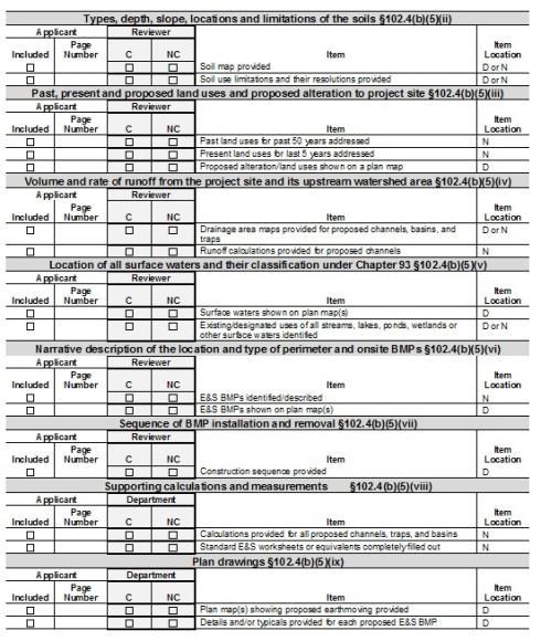
5 Components of an E&S Plan The 15 Items from Chapter 102.4(b)(5)
6 Components of an E&S Plan 1. Existing topographic features of project site & & immediate surrounding area 2. Types, depth, slope, locations & limitations of soils 3. Characteristics of earth disturbance activity, including past, present & proposed land uses & proposed alteration to project site 4. Volume & rate of runoff from project site & upstream watershed area
7 Components of an E&S Plan 5. Location of all surface waters, which may receive runoff within or from project site & classification under Chapter Narrative description of location & type of perimeter & on site BMPs used before, during, & after earth disturbance activity 7. Sequence of BMP installation & removal 8. Supporting calculations & measurements 9. Plan drawings
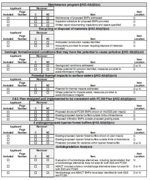
8 Components of an E&S Plan 10. Maintenance program 11. Procedures which ensure proper measures for recycling or disposal of materials associated with or from project site 12. Identification of natural occurring geologic formations or soil conditions that may have potential to cause pollution 13. Identification of potential thermal impacts to surface waters
9 Components of an E&S Plan 14. E&S Plan designed & implemented to be consistent with Post Construction Stormwater Management (PCSM) 15. Identification of existing & proposed riparian forest buffers

10 Complete Plan Checklist

11 Technical Review Checklist
12 Existing topographic features 102.4(b)(5)(i) Legible topographic map(s) of the project site provided All letters & numbers used on plans should be readable without magnification Symbols used should be readily distinguishable from each other, & clutter avoided Information pertinent to E&S plan should be shown on plan maps & drawings All other information should be omitted
13 Not a legible Map
14 Better
15 Existing topographic features 102.4(b)(5)(i) Name of plan designer along with his/her contact information should be provided All maps & drawings should be clearly labeled & dated Revised maps should have date of each revision shown For permitted sites, sufficient space should be provided on top sheet for approval stamp & signature of reviewing agency
16 Existing topographic features 102.4(b)(5)(i) At least one set of maps & drawings submitted to any agency for review should be full size For linear projects submit composite plan map showing entire project, or major portions thereof, proposed contours, E&S BMPs, & staging or work area boundaries Appendix D in E&S Manual provides further guidance
17 Existing topographic features 102.4(b)(5)(i) Common deficiencies: Type of cover Forest Meadow Lawn Abandoned Surface Mine Pavement Sufficient surrounding area Tributary drainage areas & receiving watercourses If beyond coverage of plan maps, may be shown on USGS topographic map
(5)(i) Legible location map")

18 Existing topographic features 102.4(b)(5)(i) Legible location map (USGS quadrangle) provided Location map should be an insert on plan drawings
19 Soils Information 102.4(b)(5)(ii) Locations of soils may be delineated on plan maps or on separate site map Legible photocopy of portion of NRCS website maps (or Penn State website maps) on which proposed project can be clearly shown may also be used Locations of all proposed sediment basins & traps should be shown on any separate or NRCS maps
(5)(ii) Typical plan map showing")
20 Soils Information 102.4(b)(5)(ii) Typical plan map showing soil boundaries
(5)(ii) Typical soil map")
21 Soils Information 102.4(b)(5)(ii) Typical soil map from website
22 Soils Use Limitations Data on physical characteristics of soils, such as texture, resistance to erosion & suitability for intended use to be included in narrative Only limitations relevant to proposed project should be cited Appendix E lists some of most common soil use limitations for soils in Pennsylvania
23 Soils Use Limitations TABLE E.1 LIMITATIONS OF PENNSYLVANIA SOILS PERTAINING TO EARTHMOVING PROJECTS (Absence of an X does not mean No Potential Limitation ) NOTE: THIS IS NOT NECESSARILY AN ALL-INCLUSIVE LIST. SOIL NAME CUTBANKS CAVE CORROSIVE TO CONCRETE\STEEL DROUGHTY EASILY ERODIBLE FLOODING DEPTH TO SATURATED ZONE/ SEASONAL HIGH WATER TABLE HYDRIC/ HYDRIC INCLUSIONS LOW STRENGTH / LANDSLIDE PRONE SLOW PERCOLATION PIPING POOR SOURCE OF TOPSOIL FROST ACTION SHRINK - SWELL POTENTIAL SINKHOLE PONDING WETNESS Abbottstown X C/S X X X X X X X X X Aeric Epiaquents X C/S X X X X X X Albrights X C/S X X X X X X X X X X Alden X C/S X X X X X X X X X X Aldino X C/S X X X X X X Allegheny X C X X X X X X X Allenwood X C/S X X X X X X Allis X X X X X X X X X X X Alluvial Land X C/S X X X X X X X X X Alton X C X X X X Alvira X C/S X X X X X X X X X X Amwell X C/S X X X X X X X Andover X C/S X X X X X X X X X X Aquepts X C/S X X X X X X X X X Aquults X C/S X X X X X X X X X Arents X Arendtsville X C X X X X X X X Armagh X C/S X X X X X X X X X Arnot X C X X X X X X

24 Soils Use Limitations Simply copying Appendix E into narrative NOT SUFFICIENT to meet requirements of this section Means to address identified soils limitations should be included on drawings
25 Past, Present and Proposed Land Uses Past land uses = actual land use(s) of project site for past 50 years (or longer if known) Not just zoning Present land uses = dominant land uses of project site for 5 years preceding Not just zoning For sites requiring an NPDES permit, contained in completed NOI For non-permitted sites, should be included in narrative
26 Volume & Rate of Runoff Maximum potential drainage area to a BMP at any stage of the project should be used to determine required design capacity Rational Method & Modified Rational Method may not be used to calculate water quality, infiltration, or capture volumes for PCSM BMPs
27 Volume & Rate of Runoff Alterations to drainage patterns, impervious coverage or other watershed characteristics may necessitate Off-Site Stability Analysis Stream stability analysis necessary where discharges anticipated to overburden receiving stream (most notably headwaters) For increase in rate or volume to receiving waterway >10%, stream stability analysis should be included in narrative addressing impact of discharge on watercourse s ability to resist erosion
28 Receiving Surface Waters All streams in Pennsylvania are classified based on designated & existing water uses & water quality criteria Designated uses for surface waters are found in 25 Pa. Code 93.9a 93.9z Link: apter93/chap93toc.html
29 Receiving Surface Waters Existing uses of surface waters usually same as designated use, except where DEP has accepted information that particular water body actually attains a more stringent water use than designated use Existing uses protected pursuant to 25 Pa. Code 93.4a 93.4c. Existing uses may be obtained from DEP s website at:
30 HQ & EV Waters For discharges to High Quality [HQ] or Exceptional Value [EV]) waters, more stringent criteria used to design BMPs Nondischarge alternatives are to be used wherever possible If during 2-year/24-hour storm event, not possible to avoid increasing rate or volume of runoff from disturbed areas to HQ or EV waters, ABACT BMPs must be used to fullest extent possible
31 Narrative Description of BMPs For permitted sites, provided when NOI properly completed Otherwise should be included in narrative
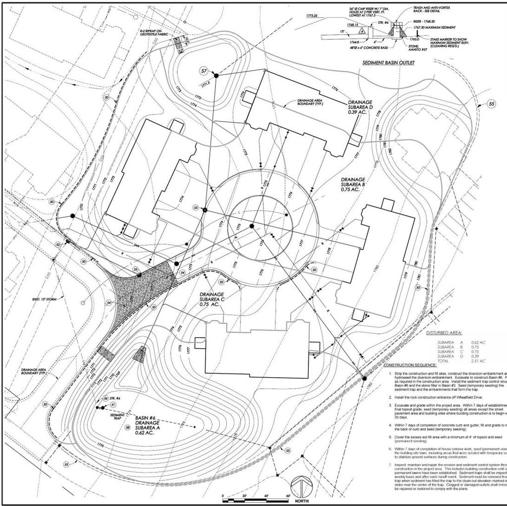
32 Sequence of BMP Installation & Removal Complete schedule of installation & removal of erosion control BMPs as they relate to various phases of earthmoving activities Minimize time of disturbance without unnecessarily restricting construction process Site-specific Appropriate E&S BMPs to be in place & functional before earth disturbance occurs within any given drainage area Chapter 2 provides additional guidance on BMP sequencing
33 Supporting Calculations Narrative should contain: Drainage areas (copies of work maps) Anticipated flow rates & velocity Proposed method of stabilization (channel liners) Required & design storage volumes Discharge rates & volumes Standard worksheets in Appendix B of Manual Use of standard worksheets recommended in order to expedite plan reviews Failure to provide all information requested by appropriate worksheet(s) constitutes administrative incompleteness
34 Standard Worksheets

35 Plan Drawings Locations of BMPs should be shown on map(s)

36 Plan Drawings Construction details & specifications for BMPs should be included on plan drawings
37 Plan Drawings Standard construction details from the Manual may be used CADD details available at : /community/stormwater_management/21377 Many standard details have attached notes in bold type - these notes are part of that detail Many details & standard worksheets contain tables of dimensions that should be copied onto E&S plan drawings
38 Standard Notes Appendix C contains standard notes that should be placed on plan drawings Optional notes also provided & should be used where appropriate Additional notes may be added as needed so long as they do not contradict standard notes, details, sequence, or maintenance requirements
39 Temporary Access Roads Construct only as much road as necessary Minimize clearing Keep road width to minimum Terminal Points - Locate start & end of road system using best access that is safe & visible from public roads Grades Max slope of 10 % & min of 2 % easiest to maintain - Follow contour as much as possible Topography - Avoid steep slopes wherever possible


40 Temporary Access Roads Often primary source of sediment pollution especially during early stages of construction
41 Temporary Access Roads Drainage - use crowned or insloped surfaces & install ditch relief culverts at intervals shown in Table 3.3 or 3.4 (Provide outlet protection) Grading - Minimize cuts & fills work Obstacles - go around springs, seeps, wetlands, poor drainage areas, ledges, & rocky areas wherever possible Soils- Design for soil texture, drainage class, & slope position as outlined in Appendix E
42 Temporary Access Roads Distances from Streams Maintain buffer areas along stream corridors (Wherever sufficient filter strips not possible between roadways & receiving waters, install BMPs, such as wood chip berms, silt fence, etc.) Stream Crossings - Minimize number of stream crossings Cross at 90 O angle & approach stream at as gentle a slope as possible Consider all stream crossings temporary Only bridges or culverts No fords
43 Temporary Access Roads Old roads - use existing roads wherever possible - carefully evaluate road s suitability for upgrading Floodways & wetlands Avoid encroaching on wetlands Roadway construction within floodways (typically 50 ft from top of streambank) & wetlands require encroachment permits
44 Temporary Access Roads Water control structures - Carefully plan use of broad-based dips, waterbars, culverts, & ditches to maintain existing flow patterns & minimize amount of runoff being conveyed by roadways & roadside ditches.

45 Common Problems Access How will contractor access proposed BMP locations? Large compost socks

46 Common Problems Access How will contractor access proposed BMP locations? Large compost socks Super Silt Fence - post hole drills

47 Common Problems Access How will contractor access proposed BMP locations? Large compost socks Super Silt Fence - post hole drills Large Riprap

 Pooled water also a Slope Stability")
48 Channels Align all channels & berms to provide positive drainage throughout Avoid sharp turns, high angles of confluence, & very low gradients (< 1% bed slope) Pooled water also a Slope Stability issue


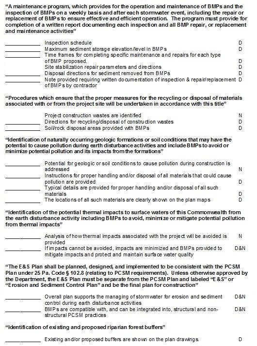
49 Channels Align all channels & berms to provide positive drainage throughout Avoid sharp turns, high angles of confluence, & very low gradients (< 1% bed slope) Provide suitable protective linings Use of check dams is not acceptable alternative to properly designed channel lining
50 Channels Align all channels & berms to provide positive drainage throughout Avoid sharp turns, high angles of confluence, & very low gradients (< 1% bed slope) Provide suitable protective linings Use of check dams is not an acceptable alternative to a properly designed channel lining Provide adequately sized temporary crossing pipe where needed for construction traffic
51 Diversion Channels Do not cut old growth trees to put in a diversion channel unless absolutely necessary Do not locate diversions on steep slopes Do not use diversions where there is no good outlet (Earthen level spreaders are not a good outlet)
52 Basins & Traps Not enough guidance on construction of embankments (See Chapters 7 & 8 in E&S Manual) Keyways Compaction Stabilization Details Water-tight connections Anti-seep collars Critical dimensions & elevations Design of outlet channels


53 Common Problems Conflicts with existing/proposed utilities


54 Common Problems Access How will contractor access proposed locations? Conflicts with existing/proposed utilities Wetland/stream encroachments


55 Common Problems Access How will contractor access proposed locations? Conflicts with existing/proposed utilities Wetland/stream encroachments Unsuitable soils not addressed Low Shear Strength Piping


56 Outlet Protection Do not use Figure 9.3 or 9.4 to design Riprap Aprons below Box Culverts
57 Outlet Protection Consider using other forms of outlet protection Flow Transition Mats Stilling Basins Stilling Wells Drop Structures T-Outlets (see Jim or Kathy for detail) Infiltration Berms (low volume see Stormwater Manual)


58 Stabilization Problems Revegetation not adequately addressed Unsuitable soil conditions Seed mixtures not compatible with site conditions No soil testing Too much dependence on hydroseeding Blanketing not provided where needed


59 BMP Retirement Problems Removal/conversion of Temporary BMPs not adequately addressed Definition of vegetative stabilization unclear Removal of temporary BMPs not specified Method of converting temporary BMPs to permanent BMPs not specified
60 Maintenance Both temporary & permanent BMPs Include schedule for inspection of various BMPs after each runoff event & on weekly basis Guidance for BMP maintenance provided in E&S Manual DEP forms documenting inspections to be kept on site at all times Document # 3150FM-BWEW0083 2/2012 Maintenance section should specify use of this form
61 Maintenance
62 Recycling or Disposal Construction wastes include: Excess soil materials Building materials Concrete wash water Sanitary wastes, etc. Measures should provided for: Housekeeping Materials management Litter control Recycling preferred, rather than disposal Note requiring recycling of waste materials, where feasible, should be added to plan drawings
63 Geologic & Soil Conditions Geologic formations containing minerals (e.g. pyrite) in sufficient quantities that could result in discharges not meeting water quality standards for receiving surface water(s) must be identified Geologic reports Exploratory or water well drilling records Site history Locations of formations containing those minerals (if not site wide) shown on e plan maps Measures to prevent such discharges (including but not limited to, proper handling, isolation, disposal, etc.) provided on plan drawings with typical details
64 Potential Thermal Impacts Analysis of how thermal impacts associated with project will be avoided Less rock, asphalt & concrete More vegetation (especially trees & shrubs) Maintain existing water courses & buffers wherever possible If thermal impacts cannot be avoided, describe how impacts minimized & BMPs that will mitigate impacts in a manner that will protect & maintain water quality in surface waters Additional information on minimizing thermal impacts can be found in Pennsylvania Stormwater Best Management Practices Manual
65 E&S Plan Compatible with PCSM Plan Protect buffer areas Minimize soil compaction Location of E&S BMPs not in conflict with PCSM BMPs Protection of PCSM BMPs during construction Permanent basins constructed to PCSM requirements initially Stormwater designers talk to E&S designers
66 Riparian Forest Buffers Where required by permit Certain restrictions on earthmoving within 150 feet in special protection watershed Watersheds not meeting water quality in Category 4 & 5 on Pennsylvania s Integrated Water Quality Monitoring and Assessment report Voluntary 100 feet width Non-discharge requirement assumed to be met Locations shown on map(s)
67 Darl Rosenquest P.E., P.G. Senior Civil Engineer DEP California Mining Office 25 Technology Drive Coal Center, PA
Understanding Stormwater Pollution Prevention Plans (SWPPPs) (SWPPPS)
 (SWPPPS)") Understanding Stormwater Pollution Prevention Plans (SWPPPs) (SWPPPS) Definitions SWPPP: Storm Water Pollution Prevention Plan BMP: Best Management Practice(s) to control pollution IDNR: Iowa Department
Understanding Stormwater Pollution Prevention Plans (SWPPPs) (SWPPPS) Definitions SWPPP: Storm Water Pollution Prevention Plan BMP: Best Management Practice(s) to control pollution IDNR: Iowa Department
Erosion and Sediment Control Plan for a Timber Harvesting Operation
 3930-FM-WM0155 Rev. 7/2004 Erosion and Sediment Control Plan for a Timber Harvesting Operation 1. GENERAL INFORMATION A. Location Municipality B. Timber sale area = acres Date County C. Landowner Name
NPDES - PCSM. National Pollutant Discharge Elimination System Post Construction Stormwater Management Permit Preparation
 NPDES - PCSM National Pollutant Discharge Elimination System Post Construction Stormwater Management Permit Preparation Jim Pillsbury PE, Kathy Hamilton RLA Engineer s Workshop March 19-20, 2015 WCD 2015
NEW CASTLE CONSERVATION DISTRICT. through. (Name of Municipality) PLAN REVIEW APPLICATION DRAINAGE, STORMWATER MANAGEMENT, EROSION & SEDIMENT CONTROL
 PLAN REVIEW APPLICATION DRAINAGE, STORMWATER MANAGEMENT, EROSION & SEDIMENT CONTROL") NEW CASTLE CONSERVATION DISTRICT through (Name of Municipality) PLAN REVIEW APPLICATION DRAINAGE, STORMWATER MANAGEMENT, EROSION & SEDIMENT CONTROL Office use only: Received by Municipality: Received by
NEW CASTLE CONSERVATION DISTRICT through (Name of Municipality) PLAN REVIEW APPLICATION DRAINAGE, STORMWATER MANAGEMENT, EROSION & SEDIMENT CONTROL Office use only: Received by Municipality: Received by
Erosion & Sedimentation Control Policy
 Issue Date 10/22/2010 Page 1 of 8 Erosion & Sedimentation Control Policy Introduction: Soil erosion is the removal of soil by water, wind, ice or gravity and sediment deposition occurs when the rate of
Richland County Department of Public Works Engineering (Land Development) Division
 Division") Richland County Department of Public Works Engineering (Land Development) Division Commercial Projects What is a Commercial Project? Projects that are not related to residential single family homes and/or
Richland County Department of Public Works Engineering (Land Development) Division Commercial Projects What is a Commercial Project? Projects that are not related to residential single family homes and/or
COMMONWEALTH OF PENNSYLVANIA DEPARTMENT OF ENVIRONMENTAL PROTECTION OFFICE OF WATER MANAGEMENT OFFICE OF OIL AND GAS MANAGEMENT
 8000-PM-OOGM0005 Rev. 1/2014 Notice of Intent COMMONWEALTH OF PENNSYLVANIA DEPARTMENT OF ENVIRONMENTAL PROTECTION OFFICE OF WATER MANAGEMENT OFFICE OF OIL AND GAS MANAGEMENT ID # Date Received OFFICIAL
Utility and Sanitary Sewer Permitting & Design. Gibson-Thomas Engineering Co., Inc. Consulting Engineers
 Utility and Sanitary Sewer Permitting & Design Gibson-Thomas Engineering Co., Inc. Consulting Engineers Utility Line Design Provide service to communities in need with minimal piping needed minimize $$
Construction Inspection Checklists
 III. Construction Inspection Checklists 33 Bioretention - Construction Inspection Checklist Project: Location: Site Status: Date: Time: Inspector: Construction Sequence Satisfactory / Unsatisfactory Comments
CHAPTER 8 EROSION AND SEDIMENT CONTROL PLAN REQUIREMENTS
 CHAPTER 8 EROSION AND SEDIMENT CONTROL PLAN REQUIREMENTS 8.1 INTRODUCTION To minimize the detrimental effects of erosion and sedimentation, Henrico County requires that those individuals responsible for
Stormwater Local Design Manual For Houston County, Georgia
 Stormwater Local Design Manual For Houston County, Georgia Adopted November 15, 2005 TABLE OF CONTENTS 1. FORWARD... 1 2. GENERAL LEVEL OF SERVICE STANDARDS... 2 2.1. DETENTION REQUIREMENTS... 2 2.1.1.
Temporary Watercourse Crossing: Culverts
 Temporary Watercourse Crossing: Culverts DRAINAGE CONTROL TECHNIQUE Low Gradient Velocity Control Short Term Steep Gradient Channel Lining Medium-Long Term Outlet Control Soil Treatment Permanent Symbol
MODEL Stormwater Local Design Manual. City of Centerville
 MODEL Stormwater Local Design Manual City of Centerville Adopted December 6, 2005 TABLE OF CONTENTS 1. FORWARD... 1 2. GENERAL LEVEL OF SERVICE STANDARDS... 1 2.1. DETENTION REQUIREMENTS... 1 2.1.1. Discharge
GRASS-LINED CHANNEL (acre) CODE 840
 CODE 840") NATURAL RESOURCES CONSERVATION SERVICE ILLINOIS URBAN MANUAL PRACTICE STANDARD GRASS-LINED CHANNEL (acre) CODE 840 (Source: NC Erosion and Sediment Control Field Manual) DEFINITION A natural or constructed
NATURAL RESOURCES CONSERVATION SERVICE ILLINOIS URBAN MANUAL PRACTICE STANDARD GRASS-LINED CHANNEL (acre) CODE 840 (Source: NC Erosion and Sediment Control Field Manual) DEFINITION A natural or constructed
The Good, The Bad, and The Ugly
 Overview The Good, The Bad, and The Ugly Stormwater Regulations for the Construction Industry Seminar March 20, 2012 Wendy Terlizzi Arizona Department of Transportation Office of Environmental Services
Section 2: Site Restorations and PCSM s Office of Oil and Gas Management Oil and Gas Industry Training Summer 2012
 Section 2: Site Restorations and PCSM s Office of Oil and Gas Management Oil and Gas Industry Training Summer 2012 Site Restoration Regulations Act 13-3216(a) The Oil and Gas Act 25 Pa. Code 78.65 Oil
B. Install storm drain inlet protection to prevent clogging of the stormsewer and sediment loads to downstream stormwater facilities or waterbodies.
 The language provided in these specifications is meant to serve as a reminder and provide a generic example of the type of language that should be provided in final construction documents. This language
Section 2: Site Restorations and PCSM s Office of Oil and Gas Management Oil and Gas Industry Training Summer 2012
 Site Restoration Regulations Section 2: Site Restorations and PCSM s Office of Oil and Gas Management Oil and Gas Industry Training Summer 2012 Act 13-3216(a) The Oil and Gas Act 25 Pa. Code 78.65 Oil
Municipal Stormwater Ordinances Summary Table
 APPENDIX F Municipal Ordinances Summary Table Municipality Abington Bryn Athyn Borough Hatboro Borough Ordinance, SALDO Runoff equals pre post Erosion Sediment Control Water Quality Requirements Any which
Town of Essex, Vermont January, 2017 Standard Specifications For Construction CHAPTER 3 EROSION AND SEDIMENT CONTROL
 CHAPTER 3 EROSION AND SEDIMENT CONTROL CHAPTER 3 EROSION AND SEDIMENT CONTROL Section 300 General Summary All projects constructed within the Town of Essex shall be constructed in strict accordance with
901 STORMWATER POLLUTION MANAGEMENT SECTION 901 STORMWATER POLLUTION MANAGEMENT
 SECTION 901 STORMWATER POLLUTION MANAGEMENT 901.1 DESCRIPTION Design, implement, inspect and maintain appropriate best management practices to minimize or eliminate erosion, sediment and other pollutants
iswm TM Criteria Manual City of Azle Section 14 City of Azle Subdivision Ordinance DRAFT-June Chapter 1
 City of Azle Section 14 City of Azle Subdivision Ordinance DRAFT-June 2010... Chapter 1 i CITY OF AZLE iswm CRITERIA MANUAL FOR SITE DEVELOPMENT AND CONSTRUCTION Incorporating the Regional NCTCOG Integrated
E. STORMWATER MANAGEMENT
 E. STORMWATER MANAGEMENT 1. Existing Conditions The Project Site is located within the Lower Hudson Watershed. According to the New York State Department of Environmental Conservation (NYSDEC), Lower Hudson
CHAPTER 3 Environmental Guidelines for WATERCOURSE CROSSINGS GOVERNMENT OF NEWFOUNDLAND AND LABRADOR DEPARTMENT OF ENVIRONMENT AND LABOUR
 GOVERNMENT OF NEWFOUNDLAND AND LABRADOR DEPARTMENT OF ENVIRONMENT AND LABOUR CHAPTER 3 Environmental Guidelines for WATERCOURSE CROSSINGS WATER RESOURCES MANAGEMENT DIVISION Water Investigations Section
ALABAMA S BEST MANAGEMENT PRACTICES. Protection of Water Quality During Timber Harvesting
 ALABAMA S BEST MANAGEMENT PRACTICES Protection of Water Quality During Timber Harvesting Water Quality Responsibility Landowners and/or involved professional forestry practitioners such as: Forest resource
Chapter 102 Construction Stormwater Program Updates VUSP Pennsylvania Stormwater Management Symposium
 Chapter 102 Construction Stormwater Program Updates 2017 VUSP Pennsylvania Stormwater Management Symposium Agenda Central Office Changes Permits (proposed changes) PA Best Management Practices Manual Act
Standards for Soil Erosion and Sediment Control in New Jersey May 2012 STANDARD FOR GRASSED WATERWAYS. Definition. Purpose
 STANDARD FOR GRASSED WATERWAYS Definition A natural or constructed watercourse shaped or graded in earth materials and stabilized with suitable vegetation for the safe conveyance of runoff water. Purpose
16.0 Water Quality Management Criteria for Developed Land
 October 2003, Revised February 2005 Criteria for Developed Land Page 1 16.1 Introduction 16.0 Water Quality Management Criteria for Developed Land Stormwater quality control is an integral part of any
CITY UTILITIES DESIGN STANDARDS MANUAL
 CITY UTILITIES DESIGN STANDARDS MANUAL () September 2017 Page Chapter 1 Acronyms and Definitions 1.01 Purpose 1 1.02 Acronyms 1 1.03 Definitions 3 Chapter 2 Introduction 2.01 Purpose 1 2.02 Applicability
BMP 6.4.4: Infiltration Trench
 BMP 6.4.4: Infiltration Trench An Infiltration Trench is a leaky pipe in a stone filled trench with a level bottom. An Infiltration Trench may be used as part of a larger storm sewer system, such as a
Applying landforming to reclamation: A case study in Central Appalachia
 Applying landforming to reclamation: A case study in Central Appalachia Leslie Hopkinson, John Quaranta April 12, 2017 Department of Civil and Environmental Engineering West Virginia University WEST VIRGINIA
General Permit No.: OHR Page 53 of 146
 Page 53 of 146 Part 8 Sector-Specific Requirements for Industrial Activity Subpart J Sector J Non-Metallic Mineral Mining and Dressing. You shall comply with Part 8 sector-specific requirements associated
SECTION EROSION AND SEDIMENTATION CONTROLS
 SECTION 312500 EROSION AND SEDIMENTATION CONTROLS PART 1 - GENERAL 1.01 GENERAL PROVISIONS A. Attention is directed to the CONTRACT AND GENERAL CONDITIONS and all Sections within DIVISION 01 - GENERAL
Training on Roads for Water and Resilience
 Training on Roads for Water and Resilience 1 DRAINAGE FROM UNPAVED ROADS Outline 3 1. 2. 3. 4. 5. 6. 7. Introduction Important considerations Drainage management Surface drainage features Subsurface drainage
BMP #: Infiltration Basin
 Structural BMP Criteria BMP #: Infiltration Basin An Infiltration Basin is a shallow impoundment that stores and infiltrates runoff over a level, subtle, uncompacted, (preferably undisturbed area) with
Standards for Soil Erosion and Sediment Control in New Jersey May 2012 STANDARD FOR SLOPE PROTECTION STRUCTURES. Definition
 STANDARD FOR SLOPE PROTECTION STRUCTURES Definition Structures to safely conduct surface runoff from the top of a slope to the bottom of the slope. Purpose The purpose of this practice is to convey storm
SITE DESIGN ENGINEER'S STATEMENT:
 SITE DESIGN ENGINEER'S STATEMENT: THESE DETAILED PLANS AND SPECIFICATIONS WERE PREPARED UNDER MY DIRECTION AND SUPERVISION. SAID PLANS AND SPECIFICATIONS HAVE BEEN PREPARED ACCORDING TO THE CRITERIA ESTABLISHED
Construction Site Erosion Control and Phase II of the Stormwater Permit Program
 Construction Site Erosion Control and Phase II of the Stormwater Permit Program Robert Pitt Department of Civil, Construction, and Environmental Engineering University of Alabama Tuscaloosa, AL In Georgia,
UMD Storm Water Program Construction Requirements. Greg Archer, MBA Environmental Compliance Specialist
 UMD Storm Water Program Construction Requirements Greg Archer, MBA Environmental Compliance Specialist Phase 2 Regulatory Overview Dec. 1999 EPA issues Phase 2 Federal Register Municipalities (MS4) from
Ponds. Pond A water impoundment made by excavating a pit, or constructing a dam or an embankment.
 POND SITE SELECTION AND CONSTRUCTION Uses, Planning, & Design David Krietemeyer Area Engineer USDA-NRCS June 20, 2008 Uses Considerations for Location of Commonly Used Terms Pond A water impoundment made
EROSION AND SEDIMENT POLLUTION CONTROL PROGRAM MANUAL
 COMMONWEALTH OF PENNSYLVANIA DEPARTMENT OF ENVIRONMENTAL PROTECTION OFFICE OF WATER MANAGEMENT EROSION AND SEDIMENT POLLUTION CONTROL PROGRAM MANUAL April 15, 2000 BUREAU OF WATERSHED MANAGEMENT DIVISION
Stormwater Management Studies PDS Engineering Services Division ES Policy # 3-01
 Stormwater Management Studies PDS Engineering Services Division Revised Date: 2/28/08 INTRODUCTION The City of Overland Park requires submission of a stormwater management study as part of the development
Project Drainage Report
 Design Manual Chapter 2 - Stormwater 2A - General Information 2A-4 Project Drainage Report A. Purpose The purpose of the project drainage report is to identify and propose specific solutions to stormwater
Construction Best Management Practices Handbook BEST MANAGEMENT PRACTICES
 Construction Best Management Practices Handbook www.montereysea.org BEST MANAGEMENT PRACTICES 26 www.montereysea.org Construction Best Management Practices Handbook VEHICLE TRACKING AND DUST CONTROL IN
PART 1 GENERAL REQUIREMENTS
 PART 1 GENERAL REQUIREMENTS Contract Closeout Plan 110 Arrow diagram for project close-out...3 Erosion Control 121 Straw bale barrier... 5 122 Silt fence... 7 123 Diversion dike... 9 124 Inlet protection...
WELCOME TO THE CONSTRUCTION STORMWATER PERMIT WEBINAR
 WELCOME TO THE CONSTRUCTION STORMWATER PERMIT WEBINAR All the documents shown today are in the MN Stormwater Manual on the page titled 2018 Construction Stormwater Permit Public Notice and Public Informational
STORMWATER AND EROSION CONTROL PERMIT
 STORMWATER MANAGEMENT AND EROSION CONTROL PERMIT INSTRUCTIONS AND INFORMATION Any project that involves the disturbance of ANY quantity of land requires the applicant to receive approval for the project
TECHNICAL CONTENT PROPOSED STEEP SLOPE REGULATION
 1 TECHNICAL CONTENT PROPOSED STEEP SLOPE REGULATION Draft 2/08/10 (Revised 02-14-11,Revised 02-21-11, Revised 03-03-11, Revised 04-19-11, Revised 04-20-11, Revised 05-05-11, Revised 05-09-11). DEFINITIONS
JEFFERSON COUNTY STORM WATER MANAGEMENT
 JEFFERSON COUNTY STORM WATER MANAGEMENT B-210 Courthouse, Birmingham, Alabama 35203 Telephone: (205) 325-8741 Erosion and Sedimentation Control Measures for Commercial Projects (Plans Requirements) -All
FIRM NAME DESIGNER: CHECKER: DATE: FPID #: DESCRIPTION: COUNTY: DRAINAGE DESIGN CHECKLIST. Designers Initials. Checkers Initials.
 I. Drainage Report A. Executive Summary - Brief Overview of Project Drainage Design B. Project Description 1. Existing Conditions 2. Proposed Project Conditions 3. Project Justification Narrative - Basin
TEMPORARY SEDIMENT TRAP CODE
 ILLINOIS URBAN MANUAL PRACTICE STANDARD TEMPORARY SEDIMENT TRAP CODE 960 Source: DEFINITION A small temporary stormwater storage structure designed to trap sediment. PURPOSE The purpose of this practice
Pennsylvania Stormwater Best Management Practices Manual. Chapter 3. Stormwater Management Principles and Recommended Control Guidelines
 Pennsylvania Stormwater Best Management Practices Manual Chapter 3 Stormwater Management Principles and Recommended Control Guidelines 363-0300-002 / December 30, 2006 Chapter 3 Stormwater Management Principles
Highway Drainage 1- Storm Frequency and Runoff 1.1- Runoff Determination
 Highway Drainage Proper drainage is a very important consideration in design of a highway. Inadequate drainage facilities can lead to premature deterioration of the highway and the development of adverse
PART 3 - STANDARDS FOR SEWERAGE FACILITIES DESIGN OF STORM SEWERS
 PART 3 - STANDARDS FOR SEWERAGE FACILITIES 3.3 - DESIGN OF STORM SEWERS 3.301 Design of Storm Sewers A. General Information B. Investigations and Surveys C. Special Projects 3.302 Design Criteria for Storm
Module 4 Regulatory requirements for Land Disturbing Activities
 Module 4 Regulatory requirements for Land Disturbing Activities MODULE 4 REGULATORY REQUIREMENTS FOR A LDA Module 4a Overview MODULE 4A REGULATORY REQUIREMENTS FOR A LDA ESC Regulations Overview 1990 First
STORMWATER POLLUTION PREVENTION PLAN (SWP3)
") City of Moore, Oklahoma Community Development Department 301 North Broadway Moore, Oklahoma 73160 STORMWATER POLLUTION PREVENTION PLAN (SWP3) The SWP3 is a written narrative describing the site, potential
City of Moore, Oklahoma Community Development Department 301 North Broadway Moore, Oklahoma 73160 STORMWATER POLLUTION PREVENTION PLAN (SWP3) The SWP3 is a written narrative describing the site, potential
Recommended Resources: The following resources may be useful in teaching this lesson:
 Unit E: Basic Principles of Soil Science Lesson 7: Understanding Soil Erosion and Management Practices Student Learning Objectives: Instruction in this lesson should result in students achieving the following
ENVIRONMENTAL RESOURCE PERMIT APPLICATION
 ENVIRONMENTAL RESOURCE PERMIT APPLICATION SOUTHWEST FLORIDA WATER MANAGEMENT DISTRICT 2379 BROAD STREET, BROOKSVILLE, FL 34604-6899 (352) 796-7211 OR FLORIDA WATS 1 (800) 423-1476 SECTION E INFORMATION
ARTICLE V: STORMWATER MANAGEMENT AND DRAINAGE SYSTEMS
 ARTICLE V: STORMWATER MANAGEMENT AND DRAINAGE SYSTEMS Section 501: Purpose An adequate drainage system including necessary ditches, pipes, culverts, drains, inlets, bridges, detention ponds, etc. shall
CHAPTER 2 STORMWATER MANAGEMENT
 CHAPTER 2 STORMWATER MANAGEMENT REVISED SEPTEMBER 11, 2002 WHATCOM COUNTY DEVELOPMENT STANDARDS CHAPTER 2 - STORMWATER MANAGEMENT TABLE OF CONTENTS PART 1: ADMINISTRATIVE PROVISIONS Section 201. Regulatory
Chapter 2 ADMINISTRATIVE PROCEDURES
 Chapter 2 2.01 General 2.01.1 Application of Chapter 2.01.2 Fees 2.02 Pre-Development Site Certification and Assessment 2.03 Construction Permits 2.03.1 Site Development Permit 2.03.2 Development Permits
APPENDIX H Guidance for Preparing/Reviewing CEQA Initial Studies and Environmental Impact Reports
 APPENDIX H H.1 Guidance for Preparing and Reviewing CEQA Initial Studies Step 1: Consider the Project Characteristics as Provided by the Project Applicant Review the project application and draft plan
INSPECTION, MAINTENANCE AND HOUSEKEEPING PLAN
 INSPECTION, MAINTENANCE AND HOUSEKEEPING PLAN Bates College 55 & 65 Campus Avenue Housing Lewiston, Maine Introduction The following plan outlines the anticipated inspection and maintenance procedures
W. Goodrich Jones State Forest. Best Management Practices Virtual Demonstration Tour
 W. Goodrich Jones State Forest Best Management Practices Demonstrations of commonly implemented Texas Forestry BMPs for Water Quality Protection Texas Forest Service Water Resources P.O. Box 310 Lufkin,
28 February 2017 ATTENTION: MR HENNIE WOOD AND MS MAGGIE VON RONGE NORTHAM BOOYSENDAL CC: AMANDA PYPER AMEC FOSTER WHEELER NOTE FOR THE RECORD
 Project Reference: 720.01092.00001 File Ref. 170228 Erosion & Silt Management NFTR Rev1 28 February 2017 PROJECT: Booysendal South EIA Hydrology Specialist Study CLIENT: Amec Foster Wheeler ORDER No: 2338/9149/1294
ENGINEERING CHECKLIST SEDIMENT & STORMWATER MANAGEMENT BASIN CONSTRUCTION
 NEW CASTLE COUNTY DEPARTMENT OF LAND USE ENGINEERING CHECKLIST SEDIMENT & STORMWATER MANAGEMENT BASIN CONSTRUCTION For Permanent Structures, pursuant to Delaware Pond Code 378 and Delaware Sediment and
North Carolina Sedimentation Control Law
 1 North Carolina Sedimentation Control Law North Carolina Sediment Control Law 1 North Carolina Sedimentation Control Law The purpose of this section is to highlight the portions of the North Carolina
U.S. ARMY CORPS OF ENGINEERS. Little Rock District
 U.S. ARMY CORPS OF ENGINEERS Little Rock District SEDIMENT AND EROSION CONTROL GUIDELINES FOR PIPELINE PROJECTS Table of Contents 1.0 INTRODUCTION... - 1-2.0 PROJECTS IN WATERS OF THE UNITED STATES...
Outline of Presentation. Inspecting Construction Site BMPs. Inspector. Back to Basics. Erosion Control. Erosion Control
 Inspecting Construction Site BMPs Kristin Kerr EOA, Inc. Outline of Presentation Back to Basics Erosion and Sediment Control Good Site Non-Stormwater Run-on and Run-off Control Construction Inspection
Plan Name Plan No. Submitting Firm Contact Engineer. Review Date ESI Team ENGINEERS AND SURVEYORS INSTITUTE PEER REVIEW CHECKLIST CITY OF ALEXANDRIA
 EROSION AND SEDIMENT CONTROL CHECKLIST (E&S) VIRGINIA EROSION AND SEDIMENT CONTROL HANDBOOK (1 of 2) Item # Description OK NO N/A 1 Limits of clearing and grading match on all appropriate sheets 2 Construction
Storm Drain Inlet Protection
 Categories EC Erosion Control SE Sediment Control TC Tracking Control WE Wind Erosion Control Non-Stormwater NS Management Control Waste Management and WM Materials Pollution Control Legend: Primary Category
Review of State and Federal Stormwater Regulations November 2007
 Review of State and Federal Stormwater Regulations November 2007 By: James T. Spaulding, PE, CPESC Joseph M. Ducharme, Jr., PE TTG ENVIRONMENTAL CONSULTANTS, LLC 27 LOCKE ROAD, CONCORD, NH 03301-5301 TELEPHONE:
Watercourses and Wetlands and Agricultural Activities
 Watercourses and Wetlands and Agricultural Activities Watercourses and regulated wetlands can be found throughout New Brunswick, including on agricultural lands. The Clean Water Act defines a watercourse
SECTION 4 SURFACE WATER MANAGEMENT DESIGN AND CONSTRUCTION REQUIREMENTS
 SECTION 4 SURFACE WATER MANAGEMENT DESIGN AND CONSTRUCTION REQUIREMENTS Page 4-1 INTRODUCTION 4-3 4-1.01 Applicability of VMCs 14.24, 14.25, 14.26 4-4 4-1.02 Minimum Requirements - Projects Below Threshold
Town of Fortville Utility Street Standards
 Town of Fortville Utility Street Standards SECTION 02101 - TEMPORARY EROSION AND DUST CONTROL PART 1 - GENERAL 1.1 DESCRIPTION A. Temporary Erosion and Dust Control measures must meet the current Town
SACHSE EROSION CONTROL GUIDELINES
 SACHSE EROSION CONTROL GUIDELINES Section I. Definitions The following words, terms, and phrases, when used in this guideline, shall have the meanings ascribed to them in this Section, except where the
Stormwater Management and Sediment and Erosion Control Plan Review Checklist For Design Professionals
 Stormwater Management and Sediment and Erosion Control Plan Review Checklist For Design Professionals This Plan Review Checklist for Design Professionals has been developed to aid those who prepare Stormwater
COON CREEK WATERSHED DISTRICT PERMIT REVIEW. Spring Lake Park Schools Westwood Middle School st Avenue NE, Spring Lake Park, MN 55432
 PAN 16-112, Westwood Middle School, Page 1 of 6 COON CREEK WATERSHED DISTRICT PERMIT REVIEW MEETING DATE: August 22, 2016 AGENDA NUMBER: 10 FILE NUMBER: 16-112 ITEM: Westwood Middle School RECOMMENDATION:
STORMWATER RUNOFF AND WATER QUALITY IMPACT REVIEW
 SUBCHAPTER 8 STORMWATER RUNOFF AND WATER QUALITY IMPACT REVIEW 7:45-8.1 Purpose and scope of review Except for those projects expressly exempted by this chapter or waived by the Commission, the Commission
Location Drainage Study
 Location Drainage Study PROJECT ROUTE: LIMITS: MUNICIPALITY/COUNTY: JOB NUMBER: IL 47 at Burlington Road 750ft NW to 750ft SE of IL 47(Burlington), & 1000ft S to 1000ft N of Burlington (IL47) Kane County
Unit E: Basic Principles of Soil Science. Lesson 7: Understanding Soil Erosion and Management Practices
 Unit E: Basic Principles of Soil Science Lesson 7: Understanding Soil Erosion and Management Practices 1 Important Terms Accelerated erosion Conservation tillage Cover crops Diversion ditches Geologic
DESIGN BULLETIN #16/2003 (Revised July 2007) Drainage Guidelines for Highways Under Provincial Jurisdiction in Urban Areas.
 Drainage Guidelines for Highways Under Provincial Jurisdiction in Urban Areas.") Drainage Guidelines for Highways Under Provincial Jurisdiction in Urban Areas. July 2007 Update to Design Bulletin #16/2003: Added under Design Criteria Culverts of 600mm diameter are commonly used to
Drainage Guidelines for Highways Under Provincial Jurisdiction in Urban Areas. July 2007 Update to Design Bulletin #16/2003: Added under Design Criteria Culverts of 600mm diameter are commonly used to
901 - TEMPORARY EROSION AND POLLUTION CONTROL SECTION 901 TEMPORARY EROSION AND POLLUTION CONTROL
 SECTION 901 TEMPORARY EROSION AND POLLUTION CONTROL 901.1 DESCRIPTION Install, maintain and remove temporary erosion and pollution control devices as required during the construction of the project. BID
NJDEP Regulations that impact or soon will impact agricultural operations. April 1, 2007 Horses 2007
 NJDEP Regulations that impact or soon will impact agricultural operations. April 1, 2007 Horses 2007 Peter L. Kallin, Ph.D., P.W.S. Phone: 732-499-3600 Ext. 237 E-mail: pkallin@aesop.rutgers.edu www.water.rutgers.edu
SECTION 3 DRAINAGE. 3-1 General. 3-2 Drainage Ordinances and Legal Requirements
 SECTION 3 DRAINAGE 3-1 General All Drainage plans for proposed development shall be prepared by a Professional Engineer registered in Virginia, except as noted below. Further, their seal and signature
Belmont County Erosion & Sediment Control Regulations
 Belmont County Erosion & Sediment Control Regulations 1. Purpose and Scope The Belmont County Board of Commissioners adopts these erosion and sediment control regulations pursuant to Ohio Revised Code
Straw Bale Barrier. - Along the face and at grade breaks of exposed and erodible slopes to shorten slope length and spread runoff as sheet flow
 Straw Bale Barrier SE-9 Objectives EC Erosion Control SE Sediment Control TR Tracking Control WE Wind Erosion Control Non-Stormwater NS Management Control Waste Management and WM Materials Pollution Control
DIVISION VII SOIL EROSION AND SEDIMENTATION CONTROL
 DIVISION VII SOIL EROSION AND SEDIMENTATION CONTROL 1. General la. Purpose VII-1 1B. Necessity of Grading Permit... VII-1 1C. Additional Requirements... VII-2 1D. Responsibility of Permittee... VII-2 2.
Lyon Creek Cedar Way Stormwater Detention Dam Operation and Maintenance Manual
 Lyon Creek Cedar Way Stormwater Detention Dam Operation and Maintenance Manual Prepared by: Mike Shaw Stormwater Program Manager City of Mountlake Terrace January 2010 Section I General Information This
(For individual lake and stream classifications in Cook County, refer to Appendix II)
") Article 7 Sec. 7.01 Shoreland Management Regulations Policy The uncontrolled use of shorelands of Cook County, Minnesota affects the public health, safety and general welfare not only by contributing to
Article 7 Sec. 7.01 Shoreland Management Regulations Policy The uncontrolled use of shorelands of Cook County, Minnesota affects the public health, safety and general welfare not only by contributing to
Design Specifications & Requirements Manual
 Design Specifications & Requirements Manual 10 SEDIMENT AND EROSION CONTROL 10.1 INTRODUCTION... 1 10.2 REFERENCE... 1 10.3 GENERAL INFORMATION REQUIREMENTS... 1 10.3.1 ESC Plan... 1 10.3.2 Servicing Drawings...
Regulatory Requirements
 CHAPTER 1 Regulatory Requirements 1.0 Introduction The negative impacts of unmanaged stormwater runoff present a challenge to the City of Philadelphia, including increased runoff pollutant concentrations,
STREAM RESTORATION PURPOSE, PRACTICE, AND METHODS. By Marcus Rubenstein, CPESC
 STREAM RESTORATION PURPOSE, PRACTICE, AND METHODS By Marcus Rubenstein, CPESC WHAT IS STREAM RESTORATION? The return of a stream s lost natural functions, usually resulting from watershed alterations,
SOIL EROSION CONTROL PERMIT APPLICATION
 SOIL EROSION CONTROL PERMIT APPLICATION Pursuant to Part 91, Soil Erosion and Sedimentation Control, of Act 451 of the Public Acts of 1994, as amended A Soil Erosion Control Permit is required for earth
2014 WORKSHOP Field Trip 3
 2014 WORKSHOP Field Trip 3 This trip visits a RoaDrain geosynthetic drainage material demo, GRS-IBS bridge project, and a completed project from 2011. Site 1 - Laurel Run Road: Recently completed project
STATE OF MINNESOTA MINNESOTA POLLUTION CONTROL AGENCY FINDINGS OF FACT
 STATE OF MINNESOTA MINNESOTA POLLUTION CONTROL AGENCY IN THE MATTER OF THE DECISION ON THE NEED FOR AN ENVIRONMENTAL IMPACT STATEMENT FOR THE PROPOSED LESTER PRAIRIE WASTEWATER TREATMENT FACILITY EXPANSION
Mechanical Site Preparation
 Mechanical Site Preparation 1 Mechanical Site Preparation Introduction...3 CONTENTS The Benefits of Guidelines...3 Considerations...5 Design Outcomes To Maintain Soil Productivity...6 Planning...7 Planning
q Item meets standard Project ID: X Item not acceptable Contractor: N/A Item not applicable Inspector: C Item requires engineer s cert.
 SEDIMENT/STORMWATER MANAGEMENT BASIN CONSTRUCTION CHECKLIST For permanent structures per Delaware SCS Pond Code 378 and Delaware Sediment and Stormwater Regulations KEY PROJECT INFORMATION q Item meets
Section 3 Guidelines for Forest Roads
 Section 3 Guidelines for PART 1. OVERVIEW... 2 PART 2. ROAD MAINTENANCE AND ABANDONMENT PLANNING... 2 2.1 Road Maintenance and Abandonment Plans... 2 2.2 Changes in Ownership... 3 2.3 Family Forest Fish
Ch. 102 EROSION AND SEDIMENT CONTROL 25 CHAPTER 102. EROSION AND SEDIMENT CONTROL GENERAL PROVISIONS
 Ch. 102 EROSION AND SEDIMENT CONTROL 25 CHAPTER 102. EROSION AND SEDIMENT CONTROL GENERAL PROVISIONS Sec. 102.1. Definitions. 102.2. Scope and purpose. 102.3. [Reserved]. 102.4. Erosion and sediment control